1. Introduction
In the report to the 20th National Congress of the Communist Party of China, General Secretary Xi Jinping pointed out that “upholding and developing Marxism must be integrated with fine traditional Chinese culture”. Fine traditional Chinese culture has a long history and profound connotation, and is the crystallization of the wisdom of Chinese civilization. As an important cultural heritage in Huizhou, Vernacular Architectures possess profound value connotations. Excavating and promoting the fine traditional culture contained in them can effectively advance the construction of cultural confidence in China. However, due to the lack of macro-level overall planning, Vernacular Architectures in Huizhou have not attracted attention from all walks of life to this day. At the same time, with the development of urbanization and modernization, various heritages in Huizhou have been planned independently and developed blindly, leading to an increasingly serious fragmentation of Huizhou Vernacular culture and the gradual decline of relevant folk customs. In addition, affected by changes in the market environment, natural weathering and erosion and other factors, the protection status of Huizhou Vernacular Architectures is worrying, and the value of cultural heritage has dropped significantly, which urgently requires extensive attention from all walks of life.
In recent years, with the wide application of spatial analysis technologies such as geographic spatial regression and social network models in the field of heritage protection, research on heritage protection has expanded from a single spatial distribution pattern to spatial distribution influencing factors, mechanism of action, tourism response, integrated protection and other aspects, and achieved beneficial conclusions. However, for a long time, the lack of systematic sorting and authoritative directory of Vernacular Architectures in Huizhou has led to isolated research that cannot fully reflect the overall characteristics of Vernacular Architectures in the region, which becomes one of the core deficiencies of existing research.
From the perspective of folk belief research, Xu and Hamamura [
1] focused on folk beliefs against the backdrop of cultural changes in China, analyzing the impact and reshaping of social and cultural transformation on folk beliefs from a folklore perspective. This work laid a contextual foundation of the times for the study of folk beliefs in native China but failed to combine the specific spatial carrier of Huizhou Vernacular Architectures, lacking the connection with regional heritage practice. Zhou et al. [
2] followed this up by delving deeply into the legitimization path of folk beliefs in China, integrating Western folklore research theories to analyze the survival mechanisms of folk beliefs in contemporary society, yet it still stayed at the theoretical level without linking to the spatial distribution characteristics of Huizhou local architectural carriers. Namihira [
3] incorporated the concept of pollution into the Vernacular system, exploring the environmental cognition and cultural connotations embedded in folk beliefs from an anthropological perspective, which expanded the research extension of folk beliefs but did not involve the specific context of Huizhou. Cavendish [
4], Hiebert et al. [
5], and Leslie [
6] focused on Western folk beliefs and religious research, providing theoretical frameworks and cross-cultural references for folk belief research, but their research contexts are quite different from Huizhou, making it difficult to directly apply to the study of Huizhou Vernacular Architectures and folk beliefs.
In terms of Huizhou ancient road research, Bi et al. [
7] took Chengkan Village as a case study to analyze the human settlement environment of ancient Huizhou villages based on the heritage of ancient roads, pioneering the associated research of ancient road heritage and village human settlement environment, but it did not involve the spatial correlation between ancient roads and Vernacular Architectures. Zhongsong et al. [
8] explored the sustainable protection and development path of Huizhou ancient road cultural and ecological resources from an ecological perspective, providing ecological research ideas but ignoring the connection between ancient roads and the distribution of architectural carriers. Wu et al. [
9] studied the spatial distribution characteristics of traditional Huizhou settlements and constructed a heritage corridor network, yet they did not focus on Vernacular Architectures as the core research object, nor did they quantitatively analyze the correlation between ancient roads and their spatial distribution. Qian and Wang [
10], Xianning et al. [
11], and Zhao [
12] focused on the landscape ecology, traffic settlement perception, and regional ancient road complementarity of Huizhou ancient roads, respectively, but none of them involved the in-depth exploration of the interactive relationship between ancient roads and Vernacular Architectures.
Regarding Huizhou architectural research, Chen and Wei [
13], He and Wei [
14], and Bi et al. [
15] focused on the cultural connotations, water environment characteristics, and habitat suitability evaluation of Huizhou architecture, respectively, enriching the research on Huizhou architectural culture but lacking the connection with folk beliefs and ancient road factors. Cheng et al. [
16], WANG [
17], and Zhou et al. [
18] explored the landscape layout, village revitalization, and digital reconstruction of Huizhou villages, which optimized the research methods and perspectives but did not involve the quantitative analysis of the spatial correlation between Vernacular Architectures and ancient roads. Chen et al. [
19] and Xu [
20] focused on the ecological contradictions of Huizhou heritage and the historical origin of architectural culture, while Feng [
21] and Zhang et al. [
22] studied the decorative art of Huizhou architecture and underwater ancient commerce, respectively, all of which failed to link folk beliefs, ancient roads, and Vernacular Architectures into a unified research framework.
Bi et al. [
23] carried out quantitative analysis of the habitat suitability of traditional Huizhou settlements and formed a benchmark study in this field, but it did not involve the driving role of ancient roads and folk beliefs in the spatial distribution of Vernacular Architectures. Xu and Ryabkova [
24], Xiong and Su [
25], and Jiang [
26] focused on the international dissemination, structural reinforcement, and modern innovation of Huizhou architecture, respectively, providing support for the protection and development of Huizhou architecture but ignoring the core correlation between ancient roads and the spatial distribution of Vernacular Architectures. Yang et al. [
27], Juan and Pintong [
28], and Cheng et al. [
29] studied the cultural tourism experience, ecological wisdom, and facade spatial sequence of Huizhou architecture, which enriched the research dimensions but still did not fill the gap of interdisciplinary research between folk beliefs, ancient roads, and Vernacular Architectures. Tran [
30] studied the philosophical folklore in Vietnamese Vernacular Architecture, providing a cross-cultural reference for Huizhou architectural research, but it could not solve the regional research gap of Huizhou itself.
On the whole, existing literature has gradually extended from the theoretical research of folk beliefs to the empirical research of Huizhou cultural heritage, with research methods evolving from traditional qualitative analysis to digital, ecological and quantitative approaches, and research perspectives expanding from a single field to cross-field integration. However, there are three obvious research gaps to be filled: First, the interdisciplinary research between folk beliefs and ancient Huizhou villages and architecture is insufficient, and the connection between folk belief culture and Huizhou Vernacular Architectures has not been deeply explored; second, the existing research on Huizhou ancient roads and architecture mostly focuses on a single case or a single dimension, lacking a systematic quantitative analysis of the spatial correlation between Huizhou Ancient Roads and Vernacular Architectures as a whole; third, due to the lack of systematic sorting and authoritative directory of Huizhou Vernacular Architectures, the existing research is relatively isolated, which cannot fully reflect the overall spatial distribution characteristics of Vernacular Architectures in the region, and fails to clarify the driving mechanism of ancient roads on the spatial distribution of Vernacular Architectures.
These research gaps make it difficult to effectively reveal the interactive relationship between Huizhou Ancient Roads, Vernacular Architectures and folk belief culture, and cannot provide targeted scientific support for the systematic protection and living inheritance of Huizhou cultural heritage. In view of this, combined with the new requirements for the protection of cultural heritage in Huizhou and the deficiencies of existing research, this study puts forward two specific research questions: (1) What are the spatial distribution characteristics of Huizhou Vernacular Architectures, and what is the correlation between their distribution pattern and Huizhou Ancient Roads? (2) What is the driving mechanism of Huizhou Ancient Roads and other related factors on the spatial distribution of Vernacular Architectures? To answer these questions, this study integrates the elements of Huizhou Vernacular Architectures based on the national directory and field investigation, and uses mathematical statistics and GIS-related technologies to quantitatively explore the correlation between the spatial distribution characteristics of Huizhou Vernacular Architectures and Huizhou Ancient Roads, aiming to fill the above research gaps and provide reference and enlightenment for the spatial sorting, systematic protection and sustainable utilization of Vernacular Architectures along Huizhou Ancient Roads.
3. Distribution Characteristics
3.1. Spatial Distribution Characteristics of Vernacular Architectures
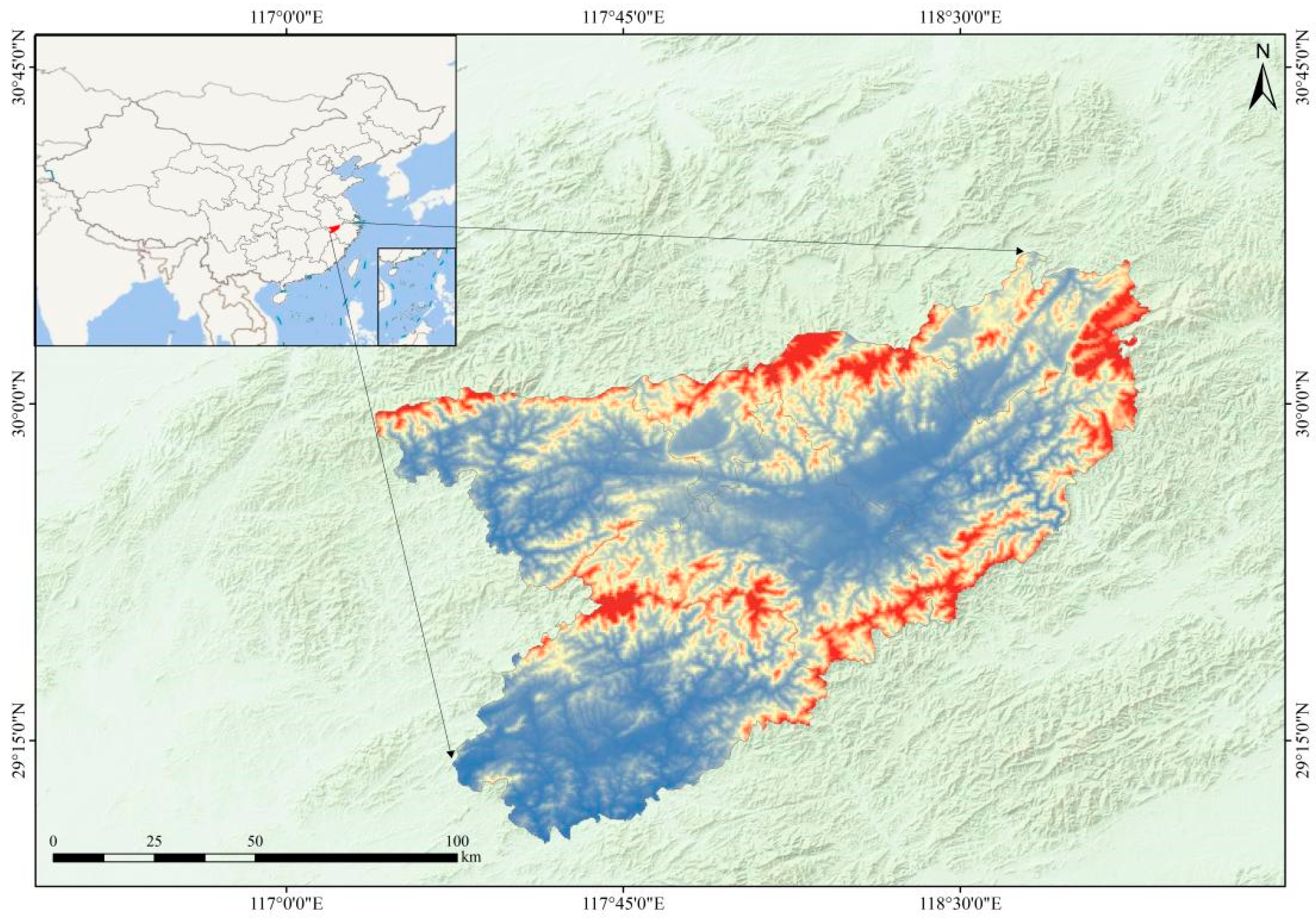
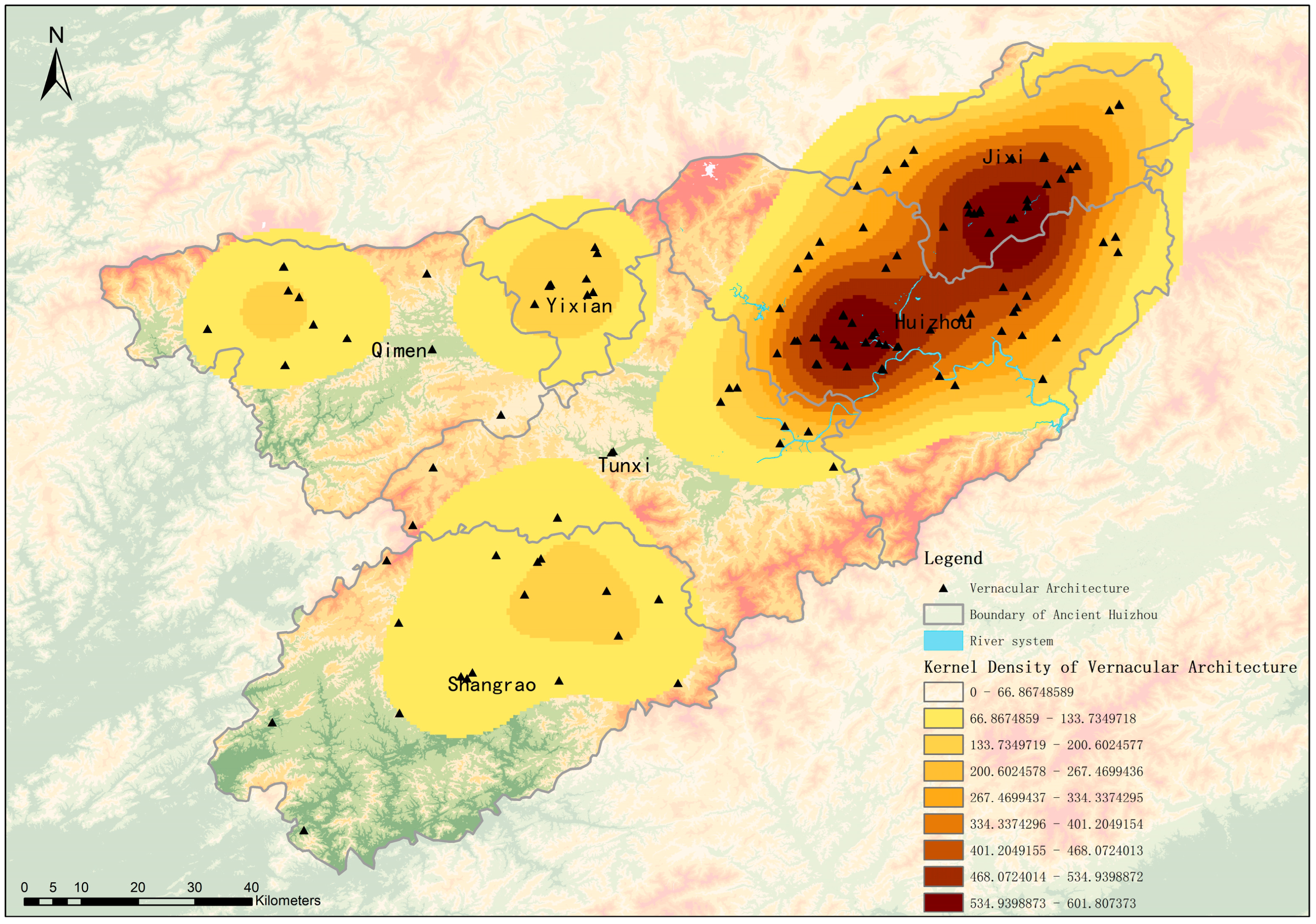
Based on the technical platform of kernel density analysis, this study conducts a spatial analysis of 170 ancestral halls, temples, and other Vernacular Architectures along the roads. The results show that the overall spatial distribution pattern of Vernacular Architectures exhibits a significant characteristic of “multiple cores, multiple zones, and hierarchical diffusion” (see
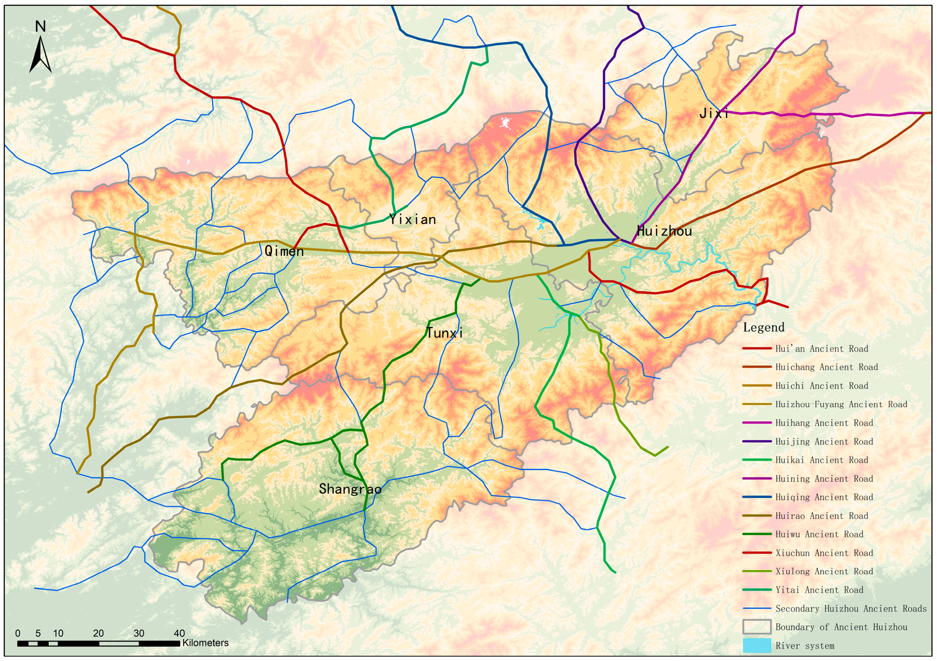
Figure 2). Vernacular Architectures generally take Jixi and Shexian as the core and spread outward hierarchically. The numbers in Wuyuan, Xiuning, Qimen, and Yixian are much lower than those in Jixi and Shexian, but these areas still show an overall pattern of core agglomeration. In terms of the distribution of Huizhou Ancient Roads, most roads start from the prefectural city of Huizhou in Shexian and spread outward (see
Figure 3), with Vernacular Architectures distributed along the routes between origins and destinations. This hierarchical diffusion pattern is consistent with the distribution characteristics of Vernacular Architectures in the Huizhou region, indicating that Huizhou Ancient Roads and Vernacular Architectures share the same core areas and diffusion trends.
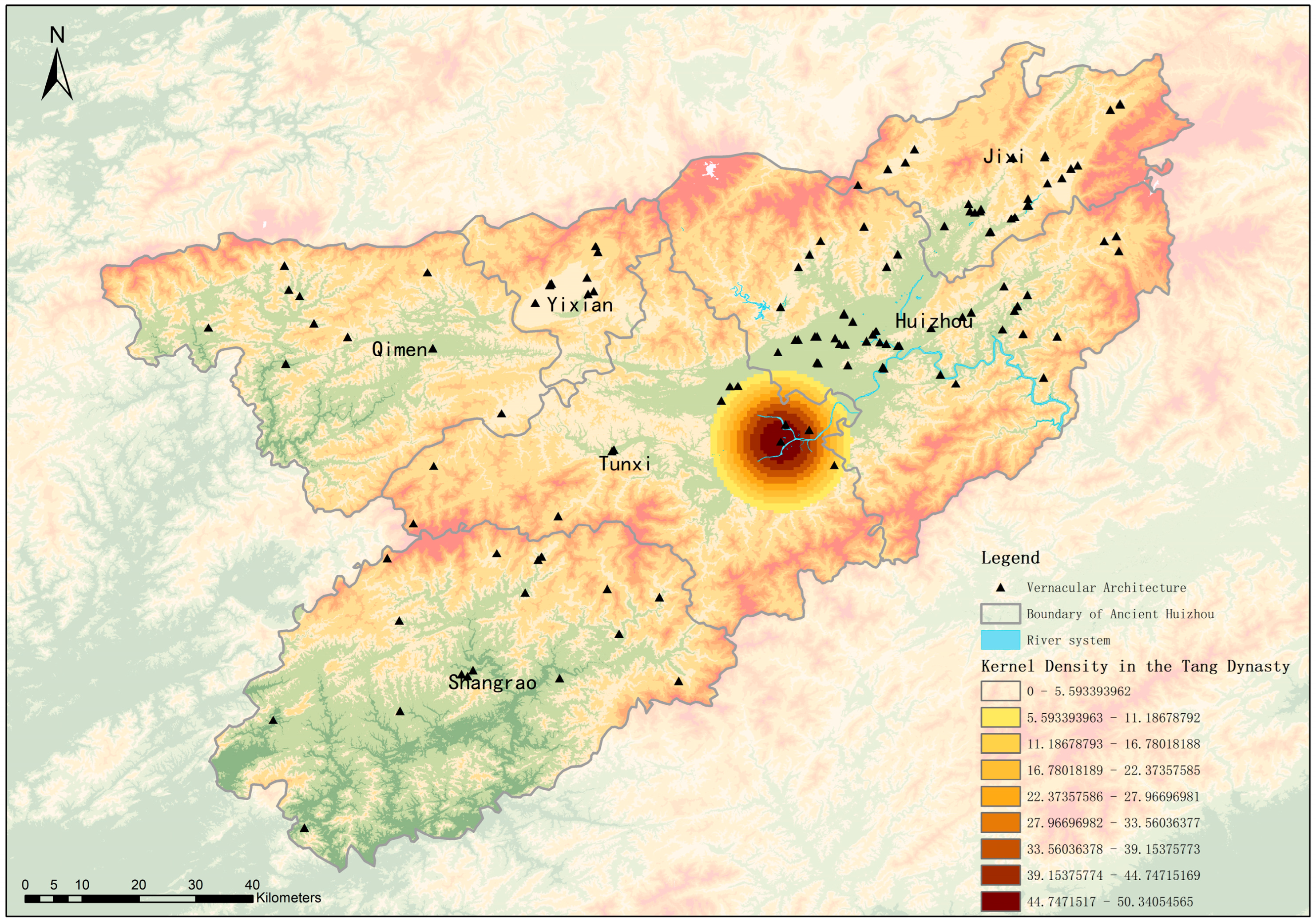
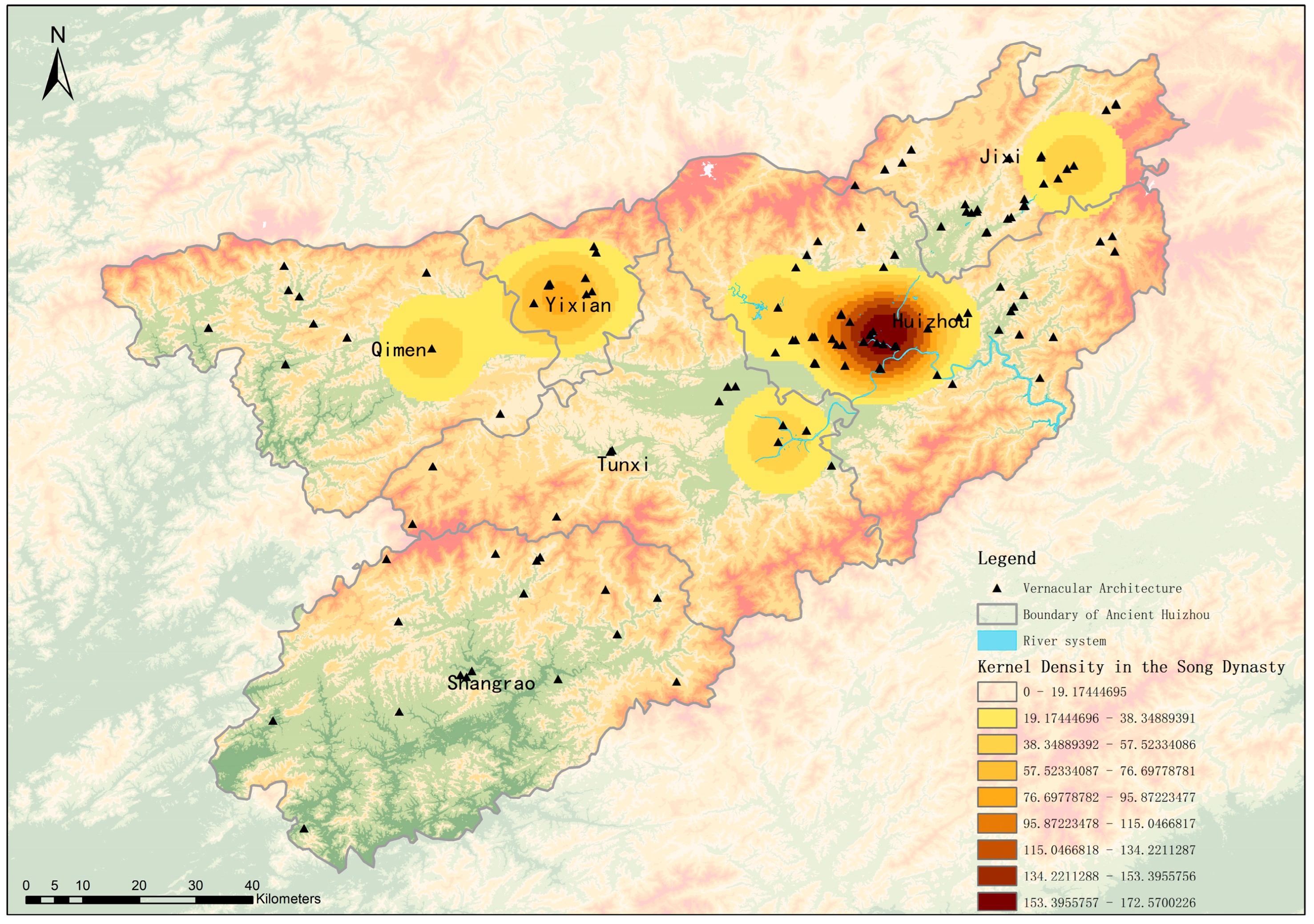
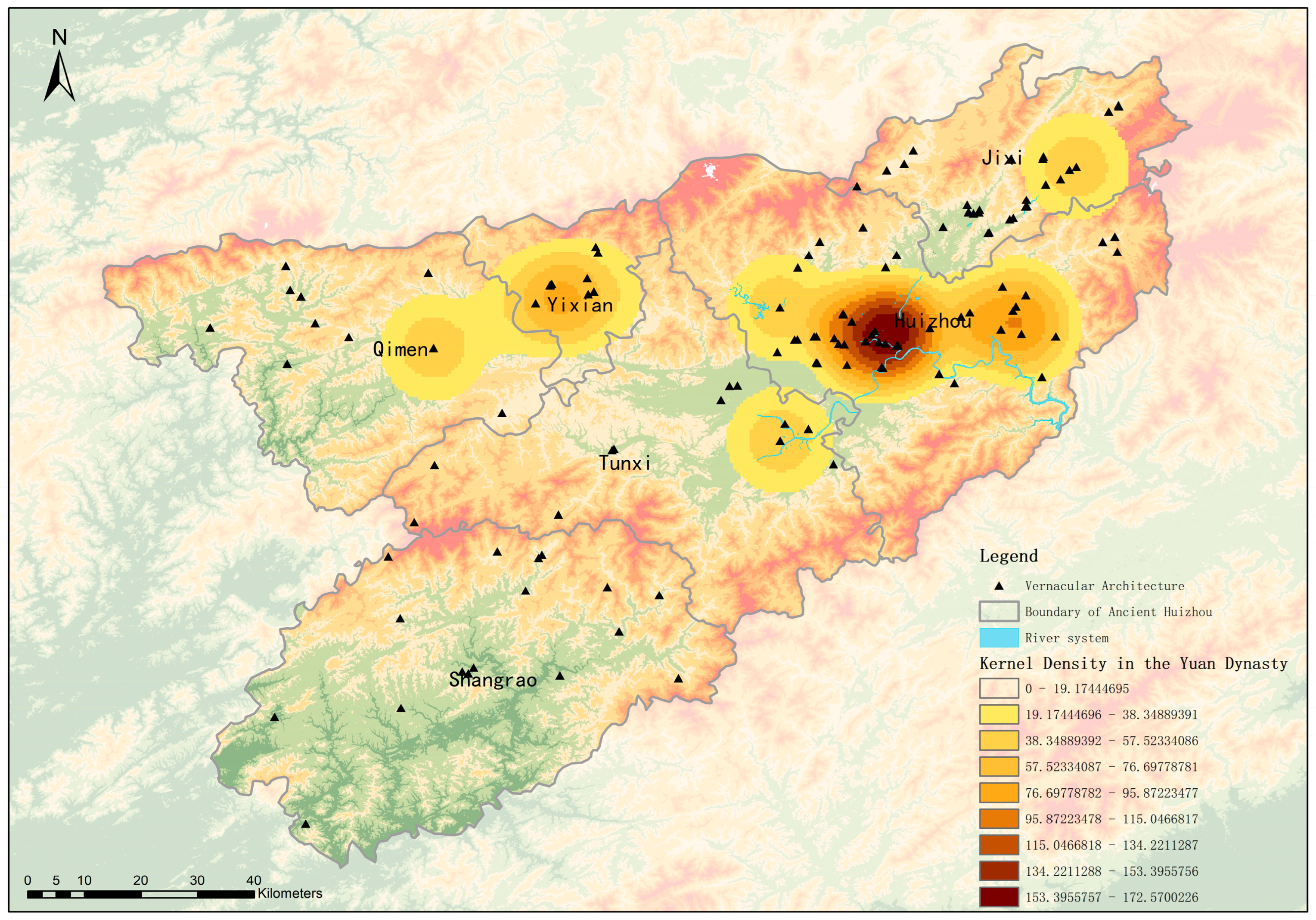
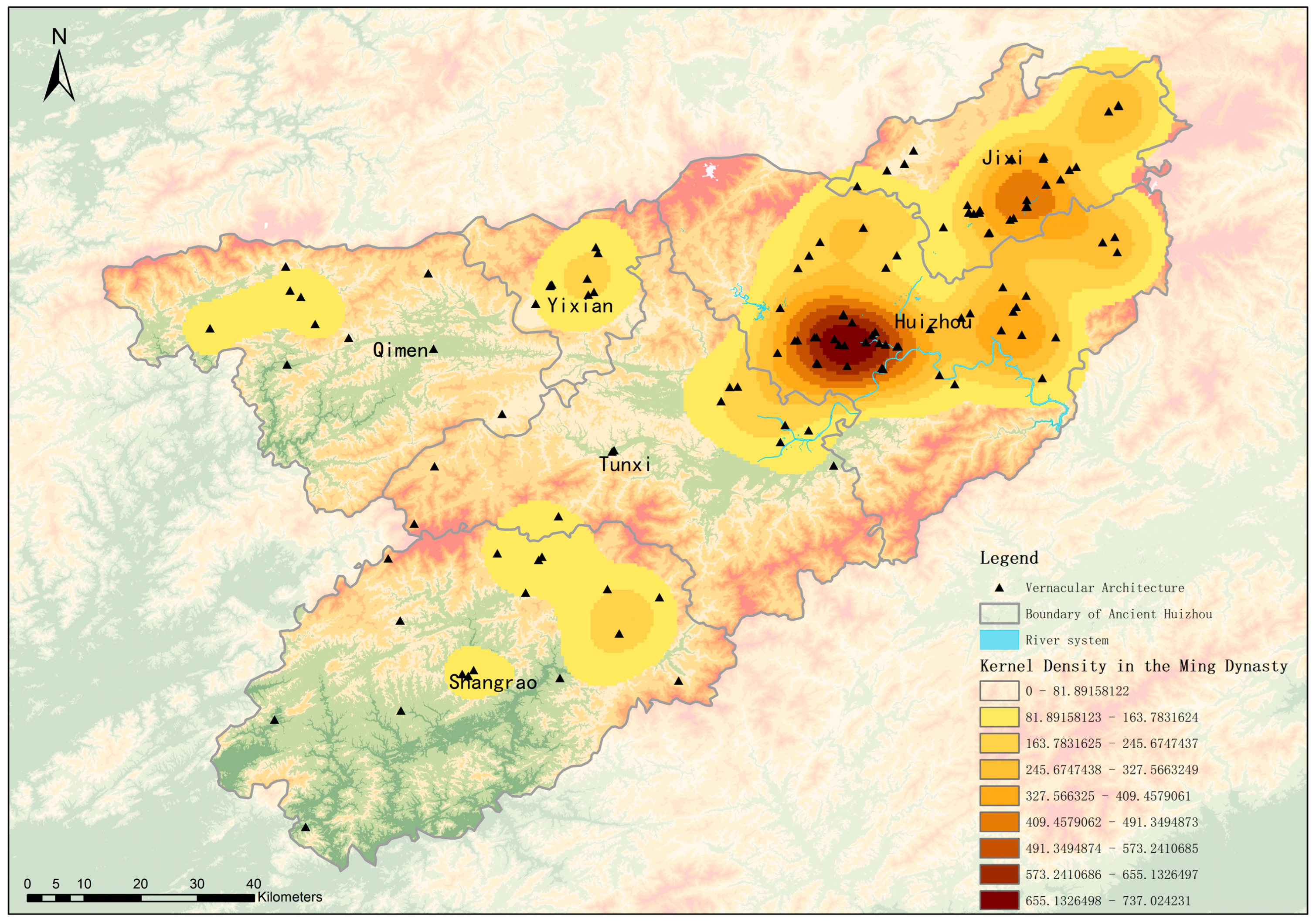
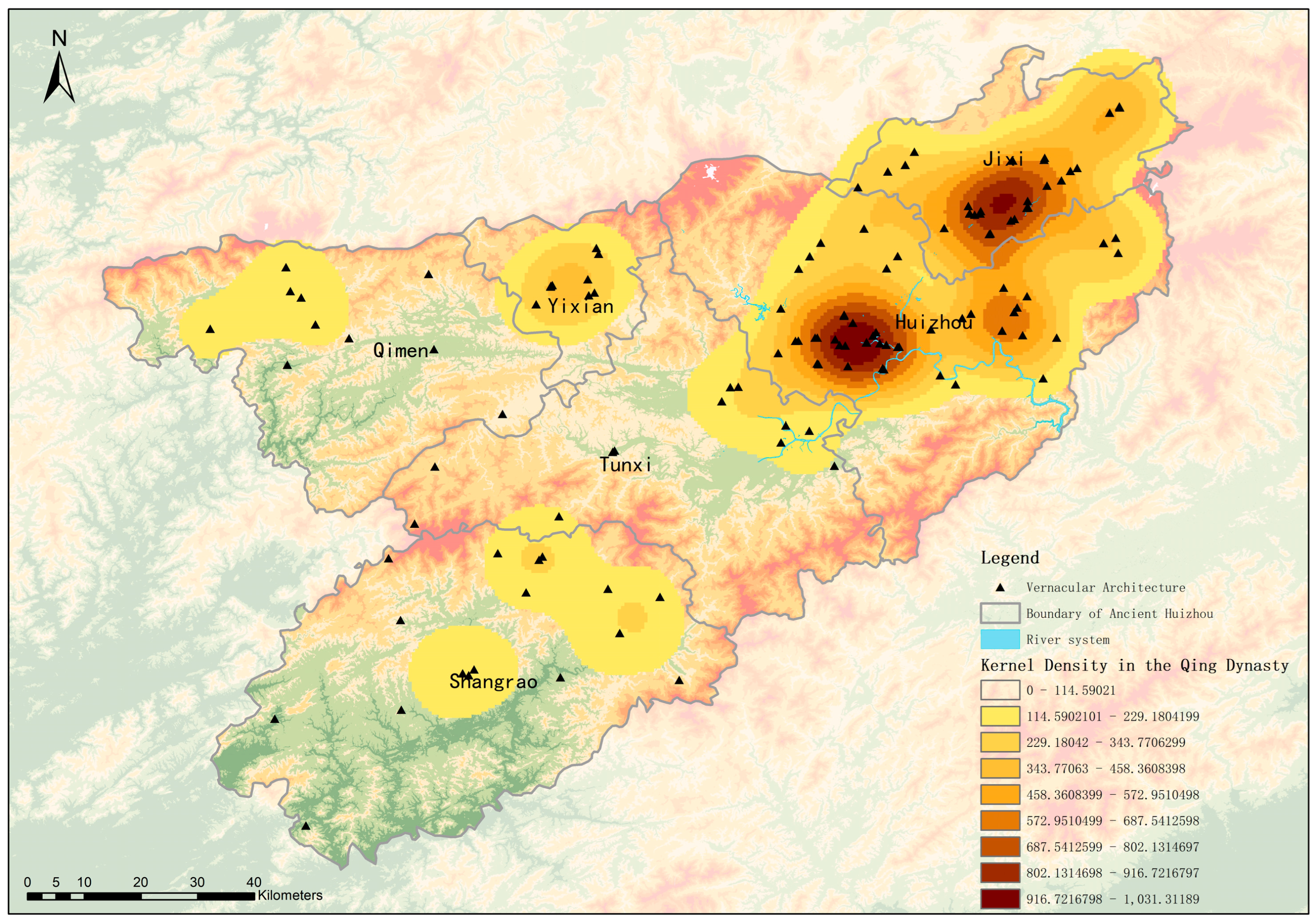
From the perspective of historical spatio-temporal overlay kernel density maps, and taking the dynasty in which Vernacular Architectures were constructed as the classification criterion, the development and evolution of Vernacular Architectures along Huizhou Ancient Roads present an obvious trajectory of spatial migration and diffusion, which is closely intertwined with the historical context and social development of each period. In the Tang Dynasty (see
Figure 4), the core distribution area was located in Tunxi, at the junction of Xiuning County and Shexian County. This core distribution was highly consistent with the early historical background that Wang Hua led local people to construct ancient roads at the end of the Sui Dynasty and laid the initial foundation for regional folk beliefs. In the Song Dynasty (see
Figure 5), after Wang Hua was officially recognized by the court, temples were constructed for him and he was granted the plaque “Zhongxian”, which was later changed to “Zhonglie”, the central area of Vernacular Architectures gradually shifted to Huizhou Prefectural City. The spatial overlap between the administrative center and the belief center effectively promoted the institutionalization and standardization of ritual Architectures and further enhanced their regional influence. In the Yuan Dynasty (see
Figure 6), the kernel density map indicates that Vernacular Architectures began to spread gradually to the surrounding areas of the prefectural city, which was in line with the law of belief communication under the conditions of relatively stable social order and a continuously operating ancient road transportation network. In the Ming Dynasty (see
Figure 7), the density of Vernacular Architectures in Jixi County increased significantly and developed rapidly, which was closely associated with the frequent commercial and trade activities along the ancient roads after the rise of Huizhou merchants and the increasingly prominent role of Jixi as a key transportation hub. In the Qing Dynasty (see
Figure 8), the kernel density distribution showed a pattern of similar density levels between Jixi and Huizhou Prefectural City, and two major core distribution areas were finally formed. This pattern was supported by the sustained economic prosperity of the two regions, which provided sufficient material conditions for the construction and renovation of belief Architectures, and was also closely related to the widespread practice of folk customs such as Wang Gong worship and the deepened influence of regional beliefs. In modern and contemporary times (see
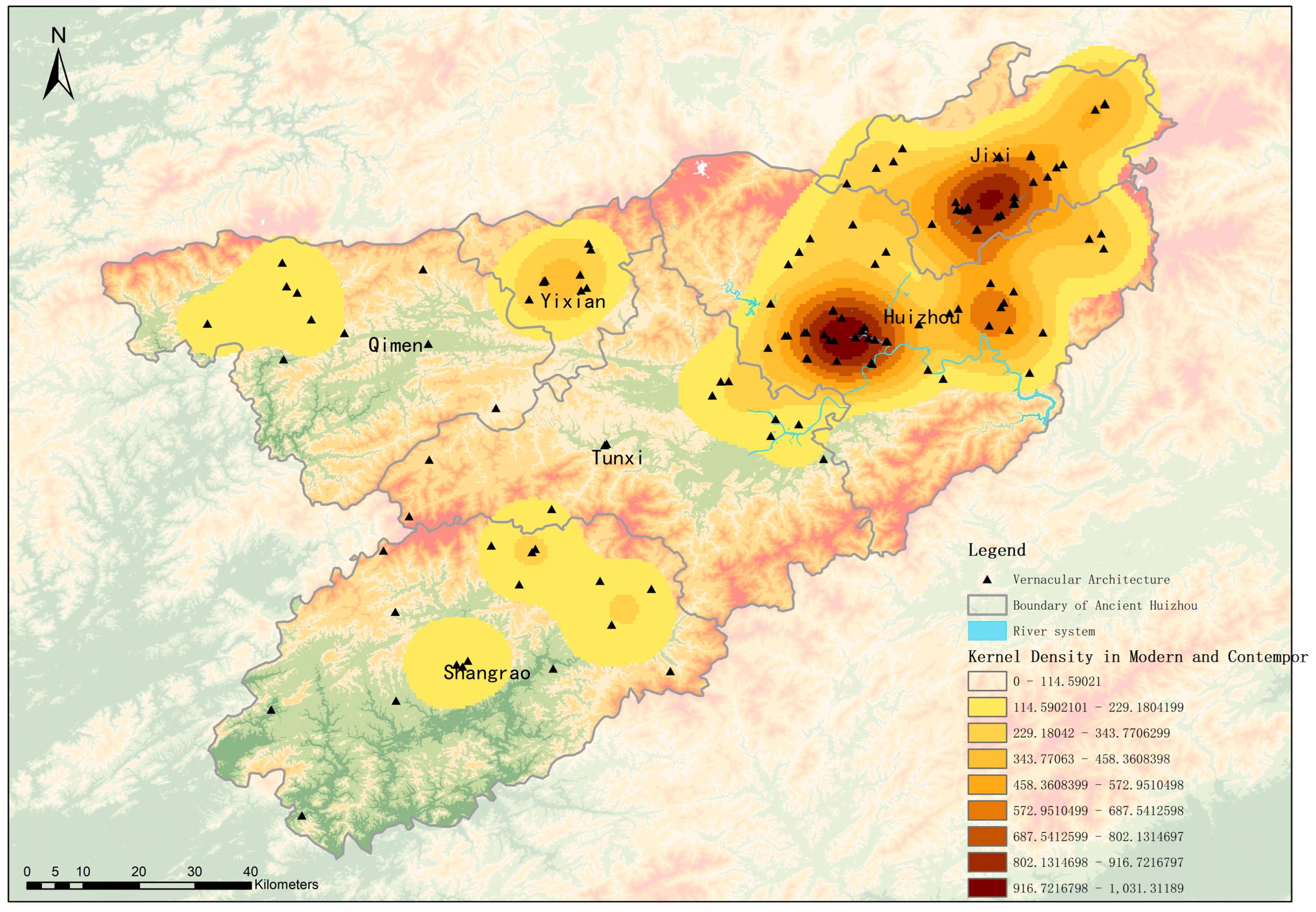
Figure 9), affected by the transformation and innovation of transportation modes, the distribution pattern shown in the kernel density map has tended to be stable with a relatively slow development speed, which is related to the functional transformation of Vernacular Architectures and the insufficient attention paid to their protection and inheritance.
The functional types of Vernacular Architectures along Huizhou Ancient Roads can be classified into five categories: hero worship, deity worship, nature worship, composite worship, and ancestor worship. These five types exhibit a significant characteristic of functional coupling in their spatial patterns.
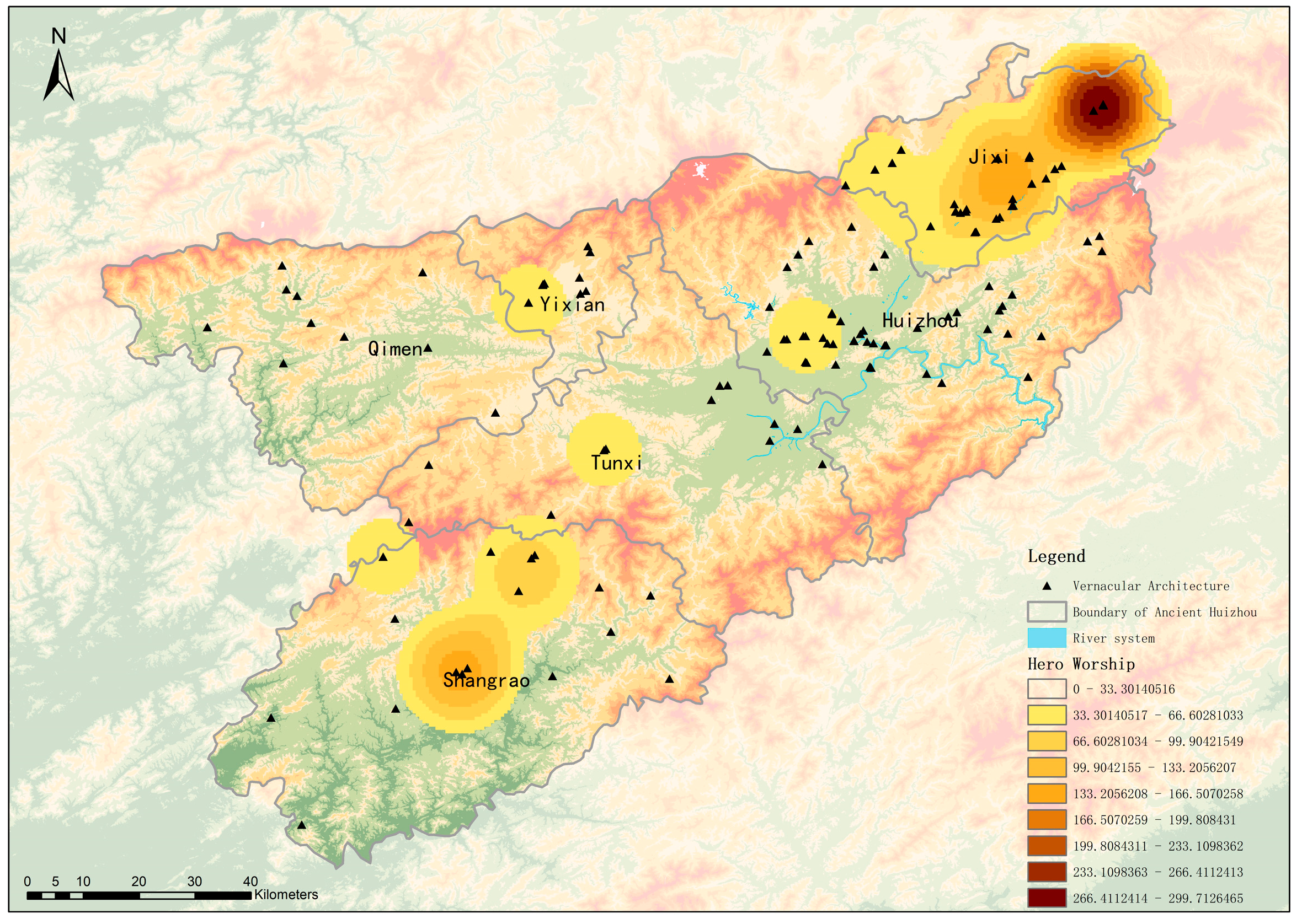
From the analysis of kernel density maps and historical spatio-temporal overlay maps for different belief types, the kernel density results show that the core area of hero worship is located in Jixi County seat (see
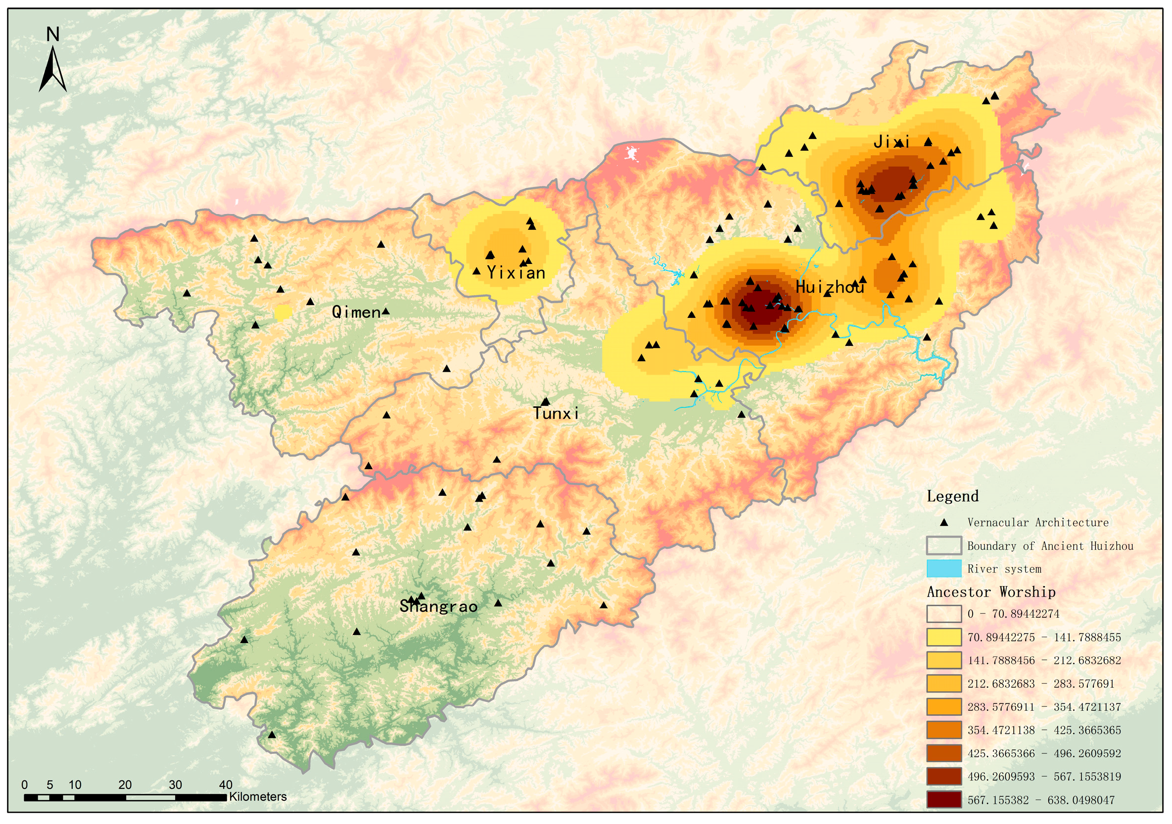
Figure 10). This distribution is closely associated with the historical achievements of Wang Hua in stabilizing and governing the region, where his worship formed a strong cohesive effect. The corresponding ritual shrines and temples developed and expanded along the ancient roads near Jixi, laying the foundation for the symbiotic relationship between belief Architectures and the transportation network. With the stabilization of the social structure and the improvement of the administrative system, the central area of belief Architectures gradually shifted toward the regional political core. Relying on its prominent administrative status, Huizhou Prefectural City became a new high-density agglomeration zone for religious constructions. In terms of kernel density distribution, ancestor worship covers a relatively wide spatial range, yet its core zone remains concentrated near Huizhou Prefectural City (see
Figure 11), which is closely related to the centralized development of Huizhou lineage forces in and around the prefectural city. During this period, hero worship was incorporated into the official ritual system, leading to more standardized construction of temples and shrines, and the types of folk beliefs expanded from a single form to diversified ones. Meanwhile, the core status of Huizhou Prefectural City and Jixi began to take shape.
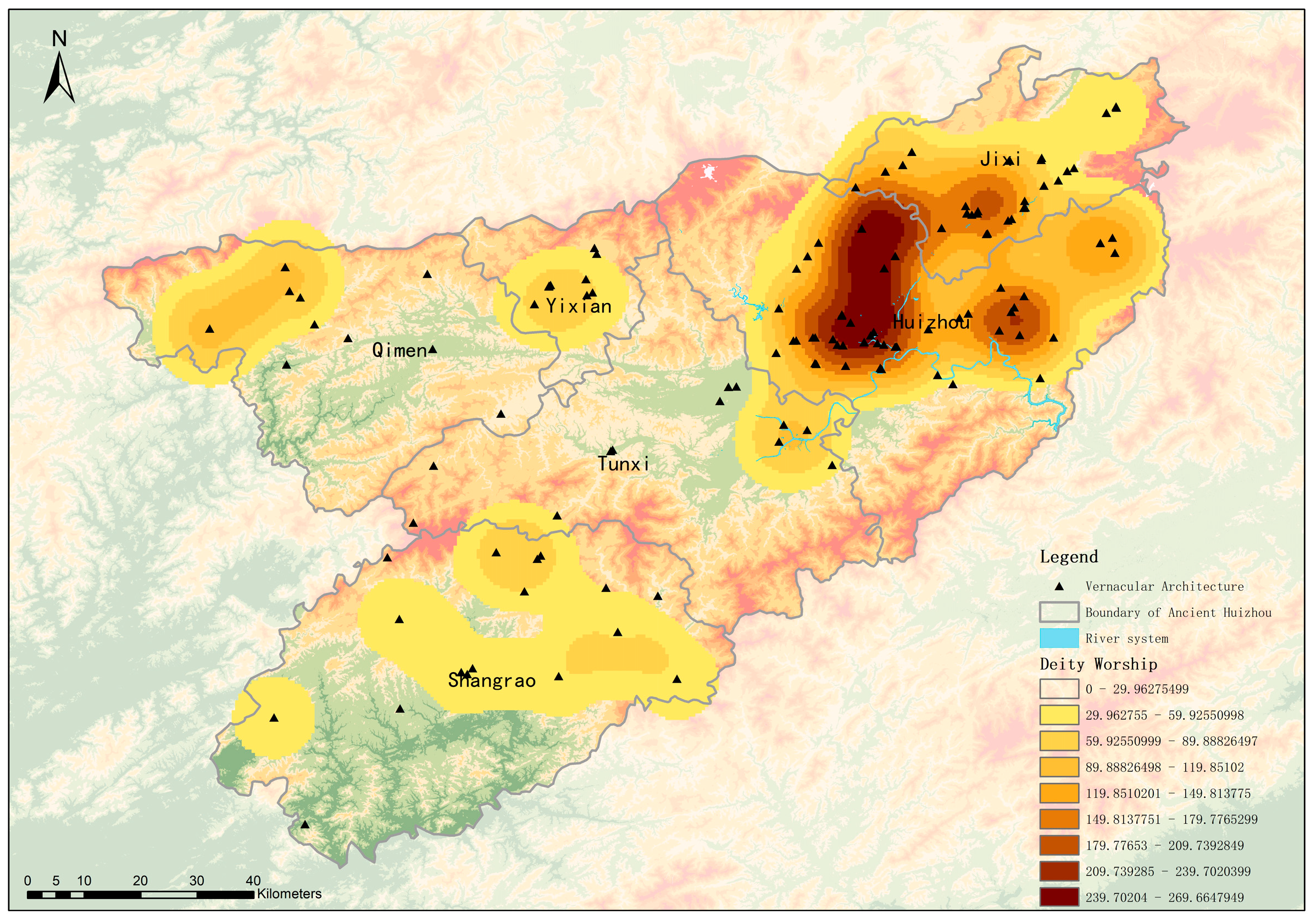
In the stage of prosperous commercial and trade activities, the ancient roads, as critical corridors for material circulation and population mobility, promoted the diffusion and differentiation of belief Architectures. Kernel density maps indicate that the core zone of deity worship is located in Xiuning and Qimen (see
Figure 12). Such beliefs, which closely correspond to the daily needs of local people, are densely distributed around post stations and markets in these two regions. As an emerging transportation hub, Jixi attracted a large floating population due to flourishing commerce, resulting in a further increase in Architectures dedicated to hero worship and ancestor worship, forming a spatial correspondence with Huizhou Prefectural City. Within the overall spatial pattern of “core agglomeration and linear diffusion along roads”, the centrality of Shexian and Jixi became increasingly prominent.
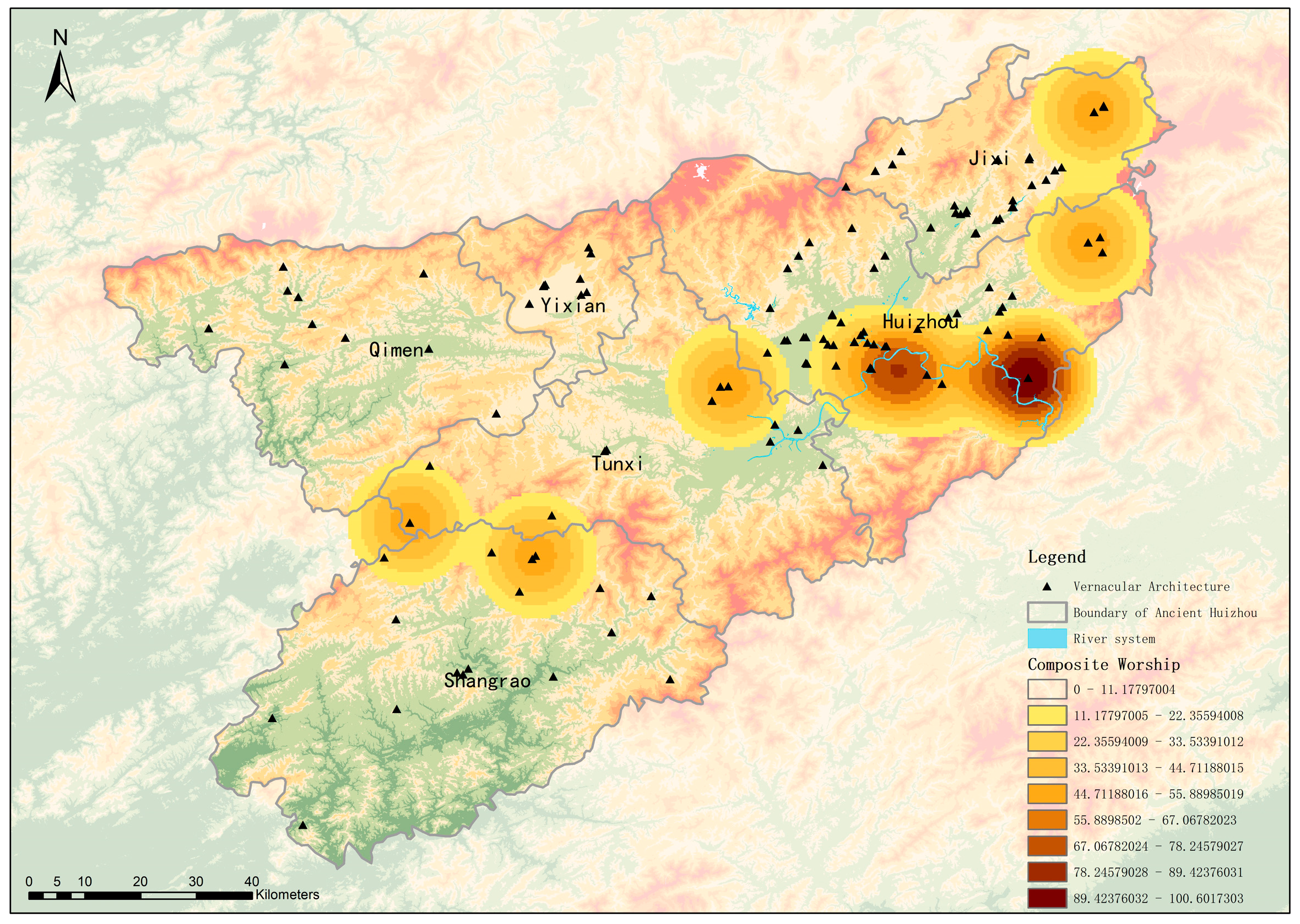
Over time, different types of beliefs gradually integrated and permeated each other, giving rise to Architectures for composite worship. The kernel density core of composite worship is located near Shexian (see
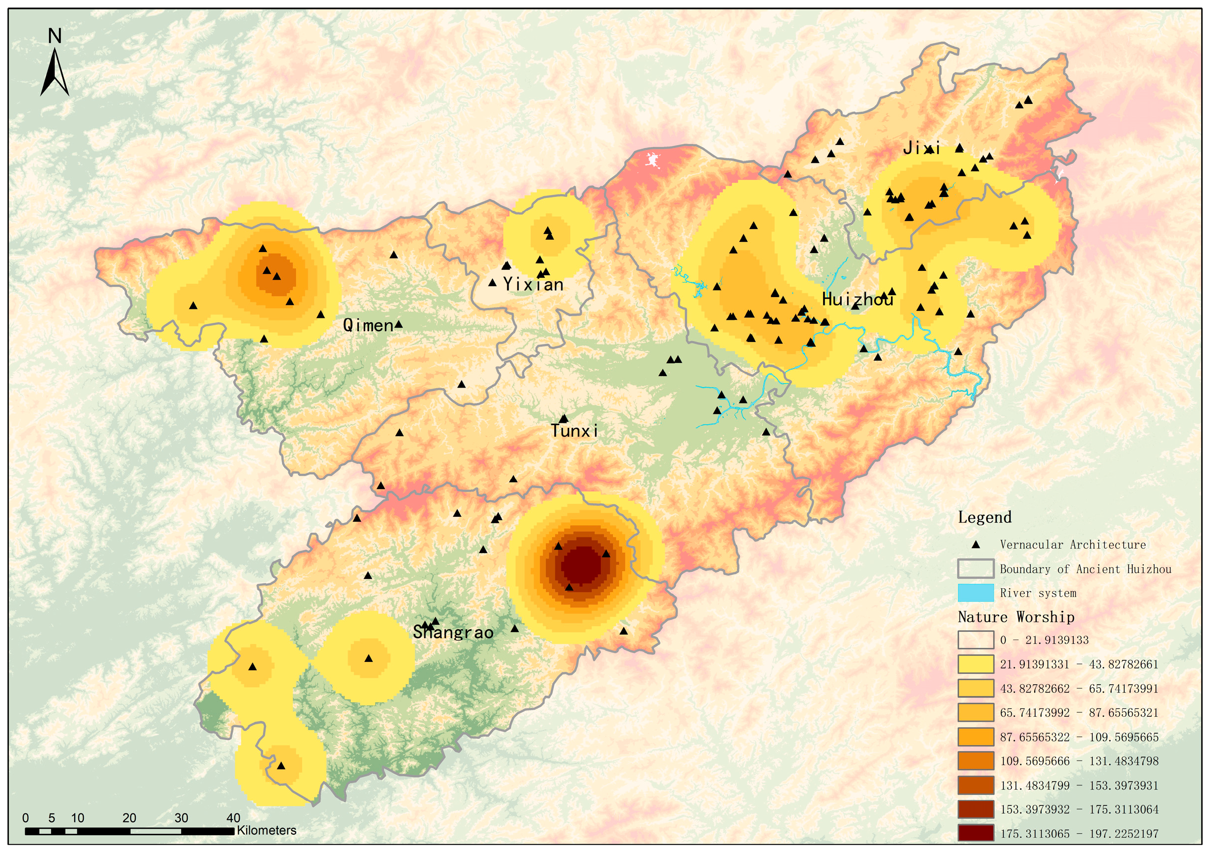
Figure 13), where numerous structures simultaneously carry out the functions of hero sacrifice, ancestral enshrinement, and deity worship, reflecting the strong inclusiveness of Huizhou folk beliefs. By contrast, the core zone of nature worship is situated in Jixi and Huizhou Prefectural City (see
Figure 14), which is closely tied to the mountainous and riverine natural environment of the two areas, forming stable agglomerations at key natural nodes. During this period, supported by the high-density distribution of composite worship, nature worship, and other religious forms, Shexian and Jixi consolidated their positions as core regions where diverse types of folk beliefs intersect and integrate.
Based on the above kernel density analysis, the spatiotemporal relationships between different types of Vernacular Architectures in different dynasties and Huizhou Ancient Roads can be identified. However, kernel density analysis cannot visually illustrate the specific directional trends of their development. In contrast, the GIS-based Standard Deviational Ellipse analysis can effectively reveal the directional trends and degrees of spatial expansion.
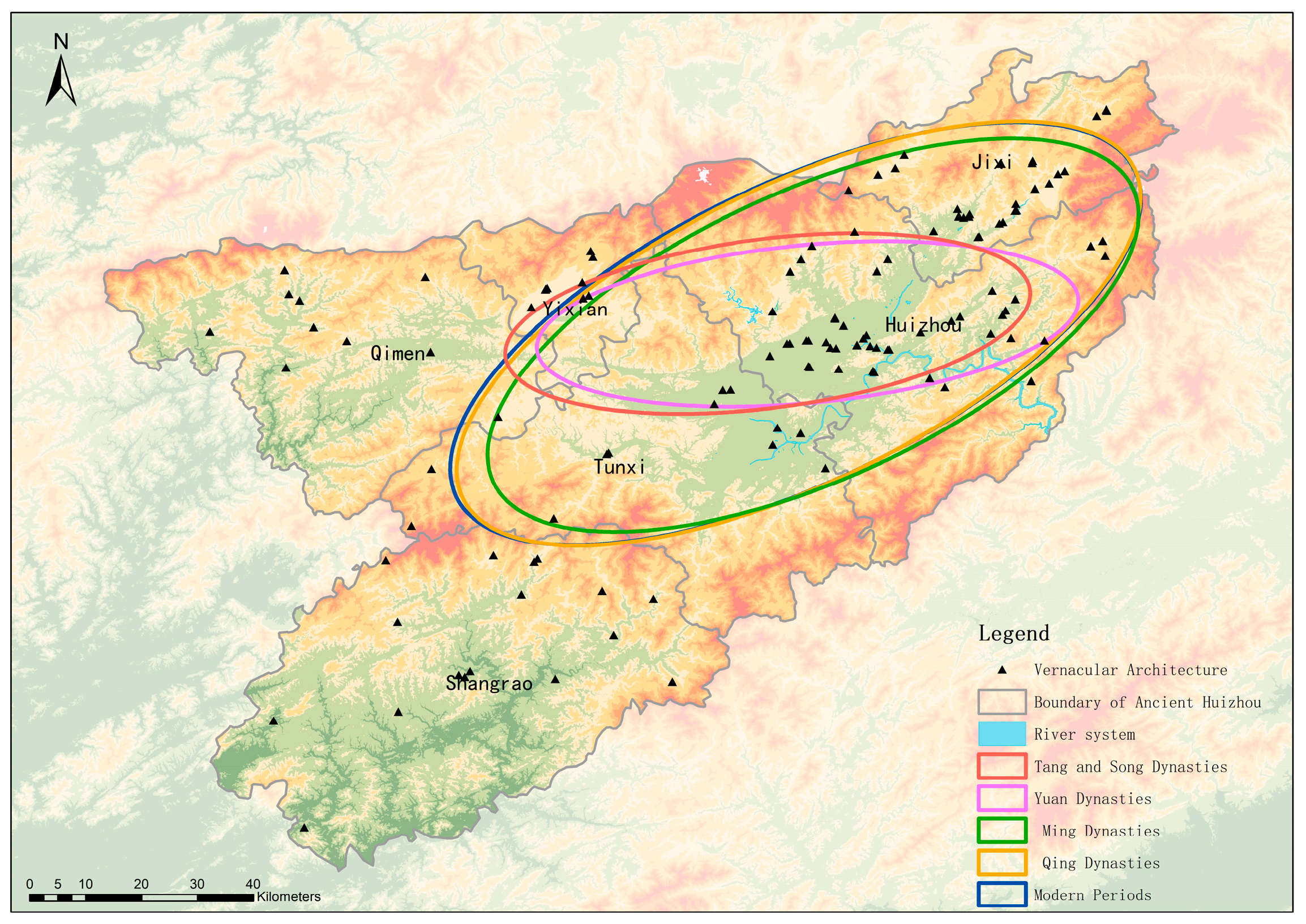
Standard Deviational Ellipse analysis by dynasty (see
Figure 15) shows that the spatial distribution centers and diffusion directions of Vernacular Architectures in different historical periods have been highly consistent with the developmental context of the Huizhou Ancient Road network. In the Tang Dynasty, the center of the ellipse corresponded to the Tunxi area at the junction of Xiuning and Shexian, and the major axis was basically consistent with the direction of the early ancient roads constructed by Wang Hua in the late Sui Dynasty. The ellipse had the smallest area and relatively high flatness, indicating that belief Architectures at this stage were mainly concentrated along the initial ancient roads within a limited spatial range. In the Song Dynasty, the ellipse center shifted toward Huizhou Prefectural City, and the major axis extended along the Huining, Huijing and other ancient roads radiating from the prefectural city, with a slightly larger area than that in the Tang Dynasty, reflecting the preliminary expansion of belief Architectures along the ancient road network around the prefectural city after the establishment of the administrative center. In the Yuan Dynasty, the ellipse area further increased, the major axis fitted the diffusion paths from the prefectural city to surrounding counties via ancient roads, and the flatness decreased, indicating that under social stability, beliefs spread to wider regions along the ancient roads. In the Ming Dynasty, the ellipse center obviously shifted toward Jixi, and the major axis formed a bidirectional extension pattern between Huizhou Prefectural City and Jixi. In the Qing Dynasty, the ellipse reached its maximum area, the major axis stably covered the main trunk routes connecting Huizhou Prefectural City and other regions, and the flatness was the lowest. In modern and contemporary times, the ellipse center showed no obvious migration, but the direction of the major axis tended to be gentle, with an area basically unchanged from that in the Qing Dynasty.
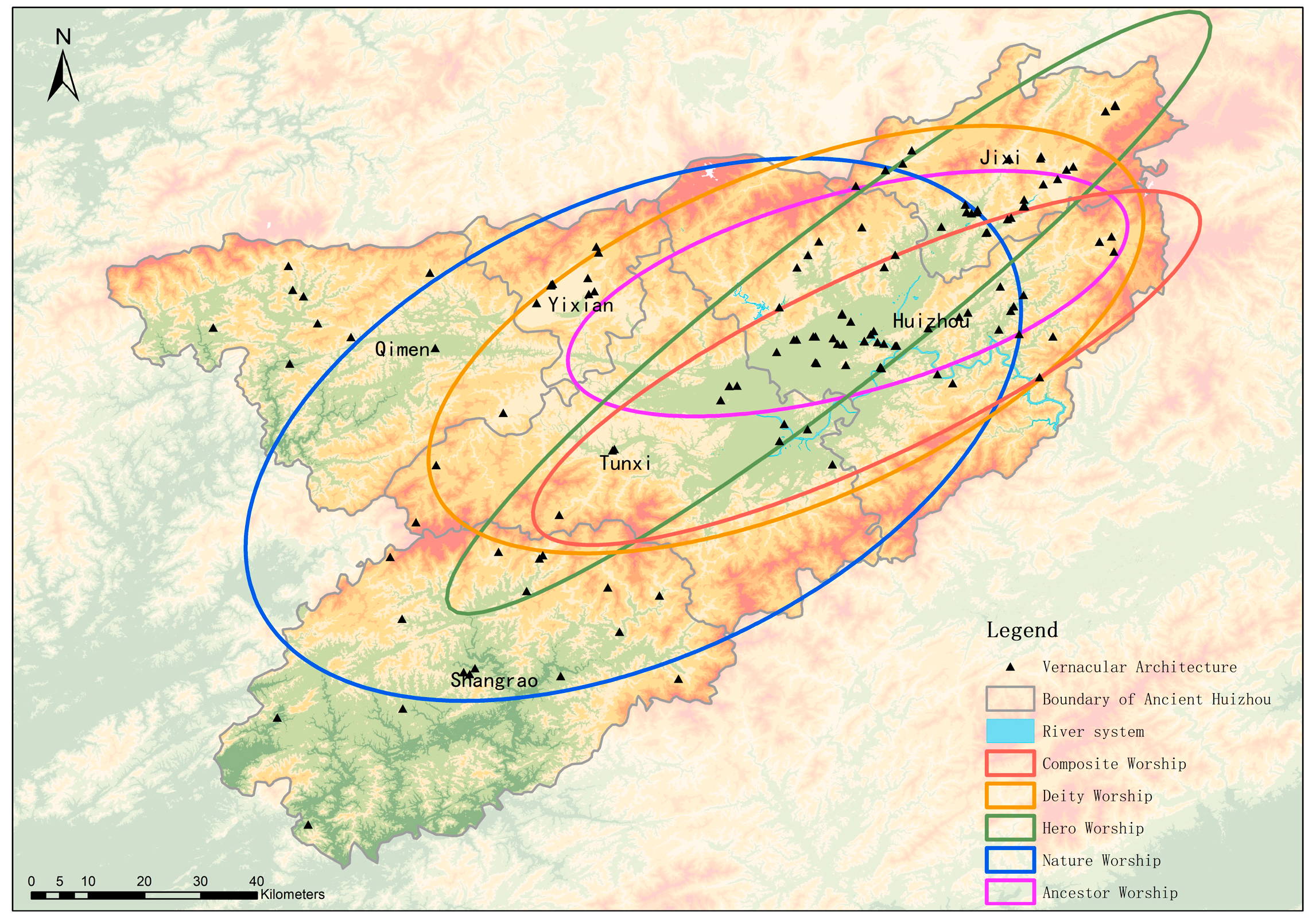
Standard Deviational Ellipse analysis by belief type (see
Figure 16) indicates that the differences in the spatial development directions and ranges of Architectures of different belief types are essentially reflections of the adaptability between their functional demands and the ancient road network. The ellipse center of hero worship Architectures is located in Jixi County seat, with the major axis extending along the busiest commercial and tourist ancient roads such as the Huihang and Huining routes, featuring the highest flatness and a medium area. The ellipse center of ancestor worship Architectures is close to Huizhou Prefectural City, the major axis covers the ancient roads radiating from the prefectural city to surrounding counties, with the largest area, the lowest flatness and the most balanced distribution. The ellipse center of deity worship Architectures is located at the junction of Xiuning and Qimen, the major axis follows the Xiulong, Xiuchun and other ancient roads connecting agricultural areas, with a medium area. The major axis of the ellipse for nature worship buildings links the ancient road sections along mountains and rivers, with a relatively large area and loose boundaries. The ellipse center of composite worship buildings is near Shexian, with the shortest major axis, the smallest area and low flatness.
From the quantitative analysis based on kernel density and Standard Deviational Ellipse, it can be seen that the Huizhou Ancient Road network and Vernacular Architectures present a deeply coupled relationship in terms of spatial core areas and derivative directions. Their correlation is embodied in the dynamic evolution of historical sequences and also reflected in the differentiated distribution patterns of belief functional types, showing a development trend of mutual adaptation throughout different periods.
3.2. Distribution Types of Vernacular Architectures
Using the “Average Nearest Neighbor” analysis tool embedded in the software, this study measured and calculated the observed average nearest neighbor distance () of Vernacular Architectures along Huizhou Ancient Roads, which was determined to be 1.8131496 km. According to the formula mentioned above, the expected average nearest neighbor distance () of Vernacular Architectures along Huizhou Ancient Roads was calculated as 4.58928711 km. Based on these two values, the Nearest Neighbor Index () was derived as 0.395083. A Z-value test was further conducted to verify the reliability of the result, yielding a Z-score of −15.044231 with a 99% confidence level. This statistical result clearly indicates that the overall spatial distribution pattern of Vernacular Architectures along the linear cultural heritage of Huizhou Ancient Roads is of clustered type.
The results of the average nearest neighbor analysis reveal that Huizhou Vernacular Architectures exhibit a significant spatial agglomeration characteristic. This clustered distribution pattern is closely restricted by the traditional custom of Huizhou clan settlements, which is known as “relocating every five generations” (Wushi Er Qian). Such a distribution feature fully reflects the impact of the belief scope of traditional villages on the spatial layout of Vernacular Architectures. Specifically, this agglomeration trend further forms the functional spatial distribution characteristics of constructing temples at strategic passes and gathering ancestral halls in towns and markets. This spatial pattern not only embodies the rational layout of Vernacular Architectures in response to the living and production needs of ancient Huizhou residents but also indicates a deep consistency between the distribution of Vernacular Architectures and the scope of belief activities of ancient Huizhou residents at that time, reflecting the close connection between folk beliefs and daily life as well as social customs in the historical context of Huizhou.
3.3. Spatial Equilibrium of Vernacular Architectures Along Ancient Roads
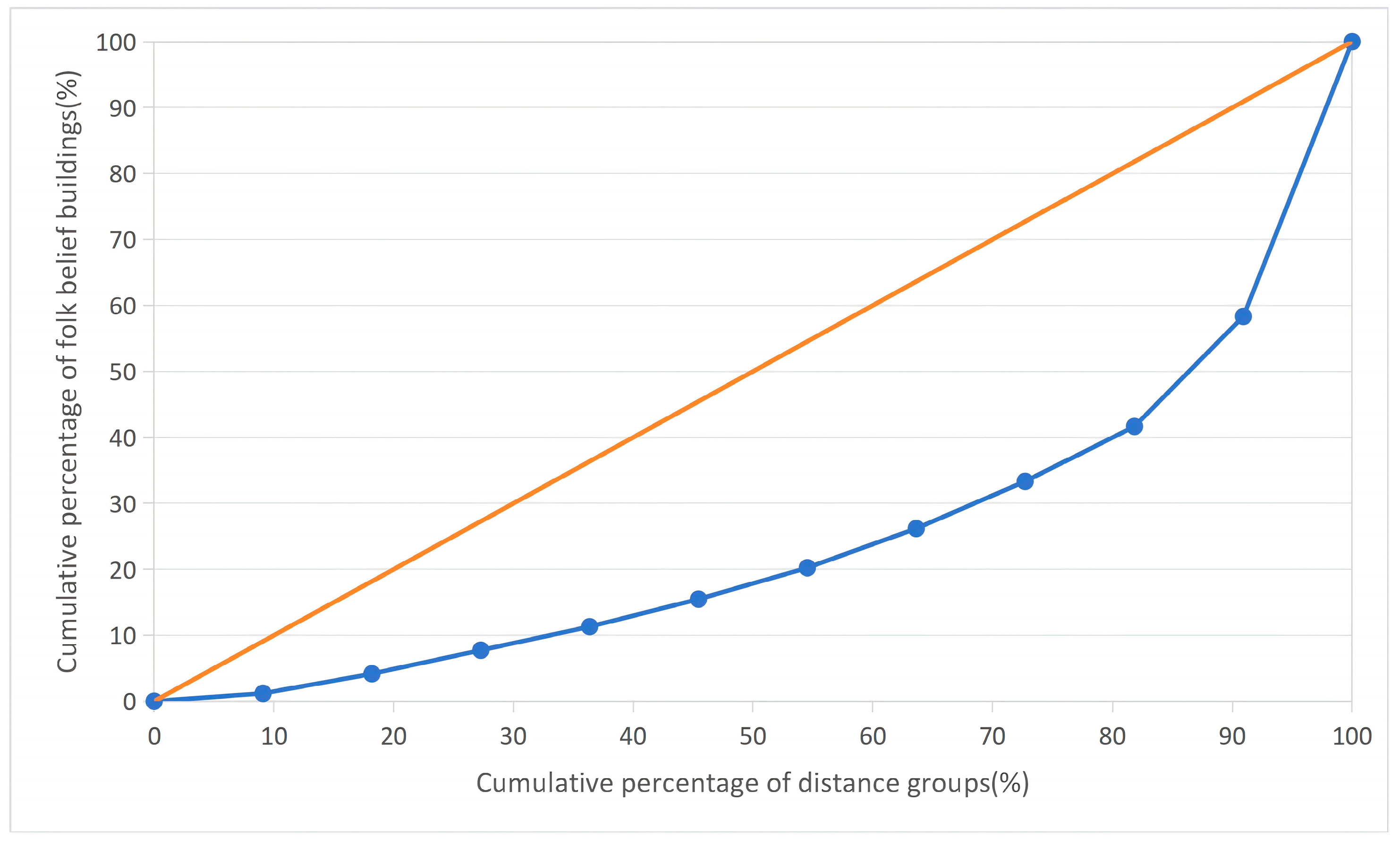
The imbalance index (S) of the distribution of Vernacular Architectures along Huizhou Ancient Roads is no less than 0.347, which indicates that Vernacular Architectures are highly concentrated within the territory of the six counties under one prefecture in ancient Huizhou. As a key indicator reflecting the degree of spatial equilibrium of research objects, the imbalance index S ranges from 0 to 1, and a value of S ≥ 0.347 fully demonstrates that the spatial distribution of Vernacular Architectures along the ancient roads is not evenly scattered but presents a distinct concentrated distribution pattern. This obvious imbalance does not mean an irrational distribution, but rather reflects the unique spatial distribution characteristics of Vernacular Architectures along Huizhou Ancient Roads—such concentration is closely related to the radiation effect of ancient road transportation nodes, the agglomeration of clan settlements, and the spread of folk beliefs, and is also a concrete embodiment of the adaptation between Vernacular activities and the ancient road network. To further visually and intuitively describe the specific distribution status and uneven degree of Vernacular Architectures along Huizhou Ancient Roads, the Lorenz curve is drawn in this study. The Lorenz curve, as a classic tool for analyzing the degree of resource distribution imbalance, can clearly reflect the cumulative distribution relationship between the distance from the ancient roads and the number of Vernacular Architectures, thereby more vividly presenting the spatial distribution characteristics of Vernacular Architectures along the ancient roads.
Through the Lorenz curve diagram (see
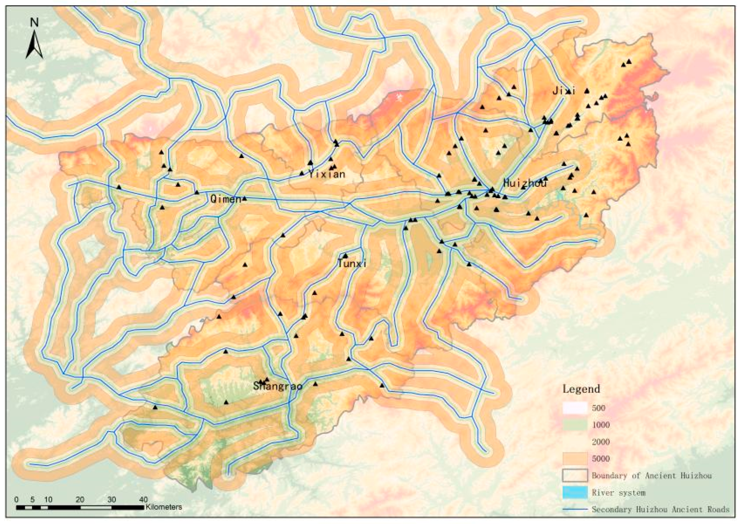
Figure 17) and multi-ring buffer analysis (see
Figure 18), it can be clearly observed that 52.5% of the Vernacular Architectures within the Huizhou Ancient Road area are concentrated in the range of 0–1000 m from the ancient roads, accounting for more than half of the total number. This data fully indicates a high degree of concentration of Vernacular Architectures within this distance range, further verifying the close spatial correlation between Vernacular Architectures and Huizhou Ancient Roads, and reflecting that the distribution of belief Architectures is closely dependent on the ancient road network.
According to the above classification of Vernacular building types, there are obvious differences in the spatial distribution characteristics of different types of belief Architectures in each buffer zone. Specifically, nature worship buildings are most widely distributed in the 1000–2000 m range. Combined with the distribution characteristics of the buffer zones, these areas are mostly traditional agricultural cultivation areas, which is in line with the natural dependence of agricultural production on the natural environment—nature worship, as a belief form closely related to agricultural activities, is widely distributed in agricultural areas, reflecting the deep connection between ancient Huizhou residents’ production methods and folk beliefs. Hero worship buildings take the 0–1000 m range as their main distribution zone, accounting for 25.6% of the total hero worship buildings, and most of them are located in plain areas. This distribution pattern is consistent with the spatial characteristics of population agglomeration and the concentration of belief activities, as plain areas are not only suitable for human settlement and living but also convenient for the organization and development of collective belief activities, which is conducive to the formation of a cohesive effect of hero worship.
Ancestor worship buildings are mainly distributed in the 1000–2000 m range, accounting for 29.8% of the total ancestor worship buildings. Similar to hero worship buildings, they are also mostly concentrated in plain areas, which reflects the deep connection between clan settlement and agricultural environment. In ancient Huizhou, clans often gathered in plain areas with convenient transportation and fertile land for agricultural production, and ancestor worship buildings, as important carriers of clan culture and ancestor worship activities, were naturally distributed in the core areas of clan settlements. Deity worship buildings are most widely distributed in the 0–1000 m range, accounting for 24.7% of the total deity worship buildings. This is because the 0–1000 m range along the ancient roads is the core area of people’s daily life and economic activities, and deity worship, which is closely related to people’s daily life needs such as praying for peace, harvest and prosperity, is more likely to be concentrated in areas with frequent human activities.
Although composite worship buildings are most widely distributed in the 1000–2000 m range, their proportion is only 2.8%, which is the smallest among all types of beliefs. This distribution characteristic reflects that the integration of diverse beliefs in the Huizhou region developed relatively slowly. The slow development of composite worship is closely related to the strong regionality and exclusivity of various beliefs in ancient Huizhou, as well as the relatively stable social structure and cultural traditions at that time, which made it difficult for different types of beliefs to integrate and form new composite belief forms in a short period of time.
Based on the above research results, it can be concluded that most Vernacular buildings are distributed near Huizhou Ancient Roads, which fully indicates that there is a strong correlation between Huizhou Ancient Roads and Vernacular buildings. The influence of Huizhou Ancient Roads on Huizhou Vernacular buildings is reflected in various aspects. The differentiated spatial distribution characteristics of different types of Vernacular Architectures are not only a comprehensive embodiment of Huizhou culture in the distribution of Vernacular Architectures along the ancient roads but also the result of the joint action of the natural environment, production methods and social structure in the long-term process of human–land interaction. Specifically, the ancient road network provides a convenient transportation and communication channel for the spread of folk beliefs and the construction of belief Architectures; the natural environment determines the spatial scope of human activities and further affects the distribution of belief buildings; the production method dominated by agriculture promotes the formation of belief forms closely related to agricultural activities; and the clan-based social structure lays the foundation for the agglomeration distribution of ancestor worship and hero worship buildings. All these factors jointly shape the unique spatial distribution pattern of Vernacular buildings along Huizhou Ancient Roads.
3.4. Influencing Factors
To explore the influencing factors of Huizhou Ancient Roads on the distribution of Vernacular Architectures in the Huizhou region, this study refers to relevant academic achievements and combines the regional characteristics of Huizhou Ancient Roads as a “trinity” of “commercial routes, clans, and nature”. On the basis of the traditional analytical framework, this study incorporates ancient road-related indicators to construct an influencing factor system suitable for Huizhou Vernacular Architectures. This constructed system is not only based on the existing research results in the field of spatial distribution of Vernacular Architectures but also fully considers the unique regional connotation of Huizhou Ancient Roads, ensuring that the selected influencing factors are scientific, targeted, and in line with the actual situation of the study area.
Considering the particularity of human–land interaction along the ancient roads, the dependent variable in this study is selected as the density of Vernacular Architectures, which is defined as the number of Vernacular Architectures within a unit grid. This selection is based on the fact that the density indicator can effectively reflect the spatial agglomeration degree of Vernacular Architectures, and can more intuitively and accurately characterize the spatial distribution pattern of belief Architectures in different regions, laying a solid foundation for the subsequent quantitative analysis of influencing factors.
The independent variables are screened from three dimensions, i.e., natural environment, ancient road transportation, and social culture, with specific indicators shown in
Table 4 (see
Table 4). The selection of these three dimensions fully conforms to the comprehensive influence mechanism of human–land interaction on the distribution of Vernacular Architectures. The natural environment is the basic premise affecting the distribution of human activities and architectural construction, as it determines the suitability of the living and production environment in the study area, and further affects the site selection and distribution of Vernacular Architectures. The ancient road transportation dimension, as the core focus of this study, includes indicators closely related to the functions and characteristics of Huizhou Ancient Roads, which is used to accurately measure the impact of the ancient road network on the spread of folk beliefs and the construction of belief buildings. The social culture dimension mainly reflects the influence of human social activities, such as clan settlement and cultural inheritance, on the distribution of Vernacular Architectures, which is an important embodiment of the integration of Huizhou’s unique regional culture and folk beliefs. Each selected independent variable is closely linked to the distribution of Vernacular Architectures, and together they form a comprehensive and systematic influencing factor system, providing a reliable analytical basis for exploring the driving mechanism of Huizhou Ancient Roads on the spatial distribution of Vernacular Architectures.
3.5. Single Factor Influence
The results of factor detection (see
Table 5) show that, except for factor X3, all other factors have passed the significance test at the 99.99% confidence level, which indicates that these factors have a statistically significant impact on the spatial distribution of Vernacular Architectures along Huizhou Ancient Roads, while the impact of factor X3 is not significant and can be excluded from the key influencing factors in subsequent analysis.
There are significant differences in the explanatory power of the three types of factors (natural environment, ancient road transportation, and social culture) on the distribution of Vernacular Architectures along Huizhou Ancient Roads, and the overall order of explanatory power is ancient road transportation > social culture > natural environment. This ranking fully reflects the core role of ancient road transportation in shaping the spatial distribution pattern of Vernacular Architectures, followed by the influence of social and cultural factors, while the natural environment plays a relatively weak restrictive role.
Among all the independent variables, ancient road density (X6, q = 0.54), freight volume (X7, q = 0.349), and settlement density (X8, q = 0.345) rank the top three in terms of explanatory power (q value). The highest q value of ancient road density (X6) indicates that the density of the ancient road network is the most critical driving factor affecting the distribution of Vernacular Architectures—higher ancient road density means more convenient transportation and communication conditions, which not only promotes the spread of folk beliefs between regions but also provides favorable conditions for the construction and development of belief buildings.
Freight volume (X7) ranks second, reflecting the important impact of commercial and economic activities along the ancient roads on the distribution of Vernacular Architectures. Higher freight volume indicates more frequent commercial exchanges and population mobility along the ancient roads, which not only brings economic prosperity to the surrounding areas but also promotes the exchange and integration of folk beliefs, thus attracting the construction of more Vernacular Architectures.
Settlement density (X8) ranks third, highlighting the key role of population agglomeration in the distribution of Vernacular Architectures. Higher settlement density means more concentrated human activities, and Vernacular Architectures, as important carriers of people’s spiritual and cultural activities, are naturally more likely to be distributed in areas with dense settlements to meet the belief needs of local residents.
Overall, the top three factors fully highlight the core driving role of the commercial road network, population agglomeration, and economic foundation in the spatial distribution of Vernacular Architectures along Huizhou Ancient Roads, which is consistent with the previous research conclusion that there is a strong correlation between Huizhou Ancient Roads and Vernacular Architectures.
Ancient road density and freight volume directly reflect the traffic accessibility and commercial activity along Huizhou Ancient Roads. Their high q values (with ancient road density X6 at q = 0.54 and freight volume X7 at q = 0.349) indicate that Vernacular Architectures exhibit a strong agglomeration characteristic along the node areas of Huizhou Ancient Roads, such as villages and market towns. Specifically, high traffic accessibility brought by dense ancient road networks enables convenient population mobility and cultural exchange, while high commercial activity means frequent economic interactions and population gathering along the roads. These two factors together promote the concentration of Vernacular Architectures in key nodes along the ancient roads, as these nodes not only serve as transportation and commercial hubs but also become important venues for people to carry out belief activities, further verifying the close coupling relationship between the ancient road network and the spatial distribution of belief Architectures.
Settlement density (X8, q = 0.345) reflects the intensity of social activities in the study area, as it directly reflects the degree of population agglomeration and the scale of human activities. Statistical data show that Vernacular Architectures in areas with high settlement density during the Ming and Qing dynasties account for 65% of the total number of belief buildings in this region (calculated based on spatial overlay analysis of 170 vernacular architecture points and Ming-Qing settlement distribution data in ArcGIS 10.8, where high settlement density is defined as areas with population density > 2.04 persons/km2). This data strongly verifies the traditional rule of “where people gather, temples thrive”—in areas with dense settlements, the demand for spiritual and cultural activities is more concentrated, and Vernacular Architectures, as important carriers of these activities, are naturally more likely to be constructed and developed, forming a spatial pattern of mutual adaptation between human settlements and belief buildings.
Intangible cultural heritage (ICH) density is significantly positively correlated with the number of Vernacular Architectures. This correlation is because Vernacular buildings are not only places for religious activities but also important carriers for the inheritance and protection of intangible cultural heritage in Huizhou. Many folk customs, rituals, and traditional arts related to folk beliefs are carried out and inherited in these buildings, and the dense distribution of intangible cultural heritage also promotes the construction and maintenance of belief buildings, forming a positive interaction between cultural inheritance and architectural distribution.
In contrast, factors such as elevation (X1, q = 0.136) and slope (X2, q = 0.125) have relatively weak explanatory power, with q values less than 0.15. This indicates that natural obstacles such as terrain elevation and slope do not directly restrict the generation and development of folk beliefs and related buildings. Instead, they indirectly affect the spatial distribution of belief activities by limiting population accessibility and the construction of settlements. For example, areas with high elevation and steep slopes are not suitable for human habitation and transportation, leading to sparse population and limited belief activities, which in turn results in fewer Vernacular Architectures. However, as long as there are accessible transportation routes (such as ancient roads) and concentrated human settlements in these areas, Vernacular Architectures can still be constructed and developed, further confirming that the ancient road network and social factors play a more dominant role than natural factors in shaping the spatial distribution of Vernacular Architectures.
3.6. Multi-Factor Influence
The development of Vernacular Architectures along Huizhou Ancient Roads is a complex phenomenon resulting from the mutual coupling and joint action of multiple factors. To deeply explore the influence characteristics of the interaction between different factors on the spatial differentiation of local cultural spaces (i.e., the spatial distribution of Vernacular Architectures), factor interaction detection was adopted in this study. This analytical method can effectively identify the interactive relationship between different influencing factors and quantify the combined driving effect of their interaction on the spatial differentiation of Vernacular Architectures, which is crucial for revealing the comprehensive driving mechanism of the development and distribution of Vernacular Architectures.
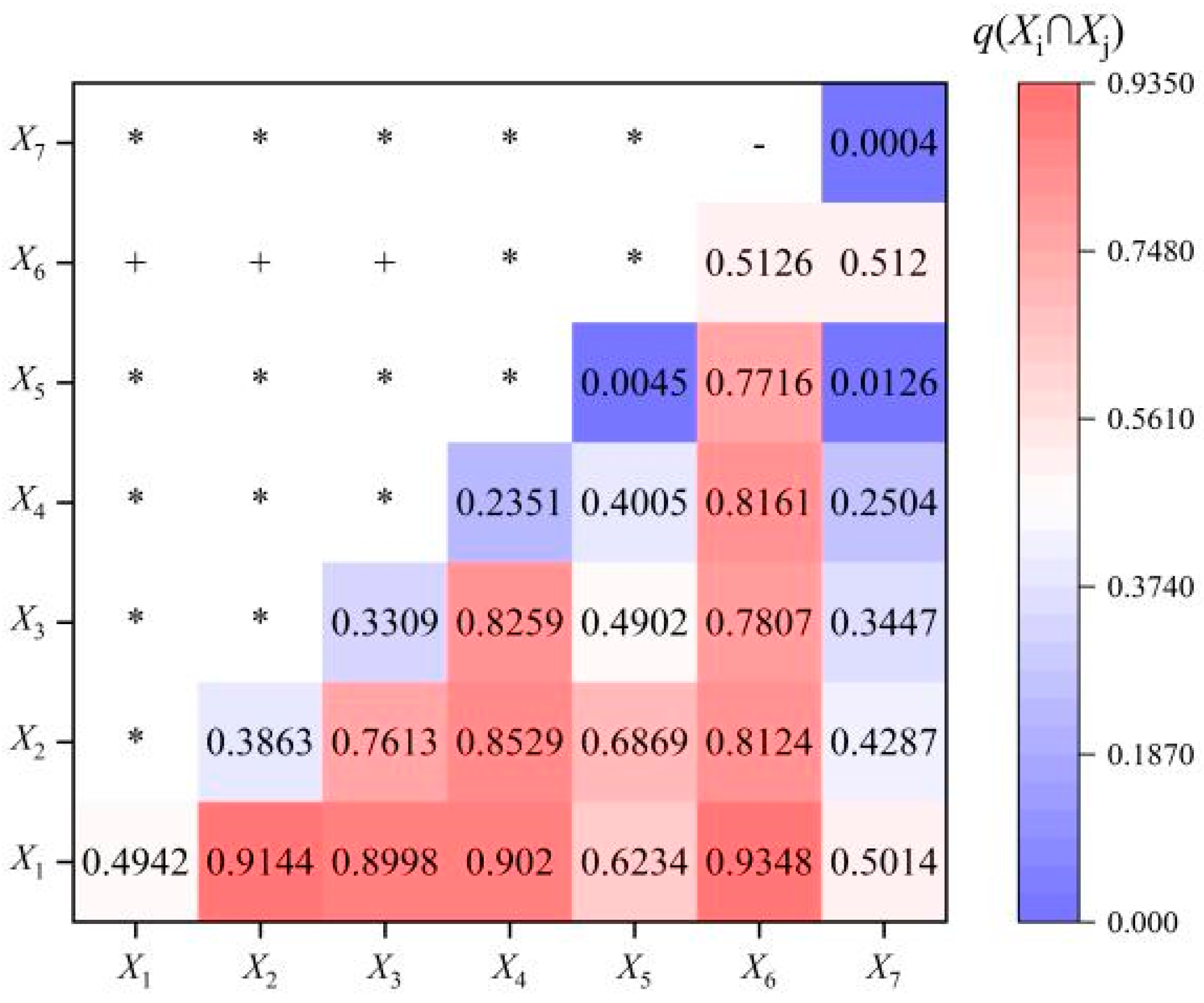
Based on the results of the previous factor detection, 7 reasonable influencing factors that passed the 99.99% confidence level test and had significant explanatory power were selected for factor interaction detection. The results of the factor interaction detection (see
Figure 19) show that the driving force of the two-factor interaction is stronger than that of the single factor acting independently. This indicates that the spatial differentiation of Vernacular Architectures is not affected by a single factor in isolation, but by the combined coupling effect of multiple factors, which further verifies the complexity of the formation mechanism of the spatial distribution pattern of Vernacular Architectures along Huizhou Ancient Roads.
The interaction types between the two factors mainly include two categories: nonlinear enhancement and two-factor enhancement. Nonlinear enhancement means that the combined driving effect of the two factors is significantly greater than the sum of their individual effects, showing a synergistic amplification effect; two-factor enhancement means that the combined driving effect of the two factors is greater than the effect of each factor acting alone, but the amplification effect is relatively moderate. Both interaction types fully reflect the positive synergy between different factors, which jointly promote the formation and evolution of the spatial distribution pattern of Vernacular Architectures.
In terms of the optimal interaction factors, the interaction between transportation factors and social factors is the strongest (
Supplementary Table S2). In particular, the three factors—road density (X6), building distance (X7), and settlement density (X5)—have significantly higher interaction intensity with other factors than the interaction between other factors. This result further indicates that the level of economic, transportation, and social development is the decisive indicator for the development and distribution of Vernacular Architectures. Specifically, road density and building distance, as core indicators of transportation and economic activities, directly determine the accessibility of the region and the frequency of population and cultural exchanges; settlement density, as a key indicator of social activities, reflects the concentration of human activities and the demand for belief activities. The strong interaction between these three factors and other factors fully demonstrates that the development of Vernacular Architectures is closely linked to the level of regional economic prosperity, transportation convenience, and social activity intensity.
In contrast, the interaction effect of natural factors is significantly weaker than that of economic and social factors. Among natural factors, only the interaction between elevation (X1) and slope (X2) is slightly stronger, while the interaction between other natural factors and other types of factors is relatively weak. This is consistent with the previous conclusion that natural factors have weak explanatory power for the spatial distribution of Vernacular Architectures. In the long-term process of human–land interaction, physical geography (such as elevation and slope) has indeed restricted the intensity of human activities to a certain extent—areas with harsh natural conditions are not suitable for human settlement and large-scale economic activities, which indirectly affects the construction and development of Vernacular Architectures. Therefore, natural factors are still an indispensable part of the comprehensive driving mechanism and cannot be ignored.
However, in the process of adapting to the natural environment, ancient Huizhou residents have gradually evolved unique Huizhou cultural characteristics that are compatible with the local unique natural environment, such as horse-head walls. These cultural characteristics not only reflect the wisdom of ancient Huizhou residents in adapting to nature but also integrate into the construction of Vernacular Architectures, making the spatial distribution of belief Architectures not only restricted by natural factors but also showing a strong adaptability to the natural environment. This further reflects the mutual adaptation and coordinated development between human activities, folk beliefs, and the natural environment in the historical evolution of Huizhou.
4. Conclusions and Recommendations
4.1. Conclusions
Vernacular architectures in Huizhou demonstrate a distinct spatial pattern of agglomeration along roads, core diffusion, and cross-regional differentiation. Their distribution centers overlap closely with hubs of the ancient road network, and their historical evolution is fully consistent with the expansion of the road system. Buildings associated with different rural cultural categories correspond precisely to ancient roads of varied functions, forming a stable road–building–people functional symbiosis. The results confirm a deep coupling between the two systems in spatial form, temporal evolution, and functional structure.
Huizhou vernacular architectures exhibit a prominent spatially agglomerated distribution and rely heavily on zones adjacent to ancient roads, showing strong path dependence and spatial directivity. Analysis of influencing factors reveals that ancient road conditions and social agglomeration serve as the core driving forces shaping the spatial layout of vernacular architectures, while natural environments exert only indirect constraints. These findings verify that Huizhou ancient roads represent the key structural force underlying the distribution of vernacular architectures.
From the perspective of cultural sustainability, Huizhou ancient roads and vernacular architectures form an organic system featuring symbiosis between linear heritage and point nodes, which necessitates holistic conservation. This study establishes a four-tiered correlational framework encompassing spatial, mechanism, value, and sustainability dimensions. It further proposes a coordinated strategy centered on corridor connection, node restoration, function activation, and community participation, providing a systematic approach for the scientific protection, living inheritance, and adaptive reuse of Huizhou cultural route heritage.
4.2. Recommendations
Taking Huizhou ancient roads as the main context and vernacular architectures as important nodes, an overall protection pattern of “linear corridors + key nodes” should be established to realize the coordinated protection of linear cultural heritage and point-shaped architectural heritage. By strengthening spatial connection and overall planning, the regional cultural landscape can be maintained complete and authentic, and the continuous inheritance of Huizhou cultural genes can be promoted under the goal of cultural sustainability.
Priority should be given to the restoration and reinforcement of vernacular architectures with high historical value, prominent cultural characteristics and fragile preservation status along ancient roads. Scientific and minimal-intervention conservation technologies should be adopted to retain traditional textures, structural characteristics and cultural connotations, so as to effectively curb the decline and disappearance of characteristic vernacular buildings and consolidate the material foundation for cultural sustainability.
On the premise of protecting the authenticity and integrity of heritage, diversified activation paths should be explored, such as integrating vernacular architectures into rural tourism, cultural research, traditional exhibition, community public services and other scenarios. By endowing traditional buildings with new modern functions, the transformation from static preservation to dynamic inheritance can be realized, and the vitality of Huizhou vernacular culture can be enhanced in the sustainable development.
Local residents, clan organizations and social forces should be widely mobilized to participate in the protection, management and utilization of heritage. The awareness of cultural identity and heritage protection should be improved, and a multi-stakeholder collaborative governance model should be constructed to ensure long-term, standardized and sustainable operation of heritage protection, so as to provide stable institutional guarantee for the sustainable inheritance of Huizhou regional culture.