Article

Karst Geodiversity and Aquatic Habitat Diversity Supporting Endemic Species in Maybrat, Papua Indonesia: Urgency and Policy Implications for Conservation


by
Afia Eksemina Phascalina Tahoba
1,
Hadi Susilo Arifin
2,*,
Rina Mardiana
3 and
Sri Mulatsih
4
1
Study Program of Natural Resource and Environmental Management, Graduate School, IPB University, Bogor 16680, Indonesia
2
Department of Landscape Architecture, Faculty of Agriculture, IPB University, Bogor 16680, Indonesia
3
Human Ecology Faculty, IPB University, Bogor 16680, Indonesia
4
Department of Economics, Faculty of Economics and Management, IPB University, Bogor 16680, Indonesia
*
Author to whom correspondence should be addressed.
Sustainability 2026, 18(7), 3287; https://doi.org/10.3390/su18073287
Submission received: 9 February 2026 / Revised: 11 March 2026 / Accepted: 19 March 2026 / Published: 27 March 2026

Abstract

Karst ecosystems play an important hydrological role in regulating regional water availability and supporting biodiversity, yet they face increasing threats from deforestation, land-use conversion, and limited scientific data to inform sustainable conservation efforts. This study aims to assess karst geodiversity, aquatic habitat diversity, and freshwater endemism in the Maybrat Karst, and to explain the linkages among these three aspects as a scientific basis for regional karst conservation. The research employed geospatial analysis and descriptive ecological analysis. Data were collected through satellite image interpretation, participatory mapping, field observations, and a comprehensive literature review. Results show that the Maybrat Karst has very high geodiversity, with ±2322.91 km2 (41.49%) of the region classified as karst. All seven karst elements were identified, including 40–56 hills/km2, 110 water-filled dolines, 334 springs, 178 subterranean rivers, 90 caves, and three major karst lakes. Aquatic habitat diversity is likewise very high, comprising seven habitat types across the full 100–500 m elevational range, accompanied by 17 Cherax morphotypes, indicating strong environmental differentiation. The literature review identified 18 endemic freshwater species, consisting of five Cherax species, ten rainbowfish species of the genus Melanotaenia, and three additional taxa: Pseudomugil reticulatus, Glossogobius hoesei, and Zenarchopterus ornithocephala. These findings confirm that high karst geodiversity and habitat heterogeneity make the Maybrat Karst a key aquatic endemism center, highlighting the urgent national and global imperative for comprehensive karst protection to safeguard long-term biodiversity and ecosystem sustainability.

1. Introduction

Karst landscapes are widely recognized as among the most distinctive yet environmentally fragile geomorphological systems on Earth. These landscapes evolve through long-term dissolution processes affecting carbonate and evaporite rocks, producing characteristic landforms such as dolines, sinkholes, caves, poljes, conical hills, and complex subterranean drainage networks [1,2]. Beyond their geomorphological uniqueness, karst terrains play a fundamental role in global hydrological systems because they function as natural water reservoirs and groundwater recharge zones that sustain freshwater supply for large human populations [3,4]. Karst aquifers are estimated to provide drinking water to more than one billion people worldwide and therefore constitute an essential component of global water security [3]. In addition to their hydrological significance, karst ecosystems are increasingly recognized as biodiversity hotspots characterized by high ecological specialization and exceptional levels of endemism, particularly within subterranean and groundwater-dependent habitats [5,6]. Despite this ecological importance, karst landscapes remain underrepresented within global conservation frameworks. A considerable proportion of karst regions still lie outside formal protected areas, leaving them highly vulnerable to anthropogenic disturbances such as mining, quarrying, infrastructure development, and land-use change [7,8].
Indonesia contains one of the largest expanses of tropical karst landscapes in the world, extending across the archipelago from Sumatra and Java to Sulawesi and Papua. These karst systems collectively cover more than fifteen million hectares and represent a critical component of the country’s geological and hydrological heritage [9]. Indonesian karst terrains support a wide range of ecosystem services, including groundwater storage, habitat provision for specialized fauna, and long-term carbon sequestration within carbonate systems [2,10]. At the same time, these landscapes are extremely sensitive to disturbance because their porous geological structure makes them particularly susceptible to hydrological disruption and surface degradation. Limestone extraction for cement production, deforestation, and unregulated tourism development have become major threats to many karst regions across the country. Although several karst landscapes have been formally designated as protected areas under Indonesian environmental legislation, conservation implementation remains uneven and frequently constrained by limited ecological inventories and insufficient scientific data supporting management decisions [11,12]. Consequently, many karst ecosystems in Indonesia remain poorly understood despite their ecological and hydrological importance.
Papua represents one of the most biologically diverse regions in Indonesia and forms part of the globally significant New Guinea biogeographic region. This area is widely recognized for its extraordinary levels of endemism across both terrestrial and freshwater ecosystems [13]. Within Papua, the Vogelkop or Bird’s Head Peninsula constitutes a geologically distinctive region shaped by complex tectonic interactions between the Australian and Pacific plates [14,15]. These geological processes have produced diverse karst landscapes characterized by clusters of limestone hills, cave systems, subterranean drainage networks, and groundwater-fed lakes. Among these landscapes, the Ayamaru Plateau in Maybrat Regency represents one of the most remarkable karst environments in western New Guinea. The plateau is dominated by conical karst hills, polje-like depressions, and extensive subterranean hydrological systems that create a mosaic of aquatic habitats. Such geomorphological complexity suggests that the region may function as an ecological refuge supporting specialized freshwater communities and endemic species adapted to karst environments.
Despite the apparent ecological significance of the Maybrat karst system, scientific investigations in this region remain extremely limited. Most existing studies have focused primarily on taxonomic discoveries of freshwater organisms, including descriptions of several endemic rainbowfish species and karst-associated crayfish inhabiting the Bird’s Head region [16,17]. While these studies highlight the remarkable biodiversity potential of the region, they provide only fragmentary insights into the ecological processes that sustain this diversity. In particular, the relationships between karst geodiversity, groundwater hydrology, and the diversity of aquatic habitats supporting endemic fauna remain largely unexplored. From a geoecological perspective, karst landscapes function as interconnected systems in which geological structure, hydrological dynamics, and ecological processes jointly shape biodiversity patterns [1,5]. The absence of integrated studies examining these linkages in the Maybrat karst landscape therefore represents a significant gap in current scientific knowledge. Addressing this gap is essential for understanding how geodiversity influences ecological processes and biodiversity distribution in tropical karst environments.
To address this research gap, the present study investigates the linkages between karst geodiversity, aquatic habitat diversity, and endemic aquatic fauna within the Maybrat Karst Region of Southwest Papua. By integrating spatial analysis of karst landforms, field-based ecological observations, participatory mapping with local communities, and a comprehensive review of existing literature, this research aims to develop a holistic understanding of how geomorphological and hydrological processes structure aquatic biodiversity within the Ayamaru Plateau. Such an integrative approach moves beyond conventional species inventories by examining the functional relationships between landscape structure and ecological communities. The novelty of this study lies in its interdisciplinary framework that connects karst geomorphology, hydrological systems, and freshwater biodiversity within a single analytical perspective. By documenting these relationships in one of the least studied karst regions in Indonesia, this research provides new scientific insights into the role of karst geodiversity in shaping endemic aquatic ecosystems and offers an evidence-based foundation for future conservation strategies in tropical karst landscapes.

2. Materials and Methods

2.1. Study Areas

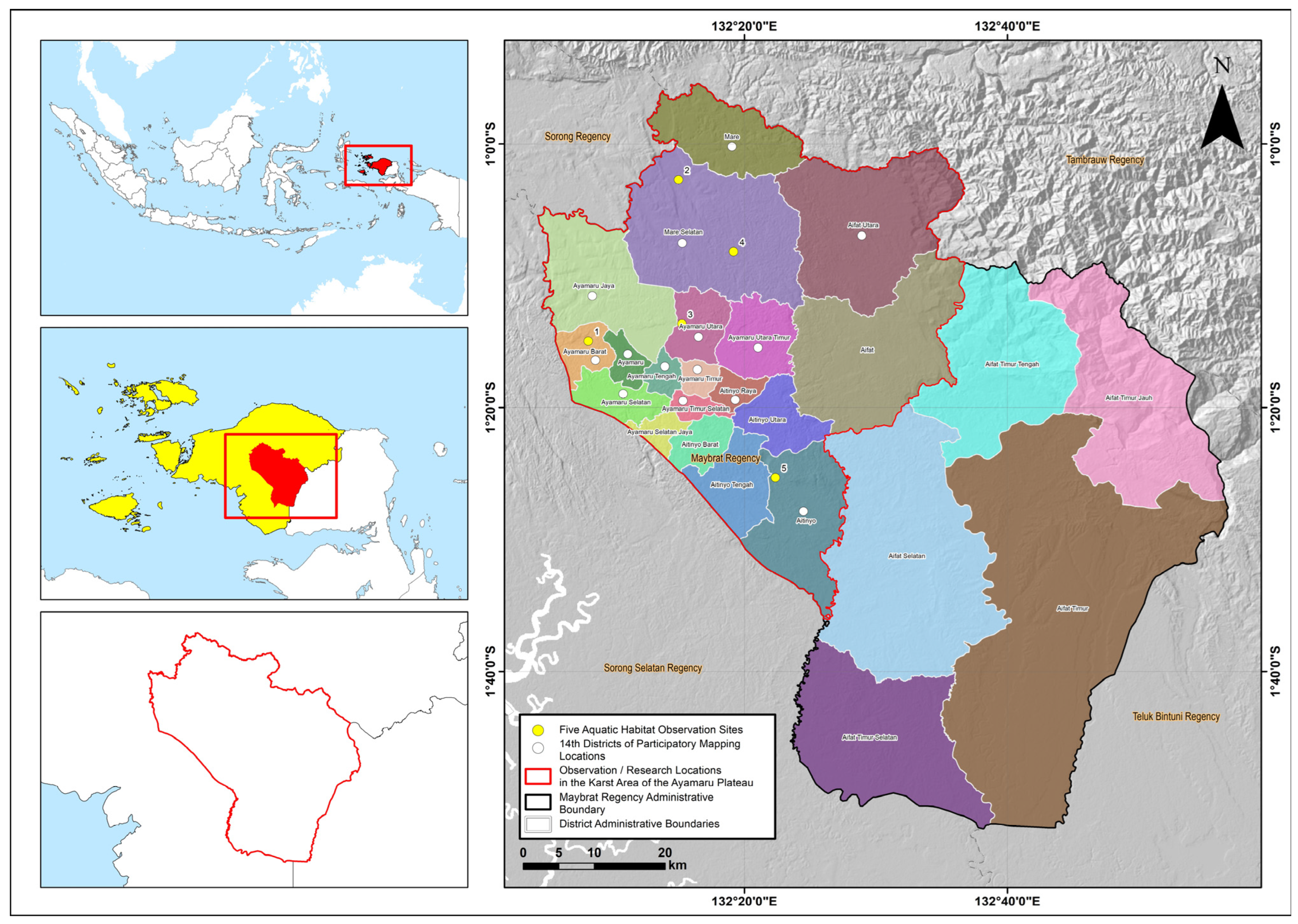
This research was conducted in Maybrat Regency, Southwest Papua Province, Indonesia. The study area covers the Maybrat Karst Region, which extends across 20 districts. Participatory mapping was conducted together with community leaders from 14 districts within the karst area, namely: Mare; South Mare; Southeast Ayamaru; South Ayamaru; Central Ayamaru; West Ayamaru; North Ayamaru; Ayamaru Jaya; East Ayamaru; Northeast Ayamaru; Ayamaru; Aitinyo; North Aifat; and Aitinyo Raya. Meanwhile, aquatic fauna observations were conducted across five aquatic habitats: the Wensi River, Yukase River, Seni River, Sua Pond, and Aitinyo Uter Lake. Site selection was based on differences in elevation and the representation of closed aquatic habitats within the karst landscape. The research location is shown in Figure 1.

2.2. Procedures

This study was carried out in three main stages: (1) the preliminary stage and determination of the research location, (2) data collection, and (3) data analysis. The first stage began with the identification of karst areas in Maybrat Regency through the interpretation of limestone lithology as the primary indicator of karst distribution. The research sites were then designated within active karst zones, covering 20 districts. The second stage, the data collection stage, involved the compilation of several datasets, including geospatial data, participatory mapping data with local communities, literature-based data on endemic aquatic fauna diversity in the Maybrat Karst Region (Vogelkop/Bird’s Head Papua), and field observation data on aquatic habitat diversity that supports the presence of native and endemic aquatic fauna. The third stage, the data analysis stage, employed two main approaches: a geospatial analysis and a descriptive ecological analysis to interpret the relationships between karst geodiversity, aquatic habitat diversity, and the presence of endemic aquatic fauna, as well as their implications for the urgency of karst conservation to ensure long-term ecosystem sustainability.

2.3. Data Collection

Data used in this study were obtained from multiple sources and through several complementary approaches to capture the complexity of the karst landscape and its associated aquatic biodiversity. These data include geospatial datasets, field-based habitat observations, aquatic fauna documentation, participatory mapping with local communities, and literature-based species records. To ensure clarity in the methodological description, the data collection procedures are organized into several subsections as follows.

2.3.1. Geospatial Data

Geospatial datasets used in this study were compiled from several authoritative sources to support the identification and delineation of karst distribution and to facilitate spatial analysis of aquatic habitats within the Maybrat Karst Region. The primary datasets consisted of geological maps of the Teminabuan and Mar sheets at a scale of 1:250,000. These geological maps were used to identify carbonate formations, particularly limestone units, which represent the principal lithology associated with karst development. Additional spatial datasets included administrative boundary maps of Maybrat Regency, protected forest area maps, and regional spatial planning maps (Rencana Tata Ruang Wilayah RTRW). These datasets were obtained from relevant government institutions and served as supporting layers for examining the spatial relationship between karst landscapes and existing land-use designations.
To enhance the interpretation of karst landforms and terrain morphology, this study incorporated high-resolution satellite imagery together with the ALOS PALSAR Digital Elevation Model (DEM), which provides a spatial resolution of 12.5 m. All spatial data were projected within the Universal Transverse Mercator coordinate system (UTM Zone 53S) using the WGS 84 datum. The integration of satellite imagery and elevation data allowed detailed visualization of geomorphological features commonly associated with tropical karst environments. Through this approach, several key karst geomorphic elements were identified, including conical karst hills, dolines, uvalas, poljes, springs, caves, and potential subterranean river pathways. These features were interpreted through a combination of terrain analysis and visual inspection of satellite imagery to identify hydrologically significant structures within the landscape.
All spatial datasets were subsequently digitized, georeferenced, and processed using Quantum Geographic Information System (QGIS) version 3.28 (https://qgis.org). Aerial data acquisition was supported using a DJI Mavic 2 Pro drone (DJI, Shenzhen, China). Limestone formations derived from geological maps were extracted and re-digitized to delineate potential karst zones within the study area. The resulting karst layer was then spatially overlaid with administrative boundary maps to define the spatial extent of the Maybrat Karst Area. Additional thematic layers, including protected forest areas and regional spatial planning zones (RTRW), were integrated through spatial overlay analysis. This process allowed an examination of how karst distribution intersects with existing conservation areas and land-use planning frameworks, thereby providing insights into the degree of formal protection afforded to the karst landscape.
To complement the geospatial analysis derived from remote sensing and geological data, field-based participatory mapping was conducted with local communities. During this process, community members identified locations of important karst features and aquatic habitats that are locally recognized within the landscape. Geographic coordinates of these features were recorded using handheld Global Positioning System (GPS) devices. The resulting coordinate data were incorporated into the geospatial database and integrated within the QGIS environment. This participatory approach enabled the verification of spatial interpretations derived from satellite imagery and DEM analysis while simultaneously enriching the dataset with locally grounded ecological knowledge.
The total extent of karst areas within Maybrat Regency was calculated using the field calculator function in QGIS by summing the surface area of all digitized limestone polygons. These values were then compared with the total administrative area of Maybrat Regency to determine the proportion of land occupied by karst formations. A similar analysis was conducted to identify the proportion of karst landscapes located within protected zones and other spatial planning designations. The resulting geospatial database formed the basis for subsequent analyses of karst geomorphology, spatial distribution of aquatic habitats, and patterns of endemic aquatic fauna within the Maybrat Karst Region.

2.3.2. Aquatic Habitat Identification

Aquatic habitat type diversity data were obtained from the interpretation of high-resolution satellite imagery combined with ALOS PALSAR Digital Elevation Model (DEM) analysis, participatory mapping with local communities, field observations, and cross-checking with the Maybrat land-cover map derived from the Regional Spatial Plan (RTRW) and relevant government agencies. Through this approach, several karst aquatic habitat types were identified, including subterranean rivers, water-filled dolines (karst ponds), karst lakes, karst swamps, cave waters, springs, and surface streams.

2.3.3. Aquatic Fauna Observation

Aquatic fauna data were obtained through field observations and documentation of individuals captured by local communities in shallow river and lake habitats within the Maybrat karst landscape. The research team did not directly collect biological specimens. Instead, observations were conducted using individuals captured by local fishers employing traditional fishing traps known locally as bubu, a passive underwater trapping device widely used in community fishing practices. This approach allowed the documentation of aquatic fauna occurring naturally within the ecosystem while minimizing disturbance to local habitats. The use of community-based fishing practices also provided an opportunity to observe species that are regularly encountered by local residents and therefore represent ecologically relevant components of the freshwater fauna within the karst system.
Field observations were conducted across five representative aquatic habitats within the Maybrat karst region: the Wensi River, Yukase River, Seni River, Sua Pond, and Aitinyo Uter Lake. These locations were selected based on their importance as traditional fishing grounds and their representation of different types of aquatic environments within the karst landscape. Rivers in this region are typically groundwater-fed systems associated with karst hydrology, whereas lakes and ponds represent surface expressions of subsurface karst water circulation. The selection of multiple habitat types allowed observations of aquatic fauna across a gradient of hydrological conditions, thereby providing insight into the ecological diversity of freshwater habitats within the Ayamaru Plateau karst system.
The objective of this study was not to conduct taxonomic revision or formal species description. Instead, the research focused on documenting morphological colour variation among individuals of the genus Cherax as a biological indicator reflecting habitat diversity and environmental differentiation within karst aquatic ecosystems. Each captured individual was visually examined and photographed in situ to document external morphological features and colour patterns. Particular attention was given to variation in carapace colouration, claw pigmentation, and overall body patterning, which are frequently associated with ecological differentiation among freshwater crayfish populations. Following documentation, the individuals were returned to the local fishers and were not retained as scientific specimens.
Species identification relied primarily on previously published taxonomic studies in which official voucher specimens had already been deposited in recognized scientific collections. These references provide the baseline framework for interpreting morphological characteristics observed in the field. Direct biological sampling in subterranean rivers or cave waters was deliberately avoided because certain underground water systems are regarded as culturally restricted or sacred areas within the customary governance system of the Maybrat Indigenous communities. Respecting these customary norms was considered essential for maintaining ethical research practices and for fostering collaborative relationships with local communities whose ecological knowledge contributes significantly to understanding karst biodiversity.

2.3.4. Participatory Mapping with Local Communities

Participatory mapping with local communities was conducted to identify and verify karst hydrological features that are not easily detected through satellite image interpretation. Community participants were asked to indicate the locations of caves, springs, karst ponds or lakes, water-filled dolines, and ponor points indicating flow into subterranean river systems on base maps derived from high-resolution satellite imagery. Information on freshwater fauna and seasonal water conditions was also recorded to complement the geospatial interpretation. The identified locations were subsequently digitized and incorporated into the spatial database using QGIS as approximate coordinate points.

2.3.5. Literature-Based Species Data

Data on endemic aquatic fauna were compiled through a literature review of journal articles, research reports, and taxonomic publications on freshwater biodiversity in the Vogelkop Peninsula (Bird’s Head Papua), which includes the Ayamaru Karst Plateau, the Maybrat River Basin, and the Ayamaru and Uter/Aitinyo lake systems in Maybrat Regency. The compiled information includes species names, endemism status, occurrence locations, and taxonomic references validated through morphological and DNA analyses supported by voucher specimens. These data complement field observations and support the assessment of the Maybrat karst landscape as a key freshwater biodiversity support system and provide a scientific basis for conservation and ecosystem sustainability.

2.4. Data Analysis

Data analysis in this study employed two main approaches: geospatial analysis and descriptive ecological analysis. Geospatial analysis was used to quantify and map the spatial characteristics of the karst landscape, including the extent of the karst area, karst hill density, and the spatial distribution of karst geodiversity elements and aquatic habitats. Descriptive ecological analysis was applied to assess karst geodiversity levels, aquatic habitat diversity, and freshwater faunal endemism, and to interpret the ecological relationships between karst geodiversity and habitat diversity in supporting the role of the Maybrat karst landscape as a center of freshwater endemism and a key support system for biodiversity, which provides the basis for determining the conservation urgency of the Maybrat karst region.

2.4.1. Geospatial Analysis

  • Karst Extent and Conservation Status
The delineation of the Maybrat Karst Area was conducted through the interpretation of geological maps of the Teminabuan and Mar sheets, which were used to identify carbonate formations representing karst-bearing lithology. Limestone units identified in these maps were extracted and re-digitized using Quantum Geographic Information System (QGIS) to generate a spatial layer representing potential karst distribution within the study area. The resulting limestone polygons were subsequently overlaid with three thematic datasets: the forestry protected area map, the protected area layer from the Regional Spatial Plan (RTRW), and the administrative boundary map of Maybrat Regency. This spatial overlay analysis enabled the delineation of the karst landscape boundary while simultaneously revealing its spatial relationship with existing conservation areas and land-use planning zones.
The total extent of karst terrain was calculated using the field calculator function in QGIS by summing the surface area of all digitized limestone polygons. These results were then compared with the total administrative area of Maybrat Regency to determine the proportion of land occupied by karst formations. A similar calculation was conducted to estimate the proportion of karst landscapes located within officially designated protected zones. By integrating geological interpretation with spatial planning datasets, this analysis provides a quantitative basis for evaluating the representation of karst ecosystems within existing conservation frameworks.
The estimation of karst hill abundance within Maybrat Regency was conducted using a plot-based sampling approach designed to characterize the morphometric structure of the tropical karst landscape. This method involved counting individual karst hills within representative sampling plots and extrapolating the results to the broader karst region. Three sampling plots measuring 1 × 1 km were purposively selected to represent the southern, central, and northern sectors of the delineated karst landscape. The selection of these plots was intended to capture potential spatial variation in karst morphology across the study area.
Within each plot, individual karst hills were manually identified and counted using high-resolution satellite imagery supported by digital elevation model (DEM) interpretation. Hill density was subsequently calculated as the number of hills per square kilometre (hills/km2). The mean hill density derived from the three plots was then used to estimate the total number of karst hills across the entire delineated karst area of Maybrat. This extrapolation provides an approximate morphometric characterization of the karst landscape, allowing the identification of hill density patterns that are typical of tropical cone karst systems.
The resulting analysis generated key geomorphological parameters describing the spatial structure of the Maybrat karst landscape, including hill density and estimated hill abundance. These morphometric indicators provide an important basis for understanding the geomorphological complexity of the region and its potential influence on hydrological processes, habitat heterogeneity, and biodiversity distribution within the karst ecosystem.
  • Accuracy Level and Margin of Error in Spatial Analysis
Spatial accuracy was maintained through geometric correction, coordinate validation, and cross-verification among high-resolution imagery, DEM data, and participatory mapping results. Overall positional accuracy was estimated at ±10–15 m, representing the margin of error in spatial positioning. Therefore, the resulting spatial values are not absolute, as they remain influenced by topographic variation, vegetation cover, image quality, and user precision during field coordinate collection.
  • Karst Geodiversity Level
Karst geodiversity refers to the diversity of surface and subsurface geomorphological features generated through the long-term dissolution of carbonate rocks. This diversity is reflected in the presence and spatial arrangement of distinctive karst landforms that collectively represent the structural and hydrological complexity of karst landscapes. In this study, karst geodiversity was assessed based on the occurrence of seven principal geomorphological elements: (1) karst hills, (2) dolines, (3) uvalas, (4) poljes, (5) permanent springs, (6) karst caves, and (7) subterranean rivers. These features encompass both exokarst components—surface landforms formed by dissolution processes—and endokarst components that develop within the subsurface drainage system. The coexistence and interaction of these geomorphological elements provide an important indicator of the degree of karstification and the maturity of karst landscape development. High geodiversity within karst systems often reflects complex interactions between lithology, hydrology, and geomorphological evolution over long geological timescales [1,2,18].
Karst hills represent one of the most prominent geomorphological features of carbonate landscapes and develop through prolonged karstification processes that progressively dissolve soluble rocks and produce distinctive topographic relief. In tropical regions, karst hills commonly occur in forms such as cone karst, tower karst, and residual limestone hills, which collectively indicate advanced stages of landscape evolution. In addition to positive relief features, karst terrains also contain a variety of closed depressions that play an important role in surface and subsurface hydrology. These depressions include dolines, uvalas, and poljes, which differ primarily in their scale and geomorphological development. Dolines are relatively small, bowl-shaped or funnel-shaped depressions formed through dissolution or collapse processes, whereas uvalas are larger depressions produced by the coalescence of several adjacent dolines. Poljes represent the largest type of karst depression and are typically characterized by extensive flat floors that may experience seasonal inundation due to groundwater fluctuations. Beyond these surface features, karst systems are also defined by endokarst structures such as permanent springs, which function as discharge points of karst aquifers; caves, which form extensive underground voids through carbonate dissolution; and subterranean rivers that transport groundwater through complex conduit networks. Together, these geomorphological and hydrological elements form an integrated karst system that supports diverse ecological habitats and regulates groundwater circulation within karst environments [1,2].
The identification criteria for each karst element used in this study guided the data collection through satellite imagery analysis, DEM analysis, participatory mapping, and field work, as detailed in Table 1.
Not all karst landscapes contain all of these elements; thus, their variation can be used to distinguish the level of karst diversity. Quantitative assessment is carried out using the Karst Diversity Index, which is the sum of the karst elements present, and is further classified into three categories: highly complex and diverse (6–7 elements), diverse (3–5 elements), and low diversity (0–2 elements).

2.4.2. Descriptive Ecological Analysis

This descriptive ecological analysis interprets how karst geodiversity and ecological functions shape aquatic habitat diversity and endemism. The approach is grounded in the Island Biogeography Theory, the Ecological and Evolutionary Refugia Concept (Davis et al., 2013; Keppel et al., 2012) [19,20] and the Ancient Lake Theory, which conceptualize karst systems as “ecological islands” and “natural laboratories of evolution” that promote isolation, population differentiation, and endemism (MacArthur & Wilson, 1967) [21]. These interpretations are supported by insights from taxonomic and molecular-genetics experts who have documented evolutionary diversification among Papua’s freshwater fauna.
  • Karst Aquatic Habitat Diversity Level
Karst aquatic habitats refer to the various types of aquatic environments formed within karst systems as a result of interactions between geomorphological, hydrological, and carbonate geological processes. These habitats include both surface and subterranean waters such as karst springs, surface rivers, subterranean rivers, karst lakes or ponds, doline pools, karst wetlands, and cave waters. These aquatic environments provide physical and ecological conditions that enable aquatic organisms to live, grow, and reproduce (Culver, D.C., & Pipan, T. 2019; Dudgeon et al., 2006; Goldscheider et al., 2020; Goldscheider & Drew, 2019) [3,5,10,22].
The diversity of karst landforms creates a wide range of hydrological conditions and distinct aquatic microhabitats. Therefore, the level of karst geodiversity plays an important role in determining the diversity of karst aquatic habitats within a landscape. The greater the complexity of karst geodiversity, the greater the variety of aquatic habitat types that develop, ultimately supporting high levels of aquatic biodiversity, including endemic species commonly found in karst ecosystems [5,10,22].
Aquatic habitat diversity was assessed using three indicators: (1) the number of aquatic habitat types present, (2) elevational variation, and (3) color or morphotype variation in Cherax spp. as a biological indicator of environmental differentiation, following established taxonomic criteria. These indicators reflect geomorphological and hydrological heterogeneity within karst systems and were classified into high, moderate, or low habitat diversity based on thresholds derived from previous studies [19,23]. Measurements for each indicator are presented in Table 2.
Habitat diversity categories: Highly diverse: ≥5 habitat types, ≥2 elevation classes, high Cherax variation, Moderately diverse: 3–4 habitat types, 1–2 elevation classes, moderate variation, Low diversity: 1–2 habitat types, uniform elevation, low variation
  • Aquatic Faunal Endemism Level
Aquatic faunal endemism was determined through a comprehensive literature-based inventory of freshwater endemic species from the Vogelkop Peninsula that have been scientifically validated by taxonomists and molecular geneticists using morphological and DNA analyses. Based on these verified species lists, endemism was classified into three Endemism Level Categories: High endemism: >8 endemic species; Moderate endemism: 5–8 endemic species; and Low endemism: <5 endemic species. These categories represent different degrees of faunal uniqueness within a karst landscape.

3. Results and Discussion

3.1. Geospatial Analysis of Karst Distribution and Conservation Coverage in Maybrat Regency

The geospatial analysis shows that Maybrat Regency covers an area of approximately ±5598.07 km2, dominated by limestone or karst formations covering ±2322.91 km2 (41.49%), while the remaining 58.51% consists of non-karst landscapes. This indicates that carbonate rocks and dissolution processes shape much of the Maybrat landscape, making it one of the most extensive karst ecosystems in Southwest Papua Province.
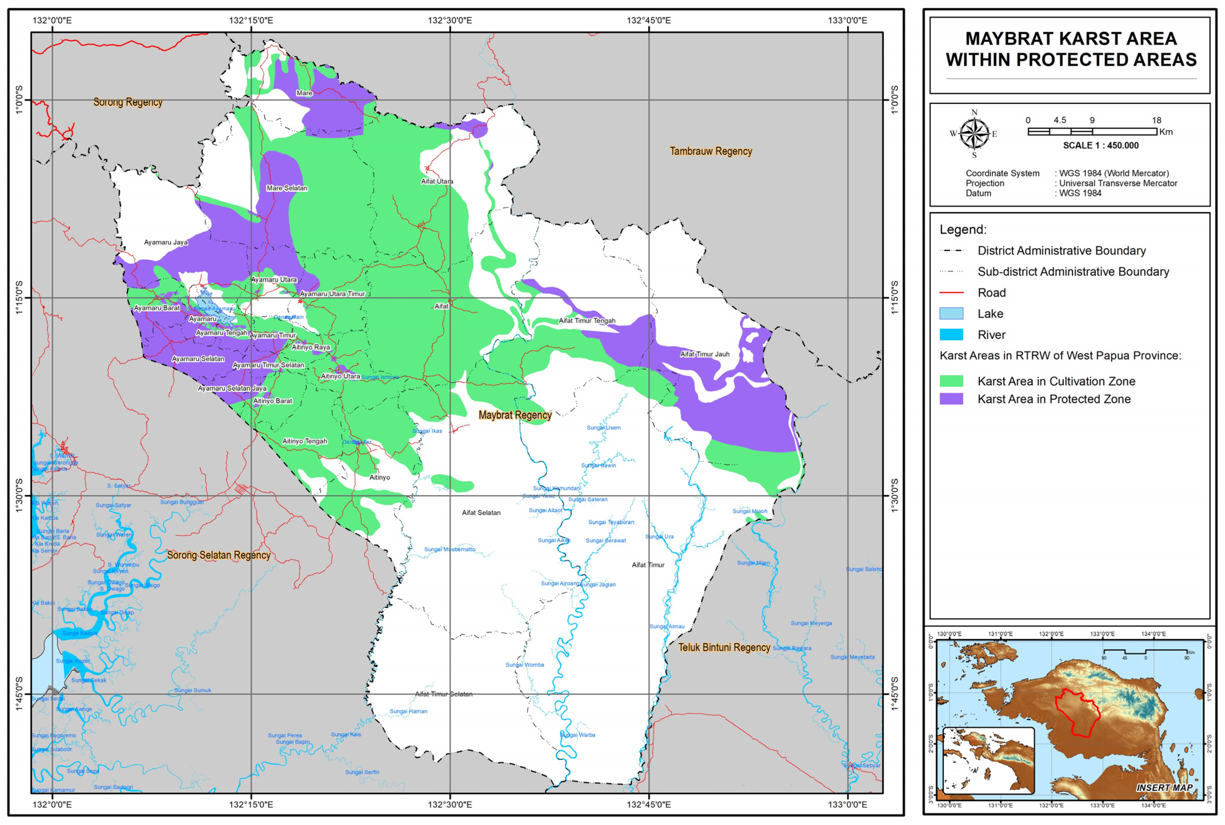
To evaluate its ecological protection status, an overlay was performed using the forest-zone map. The results, shown in that only 682.58 km2 (29.39%) of the Maybrat Karst Area lies within protected forest zones, while 1640.32 km2 (70.61%) is located outside legally protected areas (Figure 2). Consequently, most of the Maybrat Karst Landscape is vulnerable to land-use change and development pressures. This is concerning because karst regions possess exceptionally high global conservation value, yet they are often overlooked within national forest-planning frameworks, increasing the risk of degradation due to logging, mining, and land-use conversion and even threatening the biodiversity of karst ecosystems [9,11].

3.2. Karst Hills Diversity in Maybrat Karst

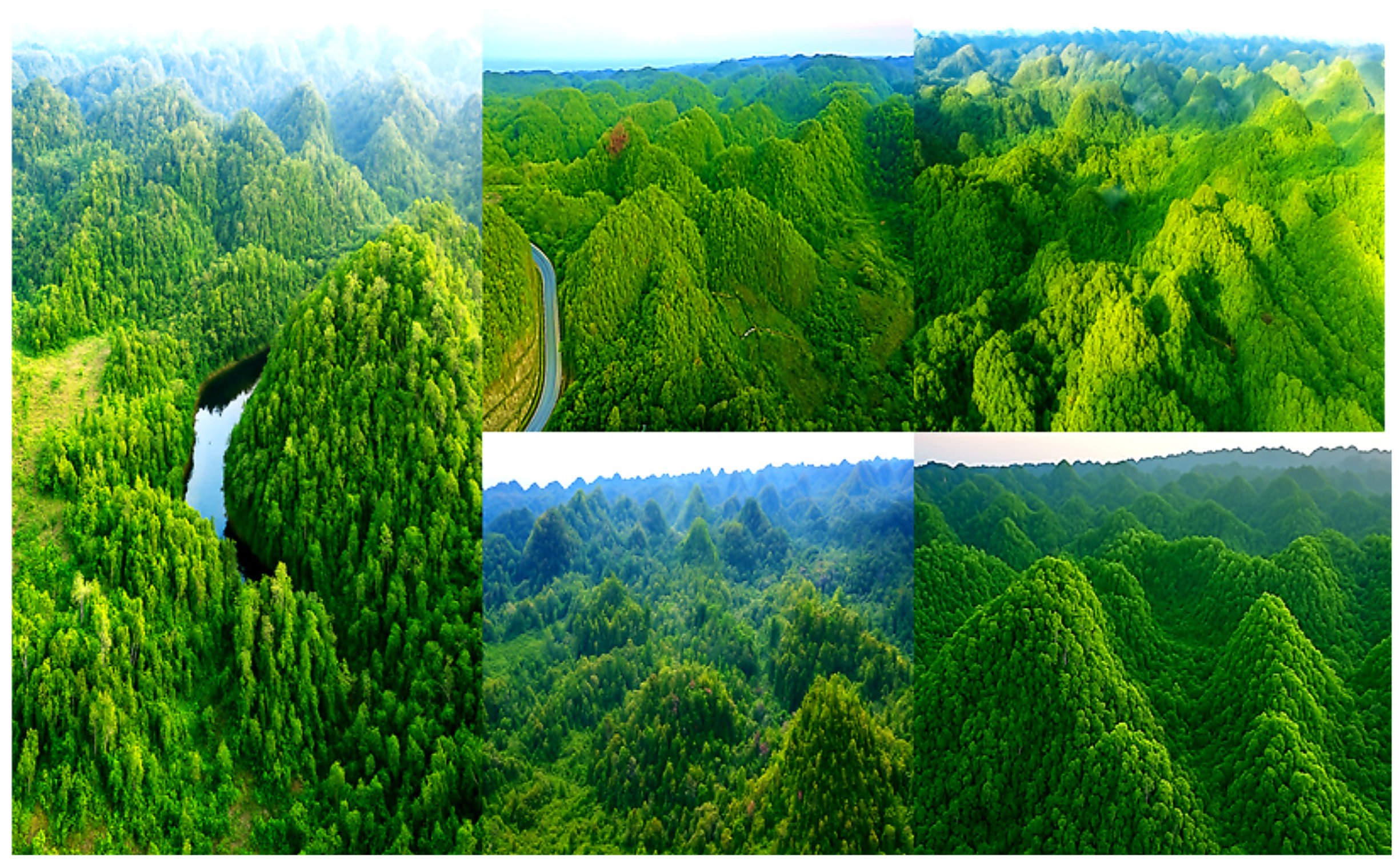
The Maybrat Karst Landscape is dominated by slender cone-karst and tower-karst hills that cluster densely and are covered by lush tropical forest (Figure 3). Plot measurements of 1 × 1 km2 across three locations recorded hill densities ranging from 40 to 56 hills/km2 (average 47 hills/km2), with approximately 54% of each plot consisting of karst hills and 45% comprising dolines and depressions, forming a highly developed exokarst mosaic. This density is higher than that of the cone karst in Gunung Sewu, Indonesia (~30 hills/km2; [27]), indicating that Maybrat Karst has one of the highest cone-karst hill densities in Indonesia and even in Southeast Asia. These results place the Maybrat Karst on par with other prominent tropical karst systems. These values exceed those of the Chocolate Hills in the Philippines (25–35 hills/km2; [28]) and the Gunung Sewu Karst (~30 hills/km2; [27]).
Morphometric analysis of 142 hills shows a dominance of small to medium-sized hills (79.5%), with relative heights of 10–80 m and slope gradients of 12–30.7%, which are characteristic of tropical cone- and tower-karst morphology. Higher hill density increases infiltration capacity and hydrostatic pressure, thereby strengthening subsurface flow and enhancing spring discharge [1,10]. Recent studies also indicate that karst morphometry and complex karst types play an important role in determining the diversity and productivity of aquatic habitats [29]. These findings confirm that the Maybrat Karst possesses highly dense and complex hill geodiversity and functions as a major recharge zone that regulates the sustainability of aquatic habitats and supports regional biodiversity.

3.3. Karst Geodiversity Level

Karst geodiversity refers to the variety of landforms produced by the dissolution of carbonate rocks, encompassing karst hills, dolines, uvalas, poljes, caves, springs, and subterranean rivers. This geomorphological diversity reflects the distinctive character of karst that differentiates it from other landscapes, while also representing highly significant geological and hydrological values [1,3].
The Maybrat Karst plays a strategic role within Indonesia’s tropical karst landscape, covering approximately 1.5% of the country’s total karst area (±154,000 km2) [12,30], and is even larger than the karst regions of Gunung Sewu (Java), Cockpit Country (Jamaica), and Mogotes (Puerto Rico). Extensive karst regions such as Maybrat generally exhibit a high degree of diversity in karst landform elements, while also creating aquatic habitat heterogeneity that supports biodiversity. The results of geospatial analysis presented in Table 3 provide strong evidence of the diversity of karst features that possess hydrological functions in supporting the regional aquatic systems of Maybrat Regency and its surroundings.
Table 3 shows that the Maybrat Karst falls into the category of “highly complex, extensive, and diverse” because it contains all major elements of karst geodiversity with a relatively even spatial distribution, as illustrated in Figure 4. This indicates an active and well-developed karst system, characterized by a complete combination of exokarst and endokarst features as well as an interconnected network of subterranean hydrology. Such geomorphic diversity reflects an advanced stage of karst evolution, important regional hydrological functions, and a high ecological capacity to support habitat diversity and endemic species.

3.4. Karst Geodiversity Supporting Aquatic Habitat Diversity

Karst geodiversity, encompassing the variety of landforms, lithologies, and geological processes, forms the basis for the emergence of highly distinctive habitats (Crofts et al., 2020) [7]. Each geomorphological unit, such as cone hills, dolines, caves, ponds, and subterranean rivers, not only fulfills hydrological functions but also creates distinct physical and chemical conditions. These differences give rise to geoecodiversity, a mosaic of habitats with unique ecological characteristics [20,23]. In this context, karst geodiversity provides the essential foundation for habitat heterogeneity, supporting elevated levels of biodiversity, including endemic species restricted to specific karst systems [6,7].

3.4.1. Water-Filled Dolines Diversity in Maybrat Karst

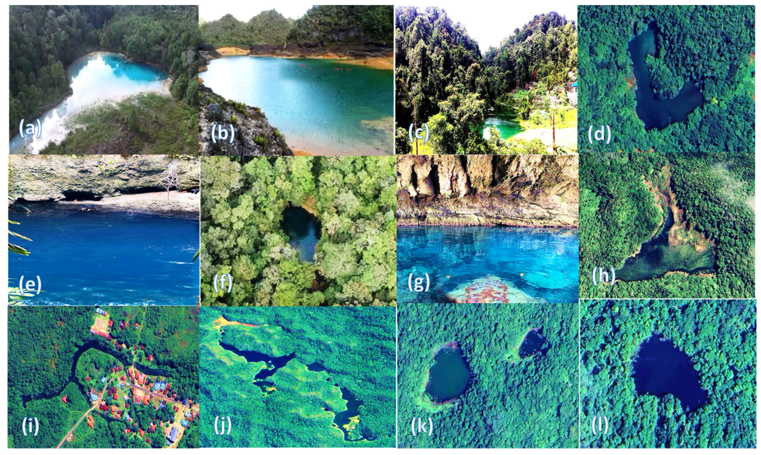
Water-filled dolines are natural closed depressions within karst landscapes formed by the dissolution of carbonate rocks and/or the collapse of subterranean cave roofs, which subsequently become filled with water either permanently or seasonally. Based on satellite image analysis, a total of 110 water-filled dolines have been identified in the Maybrat Karst Region, and field verification with local communities confirmed that all of these dolines are permanent, rarely drying up even during prolonged dry seasons. Most water-filled dolines in Maybrat are small (0.1–1 ha) and function as natural ponds or miniature lakes, while about 12 larger dolines (>1 ha), including Lake Sidi (±25 ha) serve as medium-scale natural reservoirs that form an integrated hydrological system, in which karst hills function as recharge and catchment zones, while dolines act as storage and discharge zones. These dolines are situated among densely clustered cylindrical-conical karst hills, as shown in Figure 5.
The analysis shows that water-filled dolines in the Maybrat Karst are distributed across all elevation classes. A total of 18 ponds occur at 100–200 m a.s.l., 44 ponds at 200–350 m a.s.l., and the highest number, 48 ponds, are found at 350–500 m a.s.l., mostly on the Ayamaru Plateau and higher karst hills, indicating stronger ecological isolation and greater potential for endemism. These patterns demonstrate that the Maybrat Karst encompasses a wide elevational range of habitats, from lowland karst valleys to upland plateaus, creating diverse environmental conditions that enhance habitat uniqueness and support a heterogeneous mosaic of aquatic ecosystems. Thus, water-filled dolines serve as key ecological components that support aquatic biodiversity and maintain ecological balance within the Maybrat Karst system.
This phenomenon aligns with global karst studies showing that dolines or karst ponds function as closed habitats with high endemism. For example, Telestes karsticus occurs only in karst sinkhole ponds in Croatia [31] in a seasonal karst pond in Italy [31]. In the Dinaric Karst of Southeast Europe, endemic stygofauna are restricted to specific dolines and aquifers [4]. Recent research also highlights the role of dolines as biodiversity refugia, such as in the Slovak Karst, where dolines support soil Collembola communities with higher diversity than surrounding plateaus [32]. Various research findings indicate that the geodiversity of water-filled dolines or karst ponds in Maybrat is closely related to the diversity of endemic karst-doline fauna. Each closed karst pond potentially harbors endemic aquatic species that are restricted to that specific habitat.

3.4.2. Karst Lakes (Uvala and Polje)

The Maybrat Karst Region contains three major lakes that play an important role in maintaining aquatic biodiversity, Lake Sidi (1.35 km; 25.36 ha; ~480 m a.s.l.), Lake Ayamaru (19.33 km; 980 ha; ~250 m a.s.l.), and Lake Uter (5.54 km; 55 ha; ~175 m a.s.l.). These lakes form a tiered lacustrine system with variations in size, depth, and water chemistry, creating unique physicochemical conditions essential for ecosystem differentiation [19]. Geologically, the lakes of the Ayamaru Plateau developed on Miocene limestone (23–5 Ma) uplifted by Neogene–Quaternary tectonic processes, forming closed karst depressions on an ancient carbonate foundation that has undergone intensive karstification [13,15].
Long-term karstification and tectonic activity have produced ancient, isolated ecosystems that restrict genetic exchange with external water systems, enabling local speciation and genetic differentiation among aquatic populations, making these lakes ideal environments for adaptive evolution and endemism [19,20]. Similar phenomena have been reported in ancient karst lake systems worldwide, such as Lake Ohrid in the Balkans, Lake Skadar in Montenegro, Albania, and Red Lake in Croatia, all of which exhibit high levels of endemism among fish, mollusks, and stygofauna resulting from long-term evolutionary isolation [33,34]. Thus, the karst habitats of Maybrat, formed upon an ancient carbonate foundation and geographically isolated, can be regarded as a “natural evolutionary laboratory” supporting the development of endemic aquatic biodiversity with global conservation significance.

3.4.3. Karst Springs Diversity

This study identified 334 perennial springs in the Maybrat Karst, consisting of 142 river springs, 156 pool/lake springs, and 36 cave springs, most of which are outlets of subterranean rivers that briefly emerge at the surface before re-entering the subsurface through ponors. Their high discharge produces exceptionally clear flows, including two vertical-flow springs at Sron and Seni located along local fault zones. The elevational distribution of springs shows that all classes are represented, 200–350 m (161 springs), 350–500 m (143 springs), and 100–200 m (28 springs), indicating high vertical habitat diversity from karst valleys to the Ayamaru Plateau and highlighting the role of mid- to high-elevation hills as the most active recharge and discharge zones. The persistence of spring flow is supported by dense karst hills, extensive primary forest cover, and a stable humid tropical climate, demonstrating that the Maybrat Karst functions primarily as a hydrological system sustaining aquatic ecosystems.
Recent studies also show that karst springs are important habitats for fauna that depend on clear and stable flows, as demonstrated by [35] for freshwater biodiversity refugia and by [29], who found that springs are evolutionarily significant habitats supporting endemic and relict species with low dispersal abilities, particularly mollusks and small crustaceans. Meanwhile, according to [19], the hydrological stability of springs allows long-term isolation, promoting genetic differentiation and the formation of new species. Thus, the diversity of springs in the Maybrat Karst reflects habitat heterogeneity that supports endemic aquatic fauna while reinforcing the strong linkage between karst spring geodiversity and aquatic biodiversity.

3.4.4. The Subterranean River System of the Maybrat Karst

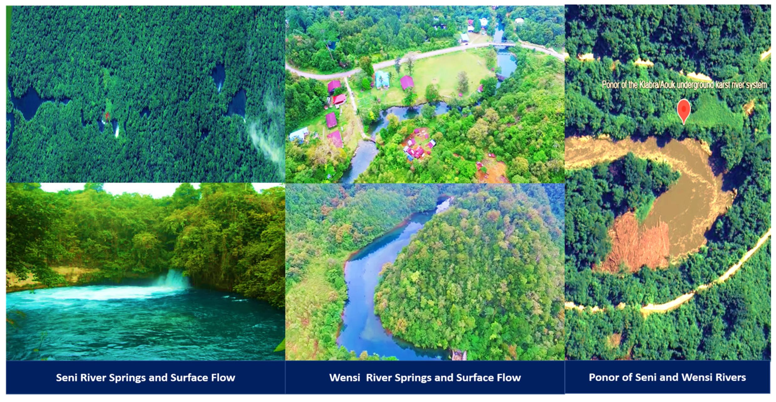
Subterranean rivers are key components of karst ecosystems, creating strong ecological isolation that promotes high biodiversity and endemism. The identification of 178 springs with ponors functioning as subsurface flow conduits indicates an extensive, enclosed, and interconnected underground drainage network that limits hydrological connectivity and gene flow. The characteristic conditions of subterranean flow, perpetual darkness, thermal stability, low energy availability, and confined pathways—produce species with extremely restricted distributions [6,19]. Microhabitat heterogeneity further accelerates adaptive divergence and generates specialist fauna, as comprehensively described by [5] in their work on subterranean evolution and biodiversity. Thus, the dominance of subterranean rivers in the Maybrat Karst is likely to reinforce ecological isolation, genetic differentiation, and local speciation, underscoring its significant evolutionary and conservation value. Two examples of subterranean river systems in the Maybrat Karst Region are shown in Figure 6.
A spectacular study by the Acheloos Geo Exploring Expedition (2017–2018), as reported by Benassi and Pasquini [36], revealed a giant underground river cave system in the Aouk River within the Maybrat Karst region. The system contains more than 6 km of mapped cave passages, with chambers exceeding 100 m in height and approximately 40 m in width, and an average discharge of about 50 m3/s, making it one of the largest river caves in the tropical karst regions. Visual documentation of this cave exploration is available online https://darknessbelow.co.uk/news-exploring-large-river-caves-in-west-papua/ (accessed on 20 February 2026) [37]. This discovery further highlights the global geological and hydrological significance of the Maybrat Karst and supports the urgent need for its conservation.

3.5. Aquatic Habitat Diversity and Endemism Potential in the Maybrat Karst Region

Aquatic habitat diversity was assessed using three indicators: (1) the number of aquatic habitat types present, (2) elevational variation, and (3) color or morphotype variation in Cherax spp. as a biological indicator of environmental differentiation, following established taxonomic criteria. The identification results show that the Maybrat Karst exhibits a high level of habitat diversity across these three indicators, which strongly supports the potential for endemic aquatic fauna within the system. The full assessment results are presented in Table 4.
The results in Table 4 show that the three indicators of aquatic habitat diversity, habitat type, elevational range, and Cherax morphotype variation, collectively reflect the very high geodiversity of the Maybrat Karst. This condition is directly linked to the high levels of endemism and aquatic biodiversity generated by its complex karst system. Furthermore, because its hydrological system and habitat network extend into South Sorong and Sorong Regencies, the area holds strategic conservation importance at the regional scale. Therefore, the protection of the Maybrat Karst should be positioned as a regional conservation priority with global significance.
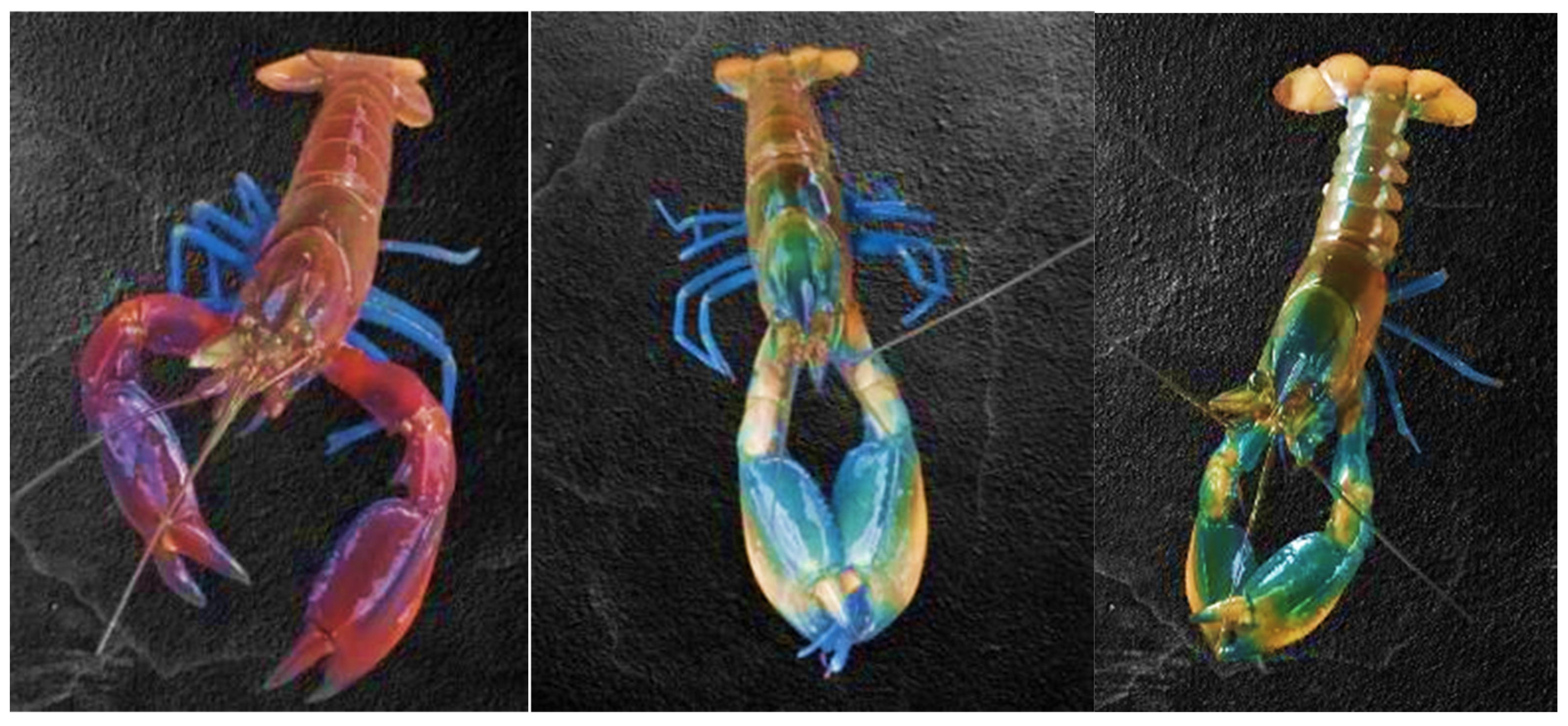
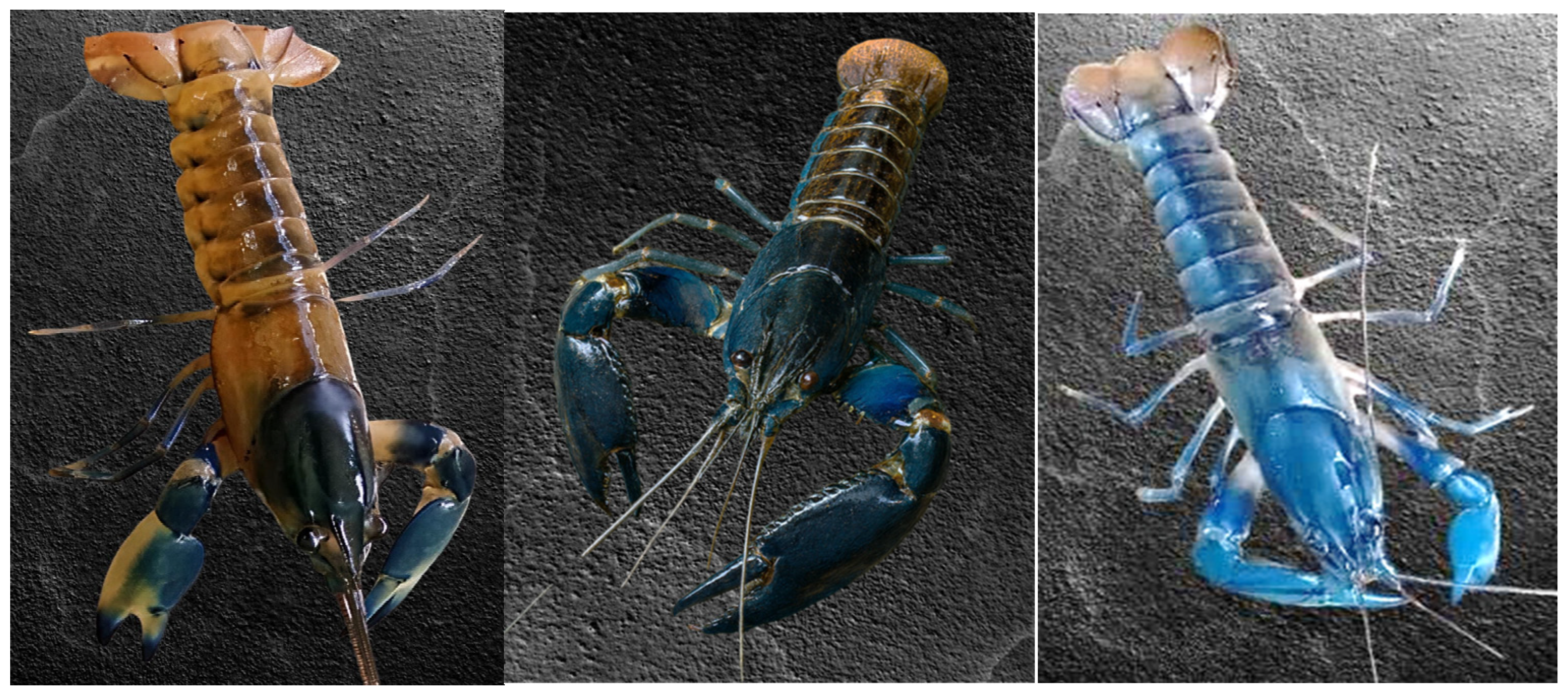
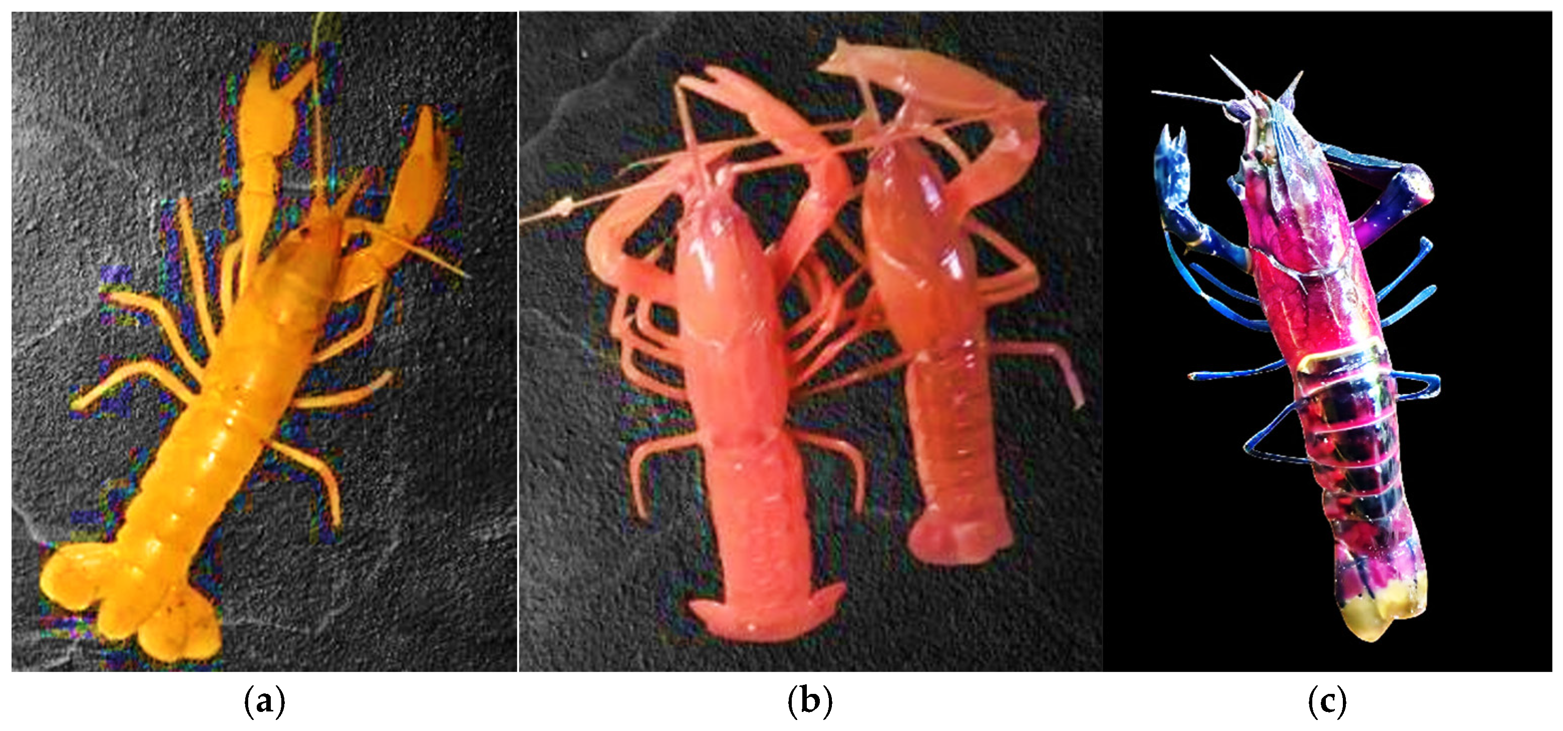
Observations of Cherax spp. color variation across five habitats in the Maybrat Karst reveal 17 distinct morphotypes, indicating strong environmental differentiation and potential ecological isolation among habitats. The highest variation was recorded in the Wensi River, which contained five unique morphotypes. Detailed color variations for each habitat are presented in Table 5, and representative samples are shown in Figure 7, Figure 8 and Figure 9.
The results reveal remarkable variation in color morphotypes among Cherax sp. populations across multiple karst habitats. Some morphotypes resemble previously described species such as Cherax boesemani, C. holthuisi, and C. phing, whereas others exhibit distinctive pigmentation patterns that have not been previously documented. These variations suggest population differentiation potentially driven by habitat heterogeneity and hydrological isolation within the karst landscape.
Karst environments are characterized by complex hydrogeological systems that generate diverse aquatic habitats, including springs, subterranean rivers, lakes, and isolated surface streams. Such systems often exhibit strong spatial fragmentation because groundwater flow pathways, sinkholes, and closed depressions create hydrologically separated environments [1,3]. These conditions can function as ecological islands, where aquatic habitats become isolated units that limit dispersal and gene flow among populations.
According to the Island Biogeography Theory, habitat isolation combined with environmental heterogeneity can promote evolutionary divergence and increase the probability of local endemism [21]. In karst landscapes, this process is particularly pronounced because hydrological fragmentation creates numerous microhabitats that may support genetically differentiated populations [5]. Such conditions are widely recognized as key drivers of biodiversity patterns in subterranean and karst-associated ecosystems.
This pattern is evident in the populations from Sua Lake and the Wensi River, which display distinctive color morphotypes compared with other sampling locations. Both habitats occur within hydrologically constrained karst environments and may experience limited connectivity with surrounding aquatic systems. The isolation of these habitats may promote local adaptation and morphological differentiation within Cherax populations. Similar patterns of diversification driven by habitat fragmentation have been reported in many karst ecosystems worldwide, where isolated aquatic systems frequently harbor endemic or narrowly distributed taxa [5,38].
Therefore, the combination of habitat diversity, hydrological isolation, and environmental heterogeneity within the Maybrat karst likely promotes population divergence and increases the potential for aquatic endemism. These findings support the widely recognized view that karst landscapes often function as biodiversity and endemism hotspots, as their geomorphological complexity and fragmented hydrological systems generate numerous ecologically isolated habitats.
Although tentative identifications have been proposed, the presence of several unique color morphotypes highlights the need for integrative taxonomic research combining morphological observations with molecular analyses. Without genetic confirmation, it remains uncertain whether these variations represent intraspecific color polymorphism or the presence of distinct species. Nevertheless, the occurrence of such morphotypes underscores the importance of conserving the entire Maybrat karst landscape as a single interconnected ecosystem, because each component—habitat, rivers, lakes, dolines, and springs—contributes to the maintenance and evolution of aquatic biodiversity.

3.6. Aquatic Endemism Level in the Maybrat Karst Region

Aquatic endemism in this study refers to freshwater species that have been validated as endemic through taxonomic and molecular genetic analyses. Endemic status is categorized into three groups: (1) Maybrat Endemic, referring to species found within the administrative boundaries of Maybrat Regency; (2) Ayamaru Karst Plateau Endemic, referring to species occurring in the karst region of the Ayamaru Plateau but outside the administrative jurisdiction of Maybrat; and (3) Maybrat Watershed Endemic, referring to species found outside Maybrat Regency yet located within a watershed hydrologically connected to Maybrat. Maybrat Regency encompasses seven major watersheds: Kais, Kelabra, Kamundan, Sekak, Waromge, Weriagar, and Sebiar.
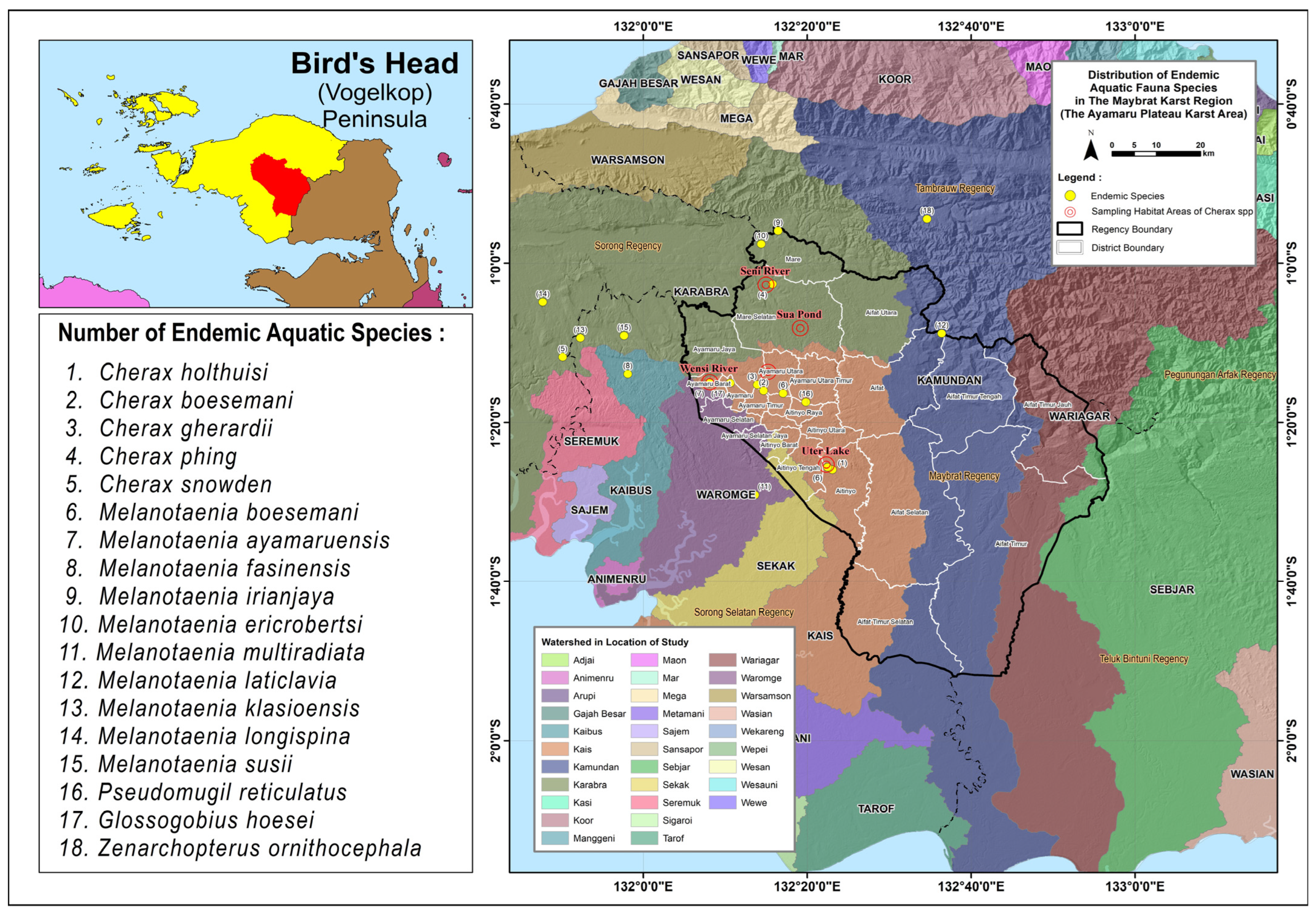
This study identified 18 endemic aquatic species, predominantly from the genera Melanotaenia spp. and Cherax spp., representing the highest number of endemic taxa ever recorded in the region. Of the total species documented, 11 are native endemics of Maybrat, while seven species occur outside Maybrat but belong to the same Ayamaru Karst Plateau system and share hydrological connectivity with the Maybrat watershed. These findings demonstrate that aquatic endemism in Maybrat Regency is remarkably high, highlighting the strong linkage between karst geodiversity, hydrological isolation, and habitat heterogeneity in supporting biodiversity and endemic species richness. The potential number of endemic species is likely to increase, as many closed karst habitats have not yet been fully evaluated for their endemic status.
The 18 endemic species identified in this study are presented in detail in Table 6, while their distribution patterns based on natural habitats, defined here as the locations where species were recorded and field sampling was conducted are shown in Figure 10.
The discovery of 18 endemic aquatic fauna species in the Maybrat Karst indicates a high level of aquatic endemism and highlights the region as an important center of biodiversity within the karst landscapes of Papua. This high level of endemism is closely linked to the complex geodiversity of the karst system, which includes variations in lithology, carbonate rock structure, degrees of karstification, and diverse landforms such as karst hills, dolines, springs, and subterranean rivers. Such geodiversity shapes the hydrological architecture of the karst landscape and generates a wide range of aquatic habitats.
In karst ecosystems, geodiversity acts as a fundamental driver controlling hydrological processes and landscape structure, thereby creating diverse environmental conditions across different geomorphological units [1,38]. These variations produce a mosaic of habitats, including springs, water-filled dolines, karst lakes, and subterranean rivers, many of which are ecologically isolated. Habitat heterogeneity of this kind provides a wide range of ecological niches and supports the differentiation of aquatic communities.
Moreover, the naturally fragmented hydrological systems typical of karst environments often restrict organism dispersal and reduce gene flow among populations, promoting evolutionary divergence and the formation of endemic species [5]. Consequently, karst regions worldwide are widely recognized as hotspots of endemism, particularly for aquatic and subterranean fauna.
In this context, the Maybrat Karst represents a highly significant landscape for biodiversity conservation, where high geodiversity has generated diverse and hydrologically structured aquatic habitats that support numerous endemic species. These findings emphasize that the Maybrat Karst functions not only as a geomorphologically and hydrologically important system but also as a critical ecological support system for aquatic biodiversity, underscoring the urgent need for comprehensive conservation of the karst ecosystem to sustain its high levels of endemism and biological diversity.

3.7. Urgency of Conservation for the Maybrat Karst Region in a Regional and Global Context

The ecological configuration of the Maybrat Karst demonstrates that the region cannot be conserved through partial or sectoral approaches. All of its components, surface landforms, subterranean conduits, hydrological pathways, and microhabitats, function as a single integrated hydrogeological system. Disturbance to any element affects the entire network: degradation of cone karst hills alters infiltration, sedimentation disrupts ponor function, and changes in subterranean flow reduce spring discharge and water quality, threatening endemic species with extremely narrow ecological tolerances. Therefore, protecting only springs, caves, or segments of surface rivers is insufficient to maintain the ecological and evolutionary integrity of the karst system.
This challenge is further compounded by a clear regulatory gap. National policies such as the Karst Landscape Protection Regulation (Permen ESDM 17/2012) and the Essential Ecosystem Area policy (Permen LHK P.76/2019) do not comprehensively cover the Maybrat Karst, particularly areas outside formal conservation zones. Of Maybrat’s total administrative area of 559,806.94 ha, only 12.2% (±68,258.46 ha) is designated as conservation land. Specifically within the karst landscape, only 29.39% (68,258.46 ha) is protected, while 70.61% (164,032.46 ha) lacks legal protection despite containing critical geomorphological and hydrological units essential for biodiversity persistence.
Taken together, the strong interdependence between geodiversity, habitat diversity, and high levels of endemism, combined with regulatory gaps and the transboundary nature of the Ayamaru Plateau, demonstrates that cross-district, whole-ecosystem conservation is the only viable strategy to sustain the hydrological, ecological, and evolutionary functions of the Maybrat Karst. Its ecological uniqueness, high endemism, and intact geomorphology position the region as a strong candidate for national–regional conservation designation and a potential nomination for the UNESCO Global Geopark framework. Without holistic protection, the Maybrat Karst risks the same trajectory observed in many karst systems worldwide, where endemic species disappeared before they were scientifically documented.

4. Conclusions

The Maybrat Karst constitutes a highly complex karst system characterized by a complete diversity of karst landforms with dense and relatively even spatial distribution, forming an integrated hydrological system that functions as a water tower, supports diverse aquatic habitats, and provides enclosed environments for the adaptation and evolution of endemic species, thereby sustaining regional biodiversity. Despite these critical ecological and hydrological functions, formal protection of the Maybrat Karst remains limited, with only a small proportion of both the administrative area and the karst landscape legally designated as conservation land, leaving most high-value geomorphological and hydrological units unprotected and placing the Maybrat Karst in an urgent conservation status.

Author Contributions

A.E.P.T. contributed to conceptualization, methodology, investigation, formal analysis, data curation, visualization, and writing the original draft of the manuscript, as well as manuscript review and editing. H.S.A. contributed to conceptualization, supervision, validation, project administration, funding acquisition, and manuscript writing, review, and editing, and served as the corresponding author. R.M. contributed to supervision, validation, and manuscript review and editing. S.M. contributed to supervision, validation, and manuscript review and editing. All authors have read and agreed to the published version of the manuscript.

Funding

This research received no external funding.

Institutional Review Board Statement

Not applicable.

Informed Consent Statement

Not applicable.

Data Availability Statement

The data presented in this study are available within the article and from the corresponding author upon reasonable request.

Acknowledgments

The authors thank the Government of Southwest Papua Province and the Government of Maybrat Regency for their support during the field research. The authors also acknowledge the local communities in Ayamaru, Aitinyo, Aifat, and Mare for their valuable information during field surveys, as well as previous researchers on endemic freshwater species in the Maybrat region whose literature supported this study. During the preparation of this manuscript, the authors used ChatGPT 5.3 (OpenAI) for language editing and grammar improvement. The authors reviewed and edited the output and take full responsibility for the content of this publication.

Conflicts of Interest

The authors declare no conflicts of interest.

References

  1. Ford, D.; Williams, P. Karst Hydrogeology and Geomorphology; Wiley: Chichester, UK, 2007. [Google Scholar]
  2. Veress, M. Karst Types and Their Karstification. J. Earth Sci. 2020, 31, 621–634. [Google Scholar] [CrossRef]
  3. Goldscheider, N.; Chen, Z.; Auler, A.S.; Bakalowicz, M.; Broda, S.; Drew, D.; Hartmann, J.; Jiang, G.; Moosdorf, N.; Stevanovic, Z.; et al. Global Distribution of Carbonate Rocks and Karst Water Resources. Hydrogeol. J. 2020, 28, 1661–1677. [Google Scholar] [CrossRef]
  4. Stevanovic, Z. Karst Waters in Potable Water Supply: A Global Scale Overview. Environ. Earth Sci. 2019, 78, 662. [Google Scholar] [CrossRef]
  5. Culver, D.C.; Pipan, T. The Biology of Caves and Other Subterranean Habitats, 2nd ed.; Oxford University Press: Oxford, UK, 2019. [Google Scholar]
  6. Deharveng, L.; Bedos, A.; Pipan, T.; Culver, D.C. Global Subterranean Biodiversity: A Unique Pattern. Diversity 2024, 16, 157. [Google Scholar] [CrossRef]
  7. Crofts, R.; Gordon, J.E.; Brilha, J.; Gray, M.; Gunn, J.; Larwood, J.; Santucci, V.L.; Tormey, D.; Worboys, G.L. Guidelines for Geoconservation in Protected and Conserved Areas; IUCN: Gland, Switzerland, 2020.
  8. Zhang, Z.; Xiong, K.; Chang, H.; Zhang, W.; Huang, D. A Review of Eco-Product Value Realization and Ecological Civilization and Its Enlightenment to Karst Protected Areas. Int. J. Environ. Res. Public Health 2022, 19, 5892. [Google Scholar] [CrossRef]
  9. Sulistiyowati, E.; Setiadi; Haryono, E. Karst and Conservation Research in Indonesia and Its Implication to Education. J. Phys. Conf. Ser. 2021, 1796, 012071. [Google Scholar] [CrossRef]
  10. Goldscheider, N.; Drew, D. Methods in Karst Hydrogeology: IAH—International Contributions to Hydrogeology, 26, 1st ed.; CRC Press: Boca Raton, FL, USA, 2019. [Google Scholar]
  11. Widyaningsih, G.A. Permasalahan Hukum Dalam Perlindungan Ekosistem Karst Di Indonesia (Studi Kasus: Ekosistem Karst Sangkulirang–Mangkalihat, Provinsi Kalimantan Timur). J. Huk. Lingkung. 2017, 3, 1–24. [Google Scholar] [CrossRef]
  12. Aprilia, D.; Arifiani, K.N.; Sani, M.F.; Jumari; Wijayanti, F.; Setyawan, A.D. A Descriptive Study of Karst Conditions and Problems in Indonesia and the Role of Karst for Flora, Fauna, and Humans. Int. J. Trop. Drylands 2021, 5, 61–74. [Google Scholar] [CrossRef]
  13. Kartikasari, S.N.; Marshall, A.J.; Beehler, B.M. Ekologi Papua; Yayasan Obor: Jakarta, Indonesia, 2012. [Google Scholar]
  14. Hamilton, W.B. Tectonics of the Indonesian Region; U.S. Government Printing Office: Washington, DC, USA, 1979.
  15. Pigram, C.J.; Panggabean, H. Rifting of the Northern Margin of the Australian Continent and the Origin of Some Microcontinents in Eastern Indonesia. Tectonophysics 1984, 107, 331–353. [Google Scholar] [CrossRef]
  16. Lukhaup, C.; Panteleit, J.; Schrimpf, A. Cherax Snowden, a New Species of Crayfish (Crustacea, Decapoda, Parastacidae) from the Kepala Burung (Vogelkop) Peninsula in Irian Jaya (West Papua), Indonesia. ZooKeys 2015, 518, 1–14. [Google Scholar] [CrossRef]
  17. Lukhaup, C.; Erpilorahman, R.; von Rintelen, T. Two New Species of Crayfish of the Genus Cherax (Crustacea: Decapoda: Parastacidae) from Western and Eastern Indonesian New Guinea. Arthropoda 2024, 2, 264–293. [Google Scholar] [CrossRef]
  18. Zerga, B. Karst Topography: Formation, Processes, Characteristics, Landforms, Degradation and Restoration: A Systematic Review. Watershed Ecol. Environ. 2024, 6, 252–269. [Google Scholar] [CrossRef]
  19. Davis, J.; Pavlova, A.; Thompson, R.; Sunnucks, P. Evolutionary Refugia and Ecological Refuges: Key Concepts for Conserving Australian Arid Zone Freshwater Biodiversity under Climate Change. Glob. Change Biol. 2013, 19, 1970–1984. [Google Scholar] [CrossRef] [PubMed]
  20. Keppel, G.; Van Niel, K.P.; Wardell-Johnson, G.W. Refugia: Identifying and Understanding Safe Havens for Biodiversity under Climate Change. Glob. Ecol. Biogeogr. 2012, 21, 393–404. [Google Scholar] [CrossRef]
  21. MacArthur, R.H.; Wilson, E.O. The Theory of Island Biogeography; Princeton University Press: Princeton, NJ, USA, 1967. [Google Scholar]
  22. Dudgeon, D.; Arthington, A.H.; Gessner, M.O.; Kawabata, Z.-I.; Knowler, D.J.; Lévêque, C.; Naiman, R.J.; Prieur-Richard, A.-H.; Soto, D.; Stiassny, M.L.J.; et al. Freshwater Biodiversity: Importance, Threats, Status and Conservation Challenges. Biol. Rev. 2006, 81, 163–182. [Google Scholar] [CrossRef] [PubMed]
  23. Sacco, M.; Mammola, S.; Altermatt, F.; Bolpagni, R. Groundwater Is a Hidden Global Keystone Ecosystem. Glob. Change Biol. 2023, 30, e17066. [Google Scholar] [CrossRef]
  24. Geospatial Information Agency (BIG). Indonesian Topographic Map (RBI), Scale 1:50,000, West Papua and Southwest Papua Provinces; BIG: Bogor, Indonesia, 2022.
  25. Government of West Papua Province. Regional Regulation No. 3 of 2022 concerning the Regional Spatial Plan (RTRW) of West Papua Province 2022–2041; Government of West Papua Province: Manokwari, Indonesia, 2022.
  26. Geological Research and Development Centre. Geological Map of Teminabuan and Mar Sheets, Scale 1:250,000; GRDC: Bandung, Indonesia, 1989.
  27. Haryono, E.; Day, M. Landform Differentiation within the Gunung Kidul Kegelkarst, Java, Indonesia. J. Cave Karst Stud. 2004, 66, 62–69. [Google Scholar]
  28. Salomon, J.-N. A Mysterious Karst: The Chocolate Hills of Bohol (Philippines). Acta Carsologica 2011, 40, 429–444. [Google Scholar] [CrossRef]
  29. Swedberg, D.A.; Mollenhauer, R.; Brewer, S.K. The Context Dependency of Fish–Habitat Associations in Separated Karst Ecoregions. Ecol. Evol. 2023, 13, e10701. [Google Scholar] [CrossRef]
  30. Persada, A.Y.; Rahmadi, M.T.; Suciani, A. Pole Level Mangrove Analysis as a Conservation Effort of the Coastal Mangrove Forest of Langsa City. Adv. Soc. Sci. Educ. Humanit. Res. 2021. [Google Scholar] [CrossRef]
  31. Carosi, A.; Barelli, M.G.; Ambrosi, A.; Rossetti, A.; Morandi, F.; Lorenzoni, F.; Tagliaferri, G.; Lorenzoni, M. Population Status and Ecology of the Steno-Endemic Fairy Shrimp Chirocephalus Sibyllae Cottarelli and Mura, 1975 Inhabiting a Mountain Temporary Pond (Central Italy). Water 2022, 14, 1750. [Google Scholar] [CrossRef]
  32. Marcin, M.; Raschmanova, N.; Miklisova, D.; Supinsky, J.; Kanuk, J.; Kovac, L. Karst Dolines Support Highly Diversified Soil Collembola Communities—Possible Refugia in a Warming Climate? Diversity 2022, 14, 1037. [Google Scholar] [CrossRef]
  33. Albrecht, C.; Wilke, T. Ancient Lake Ohrid: Biodiversity and Evolution. Hydrobiologia 2008, 615, 103–140. [Google Scholar] [CrossRef]
  34. Wilke, T.; Hauffe, T.; Jovanovska, E.; Cvetkoska, A. Deep Drilling Reveals Massive Shifts in Evolutionary Dynamics after Formation of Ancient Ecosystem. Sci. Adv. 2020, 6, eabb2943. [Google Scholar] [CrossRef]
  35. Fernandez-Martinez, M.; Barquin, J.; Bonada, N. Mediterranean Springs: Keystone Ecosystems and Biodiversity Refugia Threatened by Global Change. Glob. Change Biol. 2023, 29, 16997. [Google Scholar] [CrossRef]
  36. Benassi, A.; Pasquini, T. Auk Underground River. Speleologia 2018, 79, 39–44. [Google Scholar]
  37. Darkness Below. Exploring Large River Caves in West Papua. Available online: https://darknessbelow.co.uk/news-exploring-large-river-caves-in-west-papua/ (accessed on 20 February 2026).
  38. Gray, M. Geodiversity: Valuing and Conserving Abiotic Nature, 2nd ed.; Wiley-Blackwell: Chichester, UK, 2013. [Google Scholar]
  39. Lukhaup, C.; Pekny, R. Cherax (Cherax) Holthuisi, a New Species of Crayfish (Crustacea: Decapoda: Parastacidae) from the Centre of the Vogelkop Peninsula in Irian Jaya (West New Guinea), Indonesia. Zool. Meded. Leiden 2006, 80, 101–108. [Google Scholar]
  40. Lukhaup, C.; Pekny, R. Cherax (Astaconephrops) Boesemani, a New Species of Crayfish (Crustacea: Decapoda: Parastacidae) from the Centre of the Vogelkop Peninsula in Irian Jaya (West New Guinea), Indonesia. Zool. Meded. Leiden 2008, 82, 331–340. [Google Scholar]
  41. Patoka, J.; Blaha, M.; Kouba, A. Cherax (Astaconephrops) Gherardii, a New Crayfish (Decapoda: Parastacidae) from West Papua, Indonesia. Zootaxa 2015, 3964, 526–536. [Google Scholar] [CrossRef]
  42. Allen, G.R.; Cross, N.J. Descriptions of Five New Rainbowfishes (Melanotaeniidae) from New Guinea. Rec. West. Aust. Mus. 1980, 8, 377–396. [Google Scholar]
  43. Kadarusman; Sudarto; Paradis, E.; Pouyaud, L. Description of Melanotaenia Fasinensis, a New Species of Rainbowfish (Melanotaeniidae) from West Papua, Indonesia with Comments on the Rediscovery of M. ajamaruensis and the Endangered Status of M. parva. Cybium 2010, 34, 207–215. [Google Scholar]
  44. Allen, G.R. Three New Rainbowfishes (Melanotaeniidae) from Irian Jaya and Papua New Guinea. Rec. West. Aust. Mus. 1985, 12, 53–62. [Google Scholar]
  45. Allen, G.R.; Unmack, P.J.; Hadiaty, R.K. Three New Species of Rainbowfishes (Melanotaeniidae) from the Birds Head Peninsula, West Papua Province, Indonesia. Aqua Int. J. Ichthyol. 2014, 20, 1–20. [Google Scholar]
  46. Nugraha, M.F.I.; Kadarusman; Hubert, N.; Avarre, J.-C.; Hadiaty, R.K.; Slembrouck, J.; Carman, O.; Sudarto; Ogisitra, R.; Pouyaud, L. Eight New Species of Rainbowfishes (Melanotaeniidae) from the Birds Head Region, West Papua, Indonesia. Cybium 2015, 39, 99–130. [Google Scholar]
  47. Allen, G.R.; Boeseman, M. A Collection of Freshwater Fishes from Western New Guinea with Descriptions of Two New Species (Gobiidae and Eleotridae). Rec. West. Aust. Mus. 1982, 10, 67–103. [Google Scholar]
  48. Collette, B.B. Zenarchopterus Ornithocephala, a New Species of Freshwater Halfbeak (Pisces: Hemiramphidae) from the Vogelkop Peninsula of New Guinea. Proc. Biol. Soc. Wash. 1985, 98, 107–111. [Google Scholar]
Figure 1. Map of Maybrat Regency, Southwest Papua Province, Indonesia. The study area is indicated by a red outline.
Sustainability 18 03287 g001
Figure 2. Spatial Distribution of the Maybrat Karst Area and Extent within Protected Forest Zones. Data sources: Indonesian Topographic Map (RBI) by BIG [24], Regional Spatial Plan (RTRW) of West Papua Province (2022) [25], and Geological Maps of Teminabuan and Mar Sheets (Geological Research and Development Centre, 1989) [26].
Sustainability 18 03287 g002
Figure 3. Cone Karst Hills and Doline Depressions in the Maybrat Karst Landscape, Southwest Papua.
Sustainability 18 03287 g003
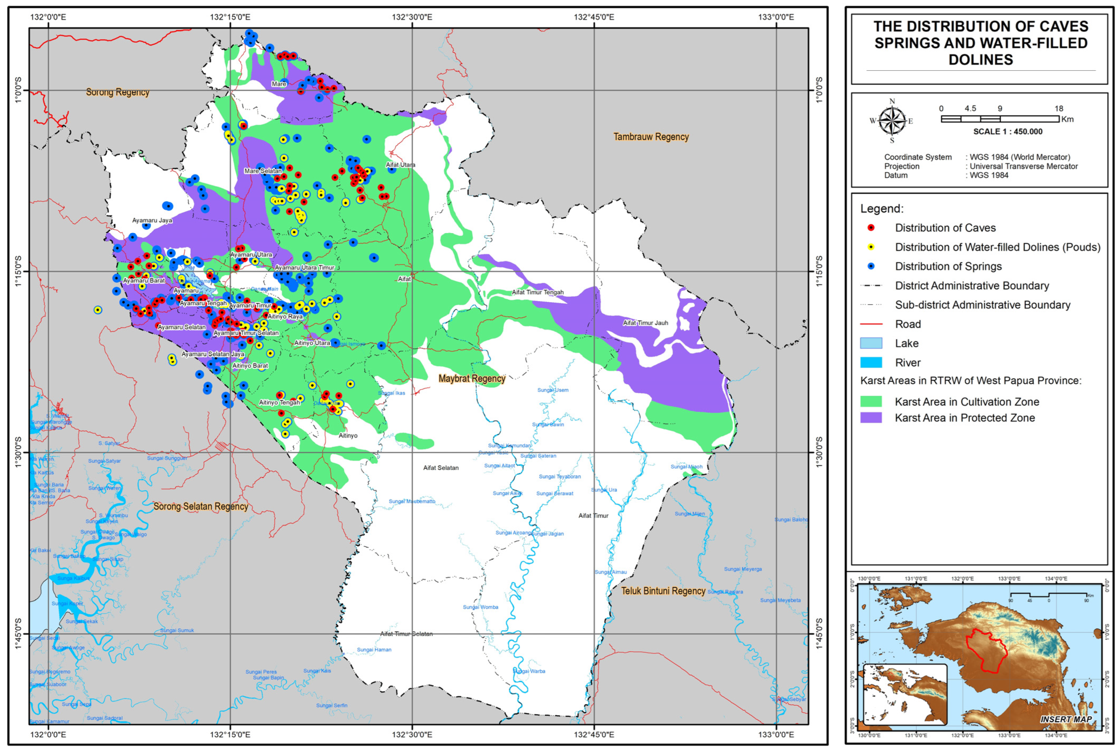
Figure 4. Research location showing the distribution of caves, springs, and water-filled dolines in the Maybrat Karst, highlighting the complexity of the karst system, habitat diversity, and the urgent need for protection. Data sources: Coordinate data derived from primary data by the authors; base maps from Indonesian Topographic Map (RBI) by BIG (2022) [24], Regional Spatial Plan (RTRW) of West Papua Province (2022) [25], and Geological Maps of Teminabuan and Mar Sheets (Geological Research and Development Centre, 1989) [26].
Sustainability 18 03287 g004
Figure 5. Closed Karst Depressions (Water-Filled Dolines) Supporting Freshwater Biodiversity and Endemism in the Maybrat Karst: (al) representative examples of water-filled dolines with closed hydrological systems, including drone images (a,f), field photographs (b,c,e,g), and satellite imagery (d,hl).
Sustainability 18 03287 g005
Figure 6. Seni and Wensi subterranean river systems showing springs, short surface flow segments, and ponors as indicators of closed karst drainage and habitats for endemic aquatic fauna.
Sustainability 18 03287 g006
Figure 7. Cherax cf. boesemani. Samples from the Yukase River (Total length: 203; 117; 118 mm).
Sustainability 18 03287 g007
Figure 8. Cherax cf. phing. Sample from the Seni River (Total length: 130; 170; 95 mm).
Sustainability 18 03287 g008
Figure 9. (a) Cherax cf. holthuisi from Lake Uter Aitinyo. (b) Cherax cf. holthuisi. (c) Cherax sp. Samples from the Wensi River (Total length: 112; 98; 139 mm).
Sustainability 18 03287 g009
Figure 10. Distribution of Endemic Aquatic Fauna Species by Watershed (DAS) in the Maybrat Karst and Hydrologically Connected Border Karst Areas. The colored areas represent watershed (drainage basin) units, indicating the spatial distribution patterns of endemic aquatic species.
Sustainability 18 03287 g010
Table 1. Criteria for Identifying Karst Elements.
Karst ElementIdentification Criteria
Karst HillsIdentified as prominent topographic relief with steep slopes (>25–30°) and high elevation differences over short distances, forming clustered hill patterns separated by closed depressions (dolines). In satellite imagery and DEM, they appear as rough and undulating terrain.
Dolines (Sinkholes)Small closed depressions with circular or oval shapes located between karst hills and having lower elevation than the surrounding terrain, typically with diameters of about 5 m–500 m. These depressions may contain soil, small ponds, springs, ponors, vegetation, or fine sediments.
UvalasLarge irregular depressions formed by the coalescence of several dolines, generally ranging from about 0.5–5 km in diameter with uneven relief. These areas may contain lakes, ponds, wetlands, savanna, shrubland, flat land, or a combination of dry and wet habitats.
PoljesVery large elongated karst depressions with relatively flat floors and clear boundaries with surrounding karst hills. Poljes are often filled with fine sediments, may experience seasonal flooding, extend for more than 5 km, and contain a combination of dry and wet habitats; they are often used for agriculture, settlements, or inland fisheries.
Permanent SpringsPoints where groundwater emerges at the base of karst hills or lithological contacts, appearing in imagery as the origin of small streams or areas of greener and wetter vegetation. Water typically flows from rock fractures or cave openings with relatively stable discharge throughout the year.
CavesCharacterized by cave entrances located on slopes or at the base of karst hills that can be accessed by humans and connected to underground chambers or passages formed by carbonate dissolution. These may occur as dry caves, river caves, spring caves, or vertical/ponor caves and often contain speleothems such as stalactites and stalagmites.
Subterranean RiversIdentified where surface streams disappear into ponors or karst depressions such as dolines or uvalas and re-emerge as springs. This process creates discontinuous surface drainage patterns indicating the presence of underground flow systems within the karst landscape.
Table 2. Indicators, Measurement Methods, and Scientific Basis for Assessing Aquatic Habitat Diversity in the Maybrat Karst Region.
IndicatorMeasurement MethodScore/Value
1. Aquatic habitat type diversityIdentification of karst aquatic habitats: subterranean rivers, water-filled dolines/ponds, karst lakes, karst swamps, water caves, springs and surface streams Score 1 per habitat type (0–7)
2. Habitat elevational variationClassification into 100–200, 200–350, and 350–500 m a.s.l.More elevation classes filled → higher diversity
3. Cherax, color/morphotype variationDocumentation of color/morphological variation across habitatsNumber of color/morphotype variants
Table 3. Karst Geodiversity and Its Hydrological–Ecological Functions Supporting Aquatic Habitats in Maybrat Regency.
Karst Geodiversity ElementQuantityMain Hydrological–Ecological Function
Proportion of Limestone/Karst Area to Total Regency Area±41.49%Indicates the dominance of carbonate rocks controlling karstification processes and groundwater recharge potential [1].
Karst Cone Hills±40–56 hills/km2Primary recharge zones channeling rainfall into karst aquifers and sustaining springs and aquatic habitats [1,10,23].
Water-Filled Dolines (Karst Ponds)±110Natural water reservoirs that create isolated habitats for endemic fauna [10,20,24].
Karst Springs (Total)±334Groundwater discharge points stabilizing river flow and freshwater habitat conditions [1,10].
  • River Springs
±142
  • Pond Springs
±156
  • Cave Springs
±36Link surface and subsurface systems and support stygofauna communities [6].
Major Karst Lakes (Ayamaru, Uter, Sidi)±3Closed-basin regulators of water storage and primary habitats [1,6].
Subterranean Rivers±178Maintain groundwater circulation and habitats for subterranean aquatic fauna [1,6].
Caves (Fossil and Active River Caves)±90Preserve paleoenvironmental archives and serve as conduits for underground flow supporting cave fauna [6,10]
Source: Primary data (results of a combination of participatory mapping and high-resolution satellite image interpretation).
Table 4. Aquatic Habitat Diversity of the Maybrat Karst and Its Endemism Potential.
IndicatorAssessment MethodFindings in the Maybrat KarstEndemism Potential
  • Diversity of aquatic habitat types
Identification of karst aquatic habitats based on global karst typology: subterranean rivers, water-filled dolines/ponds, karst lakes, karst swamps, water caves, springs and surface streams (score 0–7).Seven aquatic habitat types identified, including a major karst swamp area of ±4834.03 ha west of Lake Ayamaru.Very High, as greater habitat-type richness strongly correlates with higher endemism
2.
Elevational variation in aquatic habitats
Classification into three altitudinal bands: 100–200 m, 200–350 m, and 350–500 m a.s.l.All elevation classes are occupied, indicating a complete vertical gradient from lowland karst valleys to the Ayamaru Plateau.High, because full elevational gradients enhance environmental isolation and habitat differentiation [5].
3.
Color/morphotype variation in Cherax spp.
Documentation of Cherax spp. color and morphotype variants across five specific habitats: Lake Uter/Aitinyo, Yukase River, Wensi River, Seni River, and Sua Pond.17 color/morphotype variants recorded across five habitats, demonstrating strong microhabitat differentiation.Very high, as morphotype variation reflects ecological isolation, local adaptation, and potential speciation
Table 5. Color/Morphotype Variation in Cherax spp. Across Five Aquatic Habitats in the Maybrat Karst.
HabitatNumber
of Samples (n)
Color/Morphotype VariationsComparison with Described Endemic Species of Maybrat
Yukase River41. Reddish-brown body with blue claws and legs; 2. Olive-green body with bright blue claws; 3. Pale cream to yellow morph; 4. Shiny bluish-green morphGenerally similar to Cherax boesemani and C. gherardii, as Yukase River is located about 1.5 km from Lake Ayamaru, their original habitat, and flows into Lake Ayamaru.
Uter/Aitinyo Lake31. Dark brown to black body with blue claws; 2. Golden-yellow body with pale claws; 3. Reddish to purplish body with bright blue clawsSample 2 resembles C. holthuisi because it originates from the same habitat. The other samples may represent different or potentially new species, as Lake Uter is a hydrologically closed system.
Seni River31. Yellow-green body with bluish-green claws; 2. Bright blue body and claws; 3. Dark bluish-black morphSamples 1 and 2 resembles C. phing as they originate from the same habitat. Sample 3 may represent a different or potentially new species.
Sua Pond21. Brown to orange body with dark bluish claws; 2. Yellow-green to orange body with greenish-blue clawsLikely a different or new species due to the isolated and closed habitat, located at an elevation of 400–500 m asl.
Wensi River51. Dark purple to black body with blue claws; 2. Reddish-purple with bright blue legs; 3. Deep reddish-purple with blackish claws and blue legs; 4. Bright orange-red morph; 5. Reddish-purple with black claws and bright blue legsSample 4 resembles C. holthuisi, while the others may represent different or potentially new species.
Table 6. Endemic Aquatic Species of the Maybrat Karst Region: Taxonomy, Endemic Status, Native Habitat, and Watershed Distribution.
NoSpeciesEndemic StatusNative HabitatDistribution
1Cherax holthuisi [39]MaybratLake Uter/AitinyoLake Uter–Aitinyo
2Cherax boesemani [40]MaybratLake AyamaruLake Ayamaru; Kais Watershed
3Cherax gherardii [41]MaybratLake AyamaruLake Ayamaru; Kais Watershed
4Cherax phing [17]MaybratOmbak/Seni RiverKalabra Watershed
5Cherax snowden [16]Ayamaru Karst PlateauKlawak Creek Kalabra Watershed
6Melanotaenia boesemani [42]MaybratLakes Ayamaru & Uter/AitinyoKais Watershed
7Melanotaenia ayamaruensis [42]MaybratWensi River, Lake Uter and AyamaruKalabra, Kais Watershed
8Melanotaenia fasinensis [43]Ayamaru Karst PlateauFasin CreekKalabra Watershed
9Melanotaenia irianjaya [44] MaybratAouk tributaries (Suswa)Kalabra Watershed
10Melanotaenia ericrobertsi [45]MaybratSmall tributaries, SuswaKalabra Watershed
11Melanotaenia multiradiata [45]Ayamaru Karst PlateauMoswaren (South Sorong)Waromge Watershed
12Melanotaenia laticlavia [45]MaybratAifuf Creek Kamat Aifat Kamundan Watershed
13Melanotaenia klasioensis [46]Ayamaru Karst PlateauKlasio CreekKalabra Watershed
14Melanotaenia longispina [46]Ayamaru Karst Plateau Klahfot Kalabra Watershed
15Melanotaenia susii [46]Ayamaru Karst PlateauSusi CreekKalabra Watershed
16Pseudomugil reticulatus [44]MaybratLake AyamaruKais Watershed
17Glossogobius hoesei [47]MaybratLake AyamaruKais Watershed
18Zenarchopterus ornithocephala [48]Maybrat WatershedSenopi (Tambrauw)Kamundan Watershed
Disclaimer/Publisher’s Note: The statements, opinions and data contained in all publications are solely those of the individual author(s) and contributor(s) and not of MDPI and/or the editor(s). MDPI and/or the editor(s) disclaim responsibility for any injury to people or property resulting from any ideas, methods, instructions or products referred to in the content.