Article

Village Classification and Development Strategies Based on SOFM Neural Network: A Case Study of Hubei Province

1
School of Civil Engineering & Architecture, Wuhan Institute of Technology, Wuhan 430074, China
2
Village Culture and Human Settlements Research Center, Wuhan Institute of Technology, Wuhan 430074, China
*
Author to whom correspondence should be addressed.
Sustainability 2026, 18(5), 2489; https://doi.org/10.3390/su18052489
Submission received: 9 January 2026 / Revised: 17 February 2026 / Accepted: 27 February 2026 / Published: 4 March 2026
(This article belongs to the Section Sustainable Urban and Rural Development)

Abstract

China’s vast rural landscape exhibits pronounced regional disparities in both foundational resources and development potential. In the context of nationwide rural revitalization efforts, the emergent divergence in village development pathways underscores a pressing need for context-specific, classified interventions. To furnish a scientifically grounded typology of villages and inform differentiated development planning, this investigation focuses on Hubei Province as an illustrative case. Synthesizing survey data from 32,457 villages, we developed a multidimensional evaluation framework encompassing four pivotal domains: economic vitality, social service provision, ecological integrity, and cultural value. Leveraging the Self-Organizing Feature Map (SOFM) neural network—an unsupervised machine learning algorithm—we performed a cluster analysis on multi-source, heterogeneous datasets. This technique enabled the objective delineation of spatial typological patterns among Hubei’s villages, elucidated their underlying classification architecture shaped by multifaceted drivers, and demonstrated the methodological robustness and applicability of this approach for large-scale village categorization. Grounded in the derived typologies and informed by strategic directives from higher-tier planning instruments, we conducted a nuanced examination of the distinctive attributes characterizing each village type. The findings provide scientific evidence and decision-making support for village classification and rural revitalization planning in Hubei Province, with valuable implications for other regions with similar development foundations in China.

1. Introduction

Villages are the fundamental units of socio-economic activities in rural China [1], playing a vital role in safeguarding territorial ecological security and maintaining a harmonious human–land relationship [2]. However, under the rapid process of urbanization, rural areas are experiencing profound restructuring [1], and village development across the country is often challenged by problems such as homogenization and uncoordinated growth. In response, the rural revitalization strategy has received growing national attention, accompanied by a series of policies aimed at promoting rural transformation and sustainable development.
In June 2019, the Ministry of Natural Resources issued the Notice on Strengthening Village Planning to Promote Rural Revitalization, which called for the integration of spatial planning with village functional positioning and advocated for context-specific classification. Similarly, the 2022 Central Document No. 1 stressed the importance of accelerating the coordination between urban and rural village types and establishing scientifically defined categories for villages. Consequently, within the framework of rural revitalization, this study aims to construct a scientific village classification and evaluation framework, explore methodologies for precisely identifying village typologies, and formulate differentiated development strategies tailored to distinct village types. The objective is to provide scientifically robust and practically feasible references for village development planning and spatial layout.
Village classification is a fundamental component of regional studies [3]. By systematically identifying and analyzing the various factors influencing village development in a scientific and rational manner, we can assess the impact of these factors on rural development. This approach helps to understand the degree of spatial differentiation within rural areas and enables the categorization of villages. Such classifications provide a crucial basis for formulating targeted strategies and planning for village development [4]. Existing methods for village classification encompass both qualitative and quantitative approaches. Qualitative analysis includes methods such as inductive analysis [5,6], multi-factor comprehensive evaluation, and documentary analysis [7]. Research using these methods primarily focuses on justifying spatial layouts of villages from perspectives such as physical geography, socio-economics, government actions, and regional functions [8,9,10], thereby categorizing villages into types. For instance, Wang Mengjing et al. [11] developed a classification model based on “village health assessment—village potential evaluation—in-depth villager participation” to assess current village conditions. By integrating deep community engagement, they determined village classification outcomes. While qualitative analysis can propose context-specific classification methods aligned with current village development, it tends to be highly subjective. Furthermore, it lacks clearly defined criteria for measuring dimensions under different classification models, often overlooking the inherent complexity and dynamic nature within villages. Consequently, quantitative analysis has gradually become the predominant research method for village classification. It primarily includes spatial analysis [12], Ward’s spatial cluster analysis [13,14,15], analytic hierarchy process (AHP) [16], elastic coefficient modeling [17], kernel density analysis [18], and the entropy weight method [19], among others. For example, Shi Qiujie et al. [20] utilized sample data from 48 administrative villages across seven provinces in China. Employing cluster analysis, Kruskal–Wallis (KW) tests, and principal component analysis, they extracted eight orthogonal, practical, and easy-to-implement characteristic indicators to classify villages into six types. Chen Weiqiang et al. [21] evaluated rural development potential by analyzing spatial interactions between villages and surrounding geographic entities using POI (Point of Interest) data and a gravity model, thereby constructing a village classification model. Current quantitative research commonly employs a multi-factor evaluation system framework. This typically involves conducting quantitative analysis based on such a system to derive scores, then combining these scores with elements like expert opinion to finalize village classifications. However, despite the diversification of analytical techniques, classification results still exhibit significant uncertainty regarding objectivity and accuracy. This is due to varying regional delineation standards among scholars and low automation in the analytical process, making outcomes heavily reliant on an individual researcher’s interpretation of regional development dynamics.
With the progressive deepening of quantitative research methodologies by scholars, the emergence of machine learning approaches has brought transformative significance to village classification. By adopting a data-driven paradigm, it fundamentally reshapes the traditional subjective classification model reliant on manual expertise. This algorithmic, intelligent classification not only substantially enhances the efficiency and scale of classification tasks but also endows the results with objective, quantifiable, and reproducible scientific characteristics. It provides unprecedented decision-making support for optimizing resource allocation, formulating differentiated policies, and implementing precise interventions within rural revitalization efforts, ultimately propelling village governance toward a new stage of refinement and intelligence. Existing machine learning algorithms are broadly categorized into supervised and unsupervised learning. Scholars exploring this technical methodology have predominantly employed supervised learning approaches for village classification, including methods such as K-means [22,23] and Random Forest [24]. Notwithstanding considerable methodological advances in village classification research, prevailing techniques exhibit inherent limitations when tasked with the comprehensive analysis and clustering of high-dimensional, large-volume datasets characterized by the presence of anomalous observations. These approaches are architecturally predisposed to low-dimensional, spatially rudimentary classifications or experimental deployments involving modest sample sizes. At the sample level, extant scholarship predominantly concentrates on circumscribed samples or paradigmatic village cases, yielding a conspicuous lacuna in full-sample, province-wide empirical investigations of village typology. At the spatial level, a substantial portion of the literature remains tethered to descriptive renderings of classificatory outputs, with insufficient analytical penetration into the spatial autocorrelation structures and local clustering configurations embedded within these derived typologies. In response to these analytical imperatives, this study constructs a multidimensional composite indicator framework and, through the synergistic application of SOFM neural network clustering and spatial autocorrelation analysis, undertakes a systematic and objective classification of the complete village universe in Hubei Province. It endeavors to decode the spatial differentiation patterns and latent clustering architectures that organize this intricate rural landscape. Anchored in these empirically grounded typologies, the study proceeds to articulate a portfolio of differentiated development strategies—each precisely calibrated to the morphological and functional specificities of the identified village types.
The SOFM neural network exhibits a degree of robustness against outliers within the data. Its sufficient noise resistance makes it well-suited for processing complex, real-world measurement data. Furthermore, due to its unsupervised learning nature, the SOFM neural network can autonomously discover the intrinsic clustering structure within high-dimensional data while preserving the data’s topological structure and stability. By mapping each village’s high-dimensional feature vector—comprising multiple socio-economic and environmental indicators—onto a two-dimensional visual grid, the SOFM algorithm allows villages with similar attributes to self-organize into distinct clusters, forming an intuitive “village type map.” This process avoids the subjectivity of predefined classification criteria and reveals development patterns and regional distribution trends that traditional methods often overlook.
Hubei Province, with its remarkable geographical and economic diversity, acts as a “natural laboratory” for studying village typology in China. The western region is dominated by towering mountains and the Shennongjia Forest Area, the east is characterized by rolling hills, and the central part consists of the expansive Jianghan Plain. This spatial pattern—often summarized as “seven parts mountains, one part water, and two parts farmland”—has profoundly shaped the spatial distribution and evolution of village types. Economically, Hubei contains national central cities such as Wuhan and major urban agglomerations such as the Yichang–Jingzhou–Jingmen region, alongside extensive traditional agricultural zones and key ecological function areas. Owing to this diversity, nearly the full spectrum of village development stages found across China is represented within the province. Consequently, using Hubei as a case area not only enables more precise support for local rural revitalization planning but also yields methodological insights and demonstration value for other regions nationwide.
Building upon the preceding analytical framework, this study formulates two core research inquiries: (1) To what extent do villages in Hubei Province exhibit an objectively identifiable typological architecture when examined through a multidimensional lens of developmental indicators? (2) Do the village typologies generated via SOFM neural network clustering reveal statistically significant spatial heterogeneity, and can such spatially explicit patterns furnish a robust empirical foundation for the formulation of differentiated development strategies?

2. Study Area and Methods

2.1. Study Area

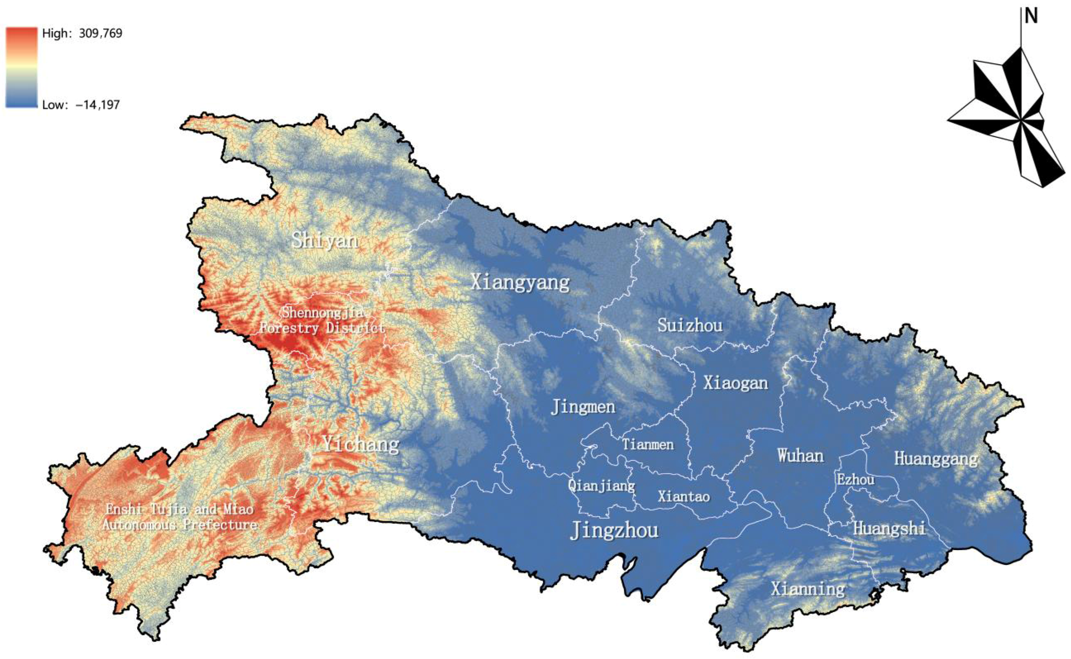
Hubei Province, located in central China along the middle reaches of the Yangtze River, features a diverse landform system of mountains, hills, plains, and water bodies. Positioned at the transition zone between the second and third steps of China’s topographic ladder, the province presents an incomplete basin structure, with high elevations on three sides and a lower central region (Figure 1). This distinctive natural configuration combines the development advantages of the eastern plains with the ecological resilience of the western mountains, enabling Hubei to function both as an ecological security barrier and a strategic resource reserve. Consequently, the province occupies an important position in China’s regional development strategy.
Administratively, Hubei consists of 13 prefecture-level divisions (12 cities and one autonomous prefecture) and 103 county-level units. Villages across the province exhibit pronounced variation in topography, land use, and socio-economic development, each reflecting distinct regional characteristics. Wuhan, the provincial capital, is a major hub for population aggregation and high-tech industries and serves as a core node for transportation and economic activity. The Yichang–Jingmen–Jingzhou metropolitan area is characterized by a concentration of manufacturing and processing industries, forming a prominent industrial belt. The Enshi Tujia and Miao Autonomous Prefecture hosts rich cultural resources—including Ba culture, Tusi heritage, revolutionary traditions, and Tujia and Miao cultures—as well as significant ecological assets such as the Wuling Mountain conservation area, constituting the ecological and cultural tourism zone of western Hubei. The province’s diverse regional features, deep cultural heritage, and varied resource endowments and development levels make it an ideal case for studying village classification and rural typologies [25].

2.2. Classification Methods

2.2.1. Village Classification Types and Defining Indicators

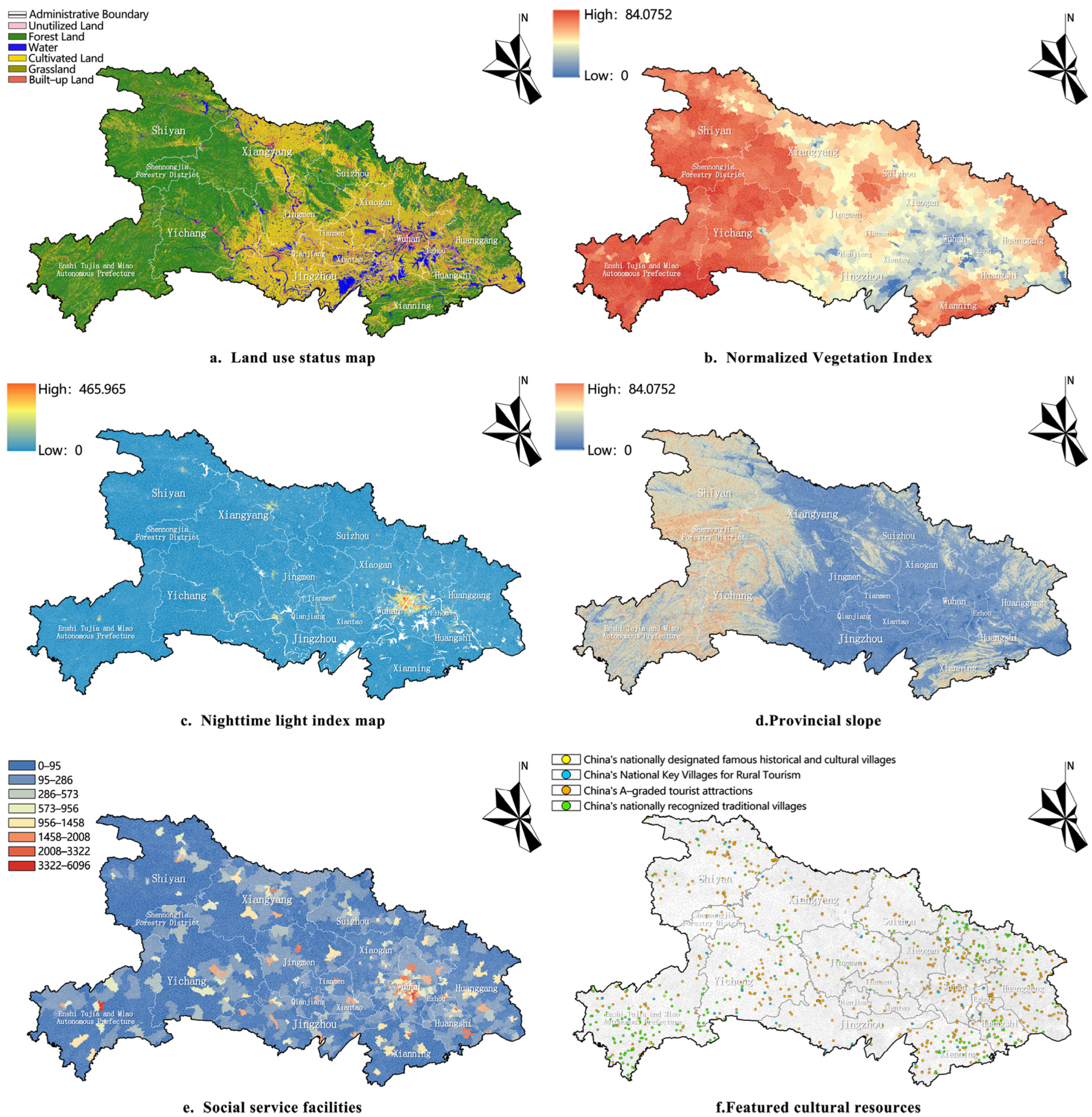
Quantitative village classification relies on constructing comprehensive indicator systems [26], grounded in a spatially integrated approach encompassing all aspects of territorial planning. Based on Hubei’s territorial spatial strategy and evolving urban–rural dynamics, primary indicators were developed through literature review and expert consultation, reflecting current conditions, future needs, and planned rural development. These include four key dimensions: economic development, social services, ecological environment, and cultural value. Additionally, 21 secondary factors were also incorporated, such as terrain slope, land use type, and normalized vegetation index (Figure 2). Various indicators exhibit significant spatial heterogeneity and imbalance (Table 1).
Economic Development Dimension: This dimension is operationalized through seven indicators, including construction land area and demographic statistics. These metrics collectively capture the intensity of regional economic dynamism, the sophistication of the industrial structure, and the capacity for factor concentration, serving as pivotal instruments for diagnosing the underlying drivers of rural development. Economic expansion acts as a primary force reshaping urban–rural spatial configurations, manifesting in land use transitions between agricultural and built-up areas. The presence of high-technology enterprises, for instance, signals economic agglomeration effects, while spatial analysis of nighttime light data provides empirical corroboration of economic disparities. Concurrently, population mobility facilitates labor redistribution, further propelling economic activity. These elements are intricately interwoven with developmental outcomes. Therefore, by quantifying economic scale, industrial morphology, and demographic fluxes, this indicator cluster furnishes a robust empirical foundation for discerning the endogenous momentum and exogenous limitations shaping village trajectories.
Social Service Dimension: This axis incorporates six factors, such as transportation networks and catering service availability. The spatial configuration of these amenities directly dictates settlement logic and fundamentally determines rural livability standards. Accessibility to public services constitutes a core organizing principle for rural settlement patterns, with the adequacy of such infrastructure profoundly influencing functional transitions within villages. By gauging the level of infrastructural provision, these social service indicators provide critical evidential support for optimizing spatial organization and advancing service equity between urban and rural spheres.
Ecological Environment Dimension: Four key factors are considered: Digital Elevation Model (DEM) data, slope gradient, Normalized Difference Vegetation Index (NDVI), and cultivated land distribution. These elements form the foundational natural constraint system for rural development, exerting a decisive influence on land use change dynamics across all categories. NDVI and cultivated land extent serve as proxies for land use ecological sensitivity, significantly conditioning the evolution of rural construction land. Consequently, this indicator set, by dissecting terrain carrying capacity, ecological resilience, and resource availability, establishes scientifically grounded parameters for mediating conflicts within the rural “production–living–ecological” spatial triad.
Cultural Value Dimension: This dimension is articulated through four indicators: locations of nationally designated Historic and Cultural Villages, nationally recognized Key Villages for Rural Tourism, national A-grade tourist attractions, and distribution points of Traditional Chinese Villages. These driving factors are pivotal for identifying and assessing a rural area’s cultural heritage, historical continuity value, and potential for tourism development. They play a decisive role in preserving cultural diversity, accentuating regional distinctiveness, and guiding development pathways that integrate cultural and tourism elements within village classification. Together, these indicators constitute a holistic assessment matrix for rural cultural capital. Their spatial distribution and concentration patterns critically inform the functional orientation and strategic developmental direction assigned to villages within the classification schema.

2.2.2. Village Classification System

This study employs the SOFM neural network model for analysis, a robust technique widely used in clustering and data mining [29]. As an unsupervised neural network method, SOFM demonstrates strong potential for achieving high analytical accuracy, occasionally outperforming supervised frameworks [30]. It facilitates data visualization, extracts low-dimensional features from high-dimensional data, and conducts category classification through competitive learning of input signals. SOFM has been extensively applied in clustering analyses within fields such as geography and ecology [31]. Unlike traditional clustering methods, SOFM does not require predefined category labels, thereby preserving the inherent spatial relationships and differentiation features of the samples. This makes it particularly suitable for large-sample studies, such as village classification. The main advantages of SOFM include (1) reducing the influence of subjective weight assignments; (2) effectively handling nonlinear data relationships; and (3) accommodating large and complex datasets, thus providing objective and sample-specific support for subsequent spatial planning.
The classification process involves the following steps:
This study utilizes a dataset comprising 32,457 identified villages in Hubei Province, along with 21 standardized indicator values for each village serving as input variables. These indicators are derived from diverse data sources and exhibit substantial variation in magnitude and units (e.g., GDP, normalized vegetation index, night-time light index, and the number of public service facilities). Directly inputting these unstandardized data could cause indicators with larger magnitudes to dominate the classification process, thereby obscuring the influence of other variables. To address this, the raw data are standardized using the Z-score method, as detailed in the formula below:
x std = x − μ δ
In this formula, the sample mean is denoted as μ, and the standard deviation as δ. This method transforms the indicators in the sample into a standard normal distribution with a mean of 0 and a standard deviation of 1, eliminating dimensionality issues while retaining the relative differences between indicators. This transformation ensures that the clustering analysis is not affected by the scale of the variables.
Next, the SOFM network was constructed using the newsom function in MATLAB R2024b, with specific parameters configured as follows:
(1)
Input Layer: Number of nodes = 21 (corresponding to the 21 indicators).
(2)
Competitive Layer: Initial neuron grid set to 5 × 5, with the optimal number of categories determined through progressive, iterative optimization.
(3)
Training Parameters: training iterations = 1000, initial learning rate = 0.1, with an exponential decay strategy applied as per the following formula:
η t = η 0 × e x p − t τ
where t represents the current iteration number, and τ denotes the decay constant.
(4)
Neighborhood Radius Decay: A Gaussian kernel was employed in the neighborhood function, with the initial radius set to half of the competitive layer dimensions (radius = 2.5). The radius was linearly reduced over iterations until it encompassed only the winning neuron (radius = 0).
(5)
Convergence Criteria: Convergence was determined based on the update magnitude of weights in the competitive layer and topological stability. The model was considered converged when the average rate of weight change over 100 consecutive iterations fell below a threshold (∆W < 10−4) and the topological order, characterized by the ordering entropy of competitive layer neurons, stabilized.
Through the self-organizing learning process, classification results were mapped onto the competitive layer. Due to the unsupervised nature of the SOFM network, the number of categories may influence the clustering outcomes [26]. In this experiment, the optimal number of village categories in Hubei Province was determined to be five, reflecting distinct patterns in the multidimensional indicator data.
Regarding dimensionality reduction, this study deliberately refrained from applying Principal Component Analysis (PCA) to optimize the input data, primarily due to the following considerations:
(1)
Requirement for Information Integrity: Village classification necessitates a comprehensive representation of multidimensional features encompassing economic, social, ecological, and cultural aspects. Although PCA can reduce dimensionality and mitigate multicollinearity, it may obscure the practical interpretation of certain original indicators (e.g., compressing cultural value indicators into secondary principal components), thereby diminishing the interpretability and applicability of classification results for planning purposes.
(2)
Model Adaptability: The SOFM neural network inherently handles high-dimensional nonlinear data. The predefined 5 × 5 competitive layer network was capable of processing the 21-dimensional input data, rendering additional dimensionality reduction unnecessary.
Finally, the standardized 21-dimensional indicators were input into the SOFM neural network. Prior to training, only mean imputation was performed on the data to ensure full coverage of all villages across the province, ultimately yielding a comprehensive and context-specific village classification scheme.

2.2.3. Spatial Autocorrelation Analysis

Spatial autocorrelation analysis is primarily employed to evaluate whether observations of the same variable at adjacent locations exhibit a significant correlation. It encompasses two categories: global spatial autocorrelation and local spatial autocorrelation. Within the context of village classification, the former is used to measure the overall spatial autocorrelation of village types across the entire study area, while the latter serves to identify spatial clustering and outliers in local regions. Commonly used spatial autocorrelation indices include Moran’s I index, the Geary C index, and the Getis–Ord General G, among others. In this study, Moran’s I index is applied to conduct global spatial autocorrelation analysis of the village classification results, while clustering and outlier analysis are utilized for local spatial autocorrelation analysis.
The specific formula for Moran’s I index is as follows [32]:
M o r a n ’ s   I   = n ∑ i = 1 n ∑ j = 1 n W ij x i − x - x j − x - ∑ i = 1 n ∑ j = 1 n W ij ∑ i = 1 n x i − x - 2
In this formula, I denotes the global Moran’s I index, with xi and xj representing the attribute values at locations i and j, respectively. x refers to the attribute value of the observed variable, while x - is the mean value of the observed variable’s attributes. n represents the number of units, and the matrix element ω i j captures the topological relationship between spatial elements. The value of Moran’s I ranges from −1 to 1, with its sign and magnitude reflecting the degree of spatial clustering and correlation between variables. A positive value indicates a positive correlation between the observed variable values, which manifests as either high–high or low–low clustering, suggesting similarity in category. Conversely, a negative value reflects a negative correlation, with high–low clustering, indicating dissimilar categories. Furthermore, the larger the absolute value of the correlation (whether positive or negative), the stronger the clustering; values approaching zero, however, suggest a lower degree of spatial correlation.
The significance test of Moran’s I index generally involves two coefficients: the Z value and the p value. If both coefficients fall within an acceptable range, the test suggests a statistically significant clustering or dispersion pattern between the variables. Specifically, when the Z value is less than −1.65 or greater than +1.65, and the p value is less than 0.1, the confidence level is 90%. If the Z value is less than −1.96 or greater than +1.96, and the p value is less than 0.05, the confidence level is 95%. If the Z value is less than −2.58 or greater than +2.58, and the p value is less than 0.01, the confidence level is 99%.
To further investigate the local correlations within different categories of villages, clustering and outlier analysis techniques are employed to assess the local Moran’s I index. The spatial weight relationships between each village and its neighboring counterparts are calculated. By applying the Anselin Local Moran’s I statistic, statistically significant hot spots, cold spots, and spatial outliers are identified, thereby assessing the correlation between village types in various categories and their neighboring village types. The formula for this calculation is as follows:
I i = x i − X - S i 2 ∑ j = 1 , j ≠ i n ω i , j x j − X -
S i 2 = ∑ j = 1 , j ≠ i n x j − X - 2 n − 1
In this calculation, Xi represents the attribute value of feature i, X - denotes the average value of the corresponding attribute, ω i , j represents the spatial weight between features i and j, and n refers to the total number of features [33].
The hotspot analysis map generated from this calculation allows for the identification of four distinct types of regions. The high–high cluster area indicates that a particular type of village is surrounded by similar villages, forming a spatial concentration. The low–low cluster area represents an aggregation of villages that do not belong to the target type, indicating a concentration of dissimilar village types. The high–low anomaly area reveals that a certain type of village is surrounded by villages of different types, highlighting spatial irregularities. Lastly, the low–high anomaly area shows that a non-target village is surrounded by a significant number of target villages, demonstrating an inverse spatial pattern.

3. Village Classification Outcomes

Using the SOFM neural network model in conjunction with a two-way verification mechanism, a total of 32,457 villages across Hubei Province were classified into five distinct types. Synthesizing the framework of the four village classifications outlined in the Comprehensive Rural Revitalization Plan (2024–2027) and conducting an in-depth analysis of the existing spatial configuration of villages throughout Hubei Province, this research grounds its typology in the deep interplay among topographic gradients, locational advantages, and functional mandates. In close consultation with the Hubei Provincial Rural Revitalization Strategic Plan and incorporating structured expert input, we propose a five-fold village classification system: “Urban Service-Oriented villages”, “Industrial Agglomeration villages”, “Ecological Conservation villages”, “Cultural Heritage villages”, and “Basic Improvement villages” (Table 2).
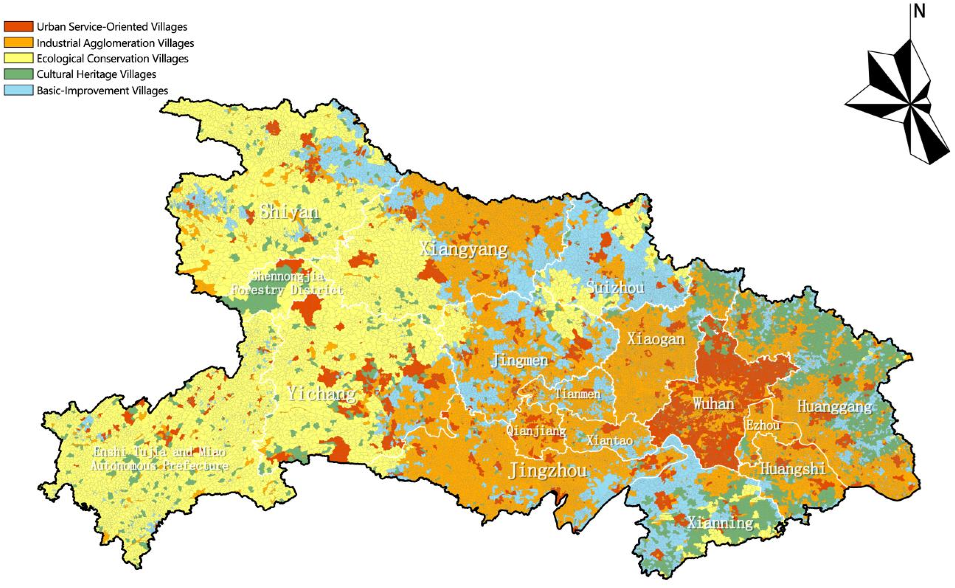
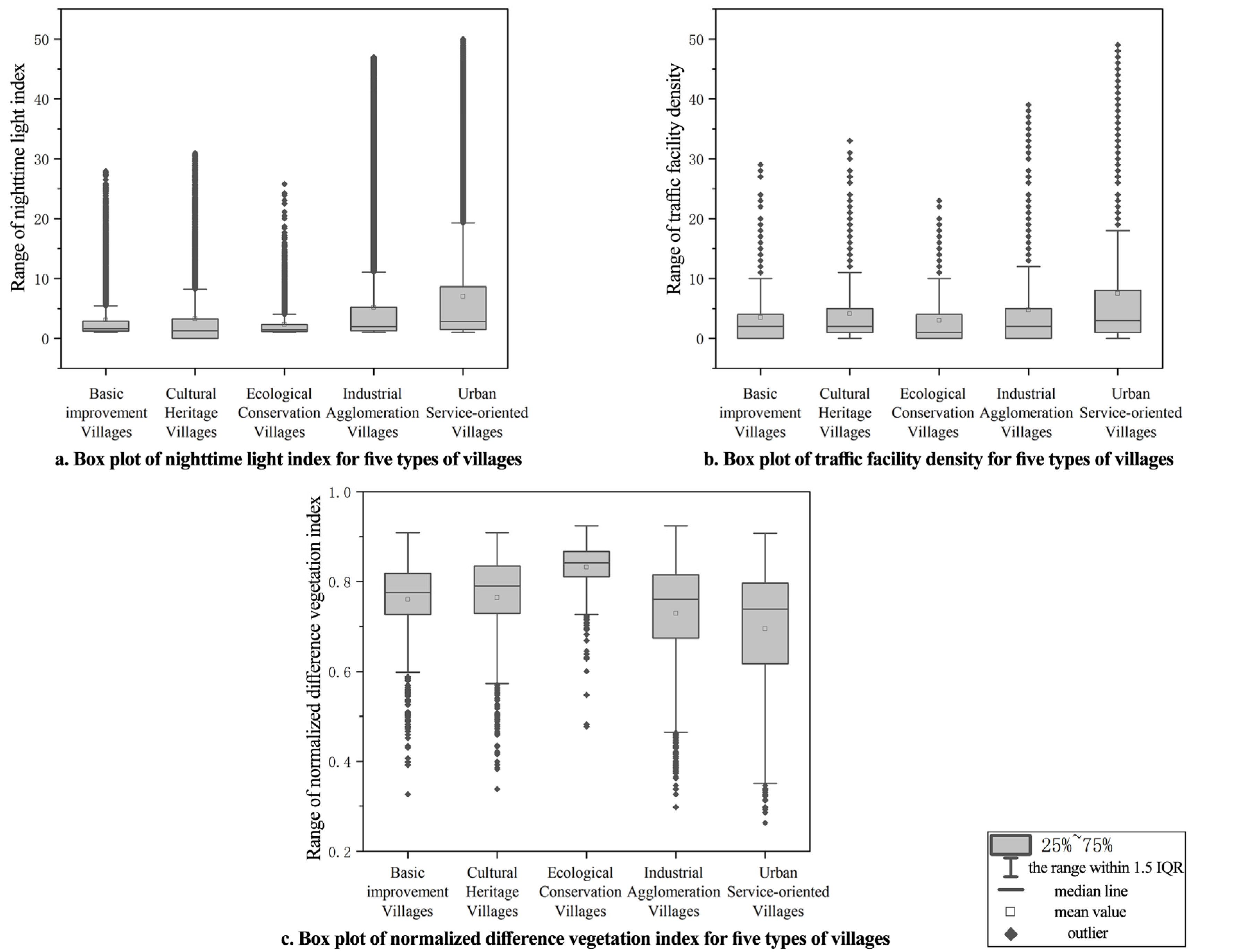
Using the SOFM neural network model in conjunction with a two-way verification mechanism, a total of 32,457 villages across Hubei Province were classified into five distinct types. This classification reveals a spatially diverse village structure characterized by “industrial agglomeration in the plains, ecological barriers in the mountains, suburban service expansion, and cultural node integration” (Figure 3). Furthermore, different village types exhibit significant systematic differences in key characteristic indicators (Figure 4). Regarding the ecological environment, Ecological Conservation villages demonstrate the most prominent performance in the Normalized Difference Vegetation Index (NDVI), with a median value of 0.82 and a concentrated distribution. This reflects their superior ecological baseline and high vegetation coverage. In contrast, Urban Service-Oriented and Industrial Agglomeration villages exhibit relatively lower NDVI medians (0.68 and 0.72, respectively), correlating with their higher proportion of construction land and relatively constrained agricultural or ecological space. At the level of social services, Urban Service-Oriented and Industrial Agglomeration villages record the highest median traffic facility density (4.2 and 3.8, respectively). The average for Urban Service-Oriented villages reaches 7.1, indicating overall superior locational conditions and a well-developed road network. Conversely, Ecological Conservation villages have the lowest traffic density, consistent with their spatial characteristics of being situated in mountainous terrain with significant topographic constraints. In terms of economic development, the Night-Time Light index visually illustrates the gradient differences in economic activity and population agglomeration. The average NTL for Urban Service-Oriented villages is notably high at 8.81, significantly surpassing other types. Industrial Agglomeration villages rank next, followed by Cultural Heritage and Basic Improvement villages at medium-to-low levels, with Ecological Conservation villages at the lowest. This further corroborates the distinct orientations of different village types concerning their functional positioning and development intensity. (The detailed average values of 21 indicators for different types of villages are shown in Appendix A Table A1 at the end of the article.).
Overall, the multidimensional indicators for each village type are mutually reinforcing, collectively forming the numerical foundation for the SOFM model classification. They clearly delineate a functional spectrum, ranging from highly urbanized and industrially agglomerated types to those prioritizing ecological conservation and cultural preservation.
Based on the classification results (Table 3), a total of 4400 urban service-oriented villages were identified in Hubei Province, accounting for 14% of the total. These villages are mainly concentrated in the Wuhan metropolitan area, followed by Yichang City, with scattered distributions across other urban centers. These villages are predominantly located in plain regions, forming a hierarchical development structure of “core–sub-core–county level”, primarily concentrated in Wuhan and adjacent cities, exhibiting a strong clustering tendency. Their functional structure follows a tiered spatial pattern: the inner tier consists mainly of villages within Wuhan, which support the city’s technology and service industries; the middle tier includes villages in Yichang, Xiangyang, and Xiaogan, where inter-city industrial linkages connect agricultural production with urban consumption; and the outer tier comprises characteristic towns that leverage transportation hubs and regional advantages to promote differentiated industrial development.
There are 14,094 industrial agglomeration-type villages, representing 43% of the total—the largest proportion among all types. These villages are primarily distributed around central Wuhan and its surrounding areas, including Jingzhou, Huanggang, and Xiaogan. They exhibit a “linear + clustered” spatial pattern along the Yangtze River Economic Belt and major transportation corridors, reflecting strong regional concentration, focusing on high-tech industries, logistics, transportation, and primary industrial activities. Spatially, three development models can be identified: (1) Manufacturing Clusters—villages concentrated in the Jianghan Plain and suburban zones, where development relies on agricultural resource processing; in cities such as Jingzhou and Yichang, vertical industrial chains integrate raw material supply, processing, and logistics; (2) Commercial and Logistics Corridors—villages distributed along the Yangtze River Economic Belt and high-speed rail lines, particularly around Wuhan, which benefits from its strategic position as the “Thoroughfare of Nine Provinces”; and (3) Specialized Agricultural Zones—villages in the eastern hilly and western mountainous regions, such as Tunbao and Shengjiaba in Enshi Prefecture, that adopt a “one village, one product” model to develop distinctive agricultural clusters.
A total of 6846 ecological conservation-type villages were identified, accounting for 21% of the total. These villages are mainly located in Shiyan City, the Enshi Tujia and Miao Autonomous Prefecture, and the Shennongjia Forestry District. Ecological conservation-type villages occupy karst and mountainous areas aligned with ecological control zones and demonstrate settlement patterns adapted to rugged terrain, underscoring the strategic ecological role of western Hubei as an environmental security barrier along the middle reaches of the Yangtze River. As a critical water conservation area for the Yangtze River basin, these villages typically maintain forest coverage exceeding 65% and provide approximately 70% of the water for the middle route of the South-to-North Water Diversion Project. From the perspective of ecological protection and spatial planning, this category also includes villages within the Shennongjia Forestry District, which serve as habitats for endangered species such as the golden snub-nosed monkey.
There are 2596 cultural heritage-type villages, representing 8% of the total. These villages are concentrated along the Tujia and Miao cultural belt in southwestern Hubei, the revolutionary heritage area in the northeast, and the Shennongjia Forestry District, closely associated with the province’s distinctive cultural landscapes. Heritage-type villages possess high concentrations of cultural and tourism resources, with 93% located within national 3A-level or higher scenic areas, forming integrated cultural–ecological–tourism landscapes. Their distribution includes clusters centered on revolutionary heritage sites in northeastern Hubei and the Dabie Mountains, anti-Japanese war relics, and traditional settlements and intangible cultural heritage communities of ethnic minorities in the Wuling Mountains.
Finally, 4521 basic improvement-type villages were identified, accounting for 14% of the total. These villages are primarily distributed in intercity border zones or remote areas distant from major urban centers, such as the borders of Huanggang, Jingmen, and Suizhou. These regions generally feature lower transportation accessibility and moderate economic activity levels, and approximately 68% of these villages are situated in hilly or gently sloping terrain. Due to their distance from major expressway entrances, their average night-time light index is only one-fifth that of villages within the Wuhan metropolitan influence zone, reflecting challenges such as limited transportation accessibility and moderate economic vitality.

4. Analysis of Spatial Aggregation and Distribution Characteristics of the Five Village Types

4.1. Global Spatial Aggregation Distribution Characteristics of the Five Village Types

To reveal the structural characteristics of the spatial distribution of the five types of villages in Hubei Province, a global spatial autocorrelation analysis was conducted. Village type codes were used as spatial variables, and the global Moran’s I index was calculated, as shown in Table 4.
The results presented in the table indicate that the global Moran’s I index for the classification of the five village types in Hubei Province is 0.46, which is significantly greater than 0. This suggests that villages of similar types tend to spatially cluster, exhibiting either high–high or low–low concentration patterns. The Z-score of 29.29 is well above the critical value (2.58) at the 99% confidence level, and the p-value is less than 0.01, confirming statistical significance at the 99% level. These findings demonstrate a significant positive spatial autocorrelation among the village types in Hubei Province, indicating that villages of the same or similar types are not randomly distributed but instead form distinct spatial clusters.
This result provides a quantitative validation, from a global perspective, of the diversified village system pattern described in Section 3—namely, “industrial clusters on the plains, ecological barriers in the mountains, extended services in suburban areas, and cultural nodes interwoven throughout.” For instance, industrial cluster villages are densely distributed in continuous patches across the Jianghan Plain, while ecological conservation villages exhibit large-scale aggregation in the western Hubei mountains. These patterns not only reflect the spatial coordination and agglomeration effects driven by functional objectives but also underscore the profound influence of natural geography and socio-economic factors on the functional differentiation of villages.

4.2. Local Spatial Aggregation Distribution Characteristics of the Five Village Types

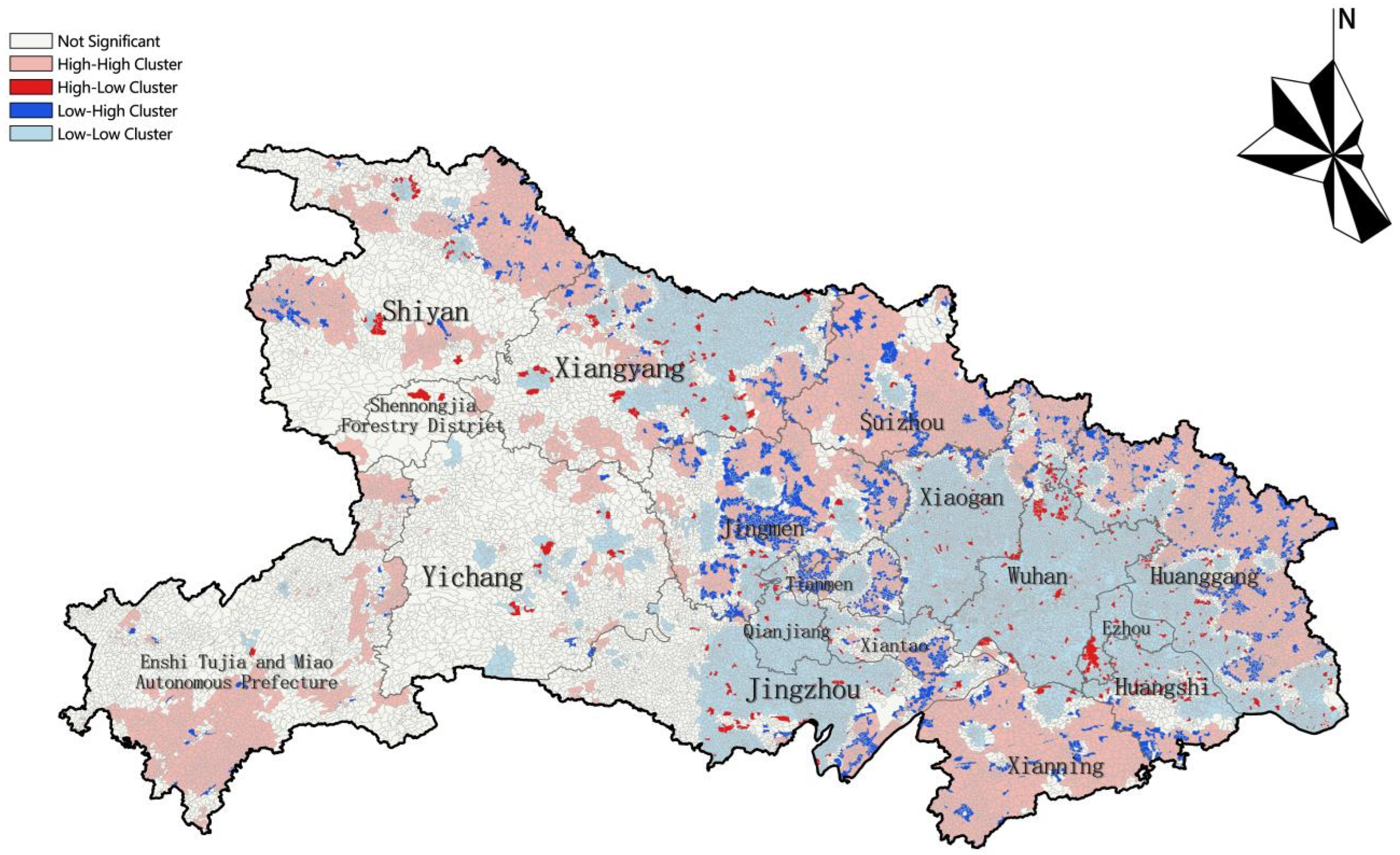
Through the analysis of the local Moran’s I index, five types of villages were further identified in terms of their spatial aggregation and anomalies (Figure 5). The results highlight significant spatial patterns of aggregation and differentiation across the different village types, as detailed below:
The low–low aggregation areas are primarily located in Wuhan, Xiangyang, Qianjiang, Jingzhou, Xiaogan, Huangshi, and Huanggang. In these regions, Wuhan is dominated by urban service-type villages, which are typically situated in suburban areas and serve as extensions of urban functions. However, due to urban expansion and shifts in land use, the development of these villages is somewhat constrained, giving rise to a low–low aggregation pattern. In Xiangyang and other cities, industrial cluster-type villages are more prevalent. While these villages possess a certain industrial base, their growth has been relatively sluggish due to geographic location, resource availability, and market conditions, resulting in limited economic vitality and a low–low aggregation effect. This pattern underscores the strong spatial interdependence between urban service functions and industrial core areas while also highlighting the mixed characteristics of villages in plain regions, where industrial functions predominate.
High–high concentration areas are predominantly located in Shiyan City, Enshi Tujia and Miao Autonomous Prefecture, Xianning City, Huanggang City, and Suizhou City. Within this region, Shiyan and Suizhou feature a predominance of infrastructure-enhancement-type villages. This is closely related to their geographical positioning at the transition zone between the Qinba Mountains and the plains, where the complex terrain, relatively poor transportation infrastructure, and constrained development conditions have shaped the spatial distribution of village types, leading to a high degree of consistency in terms of developmental characteristics. In contrast, Enshi Tujia and Miao Autonomous Prefecture is primarily characterized by eco-conservation-type villages, which leverage the area’s rich natural resources and ecological advantages. This aligns with the strategic positioning of the western Hubei Wuling Mountain area as a national key ecological function zone. The distribution of these villages is strictly constrained by ecological protection boundaries and karst topography, which results in a distinct high–high concentration pattern. Meanwhile, Huanggang and Xianning Cities are primarily home to cultural heritage-type villages, rich in historical and cultural resources, with distinct folk traditions. These villages exhibit a strong correlation with the red cultural belt in northeastern Hubei and the ancient village cultural area in southern Hubei, highlighting the influence of historical and cultural heritage in shaping the spatial clustering of village types.
High–low anomaly areas are primarily scattered along the periphery of metropolitan regions and at the junctions of ecological functional zones. They manifest as isolated industrial or urban-service-oriented villages surrounded by ecological conservation or basic enhancement-type villages, forming localized development “highlands.” These anomalous zones reflect the spatial heterogeneity characteristic of urban–rural transition belts or eco-economic interlaced areas. For instance, in areas such as northern Huangpi District and southern Hong’an County on the periphery of the Wuhan metropolitan circle, certain villages classified as cultural heritage or ecological conservation types possess distinctive and high-value resource endowments. Their attributes significantly differ from the surrounding larger context dominated by industrial agglomeration and basic enhancement, resulting in isolated “island” areas enveloped by lower-value surroundings. This anomaly pattern indicates that even within plains regions where economic functions are predominant, unique cultural and ecological resources can still preserve localized village development trajectories at a micro-scale.
Conversely, in locations such as the northern Huangpi District of Wuhan City, Zigui County of Yichang City, and Baokang County of Xiangyang City, sporadically distributed industrial agglomeration-type villages emerge as “highlands” within their regions. These are encircled by extensive surrounding areas of ecological conservation-type villages, forming high–low anomaly points. These specific anomaly point areas likely exhibit weaker economic radiation capacity and overall lagging regional development. It is therefore advisable to subsequently strengthen industrial development within these “highland” villages, fostering more mature industrial systems that can drive the formation of industrial clusters in neighboring villages.
Low–high (L-H) anomaly clusters are primarily distributed in regions such as Jingmen City, Huanggang City, Tianmen City, Suizhou City, the Enshi Tujia and Miao Autonomous Prefecture, and Xianning City. These are frequently observed among villages categorized as Cultural Heritage Conservation types and Ecological Conservation types, such as those within the ethnic cultural heritage belt of southwestern Hubei and the Red Culture area of northeastern Hubei. In these zones, individual villages with weak developmental foundations are often surrounded by highly concentrated clusters of cultural heritage or ecological conservation villages. This pattern reflects localized development imbalances within areas rich in cultural resources.
Similarly, in the vicinity of high–high agglomeration areas of ecological conservation villages—such as in Yunxi County, Shiyan City, and Lichuan City, Enshi Prefecture—a small number of villages classified as needing foundational enhancement may exist. Within high–high agglomeration areas of cultural heritage conservation villages in Huanggang City, individual villages may also appear as “foundation-enhancement” types due to factors like lower resource significance or lagging conservation and development efforts, forming L-H anomaly points.
These villages are typically situated in transition zones between ecological reserves and human activity areas, or on the peripheries of core cultural heritage zones. Factors such as more rugged terrain or poorer infrastructure contribute to their “need for enhancement” status, creating a stark contrast with the widespread “high ecological quality” attributes of their surroundings. They effectively become “developmental depressions” within high-value functional areas.
The existence of these L-H anomaly points reveals the issue of internal development imbalance even within culturally or ecologically affluent regions. Cultural heritage conservation villages often possess significant cultural tourism potential. However, the lack of supporting cultural tourism facilities and services in surrounding areas hinders the formation of a complete cultural tourism industry chain, marking these as key areas for focused attention in future rural revitalization efforts. Conversely, ecological conservation villages face the direct contradiction between ecological protection and local livelihood development. They represent critical nodes for implementing ecological compensation mechanisms and exploring pathways to realize the value of ecological products.
Overall, the local spatial autocorrelation analysis unveils the intricate and orderly spatial differentiation patterns of the five village types in Hubei Province from a micro-scale perspective. It not only confirms the village system pattern of “industrial agglomeration in the plains, ecological barriers in the mountains, service extension in suburban areas, and cultural nodes embedded” but also uncovers the internal complex structure of village type distribution within the province. The core plains manifest a “low–low” agglomeration profile, anchored by industrial functions yet blended with diverse ancillary types, where urban service roles are intricately woven into the fabric without coalescing into standalone clusters. In stark contrast, the outlying mountainous and cultural districts exhibit “high–high” agglomeration marked by functional coherence and sharp delineation, governed predominantly by ecological preservation, foundational upgrading, and cultural continuity. Anomalous zones underscore the pivotal role of localized resource assets (H-L zones) and expose internal developmental asymmetries within regions (L-H zones). These deviant configurations suggest that spatial stratification among village types arises not solely from inherent natural assets and locational advantages but is also critically molded by an array of dynamic factors, including the vigor of policy instruments, efficacy of regional cooperative mechanisms, and the reach of infrastructure networks. Illustratively, “H-L” industrial outliers signal an imperative to foster regional supply-chain synergy and communalize public services, while “L-H” ecological hinterland settlements necessitate more resilient environmental stewardship and diversified economic alternatives.
This refined spatial identification profoundly reflects the ultimate manifestation of village functional differentiation under the combined influence of natural geographical foundations, historical–cultural legacies, and socio-economic development policies. It provides an important spatial decision-making basis for implementing differentiated and precise village development strategies through zoning and classification within the provincial region.

5. Recommendations for Rural Planning and Management

5.1. Urban Service-Oriented Villages: The Frontier of Urban–Rural Integration

As a cornerstone of urban–rural integration in Hubei Province, urban service-oriented villages are primarily concentrated in the Wuhan metropolitan area and are driven by non-agricultural industries. From a spatial perspective, prominent hotspot clusters are primarily concentrated in the core region of the Wuhan Metropolitan Circle and around the central urban areas of cities such as Yichang and Xiangyang (H-H zones). Villages in these clusters are characterized by intensive non-agricultural industrial activities and a high degree of population and economic agglomeration. In contrast, isolated or coldspot villages are sporadically distributed in suburban belts of other prefecture-level cities (L-L zones), exhibiting limited service functionality and a constrained capacity to absorb urban economic radiation. For hotspot clusters (H-H zones), strategic focus should be directed toward reinforcing their role as “regional service cores,” driving vertical extension of industrial chains, and upgrading service sectors. For example, hotspot villages within the Wuhan Metropolitan Circle could specialize in high-value functions such as technology services, modern logistics, and health and wellness tourism, aiming to develop regional hubs for agricultural product processing and integrated cold-chain logistics to achieve cross-village facility synergies and service integration. For isolated or coldspot villages (L-L zones or non-clustered areas), planning should pivot toward functional complementarity and network integration. These villages should be encouraged to cultivate niche, small-scale, and high-quality urban agriculture initiatives. Strengthening transportation linkages and industrial collaboration with proximate hotspot areas, along with selectively absorbing spillover functions, can help avert marginalization resulting from repetitive, low-value development patterns.
Certain Metropolitan Service-Oriented villages, though geographically remote, exhibit notable economic vitality (H-L zones). These villages often rely on proximity to specific industrial parks or transportation hubs, forming relatively self-sustained economic microcosms. In such contexts, despite their peripheral locations, the radiating influence of industrial zones drives local economic activity. Subsequent development strategies should prioritize enhancing industrial park infrastructure and leveraging transportation hub effects to sustain growth momentum. Future development should prioritize resource aggregation and industrial upgrading, with an emphasis on headquarters economies, technological innovation, and modern service industries. Public service facilities should be improved to urban standards, enabling these villages to function as strategic nodes for promoting high-quality urban–rural integration.

5.2. Industrial Agglomeration Villages: Core Economic Engines in Plain and Hilly Areas

Industrial agglomeration villages are pivotal economic units within the rural spatial framework of Hubei Province. Their defining feature is the high concentration of specialized industries across villages, along with the deep integration of industrial chains. This category of villages exhibits contiguous hotspot clusters in the Jianghan Plain and along major transportation corridors, characterized by integrated industrial chains and strong economic interdependence. Development should be oriented toward “cluster-based, chain-integrated” approaches, promoting cross-administrative industrial cluster planning. In contrast, in localized areas of eastern and western Hubei, industrial cluster-oriented villages are more dispersed, with smaller industrial scales and weaker linkages. Here, emphasis should be placed on “one village, one specialty; deep cultivation of distinctive industries,” avoiding blind pursuit of scale expansion.
Through spatial analysis, we have identified several L-H areas, where the central villages exhibit high industrial agglomeration and economic prosperity, while surrounding villages remain economically underdeveloped. These central villages typically possess relatively complete industrial chains and strong radiating capacity. However, due to the lagging development of neighboring villages, regional development remains uneven and insufficient, failing to fully harness the benefits of industrial agglomeration. To address this, planning should strengthen synergistic development between central and surrounding villages, leveraging industrial transfer, technology diffusion, and other mechanisms to foster shared growth across the area. These villages should adopt a “1 + N” industrial cluster model, which organizes the space into three primary zones: production, residential, and ecological. This structure not only facilitates the smooth operation of industrial chains but also meets the essential needs of the local population. An illustrative example is the rural cluster construction plan for Qianchang Township in Jingxian County, which includes villages like Jiantiao, Yanli, Wuling, Liuling, Zawu, and Shengou. This plan utilizes the “1 + 5” industrial cluster model, promoting an eco-efficient farming system based on rice, turtles, soft-shelled turtles, fish, shrimp, and frogs in rotation, creating a demonstration area for the “One High, Three New” ecological farming and breeding model. Additionally, it drives the development of specialized agriculture and fosters collaboration between the primary and tertiary industries, ensuring rapid and sustainable income growth for villagers. The plan also encompasses the renovation of rural housing, infrastructure development, and the enhancement of environmental features such as landscape design, aiming to improve both the living conditions and economic well-being of villagers. This “1 + 5” new rural demonstration zone also actively promotes rural tourism, significantly enhancing the quality of life and production conditions.
However, the development of these villages may face challenges, such as ecological pressures and the risk of industry homogenization. To mitigate these issues, it is crucial to adopt green technologies and create distinctive brands, further solidifying these villages’ roles as engines for economic growth in the Yangtze River Economic Belt.

5.3. Ecological Conservation Villages: Mountainous Ecological Barriers and Resilience Units

In terms of spatial distribution, these villages strictly adhere to natural constraints and the principles of sustainable development. In the mountainous regions of western Hubei (Enshi, Shiyan, and Shennongjia), they form large-scale, contiguous hotspot zones with critical and sensitive ecological functions. Such areas must prioritize ecological conservation and enforce strict controls, rigorously implementing ecological protection redlines and territorial spatial use regulations. Planning should promote a dual-drive strategy of “ecological compensation + distinctive industries.” For example, in Enshi’s hotspot zones, efforts could focus on developing understory economies and ecotourism while exploring horizontal ecological compensation mechanisms and carbon sink trading systems to transform ecological value into economic benefits. For villages sporadically distributed in other mountainous areas, ecological functions are relatively isolated, and they face constrained development prospects. Such regions may, while ensuring ecological security, appropriately develop small-scale, high-value ecological products and nature education initiatives—such as high-altitude medicinal herbs or ecological tea plantations—while strengthening their integration with surrounding cultural and tourism nodes through route connections, forming an “ecological micro-network.”
Certain ecological conservation zones contain H-L areas, where village economies are relatively prosperous, but the surrounding environment is ecologically fragile. The development of these villages often relies on green industries such as ecotourism, yet they simultaneously face tensions between ecological protection and economic growth.
In terms of industrial development, ecological conservation villages should cultivate specialized, high-value industries based on local resource advantages. For example, in the Qinba Mountains, there is potential to develop high-altitude cool-climate vegetables and medicinal herbs, whereas in the Wuling Mountains, forest farming, organic tea cultivation, and related industries can be expanded. A multifunctional development system that integrates “ecological compensation, cultural preservation, and specialized industries” should be promoted, leveraging ecotourism and health tourism to overcome regional development constraints.

5.4. Cultural Heritage Villages: Spatial Anchors of Cultural Identity and Continuity

Cultural heritage villages constitute a key component of Hubei Province’s rural classification system, carrying the responsibility of preserving and transmitting regional cultural traditions. Villages of this type demonstrate pronounced spatial clustering within the Ethnic Cultural Heritage Belt of southwestern Hubei and the Red Culture Zone of northeastern Hubei, where cultural assets are abundant, and tourism infrastructure is comparatively developed. Conversely, traditionally dispersed villages elsewhere face the risk of becoming isolated “preservation enclaves.” For hotspot cultural clusters, a strategic approach should involve fostering the holistic conservation and revitalization of “cultural–ecological precincts.” This entails integrating cultural resources across multiple villages, curating thematic routes such as cultural immersion tours and intangible heritage experiential programs, and establishing regional cultural brand alliances. For instance, clustered villages in Enshi Tujia and Miao Autonomous Prefecture could collaboratively pursue designation as the “Wuling Mountain Area Tujia Cultural–Ecological Conservation Zone.” For scattered cultural villages, planning should adopt a model of “precision conservation and thematic activation,” eschewing large-scale redevelopment. Encouraging private-sector involvement in restorative adaptive reuse—such as developing boutique lodgings and artisan workshops—while utilizing digital platforms to amplify their visibility and connectivity is advised.
Spatial analysis further identifies L-H zones within this category, where cultural heritage-oriented villages are situated adjacent to areas with relatively scarce cultural resources. While these heritage-rich villages often possess considerable cultural tourism appeal, the lack of supporting tourism facilities and services in neighboring villages impedes the development of an integrated cultural tourism value chain. To mitigate this, planning should prioritize regional cultural tourism synergy, addressing infrastructure and service gaps collaboratively to co-brand cultural tourism offerings and strengthen the region’s overall cultural tourism competitiveness.

5.5. Basic Improvement Villages: Revitalization Hubs for County-Level Coordination

Basic improvement villages are generally located at considerable distances from central cities, limiting their ability to directly absorb industries from core economic zones. Instead, they primarily function as key nodes facilitating the flow of resources between counties. In Hubei Province’s rural typology, these villages are classified as transitional, serving as spatial hubs that connect urban and rural areas and coordinate inter-county development. To mitigate these challenges, upgrading key transport routes and enhancing cold-chain logistics systems are essential to reduce circulation losses. Similarly, in Jiangzhai Village, Songhe Township, Jingmen City, the village leverages the Xuguang Expressway to establish a cross-county logistics distribution center. By integrating agricultural resources from both Jingmen and Suizhou cities and developing a regional supply chain network, this initiative promotes coordinated development of production and transportation while improving the efficiency of rural economic activities. For example, in Sanlifan Township, Luotian County, Huanggang City, most villages are located in hilly and mountainous terrain influenced by the Dabie Mountains, resulting in high costs for agricultural product transport. To mitigate these challenges, upgrading key transport routes and enhancing cold-chain logistics systems are essential to reduce circulation losses. Similarly, in Jiangzhai Village, Songhe Township, Jingmen City, the village leverages the Xuguang Expressway to establish a cross-county logistics distribution center. By integrating agricultural resources from both Jingmen and Suizhou cities and developing a regional supply chain network, this initiative promotes coordinated development of production and transportation while improving the efficiency of rural economic activities.

5.6. Village Development Guidelines

Based on the village classification, management recommendations, and the specific resources and development characteristics of each village type, this study proposes tailored development guidelines for the five village categories (Table 5). These guidelines are designed to enhance the precision, scientific rigor, and practical feasibility of future planning and development initiatives.

6. Discussion

This study introduces a methodologically innovative paradigm for village classification, operationalized through a sequential framework: “construction of a multidimensional indicator system–clustering via Self-Organizing Feature Map (SOFM) neural networks–validation through spatial autocorrelation–formulation of differentiated strategies.” By incorporating SOFM neural networks—an unsupervised machine learning technique—the proposed approach markedly enhances the objectivity and analytical precision of full-sample village typology at scale. It thus offers a data-driven, reproducible methodology for provincial-level village classification within the institutional context of territorial spatial planning.
In contrast to conventional quantitative approaches—such as entropy weighting, analytic hierarchy process (AHP), and K-means clustering—traditional methods frequently depend on dimensionality reduction or subjectively assigned weights to accommodate high-dimensional, nonlinear, and heterogeneous data. These techniques also encounter substantial computational bottlenecks and are prone to the loss of topological structure when applied to extremely large datasets. The present study circumvents these limitations by deploying an SOFM neural network to project the 21-dimensional feature vectors of all 32,457 villages in Hubei Province directly onto a two-dimensional topological lattice. This operation retains the full semantic richness of critical indicators—including cultural heritage and ecological status—while enabling adaptive, topology-preserving clustering of complex territorial systems. As a result, the classification achieves superior global coherence and local interpretability.
This study presents several substantive advances relative to extant machine learning-based village classification research:
(1)
Full-sample coverage with high-dimensional feature integration: Prevailing studies often rely on sampled subsets or restricted administrative units, rendering them susceptible to sampling bias and incapable of capturing spatially continuous typological patterns at the provincial level. By synthesizing 21 indicators across four dimensions for the complete set of 32,457 villages in Hubei Province, this study accomplishes the first genuinely full-sample, high-dimensional clustering analysis in this field at the provincial echelon. This design ensures both the statistical representativeness and the comprehensive spatial coverage of the resulting classification.
(2)
Unsupervised clustering via machine learning without subjective weighting: Existing classifications are frequently derived either from region-specific heuristics, yielding typologies misaligned with the regulatory imperatives of territorial spatial planning, or from expert-driven scoring systems, which embed inherent subjectivity. This study pioneers an integrated analytical pathway that fuses “higher-level main functional zone planning–unsupervised SOFM clustering–spatial autocorrelation cross-validation.” This configuration preserves the epistemic autonomy of data-driven classification while reinforcing policy coherence through alignment with top-down spatial governance frameworks, thereby enhancing both the implementability and policy responsiveness of the results.
(3)
Spatially explicit diagnosis tightly coupled with precision policymaking. Much of the current literature concludes with the mere assignment of categorical labels, neglecting intra-typological spatial heterogeneity. This study extends the analytical trajectory beyond classification per se by embedding both global and local spatial autocorrelation analyses, thereby precisely delineating hotspots (high–high clusters), cold spots (low–low clusters), and spatial anomalies (high–low and low–high outliers) within each village type. By advancing from “typology identification” to “spatial pattern interrogation,” this framework not only illuminates macro-level geographic regularities—such as the dichotomy between plains as industrial agglomerations and mountains as ecological buffers—but also exposes microscale complexities, including “cultural enclaves marked by economic underperformance” and “development pockets embedded within ecologically protected zones.” These spatially anchored insights furnish actionable planning intelligence capable of remedying the entrenched “one-size-fits-all” logic that has long constrained differentiated village policy.
In summation, through the confluence of full-sample analytics, high-dimensional topology-preserving clustering, and spatially explicit diagnostic capacity, this study systematically addresses three enduring deficiencies in the village classification literature: pronounced subjectivity, the analytical incompatibility between large sample sizes and high-dimensional data structures, and the tenuous linkage between classification outputs and spatial characteristics. By advancing a methodology anchored in SOFM neural network clustering and spatial autocorrelation, this research establishes a scientifically rigorous and operationally transferable methodological archetype for fine-grained village classification, differentiated policy orchestration, and the targeted deployment of rural revitalization resources—scalable from provincial to national jurisdictions.

7. Conclusions and Prospects

7.1. Conclusions

By establishing a comprehensive evaluation index system and applying the SOFM neural network model for quantitative analysis, in conjunction with Hubei’s actual development conditions, a scientifically robust and operationally feasible provincial village classification system has been developed. Building on this framework, tailored development guidelines are proposed for each village type, providing a foundation for evidence-based planning and implementation. The main conclusions of the study are as follows:
(1)
The SOFM neural network enables objective, quantifiable, and reproducible village classification, supporting refined and evidence-based rural governance.
(2)
Villages in Hubei Province are classified into five types: urban service (4400, 14%), mainly in Wuhan; industrial agglomeration (14,094, 43%), concentrated in cities such as Yichang, Xiangyang, and Xiaogan; ecological conservation (6846, 21%), mainly in Shiyan and Shennongjia; cultural heritage (2596, 8%), primarily in Enshi Prefecture and Shennongjia; and basic improvement (4521, 14%), mainly in border areas of Huanggang, Jingmen, and Suizhou.
(3)
Differentiated development strategies are recommended: urban service villages should focus on headquarters economies, technology, and services; industrial agglomeration villages on “1 + N” industrial clusters; ecological conservation villages on protection and high-value local industries; cultural heritage villages on cultural preservation and industry; and basic improvement villages on improving transportation and logistics. Furthermore, considering the spatial agglomeration characteristics of each village type, the planning focus for hotspot cluster areas should emphasize strengthening regional linkages, upgrading industrial functions, and mitigating agglomeration risks. In contrast, for scattered or coldspot areas, the emphasis should shift towards functional supplementation, cultivating distinctive features, enhancing network connectivity, and ensuring foundational safeguards.

7.2. Limitations and Future Research

While this study establishes a scientific village classification system and proposes development guidelines, it is not without certain limitations. Regarding research data, the study primarily relies on publicly available data sources, such as the Third National Land Survey and the Seventh National Population Census. Although these sources are authoritative and comprehensive, they suffer from issues such as insufficient update frequency or limited precision. Specifically, the lack of direct and real-time monitoring methods for micro-level data within villages (e.g., detailed land use changes) may affect the accuracy and timeliness of classification results. In terms of research methodology, while the SOFM neural network model effectively handles high-dimensional and nonlinear relationships within samples, its classification performance for the complex and dynamically evolving village systems requires further validation. Additionally, given the distinct natural, cultural, and socio-economic characteristics across different regions—each with unique village development patterns—this model may not be directly applicable to other areas with pronounced regional disparities.
Therefore, future research will focus on the following improvements: ① collecting representative village classification samples that account for the integrated geographic characteristics of different regions, thereby enhancing the model’s generalizability across diverse areas; ② combining qualitative research methods with quantitative analysis to delve deeper into the socio-economic mechanisms, cultural drivers, and behavioral logic underlying village classification. This approach will more fully integrate rural revitalization strategies with regional development patterns, capturing internal heterogeneity and dynamic changes within villages, and providing more refined and personalized decision-making support for rural revitalization.
In summary, this study not only provides a scientific basis for village classification and planning in Hubei Province’s rural revitalization efforts but also offers methodological insights and practical models for similar research in other regions. By following the research pathway of “data-driven analysis, typology-guided planning, and policy-oriented integration,” it contributes to advancing village governance toward greater precision and intelligence.

Author Contributions

Y.N.: funding acquisition, writing—review and editing. Q.L.: methodology, investigation, formal analysis, conceptualization, writing—original draft. Y.L.: supervision, methodology, writing—review and editing. All authors have read and agreed to the published version of the manuscript.

Funding

This work was financially supported by the Innovative Fund Project of the Humanities and Social Sciences Platform at Wuhan Institute of Technology (grant number 2025RWSKPTCXJJ18).

Institutional Review Board Statement

Not applicable.

Informed Consent Statement

Not applicable.

Data Availability Statement

The data presented in this study are available on request from the corresponding author.

Conflicts of Interest

The authors declare no conflicts of interest.

Appendix A

Table A1. The average values of all 21 indicators across five types of villages.
Indicators
Villages
Urban Service-OrientedIndustrial AgglomerationEcological ConservationCultural HeritageBasic Improvement
Economic DevelopmentConstruction Land6.275.612.745.185.41
Population Data1280.50585.3012.8048.20210.75
GDP11,850.254850.6018.40145.30820.75
Nighttime Light Index8.815.012.583.893.66
Number of High-Tech Enterprises0.090.080.010.040.03
Number of Listed Companies0.050.030.000.010.01
Number of Industrial Parks0.020.030.000.000.01
Social Service IndicatorsTraffic Facility Quantity7.104.953.544.883.98
Catering Service Facility Quantity40.9812.846.8918.9918.73
Recreational and Entertainment Facility Quantity 4.132.260.393.741.67
Science, Education, and Cultural Facility Quantity 9.467.031.096.264.24
Medical and Health Care Service Facility Quantity 14.3713.571.9311.187.17
Public Service Facility Quantity2.611.890.451.541.32
Ecological EnvironmentTopographic Elevation32.5078.601180.50625.30185.00
Topographic Slope2.154.6030.2020.459.30
Normalized Difference Vegetation Index0.690.730.830.760.76
Cultivated Land8.974.8622.2017.6212.31
Cultural ValueChina’s National Historical and Cultural Villages0.000.000.000.010.00
National Key Villages for Rural Tourism in China0.000.000.000.020.00
National A-Grade Tourist Attractions0.040.010.010.070.01
Spatial Distribution of Traditional Chinese Villages0.000.000.000.090.00

References

  1. Li, Y.; Fan, P.; Liu, Y. What makes better village development in traditional agricultural areas of China? Evidence from long-term observation of typical villages. Habitat Int. 2019, 83, 111–124. [Google Scholar] [CrossRef] [Scilit]
  2. Yu, K.; Li, D.; Han, X.L.; Luan, B. Landscape Security Pattern Approaches to New Rural Planning and Urban Expansion: A Case Study of Magang Village. Urban Plan. Forum 2006, 5, 38–45. (In Chinese) [Google Scholar]
  3. Hedlund, M. Mapping the Socioeconomic Landscape of Rural Sweden: Towards a Typology of Rural Areas. Reg. Stud. 2016, 50, 460–474. [Google Scholar] [CrossRef] [Scilit]
  4. Wu, Y.N. Research on Village Classification and Development Strategies Based on Development Potential Assessment. Master’s Thesis, Harbin Institute of Technology, Harbin, China, 2022. (In Chinese) [Google Scholar]
  5. Kim, Y.-T.; Choi, S.; Kim, H.-G.; Im, S.-B. Development of Evaluation Indicators System by Rural Village Types. J. Korean Soc. Rural Plan. 2014, 20, 37–49. [Google Scholar] [CrossRef] [Scilit]
  6. Tang, W.; Malanson, G.P.; Entwisle, B. Simulated village locations in Thailand: A multi-scale model including a neural network approach. Landsc. Ecol. 2009, 24, 557–575. [Google Scholar] [CrossRef] [Scilit]
  7. Blunden, J.R.; Pryce, W.T.R.; Dreyer, P. The Classification of Rural Areas in the European Context: An Exploration of a Typology Using Neural Network Applications. Reg. Stud. 1998, 32, 149–160. [Google Scholar] [CrossRef] [Scilit]
  8. Aizawa, H.; Hayashi, H.; Hozuni, H. A Study on Village Classifications Analysis from the Regional Resources in Rural Area. J. RURAL Plan. Assoc. 1995, 13, 7–18. [Google Scholar] [CrossRef] [Scilit]
  9. Kojiya, H.; Kato, Y. Rural villages classification based on ecological values and intentions of farmers. J. RURAL Plan. Assoc. 2004, 23, 55–60. [Google Scholar]
  10. Gajić, A.; Krunić, N.; Protić, B. Classification of Rural Areas in Serbia: Framework and Implications for Spatial Planning. Sustainability 2021, 13, 1596. [Google Scholar] [CrossRef] [Scilit]
  11. Wang, M.J.; Lv, Y.F.; Wu, C.F.; Qiu, Y.K. Research on the classification model of county villages under the background of territorial spatial planning: A case study of Laizhou City, Shandong Province. Urban Dev. Stud. 2020, 27, 1–7. (In Chinese) [Google Scholar]
  12. Shan, Y.B.; Ma, X.D.; Qiu, F.D. Distribution Patterns Characteristics and Type Classification of the Rural Settlements in Central Jiangsu Province. Sci. Geogr. Sin. 2012, 32, 1340–1347. (In Chinese) [Google Scholar]
  13. Yang, X.H.; Wu, X.L.; Fan, Y.; Han, X.; Zhang, S.; Jin, X. Village classification and renovation strategy under planning guidance in Lijin County. J. Agric. Mach. 2020, 51, 232–241. (In Chinese) [Google Scholar]
  14. Zhang, G.H.; Ye, Z.Q. Research on the Development Dilemmas and Implementation Paths of Different Types of Villages from the Perspective of Rural Revitalization. Rural Econ. 2019, 37, 17–25. (In Chinese) [Google Scholar]
  15. Tang, L.N.; Liu, Y.; Pan, Y.C.; Ren, Y. Evaluation and Zoning of Rural Regional Functions in Pinggu District, Beijing Based on BP Model and Ward Method. Geogr. Sci. 2016, 36, 1514–1521. (In Chinese) [Google Scholar]
  16. Xiao, T.Q.; Sun, H.X.; Li, X.X.; Zhang, H.; Li, Y. Research on Evaluation and Classification Strategies for Village Development Potential: A Case Study of the Weifan Area on the South Bank of Chaohu Lake. J. Huaiyin Inst. Technol. 2023, 32, 69–77. (In Chinese) [Google Scholar]
  17. Liu, J.L.; Liu, Y.S.; Li, Y.R.; Hu, Y. Spatio-temporal coupling relationship between rural residential land use and rural population in China from 2007 to 2015. J. Nat. Resour. 2018, 33, 3–13. (In Chinese) [Google Scholar]
  18. Zhu, Z.; Yang, H.; Hu, Y.M.; Chen, Y.; Ke, C. Evaluation of village development potential and village classification by multi-source data. J. Agric. Resour. Environ. 2021, 38, 1142–1151. (In Chinese) [Google Scholar]
  19. Zhang, X.R.; He, Y.; Dong, J.Y. Research on Landscape Pattern Based on Evaluation of Village Development Potential. J. Nanjing For. Univ. (Nat. Sci. Ed.) 2024, 48, 155–164. (In Chinese) [Google Scholar]
  20. Shi, Q.J.; Liu, T.; Cao, G.Z. Research on the Indicator System for Village Classification Oriented to Planning and Construction. Hum. Geogr. 2017, 32, 121–128. (In Chinese) [Google Scholar]
  21. Chen, W.Q.; Dai, Y.Q.; Geng, Y.W.; Gao, H.; Ma, Y.H. Research on Village Classification Method Based on POI Data and Gravity Model. J. Agric. Mach. 2020, 51, 195–204. (In Chinese) [Google Scholar]
  22. Li, M.Q. Research on Village Classification and Development Strategy Based on SOM-K-Means Algorithm. Master’s Thesis, Anhui Jianzhu University, Hefei, China, 2024. (In Chinese) [Google Scholar]
  23. Zhang, R. Research on Village Classification and Development Path of Baiquan County Based on Hollowing and Development Potential Evaluation. Master’s Thesis, Northeast Agricultural University, Harbin, China, 2024. (In Chinese) [Google Scholar]
  24. Pan, Y.P.; Zhao, X.; Wang, J.; Zhang, Y.Q.; Liu, Y.L. Research on the Identification Method of Village Development Types Based on SMOTE-RF Algorithm. J. Geo-Inf. Sci. 2023, 25, 163–176. (In Chinese) [Google Scholar]
  25. Pan, Y.; Zhao, X.; Zhang, Y.; Luo, H. A large-scale village classification model for tailored rural revitalization: A case study of Hubei province, China. J. Geogr. Sci. 2024, 34, 2364–2392. [Google Scholar] [CrossRef] [Scilit]
  26. Xie, F.F.; Luo, F.H.; Liu, Z.; Fang, C.Y. Village Classification: Technical Methods and Planning Guidelines from the Perspective of Territorial Space Planning—A Case Study of Nanning City. J. Hum. Settl. West China 2024, 39, 139–144. (In Chinese) [Google Scholar]
  27. Kummu, M.; Kosonen, M.; Masoumzadeh Sayyar, S. Downscaled gridded global dataset for gross domestic product (GDP) per capita PPP over 1990–2022. Sci. Data 2025, 12, 178. [Google Scholar] [CrossRef] [Scilit]
  28. Wu, Y.Z.; Shi, K.F.; Chen, Z.Q.; Liu, S.; Chang, Z. An Improved Time-Series DMSP-OLS-Like Data (1992–2023) in China by Integrating DMSP-OLS and SNPP-VIIRS. 2021. Available online: https://dataverse.harvard.edu/dataset.xhtml?persistentId=doi:10.7910/DVN/GIYGJU (accessed on 8 January 2026).
  29. Chen, C.-Y.; Chiang, J.-S.; Chen, K.-Y.; Liu, T.-K.; Wong, C.-C. An Approach for Fuzzy Modeling based on Self-Organizing Feature Maps Neural Network. Appl. Math. Inf. Sci. 2014, 8, 34. [Google Scholar] [CrossRef] [Scilit]
  30. Gupta, R.; Nanda, S.J. Cloud detection in satellite images with classical and deep neural network approach: A review. Multimed. Tools Appl. 2022, 81, 31847–31880. [Google Scholar] [CrossRef] [Scilit]
  31. Liao, G.; He, P.; Gao, X.; Lin, Z.; Fang, C.; Zhou, W.; Xu, C.; Deng, L. Identifying Critical Area of Ecosystem Service Supply and Demand at Different Scales Based on Spatial Heterogeneity Assessment and SOFM Neural Network. Front. Environ. Sci. 2021, 9, 714874. [Google Scholar] [CrossRef] [Scilit]
  32. Zhang, C.-y.; Zhao, L.; Zhang, H.; Chen, M.-n.; Fang, R.-y.; Yao, Y.; Zhang, Q.-p.; Wang, Q. Spatial-temporal characteristics of carbon emissions from land use change in Yellow River Delta region, China. Ecol. Indic. 2022, 136, 108623. [Google Scholar] [CrossRef] [Scilit]
  33. Zangeneh, A.; Najafi, F.; Khosravi, A.; Ziapour, A.; Molavi, H.; Moradi, Z.; Bakhshi, S.; Shadmani, F.K.; Karamimatin, B.; Soofi, M. Epidemiological patterns and spatiotemporal analysis of cardiovascular disease mortality in Iran: Development of public health strategies and policies. Curr. Probl. Cardiol. 2024, 49, 102675. [Google Scholar] [CrossRef] [Scilit] [PubMed]
  34. Lian, Y. Strengthening the Protection of Traditional Villages in the Context of Rural Revitalization. Beijing Obs. 2019, 3, 30. (In Chinese) [Google Scholar]
Figure 1. Elevation map of Hubei Province.
Sustainability 18 02489 g001
Figure 2. Current situation map of some indicators in Hubei Province.
Sustainability 18 02489 g002
Figure 3. The pattern of villages in Hubei Province.
Sustainability 18 02489 g003
Figure 4. Boxplot of selected indicators for five types of villages.
Sustainability 18 02489 g004
Figure 5. Hotspot analysis of the five village types.
Sustainability 18 02489 g005
Table 1. Table of Village Classification Indicators.
Criterion LayerIndicator LayerYear of DataRationale for Indicator SelectionData Source (Indicator Description)
Economic Development IndicatorsConstruction Land2023Regional Economic VitalityThe findings of the Third National Land Survey
Population Data2023Population BaseThe Seventh National Population Census
GDP2022Regional Economic VitalityScientific Data [27]
Nighttime Light Index2023Regional Economic Vitalitythe improved DMSP-OLS-like data [28]
Number of High-Tech Enterprises2023Industrial Guidance and Factor Agglomeration CapacityEnterprise information inquiry platform (AiQiCha)
Number of Listed Companies2023
Number of Industrial Parks2023
Social Service IndicatorsTraffic Facility Quantity2023Rural LivabilityOpenStreetMap (OSM) Point of Interest (POI) data
Catering Service Facility Quantity
Recreational and Entertainment Facility Quantity
Science, Education, and Cultural Facility Quantity
Medical and Health Care Service Facility Quantity
Public Service Facility Quantity
Ecological Environment IndicatorsTopographic Elevation2023Natural Foundational ConditionsGeospatial Data Cloud
Topographic SlopeNASA Earth Science Data Platform
Normalized Difference Vegetation IndexNASA: MOD13A3 Dataset
Cultivated LandThe findings of the Third National Land Survey
Cultural Value IndicatorsChina’s National Historical and Cultural Villages2023Distinctive ResourcesNational Integrated Online Government Service Platform
National Key Villages for Rural Tourism in ChinaThe official website of the Ministry of Culture and Tourism
National A-Grade Tourist AttractionsHubei Provincial Department of Culture and Tourism
Spatial Distribution of Traditional Chinese VillagesThe Sixth Batch of the Traditional Chinese Villages List Released by the Ministry of Housing and Urban–Rural Development
Data Specification: The data employed in this study encompass all administrative villages within Hubei Province, totaling 32,457 villages and covering every county (city, district) across the province. This constitutes a full-sample analysis rather than a sampling-based study. Consequently, the research findings possess complete representativeness at the provincial scale, free from biases that may arise from sampling randomness.
Table 2. Classification criteria for villages.
Village TypeDefinition
Urban Service-OrientedDriven primarily by non-agricultural industries, the employment structure has made a marked shift toward high-value sectors. The integration of multiple industries is increasingly evident, with stronger population agglomeration effects, and the spatial layout reveals a pattern of concentric expansion.
Industrial AgglomerationLeveraging resource endowments and locational advantages, a spatial organization model has been established, where the primary industry serves as the core sector, with related industries developing synergistically. Public service facilities are relatively well-developed.
Ecological ConservationPrimarily situated in ecological conservation areas, with the core function of safeguarding the ecological security barrier, its spatial layout rigorously adheres to natural constraints and the principles of sustainable development.
Cultural HeritageVillages rich in natural and historical-cultural resources—such as heritage villages, traditional villages, ethnic minority villages, and those renowned for distinctive scenic tourism [34]—are predominantly concentrated in culturally vibrant areas. These villages are endowed with profound historical and cultural assets, with their cultural resources encompassing both tangible and intangible aspects.
Basic improvementSpatially, it serves as a pivotal hub connecting urban and rural areas while coordinating inter-county relations. Its core features include the iterative upgrading of infrastructure, the dual-driven development of industrial structure, and the cross-regional sharing of public services.
Table 3. The distribution quantity and characteristics of 5 types of villages in Hubei Province.
CityUrban Service-Oriented VillagesIndustrial Agglomeration VillagesEcological Conservation VillagesCultural Heritage VillagesBasic Improvement Villages
Shiyan City142225116683440
Xianning City9514377296399
Xiaogan City1642582-218155
Yichang City3897461319167190
Enshi Tujia and Miao Autonomous Prefecture1751283333187205
Wuhan City2052483-104-
Directly governed county-level administrative region18713714441452
Jingzhou City21528427644373
Jingmen City18381315445634
Xiangyang City233156250057342
Ezhou City45275-138
Suizhou City10311215026605
Huanggang City3322266261185668
Huangshi City85546113050
Total440014,094684625964521
Proportion14%43%21%8%14%
FeatureEmphasize the service functions of urban fringe areas.Concentration along the Han River Economic Belt.Reflecting mountainous agriculture and ecological protection characteristicsClosely linked to the distribution of historical and cultural resources.Displaying transitional urban–rural features.
Table 4. Global Moran’s I Index Table for Five Types of Villages.
Analysis CriteriaMoran’s I IndexZ-ScoreP-Score
Village Classification Outcomes0.4629.290.000
Table 5. Development guidelines for five types of villages in Hubei province.
Village TypeIndustrial DevelopmentPublic Space Enhancement and RehabilitationSpatial Control and Management
Urban Service-Oriented VillagesFocus on the strategic layout of headquarters economies, technological innovation, and service industries.
Ensure that public service facilities are designed to match urban standards, aligning with both spatial structure and social management.
Align village spatial structures and social management systems with urban development, ensuring that rural areas integrate smoothly with surrounding urban environments.Make full use of existing facilities, ensuring seamless integration with urban development plans.
Control new construction land use to prevent excessive urban sprawl and optimize land use efficiency.
Industrial Agglomeration VillagesProvide supporting industrial service infrastructure.
Strengthen the development of regional industrial clusters.
Enhance the construction and upgrading of basic infrastructure and public service facilities.
Strengthen the connectivity and service provision for neighboring villages to promote regional cooperation and mutual development.
Appropriately expand construction land based on industrial development needs.
Ecological Conservation VillagesFoster distinctive and high-quality industries tailored to local conditions.
Promote tourism and wellness sectors to attract both investment and visitors, stimulating local economies.
Focus on upgrading both public services and essential infrastructure to meet the evolving needs of the village.
Timely restoration and management of ecologically damaged areas.
Ensure stringent controls on the use of land and resources within designated ecological zones, maintaining the integrity of protected environments.
Under the premise of protecting the ecological environment, actively engage in reforestation and forest management to enhance biodiversity and environmental stability.
Cultural Heritage VillagesCollaborate with social and governmental entities to create distinctive local cultural and tourism industries.
Focus on safeguarding traditional culture and architecture while encouraging development that respects local heritage.
Strive to preserve original site conditions and architectural integrity, minimizing large-scale demolitions and promoting restoration efforts to retain cultural and historical value.Enforce strict controls on building demolition and modification and adhere to policy guidelines for the protection and restoration of existing buildings.
Basic Improvement VillagesEnhance agricultural infrastructure and services to support large-scale, efficient farming practices.
Foster regional cooperation to create synergies and boost economic activity across the broader area.
Undertake comprehensive upgrades to the living conditions within villages.
Build on existing infrastructure, ensuring its expansion and improvement to meet community demands and support local development.
Carefully regulate the expansion of village boundaries and gradually increase the consolidation of residential areas to optimize land use and reduce sprawl.
Disclaimer/Publisher’s Note: The statements, opinions and data contained in all publications are solely those of the individual author(s) and contributor(s) and not of MDPI and/or the editor(s). MDPI and/or the editor(s) disclaim responsibility for any injury to people or property resulting from any ideas, methods, instructions or products referred to in the content.