Article

AI-Powered Interpretation of Traditional Village Landscape Language: An Analysis of Xinye Village in Zhejiang, China


1
College of Design and Innovation, Zhejiang Normal University, Jinhua 321004, China
2
Xingzhi College, Zhejiang Normal University, Jinhua 321004, China
*
Author to whom correspondence should be addressed.
Sustainability 2026, 18(5), 2183; https://doi.org/10.3390/su18052183
Submission received: 18 January 2026 / Revised: 13 February 2026 / Accepted: 16 February 2026 / Published: 24 February 2026

Abstract

Amidst rapid urbanization and modernization, numerous traditional villages in China face severe challenges, including landscape homogenization and the erosion of their distinctive characteristics. Addressing this issue requires a method capable of systematically identifying, analyzing, and reconstructing both the landscape and its underlying cultural features. This study proposes a digital analytical approach that integrates multimodal artificial intelligence with landscape language theory to address the homogenization of cultural landscapes in traditional Chinese villages. Taking Xinye Village in Zhejiang Province as a case study, the research systematically decodes its landscape spatial narratives and underlying cultural genes. This framework systematically deconstructs village landscapes across four levels: “vocabulary, context, grammar, and semantics”. The village image database is first automatically recognized and statistically analyzed by computer vision technology, which extracts 31 core landscape vocabulary items from three main categories and nine subcategories. Second, Retrieval-augmented Generation technology is employed to synthesize from the constructed domain-specific corpus, a natural context structured around Yuhua Mountain and Daofeng Mountain, as well as a cultural context based on ancestral hall order, connected through folk activities, and idealized by farming and reading passed down through generations. Building on this framework, a multimodal model was used to examine the spatial composition and combinatorial laws of landscape features. Six essential dimensions—spatial layout, visual order, element combination, functional relationships, circulation layout, and scale correlations—revealed the spatial grammar of shuikou landscape. Lastly, the semantic values conveyed by the landscape vocabulary were thoroughly analyzed across three dimensions—form, function, and culture—by integrating a knowledge base. This work creates a landscape language atlas of Xinye Village by combining these studies and using a linguistic model of “character-word-sentence-paragraph”. By methodically deciphering the clan’s cultural code of “farming and reading passed down through generations”, this clearly reconstructs the spatial narrative logic from micro-elements to macro-patterns. This research not only advances the study of landscape language in traditional villages from qualitative description toward a systematic, digital, and interpretable paradigm but also provides an operational theoretical and methodological foundation for the in-depth interpretation, conservation, and transmission of traditional village cultural landscapes.

1. Introduction

1.1. Research Background

Traditional villages are historical products of long-term human adaptation to nature and the shaping of regional environments, embodying ecological wisdom and cultural memory that reflect the symbiotic relationship between humans and nature. As highlighted in the United Nations Sustainable Development Goals (SDGs), the protection of cultural heritage constitutes a crucial dimension in building sustainable communities. Globally, villages cover approximately 8 million square kilometers, while in China, they occupy more than 2 million square kilometers, among which 8155 villages have been included in the national-level protection list [1]. However, under the impact of rapid urbanization and consumer culture, traditional villages are facing severe challenges. On the one hand, the destruction of spatial textures has led to the increasing homogenization of regional landscapes. On the other hand, the decline of traditional customs and residential dwellings culture has resulted in the reconstruction of cultural spaces by modern lifestyles, creating a serious “cultural rupture”. Although policy directions emphasizing “living conservation and organic renewal” have been established, the absence of systematic analysis of landscape language systems and their underlying cultural semantics in traditional villages has caused current conservation practices to remain largely at the level of superficial visual imitation. Such approaches fail to engage with the intrinsic generative logic of landscape systems and cannot effectively address the core issue of how to sustain the unique cultural genes of villages within a globalized context. Landscape language conceptualizes traditional villages as systems of cultural symbols, shifting the research focus from superficial morphological imitation to the systematic identification of spatial organizational logic and mechanisms of cultural meaning production. This perspective provides a scientific basis for the continuity and reinterpretation of village culture. Within the broader framework of global sustainable development, how to reveal the cultural logic embedded in traditional village landscapes through scientific approaches has become a shared concern in both academic research and professional practice.

1.2. Literature Review

“Landscape Language” as an interdisciplinary analytical framework for interpreting the deep spatial logic of village environments can be theoretically traced back to architectural linguistics. In its foundational stage, A Pattern Language: Towns, Buildings, Construction by Christopher Alexander (1977) systematically elaborated the composition and methodology of pattern language, laying an important theoretical foundation for landscape language [2]. In 1995, the convening of the first Landscape Language Conference significantly advanced the development of this field by preliminarily establishing an analytical system centered on vocabulary, grammar, and semantics, thereby enhancing the readability of landscape as a socio-cultural text. Subsequently, Anne Whiston Spirn (1998), in the Language of Landscape, proposed that the “language of landscape” is the mother tongue of all living beings and constructed a theoretical framework from four dimensions: elements, rules, pragmatics, and rhetoric [3]. Entering the twenty-first century, the scope of research has continued to expand. Scholars such as Frederick Steiner explored landscape as a carrier of meaning from the perspective of ecological semiotics [4]; Akira Fujii [5] and Hiroshi Hara [6] examined the morphological grammar of village settlements in depth; and Elizabeth Boults and Chip Sullivan (2013), through a systematic synthesis of 84 fundamental vocabulary items, further refined the analytical paradigm of landscape language [7].
In China, related studies have evolved from “symbolic cognition” to “schema-based analysis”. Early research largely drew upon linguistic perspectives. Yu Kongjian (2002) conceptualized landscape as a symbolic system [8]; Su Xiaogeng (2002) explored landscape meaning from a linguistic perspective [9]; Meng Xiaoying (2006) applied these concepts to the analysis of Nordic gardens [10]; and Chen Shenghao (2007) investigated the structure and transformation of landscape symbols [11]. In recent years, research has increasingly focused on the localized application of schema language. Wang Yuncai (2011, 2016) systematically established a schema language system for traditional villages [12]; Qiu Bing (2018) conducted vocabulary and grammar-based studies on the regional language of modern Chinese gardens [13]; Li Bohua (2025) integrated landscape gene theory to explore village restoration pathways [14]; and Wang Zhongwei (2025) revealed the spatial configuration mechanisms of villages in the Pearl River Delta [15].
Despite significant progress in theoretical construction and schema extraction, existing studies still exhibit three main limitations. First, most research concentrates on the identification and classification of landscape vocabulary, while lacking systematic integration of grammar structures and cultural semantics. Second, research processes remain highly dependent on field investigations and experiential judgment, with insufficient quantitative and verifiable approaches. Third, traditional typological methods focus primarily on explicit morphological analysis and struggle to reveal the complex relationships between spatial forms and deeper cultural semantics.
The rapid development of artificial intelligence technologies provides a breakthrough opportunity for landscape language research. Since 2016, applications of artificial intelligence in architecture and landscape design have gradually shifted from theoretical exploration to empirical implementation. In terms of logical generation, the HouseGAN model proposed by Nelson Nauata’s team (2020) achieved the integration of spatial logic and deep learning, demonstrating that computer-aided design can go beyond simple geometric computation [16]. In visual semantic analysis, Günay et al. [17] (2022) and Cappellazzo et al. [18] (2024) applied machine learning to architectural façade analysis and semantic mapping of landscape morphology, confirming the advantages of AI in feature extraction. In the specific domain of rural landscapes, Suppakittpaisarn et al. (2022) conducted human–machine comparative evaluations of greenery assessment [19], while Rui Zhang et al. (2025) employed deep learning to complete semantic segmentation of quarry landscapes [20]. Although algorithms such as Transformer, CNN, and GAN have developed the capacity to process multimodal data, significant gaps remain in current applications of artificial intelligence. Existing studies largely remain at the level of automatic recognition—such as land-cover classification and greenery assessment—and have yet to achieve deep integration with landscape language theory.
In summary, landscape language theory provides a structured framework for analyzing traditional villages, yet still shows limitations in systematicity, objectivity, and the exploration of deep cultural semantics. Traditional approaches, including field surveys and morphological analysis, struggle to process large-scale, multi-source data and often rely on subjective interpretation when explaining semantics and grammar, resulting in insufficient systematicity. Meanwhile, although artificial intelligence demonstrates clear advantages in data analysis, it has not yet been fully integrated into the theoretical system of landscape language. To bridge this gap, this study aims to construct a digital analytical framework that integrates multimodal artificial intelligence with landscape language theory, enabling a methodological transition in the analysis of traditional village landscapes from element identification to the systematic decoding of Spatial grammar and cultural semantics.

1.3. Research Questions

In summary, a significant gap remains between traditional landscape language theory and the application of artificial intelligence technologies. On the one hand, existing landscape language studies largely rely on experiential and qualitative analysis, lacking efficient, verifiable quantitative tools and systematic methodologies. On the other hand, the application of artificial intelligence in landscape language research has mainly remained at the level of element recognition and data processing, with insufficient theoretical support and structured interpretive frameworks at the level of cultural semantics. Accordingly, this study aims to construct a systematic analytical framework that integrates multimodal artificial intelligence with landscape language theory, enabling a comprehensive interpretation of traditional village landscapes—from element identification to spatial structure analysis and ultimately to the interpretation of cultural semantics. Taking Xinye Village in Zhejiang Province as a case study, this paper focuses on the following research questions:
(1)
How can multimodal artificial intelligence be integrated with landscape language theory to construct a systematic analytical framework for traditional village landscapes?
(2)
How can AI-based visual recognition and corpus analysis technologies be employed to identify and classify core landscape vocabulary in traditional villages?
(3)
What Spatial grammar and combinatory rules govern the organization and spatial configuration of landscape elements in traditional villages?
(4)
How do traditional villages convey deeper cultural semantics and cultural genes, and how can these meanings be systematically interpreted through AI-assisted analysis?

2. Materials and Methods

2.1. Research Subjects

Xinye Village is located in the southern part of Daciyan Town, Jiande City, Hangzhou, Zhejiang Province, China. It borders Lanxi County to the east, adjoins Shangwufang Village to the south, faces Daofeng Mountain to the north, and overlooks Yuhua Mountain to the west, covering a total area of approximately 15.43 km2 (Figure 1). The village was founded in the 12th year of the Jiading era of the Southern Song Dynasty (1219 AD). Continuously inhabited by the Ye clan for nearly eight centuries, it has developed a complete and stable lineage of clan development. The village’s natural environment, overall layout, and primary architectural types remain well preserved, representing a typical agrarian kinship-based settlement in the Jiangnan region, centered on Ming and Qing dynasty residences, ancestral halls, and temples. Xinye Village is acclaimed as “China’s largest open-air museum of ancient Ming and Qing residential architecture”, renowned for its extensive and well-preserved complex of Ming and Qing structures. Over 200 ancient buildings remain, including ancestral halls, the Wenchang Pavilion, and the Tuanyun Pagoda, collectively forming a clearly structured, hierarchically organized traditional rural architectural system [21]. Its spatial layout and architectural forms collectively reflect the combined influence of the patriarchal clan system, farming and reading culture, and fengshui principles on the settlement structure. In 2010, Xinye Village was designated as one of China’s fifth batch of “Famous Historical and Cultural Towns and Villages”; in 2013, its rural architectural complex was listed as a national key cultural heritage site in the seventh batch. As a significant case study for researching the evolution of traditional village forms in southern China, clan-based social structures, and rural architectural techniques, Xinye Village holds remarkable historical, cultural, and academic value (Figure 1).

2.2. Data Sources

The data for this study primarily originate from three sources: field investigation materials, internet image data, and literature and archival records. To ensure data authenticity and multidimensionality, the research team established a comprehensive database using methods such as cross-period field photography, online data collection, and systematic literature integration.
(1) Field Survey Data: The research team conducted systematic field investigations in Xinye Village, Jiande City, Zhejiang Province, on three occasions: July 2010, April 2018, and January 2024. A total of 215 digital photographs were captured using cameras, covering village layout, architectural forms, street and alley landscapes, farmland water systems, and folk activities. All visual materials were documented with shooting dates, specific locations, and contextual environmental context. (2) Internet image data: Photographic works related to Xinye Village were systematically collected from professional photography communities and mainstream social media platforms. Data sources included publicly available content from Flickr, 500px, Sina Weibo, Xiaohongshu, and other platforms. After screening and deduplication, 271 valid images were obtained, covering landscapes across multiple seasons and time periods, thereby expanding temporal and visual coverage. (3) Documentary and Archival Materials: Multiple types of literature resources were systematically retrieved and integrated, including local chronicles, historical archives, academic papers, literary works, and high-quality media reports. A total of 124 documents were collected to establish theoretical foundations for the village’s historical evolution, cultural context, and landscape transformation (Table 1).

2.3. Research Methodology

The core of “Landscape Language” draws upon linguistic models, conceptualizing landscape as a symbolic system composed of vocabulary, grammar, context, and semantics [22]. This concept emphasizes that landscape is not merely physical space but also an interpretable “cultural text”. This theory aims to transcend superficial analyses of form and function, revealing the deep-seated values and emotional imagery embedded within landscapes as cultural carriers. By examining landscape elements (vocabulary), spatial organization (grammar), formative contexts (context), and environmental meanings (semantics), it demonstrates that landscapes are not random natural assemblages but expressive media with inherent logic and cultural intent, serving functions of cultural transmission and spatial narration.
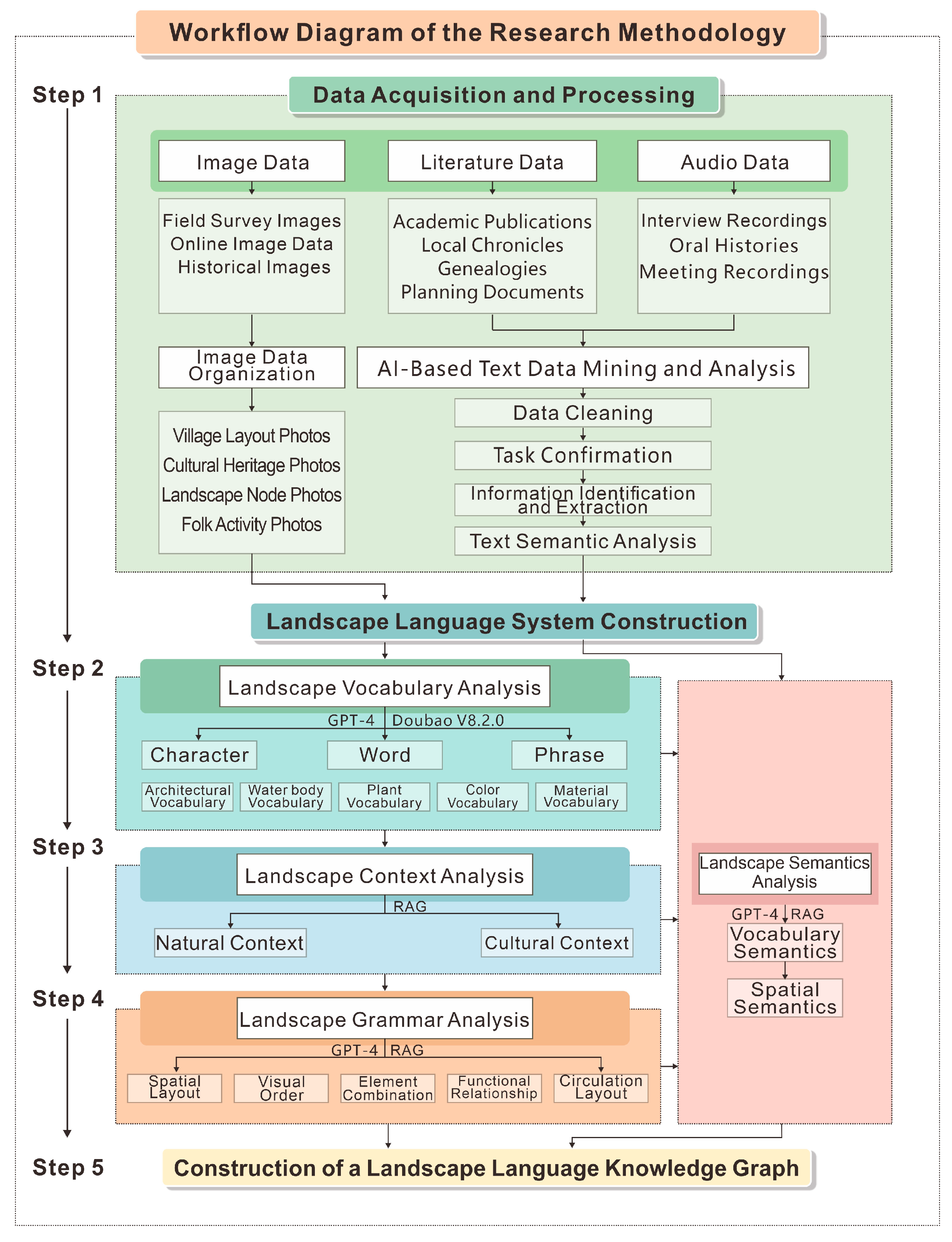
This study constructs a digital interpretation methodology for traditional village landscape language, integrating multimodal artificial intelligence with semantic-enhanced retrieval (SER). It seeks to systematically decipher and semantically interpret the landscape language of Xinye Village in Zhejiang Province through a digital, semantic analytical framework. First, a deep learning-based computer vision model automatically deconstructs collected landscape images of Xinye Village. Through object detection and semantic segmentation algorithms, the model precisely identifies and labels specific landscape elements while extracting high-dimensional deep feature vectors, enabling quantitative representation and feature comparison of visual landscape information. Subsequently, a “Xinye Village Landscape Knowledge Base” is constructed, centered on knowledge-enhanced retrieval. This knowledge base systematically integrates historical documents, academic research, local chronicles, and planning archives related to the village, enabling semantic-level retrieval and generation via the RAG model. Building upon this knowledge base, the AI model generates comprehensive descriptions of landscape semantics and context, cross-comparing them with source materials to ensure the authenticity and academic objectivity of the outputs. The technical route comprises four analytical modules: landscape lexical analysis, landscape contextual analysis, landscape syntactic analysis, and landscape semantic analysis (Figure 2).

2.3.1. Landscape Vocabulary Analysis

(1) Image Data Acquisition and Processing.
① Field Survey Images: Primary visual data of Xinye Village’s landscape was obtained through systematic field surveys. To ensure the spatial representativeness and comprehensiveness of the samples, the stratified random sampling method was employed. Based on the village’s functional spatial pattern, the study area was divided into two subsystems: “natural layer” and “human layer”. Within each layer, systematic photography was conducted along random paths to capture the diversity and typical features of the village landscape. ② Web-Sourced Images: To supplement landscape information from public perspectives, publicly available images were collected from mainstream travel websites, lifestyle service platforms, and local online forums. This dataset reflects the visual orientations and focal points of the public in perceiving, using, and disseminating the village landscape. ③ Image Processing and Classification: All acquired image data underwent manual review by the research team to exclude blurred, duplicated, or irrelevant samples, ensuring data accuracy and validity. Ultimately, 561 high-quality images were selected and categorized into seven groups based on content characteristics: landscape nodes, rural landscape, architectural interiors, wood carving decorations, villagers’ daily life, intangible cultural heritage activities, and others. This established a structured image database of Xinye Village’s landscape, providing a systematic data foundation for subsequent identification of landscape vocabulary and semantic interpretation.
(2) Landscape Vocabulary Recognition and Analysis.
① Landscape Vocabulary Recognition: To ensure the accuracy and objectivity of landscape information interpretation, this study selected three AI visual analysis models with multimodal image recognition capabilities to perform batch recognition and feature extraction on the Xinye Village landscape image database. Leveraging deep visual recognition technology, the models automatically detect and classify landscape elements within images. Following systematic categorization, the study divides recognition results into two primary categories: natural vocabulary and humanistic vocabulary. These are further subdivided into nine subcategories: water bodies, plants, topography, architecture, roads, facilities, intangible cultural heritage crafts, signage systems, and human activities. ② Landscape Vocabulary Analysis: Building upon vocabulary recognition, the study conducted systematic vocabulary analysis for each image using structured prompts. This process extracted and recorded specific names and occurrence frequencies of landscape elements, establishing a quantifiable landscape vocabulary dataset. ③ Vocabulary Information Consolidation and Validation: To enhance reliability and consistency, the research team cross-compared outputs from three AI recognition models through manual review. The model yielding the highest recognition accuracy was selected as the final analytical basis. Following human validation and data cleansing, the “Xinye Village Landscape Vocabulary Information Table” was compiled, providing foundational data support for subsequent landscape context, grammar, and semantic analysis.

2.3.2. Landscape Context Analysis

(1) Establishment of the Raw Corpus.
① Literature Collection: In the landscape context analysis, we first systematically collected multi-source literature related to Xinye Village. These sources included historical archives, academic papers, planning documents, literary works, and curated authoritative media reports. This approach ensured diversity and reliability. We obtained a total of 110 valid documents: 6 books, 9 master’s theses, 71 journal articles, 15 online materials, 1 essay, 4 newspaper articles, and 4 planning documents. ② Information Extraction: Utilizing the RAG model, we extracted relevant content regarding Xinye Village’s natural and cultural environments from the knowledge base. Each piece of extracted content was manually verified against the literature. ③ Corpus Establishment: All extracted text fragments were cleaned, deduplicated, and annotated with their sources and keywords. This process culminated in the construction of the “Xinye Village Landscape Context Corpus”.
(2) Multi-dimensional Context Classification and Feature Induction.
① RAG Model Construction: We used the context corpus as the knowledge source and built a Retrieval-augmented Generation model. This was done by inputting a series of targeted questions about Xinye Village’s natural and cultural aspects. ② Thematic Categorization and Feature Extraction: We systematically summarized landscape context themes for Xinye Village from natural and cultural dimensions. ③ Cross-Validation: We cross-compare RAG outputs against original literature fragments and the landscape vocabulary information table. This ensured the contextual features were well-supported by documentation and aligned with actual conditions.

2.3.3. Landscape Grammar Analysis

Landscape grammar encompasses the combination of landscape elements and spatial composition. First, organize photographic information for a specific spatial node while instructing the AI to replicate all content related to this node from the knowledge base, ensuring keywords are as comprehensive as possible. Subsequently, provide both the images and textual information of the spatial node to a multimodal AI tool. First, have the tool interpret the landscape elements within the images. Finally, instruct the AI tool to conduct a detailed analysis of the principles governing spatial combinations from the photographs and Word documents, focusing on five aspects: spatial layout, visual order, element combination, functional relationships, and circulation layout. Based on the AI’s summary, manually refine and validate the findings by integrating relevant literature.
(1) Image Data Collection and Textual Knowledge Base Compilation.
① Defining Spatial Nodes: Based on the top 20 most frequently occurring landscape vocabulary concepts, identify the five most representative spatial nodes in Xinye Village, including shuikou, squares, buildings, and alleyways. ② Structured Image Collection: Systematically construct a photo collection for each landscape node, including aerial shots, perspective sequences, and element close-ups. Label each photo according to the format “Node A-Aerial-South-to-North Perspective” or “Node B-Circulation Sequence 2”. ③ Deep Aggregation of Textual Knowledge Base: Extract all information regarding landscape elements and spatial attributes for each node from the Xinye Village knowledge base. Require source attribution and manual verification of information.
(2) AI-Assisted Landscape grammar Deconstruction.
① Select three multimodal AI tools (ChatGPT-4, Doubao V8.2.0, and Gemini 3.0) first to identify image-based landscape element features. Core instruction: “Please provide a detailed description of all landscape elements in the provided photo collection. Categorize them into natural elements (plants, water bodies, mountains, terrain, etc.), artificial elements (buildings, paving, structures, facilities, etc.), and abstract elements (color, texture, light and shadow, etc.), listing them accordingly. Additionally, analyze the morphological characteristics of these landscape elements, along with their visual focal points and hierarchical relationships within the frame”. ② Instruct the large model to analyze the structured text and generate an image element list using structured prompts to identify the element combinations and spatial composition characteristics of the landscape node. The core prompt is: You are a senior landscape design expert. You now have the analysis results of a spatial node photo collection (Attachment: Image Element List) and related textual materials (Attachment: Synthesized Landscape Node Knowledge Base). Combine both to conduct a detailed analysis across five dimensions: spatial layout, visual order, element combinations, circulation layout, and functional relationships. ③ Finally, manually inspect whether the AI has misidentified or omitted information. Conduct thorough manual deep verification and refinement to produce the landscape grammar content for the node ultimately.

2.3.4. Landscape Semantic Analysis

Landscape semantics refers to the cultural connotations of landscape vocabulary. Interpreting landscape semantics involves first deciphering the characteristics and cultural connotations of landscape vocabulary, followed by interpreting the cultural significance of the spatial context [23]. Traditionally, interpreting the cultural connotations of village landscapes has relied heavily on researchers’ individual knowledge, experience, and intuition, resulting in significant subjectivity. The integration of AI, with its powerful capabilities in data processing, pattern recognition, and correlation analysis, enables the objective and systematic extraction and presentation of implicit, fragmented, and deep-seated cultural information. The approach is divided into two phases.
(1) Semantic Analysis of Landscape Vocabulary.
This stage transforms visual elements into fundamental vocabulary carrying cultural information. Building upon the preceding image-based landscape vocabulary analysis, it incorporates a custom knowledge base for Xinye Village’s landscape, adding dimensions of feature analysis and cultural connotations to the image interpretation. Through image recognition and knowledge base association, the material characteristics and cultural semantics of landscape vocabulary are interpreted. All parsed results are integrated into a structured “Landscape Vocabulary Information Table”, completing the decoding of landscape vocabulary semantics.
(2) Spatial Semantic Reasoning and Generation.
This phase aims to interpret the macro-narratives and profound cultural logic conveyed by spatial combinations. First, the previously identified landscape vocabulary information, syntactic information, and contextual information are constructed into a multimodal “Village Landscape Semantic Interpretation Knowledge Base”. Subsequently, Retrieval-augmented Generation (RAG) technology is employed. When the system receives a specific set of village spatial images, the RAG framework precisely retrieves lexical, syntactic, and contextual information highly relevant to that space from the semantic interpretation knowledge base. This information is then fed into a large language model, guided by a carefully designed structured prompt template. This template enforces analysis along two progressively deepening dimensions: social function (explaining how the space supports and regulates public life, power structures, and ritual activities) and cultural symbolism (interpreting the cosmology, values, and ideals metaphorically embodied by spatial layouts and element combinations). Ultimately, the AI generates a semantically interpreted landscape report with logical depth and cultural coherence, synthesizing the holistic cultural connotation and core symbolic meaning of the village’s spatial landscape.

2.3.5. Construction of the Landscape Language Atlas

Xinye Village can be regarded as a legible clan narrative embodied in space. Based on the previously interpreted landscape vocabulary, grammar, context, and semantics of Xinye Village, this study employs a linguistic analogy framework of “characters, words, sentences, and paragraphs” to systematically express the intrinsic connections and organizational logic of the village’s landscape elements, thereby constructing a comprehensive landscape language atlas. The construction logic of the map encompasses four primary levels: landscape vocabulary, spatial combinations, public space systems, and the overall village layout.
To more precisely represent this logical structure, this study incorporates artificial intelligence image recognition and generation technology to produce four distinct landscape maps: from the “Vocabulary Map” annotating foundational elements, to the “grammar Map” analyzing spatial organization patterns, then the “Context Map” outlining natural and human environments, culminating in the “Semantic Map” that integrates these to reveal the village’s cultural imagery and spatial narrative. Progressing from micro-elements to macro-patterns, these four maps not only clarify Xinye Village’s landscape structure but also reveal the spatial logic embedded in its “farming and reading passed down through generations” cultural tradition, systematically presenting the profound value of this living cultural heritage.

3. Results

3.1. Results of Landscape Vocabulary Identification

3.1.1. Validation of AI Recognition Results

To validate the reliability of the AI recognition results, this study randomly selected 200 images to form a test set, which was independently annotated by five landscape scholars to establish a validation benchmark. The AI recognition model achieved an average F1 score of 89.8%, an overall accuracy of 90.5%, and a Kappa coefficient of 0.87, indicating a high level of consistency between AI outputs and human judgments. Among these, iconic elements such as horse-head walls, residential dwellings, and the Tuanyun Pagoda achieved excellent recognition performance (F1 > 90%), whereas features such as ancient wells showed relatively lower performance due to variations in size, viewing angle, and occlusion, though the results remained within an acceptable range. These validation results demonstrate that the AI-based approach adopted in this study can objectively and systematically extract landscape vocabularies, providing a reliable data foundation for subsequent analyses.

3.1.2. Composition and Distribution Characteristics of Landscape Vocabulary

Based on verifying the reliability of the proposed method, this study conducted a systematic recognition and feature extraction analysis on the landscape image database of Xinye Village. The analysis focused on identifying the landscape vocabulary and its frequency of occurrence, in order to reveal the compositional characteristics and spatial distribution patterns of the landscape vocabulary. The results indicate that the AI model is capable of effectively extracting multi-level landscape elements from images, thereby reflecting the structural characteristics and cultural connotations of the landscape language of Xinye Village. This provides a robust quantitative foundation for subsequent in-depth interpretation at the levels of context, grammar, and semantics.
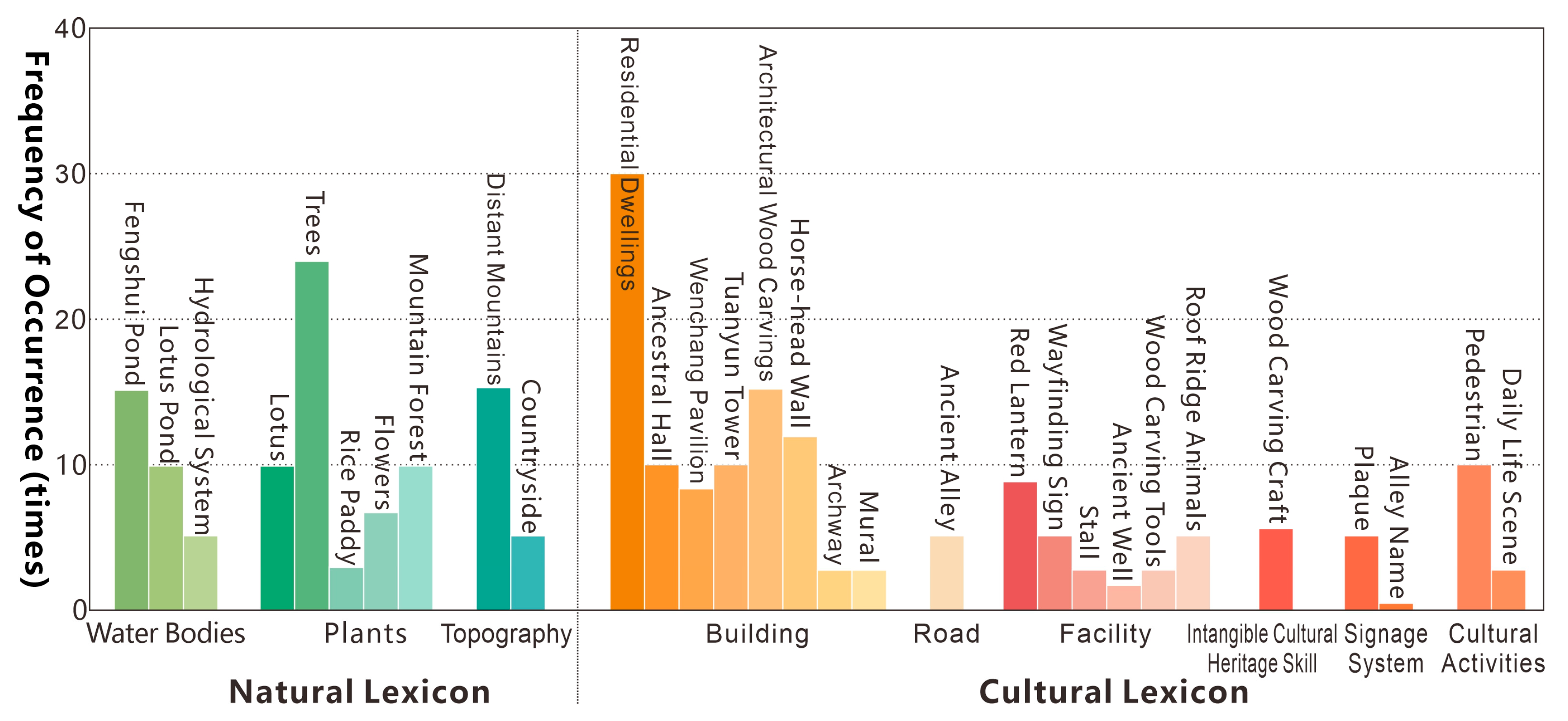
① Natural Lexicon Identification Results: The AI model identified 3 major categories, 9 subcategories, and 31 specific elements within the natural lexicon. The most frequently occurring elements included: forests (25 occurrences), Fengshui Pond (15), distant mountains (15), and lotus ponds (10) (Figure 3). The frequency distribution reveals that plants, water bodies, and mountainous elements significantly outnumber topographical features, indicating that Xinye Village’s landscape pattern is characterized by a “surrounded by mountains and water and densely covered with plant”. The high recognition frequency of Fengshui Pond highlights their central role in both the village’s ecological and cultural structure. They serve as symbolic elements of the village’s fengshui layout and constitute vital landscape vocabulary within the collective memory of the community.
② Humanistic vocabulary Identification Results: Findings were categorized into six major groups—architecture, roads, facilities, etc.—yielding 21 specific vocabulary items. Architectural Vocabulary: High-frequency elements include residential dwellings (30), architectural wood carvings (15), horse-head walls (12), Tuanyun Pagoda (10), and Youxu Hall (10). Findings reveal that Xinye Village’s architectural landscape centers on horse-head wall dwellings, embodying the typical Zhejiang-style architecture. Architectural wood carvings, as the primary decorative vocabulary, reflect the continuity of the village’s wood carving craft tradition. Tuanyun Pagoda, Wenchang Pavilion, and Youxu Hall form the village’s significant vertical landscape vocabulary, serving symbolic and landmark functions. As shown in Table 2, the humanistic vocabulary of Xinye Village’s cultural landscape exhibits a characteristic pattern centered on clan culture, alongside the coexistence of multiple cultural influences, including fengshui culture, farming and reading culture, folk customs, the concept of the unity of Heaven and humanity, and tourism. Clan culture holds the highest proportion (23.3%), primarily manifested in ancestral halls, pagodas, dwellings, and plaque inscriptions, highlighting the village’s patriarchal clan order and kinship structure that have persisted for centuries. fengshui cultural vocabulary accounts for 20.0%, reflecting the fengshui principle of “encircled by mountains and water, with water functioning as the organizing artery” in the village’s spatial layout. Farming and reading culture and folk art culture each constitute 16.7%: the former embodies the “Farming and reading passed down through generations” ideology through agricultural landscapes like rice paddies and lotus ponds, while the latter showcases folk artistic esthetics and cultural confidence through decorative vocabulary such as rosewood carvings and lanterns. The concept of the unity of Heaven and humanity also accounted for 16.7%, emphasizing the harmonious coexistence of the village space with the natural landscape (Table 2). Overall, Xinye Village’s humanistic landscape lexical system combines tradition with adaptability, preserving profound clan and fengshui cultural foundations.

3.2. Results of Landscape Context Induction

Based on a corpus of landscape contexts for Xinye Village, this study employed a Retrieval-augmented Generation model with structured prompts to retrieve and generate natural and cultural landscape contexts for the village.

3.2.1. Natural Context Characteristics

Xinye Village’s natural context exhibits an integrated characteristic where topographical enclosure, hydrological systematics, and ecological culture are mutually coupled. The village’s formation is rooted in its unique intermontane basin topography. The southeastern entrance of the gorge formed by Yuhua Mountain (652 m above sea level) and Daofeng Mountain (517 m above sea level) constitutes a relatively enclosed and complete natural geographical unit spanning approximately 5 square kilometers. This embracing topography not only provided flat valley land for agricultural cultivation but also laid the physical and psychological foundation for the inward cohesion and clustered development pattern of the clan settlement.
Its hydrological system reflects comprehensive adaptation to mountain floods, irrigation, and domestic needs under subtropical monsoon conditions. Through long-term planning, a composite water management network was established, comprising outer streams (for flood discharge and irrigation), inner channels (for domestic water and village drainage), and six ponds (such as Nantang and Shitang, used for water storage, fire prevention, and microclimate regulation) (Table 3). By integrating natural water flows, productive activities, and patriarchal clan order organically, water became a key force shaping the spatial structure.
Simultaneously, the village developed a three-dimensional plant system blending cultivated and natural plant. Natural forests on the surrounding mountains provided building materials, while tea and tung trees were cultivated on the encircling hills. The “fengshui forests” at the water entrance and the trees before the ancestral hall were imbued with ecological functions and cultural symbolism, believed to “safeguard cultural prosperity”. This system profoundly reflects the dual interaction with the natural environment on both material and spiritual levels.
Overall, the natural topography, hydrological Structure, and plant systems synergize across multiple scales, forming the foundational natural framework that sustains Xinye Village’s settlement morphology, spatial organization, and clan structure.

3.2.2. Cultural Contextual Characteristics

Xinye Village’s humanistic context reveals a multi-layered composite structure driven by the patriarchal clan system, forming a self-consistent and stable system among its physical spaces, cultural practices, and value systems. In physical form, the village layout directly materializes the clan structure [25]. It is organized around the chief ancestral hall “Youxu Hall”, with sub-ancestral halls of various branches as secondary nodes, forming a multi-tiered, clustered structure of ancestral halls and residences that strictly adheres to the ethical order of revering ancestors and integrating the clan. Simultaneously, the construction of fengshui structures such as the Cloud-Gathering Tower and Wenchang Pavilion represents the cultural practice of projecting the social ideals of farming and reading culture into the spatial realm. On the intangible level, a comprehensive set of rituals and activities sustains clan identity. Ancestral ceremonies, genealogy compilation, academy establishment, and performances like the Xinye Kunqu opera serve not only as rites reinforcing blood ties but also as pivotal mechanisms for transmitting values and reproducing social structures. At the core of these values, clan ethics centered on filial piety and the life ideal of farming and reading culture jointly shape the villagers’ conservative and stable cultural psyche. This is the fundamental reason for the village’s resistance to external change and its maintenance of high internal cultural continuity, prompting villagers to consciously preserve ancestral homes and spatial rules (Table 4). Overall, Xinye Village’s humanistic context exhibits remarkable systemicity and endogeneity, with its spatial form, cultural traditions, and value structures interlinked, collectively supporting the extraordinary stability of this bloodline-based settlement spanning eight centuries.

3.3. Results of Landscape Grammar Analysis

Based on the aforementioned landscape vocabulary identification results, residential dwellings, horse-head walls, wood carvings, Tuanyun pagoda, Wenchang pavilion, and Fengshui Pond appear most frequently. This indicates that the key nodes of Xinye Village’s landscape structure are concentrated around the shuikou, South Pond, and ancient dwellings. To reveal its landscape grammar, this section first summarizes its grammatical framework at the overall settlement level, then selects the most representative shuikou landscape for detailed analysis.

3.3.1. Overall Settlement Syntactic Characteristics

The overall spatial grammar of Xinye Village exhibits an organizational logic characterized by “a mountain–water foundation, ancestral halls as the core, a network of streets and alleys, and interconnected spatial nodes”. The settlement leverages Yuhua Mountain, Daofeng Mountain, and multi-tiered hydrological systems to form a village layout that “concealing wind and gathering Qi” Cultural nodes such as pagodas, ponds, and ancestral halls construct the skeletal framework of spatial sequences, creating a ritualistic spatial experience of “gazing at the pagoda—entering the pond—walking the street—returning to the ancestral hall”. Village roads and alleys connect functional spaces such as dwellings, ancestral halls, and plazas into a cohesive settlement narrative.

3.3.2. Shuikou Landscape Grammar Characteristics

(1) Spatial Layout.
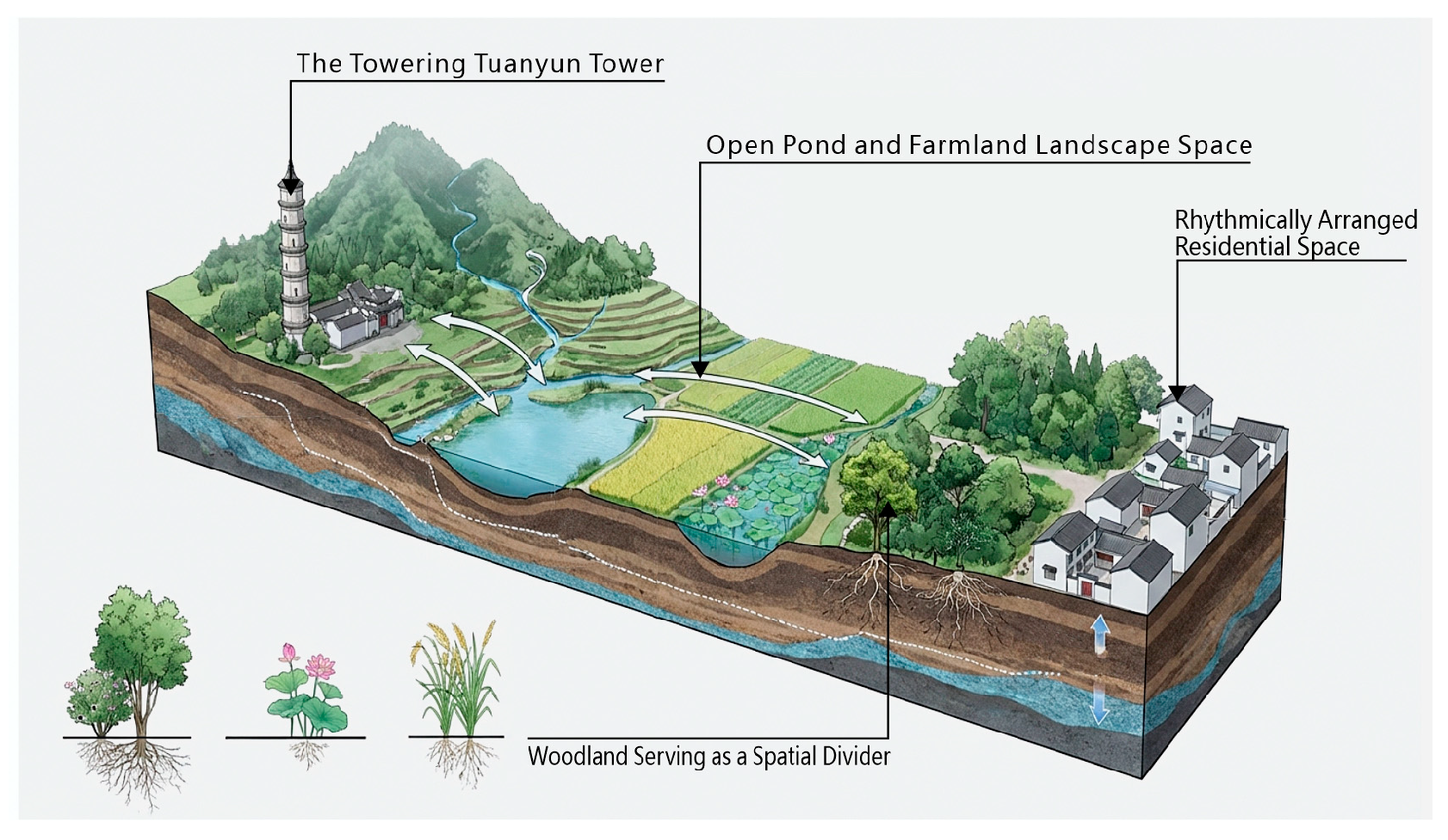
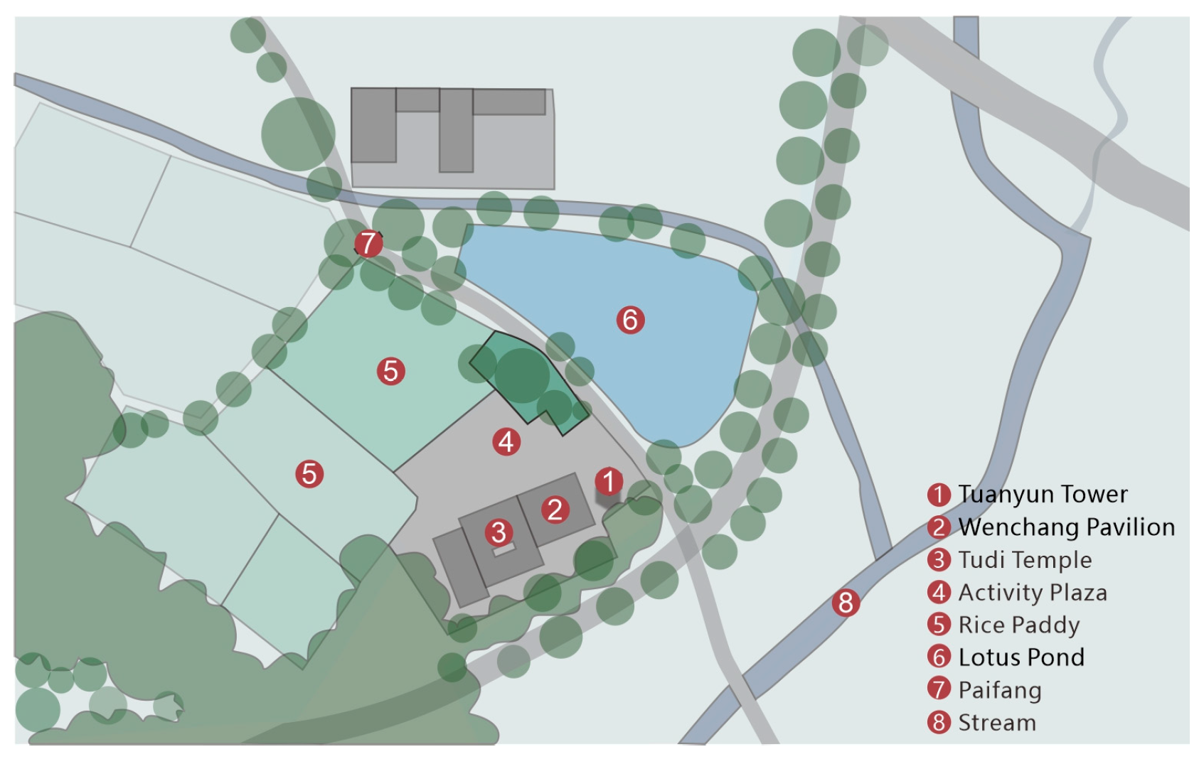
The shuikou is a critical site where the mountain–water configuration, the settlement entrance, and the cultural symbolism of Xinye Village converge. The entrance space is shaped by the convergence of water descending from Yuhua Mountain and the natural enclosure formed by Xiangshan and Shishan, creating a spatial constriction. Positioned at key locations, the Tuanyun Pagoda and the Wenchang Pavilion together form a “gate-locking” system within the traditional fengshui framework (Table 5). The tower, distant mountains, and ancestral halls collectively generate a continuous landscape structure, through which natural topography and cultural landmarks jointly articulate a clearly defined settlement entrance and a symbolic spatial framework (Figure 4).
(2) Spatial Order.
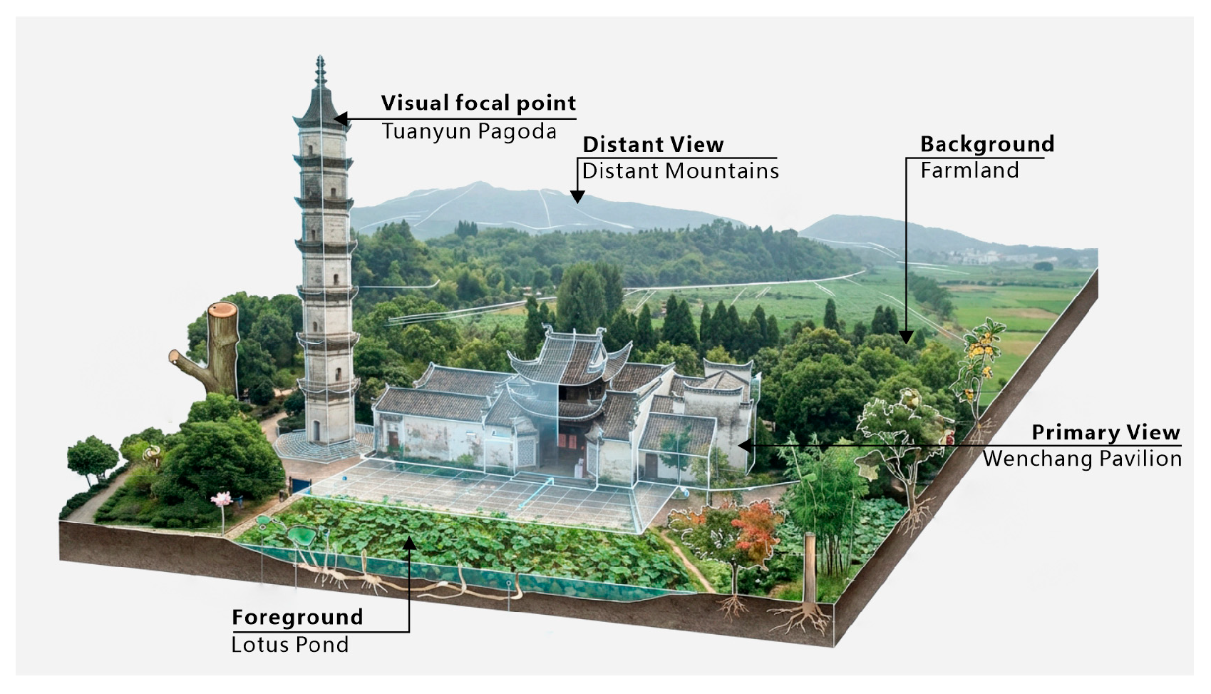
The spatial order of the shuikou unfolds along a primary sequence of “viewing the tower—circulating around the pond—entering the interior”. The Tuanyun Pagoda establishes the initial visual focus, while the lotus pond and adjoining open space mediate the transitional zone leading into the village. The Wenchang Pavilion and the Tudi Temple further reinforce the ritual attributes of the core node. The spatial rhythm shifts from openness to enclosure and from upward-looking to eye-level perspectives, creating a progressively layered entrance experience that reveals the continuous articulation of natural landscape, clan-based ritual order, and overall settlement order.
(3) Element Combination.
The shuikou landscape of Xinye Village comprises a composite landscape system formed by natural elements (such as mountains, lotus ponds, trees, and streams), cultural constructions (including the Tuanyun Pagoda, Wenchang Pavilion, and Tudi Temple), and abstract landscape components (such as color, light, and shadow, and texture) (Figure 5). Its core space is formed by the linear sequence of buildings such as the tower, ancestral hall, and temple, arranged in a “single-line” configuration, serving dual functions of spatial organization and cultural symbolism. The stream flows through the southeast side of the Cloud-Gathering Tower, while ponds and rice fields surround the plaza. Greenery naturally spreads along paths and open spaces. Natural elements serve as framing views, background scenery, and ecological regulators, allowing natural, cultural, and symbolic elements to overlap and coexist within the same space.
(4) Functional Relationships.
The shuikou landscape centers on symbolic and spiritual functions, including the invocation of scholarly prosperity, the safeguarding of the settlement entrance, and the protection of communal well-being. It also incorporates educational functions, as the Wenchang Pavilion historically served as an academy. In addition, the shuikou landscape fulfills everyday public functions such as resting, orientation, and social gathering. The interweaving of symbolic-spiritual meanings and practical uses forms a composite functional structure, which constitutes a defining characteristic of the entrance space of Xinye Village.
(5) Circulation Layout.
Circulation within the shuikou primarily guides entry into the village and structures a sequential spatial experience. The silhouette of the tower functions as a distant visual landmark, directing movement and orientation. Pedestrians pass beneath the tower and along the edge of the pond before entering the internal street network, completing the transition from the external natural environment to the settlement’s core (Figure 6). At the same time, the shuikou landscape serves as the principal transportation node of the village, acting as a critical point for the convergence and redistribution of circulation flows for both residents and visitors.
(6) Scale Relationships.
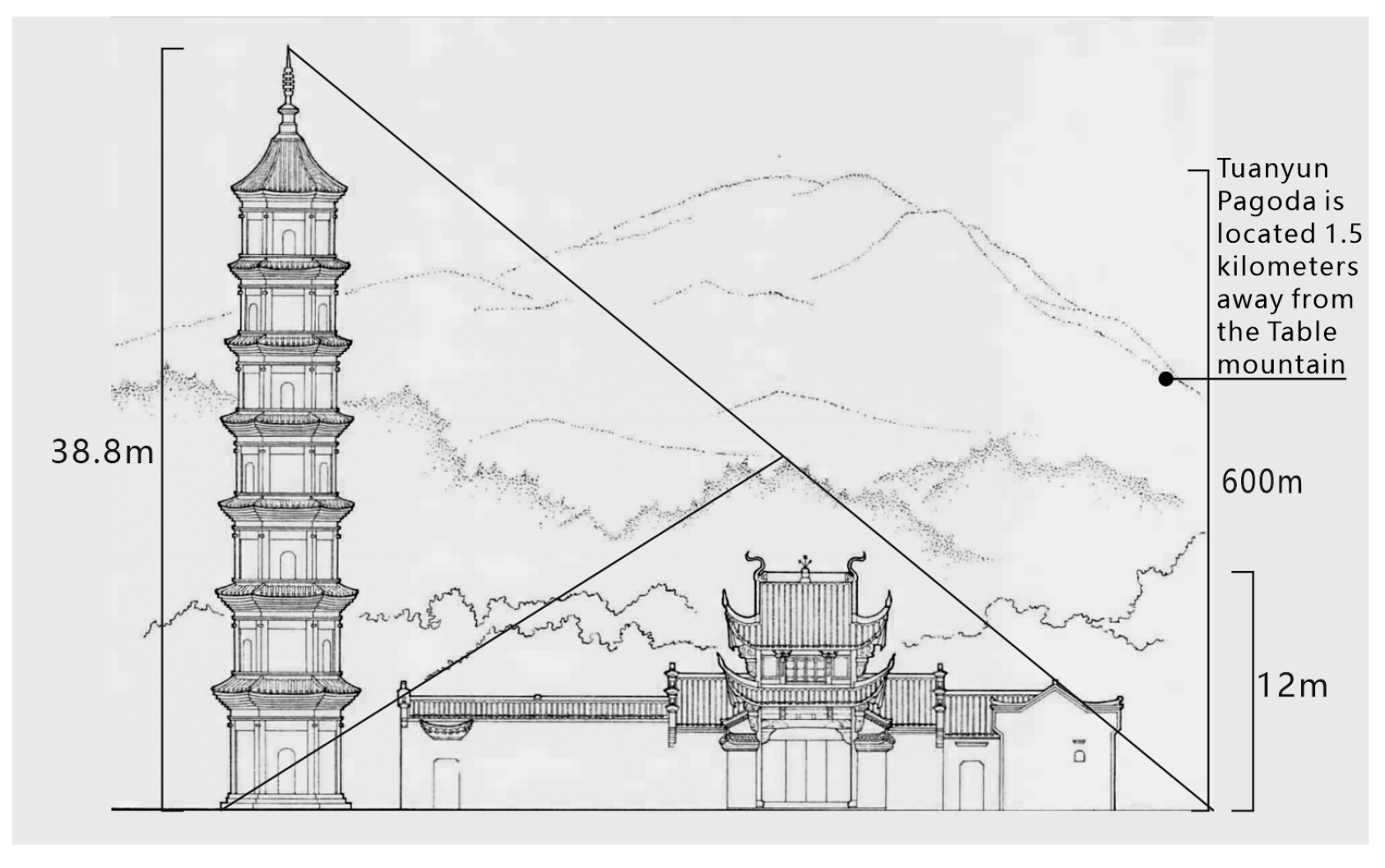
The scale system of the shuikou landscape exhibits a three-tiered alignment among mountains and water, architecture, and pedestrians. Xiangshan and Shishan form an enclosing mountainous setting at the entrance; the Tuanyun Pagoda, Wenchang Pavilion, and Tudi Temple establish a hierarchical architectural sequence from high to low; and the dimensions of plazas, pathways, and courtyards correspond closely to traditional pedestrian use (Figure 7). The coordination of these multi-level scales collectively generates a spatial experience that balances ritual formality with human-scale intimacy (Figure 6).

3.4. Results of Landscape Semantic Interpretation

(1) Semantic Interpretation of Landscape Vocabulary.
Building on the preceding landscape vocabulary analysis and integrating Xinye Village’s landscape knowledge base, the image analysis incorporates dimensions of landscape vocabulary and its cultural connotations. Through image recognition and knowledge-base association, the cultural semantics of Xinye Village’s landscape vocabulary are interpreted from three perspectives: morphological features, functional value, and cultural connotations. These are consolidated into the following “Landscape Vocabulary Semantic Information Table” (Table 6).
Xinye Village’s landscape vocabulary system exhibits an integrated character in which nature and culture intertwine, functionality and symbolism coexist, and material and spiritual elements co-construct the environment. Its natural elements follow the contours of mountains and the flow of water, embodying ecological wisdom that adapts to the geographical layout. Cultural elements, such as ancestral halls, pagodas, towers, and alleys, establish spatial order while carrying fengshui philosophy and clan ethics. The overall landscape emphasizes layered harmony in form, combines practicality with spiritual resonance in function, and integrates the esthetic ideal of “the unity of Heaven and humanity” with the cultural belief of “Farming and reading passed down through generations”. This constructs a traditional village landscape vocabulary system that embodies both ecological rationality and cultural symbolism.
(2) Semantic Interpretation of the Shuikou Landscape in Xinye Village.
The shuikou space of Xinye Village constitutes a cultural narrative system structured by fengshui, animated by the spirit of farming and reading, and anchored by clan solidarity. Its core meaning can be summarized as follows: serving as the village’s “gateway and soul”, Shuikou guides individuals through a spatial narrative of “boundary, transition, core, and resonance”, facilitating their identity shift from “external visitor” to “clan member”; Through the layered functions of “sacred rituals, secular life, and power norms”, it sustains the survival and operation of the clan community; using the symbolic coding of “landscapes, architecture, and artifacts”, it materializes the “cosmology of harmony between heaven and humanity, the values of farming and reading passed down through generations, and the clan perspective of revering ancestors and honoring the past” into tangible landscapes (Table 7). From its essence, this space embodies the crystallization of the Ye family’s centuries-long survival wisdom: it is both a fengshui masterpiece designed to “concealing wind and gathering Qi” and a lived theater of “agricultural-cultural symbiosis”, as well as a spiritual totem of “clan identity”. Ultimately, it stands as a living testament to the tripartite relationships among humans and nature, agricultural-scholarly life, and clan affiliation in traditional Chinese agrarian society. The following sections interpret the semantic dimensions of Xinye Village’s water mouth space through spatial narrative, social function, and cultural symbolism.

3.5. Constructing a Landscape Language Spectrum

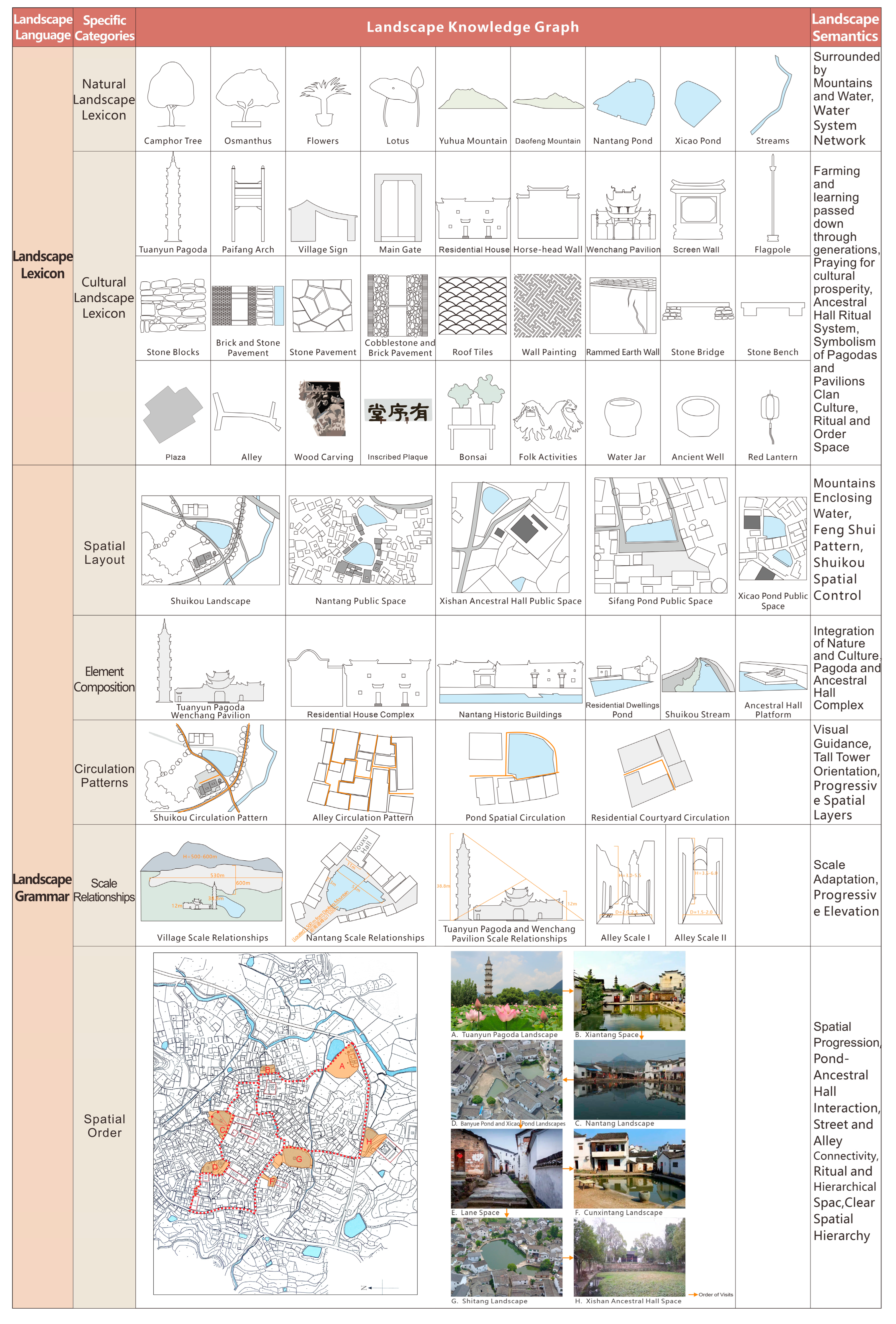
Xinye Village serves as a living text of clan culture and survival wisdom, where its landscape bears not only physical structures but also culturally “readable” meanings [26]. Building upon the identified landscape vocabulary, grammar, context, and semantics, this study aims to systematically construct the intrinsic connections and organizational logic of its landscape language, forming a comprehensive Landscape Language Atlas. The construction of Xinye Village’s landscape atlas follows the structural logic of “linguistics”, incorporating artificial intelligence image recognition and generation technologies to map a four-dimensional landscape atlas. This reveals the structure and connections from foundational elements to macro-scale settlement narratives (Table 8). The following figure details the content of Xinye Village’s landscape language atlas (Figure 8).

4. Discussion

This study introduces artificial intelligence technology into the analysis of traditional village landscape language, constructing a comprehensive framework for interpreting landscape discourse. Taking Xinye Village in Zhejiang as a case study, it has achieved substantial progress in both theoretical deepening and methodological innovation.

4.1. AI-Driven Methodological Innovation

Compared to traditional methods of interpreting rural landscape language that rely on manual surveys, textual verification, and expert experience, AI-based information repository construction and multimodal analysis provide a more efficient, systematic, and in-depth technical pathway for landscape research [27]. AI can process vast amounts of heterogeneous data—including images, text, and spatial information—in a short time, enabling automatic recognition, frequency statistics, and pattern extraction of landscape elements. This overcomes the limitations of manual analysis, including sample size, subjective bias, and cross-dimensional correlations.
Simultaneously, AI-driven repositories of rural landscape information enable the structured integration of cultural elements, spatial forms, and environmental characteristics. This facilitates hierarchical expression of landscape vocabulary, grammar, context, and semantics within a unified data framework, revealing multidimensional systemic connections among rural landscape structures, spatial logic, and cultural significance [28]. More importantly, deep learning models can automatically extract latent morphological and spatial characteristics from large-scale visual data, revealing potential spatial structures and element combination patterns that are difficult to identify through traditional manual methods. This provides new quantitative evidence and interpretive frameworks for deciphering landscape morphological patterns and deep semantic meanings [29]. Therefore, artificial intelligence not only enhances interpretive efficiency and objectivity but also deepens and broadens the scope of traditional landscape-language research, providing a more scientific analytical framework for studying the structural, regular, and evolutionary mechanisms of village landscapes.

4.2. Theoretical Innovation and Practical Value of the Landscape Language System

The four-tiered landscape language analysis framework—comprising vocabulary, grammar, context, and semantics—developed in this study achieves an organic integration of theoretical expansion and practical application [30]. Compared to traditional research focused on morphological classification and singular symbolic interpretation, this framework transcends superficial descriptions by deeply integrating “form and meaning”. It provides a structured analytical pathway for the spatial logic and cultural symbols embedded in traditional settlement landscapes, enriching the research paradigm of landscape linguistics while bridging cultural interpretation with spatial quantification [31]. Simultaneously, this system—along with AI-generated landscape atlas and a digital knowledge repository—provides scientific support and practical guidance for Xinye Village’s landscape conservation, renewal, restoration design, and rural revitalization. Its derived applications extend to dynamic monitoring of traditional landscapes, cross-village comparative analysis, and visualization of cultural evolution, establishing a support system for rural heritage preservation that combines theoretical depth with long-term utility.

4.3. Limitations of AI in Cultural Semantic Analysis

Although artificial intelligence demonstrates high efficiency and accuracy in the recognition of landscape elements and the extraction of spatial features, certain limitations remain in the deep interpretation of cultural semantics and symbolic metaphors [32]. Existing models are primarily trained on visual and textual data; when sufficient cultural context is lacking, they encounter difficulties in accurately interpreting the symbolic meanings, historical allusions, and ritual significance embedded in landscape elements [33]. For example, artificial intelligence can identify elements such as ancestral halls and pagodas; however, without the support of cultural context, it cannot fully comprehend their symbolic roles in village social structures, such as the representation of clan order and Fengshui layout. Moreover, this study takes Xinye Village—where documentation and data are relatively complete—as a case study. For villages with incomplete historical records or limited available information, constraints in data acquisition may also affect the accuracy and reliability of analytical results.

4.4. Recommendations for AI-Assisted Cultural Semantic Interpretation

To systematically address the limitations of artificial intelligence in cultural semantic analysis, future research can advance methodological optimization from two dimensions: knowledge enhancement and human–machine collaboration, thereby constructing a more interpretable analytical framework for landscape language. First, an integrated human–machine collaborative analytical model should be established. By combining the advantages of artificial intelligence in large-scale data processing and pattern recognition with the expertise of domain specialists in historical and cultural interpretation and contextual judgment, it is possible to maintain analytical objectivity while ensuring the accuracy and depth of semantic interpretation. Second, a knowledge-enhanced semantic support system oriented toward traditional villages should be developed. Through the systematic integration of landscape vocabulary data, spatial structural information, historical documents, and local socio-cultural materials, a structured knowledge network with hierarchical relationships and semantic associations can be constructed, forming a computable cultural context model [34]. Finally, the long-term development of a multi-source data infrastructure for traditional villages should be strengthened. Based on systematic field investigations, the compilation of local historical records, and multimodal data collection, a relatively comprehensive traditional village database can be established, providing a stable data foundation for artificial intelligence model training and semantic mapping.

5. Conclusions

Taking Xinye Village in Zhejiang Province as a representative case, this study, grounded in landscape language theory, constructs an analytical framework for traditional village landscape language that integrates multimodal artificial intelligence with Retrieval-augmented Generation. This framework enables systematic and interpretable analysis across the stages of landscape vocabulary identification, Spatial grammar analysis, and landscape semantics interpretation. By establishing a four-level progressive analytical path, namely, vocabulary, context, grammar, and semantics, the study digitally reconstructs and visually presents the spatial narrative structure and underlying cultural genes of traditional village landscapes.
Empirical analysis indicates that Xinye Village has developed a well-structured and hierarchically organized landscape language system. At the level of landscape vocabulary, computer vision and image data analysis identify 31 core natural and cultural elements across three major categories and nine subcategories, revealing a landscape compositional foundation dominated by clan institutions and Fengshui culture. At the level of landscape context, the village is structured around the natural framework of Yuhua Mountain, Daofeng Mountain, and the water system, while simultaneously forming a humanistic structure centered on clan order and the tradition of farming and scholarly. The integration of natural and social contexts jointly supports the long-term stability and development of the settlement. At the level of landscape grammar, the spatial configuration of the village follows an organizational logic characterized by “mountains and water as the foundation, ancestral halls as the core, streets and lanes as the network, and nodes as connectors”. A ritualized spatial narrative sequence—“viewing the pagoda, entering the pond, walking through the streets, and returning to the ancestral hall”—further structures the spatial experience. At the level of landscape semantics, the landscape system not only accommodates functions of production and daily life but also embodies the ecological philosophy of harmony between humans and nature and the clan-based ethic of farming and reading passed down through generations. This reveals a settlement pattern in which the natural environment, social structure, and cultural values are highly coupled. Overall, Xinye Village has formed a composite cultural landscape system characterized by reliance on natural mountains and water, a clan-based social order at its core, Fengshui culture as its structural schema, and farming and reading culture as its spiritual foundation.
Compared with previous studies on landscape language, this research has made certain innovations in both theory and methods. Theoretically, it proposes a four-tiered landscape language structure model—vocabulary, grammar, context, and semantics—expanding the conceptual framework of landscape language from visual form analysis to deep cultural-semantic construction. Methodologically, this study incorporates AI-driven multimodal computation and semantic-enhanced retrieval techniques. By integrating expert validation with AI recognition outcomes, it shifts landscape language research from experience-driven to data-driven approaches, significantly enhancing scientific rigor, objectivity, and analytical efficiency. AI-assisted analysis has enabled feature extraction and semantic matching of massive amounts of landscape information, opening new pathways for the systematic identification of cultural landscapes in traditional villages.
Overall, this research not only provides a systematic methodology and theoretical foundation for interpreting traditional village landscape language but also pioneers new technical pathways for cultural landscape conservation and adaptive reuse. The established landscape language lexicon offers a scientific basis and decision support for heritage digital preservation, landscape heritage database development, cultural landscape evaluation, and rural renewal design. The introduction of this research framework signifies that traditional village landscape studies are evolving from qualitative descriptions toward an integrated phase of intelligence, semantics, and visualization. It offers a new academic paradigm and practical direction for achieving the sustainable inheritance of China’s traditional cultural landscapes.

Author Contributions

Conceptualization, Y.L. and Z.H.; methodology, Y.L. and Z.H.; software, T.C.; validation, Y.L.; formal analysis, Y.L.; investigation, T.C.; resources, Y.L.; data curation, T.C.; writing—original draft preparation, Y.L.; writing—review and editing, Y.L. and Z.H.; visualization, T.C.; supervision, Z.H.; project administration, Y.L.; funding acquisition, Y.L. All authors have read and agreed to the published version of the manuscript.

Funding

Research on the Deconstruction and Design Strategies of Cultural Landscapes in Zhejiang Traditional Villages Based on Landscape Language, Post-funded Project of Zhejiang Provincial Philosophy and Social Sciences Planning, 25HQZZ009YB. Research on the Theory and Practice of Harmonious and Beautiful Village Landscape Design under the Perspective of Mutual Learning Among Civilizations, Annual Project of National Social Science Fund of China (Art Studies), 25AG021.

Institutional Review Board Statement

Not applicable.

Informed Consent Statement

Not applicable.

Data Availability Statement

Data are contained within the article.

Conflicts of Interest

The authors declare no conflicts of interest.

References

  1. Zuo, T. Tourism development models and optimization strategies for traditional Chinese villages. People’s Forum 2024, 33, 102–106. [Google Scholar]
  2. Alexander, C. A Pattern Language: Towns, Buildings, Construction; Oxford University Press: New York, NY, USA, 1977. [Google Scholar]
  3. Spirn, A.W. The Language of Landscape; Yale University Press: New Haven, CT, USA, 1998. [Google Scholar]
  4. Steiner, F. The Living Landscape: An Ecological Approach to Landscape Planning; China Architecture & Building Press: Beijing, China, 2005. [Google Scholar]
  5. Fujii, A. Exploring Settlements; China Architecture & Building Press: Beijing, China, 2003. [Google Scholar]
  6. Hara, H. Journey to the Villages; China Architecture & Building Press: Beijing, China, 2005. [Google Scholar]
  7. Boults, E.; Sullivan, C. Illustrated History of Landscape Design; Tianjin University Press: Tianjin, China, 2013. [Google Scholar]
  8. Yu, K.J. The Meanings of Landscape. Time Archit. 2002, 1, 14–17. [Google Scholar]
  9. Su, X.G. The Illusion of Materialism: Theme Parks in Pop Art and Mass Culture. Chin. Landsc. Archit. 2002, 3, 20–23. (In Chinese) [Google Scholar]
  10. Meng, X.Y. Nordic Modernist Landscape Architecture Design Language Research: 1920–1970. Ph.D. Thesis, Beijing Forestry University, Beijing, China, 2006. (In Chinese) [Google Scholar]
  11. Chen, S.H. Landscape Meaning Construction and Communication: The Application of Language Symbol Theory in Landscape Design; China Forestry Publishing House: Beijing, China, 2017. [Google Scholar]
  12. Wang, Y.C.; Han, L.Y.; Xu, J. Schema Language of Water Habitat Design and Its Application. Chin. Landsc. Archit. 2012, 28, 56–61. (In Chinese) [Google Scholar]
  13. Qiu, B. Landscape Design Language: A Study on the Localization of Modern Landscape Architecture Design Language in China (1949–2009); Southeast University Press: Nanjing, China, 2018. [Google Scholar]
  14. Li, B.H.; Cheng, B.; Dou, Y.D. Analysis of Schema Language and Restoration Path of Traditional Dong Villages in Western Hunan. Acta Geogr. Sin. 2025, 80, 828–850. (In Chinese) [Google Scholar]
  15. Wang, Z.; Zhuang, Q.; He, X. The Construction Mechanism of Landscape Patterns: A Case Study of Traditional Villages in the Pearl River Delta Region. J. Asian Archit. Build. Eng. 2025, 24, 1–20. [Google Scholar] [CrossRef]
  16. Nauata, N.; Chang, K.-H.; Cheng, C.-Y.; Furukawa, Y. House-GAN: Relational Generative Adversarial Networks for Graph-Constrained House Layout Generation. In Proceedings of the European Conference on Computer Vision (ECCV), Glasgow, UK, 23–28 August 2020; Springer: Cham, Switzerland, 2020; pp. 62–77. [Google Scholar]
  17. Günay, E.; Mayuk, S.G. A Research on the Use of Machine Learning on Building Facades. Eur. J. Res. Dev. 2022, 2, 224–240. [Google Scholar] [CrossRef]
  18. Cappellazzo, M.; Patrucco, G.; Sammartano, G.; Baldo, M.; Spanò, A. Semantic Mapping of Landscape Morphologies: Tuning Machine Learning for Landscape Interpretation. Remote Sens. 2024, 16, 3572. [Google Scholar] [CrossRef]
  19. Suppakittpaisarn, P.; Lu, Y.; Jiang, B.; Slavenas, M. How Do Computers See Landscapes? Comparisons of Eye-Level Greenery Assessments Between Computer and Human Perceptions. Landsc. Urban Plan 2022, 227, 104547. [Google Scholar] [CrossRef]
  20. Zhang, R.; Zhang, Z.; Zhang, W.; He, L.; Zhu, C. Deep Learning-Driven Semantic Segmentation and Spatial Analysis of Quarry Relic Landscapes Using Point Cloud Data: Insights from the Shaoxing Quarry Relics. Herit. Sci. 2025, 13, 77. [Google Scholar] [CrossRef]
  21. Li, Q.; Chen, Z. Xinye Village; Tsinghua University Press: Beijing, China, 2011; pp. 15–22. [Google Scholar]
  22. Wang, Y. Pattern Language: A New Approach to Landscape Expression and Spatial Reasoning; China Architecture & Building Press: Beijing, China, 2019. [Google Scholar]
  23. Chen, S. Construction and Communication of Landscape Meaning: Applications of Linguistic Semiotic Theory in Landscape Design; China Forestry Publishing House: Beijing, China, 2017. [Google Scholar]
  24. Wang, R. Spatial Morphology of Xinye Village in Zhejiang Province Based on Space Syntax; Anhui University of Finance and Economics: Anhui, China, 2023. [Google Scholar]
  25. Wang, Y. Interpretation and Modern Adaptation of Jiangnan Vernacular Landscape Language from the Perspective of Structuralism Linguistics; Zhejiang University: Zhejiang, China, 2022. [Google Scholar]
  26. Claval, P. Reading the Rural Landscapes. Landsc. Urban Plan 2005, 70, 9–19. [Google Scholar] [CrossRef]
  27. Zhang, K.; Ning, J.; Gao, Q. Evaluation of the Effect of Rural Landscape Design Based on Hierarchical Analysis and Artificial Intelligence Technology. In E3S Web of Conferences; EDP Sciences: Les Ulis, France, 2024. [Google Scholar]
  28. Hu, Z.; Strobl, J.; Min, Q.; Tan, M.; Chen, F. Visualizing the Cultural Landscape Gene of Traditional Settlements in China: A Semiotic Perspective. Herit. Sci. 2021, 9, 115. [Google Scholar] [CrossRef]
  29. Albert, A.; Kaur, J.; Gonzalez, M.C. Using Convolutional Neural Networks to Analyze Urban form at a Large Scale. Comput. Environ. Urban Syst. 2017, 64, 273–284. [Google Scholar]
  30. Zhang, B. The Schematic Language of Public Spaces in Traditional Villages; China Building Materials Industry Press: Beijing, China, 2023. [Google Scholar]
  31. Tveit, M.; Ode, Å.; Fry, G. Key Concepts in a Framework for Analysing Visual Landscape Character. Landsc. Res. 2006, 31, 229–255. [Google Scholar] [CrossRef]
  32. Qadri, R.; Shelby, R.; Bennett, C.L.; Denton, E.R. AI’s Regimes of Representation: A Community-Centered Study of Text-to-Image Models in South Asia. arXiv 2023, arXiv:2305.11844. [Google Scholar]
  33. Huang, Y.; Yu, S.; Chu, J.; Fan, H.; Du, B. Using Knowledge Graphs and Deep Learning Algorithms to Enhance Digital Cultural Heritage Management. Herit. Sci. 2023, 11, 204. [Google Scholar] [CrossRef]
  34. Shi, J.; Chai, H.; An, X. The Text Construction of Poetry Road Rural Landscape from the Perspective of Language Landscape—Taking Lutian Village as an Example. Creat. Des. 2020, 3, 12–17+40. [Google Scholar]
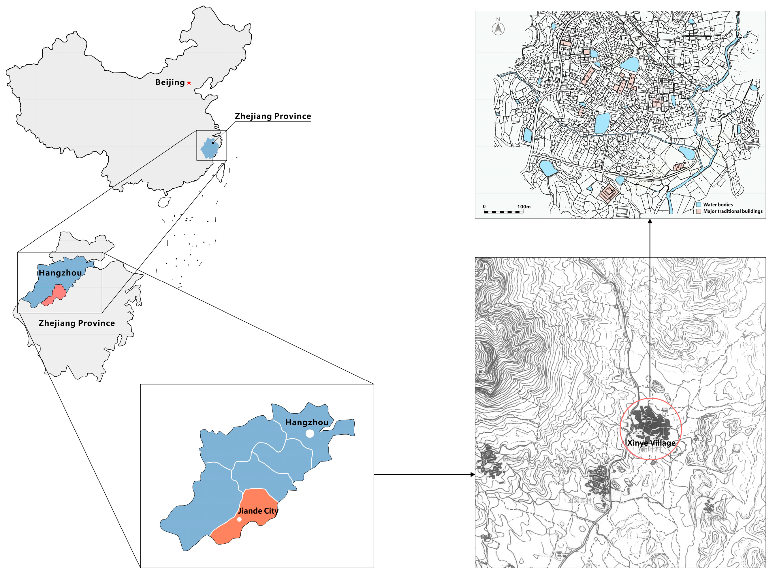
Figure 1. Location Map of the Study Area.
Sustainability 18 02183 g001
Figure 2. AI-Based Interpretation Process of Landscape Language in Traditional Villages.
Sustainability 18 02183 g002
Figure 3. Bar chart of occurrence frequency of landscape vocabulary in Xinye Village.
Sustainability 18 02183 g003
Figure 4. Spatial pattern analysis of the shuikou landscape in Xinye Village.
Sustainability 18 02183 g004
Figure 5. Analysis diagram of shuikou landscape elements in Xinye Village.
Sustainability 18 02183 g005
Figure 6. Visual order analysis diagram of shuikou landscape in Xinye Village.
Sustainability 18 02183 g006
Figure 7. Analysis of landscape scale relationships at the shuikou of Xinye Village.
Sustainability 18 02183 g007
Figure 8. Landscape language atlas of Xinye Village.
Sustainability 18 02183 g008
Table 1. Summary of Research Data Sources.
Data TypeSource Platform and ChannelTime and
Batch
Data ContentData VolumeFormatPrimary Use
Field Research FootageField research in Xinye Village (Lanxi City, Zhejiang Province)2010
2018
2024
Village spatial layout, Architectural details, Natural landscape215 sheetsJPG/RAWAI image recognition, Lexical statistics
Internet imageryFlickr, 500px, Weibo, Xiaohongshu, WeChat Official Accounts, Google Earth, Baidu Maps2019–2024Overall village landscape, Visitor perspective imagery271 sheetsJPG/RAWScene supplementation, Perspective verification
Documentary archives«Lanzhou County Annals» «Jinhua City Historical and Cultural Materials» «List of Traditional Villages in Zhejiang» «People’s Daily» «National Geographic China»1950–2024Village history, Cultural context, Landscape evolution124 copiesPDF/RISModel training and validation
Academic LiteratureWeb of Science, CNKI, Wanfang Data, Google Scholar1980–2025Landscape language related literature130 articlesPDF/RISTheoretical framework support
Comparison samplesDongziguan, Shenao, Furong Village2023–2024Images of surrounding villages200 sheetsJPGRegional comparative analysis
Table 2. AI-Based image recognition statistics of cultural landscape vocabulary in Xinye Village.
Cultural ThemeNumber of Elements Involved (Count of Distinct Elements)Proportion (Ratio of the Number of Elements Involved to the Total Number of Elements)Representative Element Examples
Clan Culture723.30%Ancestral hall, Tuanyun Pagoda, Plaques (Jinshi, Youxu Hall), residential dwellings
Fengshui Culture620.00%Fengshui pond, hydrologic system, roof ornaments (to ward off evil spirits), distant mountains
Farming and reading culture516.70%Rice paddy, field, lotus ponds, lotus
Folk Culture516.70%Red lanterns, wall murals, architectural wood carvings, wood carving craftsmanship
The concept of the unity of Heaven and humanity516.70%Fengshui Pond (Reflected dwellings, distant mountains) Ancient Alley (Blending with nature) Trees
Tourism Culture26.70%Tourist Information Map, Booth
Table 3. Summary analysis of natural context characteristics in Xinye Village.
Primary CategorySecondary IndicatorsCore FeaturesImpact on Village Spatial and Ecological Features
Village Topography and Spatial PatternsLandform typesLocated between Yuhua Mountain and Daofeng Mountain at the northern edge of the Jinqu Basin, it forms a closed basin surrounded by mountains, with higher elevations in the northwest and lower elevations in the southeast.Forming stable, independent natural units that provide protective terrain and arable land
Mountain structureBacked by Yuhua Mountain and facing Daofeng Mountain, the area is embraced by a “necklace-like” ring of small hills including Qianshang Hill, Gulou Hill, Huayuan Hill, and Xishan Hill [24].Establishing the traditional feng shui ideal of a village oriented “facing north with its back to the south”, forming the ideal layout of ancestral mountain, protective mountain, and facing mountain
Settlement layoutThe enclosed topography reinforces a sense of clan boundaries, with a compact, hierarchical spatial structure centered on the ancestral shrinePromote cohesion within clans, deepen the inward-looking nature and sense of belonging within settlements
Climate and Hydrological SystemsClimate characteristicsWarm and humid, with abundant sunshine and rainfall, the area is surrounded by mountains on three sides, which regulate the local climate and create a unique subtropical monsoon microclimateOffers favorable agricultural conditions, but also carries the risk of flash floods
Hydrological system StructureA composite water network comprising external streams (for irrigation and drainage), internal canals (for village-wide domestic water supply and drainage), and six major pond systemsComprising a composite system for domestic water supply, irrigation, drainage, fire protection, and microclimate regulation
plant and EcosystemsMountain plantThe surrounding hillsides retain natural forests and secondary forests, while the ridges are planted with economic tree species such as tea, tung trees, and citrusEstablish a sustainable mountain ecological economic system that provides building materials and fuel
Fengshui forestMaple trees and cypresses are planted in the fengshui forests at the shuikou between Lion Hill and Elephant Hill, serving to “retaining and securing internal qi”. The camphor tree groves and cypress forests at the village entrance form the landscape of the village gateway and mark its boundariesCombining soil stabilization and water retention, microclimate regulation, and symbolic fengshui functions
Greenery within the villageVegetable gardens, courtyard landscaping, pond ecological patches, traditional plum gardens, bamboo groves, and other landscapesMaintaining ecological balance and livability in high-density settlements, embodying the farming and reading culture
Table 4. Summary analysis of cultural context characteristics in Xinye Village.
Primary CategorySecondary IndicatorsCore FeaturesThe Spatial and Social Impacts on Villages
System of Material FormsSettlement structureThe hierarchical cluster settlement centered around the ancestral hall, with the main hall “Youxu Hall” commanding the entire village, while each branch family forms secondary clusters centered around their respective branch hallsEstablishing strict clan-based zoning and spatial hierarchies to enhance the cohesion and inward-looking nature of settlements
Spatial organizationThe residences are densely clustered around the clan hall and pond, with winding alleys that vary in width and layoutThe alleyways serve both as circulation routes and as boundaries between lineage branches, forming a “labyrinthine” internal structure
Fengshui layoutWith Mount Yuhua (ancestral mountain) at its back and Mount Daofeng (facing mountain) before it, the Tuanyun Pagoda and the Wenchang Pavilion are positioned at the shuikouStrengthening the symbolic order and cultural identity of settlements, fengshui nodes become public and ceremonial spaces
Public nodeshuikou landscape, Nantang, stage, alleyways, etc.Serving dual functions in both ceremonial practices (ancestor worship, village theater performances) and daily life (laundry, fire prevention)
Intangible Cultural SystemSacrificial rites and ceremonial practicesPeriodic rituals, such as the ‘Third Day of the Third Lunar Month’ ancestral temple fair and deity-procession festivals, are characterized by rigorous ritual protocols and a high degree of organizational structure.Strengthening clan authority and ethnic identity creates a demand for ritualistic functions in public spaces
Performing artsXinye Kunqu’ (Grassroots Kunqu) is integrated into clan rituals and celebratory eventsAncestral halls must incorporate a stage and viewing area, with cultural activities woven into the fabric of the settlement
Traditional craftsmanshipWood carving, straw weaving, and earthenware liquor production, among other handicraftsCreate distinctive production environments while preserving living spaces rich in cultural charm
Value SystemPatriarchal conceptHonor ancestors, uphold clan rules, and preserve the uniqueness of bloodline-based settlementsFor centuries, the architectural layout remained stable, with clan boundaries clearly defined and strongly exclusive
The value of farming and readingThe ideal of “Farming and reading passed down through generations” flourished with the rise of academies and private schools, while the Wenchang Pavilion and Tunyun Pagoda symbolized literary fortuneThe emphasis on education is spatially expressed, forming a cultural landscape that values literature and education
Respect for eldersConstructing grand ancestral halls and conducting solemn rituals tightly intertwine blood ties with spatial order and social powerThe residence was built adjacent to the ancestral hall of this family, forming an integrated complex of ancestral hall and residence that established a stable spatial layout
Table 5. Multidimensional quantitative analysis of shuikou landscape grammar in Xinye Village.
Analysis DimensionsSystem ComponentsNumerical Values and DescriptionsSyntactic Features
Spatial Patternorientation of the shuikouSoutheast of the villageForming a fengshui pattern where water converges in the southeast, acting as the “earth gate” to retain and secure vital energy
Locked patterngourd-shaped neckFormed jointly by the natural enclosure of Xiangshan and Shishan and by built structures, this configuration reinforces the effect of gathering and retaining qi
Spatial OrderVisual focal heightTuanyun Pagoda 38.8 mThe Tuanyun Pagoda has become the central landmark and directional guide for the village
Spatial structureForeground—Midground—BackgroundStandard visual hierarchy, enhanced depth of field, guiding the perceptual flow from scenery to immersion
Element CombinationCore building complexTowers, pavilions, shrinesThe core structures are arranged in The core buildings are arranged in a linear, ‘single-axis’ sequence. Within this configuration, the tower embodies scholarly prosperity and symbolic meaning, the pavilion serves ritual and educational functions, and the shrine is associated with communal protection and territorial guardianship.
Elemental composition typeNatural, Artificial, AbstractComposed of three types of elements, each fulfilling multiple roles including ecological functions, cultural functionality, and atmosphere creation
Functional relationshipFunction priorityMental Functions—Practical FunctionsThe fundamental driving force behind construction stems from fengshui and psychological aspirations, with practical functionality serving as its extension and complement
Core practical featuresCultural Education, Leisure, TransportationMaterializing spiritual spaces into educational venues, public spaces, and transportation hubs
Circulation layoutStreamline sequenceView from afar—Approach—Pass through—EnterA complete “prologue-style” spatial experience sequence, facilitating psychological transition
RoleMain Entrance and Exit of the VillageServe as the core hub for internal and external transportation connections and the distribution of passenger flows
Scale RelationshipMountain scale (relative height)Elephant Mountain, Lion Mountain: 30–50 mForming a suitable proportion with the village’s scale, achieving effective enclosure without a sense of oppression
Main mountain scale (elevation)Yuhua Mountain: 652 m Daofeng Mountain: 517 mAs a macro backdrop, it creates visual balance with the Tuanyun Pagoda
Building heightThe Tuanyun Pagoda has a height of 38.8 m, the Wenchang Pavilion is approximately 12 m high, and the Tudi Temple is approximately 6 m in heightForming a scale gradient of “soaring-sprawling-low-lying” that aligns with their respective spiritual and practical requirements
human-scale spatial dimensionThe courtyard is approximately 5 m wide, with a stone path measuring 1.2 to 1.5 m in width. The shoreline is about 2 m awayPrecision-optimized human dimensions tailored for group activities, transportation, and safe viewing
Table 6. Semantic information table for the landscape vocabulary of Xinye Village.
CategoryLandscape VocabularyMorphological CharacteristicsFunctional ValueCultural Connotation
Natural ElementsFengshui Pond (e.g., South Pond)Crescent-shaped or geometric form; Features stone-slab washing steps; Reflects surrounding architecture and mountain rangesMulti-functional: Daily washing, firefighting, irrigation, aquaculture; regulating microclimate and water flowThe core of ritual space; symbolizing cultural prosperity (“Dragon Pool Bathing Inkstone”); serving as a communal living room embodying clan harmony
Water systems (streams, irrigation canals)“Double Stream Structure” (inner stream/outer stream); irrigation channels form a network along streets and alleysWater supply, drainage, and sewage disposal; serving a function similar to urban roads in dividing spacesEmbodies ecological wisdom of “adaptation to nature” and the planning concept of “the Five Elements and the Nine Palaces”; reflects clan organizational strength
Distant mountains (e.g., Daofeng Mountain)The village is nestled at the mouth of the gorge formed by Yuhua Mountain and Daofeng Mountain, presenting a basin-like topographyProvide natural barriers and resources (timber, water sources)Core of the feng shui layout; Daofeng Mountain, as a “wenbi peak”, symbolizes aspirations for success in the imperial examination system
Humanistic FactorsTuanyun Pagoda (Wenfeng Tower)A seven-story hexagonal brick and stone pagoda; its structure is simple yet sturdyAddressing the Deficiency in the Southeast (Xun) sector in the fengshui layout to enhance scholarly prosperity, while functioning as a landmark and topographic high point of the villageThe direct material symbol of the ideal of “farming and reading passed down through generations”; a spiritual totem representing the family’s aspiration for literary prosperity
Wenchang PavilionDouble-eaved roof with upturned corners, dragon-shaped ridge ornaments, wooden structureCultural education and landmark functionsWorshiping the Star of Literature embodies the clan’s cultural pursuit of “venerating learning and valuing education”
Ancestral Hall (such as the Youxu Hall)The Youxu Hall functions as the principal ancestral hall arranged in a three-courtyard sequence, while the branch ancestral halls of different lineage segments form a clearly hierarchical, clustered spatial layoutClan authority and spiritual stronghold: ritual worship, governance, deliberation, ceremonies, and communal entertainmentThe materialized core of the patriarchal clan system; embodying a strict ethical order and bloodline identity
Residential buildingsThe dominant residential typology comprises three bays with two flanking side rooms (a sanheyuan courtyard layout), featuring a stone-built platform base and Narrowness of the skywellCompact layout accommodates multiple functions including residential, storage, and auxiliary spacesThe residences were built around the clan ancestral hall, reflecting a centripetal living pattern centered on the clan and influenced by fengshui concepts
ShuikouA landscape space formed by elements such as towers, pavilions, shrines, and bridges collectively arranged at the village entranceThe village’s waterways and population movements form critical boundaries with defensive significanceThe paramount importance of fengshui design lies in “gate-locking” of the Shuikou to achieve the purpose of “concealing wind and gathering Qi”, thereby ensuring the prosperity of the clan
TunnelNarrow and winding, paved with bluestone slabs and pebbles; forming a labyrinthine networkTransportation, drainage (street-side water channels), linear public spacesReflecting the organic growth process of clan settlements, it embodies a planning philosophy that prioritizes practicality over rigid conventions
Architectural wood carvingSubjects include opera characters, the Eight Immortals, auspicious beasts, etc., employing deep relief and openwork carving techniquesArchitectural decoration and cultural dissemination functionsConveying ethical concepts (such as loyalty and filial piety, or blessings) through folk tales and auspicious symbols
PlaqueSuch as “Youxu Hall” and “Jinshi”, featuring an archaic font styleCultural identity, architectural ornamentationReflecting clan prestige (such as “jinshi” signifying success in the imperial examinations) and cultural aspirations (such as “Youxu” embodying ethical order)
Horse-head wallZhejiang variant, with spiral-curved eaves on walls and roofs, some featuring brick carvingsFireproofing and architectural decoration functionsReflecting the integration of Zhejiang-style and Huizhou-style architectural features, it embodies architectural hierarchy and esthetic sensibilities
Table 7. Semantic analysis table for Xinye Village’s shuikou landscape.
DimensionSubcategoryCore ContentSemantic Extraction
Social FunctionSacred
ritual
Prayers for scholarly prosperity: the Wenchang Pavilion enshrines Wenchang Dijun and a statue of Confucius; on the eve of the imperial examinations, clan youths burn incense and make vows, while the clan elder interprets the allegory of “the carp leaping over the Dragon Gate”.
Agrarian deity worship: the Tudi Temple hosts a “Cereal-Praying Ritual” before spring sowing. Inter-clan linkage: the “Third Day of the Third Lunar Month” deity procession necessarily passes through this space, connecting the shared beliefs of the surrounding eighteen clans
As the communal altar of clan spiritual life, it reinforces literary fortune, agricultural prosperity, and inter-clan cultural identity through multiple faith rituals
Secular
life
Production Services: The stone steps by the lotus pond served as a place for women to wash clothes and vegetables. The pond stored water for fire prevention and irrigated farmland, while the well once supplied water to half the village. Social Gathering: The square before the Wenchang Pavilion was a social hub for villagers to rest, hold temple fairs, and markets. Education and Moral Instruction: The Wenchang Pavilion once functioned as a free school. The plaque “Can Be Viewed” above the opera stage carried moral and educational significanceDeeply embedded in daily life, it has become a secular functional hub for agricultural production, social interaction, and educational instruction
Power
regulations
Boundary Control: Village streams delineate the “Ye Clan Domain”, prohibiting non-clan members (except blacksmiths) from residing within the waterways; Hierarchical Order: The scale and ornamentation of towers (supreme), pavilions (secondary), and ancestral halls (foundational) reflect the value hierarchy of “scholarly achievement, cultural prestige, and subsistence”; Historical Memory: Youxu displays of hall flagstaffs, imperial edict plaques, and honorary tablets perpetuate familial glory and patriarchal authorityThrough spatial boundaries, architectural hierarchy, and historical displays, the patriarchal clan system is embodied, sustaining the clan’s power structure and historical continuity
Cultural SymbolFengshui
cosmology
Mountain–water configuration:Xiangshan and Shishan serve as the Dragon and Tiger Sand, while Jade Flower Mountain acts as the Ancestral Mountain and Daofeng Mountain as the Front Mountain, forming a layout with “a front table mountain and a rear supporting mountain”. Water Vein Flow: Streams enter through the “Heavenly Gate” and exit via the “Earthly Gate”, with Nantang Pond gathering water at the “Heavenly Heart” to balance the mountain’s form. Architectural Function: The Cloud-Gathering Tower integrates the functions of “guarding the shuikou” and “Praying for cultural prosperity”, embodying the principle of “transforming nature to harmonize with Heaven’s Way”Through the arrangement of landscapes, waterways, and architecture, it metaphorically embodies the fengshui cosmology of “concealing wind and gathering Qi,
harmonizing yin and yang, and the unity of Heaven and humanity”
Farming and reading
values
The Four Treasures of the Study: Daofeng serves as the brush stand, Tunyun Pagoda as the writing brush, Nantang as the inkstone pool, and the earth as Xuan paper—weaving together the imagery of literati. Farming and sericulture expression: The layout of the Tudi Temple, lotus ponds, and rice fields embodies “farming as the foundation, reading as the elevation”. Intergenerational Inheritance: The tower (Ming dynasty), pavilion (Qing dynasty), and temple (Republic of China era)—spanning generations in construction—solidify the ideal of farming and readingMaterializing the values of “farming brings prosperity, reading brings honor” through spatial elements to achieve intergenerational cultural transmission
Clan
ideal
Kinship identity: the Shishan–Xiangshan configuration that “locks” the shuikou functions as a clan “guardian”, while the encircling streams and canals delineate the boundaries of the Ye lineage community; Intergenerational continuity: the seven stories of the Tuanyun Pagoda implicitly correspond to the ideal of “seven generations under one roof”, and the contrast between the tower’s permanence and the lotus pond’s seasonal cycles symbolizes enduring spiritual inheritance; Harmonious coexistence: the linkage between the Wusheng Temple and shuikou-related beliefs reflects a cultural pursuit of “internal cohesion and external amityThrough spatial demarcation, architectural metaphor, and the interlinking of beliefs, this landscape materializes the clan ideal of “honoring ancestors and remembering forebears and solidarity and coexistence”
Table 8. Four-dimensional landscape language chart system for Xinye Village.
Spectral DimensionCorresponding Linguistic StructureAnalysis FocusReveal Content
I. Vocabulary Atlascharacters, wordsBasic Landscape ElementsOntology Recognition and Occurrence Frequency of Landscape Elements
II. grammar AtlassentenceSpatial Organization Principles and Scenery Composition PatternsCombinatorial Logic and Spatial Order Among Lexical Units
III. Contextual AtlasParagraphNatural Environment and Human EnvironmentThe Spatial Integration of Clan Rituals and Daily Life
IV. Semantic AtlasChapterCultural Ambience and Spatial NarrativeThe Macro Structure and Deep-Seated Value of Settlements
Disclaimer/Publisher’s Note: The statements, opinions and data contained in all publications are solely those of the individual author(s) and contributor(s) and not of MDPI and/or the editor(s). MDPI and/or the editor(s) disclaim responsibility for any injury to people or property resulting from any ideas, methods, instructions or products referred to in the content.