Article

Towards Sustainable Urban Logistics: Route Optimization for Collaborative UAV–UGV Delivery Systems Under Road Network and Energy Constraints

1
Department of Public Security Management, Liaoning Police College, Dalian 116036, China
2
Agricultural Bank of China Limited Jilin Branch, Changchun 130051, China
3
College of Marine Electrical Engineering, Dalian Maritime University, Dalian 116026, China
4
Ernst & Young Global Talent HUB (Dalian) Limited, Dalian 116000, China
*
Author to whom correspondence should be addressed.
Sustainability 2026, 18(2), 1091; https://doi.org/10.3390/su18021091
Submission received: 23 December 2025 / Revised: 15 January 2026 / Accepted: 15 January 2026 / Published: 21 January 2026

Abstract

This paper addresses the optimization challenges in urban logistics with the aim of enhancing the sustainability of last-mile delivery. By focusing on the collaborative delivery between unmanned aerial vehicles (UAVs) and unmanned ground vehicles (UGVs), we propose a novel approach to reducing energy consumption and operational inefficiencies. A bilevel mixed-integer linear programming (Bilevel-MILP) model is developed, integrating road network topology with dynamic energy constraints. Departing from traditional single-delivery modes, the paper establishes a multi-task continuous delivery framework. By incorporating a dynamic charging point selection strategy and path–energy coupling constraints, the model effectively mitigates energy limitations and the issue of repeated returns for UAV charging in complex urban road networks, thereby promoting more efficient resource utilization. At the algorithmic level, a Collaborative Delivery Path Optimization (CDPO) framework is proposed, which embeds an Improved Sparrow Search Algorithm (ISSA) with directional initialization and a Hybrid Genetic Algorithm (HGA) with specialized crossover strategies. This enables the synergistic optimization of UAV delivery sequences and UGV charging decisions. The simulation results demonstrate that, in scenarios with a task density of 20 per 100 km2, the proposed CDPO algorithm reduces the total delivery time by 33.9% and shortens the UAV flight distance by 24.3%, compared to conventional fixed charging strategies (FCSs). These improvements directly contribute to lowering energy consumption and potential emissions. The road network discretization approach and dynamic candidate charging point generation confirm the method’s adaptability in high-density urban environments, offering a spatiotemporal collaborative optimization paradigm that supports the development of sustainable and intelligent urban logistics systems. The obtained results provide practical insights for the design and deployment of efficient UAV–UGV collaborative logistics systems in urban environments, particularly under high-task-density and energy-constrained conditions.

1. Introduction

In recent years, unmanned aerial vehicles (UAVs) and unmanned ground vehicles (UGVs) have garnered significant attention in the logistics sector, emerging as pivotal innovations for enterprises seeking to revolutionize delivery models.
Parallel to this technological evolution, online-based trade, especially e-commerce, has developed rapidly, fundamentally reshaping the logistics industry and creating new opportunities for the expansion of existing enterprises, as well as promoting the rapid development of new enterprises. Additionally, the low entry barriers of online sales platforms have significantly increased the quantity and spatial dispersion of delivery demands, imposing huge pressure on the traditional “last mile” logistics system. As analyzed in previous studies, the development of e-commerce and its impact on the transportation sector indicate that the expansion of e-commerce activities is a key driver of increased transportation intensity and changes in logistics operation structures [1]. These trends have further accelerated the demand for flexible, efficient, and scalable distribution solutions, providing a strong impetus for the adoption of logistics technologies based on drones and autonomous vehicles.
For instance, Amazon’s Prime Air initiative has achieved remarkable breakthroughs in UAV-based delivery, deploying drones capable of delivering packages weighing up to 2.3 kg within 30 min while boasting a range of 24 km [2]. Similarly, JD.com has piloted UAV-based last-mile delivery in suburban and rural regions of China, deploying fixed-wing hybrid drones with delivery ranges of approximately 5–15 km to support the routine distribution of lightweight e-commerce parcels. SF Express has tested low-altitude UAV delivery for medical supplies and high-priority goods, utilizing multi-rotor drones with operational ranges of about 3–10 km to improve the timeliness of short-range logistics tasks [3].
The advancements in UGV technology have introduced transformative opportunities in the logistics sector [4]. For instance, the U.S.-based Nuro has developed a fully autonomous delivery vehicle capable of round-the-clock food and grocery distribution [5]. Similarly, JD Logistics has introduced advanced autonomous delivery vehicles that have been widely deployed in last-mile logistics across diverse urban and community scenarios [6]. Additionally, collaborative delivery systems have garnered significant interest; for example, recent trials have explored a “UAV + UGV” hybrid delivery model combining unmanned aerial and ground vehicles to address last-mile challenges in rural and topographically complex areas [7]. Technological and regulatory advancements have further facilitated the adoption of UAVs [8]. Numerous countries have progressively relaxed restrictions on low-altitude UAV operations. The U.S. Federal Aviation Administration now permits small UAVs to operate at night and beyond visual line of sight, thereby laying the groundwork for broader UAV applications [9]. Similarly, the European Aviation Safety Agency has authorized “Beyond Visual Line of Sight” operations and harmonized regulatory standards across member states [10,11]. Collectively, these developments create a favorable environment for the deployment of UAVs and UGVs in logistics.
Building upon the existing technological and policy landscape, numerous studies have proposed optimization models aimed at enhancing system performance through constraint-based approaches. Firstly, battery capacity and payload limitations have a direct impact on energy consumption, prompting many researchers to incorporate these factors as constraints to ensure feasible flight paths and minimize energy waste [12,13]. Secondly, constraints on flight distance and UAV fleet size play a critical role in maximizing coverage and reducing operational costs in multi-UAV mission planning [14,15]. Additionally, some studies introduce constraints pertaining to communication and vehicle coordination to prevent collisions between UAVs and UGVs, thereby ensuring operational safety [16]. Collectively, these constraints ensure the efficiency and reliability of UAV–UGV collaborative delivery systems in complex environments.
To address diverse research objectives, scholars have proposed multiple optimization frameworks. A common goal is minimizing delivery time, particularly in scenarios involving coordinated UAV–UGV operations. By integrating coordination mechanisms between UAVs and trucks, studies aim to reduce total delivery duration, especially in intricate distribution networks [17,18,19]. Energy consumption optimization is another critical focus, achieved through rational configurations of battery capacity and flight distance, as well as energy-aware operational strategies, to enhance overall system efficiency [12,13]. Path optimization, combining traditional Traveling Salesman Problem formulations with UAV route planning, has also been extensively explored to reduce costs [19,20]. For multi-UAV systems, researchers emphasize task coordination among fleets to improve delivery efficiency and minimize overall transit time [21]. These objectives, supported through diverse optimization methods, have advanced the practical application of UAV–UGV collaborative systems.
Chen’s work [22] provides a foundational reference for this paper. While Chen considered road network constraints on UGV routes and proposed UAV-based parcel delivery from UGVs, their model focused solely on single-task deliveries. In densely distributed task scenarios, frequent single-task deliveries may necessitate repeated UAV deployment and retrieval, thereby compromising efficiency. Unlike most existing studies, this work introduces a bi-level mixed-integer linear programming (Bilevel-MILP) model that integrates road network constraints and energy consumption co-optimization. The UGV’s movement is strictly confined to fixed road network topologies, while the UAV performs sequential multi-task deliveries under energy constraints. The model innovatively combines road network discretization with dynamic energy depletion mechanisms, employing a dynamic charging point selection strategy and path–energy coupling constraints to characterize the spatiotemporal coordination of UAV–UGV systems in urban environments. To solve this dual-constrained heterogeneous system routing problem, we design a Collaborative Delivery Path Optimization (CDPO) algorithm, which synergistically optimizes UAV delivery sequences and UGV charging decisions through a nested architecture combining an Improved Sparrow Search Algorithm (ISSA) and a Hybrid Genetic Algorithm (HGA). The simulation results demonstrate that, in large-scale scenarios with a task density of 20 per 100 km2, CDPO reduces the total delivery time by 33.9% (from 2.6880 h to 1.7761 h) and the UAV flight distance by 24.3% (from 145.15 km to 109.82 km) compared to traditional fixed charging strategies (FCSs). In medium-density scenarios, the dynamic charging point selection mechanism reduces path detour losses by 17.6%, validating the method’s adaptability to densely distributed task environments. This road network-constrained collaborative framework offers a novel methodology for spatiotemporal resource integration in urban logistics systems.
The remainder of this paper is organized as follows: Section 2 reviews related literature; Section 3 presents the proposed model; Section 4 details the CDPO algorithm; Section 5 validates the approach through simulations; and Section 6 concludes with future research directions.

2. Related Work

The review of Ref. [23] on drone-aided routing identifies three distinct types of collaborative delivery systems involving UAVs and UGVs: the Traveling Salesman Problem with Drones (TSP-D), the Vehicle Routing Problem with Drones (VRP-D), and the Carrier Vehicle Problem with Drones (CVP-D). Among these, TSP-D focuses on coordinated path planning for a single UAV and UGV, emphasizing dynamic task allocation to optimize overall delivery time, which makes it suitable for small-scale delivery scenarios. VRP-D extends this framework to a multi-UAV, multi-UGV optimization problem that requires a simultaneous consideration of multiple constraints, such as vehicle capacity and drone endurance, typically applied to large-scale delivery demands. In contrast, CVP-D exhibits fundamental differences; UGVs solely serve as mobile charging stations and transport carriers for UAVs, with all final deliveries exclusively executed via drones independently. This model is particularly adapted for “last-mile” delivery in remote areas or urban road network environments.

2.1. TSP-D Related Studies

Recent advancements in TSP-D research demonstrate multidimensional progress. Ref. [24] proposed a mixed-integer programming model based on a decomposition strategy, breaking the problem into two decision stages: truck route planning and drone scheduling. The paper introduced a Benders decomposition algorithm enhanced with t-shortcut and t-reduction theories, along with valid inequalities, and validated its superiority through randomly generated instances. Subsequently, Ref. [25] addressed the NP-hard nature of TSP-D by developing a metaheuristic framework using the Greedy Randomized Adaptive Search Procedure. Integrated with an adaptive neighborhood selection mechanism, this approach achieved tour durations comparable to state-of-the-art algorithms on public benchmark datasets, particularly excelling in scenarios where drone and truck speeds were equal. Further expanding the scope, Ref. [26] pioneered multi-objective optimization for TSP-D. It introduced an Empire Cooperation Imperialist Competitive Algorithm with adaptive mechanisms, balancing operational costs and completion time through a truck-path and drone-node encoding scheme. The experimental results confirmed its superior Pareto front exploration capabilities in multi-objective scenarios compared to conventional methods. Recent work in [27] extended the problem to multi-drone collaboration. The paper proposed a simulated annealing framework with a bivector coding scheme, incorporating a Kalman filter-based dynamic stopping mechanism to generate Pareto fronts that balance service time and environmental impact, offering decision-makers multi-criteria trade-off solutions. In the same year, Ref. [28] combined the Strawberry Plant algorithm and the Genetic Algorithm, significantly reducing computational times while maintaining solution quality. This approach demonstrated superior scalability over IBM ILOG CPLEX Optimizer (CPLEX) solvers in dynamic node scenarios. Additionally, Ref. [29] integrated an improved Artificial Bee Colony algorithm with the Non-dominated Sorting Genetic Algorithm II to optimize delivery costs and customer satisfaction in heterogeneous robotic systems. Simulations and experiments validated its multi-objective coordination capabilities. The latest practical paper [30] experimentally verified the feasibility of heterogeneous robot formations (combining UAVs and UGVs) for joint cargo transportation in complex terrains, providing technical insights for TSP-D engineering applications. Collectively, these studies drive the synergistic development of TSP-D theory and practice across exact algorithms, heuristic strategies, multi-objective optimization, and system integration. Recent studies have further extended consensus-based task allocation frameworks to heterogeneous multi-UAV systems under complex constraints such as critical task time, communication range, and task resource requirements, enhancing adaptability in dynamic and partially connected environments [31].

2.2. VRP-D Related Studies

In recent years, research on the VRP-D problem has focused on complex energy constraints and multi-modal co-optimization. Ref. [32] devised a branch-and-cut algorithm with subtour elimination constraints, significantly improving solution scalability for range-limited VRP-D instances. Ref. [33] proposed an energy-minimized drone delivery model, optimizing speed and launch points via second-order cone programming and perspective cuts. Ref. [34] pioneered the integration of electric UAV and UGV, designing an Ant Colony Optimization (ACO)-based hybrid algorithm to quantify the payload weight’s dynamic impact on energy consumption. Ref. [35] incorporated truck–drone collaboration into the Inventory-Routing Problem with Drones, proposing a branch-and-cut algorithm and heuristic strategies to verify cost-saving advantages. Ref. [36] constructed a mixed-integer linear programming model and optimized drone station layouts via Adaptive Large Neighborhood Search, proving the cost-effectiveness of hybrid launch modes (trucks and fixed stations). Ref. [37] introduced the Green Vehicle Routing Problem with Drones considering Steep Roads, quantifying terrain-induced energy impacts using an Improved Adaptive Large Neighborhood Search algorithm.

2.3. CVP-D Related Studies

The recent research on the CVP-D problem is as follows: Ref. [38] improved the Genetic Algorithm to address the collaborative routing problem of trucks, drones, and autonomous transport vehicles, reducing delivery times by coordinating a mixed fleet. Ref. [39] investigated the collaborative delivery system between trucks and multiple drones, allowing drones to carry multiple packages on multiple missions, and proposed a heuristic method to optimize the coupling effects of battery drain and package weight. Ref. [40] designed an improved artificial bee colony algorithm for the multi-objective vehicle routing problem with time windows, integrating a Push-Forward Insertion Heuristic initialization method to optimize truck and drone energy consumption and fleet size. Ref. [41] established a two-stage collaborative delivery model based on trucks and drones, employing an improved K-Means++ clustering algorithm to plan truck stops and a multi-chromosome genetic algorithm to optimize routes for reduced times and costs. Ref. [42] developed a 0–1 linear programming model for truck–drone collaborative delivery and proposed a Variable Neighborhood Search (VNS) algorithm, validating its cost-reduction effectiveness through neighborhood operations and sensitivity analysis. Ref. [43] studied post-disaster emergency material scheduling using helicopters, trucks, and drones, proposing a mixed-integer programming model and a two-stage heuristic algorithm, with case studies demonstrating its decision-making capabilities under complex road conditions.

2.4. Energy Consumption Constraints Related Studies

In practical scenarios, the energy consumption of UAVs often dictates their operational range and sustained mission capabilities. Addressing the synergistic optimization of energy replenishment efficiency and route planning is essential to achieving continuous and efficient delivery. The current UAV battery technology exhibits inherent limitations, with a maximum flight duration of only 30 min per charge [32,44]. To mitigate this, two mainstream charging strategies have been proposed: full-charging strategies, which require UAVs to remain at fixed charging stations until batteries are fully replenished [45], and battery-swapping strategies, which replace depleted batteries with pre-charged ones [46,47,48,49,50]. While full-charging strategies necessitate prolonged UAV downtime at charging points—leading to frequent task interruptions and path redundancy—the battery-swapping strategy effectively eliminates charging delays and enhances system continuity. Consequently, this approach has been widely adopted in prior studies. In this paper, we employ a mechanism through which UAVs land on UGVs for instantaneous battery swaps, reducing charging times to a negligible duration and thereby circumventing the spatiotemporal inefficiencies of traditional charging methods.
In summary, the existing studies on UAV–UGV collaborative delivery have made significant progress in route optimization, energy-aware planning, and heterogeneous vehicle coordination under the TSP-D, VRP-D, and CVP-D frameworks. Recent research has increasingly incorporated energy consumption constraints, multi-drone collaboration, and heuristic or metaheuristic optimization methods to improve delivery efficiency in complex scenarios. However, most state-of-the-art approaches still rely on static or pre-defined charging locations and often treat UAV routing and UGV charging decisions in a sequential or decoupled manner. As a result, the spatiotemporal coupling between road-constrained UGV mobility and continuous UAV multi-task delivery remains insufficiently addressed, particularly in dense urban environments.
Under the framework of the CVP-D problem, this paper proposes a collaborative delivery optimization method for UAV–UGV systems under urban road network constraints. Due to topological limitations of urban road networks, UGV cannot directly access task locations (e.g., residential or commercial buildings). Their role is strictly confined to serving as mobile charging platforms and transport carriers for UAVs, and they are responsible for deploying UAVs at road network nodes, performing instantaneous battery-swapping operations, and retrieving UAVs. Consequently, this research falls under the typical CVP-D problem category. To address energy constraints in UAV operations, the paper adopts battery-swapping strategies as the core charging mechanism, where UGVs carry backup batteries and execute instantaneous battery replacement at collaborative nodes. Compared to traditional full-charging strategies, the battery-swapping approach eliminates charging downtime, significantly reduces task interruption frequency and path redundancy, and renders charging time negligible. This strategy not only resolves UAV endurance bottlenecks in high-density task scenarios but also achieves continuous, efficient delivery through spatiotemporal collaborative optimization. It establishes a novel theoretical paradigm and technical pathway for coordinated scheduling of heterogeneous systems in complex urban environments.

3. Result Description

3.1. Delivery Area Modeling

This section first establishes the spatial model of the delivery area, encompassing the road network topology and task distribution. The road network system is mathematically represented with an undirected graph, G = ( V , E ) , where the vertex set V denotes the numbering system of road intersections, and the edge set E characterizes the connectivity between nodes. The i -th node in the road network is denoted as v i , and the movement of the UGV is strictly confined to this topological structure. Task demand points are modeled as a to-be-serviced sequence set, C , comprising n delivery tasks. The charging station set is defined as P , where the element p i represents the spatial coordinates of the i -th charging unit. The initial and terminal elements of P represent the UAV’s launch point and recovery point, respectively.
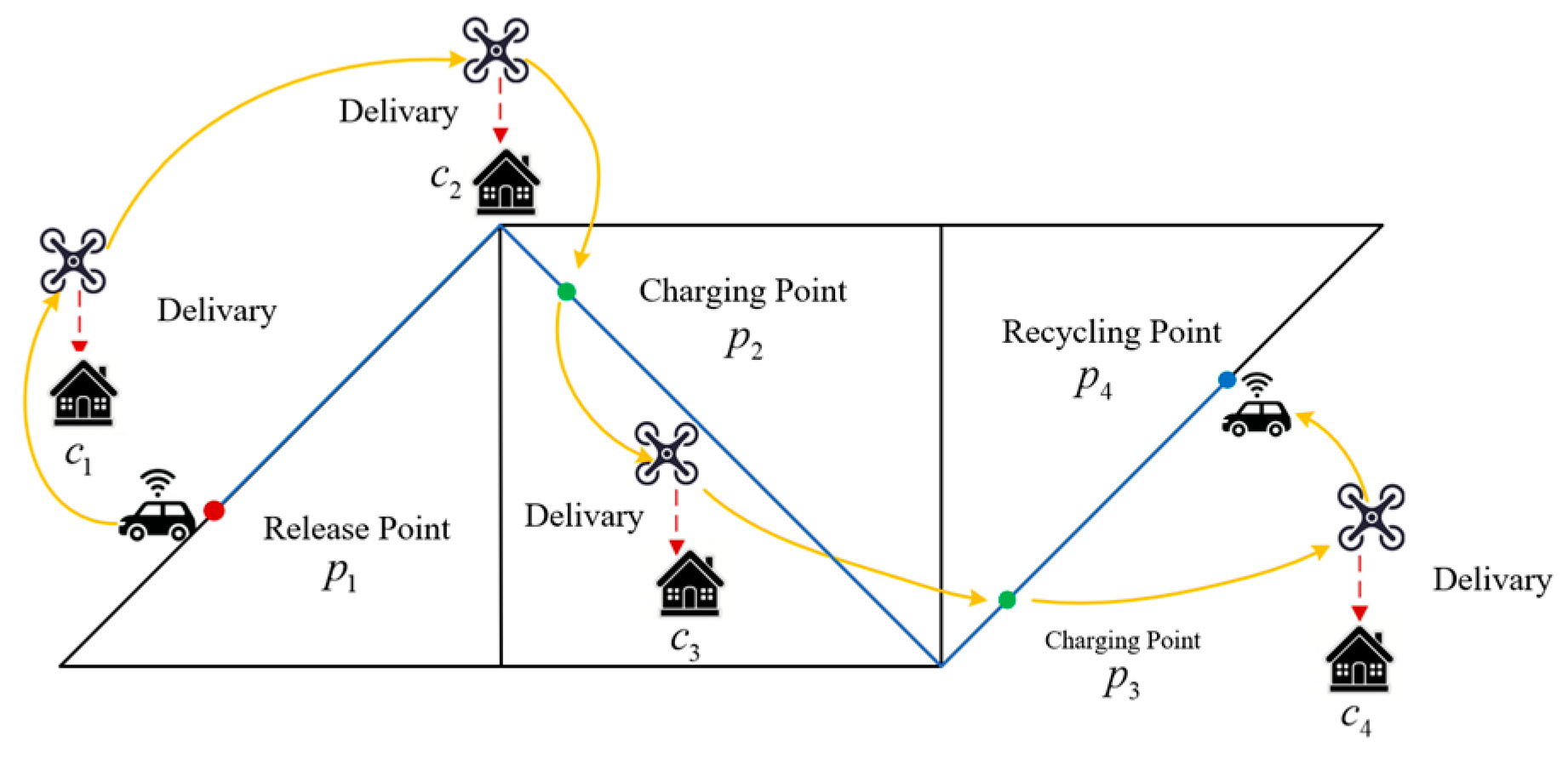
Figure 1 illustrates the collaborative delivery process for four tasks ( c 1 ,   c 2 ,   c 3   ,   c 4 ) within a representative service area. The blue arrows depict the UGV’s road-constrained trajectory, while the orange arrows trace the UAV’s flight path. The launch point p 1 (red node) initiates the UAV’s mission. The intermediate charging points p 2 and p 3 (green nodes) enable energy replenishment, and the recovery point p 4 (blue node) terminates the operation. The workflow proceeds as follows:
(1)
The UGV deploys the UAV at p 1 .
(2)
The UAV sequentially services c 1 and c 2 , and then it synchronizes with the UGV at charging point p 2 .
(3)
Post-charging, the UAV delivers to c 3 , recharges at charging point p 3 , and completes the c 4 delivery.
(4)
The UAV is ultimately retrieved via the UGV at the recovery point p 4 .

3.2. Heterogeneous System Routing Model

3.2.1. UAV Route Planning Model Under Energy Consumption Constraints

Traditional UAV energy models exclusively consider linear energy consumption associated with flight distance. However, multi-task continuous delivery necessitates a dynamic quantification of energy consumption within charging cycles. This model introduces the delivery decision variable α i j (Equation (4)) and the charging decision variable β i j (Equation (5)), decoupling energy consumption calculations for direct delivery and detour-based charging:
e t + 1 = e t c j C t t + 1 α i j R d i t j v a + β i j R d i p + d p j v a ,
where e t denotes the residual energy (J) of the UAV at time t , c i denotes the UAV’s current position (departure node) at time t , and c j denotes the target position at time t + 1 . The set C t t + 1 comprises the actual tasks performed via the UAV between t and t + 1 , thereby avoiding the exhaustive traversal of all c i and c j . Here, α i j , β i j 0 , 1 indicate the decision variables for direct flight from c i to c j or detour-based charging, respectively. The terms d i j , d i p , and d p j represent Euclidean distances (km) between tasks, from tasks to charging points, and from charging points to subsequent tasks. R denotes drone power (W), and v a denotes the UAV’s cruising speed (km/h).
According to Dorling et al. [51], the UAV power calculation formula is as follows:
R = n R = ( w + m ) 3 / 2 g 3 2 ρ ς n ,
where n denotes the number of rotors, ρ denotes the air density (kg/m3), ς denotes the disk area of a single rotor (m2), w denotes the UAV’s body weight (kg), g denotes the gravitational acceleration (m/s2), and m denotes the payload weight (kg).
The service sequence C k C defines the set of tasks served via the UAV between the k -th and k + 1 -th charging cycles. The total flight distance, d k , k + 1 , comprises three components:
(1)
Inter-task distances within C k .
(2)
Distances from tasks to intermediate charging points.
(3)
Distances from charging points to subsequent tasks.
This relationship is formalized as follows:
d k , k + 1 = c i C k c j C k α i j d i j + c i C k c j C k β i j ( d i p + d p j ) ,
where d i j denotes the Euclidean distance between tasks c i and c j . d i p and d p j denote the distances from task c i to charging point p and from p to task c j . α i j denotes the Delivery decision variable. β i j denotes the charging decision variable.
The decision variables are defined as follows:
α i j = 1 ,   if   j   immediately   follows   i   in   UAV s   path 0 ,                                   otherwise   c i C , c j { C : j i } ,
β i j = 1 ,   if   UAV   charges   at   a   Charging   Point                                             between   i   and   j 0 ,                                               otherwise c i C , c j { C : j i } .
The routing logic is constrained due to the following:
i C α i j + i C β i j = 1 ,   c j C ,
This ensures that each task, c j , is either directly serviced after c i   ( α i j = 1 ) or accessed via an intermediate charging operation ( β i j = 1 ) .

3.2.2. UGV Route Planning Model Under Road Network Constraints

In the heterogeneous cooperative delivery system, the path planning of UAVs needs to consider road network constraints. In this paper, we define the path planning objective of the UAV as minimizing the total travel time, we denote the shortest path between the k 1 -th and k -th charging points as Γ ( k ) , and we denote the shortest path distance from the k 1 -th to the k -th charging point as L ( Γ ( k ) ) .
The indicated variables for unmanned vehicle travel are as follows:
χ i j = 1 ,   if   the   UGV   selects   the   road   segment                                       from   node   i   to   j 0 ,   otherwise i ,   j V k   ,   j i .
To ensure route continuity and validity, the following flow conservation constraints are imposed:
v j V k χ i j v j V k χ j i = 1 ,   if   i = k + 1 1 ,         otherwise .
Remark 1.
For the Launch Point ( k -th Charging Point), the net outflow is 1. For the Recovery Point ( k + 1 -th Charging Point), the net inflow is 1. Intermediate nodes maintain a flow balance: inflow equals outflow.

3.2.3. Objective Function and Constraints

Based on Equations (2) and (6), the objective function of this paper is given as follows:
F = k = 2 K max ( d k 1 , k   v a , L ( Γ ( k ) ) v g )
s.t.
e t   e s a f e   , t ,
d k , k + 1   v a = L ( Γ ( k ) ) v g , k { 1 , 2 ,     ,   m } .
The objective function (Equation (9)) aims to minimize the total delivery time, where there are K charging points, v a denotes the UAV’s speed, and v g denotes the UGV’s speed. e s a f e denotes the safety energy threshold (J), and e t denotes the UAV’s energy at time t . This constraint ensures that the residual energy of the UAV at any time is not less than its safe energy threshold. Equation (11) represents an ideal equality constraint, requiring that the time taken for the UAV and the UGV to travel from the previous charging point to the next charging point be equal. This constraint avoids waiting times between the two at charging points and can be appropriately relaxed during solution iterations.
Remark 2.
This optimization problem constitutes a Bilevel-MILP problem involving two interdependent decision layers. Specifically, when planning its visiting sequence and selecting charging points, the UAV must consider not only its own energy constraints but also the UGV’s travel distance to those charging points. Similarly, the UGV’s route planning and charging point selection must adhere to road network restrictions while coordinating with the UAV’s charging needs. This interdependency and multi-objective optimization create significant complexity and challenges in solving the problem.

4. CDPO Algorithm Design

Aiming at the core challenge of the two-layer optimization mixed-integer programming problem in UAV and UAV cooperative path planning, the CDPO algorithm proposed in this paper achieves an efficient solution through a hierarchical cooperative mechanism and a directed optimization strategy. In the UAV path planning layer, ISSA initializes the population to ensure the diversity of the solution space through the roulette selection method and combines the aggregation behavior mechanism to achieve the balance between local fine search and global exploration, and its directed initialization characteristic effectively circumvents the stochastic defects of traditional algorithms in the combined explosion problem of the delivery sequences. In the charging decision optimization layer, HGA adopts the crossover mechanism to integrate the individual historical optimal and group global optimal information, retaining the local optimization features through cognitive crossover and absorbing the global mode through social crossover, while its dynamic adaptability validation and elite retention strategy ensures spatial and temporal feasibility of charging decision and energy security. The two-layer architecture forms a closed-loop feedback through nested iterations: the delivery path output from ISSA drives HGA to generate dynamic candidate charging point sets, while the charging time cost feedback from HGA inversely guides ISSA to optimize the paths. This synergistic mechanism essentially decomposes the non-convex two-layer optimization problem into two sub-problems with a Markovian nature, thus realizing the Pareto optimization of the total delivery time with the energy constraints and network constraints. Concerning the Pareto optimization of delivery times, experiments show that only the directional initialization and aggregation behavior of ISSA can effectively deal with the high-dimensional discretization of delivery paths, while the bimodal crossover and dynamic validation mechanism of HGA is the key to solving the spatial-temporal coupling of charging decisions, and the traditional single-layer or step-by-step optimization algorithms are unable to deal with the interdependence of the decisions at the two levels in a synchronized way, which inevitably leads to the degradation of the quality of the solution or the violation of the constraints.

4.1. Delivery Sequence Design Based on Improved Sparrow Search Algorithm

The Sparrow Search Algorithm (SSA) is a metaheuristic optimization method inspired by the foraging and predator-avoidance behaviors of sparrow populations. By simulating sparrows’ search for optimal positions in the solution space, it leverages diverse search strategies among individuals to exhibit strong global search capabilities. SSA efficiently explores the solution space and identifies global optima for complex optimization problems, particularly in route optimization.
To further enhance solving efficiency, the Improved ISSA proposed in this paper optimizes the traditional SSA with the following improvements:
(1)
Roulette wheel initialization: Instead of random initialization, a roulette wheel selection strategy based on the inverse of distance weighting is adopted to generate the initial population. Compared with random initialization, this strategy produces task sequences with shorter expected inter-task distances, providing ISSA with higher-quality initial solutions.
(2)
Sparrow aggregation behavior introduces sparrow flocking behavior, enabling individuals to concentrate searches near local optima and accelerating convergence while avoiding local optima traps.
These improvements allow the ISSA to rapidly converge to a high-quality task delivery sequence, providing a rational input for subsequent charging decision optimization.

4.1.1. Roulette Wheel Selection

To enhance the quality of the initial population and overcome the limitations of simple random initialization, a roulette selection strategy based on the inverse of distance weighting was adopted in ISSA to generate the initial delivery sequence.
Let the current task be denoted as i , and let u represent the set of unvisited tasks. The probability of selecting task j u as the next task is defined as follows:
p i j = d i j 1 k u d i k 1 ,
where d i j denotes the Euclidean distance between task i and task j . According to this formulation, tasks located closer to the current position are assigned higher selection probabilities, while all unvisited tasks retain non-zero probabilities, ensuring sufficient stochasticity.
During the initialization process, the first task for each individual will be randomly selected to maintain the diversity of the population. Subsequently, the remaining tasks will be selected one by one, according to the aforementioned probability distribution through the roulette wheel mechanism. This process will continue until a complete delivery sequence is generated.
The roulette wheel selection is an initialization method inspired by natural random selection processes. Its steps are detailed in Algorithm 1, and the pseudocode for the roulette wheel selection is as follows:
Algorithm 1. Roulette wheel selection.
Input: Task set C , Population size N , Number of tasks M .
Output :   Population   p o p .
1.   Create   an   empty   population   matrix   p o p .
2.  Set all points as unvisited.
3.   for   i = 1 to N do
4.      Randomly choose the first task and mark it as visited.
5.       for   j = 2 to M do
6.              Calculate the distance from the current point to all unvisited points.
7.              Compute the inverse of the distance for each point and normalize.
8.              Use cumulative probabilities to select the next point based on a random
                  number.
9.      end for
10. end for
11. return   p o p

4.1.2. Sparrow Aggregation Behavior

In nature, sparrows exhibit spontaneous aggregation behavior when threatened. After a scout detects a predator and moves, other sparrows mimic its behavior and cluster toward safer positions near the group’s center. Inspired by this behavior, the algorithm introduces sparrow aggregation after updating the scout’s position.
The aggregation behavior accelerates the population’s convergence toward the optimal solution while fine-tuning the best solutions to preserve diversity, thereby preventing premature convergence to local optima and enhancing the likelihood of finding the global optimum.
Similar to the strategy of updating the location of the scout, sparrow aggregation occurs with 10–20% of individual sparrows in the population as a whole, with the difference that aggregation is represented in this paper as a direct exchange of tasks in the delivery path. The adjustment of the aggregation behavior to the path is shown in the following equation:
S a t + 1 = arg min S { S new , S a t } F ( S )   = S new ,       if   F ( S new ) < F ( S a t ) S a t ,             otherwise ,
where S is used to denote the task delivery path, S a t denotes the task delivery path of individual a in the population at moment t , and F ( S ) denotes the current task delivery path in the objective function (Equation (9)). S n e w is the new path generated after the exchange, defined as follows:
S new = ( S a t [ c s , c s + 1 , , c s + l ] ) [ c s , c s + 1 , , c s + l ] ,
where s ~ U { 1 , M } is the randomized starting position, and S new = ( S a t [ c s , c s + 1 , , c s + l ] ) [ c s , c s + 1 , , c s + l ] [ c s , , c s + l ] S a t ,   [ c s , , c s + l ] S best means that the random variable obeys s discrete uniform distribution from 1 to M . The length of the exchange is given in Equation l = r ( M s + 1 ) , where r ( 0 , 1 ) . and denote the difference and concatenation operations of the sequence, respectively, to ensure task uniqueness. The subsequence selection rules are as follows:
[ c s , , c s + l ] S a t ,   [ c s , , c s + l ] S best ,
where [ c s , , c s + l ] S a t and [ c s , , c s + l ] S best denote consecutive subsequences starting at position s in the current path S a t and the optimal path S b e s t of the objective function value, respectively.
The steps of ISSA are detailed in Algorithm 2, and the pseudo-code is as follows:
Algorithm 2. Improved sparrow search algorithm (ISSA).
Input: Task set C , Population size N , Number of tasks M .
Output :   Best   docking   choice   time   t b e s t .
1.  Initialize population X   with   N × M   matrix   ( sparrow   positions ) ,   i t 1 = 1 ,   i t e r 1 max .
2.  Calculate initial fitness for each sparrow:
3.   f i t n e s s ( i ) = c a l c u l a t e F i t n e s s ( X [ i , : ] )
4.  Divide the population into producers and scroungers based on fitness.
5.   for   i t 1 = 1   to   i t e r 1 max do
6.      Producers’ position update:
7.       for   i = 1   to   P D N   do   ( P D indicates the proportion of producers)
8.                 x i i t 1 + 1 = x i i t 1 e i α i t e r 1 m a x if   R < S T x i i t 1 + Q L if   R S T  
9.                Where R is a random number, Q follows a normal distribution,
10.                 L   is   a   1 × M matrix with each element equal to 1.
11.      end for
12.      Scroungers’ position update:
13.       for   i = P D N + 1 to N do
14.                 x i i t 1 + 1 = Q e G worst x i i t 1 i 2 if   i > n 2 S best + | x i i t 1 S best | A + otherwise
15.                 Where   S b e s t   is   the   best   producer s   position ,   G w o r s t is the worst fitness
                     position,
16.                 A + is a matrix generated randomly.
17.      end for
18.      Scouts’ position update:
19.       Randomly   select   10 % 20 % of the population as scouts. For each scout i :
20.       x i i t 1 + 1 = G best + η | x i i t 1 G best | if   f ( x i i t 1 ) > f ( G best ) x i i t 1 + K ( | x i i t 1 G worst | + σ ) if   f ( x i i t 1 ) f ( G best ) .
21.      Where η and K are random numbers, σ is a small constant.
22.      Sparrow aggregation behavior:
23.       S a t + 1 = S a t [ r δ ( S a t   , S b e s t   ) ]
24.      Update fitness values for all sparrows.
25.       If   stopping   condition   is   met   ( e . g . ,   i t 1 = i t e r 1 m a x ), exit the loop.
26.  end for
27.   return   t best

4.2. Charging Design Optimization Based on Hybrid Genetic Algorithm

In the heterogeneous collaborative delivery system, after completing delivery tasks during a task, the UAV must decide whether to recharge based on remaining battery and route planning to maximize delivery efficiency. By introducing the charging decision variable β , this paper uniformly models the UAV’s decision-making on each route segment to minimize the total delivery time.

4.2.1. Reformulated Objective Function

Based on Equation (10), the objective function is reformulated with the delivery sequence S and charging decision β as variables:
F ( S , β ) = k = 2 K max T UAV ( k ) ( S , β ) , T UGV ( k ) ( S ) ,
where T UAV ( k ) ( β ) denotes the UAV delivery time during the k -th charging interval, determined by α and β . T UAV ( k ) denotes the UGV travel time during the k -th charging interval.
UAV delivery time:
T U A V ( k ) ( S , β )   = S ( i ) S ( k 1 k ) α S ( i ) S ( i + 1 ) d S ( i ) , S ( i + 1 ) v a + β S ( i ) d S ( i ) , k + d k , S ( i + 1 ) v a .
UGV travel time (driven by the encoded sequence S ):
T U G V ( k ) ( S ) = L ( Γ ( S , k ) ) v g     ,
where Γ ( S , k ) denotes the routing node sequence generated via the charging decisions from the k 1 -th to k -th interval in sequence S , and L ( ) computes the shortest path under road network constraints.

4.2.2. Charging Decision Optimization

The Hybrid Genetic Algorithm optimizes charging decisions by integrating population evolution mechanisms from genetic algorithms with social learning strategies from particle swarm optimization, forming a new framework. As shown in Algorithm 3, the algorithm embeds guidance mechanisms of the individual historical optimum, p b e s t , and the global population optimum, G b e s t , into the selection, crossover, and mutation operations of traditional genetic algorithms. Its core innovations include the following.
Step 1. Crossover Principle
During the crossover phase, each individual undergoes two crossover processes: (1) cognitive crossover with its historical optimal solution p b e s t to preserve locally optimized features from evolutionary history; and (2) social crossover with the global optimal solution G b e s t to assimilate optimal patterns discovered by the population. This crossover strategy simulates individual and social learning behaviors in the Particle Swarm Algorithm (PSO), balancing local refinement and global directional guidance.
Step 2. Dynamic Fitness Verification
Offspring generated from each crossover must undergo mandatory validity checks against their parents. If offspring fitness surpasses parental fitness, the offspring replace the parents in the population; otherwise, the parents are retained. This mechanism is implemented via Equation (19), where f ( x n e w   ) denotes the offspring’s fitness:
x i   = x n e w ,   if   f ( x n e w   ) < f ( x i   )   x i ,           otherwise     .
Step 3. Elitism Preservation Strategy
The global optimal solution is continuously tracked during iterations and serves as a fixed template for social crossover. This prevents a random loss of high-quality gene segments in traditional GA, ensuring convergence to the Pareto frontier.
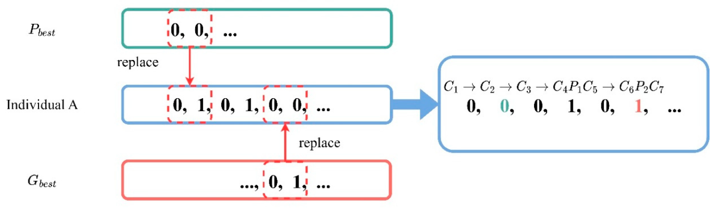
Figure 2 illustrates the crossover mechanism: When individual A crosses with p b e s t , it absorbs local optimization features (e.g., sequential delivery decisions for task cluster C 1 C 3 ); crossing with G b e s t introduces global charging point layout patterns (e.g., position selection for charging point P 2 ). This synergy enables deep local exploitation while rapidly converging to global optima, achieving optimal balance between exploration and exploitation.
Algorithm 3. Hybrid Genetic Algorithm (HGA).
Input :   Population   p o p , Task set C
Output :   Best   docking   choice   time   t b e s t .
1.   Initialize   p o p with binary values.
2.  Calculate initial fitness for each individual.
3.   Initialize   Individual   best   p b e s t ,   Global   best   G b e s t .
4.   for   i t 2 = 1   to   i t e r 2 m a x do
5.      for each individual i in population do
6.                Perform crossover:
7.                 p o p ( i , : ) = crossover ( pop ( i , : ) , P best ( i , : ) )
8.                Calculate new fitness.
9.                 if   f i t n e s s ( i ) > f i t n e s s ( P b e s t   ( i , : ) ) then
10.                         P best ( i , : ) = pop ( i , : )  
11.               end if
12.                Perform   crossover   with   G b e s t :
13.               Perform mutation by swapping two positions:
14.                m u t a t e ( p o p ( i , : ) )
15.    end for
16.     Update   G b e s t .
17.  end for
18.   return   t b e s t
The hybrid strategy proposed in this paper overcomes traditional algorithmic performance bottlenecks:
(1)
Cognitive crossover enhances local optimization capabilities under complex constraints by preserving historically optimal features of individuals;
(2)
Social crossover accelerates global convergence through swarm intelligence, effectively avoiding local optima entrapment;
(3)
The dynamic verification mechanism creates evolutionary pressure to ensure continuous improvement in population quality.
In the HGA algorithm proposed in this paper, the cognitive crossover and social crossover mechanisms are inspired by the PSO and the individual learning and social learning principles in related intelligent algorithms. The cognitive crossover emphasizes the utilization of the individual’s historical optimal solution, while the social crossover guides the group to move towards regions with global potential. Therefore, the relative influence of these two operations is designed to balance local refinement and global exploration, rather than pursuing the optimal weights for a specific problem. This paper determines the crossover weights through a preliminary calibration process based on small-scale trial runs, thereby achieving stable convergence behavior under different task densities and network sizes. The algorithm proposed in this paper does not solely favor cognitive learning or social learning; instead, it adopts moderate and balanced weights, which can avoid premature convergence due to excessive social guidance or slow convergence due to excessive individual learning. Additionally, the dynamic adaptive fitness verification mechanism and elite retention strategy in the HGA algorithm proposed in this paper can continuously eliminate infeasible or inferior offspring individuals, thereby reducing the algorithm’s sensitivity to moderate changes in parameters. Therefore, the selected crossover weights are considered to be sufficiently robust for the unmanned aerial vehicle–unmanned ground vehicle collaborative delivery problem.

4.2.3. Mathematical Modeling and Optimization of Charging Location

This paper proposes a multi-objective charging point positioning method based on dynamic candidate sets, integrating road network topology analysis and energy constraints into a discrete optimization model. The implementation workflow is as follows:
Step1. Candidate charging point generation. A road network discretization strategy generates candidate charging points P through equidistant sampling along UGV routes (Equation (19)):
P = { p m   p m   = v i   + λ ( v j   v i   ) } λ = m M   ,   m { 0 , 1 , , M }   ,
where v i , v j denotes the adjacent road network nodes, and M denotes the discretization density parameter. This ensures a comprehensive coverage of potential rendezvous paths while avoiding dimensional explosion.
Step2. Calculate the spatiotemporal synergy. For the candidate point p m P , the following operation is performed: calculate the UAV drop time T U A V ( k ) ( S , β ) from the previous charging point p k 1 to p m according to Equation (16), and then calculate the UGV travel time T U G V ( k ) ( S ) from the previous charging point p k 1 to p m according to Equation (17).
Step3. Iterate through all the candidate points p m P , and select the candidate point that minimizes max ( T U A V ( k ) ( S , β ) , T U G V ( k ) ( S ) ) as the k -th charging point p k . Also, verify the feasibility of the energy constraint Equation (10), and if the energy e t remaining after traveling to a candidate point p m does not satisfy e t   e s a f e , the point is eliminated from the candidate set.

4.3. Collaborative Mechanism of the Bilevel Optimization Framework

The CDPO algorithm adopts a nested ISSA-HGA architecture to achieve a dynamic balance between global and local optimization. Mathematically, this can be expressed as follows:
min S S n min β { 0 , 1 } n F n e w ( S , β ) ,
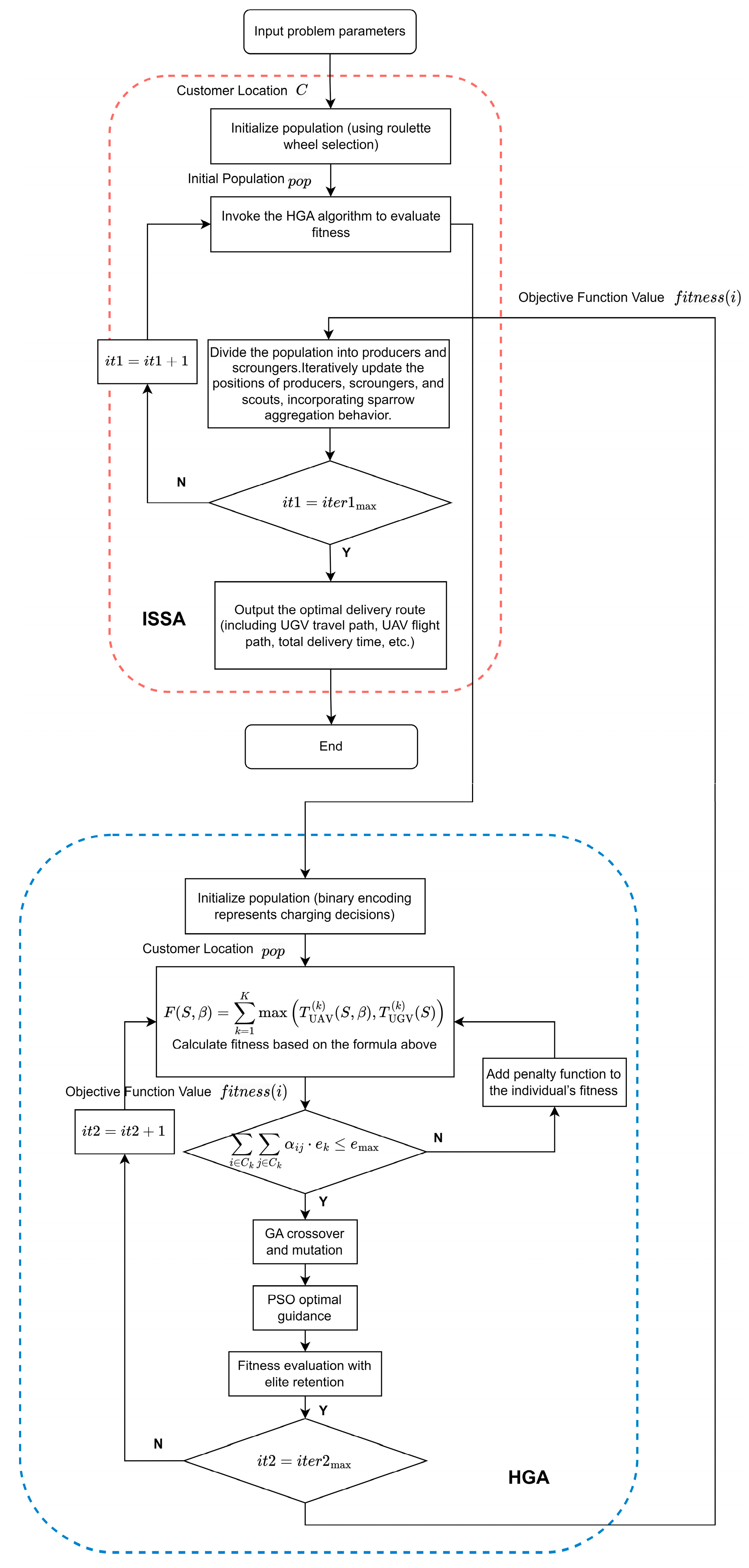
where S n represents the set of permutations for n tasks. The implementation workflow is illustrated in Figure 3. Under the assumption that the ISSA algorithm iterates for i t e r 1 max generations and the HGA algorithm iterates for i t e r 2 max generations, the flowchart explicitly demonstrates the nested collaborative process between ISSA and HGA. ISSA first optimizes the UAV delivery sequence, then HGA solves for the optimal charging strategy based on this sequence and returns the total delivery time. Through this bilevel optimization, the global optimal solution is ultimately achieved, enhancing delivery efficiency while ensuring that the system satisfies energy and road network constraints to attain the shortest total delivery time.

5. Simulation

5.1. Experimental Setup

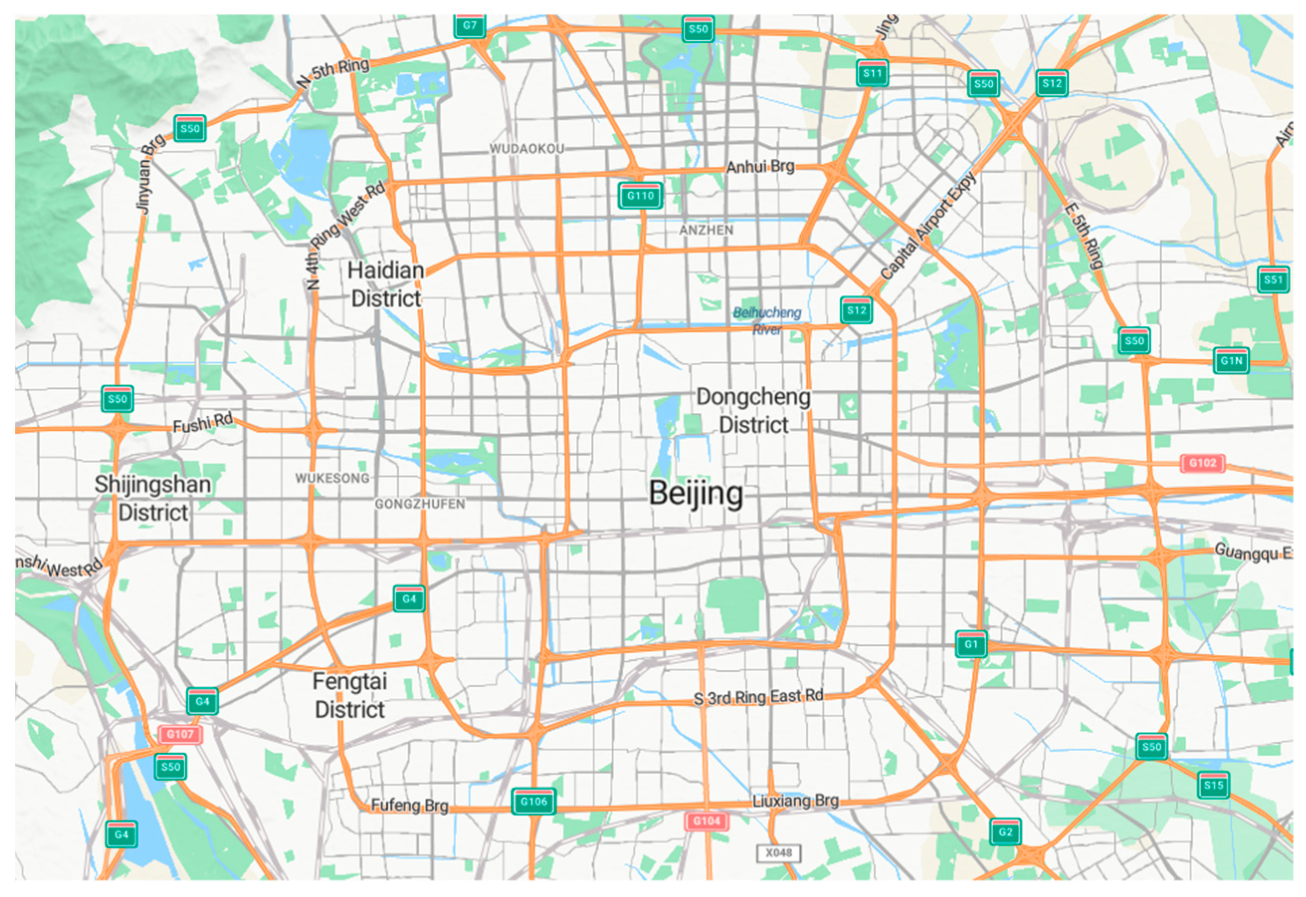
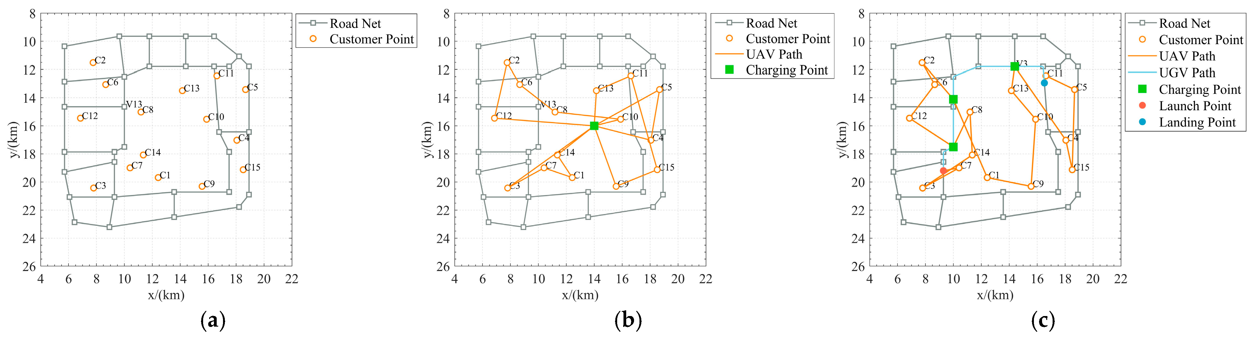
This paper constructs a simulation environment based on the arterial road network within Beijing’s Third Ring Road (see Figure 4). Three scenarios with distinct road network densities and task distribution characteristics are employed: small-scale (5 km × 5 km, 10 tasks), medium-scale (7 km × 7 km, 15 tasks), and large-scale (10 km × 10 km, 20 tasks). Each road segment is discretized into 10 candidate charging points, resulting in a total of candidate points. This design validates algorithmic robustness across spatial scales and task complexities: small-scale scenarios focus on foundational verification, medium-scale scenarios simulate typical urban delivery demands, and large-scale scenarios stress-test algorithm performance under extreme conditions.
The UAV speed is set to 54 km/h and the UGV cruising speed to 18 km/h [22]. Key parameters include six rotors (n), air density ρ = 1.204 kg/m3, single rotor disk area ς = 0.2 m2, UAV body weight w = 1.5 kg, gravitational acceleration g = 9.8 m/s2 [52], and payload weight m = 2 kg. The resultant total power R is 118.5 W. With a maximum safe flight duration of 30 min, the theoretical energy consumption is approximately 213,300 J. Assuming a battery capacity of 10,000 mAh and a rated voltage of 11.1 V (total energy: 399,600 J), the safety energy threshold e s a f e is set to 186,300 J.
The hardware platform utilizes an Intel Core i9-9900 KF3.60GHz processor, 16 GB of RAM, an NVIDIA GeForce RTX 2080 SUPER graphics card, a Windows 10 x64 operating system, and the MATLAB 2021a simulation software. The experimental design adopts a hierarchical validation paradigm: Experiment 1 decouples the bilevel optimization structure to independently evaluate each layer’s performance, while Experiment 2 conducts full-system integration to assess collaborative optimization efficacy.

5.2. Experiment 1: Hierarchical Algorithm Comparisons

This experiment validated the independent effectiveness of each layer in the CDPO framework. To control variable interference, one layer was fixed to a baseline method while comparing different algorithms for the other layer. The compared algorithms were configured as follows:

5.2.1. First-Layer Algorithm Performance

The Ant Colony Algorithm, the Particle Swarm Algorithm, and the Sparrow Search Algorithm are selected as comparison algorithms for the first layer of algorithms; these algorithms, as well as ISSA algorithms, exhibit high population intelligence optimization characteristics and combinatorial optimization capabilities, which are suitable for solving delivery paths. In which the pheromone importance factor of ACO algorithm was set to 10, the importance factor of heuristic function was set to 2, the pheromone volatility coefficient was set to 0.5, the inertia weights of PSO algorithm were set to 0.7, the individual learning factor was set to 1.5, the group learning factor was set to 1.8, the SSA algorithm’s Discoverer Proportion set to 0.2 with the Vigilant Proportion set to 0.1, and the Safety Value was set to 0.6. The other parameter settings of the ISSA algorithm are the same as those of the SSA algorithm, and the Aggregation Behavior Proportion is set to 20%.
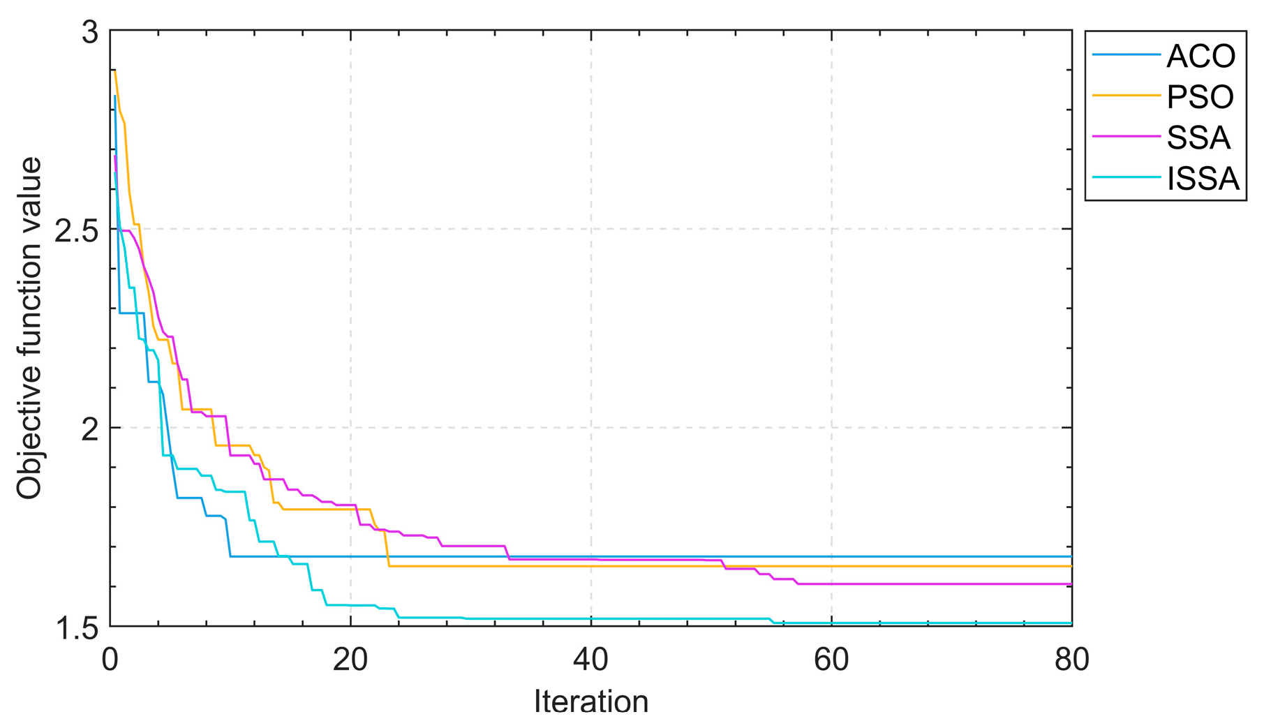
Figure 5 shows that the ISSA algorithm exhibits significant advantages in medium-sized scenarios. Its initial solution quality (1.8790 h at 20 iterations) is improved by 8.2% compared to the SSA algorithm (2.0458 h); this improvement is mainly attributed to the roulette wheel initialization strategy, which generates higher-quality initial solutions than random initialization by probabilistically favoring shorter inter-task distances. When iterating 80 times, the ISSA algorithm converges to 1.5192 h, which is 10.7% optimized compared to the SSA algorithm (1.7018 h), proving that the sparrow aggregation behavior effectively avoids precocious convergence through the local perturbation mechanism. On the contrary, the ACO algorithm and PSO algorithm, due to the inherent defects of pheromone positive feedback and particle speed inertia, fall into the local optimum after 60 iterations (1.6754 h vs. 1.6511 h), and they are unable to break through the local optimum trap of path order.

5.2.2. Second-Layer Algorithm Performance

Differential evolutionary algorithms (DEs), evolutionary strategies (ESs), and genetic algorithms (GAs) are selected as comparison algorithms for the second layer of algorithms, and the core strength of these algorithms, as well as the HGA algorithm, lies in their coding flexibility and constraint handling ability for solving charging decisions. The scaling factor and crossover probability of DE are set to 0.5 and 0.9, respectively, the population size and variance strength of ES are set to 100 and 0.1, respectively, and the crossover probability and the probability of variance of GA are set to 0.8 and 0.01, respectively.
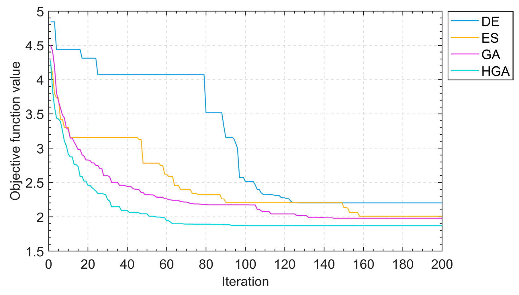
Figure 6 shows that the HGA algorithm achieves an efficient exploration of the solution space in charging decision optimization through the crossover mechanism (dynamic crossover of individual/global optimal solutions), and the mandatory validity verification ensures the legitimacy of the solution, accelerates the convergence, and ultimately achieves the global optimum in 1.8700 h, which reflects a 5.5% increase in efficiency compared to the GA algorithm. The DE algorithm and the ES algorithm lagged behind in the speed of convergence due to the lack of a guided search mechanism (2.2008 h for DE algorithm and 2.0086 h for the ES algorithm after 200 iterations). In particular, the HGA algorithm completed 90% of the optimization process by the 60th iteration (1.9419 h), indicating that its hybrid architecture can quickly target high-quality solution space regions.

5.3. Experiment 2: Comprehensive Algorithm Comparison

This experiment compares the system performance between CDPO (as a dynamic charging strategy) and the traditional fixed charging strategy (FCS). FCS employs ISSA for delivery sequence optimization while fixing charging points at the central node [25,27] of the road network, requiring drones to return to static stations for recharging. In contrast, CDPO dynamically selects optimal charging points via HGA.
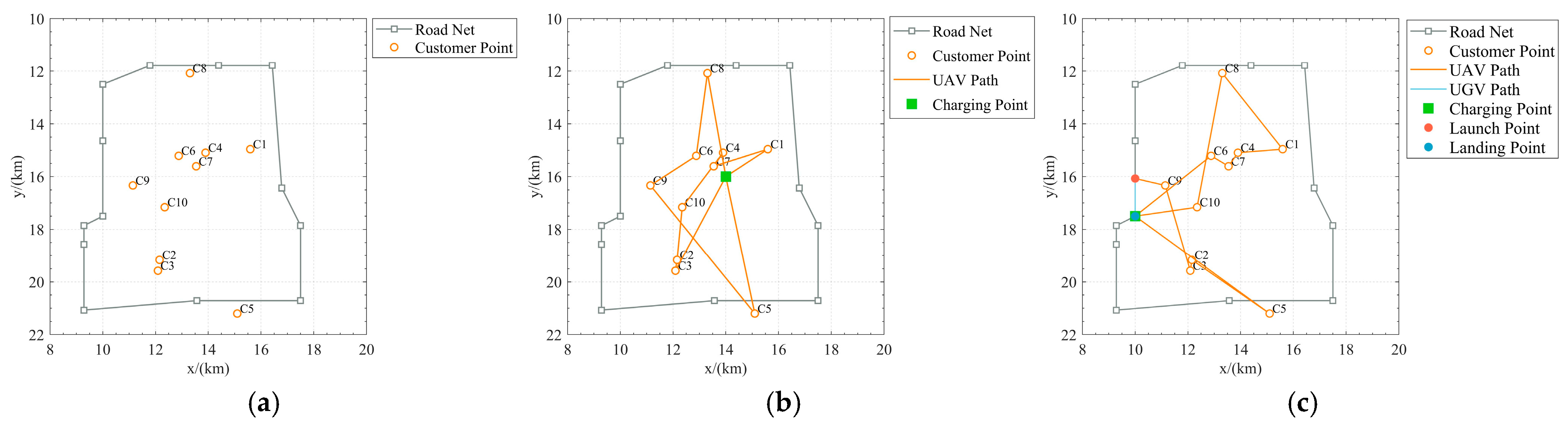
Table 1 demonstrates that, in the small-scale scenario (Figure 7), CDPO reduces the drone’s flight distance by 4.9% (34.55 km → 32.85 km) by relocating the charging point to Node 60 (a discretized road network point). Although the charging frequency remains identical (1 time), the dynamic charging point shortens the recharging route, resulting in a 4.8% reduction in the total delivery time (0.6398 h → 0.6088 h).
Table 2 reveals that, in the medium-scale scenario, CDPO strategically positions charging points (IDs 110, 9, 25) near geometric centers of clustered task groups (Figure 8), whereas FCS incurs detours due to its fixed off-center station. With an identical charging frequency (3 times), CDPO reduces the drone’s flight distance by 17.6% (73.99 km → 60.93 km) and optimizes delivery times by 21.2% (1.3702 h → 1.1284 h).
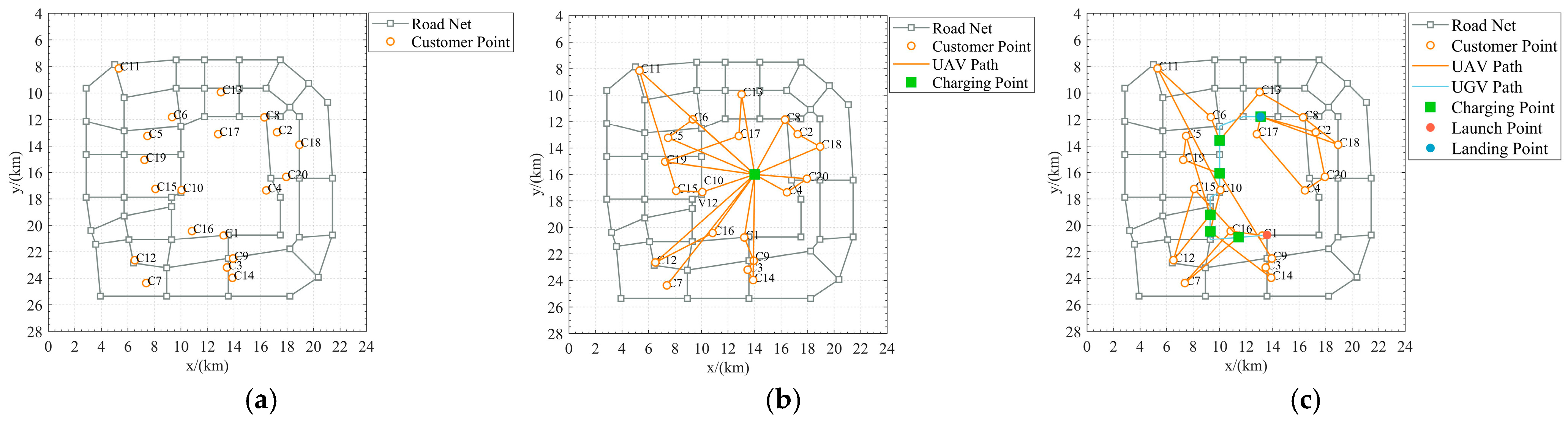
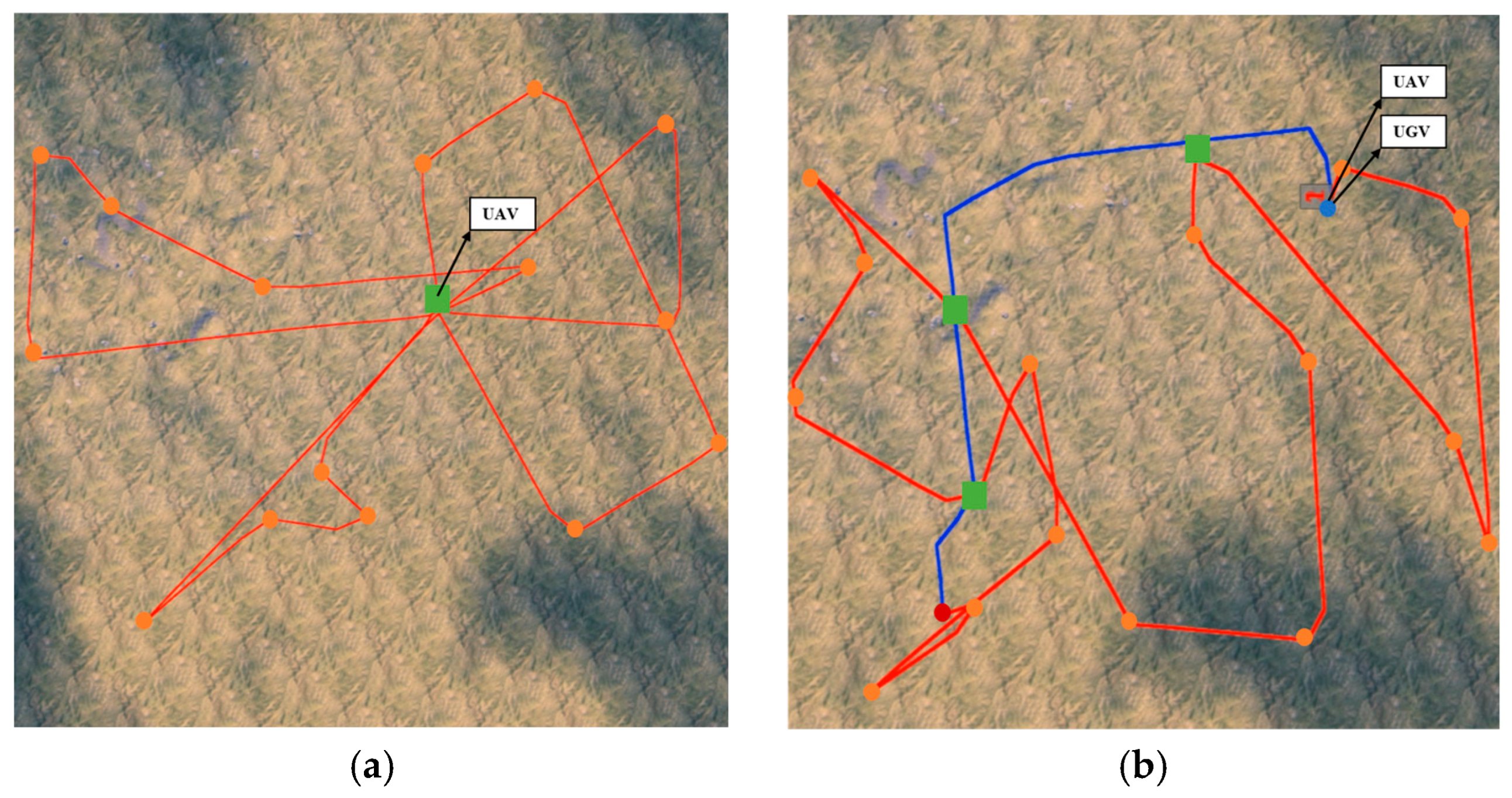
Table 3 highlights the most compelling results in the large-scale scenario: CDPO achieves a 24.3% reduction in flight distance (145.15 km→109.82 km) and a 33.9% improvement in total delivery times (2.6880 h→1.7761 h) under less charging frequency (6 times). Path comparisons (Figure 9) illustrate that FCS generates redundant radial routes (e.g., repeated segments between the center station and task 7) due to fixed charging stations, while CDPO forms continuous loops via dynamic charging point selection, minimizing inefficient flight paths.

5.4. Hardware-in-the-Loop Experiment

This section evaluates the effectiveness of the proposed CDPO algorithm in real hardware environments through hardware-in-the-loop (HIL) experiments. The HIL methodology offers the following advantages: (1) the integration of physical hardware components and sensors to simulate real-world operational conditions; (2) safe algorithm verification without risks associated with physical UAV hardware testing; (3) cost-effectiveness compared to field trials of UAV swarms while maintaining equivalent efficacy; (4) and repeatable experimental procedures. Traditional MATLAB simulations lack physical hardware interactions and fail to reveal temporal or positional discrepancies inherent to real systems due to their reliance on computational models. In contrast, HIL compensates for these limitations through real-time hardware-in-the-loop feedback, enabling a robust validation of algorithmic robustness and real-time performance in quasi-physical environments.
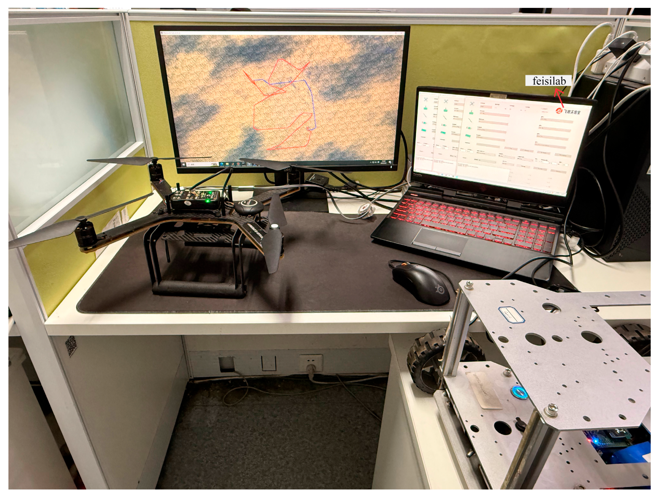
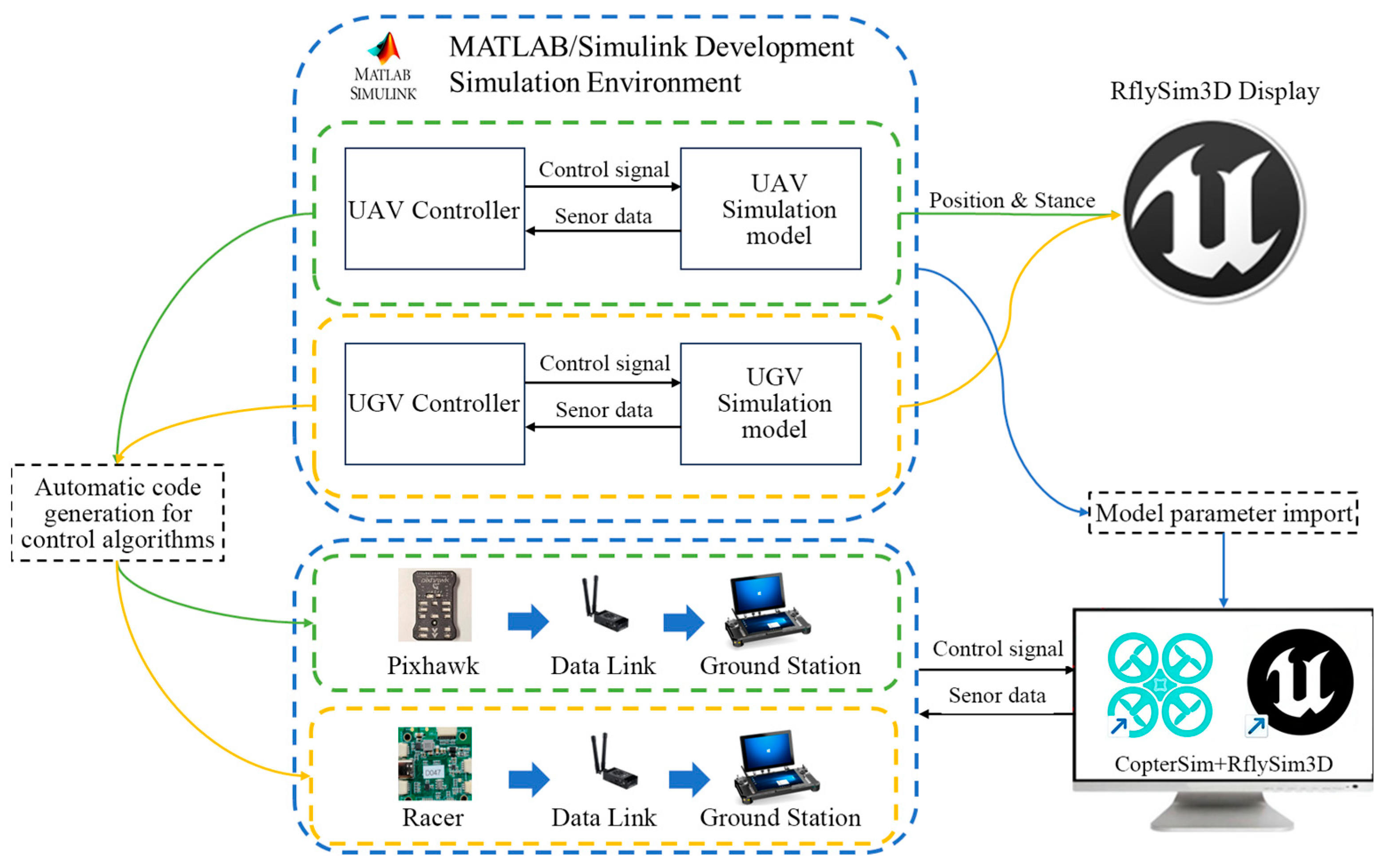
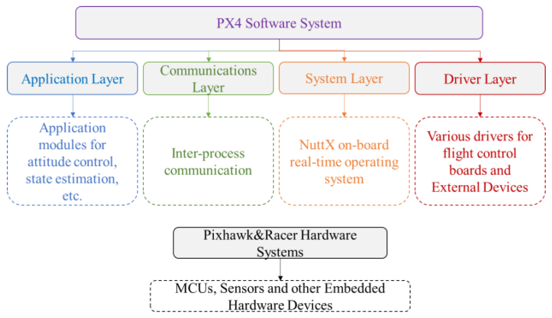
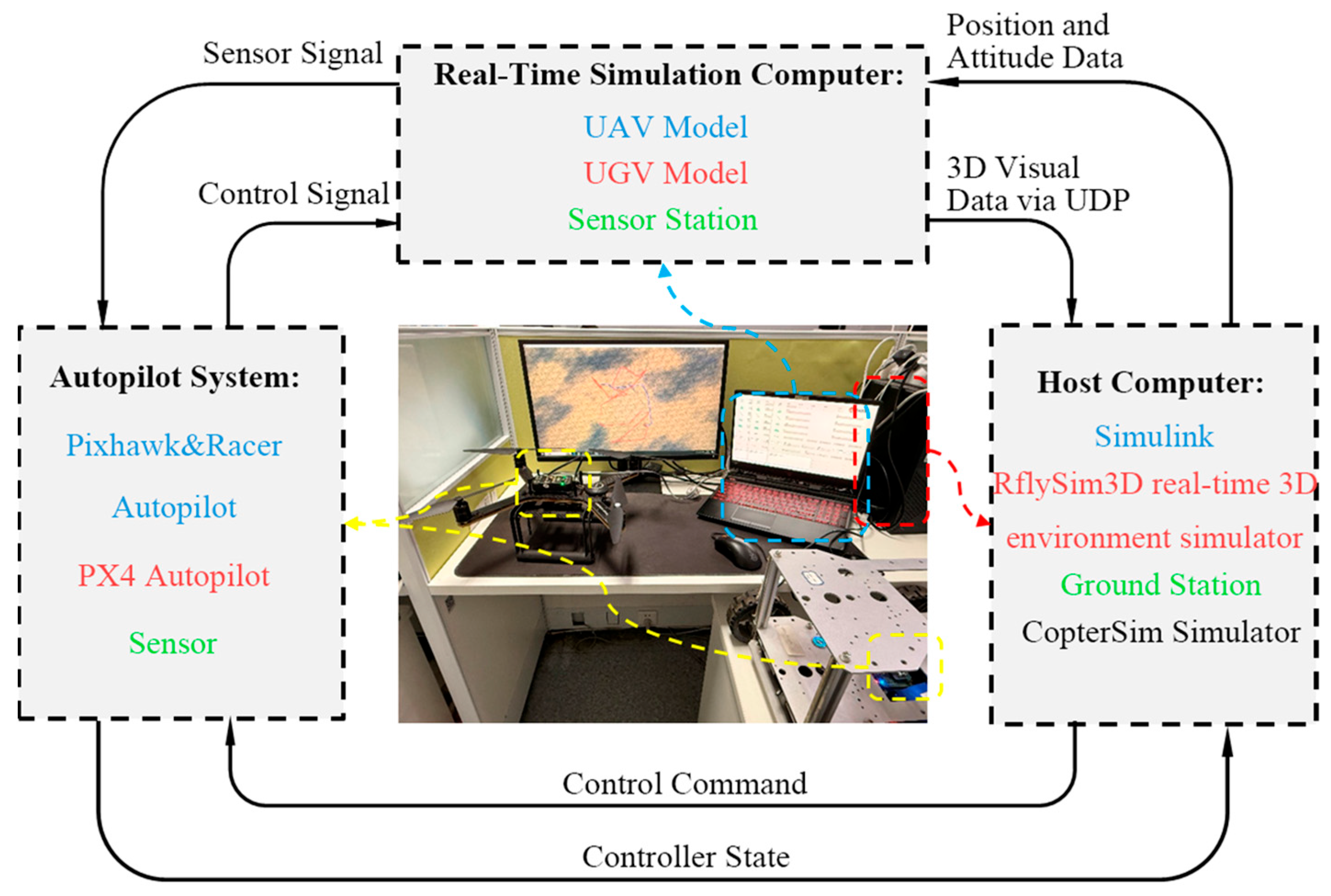
Figure 10 illustrates the comprehensive layout and connectivity of the HIL test platform, while Figure 11 details the development workflow of the UAV simulation system software based on RFlySim (v3.03). Within the cooperative autonomous driving framework, the aerial unit employs the open-source Pixhawk 2.4.8 controller (a mainstream embedded platform in small UAV domains) integrated with the PX4 flight control stack. The ground unit utilizes the Racer smart vehicle platform embedded with the homologous PX4 control framework, collectively forming an air–ground collaborative autonomous system (system hierarchy shown in Figure 12). This architecture adheres to modular hierarchical design principles: upper-layer application modules (including core algorithms such as attitude resolution and state observation) achieve distributed collaboration via middleware; the NuttX (v12.4.0) real-time kernel provides deterministic task scheduling through priority-based preemption mechanisms to ensure strict temporal constraints; the device driver layer implements physical signal encoding for actuator commands and protocol decoding for sensor data, thereby establishing a complete control loop spanning sensor data acquisition, state estimation, control computation, and actuator output.
Figure 13 presents the communication architecture of the UAV HIL simulation platform. The simulation computer establishes physical connectivity with the Pixhawk flight controller via the USB serial protocol, while the CopterSim (v3.03) software platform forms bidirectional data exchange channels with the Pixhawk/Racer-PX4 hardware system. This configuration enables the real-time transmission of control commands from the flight controller to the simulation environment, with concurrent feedback of multimodal sensor data to construct physically authentic dynamic testing scenarios. Heterogeneous systems communicate through the MAVLink v1 protocol (widely adopted in UAV–UGV air-ground communications), achieving low-latency, high-reliability data transmission. The platform innovatively integrates HIL simulation technology, precisely replicating full-dimensional UAV operational parameters and establishing an industrial-grade closed-loop verification system, thereby providing robust semi-physical validation foundations for complex control algorithm implementation.
The HIL experiments rigorously replicated the task distribution of simulation scenarios (Figure 14a,b), maintaining identical parameter configurations: a UAV speed of 54 km/h, a UGV speed of 18 km/h, and a safety energy threshold of 186,300 J. The experimental results demonstrate that CDPO achieved a total delivery time of 1.1421 h in HIL environments, showing a marginal deviation of 1.2% from MATLAB simulation results (1.1284 h). The FCS method yielded an HIL delivery time of 1.3986 h, deviating 2.1% from its simulation result (1.3702 h). CDPO’s UAV flight distance measured 62.15 km in HIL tests, exhibiting a 2.0% increase compared to simulated results (60.93), while FCS recorded a 74.82 km flight distance with a 1.1% deviation from simulation (73.99 km). These minor discrepancies primarily originate from sensor noise and communication latency inherent to HIL platforms, yet they remain within acceptable tolerances, confirming algorithmic stability in physical environments. Notably, CDPO generated identical delivery sequences [7, 3, 14, 8, 12, 6, 2, 1, 9, 10, 13, 4, 15, 5, 11] in both HIL and simulations, verifying its strong robustness in path planning.
The HIL experimental results conclusively demonstrate that CDPO reliably guides UAV–UGV systems to complete delivery tasks in physical environments, with all performance metrics showing high consistency (deviation < 2.5%) with the simulation results. This validates the effectiveness of safety trajectory strategies and dynamic charging decisions. By integrating road network discretization modeling with a bilevel cooperative optimization mechanism, CDPO successfully mitigates environmental uncertainties in hardware implementations, providing both theoretical and practical foundations for deploying urban intelligent logistics systems.

6. Discussion

Regarding the existing research on the collaborative delivery of unmanned aircraft and unmanned vehicles based on the TSP-D and CVP-D frameworks, it has been demonstrated that joint air–ground path planning is effective in shortening the delivery time and reducing operating costs (e.g., [23,25,32]). However, most of these studies rely on static or preset charging points, and the unmanned aircraft must return to fixed warehouses or truck parking points for charging operations. Therefore, this limits further performance improvement. In contrast, the CDPO framework proposed in this paper innovatively incorporates dynamic charging point selection into the network constraints, enabling the unmanned aircraft to rendezvous with the unmanned ground vehicles at optimized network nodes. The results of the simulation experiments in Section 5.3 show that CDPO can reduce the total delivery time by 33.9% in large-scale scenarios and shorten the flight distance of the unmanned aircraft by 24.3%, indicating that the design of the charging point selection strategy is particularly important in high-density unmanned aircraft–unmanned ground vehicle logistics systems.
The performance differences between the proposed method and previous methods mainly result from three key factors. Firstly, CDPO adopts a two-layer optimization structure, linking the delivery sequence of the drones with the charging decisions of the unmanned vehicles. In contrast, many existing studies consider charging points as fixed and only optimize the flight routes of the drones, which may lead to poor coordination and increased waiting or detour costs.
Secondly, the generation strategy of dynamic charging points utilizes the discretization of the road network to match the charging points with spatial task communities. This enables the drones to maintain continuous delivery cycles without repeatedly returning to the central warehouse. The results of the simulation experiments in medium and large-scale scenarios proposed using this method show that this strategy significantly reduces path redundancy and detour losses, and this effect cannot be achieved using static charging points, even when optimizing the routes.
Thirdly, the hybrid ISSA-HGA optimization architecture enhances scalability in cases of dense task distribution. The directional initialization and aggregation behavior of ISSA improve the quality of the solution at the delivery sequence level, while the cognitive-social cross and dynamic verification mechanism of HGA ensures feasible and efficient charging decisions. This hierarchical cooperation alleviates the premature convergence and performance degradation problems that commonly occur in single-layer heuristic methods as the scale of tasks increases.
Furthermore, the consistency between the simulation experiment results and the hardware-in-the-loop experiment results demonstrates that the performance advantages of CDPO can achieve robust improvements under quasi-physical execution conditions.
These findings emphasize the importance of integrating road network perception, energy dynamics, and collaborative decision-making when designing scalable and deployable unmanned aircraft–unmanned ground vehicle delivery systems suitable for urban environments.

7. Conclusions

7.1. Theoretical Contribution

This paper makes several theoretical contributions to the UAV–UGV collaborative logistics optimization literature. First, a bilevel mixed-integer linear programming (Bilevel-MILP) model was developed to explicitly integrate urban road network topology with UAV energy consumption constraints. Unlike most existing studies that focus on single-task UAV sorties or assume static charging locations, the proposed model enables multi-task continuous UAV delivery while accounting for road-constrained UGV mobility and dynamic energy depletion. This formulation extends the conventional CVP-D framework to better reflect the spatiotemporal coupling characteristics of heterogeneous delivery systems in complex urban environments.
Second, a CDPO framework is proposed to solve the resulting coupled routing and charging decision problem. By decomposing the optimization process into two interdependent layers—UAV delivery sequence optimization and UGV charging decision optimization—the framework effectively addresses the non-convexity and high-dimensionality of the problem. The simulation results demonstrate that this integrated optimization mechanism leads to substantial performance improvements, particularly under dense task distributions, validating the theoretical effectiveness of the proposed bilevel formulation. The integration of an ISSA with directional initialization and aggregation behavior, together with an HGA incorporating cognitive and social crossover mechanisms, provides a novel methodological pathway for jointly optimizing delivery sequences and dynamic charging strategies under energy and road network constraints.

7.2. Practical Contributions

From a practical perspective, the CDPO method proposed in this paper provides a reliable solution for the collaborative logistics system of unmanned aircraft and unmanned vehicles. The paper employs a dynamic charging point selection mechanism, enabling unmanned aircraft to flexibly rendezvous with unmanned vehicles at road network nodes and thereby significantly reducing unnecessary detours caused by fixed charging stations. Compared with the traditional fixed charging strategy, the proposed approach reduces the total delivery time by up to 33.9% and the UAV flight distance by up to 24.3% in large-scale scenarios, demonstrating clear operational advantages.
This feature is particularly advantageous in high-density task scenarios, where it can effectively avoid frequent returns to static warehouses, thereby reducing flight distances and delivery delays. Additionally, the paper also used a battery replacement strategy supported with a mobile unmanned vehicle platform, which can achieve almost real-time energy replenishment, thereby greatly reducing charging pause times and improving delivery continuity. The simulation results show that, compared with the traditional fixed charging strategy, the method proposed in this paper significantly reduces the total delivery time and the flight distance of unmanned aircraft in small-scale, medium-scale, and large-scale scenarios. Moreover, hardware-in-the-loop experiments show that the performance gap between simulation and physical execution remains within 2%; the effectiveness and real-time feasibility of the CDPO framework are further verified, indicating that the proposed method exhibits great deployment potential in intelligent urban logistics systems, emergency material distribution, and other time-sensitive delivery applications.

7.3. Limitations and Future Research

In addition to the aforementioned advantages, the method proposed in this paper also involves certain limitations that require further research. Firstly, this simulation framework assumes that all delivery tasks and road network information are known in advance. However, real logistics systems often involve dynamic task arrival times and uncertain traffic conditions. Secondly, the drone energy consumption model mainly considers the flight distance and the load effect, but it does not take into account external disturbances, such as wind-field disturbances and other environmental factors. Future work will incorporate time-window constraints and multi-agent collaboration mechanisms to improve service timeliness and scalability. Additionally, distributed cooperative algorithms will be explored to strengthen system robustness in complex urban settings, supporting scalable real-world deployments.


Author Contributions

Conceptualization, C.Z., Q.Y. and W.Y.; methodology, C.Z., Q.Y. and W.Y.; software, Q.Y.; validation, C.Z., Q.Y. and J.L.; formal analysis, Q.Y.; investigation, Q.Y. and J.L.; resources, C.Z. and W.Y.; data curation, C.Z., Q.Y. and N.Y.; writing—original draft preparation, Q.Y.; writing—review and editing, J.L.; visualization, C.Z., W.Y. and N.Y.; supervision, W.Y.; project administration, W.Y.; funding acquisition, C.Z. All authors have read and agreed to the published version of the manuscript.

Funding

This research was funded by the Liaoning Provincial Natural Science Foundation (General Program, 2025-MSLH-107) and the Liaoning Provincial Key Technology R&D Program (2024JH2/102600155).

Institutional Review Board Statement

Not applicable.

Informed Consent Statement

Not applicable.

Data Availability Statement

No new data were created or analyzed in this study. Data sharing does not apply to this article.

Conflicts of Interest

The authors declare no conflicts of interest.

References

  1. Macioszek, E.; Jurdana, I. Analysis of the development of e-commerce in Poland from 2010–2020 and its impact on the transport sector. Zesz. Naukowe. Transp./Politech. Śląska 2022, 116, 197–209. [Google Scholar] [CrossRef] [Scilit]
  2. Fu, H.; Cui, Y.; Zhao, J.H.; Ye, Y.; Hu, Q.; Wu, Z.X.; Huang, L.R. A Review of Research and Applications in Low-altitude Logistics and Delivery Using Unmanned Aerial Vehicles. Ind. Eng. J. 2025, 28, 9–21. [Google Scholar]
  3. Zhang, D. Optimizing Urban Logistics through Low-Altitude Aerial Routes: A Study on UAV Integration in Supply Chains. In Proceedings of the 2025 5th International Conference on Enterprise Management and Economic Development (ICEMED 2025), Dali, China, 30 May–1 June 2025; pp. 973–982. [Google Scholar]
  4. Yang, J.; Meng, Z.; Xu, X.; Chen, K.; Li, E.L.; Zhao, P.G. Task-Oriented Edge-Assisted Cooperative Data Compression, Communications and Computing for UGV-Enhanced Warehouse Logistics. In Proceedings of the 2025 IEEE 22nd Consumer Communications & Networking Conference (CCNC), Las Vegas, NV, USA, 10–13 January 2025; pp. 1–8. [Google Scholar]
  5. Moradi, N.; Sadati, I.; Çatay, B. Last mile delivery routing problem using autonomous electric vehicles. Comput. Ind. Eng. 2023, 184, 109552. [Google Scholar] [CrossRef] [Scilit]
  6. Li, B.; Liu, S.; Tang, J.; Gaudiot, J.L.; Zhang, L.; Kong, Q. Autonomous last-mile delivery vehicles in complex traffic environments. Computer 2020, 53, 26–35. [Google Scholar] [CrossRef] [Scilit]
  7. Mao, Y.; Jia, G. Research on the optimization of delivery routes for vehicles with drones under no-fly zone restrictions. PLoS ONE 2025, 20, e0335614. [Google Scholar] [CrossRef] [Scilit] [PubMed]
  8. Sidikov, R. Regulatory Challenges and Future Perspectives for Unmanned Aerial Vehicles. Uzb. J. Law Digit. Policy 2025, 3, 1–18. [Google Scholar] [CrossRef] [Scilit]
  9. Truong, D.; Lee, S.-A.; Nguyen, T. How to Enhance Safety of Small Unmanned Aircraft Systems Operations in National Airspace Systems. Drones 2024, 8, 774. [Google Scholar] [CrossRef] [Scilit]
  10. Rauhala, A.; Leviäkangas, P.; Tuomela, A. The Governance and Regulations of Unmanned Aircraft Systems in the European Union–A Comparative Framework. In Proceedings of the Transport Research Arena Conference, Dublin, Ireland, 15–18 April 2024; pp. 689–694. [Google Scholar]
  11. Anicho, O.; Atulya, N.; Bansal, J.C. Considerations for unmanned aerial system (uas) beyond visual line of sight (bvlos) operations. Drones Auton. Veh. 2024, 1, 10010. [Google Scholar] [CrossRef] [Scilit]
  12. Qi, Y.; Jiang, H.; Huang, G.; Yang, L.; Wang, F.; Xu, Y. Multi-UAV path planning considering multiple energy consumptions via an improved bee foraging learning particle swarm optimization algorithm. Sci. Rep. 2025, 15, 1–16. [Google Scholar] [CrossRef] [Scilit]
  13. Ahmed, S.; Emon, N.I. Power Consumption Analysis of UAVs with Varying Payloads for Next Generation Wireless Networks. MIST Int. J. Sci. Technol. 2025, 13, 85–95. [Google Scholar] [CrossRef] [Scilit]
  14. Zhang, Y.; Xu, W.; Ye, H.; Shi, Z. A Two-Stage Optimization Framework for UAV Fleet Sizing and Task Allocation in Emergency Logistics Using the GWO and CBBA. Drones 2025, 9, 501. [Google Scholar] [CrossRef] [Scilit]
  15. Sun, J.; Wang, W.; Li, S.; Da, Q.; Chen, L. Scheduling optimization for UAV communication coverage using virtual force-based PSO model. Digit. Commun. Netw. 2024, 10, 1103–1112. [Google Scholar] [CrossRef] [Scilit]
  16. Munasinghe, I.; Perera, A.; Deo, R.C. A Comprehensive Review of UAV-UGV Collaboration: Advancements and Challenges. J. Sens. Actuator Netw. 2024, 13, 81. [Google Scholar] [CrossRef] [Scilit]
  17. Ding, Y.; Wan, J.; Lin, W.; Wang, K. Coordinated last-mile deliveries with trucks and drones: A comparative study of operational modes. J. Air Transp. Res. Soc. 2024, 3, 100025. [Google Scholar] [CrossRef] [Scilit]
  18. Wang, Y.; Yang, S.; Wang, X.V.; Wang, L. Research on truck-drone collaborative route planning for rural logistics delivery services. Sci. Rep. 2024, 14, 31815. [Google Scholar] [CrossRef] [Scilit]
  19. Han, X.; Shen, J. Vehicle routing problem with trucks and drones collaboration: A structured literature review. Appl. Comput. Intell. 2025, 5, 348–358. [Google Scholar] [CrossRef] [Scilit]
  20. Bederina, H. Optimizing UAV Trajectories via a Simplified Close Enough TSP Approach. arXiv 2025, arXiv:2507.03775. [Google Scholar] [CrossRef] [Scilit]
  21. Zhen, Y. Research on Task Assignment and Path Planning Algorithm for Multi-UAV Collaboration. Front. Comput. Intell. Syst. 2025, 14, 55–60. [Google Scholar] [CrossRef] [Scilit]
  22. Chen, Y.; Chen, M.; Chen, Z.; Cheng, L.; Yang, Y.; Li, H. Delivery path planning of heterogeneous robot system under road network constraints. Comput. Electr. Eng. 2021, 92, 107197. [Google Scholar] [CrossRef] [Scilit]
  23. Macrina, G.; Pugliese, L.D.P.; Guerriero, F.; Laporte, G. Drone-aided routing: A literature review. Transp. Res. Part C Emerg. Technol. 2020, 120, 102762. [Google Scholar] [CrossRef] [Scilit]
  24. Vásquez, S.A.; Angulo, G.; Klapp, M.A. An exact solution method for the TSP with Drone based on decomposition. Comput. Oper. Res. 2021, 127, 105127. [Google Scholar] [CrossRef] [Scilit]
  25. AlMuhaideb, S.; Alhussan, T.; Alamri, S.; Altwaijry, Y.; Aljarbou, L.; Alrayes, H. Optimization of Truck-Drone Parcel Delivery Using Metaheuristics. Appl. Sci. 2021, 11, 6443. [Google Scholar] [CrossRef] [Scilit]
  26. Xiong, H.; Lei, D.; Li, M. Multi-objective traveling salesman problem with drone: Imperialist competitive algorithm. In Proceedings of the 2022 34th Chinese Control and Decision Conference, Hefei, China, 15–17 August 2022; pp. 3635–3640. [Google Scholar]
  27. Gonzalez-Rodríguez, P.L.; Sanchez-Wells, D.; Andrade-Pineda, J.L. A bi-criteria approach to the truck-multidrone routing problem. Expert Syst. Appl. 2024, 243, 122809. [Google Scholar] [CrossRef] [Scilit]
  28. Farrag, T.A.; Askr, H.; Elhosseini, M.A.; Hassanien, A.E.; Farag, M.A. Intelligent Parcel Delivery Scheduling Using Truck-Drones to Cut down Time and Cost. Drones 2024, 8, 477. [Google Scholar] [CrossRef] [Scilit]
  29. Chen, Z.; Hou, S.; Wang, Z.; Chen, Y.; Hu, M.; Ikram, R.M.A. Delivery Route Scheduling of Heterogeneous Robotic System with Customers Satisfaction by Using Multi-Objective Artificial Bee Colony Algorithm. Drones 2024, 8, 519. [Google Scholar] [CrossRef] [Scilit]
  30. Fagundes-Júnior, L.A.; Barcelos, C.O.; Silvatti, A.P.; Brandão, A.S. UAV–UGV Formation for Delivery Missions: A Practical Case Study. Drones 2025, 9, 48. [Google Scholar] [CrossRef] [Scilit]
  31. Yue, W.; Zhang, X.; Liu, Z. Distributed cooperative task allocation for heterogeneous UAV swarms under complex constraints. Comput. Commun. 2025, 231, 108043. [Google Scholar] [CrossRef] [Scilit]
  32. Tamke, F.; Buscher, U. A branch-and-cut algorithm for the vehicle routing problem with drones. Transp. Res. Part B Methodol. 2021, 144, 174–203. [Google Scholar] [CrossRef] [Scilit]
  33. Dukkanci, O.; Kara, B.Y.; Bektaş, T. Minimizing energy and cost in range-limited drone deliveries with speed optimization. Transp. Res. Part C Emerg. Technol. 2021, 125, 102985. [Google Scholar] [CrossRef] [Scilit]
  34. Kyriakakis, N.A.; Stamadianos, T.; Marinaki, M.; Marinakis, Y. The electric vehicle routing problem with drones: An energy minimization approach for aerial deliveries. Clean. Logist. Supply Chain 2022, 4, 100041. [Google Scholar] [CrossRef] [Scilit]
  35. Najy, W.; Archetti, C.; Diabat, A. Collaborative truck-and-drone delivery for inventory-routing problems. Transp. Res. Part C Emerg. Technol. 2023, 146, 103791. [Google Scholar] [CrossRef] [Scilit]
  36. Rave, A.; Fontaine, P.; Kuhn, H. Drone location and vehicle fleet planning with trucks and aerial drones. Eur. J. Oper. Res. 2023, 308, 113–130. [Google Scholar] [CrossRef] [Scilit]
  37. Xiao, J.; Li, Y.; Cao, Z.; Xiao, J. Cooperative trucks and drones for rural last-mile delivery with steep roads. Comput. Ind. Eng. 2024, 187, 109849. [Google Scholar] [CrossRef] [Scilit]
  38. Moeini, M.; Salewski, H. A Genetic Algorithm for Solving the Truck-Drone-ATV Routing Problem. In Proceedings of the World Congress on Global Optimization, Metz, France, 8–10 July 2019; pp. 1023–1032. [Google Scholar]
  39. Malik, S.; Khonji, M.; Elbassioni, K.; Dias, J. Collaborative Last-Mile Delivery: A Multi-Platform Vehicle Routing Problem with En-route Charging. arXiv 2025, arXiv:2505.23584. [Google Scholar]
  40. Han, Y.Q.; Li, J.Q.; Liu, Z.; Liu, C.; Tian, J. Metaheuristic algorithm for solving the multi-objective vehicle routing problem with time window and drones. Int. J. Adv. Robot. Syst. 2020, 17, 1729881420920031. [Google Scholar] [CrossRef] [Scilit]
  41. Zhang, Q.; Huang, X.; Zhang, H.; He, C. Research on Logistics Path Optimization for a Two-Stage Collaborative Delivery System Using Vehicles and UAVs. Sustainability 2023, 15, 13235. [Google Scholar] [CrossRef] [Scilit]
  42. Ndiaye, M.; Osman, A.; Salhi, S.; Madani, B. The truck-drone routing optimization problem: Mathematical model and a VNS approach. Optim. Lett. 2024, 18, 1023–1052. [Google Scholar] [CrossRef] [Scilit]
  43. Shi, Y.; Yang, J.; Han, Q.; Song, H.; Guo, H. Optimal decision-making of post-disaster emergency material scheduling based on helicopter–truck–drone collaboration. Omega 2024, 127, 103104. [Google Scholar] [CrossRef] [Scilit]
  44. Xiao, C.; Wang, B.; Zhao, D.; Wang, C. Comprehensive investigation on Lithium batteries for electric and hybrid-electric unmanned aerial vehicle applications. Therm. Sci. Eng. Prog. 2023, 38, 101677. [Google Scholar] [CrossRef] [Scilit]
  45. Son, J.; Kim, C.; Kang, S.H. Robust and Efficient Autonomous Charging Station for Uncrewed Aerial Vehicles Under Large Landing Inaccuracies. IEEE Access 2026, 14, 4027–4037. [Google Scholar] [CrossRef] [Scilit]
  46. Masmoudi, M.A.; Mancini, S.; Baldacci, R.; Kuo, Y.H. Vehicle routing problems with drones equipped with multi-package payload compartments. Transp. Res. Part E Logist. Transp. Rev. 2022, 164, 102757. [Google Scholar] [CrossRef] [Scilit]
  47. Madani, B.; Ndiaye, M. Hybrid Truck-Drone Delivery Systems: A Systematic Literature Review. IEEE Access 2022, 10, 92854–92878. [Google Scholar] [CrossRef] [Scilit]
  48. Liu, J.; Ding, Y.; Qiu, R.; Meng, Z.; Sun, D.; Peng, X. Drone-Assisted Long-Distance Delivery of Medical Supplies with Recharging Stations in Rural Communities. Health Soc. Care Community 2024, 2024, 9143099. [Google Scholar] [CrossRef] [Scilit]
  49. Dukkanci, O.; Campbell, J.F.; Kara, B.Y. Facility location decisions for drone delivery: A literature review. Eur. J. Oper. Res. 2024, 316, 397–418. [Google Scholar] [CrossRef] [Scilit]
  50. Mishra, D.; Tiwari, M.K. Integrated truck drone delivery services with an optimal charging stations. Expert Syst. Appl. 2024, 254, 124254. [Google Scholar] [CrossRef] [Scilit]
  51. Dorling, K.; Heinrichs, J.; Messier, G.G.; Magierowski, S. Vehicle Routing Problems for Drone Delivery. IEEE Trans. Syst. Man Cybern. Syst. 2017, 47, 70–85. [Google Scholar] [CrossRef] [Scilit]
  52. Gonzalez-Rodríguez, P.L.; Canca, D.; Andrade-Pineda, J.L.; Calle, M.; Leon-Blanco, J.M. Truck-drone team logistics: A heuristic approach to multi-drop route planning. Transp. Res. Part C Emerg. Technol. 2020, 114, 657–680. [Google Scholar] [CrossRef] [Scilit]
Figure 1. Schematic diagram of the delivery process.
Sustainability 18 01091 g001
Figure 2. HGA crossover principle. The colored gene segments indicate different sources: the red fragments are inherited from the personal best ( P b e s t ), the green fragments are inherited from the global best ( G b e s t ), and the black fragments represent the unchanged genes of the current individual.
Sustainability 18 01091 g002
Figure 3. The overall flow chart of the CDPO algorithm.
Sustainability 18 01091 g003
Figure 4. The main road in Beijing’s Third Ring Road.
Sustainability 18 01091 g004
Figure 5. Curves of objective function values for different first-layer algorithms in medium-sized scenarios.
Sustainability 18 01091 g005
Figure 6. Curves of objective function values for different second-layer algorithms in medium-scale scenarios.
Sustainability 18 01091 g006
Figure 7. Comparison of the path of FCS and CDPO in small scenarios: (a) distribution of tasks, (b) FCS results, (c) CDPO results.
Sustainability 18 01091 g007
Figure 8. Comparison of the path of FCS and CDPO in medium-sized scenarios: (a) distribution of tasks, (b) FCS results, (c) CDPO results.
Sustainability 18 01091 g008
Figure 9. Comparison of the path of FCS and CDPO in large-scale scenarios: (a) distribution of tasks, (b) FCS results, (c) CDPO results.
Sustainability 18 01091 g009
Figure 10. HIL simulation experiment platform.
Sustainability 18 01091 g010
Figure 11. HIL system framework.
Sustainability 18 01091 g011
Figure 12. Pixhawk&Racer/PX4 system architecture.
Sustainability 18 01091 g012
Figure 13. Hardware composition of the HIL test platform.
Sustainability 18 01091 g013
Figure 14. Results of the HIL experiment: (a) FCS results. (b) CDPO results. The colored lines represent the UAV flight trajectories within different charging intervals, where each color corresponds to a continuous multi-task delivery segment between two successive charging operations. The green squares denote dynamically selected UAV–UGV rendezvous (charging) points located on the road network, at which instantaneous battery swapping is performed. The colored circles indicate delivery task locations, with their colors matching the corresponding flight segments.
Sustainability 18 01091 g014
Table 1. Comparison of parameters between FCS and CDPO in small scenarios.
Parameter TypeFCSCDPO
Charging Frequency11
Charging Decision[0, 0, 0, 0, 0, 1, 0, 0, 0][0, 0, 0, 1, 0, 0, 0, 0, 0]
Charging Point IDNone (Fixed at Central Node)60
Delivery Sequence[3, 2, 10, 4, 7, 1, 8, 6, 9, 5][9, 3, 2, 5, 6, 7, 4, 1, 8, 10]
Total Delivery Time/h0.63980.6088
Drone Flight Distance/km34.549132.8504
Table 2. Comparison of parameters between FCS and CDPO in medium-sized scenarios.
Parameter TypeFCSCDPO
Charging Frequency33
Charging Decision[0, 1, 0, 0, 0, 0, 1, 0, 0, 0, 1, 0, 0, 0][0, 0, 0, 1, 0, 0, 1, 0, 0, 0, 1, 0, 0, 0]
Charging Point IDNone (Fixed at Central Node)[110, 9, 25]
Delivery Sequence[4, 5, 12, 2, 6, 8, 10, …
14, 1, 7, 3, 13, 11, 15, 9]
[7, 3, 14, 8, 12, 6, 2, …
1, 9, 10, 13, 4, 15, 5, 11]
Total Delivery Time/h1.37021.1284
Drone Flight Distance/km73.990160.9315
Table 3. Comparison of FCS and CDPO in large-scale scenarios.
Parameter TypeFCSCDPO
Charging Frequency76
Charging Decision[0, 0, 0, 1, 0, 1, 0, 1, 0, …
1, 1, 0, 0, 1, 0, 0, 1, 0, 0]
[0, 0, 1, 0, 1, 0, 1, 0, 0, …
1, 0, 0, 1, 0, 0, 1, 0, 0, 0]
Charging Point IDNone (Fixed at Central Node)[73, 84, 118, 82, 8, 23]
Delivery Sequence[1, 9, 3, 14, 6, 5, 16, 12, 4, 20, 7, …
19, 17, 13, 8, 2, 18, 10, 15, 11]
[1, 16, 7, 15, 12, 5, 19, 9, 3, 14, …
10, 13, 6, 11, 8, 18, 2, 20, 4, 17]
Total Delivery Time/h2.68801.7761
Drone Flight Distance/km145.1527109.8247
Disclaimer/Publisher’s Note: The statements, opinions and data contained in all publications are solely those of the individual author(s) and contributor(s) and not of MDPI and/or the editor(s). MDPI and/or the editor(s) disclaim responsibility for any injury to people or property resulting from any ideas, methods, instructions or products referred to in the content.