Article

Preliminary Desktop Screening of Selected Polish Inland Ports in the Oder Waterway System for LNG-Fuelled Vessels in the Context of Sustainable Development: An Ordinal Multicriteria and Bottleneck Approach

Faculty of Navigation, Maritime University of Szczecin, 1/2 Wały Chrobrego Street, 70-500 Szczecin, Poland
*
Author to whom correspondence should be addressed.
Sustainability 2026, 18(17), 9059; https://doi.org/10.3390/su18179059
Submission received: 23 July 2026 / Revised: 27 August 2026 / Accepted: 31 August 2026 / Published: 3 September 2026

Abstract

Within the broader sustainable-development transition of inland navigation, liquefied natural gas (LNG) may serve as a transitional fuel, but its use requires appropriate berthing conditions, controllable candidate transfer areas, landside access, operational procedures, and emergency-response arrangements. This study develops a preliminary desktop-screening framework for assessing whether inland-port locations warrant further investigation for LNG bunkering. Ten Polish inland-port locations within the Oder waterway system were screened using a common evidence structure, of which five representative cases—Gliwice, Koźle Port, Wrocław, Opole, and Głogów—were examined in greater detail. The assessment relies exclusively on publicly available documentary and geospatial information; no site inspections, interviews, or engineering verification were conducted, and the results do not constitute a formal safety or operational certification. The revised framework uses ordered evidence categories rather than a cardinal readiness index and distinguishes berthing conditions, spatial controllability of a candidate transfer area, landside and emergency access, physical feasibility of a reference truck-to-ship configuration, and documented operational preparedness. Critical conditions are evaluated using a non-compensatory bottleneck rule. The analysis does not determine LNG safety-zone dimensions or operational risk, which require site-specific engineering and risk assessment. Under the available documentary and geospatial evidence, Gliwice and Koźle Port provide the strongest basis for subsequent field and engineering verification. For Wrocław, Opole, and Głogów, feasibility of the reference configuration was not demonstrated at the preliminary desktop-screening stage, primarily because of spatial and functional constraints. Truck-to-ship bunkering is treated as a reference screening configuration rather than as an option proven to be superior to ship-to-ship or pipe-to-ship alternatives. The results therefore support sustainable-development-oriented infrastructure planning by identifying priorities for further verification rather than confirming operational readiness or definitive infeasibility.

1. Introduction

The sustainable development of waterborne transport increasingly requires inland navigation to reconcile decarbonisation objectives with technical feasibility, economic proportionality, and spatial compatibility. Growing requirements to reduce greenhouse gas emissions and air pollutants are increasing the importance of alternative fuels, vessel electrification, and port infrastructure adapted to new energy carriers [1,2,3,4,5,6,7,8]. However, the sustainability of this transition depends not only on technological maturity, but also on the condition of inland waterways, fleet structure, transport intensity, and the capacity of ports to assume new energy-related functions [2,9].
In Poland, the energy transition of inland navigation is constrained by substantial differences in the operational parameters of waterways, the seasonal nature of navigation, and the limited scale of freight transport. The inland waterway network is spatially dispersed, while its operational reliability depends strongly on hydrological conditions. Ports located along this network differ in terms of technical condition, operational availability, and land-use patterns. Some have retained industrial and logistics functions, whereas others have been partially transformed into marinas, recreational facilities, residential areas, or publicly accessible urban spaces. These conditions limit the standardisation of investment projects and increase the risk that capital-intensive fuel infrastructure will not correspond to actual demand [9,10,11,12,13,14].
In this study, LNG is treated as a transitional fuel within the broader sustainable-development transition of inland navigation, rather than as a definitive decarbonisation pathway. Although LNG may reduce selected local air pollutants, its climate performance remains sensitive to methane slip and upstream emissions [15,16,17,18,19,20,21,22,23,24]. The analysis therefore examines port-side implementation conditions without assuming that LNG is environmentally superior to other fuels.
The deployment of LNG in inland navigation requires the adaptation of the entire vessel-service system. In addition to appropriately equipped vessels, safe berthing locations, access for fuel-delivery vehicles, the ability to identify and control a candidate transfer area, bunkering procedures, trained personnel, and emergency-response systems are required [25,26,27,28,29,30,31,32,33,34]. Fuel may be supplied from a road tanker to a vessel through truck-to-ship bunkering, from a bunkering vessel through ship-to-ship bunkering, or from a shore-based installation through pipe-to-ship bunkering [25,26,27,28,29,30,31]. The suitability of each option depends on expected demand, operational frequency, vessel size, available space, road accessibility, and the ability to control the bunkering area. Where demand is low or irregular, mobile solutions may reduce initial investment expenditure, but they do not remove the need to prepare operating procedures, conduct a formal risk assessment, and ensure effective emergency response [25,26,27,28,29,30,31,32,33,34].
Spatial conditions are particularly important in inland ports located within urban areas. Their quays are often used simultaneously for transport, recreational, tourism, and residential purposes. The presence of marinas, promenades, cycle paths, residential developments, and houseboats increases the intensity of waterfront use and makes it more difficult to temporarily restrict public access to parts of the port. In this analysis, houseboats were not treated as potential LNG users but as a factor affecting harbour-basin availability, manoeuvring organisation, traffic control, and the ability to identify a candidate transfer area. Functional conflicts may therefore prevent bunkering operations even when the technical parameters of the quay are sufficient for vessel berthing [10,11,12,13,14].
Previous research can be divided into several partly overlapping streams. LNG-bunkering location and infrastructure-planning studies have primarily addressed port selection, expected demand, logistics, terminal capacity, investment requirements, or optimisation of the supply network [35,36,37,38]. Recent studies have further examined inland-navigation decarbonisation, port-choice effects, and alternative-fuel decision support [7,8,39]. A second stream focuses on LNG-bunkering safety, including consequence modelling, exclusion-zone design, simultaneous operations, human reliability, emergency planning, and uncertainty in quantitative risk assessment [32,33,34,40,41]. A third stream applies multicriteria methods to port and alternative-fuel decisions [8,35,42,43,44,45,46]. These approaches provide important decision support, but they address different decision problems and generally do not provide a common preliminary screening procedure for inland ports in which site-specific geospatial evidence is combined with explicit non-compensatory minimum conditions before detailed engineering and risk assessment.
The gap addressed in the present study is therefore not the absence of LNG location-selection, safety, or multicriteria models as such. It concerns the intermediate decision stage between a general inventory of port infrastructure and a site-specific LNG engineering or risk study. For inland ports with heterogeneous infrastructure and mixed urban, recreational, and industrial functions, an apparently favourable aggregate assessment may be misleading if an essential local condition—such as a usable berth, controllable transfer area, road-tanker access, or a physically feasible transfer arrangement—is absent. The present framework consequently uses an auditable ordinal screening structure and an explicit non-compensatory gate, while keeping operational risk analysis outside the screening classification. The position of the proposed framework relative to these selected approaches is summarized in Table 1.
The scientific contribution of this study is a transparent preliminary screening framework that integrates technical, spatial, landside-access, transfer-configuration, and documentary evidence without treating ordinal observations as cardinal measurements. Its distinguishing feature is an explicit non-compensatory critical-condition rule intended to prevent favourable evidence in one dimension from offsetting the documented absence of another condition necessary for the reference bunkering configuration. The framework is intended to identify priorities for subsequent field, engineering, regulatory, and risk verification rather than to confirm operational LNG readiness.
Accordingly, the study addresses three research questions. RQ1: To what extent does the available documentary and geospatial evidence support the preliminary identification of inland-port locations that satisfy the minimum physical conditions required for further LNG-bunkering verification? RQ2: Which technical, spatial, and landside conditions constitute the principal non-compensatory constraints in the investigated ports? RQ3: How does the application of explicit critical-condition rules affect the interpretation of the port evidence compared with an unconstrained descriptive comparison of the individual criteria? The analytical outputs are an auditable criterion-level evidence matrix, identification of critical conditions, and prioritisation of locations for subsequent on-site and engineering verification.

2. System and Regulatory Context for LNG Bunkering in Polish Inland Ports

2.1. Scale and Navigability of the Inland Waterway Network

In 2024, the Polish inland waterway network comprised 3767 km, of which 3550 km were reported as being in use. Only 205.9 km, corresponding to 5.5% of the network, met the reported requirements for Classes IV–V [9,47]. These figures were used only as system-level context, because formal navigability does not establish year-round operational reliability or port-specific LNG demand. The analysed locations are associated primarily with the Oder/E30 waterway system, with Gliwice connected through the E30-01 Gliwice Canal branch [47,48,49].
The Polish inland fleet comprised 134 pushers and tugs, 51 self-propelled barges, 180 non-self-propelled barges, and 109 passenger vessels in 2024 [9]. These aggregate statistics do not provide information on port-call frequency, installed engine power, annual operating hours, bunker quantity, or planned fuel conversion. They were therefore used exclusively as system-level context and not to assign port-level categories, estimate port-specific LNG demand, or justify a particular bunkering mode.
Ten locations were included in the preliminary screening: Gliwice, Koźle Port, Wrocław, Opole, Głogów, Cigacice, Ścinawa, Brzeg Dolny, Oława, and Kostrzyn nad Odrą. The same preliminary variables were examined for all locations: identifiable waterside infrastructure, candidate transfer-area conditions, heavy-vehicle and emergency access, public-access conflicts, and evidence completeness. Selection of the five detailed cases was based on the availability of sufficiently specific evidence for criterion-level assessment rather than on a preliminary LNG-readiness score. Non-inclusion in the detailed analysis was not interpreted as evidence of physical or regulatory infeasibility.
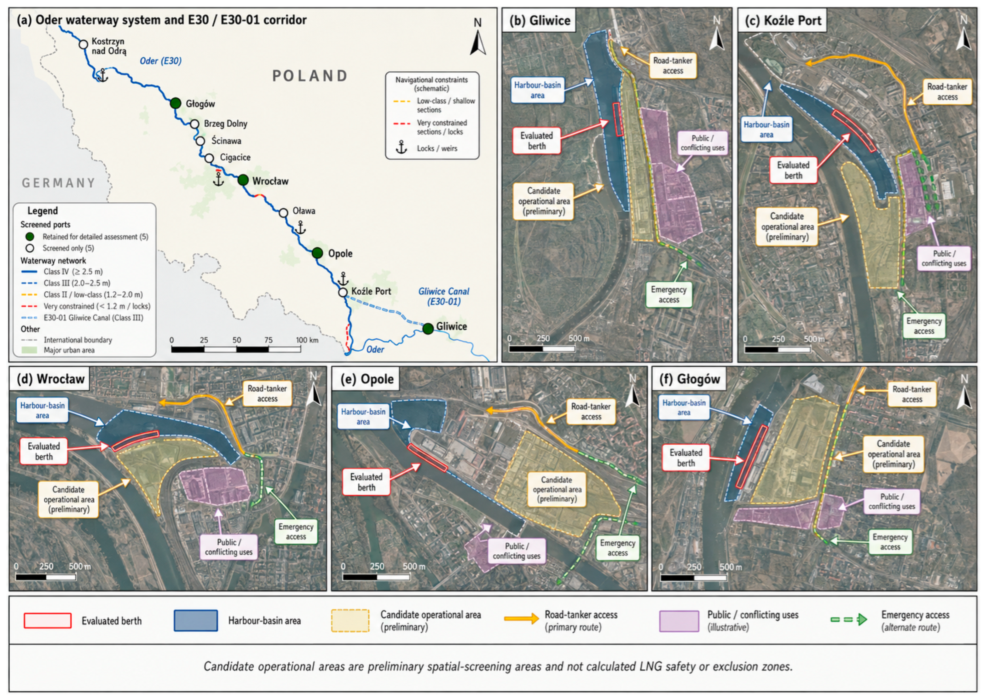
Selection for detailed analysis was based on evidence completeness, not on whether a location was expected to pass or fail the subsequent LNG screening. A location was retained for detailed assessment only where site-specific evidence was sufficient to evaluate waterside infrastructure, candidate transfer-area/access conditions, and evidence completeness using the common criterion framework. A “No—evidence incomplete” outcome indicates insufficient evidence for criterion-level assessment and does not constitute evidence of physical or regulatory infeasibility. The spatial distribution of the ten screened ports and the site-level geospatial evidence for the five detailed cases are shown in Figure 1.
Figure 1. Geospatial context of the ten screened ports and five detailed case-study locations in the Oder waterway system. Source: Authors’ elaboration based on Geoportal and the corresponding port and municipal spatial sources listed in Table 2.
Sustainability 18 09059 g001
Table 2. Preliminary screening of the ten inland-port locations.
PortBerthing EvidenceCandidate Area/AccessEvidence BasisDetailed Analysis
GliwiceIdentifiable technical quay/basinIndustrial area and HGV access identifiableGeoportal [50]; Port Gliwice [51]Yes
Koźle PortInfrastructure identifiable but heterogeneousCandidate area and road access identifiable; some conditions unverifiedGeoportal [50]; municipal port data [52]; spatial-planning data [53]Yes
WrocławBerthing infrastructure identifiableUrban/public-use conflicts and constrained accessGeoportal [50]; Wrocław spatial data [54]Yes
OpoleLimited berthing infrastructure identifiableRestricted urban area and constrained accessGeoportal [50]; Opole spatial data [55]Yes
GłogówPartial berthing infrastructure identifiableLimited separation and constrained accessGeoportal [50]; Port Głogów [56]Yes
CigaciceLimited berth evidenceTransfer-area geometry incompletely documentedGeoportal [50]; Port Cigacice [57]No—evidence incomplete
ŚcinawaRemaining port infrastructure partly documentedLandside conditions incompletely documentedGeoportal [50]; municipal data [58]No—evidence incomplete
Brzeg DolnyBerth-level evidence incompleteSpatial context identifiableGeoportal [50]; municipal GIS [59]No—evidence incomplete
OławaLimited continuity of transport-port functionsAccess conditions partly documentedGeoportal [50]; municipal GIS [60]No—evidence incomplete
Kostrzyn nad OdrąBerth-level evidence incompleteMixed local/recreational functionsGeoportal [50]; municipal map [61]No—evidence incomplete
Base-imagery metadata: Panel (Figure 1b), Gliwice—Geoportal Krajowy orthophoto/map layer and Port Gliwice spatial information [50,51], accessed on 17 August 2026; panel (Figure 1c), Koźle Port—Geoportal Krajowy and Kędzierzyn-Koźle municipal/spatial-planning data [50,52,53], accessed on 18 August 2026; panel (Figure 1d), Wrocław—Geoportal Krajowy and Wrocław Spatial Information System [50,54], accessed on 18 August 2026; panel (Figure 1e), Opole—Geoportal Krajowy and Opole Spatial Information System [50,55], accessed on 18 August 2026; panel (Figure 1f), Głogów—Geoportal Krajowy and Port Głogów information [50,56], accessed on 18 August 2026. Where the public interface did not expose the original imagery-acquisition date or spatial resolution, these metadata were treated as unavailable and were not inferred.
Panel (a) shows the ten inland ports included in the preliminary screening, the E30/E30-01 corridor, relevant waterway classes, principal navigational constraints, and the five locations retained for detailed assessment. Panels (b–f) present the site-level geospatial evidence for Gliwice, Koźle Port, Wrocław, Opole, and Głogów, respectively, including the evaluated berth and harbour-basin area, candidate operational area, road-tanker access, public or conflicting uses, and emergency access. The candidate operational areas represent preliminary spatial-screening areas and should not be interpreted as calculated LNG safety or exclusion zones.

2.2. Regulatory Applicability to LNG-Fuelled Inland Navigation in Poland

The regulatory basis relevant to LNG-fuelled inland navigation must be distinguished from maritime guidance developed primarily for seagoing ships. Within the European Union certification framework for inland waterway vessels, Directive (EU) 2016/1629 refers to the applicable ES-TRIN technical standard [62,63]. For the period considered in this study, ES-TRIN 2025/1 is the applicable edition within that framework [63,64]. ES-TRIN contains requirements concerning low-flashpoint fuels, while its Chapter 30 and Annex 8 provide the inland-vessel technical context for gaseous fuels, including LNG. The associated risk-assessment requirement is therefore more directly relevant to an EU inland vessel than the IMO IGF Code.
Competence requirements are likewise addressed within the inland-navigation framework. ES-QIN includes specific standards of competence for LNG experts, including knowledge and skills related to LNG systems and bunkering [65]. The carriage of dangerous goods by inland waterways is governed by the ADN framework and its implementation in Polish law, while delivery of LNG by road tanker is additionally subject to the road dangerous-goods regime. Polish inland-navigation legislation, dangerous-goods legislation, and generally applicable fire-protection requirements remain relevant to the vessel, transport, and landside components of a prospective operation [66,67,68,69,70]. The exact approval pathway for an individual bunkering installation would depend on its technical configuration, location, storage arrangements, construction scope, and operating model and was not determined in this desktop study. In Poland, the national legal framework relevant to the proposed operation additionally includes the Act of 21 December 2000 on Inland Navigation, the Act of 19 August 2011 on the Carriage of Dangerous Goods, together with the applicable ADR and ADN requirements, and the Act of 24 August 1991 on Fire Protection [67,68,69,70]. The administrative and operating approvals required for a specific LNG-bunkering arrangement are configuration- and location-dependent and must therefore be verified with the competent authorities and port/operator before implementation.
The IMO IGF Code, ISO 20519, EMSA guidance, SGMF guidance, and IAPH bunkering checklists remain useful technical references for hazard identification, interface management, operating procedures, and good practice [25,26,27,28,29]. However, where these instruments were developed for maritime shipping or operate as voluntary technical standards and guidance, they are used in this study as supplementary or analogous good practice rather than presented as independently establishing the legal requirements applicable to a Polish inland port. Regulation (EU) 2023/1804 is likewise treated as European alternative-fuel infrastructure policy context; its current mandatory liquefied-methane refuelling target concerns specified TEN-T maritime ports rather than constituting an operational authorisation regime for LNG bunkering in Polish inland ports [3].

3. Materials and Methods

3.1. Research Design, Scope and Case Selection

The study employed a comparative multiple-case study design supported by an ordinal multicriteria screening framework [42,43,44,45,46,71]. Port readiness was conceptualised as a systemic property arising from the interaction among technical infrastructure, spatial configuration, landside accessibility, potential bunkering arrangements, and operational safety requirements. Accordingly, the mere presence of a quay or road connection was not considered sufficient evidence that LNG bunkering could be undertaken safely, repeatedly, and without unacceptable interference with existing port functions. Operational risk was not quantified within the empirical assessment; instead, it was treated as a necessary pre-implementation consideration for ports identified as potential candidates for mobile LNG bunkering.
The ten-port preliminary screening is reported in Table 2. Five locations—Gliwice, Koźle Port, Wrocław, Opole, and Głogów—were retained for detailed assessment because sufficiently specific documentary and geospatial evidence was available for criterion-level classification and because the cases represented contrasting industrial, urban, and spatial conditions. Case selection was therefore based on evidence completeness and analytical variation rather than on a preliminary readiness score.
The assessment was not designed to identify locations that should automatically receive LNG-related investment. It examined whether the minimum technical, spatial, and accessibility conditions required for further implementation analysis were present. Economic viability, projected LNG sales, fleet-conversion potential, and expected investment returns were treated as contextual factors rather than direct inputs to the criterion-level classification because reliable port-level data on vessel fuel demand, route regularity, engine characteristics, and future LNG uptake were not consistently available across all analysed cases.
As an external positive benchmark, the logical structure of the framework was compared qualitatively with publicly documented LNG-bunkering capability in the Port of Rotterdam. Rotterdam was not included in the Polish port ranking, and no comparative ordinal score was calculated. The benchmark was used only to verify whether the framework recognises the types of evidence expected at a location with documented LNG bunkering: an identifiable transfer configuration, access and interface controls, bunkering-specific procedures and checklists, and an established operational framework. The comparison provides a face-validity check rather than statistical external validation. Public Port of Rotterdam documentation confirms that LNG bunkering is available in the port and provides an LNG-bunkering safety checklist specifically for inland shipping. These materials were used solely as a positive face-validity benchmark and not as a scored comparator [72,73].

3.2. Data Sources and Evidence Framework

The empirical evidence was compiled through a desk-based documentary and geospatial review conducted in July 2026. The assessment reflects publicly available information verified up to 23 July 2026. The orthophoto and map layers used to prepare Figure 1 were accessed again on 17–18 August 2026 for visualisation and source verification only; this later access did not alter the criterion classifications, which remained based on the evidence assessed at the adopted cut-off date. Statistical data referred primarily to 2023 and 2024, depending on the most recent official datasets available for the inland waterway network, transport activity, and fleet structure.
A predefined evidence hierarchy was applied. Current statutory, administrative, port-authority, and port-operator documentation was prioritised over official cadastral, topographic, spatial-planning, and orthophoto data, which in turn were prioritised over dated photographs and other georeferenced imagery. Where sources differed, the more authoritative, site-specific, and recent source was preferred when the discrepancy could be explained by acquisition date or documented site change. Unresolved contradictions and unavailable information were classified as NV (not verified) and were not interpreted as evidence of absence. For geospatial observations, the data provider and layer type were recorded. Where orthophoto metadata exposed an acquisition date and spatial resolution, these values were retained in the audit record. Where such metadata were not available through the public interface, the imagery was used only as corroborative evidence and was not used as the sole basis for assigning category 2 or for inferring missing quantitative dimensions. Conflicts between geospatial imagery and more authoritative documentary sources were resolved according to the source hierarchy described above.
The 0–1–2 categories are ordinal evidence categories and are not interpreted as equal-interval numerical measurements. An additional code, NV, was used where the available evidence was insufficient or contradictory [74]. NV was not converted to zero.
K2 is not an LNG safety-zone criterion. It assesses only whether the physical and functional layout provides a candidate area that could potentially be controlled during a future transfer operation. No hazard radius, exclusion distance, individual risk contour, or consequence zone was calculated. Any such distance must be established by a site-specific assessment incorporating the actual release scenario, LNG inventory, transfer rate, hose and connection arrangement, safeguards, weather conditions, simultaneous operations, ignition assumptions, and risk-acceptance criteria.
Official statistical data were used to characterise the Polish inland waterway network, transport activity, and fleet structure. Port-level evidence was obtained from publicly available port documentation, maps, spatial-planning materials, orthophotos, satellite imagery, technical descriptions, official photographs, and other verifiable administrative or operator records relating to the analysed locations.
The operational and safety layer was restricted to provisions that could be confirmed from publicly available documents. No interviews were conducted with port operators, LNG suppliers, vessel owners, or emergency services, and no on-site inspections were undertaken. The analysis therefore did not verify the actual competence of personnel, the practical effectiveness of emergency procedures, the technical condition of individual safety systems, or the formal readiness of a port to conduct LNG bunkering.
The absence of publicly available information was not automatically interpreted as evidence that a particular infrastructure element, procedure, or safeguard did not exist. Where a condition could not be verified reliably, it was classified as not verified and interpreted conservatively. Category 0 was assigned only when the available evidence positively indicated that the relevant criterion was not satisfied under the reference screening scenario. Category 1 represented partial or conditional evidence, whereas category 2 indicated that the available evidence supported the highest verification level defined for that criterion. Where evidence was insufficient or contradictory, NV was used instead of category 0.
Each criterion-level classification was accompanied by a concise evidence-based justification in the Results Section. This enabled the reader to assess the relationship between the available information, the assigned category, and the final screening outcome without requiring a separate supplementary evidence table.
As the study relied exclusively on publicly available documentary and geospatial information and did not involve human participants, personal data, interviews, or experimental procedures, ethics committee approval and informed consent were not required.

3.3. Operational Definition and Assessment Procedure

In this study, LNG port readiness was defined as the extent to which an inland port provides the conditions required to accommodate an LNG-fuelled vessel and potentially support at least one bunkering configuration under controlled spatial and operational conditions without materially compromising its existing functions. The definition comprised four interdependent components: a technically suitable berth and harbour basin, the ability to identify and control a candidate transfer area, adequate landside and emergency access, and a physically feasible LNG bunkering arrangement.
For consistency, the desktop assessment was referenced to a single screening scenario rather than to an unspecified LNG operation. The waterside reference was an inland cargo vessel within the Class IV dimensional envelope, approximately 80–85 m in length, 9.5 m in beam, and with a screening draught of up to approximately 2.5 m [47]. The landside reference was one LNG road semi-trailer tanker serving one vessel at a time. For landside-access screening, the tanker was represented by an articulated-road-vehicle envelope of up to 16.50 m in overall length and 2.55 m in width. Manoeuvring compatibility was referenced to a swept path with an outer radius of 12.50 m and an inner radius of 5.30 m. A screening gross combination mass of 40 t was used when considering the availability of pavement or load-capacity evidence [75]. For screening purposes, a nominal bunker volume (Vb) of approximately 40 m3 and a nominal transfer rate (Qb) of 20 m3/h through a single flexible cryogenic transfer hose were assumed. The corresponding nominal transfer duration (tb) was calculated as:
t b = V b Q b = 40   m 3 20   m 3 / h = 2   h
These values are analytical screening assumptions rather than specifications of a future bunkering system. The assumed operation excluded simultaneous cargo, passenger, or public activities within the candidate transfer area and required continuous emergency-service access.
These assumptions are screening inputs only. They do not constitute a bunker-system design basis and were not used to calculate an LNG hazard or exclusion distance. Actual vessel dimensions, bunker volume, tanker configuration, transfer rate, hose specification, connection arrangement, weather limits, and simultaneous-operation rules would have to be defined for a specific pilot project and incorporated into the subsequent risk assessment. Accordingly, a port that passes the present spatial screening is not thereby demonstrated to have an adequate LNG safety zone.
For K1, full verification required documented berth length compatible with the 80–85 m reference vessel and depth compatible with the 2.5 m screening draught. For K3, the highest category required documentary or geospatial confirmation of tanker access, manoeuvring capability, and emergency-service access. Where these parameters could not be verified, the highest category was not assigned. Missing quantitative dimensions were not inferred from imagery.
Readiness was not equated with the existence of permanent LNG infrastructure. A port could be prioritised for field verification where mobile truck-to-ship bunkering appeared physically plausible despite the absence of a permanent facility [25,26,27,28,29,30,31,39]. Such a classification did not confirm that the port was operationally prepared, as implementation would still require detailed engineering verification, formal approvals, operating procedures, trained personnel, and emergency-response arrangements [25,26,27,28,29,62,63,64,65,66,67,68,69,70]. Conversely, a technically suitable quay was not considered sufficient when access to the transfer area could not be controlled or when a candidate transfer area could not be identified or controlled from the available desktop evidence.
The analytical framework distinguished between system context, port-level readiness, and operational risk. The system context included waterway reliability, fleet structure, transport activity, and the possible concentration of fuel demand. These factors informed the interpretation of the results but were not assigned criterion categories. Port-level readiness was assessed using K1, K2, K3, K4a, and K4b; the ordinal categories were not summed, averaged, normalised, or numerically weighted. Operational risk was treated as a separate pre-implementation requirement rather than as a quantified component of the present assessment.
Hydrological reliability was kept outside the port-level gate because it is a time-varying corridor-access condition rather than a fixed port attribute. Passing the gate therefore does not imply year-round accessibility; route- and season-specific water levels, available draught, lock availability, and other navigational restrictions must be verified separately.
Separating these analytical levels prevented general characteristics of the national transport system, such as fleet size or the formal length of navigable waterways, from artificially improving the classification of a port that lacked essential local conditions. It also maintained a clear distinction between preliminary physical screening, field-verification priority, and confirmed operational capability.
The assessment was conducted in four sequential stages.
Stage 1: System and corridor screening. The inland waterway network, navigation classes, fleet structure, transport activity, and the functional profiles of individual ports were reviewed to identify locations in which repeated vessel calls and a potential demand for alternative fuel services could plausibly occur. This stage established the broader transport context and supported case selection but did not generate port-level criterion classifications.
Stage 2: Port-level evidence collection. Documentary and geospatial evidence concerning quays, harbour basins, landside access, neighbouring land uses, public accessibility, emergency-service access, and potential bunkering arrangements was collected for each location. The same categories of evidence were examined across all cases to ensure a consistent comparative procedure.
Stage 3: Ordinal criterion classification. Each of the five detailed cases was assessed using K1, K2, K3, K4a, and K4b. Categories 0, 1, and 2 represented ordered evidence states, while NV was used where evidence was insufficient or contradictory. The categories were not interpreted as equal-interval numerical measurements.
Stage 4: Critical-condition screening. For the reference truck-to-ship configuration, K1, K2, K3, and K4a were treated as necessary physical conditions. A value of 0 in any of these criteria resulted in “not demonstrated as feasible at preliminary desktop screening”, whereas NV resulted in “insufficient evidence for classification”. K4b was reported separately and did not compensate for a physical deficiency.
A port-specific operational risk assessment was not conducted within the present study. Detailed HAZID, HAZOP, FMEA, or quantitative risk analyses were treated as subsequent pre-implementation requirements for locations prioritised for field verification [76,77,78].
The criterion-level classifications were checked against Table 3 and the underlying evidence using a common protocol comprising Section 3.2 source hierarchy, reference scenario, criterion definitions, and NV rule. Ambiguous evidence was retained as NV or category 1 rather than forced into a definitive category. The complete matrix was then reclassified in two separate internal-consistency passes, which produced identical classifications. The repeated classification was used as an internal consistency check rather than as a formal inter-rater reliability assessment; consequently, no Cohen’s kappa statistic is reported. The study is therefore treated as an exploratory desktop screening, with category 2 reserved for fully verified conditions and robustness examined through one-category perturbations and alternative gates.

3.4. Ordinal Evidence Profiles and Critical-Condition Rule

The categories 0, 1 and 2 represent ordered states of evidence and were not treated as cardinal measurements. Consequently, criterion values were not added, averaged, normalised, or multiplied by numerical weights. Each port was represented by an ordinal evidence profile:
Pp = (K1,p, K2,p, K3,p, K4a,p, K4b,p).
where Pp denotes the ordinal evidence profile of port p. For each criterion, Kj,p ∈ {0,1,2} represents a verified ordinal evidence state, whereas Kj,p = NV indicates insufficient or contradictory evidence.
For the reference truck-to-ship screening configuration, let 𝒞TTS = {1,2,3,4a} denote the set of critical physical criteria. The preliminary gate outcome for port p was defined as:
B t t s ,   p = ND , if   j C TTS : K j , p = 0 IE , if   j C TTS : K j , p = 0   and   j C TTS : K j , p = NV PASS , if j C TTS : K j , p 1 , 2 .
Here, ND denotes “not demonstrated as feasible at preliminary desktop screening”, whereas IE denotes “insufficient evidence for classification”. Thus, favourable evidence in one criterion cannot compensate for failure of another critical physical condition, and NV is not treated as a numerical category.
Four descriptive outputs were used:
(i) 
Priority for field verification—all critical physical conditions passed the desktop gate, but operational LNG readiness was not established;
(ii) 
Documented operational preparation identified—the physical gate was passed and LNG-specific operational arrangements were documented, without implying regulatory authorisation;
(iii) 
Not demonstrated as feasible at preliminary desktop screening—at least one critical physical condition was rated 0 under the reference configuration;
(iv) 
Insufficient evidence for classification—at least one critical physical condition was NV.
The gate was expanded relative to the original formulation because the reference operation is truck-to-ship bunkering. Under this configuration, a berth and a controllable transfer area are necessary but not sufficient: a road tanker must also reach and leave the transfer position, and a complete vessel–tanker transfer arrangement must be physically identifiable. Treating K3 and K4a as critical therefore avoids the logical inconsistency in which a location could pass the truck-to-ship feasibility gate despite lacking tanker access or a feasible transfer arrangement. K4b remains separate because lack of publicly documented procedures does not establish physical impossibility, and because such arrangements may be developed during a subsequent implementation stage.
Robustness was examined without numerical weights using two complementary tests. First, the reference critical set CTTS = {1, 2, 3, 4a} was compared with the narrower set CN = {1, 2}. Second, one verified criterion classification was varied at a time to an adjacent ordinal state, defined as:
A ( k ) = { 1 } , if   k   =   0   { 0 , 2 } , if   k   =   1 { 1 } ,   if   k   =   2
Only adjacent changes considered plausible from the available evidence were tested. The gate was recalculated after each admissible one-criterion change. NV observations remained unresolved and were not converted into verified categories, while K4b remained outside the physical gate. Because the framework contains no numerical readiness classes, no sensitivity analysis based on numerical class boundaries was performed.

4. Results

4.1. System Context and Criterion-Level Results

The five ports selected for detailed assessment exhibited substantial differences in technical condition, spatial configuration, landside accessibility, and potential bunkering capability. The resulting criterion-level classifications are presented in Table 4, while the associated geospatial context and site-level evidence are illustrated in Figure 1.
For K1, all five detailed cases were classified as 1. In Gliwice, technical quay and harbour-basin infrastructure was documented, but exact berth length and available depth for the reference vessel were not verified in the reviewed public evidence [50,51]. Koźle Port was also classified as 1 because usable quay infrastructure was identifiable but heterogeneous [50,52,53]. Wrocław [50,54], Opole [50,55], and Głogów [50,56] were likewise classified as 1 because basic berthing infrastructure was identifiable but one or more relevant dimensional, technical, or operational parameters remained constrained or unverified.
The highest K1 and K3 categories were not assigned where the quantitative parameters required by Table 3 could not be verified. Missing berth, turning-radius, pavement, or load-capacity values were not inferred from imagery.
The greatest differentiation between the ports occurred under K2. Gliwice was classified as 2 because its industrial spatial structure and separation from intensively used public areas appeared to permit the identification of a candidate operational area that could potentially be controlled without major interference with other port functions [50,51]. Koźle Port was classified as 1. Its extensive port area and industrial character indicated that temporary spatial separation could be feasible; however, the available evidence did not confirm that the candidate area could be controlled without traffic reorganisation, access restrictions, or additional operational safeguards [50,52,53]. In contrast, Wrocław [50,54], Opole [50,55], and Głogów [50,56] were classified as 0. In these cases, existing urban uses, public accessibility, restricted port areas, or conflicts with neighbouring functions prevented the identification of a practicable candidate transfer area that could be segregated from uncontrolled public movement under the assessed conditions.
For K3, all five detailed cases were classified as 1. In Gliwice, HGV and emergency access was identifiable, but tanker manoeuvring geometry and pavement/load capacity were not fully verified [50,51]. In Koźle Port, HGV access was identifiable, while manoeuvring and emergency-access conditions remained partly unverified [50,52,53]. Wrocław [50,54], Opole [50,55], and Głogów [50,56] also showed identifiable but constrained or incompletely verified landside and emergency access.
The TTS access screening therefore considered the reference 16.50 m articulated-vehicle envelope, the 12.50/5.30 m swept-path geometry, and the availability of pavement/load-capacity evidence compatible with the 40 t screening case. Axle-specific quay-pavement load limits were not verified in the reviewed public sources and remain a requirement for subsequent field and engineering verification.
No publicly documented operational LNG-bunkering installation was identified in the reviewed material for the five detailed cases. This observation was recorded under K4b as documentary evidence status and was not used by itself to assign a physical-feasibility classification of 0. K4a was assessed separately from the geometry of the reference truck-to-ship arrangement. On this basis, a plausible physical TTS configuration could be identified for Gliwice and Koźle Port, whereas the available spatial evidence did not demonstrate such a configuration for Wrocław, Opole, or Głogów. Where LNG-specific procedures or arrangements could not be verified from public documentation, the observation was coded NV rather than interpreted as evidence of absence.

4.2. Critical-Condition Outcomes and Robustness

Table 4 provides the final criterion-level screening outcomes. Gliwice and Koźle Port passed the reference physical gate and were therefore classified as priorities for field verification; operational LNG readiness was not established. Wrocław, Opole, and Głogów did not pass the reference gate because K2 and K4a were classified as 0 and were therefore reported as “not demonstrated as feasible at preliminary desktop screening”. The critical-condition rule changed the decision interpretation rather than the underlying ordinal evidence profile: favourable evidence in other dimensions could not compensate for failure of a condition required by the reference TTS configuration.
The robustness tests produced the same overall grouping under the narrower K1 + K2 gate and the reference K1 + K2 + K3 + K4a gate. Wrocław, Opole, and Głogów remained outside the reference gate when either K2 or K4a was increased individually because the other critical criterion remained classified as 0. Gliwice was sensitive to a downward change from 1 to 0 in K1, K3, or K4a, whereas Koźle Port was sensitive to a downward change in any critical criterion classified as 1. No critical physical criterion was coded NV in the five detailed cases; therefore, an NV-based perturbation did not affect the physical-gate results. The two leading locations should consequently be interpreted as priorities for field verification rather than as robustly ready ports.

5. Discussion

The results show that readiness for LNG bunkering is determined by the interaction of several local conditions rather than by the presence of individual infrastructure elements. Basic berthing facilities were identified at all five analysed locations, but only Gliwice and Koźle Port also satisfied the minimum spatial requirements needed to pass the bottleneck gate. Wrocław, Opole, and Głogów did not pass the reference physical gate primarily because a separable and controllable candidate transfer area could not be identified from the available desktop evidence under the assessed spatial and functional conditions. This illustrates that the availability of a quay cannot compensate for permanent conflicts with public access, neighbouring land uses, or restricted operational space [10,11,12,13,14].
Gliwice showed the strongest overall evidence profile because its industrial character, harbour-basin configuration, landside accessibility, and separation from public functions jointly supported the potential use of the reference TTS configuration. Koźle Port showed an evidence profile warranting field verification, although several conditions remained unverified. Its industrial character and available port area supported further consideration, but uncertainties remained regarding quay availability, spatial organisation, tanker manoeuvring, and emergency-service access. Both ports should therefore be regarded as priorities for field verification rather than as operationally prepared facilities. Neither location was confirmed as having an operational LNG bunkering service, complete procedures, verified emergency arrangements, or the approvals required to conduct fuel-transfer operations.
The present results address a different decision stage from conventional LNG bunkering port-selection and infrastructure-planning models. Port-selection studies evaluate the relative attractiveness of candidate ports using criteria such as safety, service conditions, demand, connectivity, or cost, whereas recent infrastructure-planning models optimise the location and capacity of LNG supply under assumed demand and operational conditions. The present screening precedes those decisions. Its purpose is to determine whether sufficiently basic site-level physical conditions can be demonstrated before demand, investment, or network optimisation is justified. In this sense, the non-compensatory gate is not an alternative to optimisation but a preceding feasibility filter [35,36,37,38,39].
The importance of spatial conditions identified in the Polish cases is consistent with the broader LNG-safety literature in one important respect: safe bunkering cannot be inferred from the mere presence of a quay. Published LNG studies show that exclusion distances and risk depend on release characteristics, transfer equipment, simultaneous operations, safeguards, ignition assumptions, human performance, and emergency arrangements. This supports the revised interpretation of K2 as a spatial-controllability criterion rather than an LNG safety-zone assessment. A favourable K2 result therefore indicates only that a candidate area exists for subsequent risk-based design; it does not establish the dimensions or acceptability of the final exclusion zone [32,33,34,40,41].
Safety and separation requirements depend on the actual operation. The reference scenario excludes cargo, passenger, and uncontrolled public activity from the candidate transfer area; adjacent operations that prevent temporary segregation preclude K2 = 2, whereas additional traffic or access controls are consistent with K2 = 1. Likewise, smaller passenger vessels cannot be assumed to require shorter safety distances because LNG inventory, transfer rate, equipment, and safeguards may differ. Actual SIMOPS acceptability and separation distances require a project-specific risk assessment [25,26,32,33,34,40,41].
The framework may be transferable as a decision structure, but not as a fuel-neutral set of criteria. Other alternative fuels introduce different storage conditions, hazard mechanisms, transfer equipment, energy densities, emergency measures, and regulatory requirements. The transferable element is therefore the sequence—evidence audit, definition of a reference operation, ordinal site assessment, explicit critical-condition testing, and subsequent risk analysis—rather than the LNG-specific thresholds themselves. This distinction is increasingly important as ports prepare for multi-fuel energy systems and evaluate hydrogen, methanol, ammonia, electricity, and other alternatives [8,79,80,81].
Fuel-specific adaptation would mainly affect K2–K4. For ammonia, K2 and K4b would require stronger treatment of toxicity, exposure control, monitoring, and emergency procedures, with implications for K3. For hydrogen, K2, K4a, and K4b would require checks for the selected storage and transfer technology, leak detection, ventilation, ignition control, and fuel-specific separation. K1 remains relevant but must be redefined for the selected vessel and bunkering configuration [80,81].
Truck-to-ship bunkering was used as the reference screening configuration; the study did not compare truck-to-ship, ship-to-ship, and pipe-to-ship alternatives technically or economically and therefore does not identify TTS as the superior or optimal option. Furthermore the present study did not estimate LNG demand, investment costs, operating expenditure, or commercial returns. The identification of truck-to-ship bunkering as a potentially suitable configuration therefore represents an infrastructure and spatial conclusion rather than confirmation of economic viability.
Spatial transformation is particularly important in urban ports. The increasing integration of former port areas with residential, recreational, and publicly accessible waterfront functions may permanently restrict their capacity to accommodate operations requiring controlled access. In this context, the category-0 classifications assigned to K2 should not be interpreted as minor deficiencies that can necessarily be corrected through limited technical adaptation. In some locations, the conflict arises from the broader land-use structure and may therefore represent a long-term constraint [10,11,12,13,14].
LNG readiness can also be interpreted as a test of the adaptive capacity of inland ports. Requirements concerning access control, heavy-vehicle circulation, emergency access, operational separation, and coordinated safety procedures are relevant not only to LNG but also to other alternative fuels and energy systems. Nevertheless, the assessment criteria cannot be transferred directly to methanol, ammonia, hydrogen, biofuels, or shore-side electricity because each option has different infrastructure, safety, storage, and regulatory requirements [3,79,80,81].
Recent maritime-network studies complement this site-level perspective through LNG network optimisation and emission analysis [82], graph-based vessel and port-traffic analysis [83], port-competitiveness assessment [84], broader LNG-network reviews [85], and analyses of oil-price and COVID-19 disruptions [86,87]. Because these studies operate at network or port-system scale, they reinforce the distinction between network-level performance and site-specific infrastructure readiness.
Rail-based LNG delivery was not included in the reference screening scenario. Where road access is constrained but rail access is available, rail or intermodal LNG supply may alter the comparative logistics assessment and should be examined separately before implementation [88].
The findings are limited by reliance on public documentary and geospatial evidence without site inspections, interviews, engineering verification, demand/cost analysis, or site-specific risk assessment. Public sources and imagery may be incomplete, outdated, or insufficiently resolved, creating possible misclassification of current infrastructure, access, pavement, and operating conditions; some category-1 or NV judgements may therefore change after field verification. The results cannot be interpreted as investment recommendations, confirmation of operational safety, or evidence of adequate LNG exclusion distances. Further examination of Gliwice and Koźle Port requires field confirmation of berth conditions, tanker manoeuvring, transfer-area controllability, emergency arrangements, regulatory requirements, demand, and project-specific safety conditions.

6. Conclusions

This study developed and applied an ordinal, evidence-based desktop-screening framework to assess whether selected Polish inland-port locations warrant further investigation for LNG bunkering in the context of sustainable inland-navigation development. Rather than aggregating the 0–1–2 categories into a readiness index, the framework represents port-level evidence as ordinal criterion profiles and applies explicit non-compensatory conditions for a reference truck-to-ship configuration. Based on the documentary and geospatial evidence available at the adopted cut-off date, Gliwice and Koźle Port provide the strongest basis for subsequent field verification. This finding does not establish LNG readiness, but indicates that the critical physical conditions required by the reference configuration were not contradicted by the available evidence. In contrast, feasibility of the reference configuration was not demonstrated for Wrocław, Opole, and Głogów, primarily because of spatial constraints, existing urban or public functions, access-control limitations, and difficulties in identifying a separable transfer arrangement. These results should not be interpreted as proof that LNG bunkering is physically or legally impossible at these locations.
Truck-to-ship bunkering was used solely as a reference screening configuration and was not demonstrated to be technically or economically superior to ship-to-ship or pipe-to-ship alternatives. No LNG safety-zone dimensions or operational risks were calculated; therefore, any implementation decision requires field measurements, engineering verification, demand analysis, site-specific risk assessment, emergency planning, stakeholder coordination, and applicable regulatory approvals. The broader contribution of the proposed framework lies in distinguishing preliminary spatial and infrastructure screening from site-specific safety and engineering verification and subsequent investment or operational decision-making. This distinction supports proportionate infrastructure planning and helps avoid premature investment in alternative-fuel solutions that are not supported by local technical and spatial conditions.

Author Contributions

Conceptualization, E.O.; methodology, E.O. and D.J.; investigation, E.O., J.D. and D.J.; resources, E.O., J.D. and D.J.; writing—original draft preparation, E.O., J.D. and D.J.; writing—review and editing, E.O., J.D. and D.J.; visualisation, E.O., J.D. and D.J. All authors have read and agreed to the published version of the manuscript.

Funding

This research received no external funding.

Institutional Review Board Statement

Not applicable.

Informed Consent Statement

Not applicable.

Data Availability Statement

The original contributions presented in the study are included in the article; further inquiries can be directed to the corresponding author.

Conflicts of Interest

The authors declare no conflicts of interest.

References

  1. European Commission. Sustainable and Smart Mobility Strategy—Putting European Transport on Track for the Future; COM(2020) 789 Final; European Commission: Brussels, Belgium, 2020; Available online: https://eur-lex.europa.eu/legal-content/EN/TXT/?uri=CELEX:52020DC0789 (accessed on 20 May 2026).
  2. European Commission. NAIADES III: Boosting Future-Proof European Inland Waterway Transport; COM(2021) 324 Final; European Commission: Brussels, Belgium, 2021; Available online: https://eur-lex.europa.eu/legal-content/EN/TXT/?uri=CELEX:52021DC0324 (accessed on 20 May 2026).
  3. European Parliament; Council of the European Union. Regulation (EU) 2023/1804 of the European Parliament and of the Council of 13 September 2023 on the deployment of alternative fuels infrastructure, and repealing Directive 2014/94/EU. Off. J. Eur. Union 2023, L 234, 1–47. Available online: https://eur-lex.europa.eu/eli/reg/2023/1804/oj (accessed on 20 May 2026).
  4. Balcombe, P.; Brierley, J.; Lewis, C.; Skatvedt, L.; Speirs, J.; Hawkes, A.; Staffell, I. How to decarbonise international shipping: Options for fuels, technologies and policies. Energy Convers. Manag. 2019, 182, 72–88. [Google Scholar] [CrossRef] [Scilit]
  5. Bouman, E.A.; Lindstad, E.; Rialland, A.I.; Strømman, A.H. State-of-the-art technologies, measures, and potential for reducing GHG emissions from shipping—A review. Transp. Res. Part D Transp. Environ. 2017, 52, 408–421. [Google Scholar] [CrossRef] [Scilit]
  6. Serra, P.; Fancello, G. Towards the IMO’s GHG goals: A critical overview of the perspectives and challenges of the main options for decarbonizing international shipping. Sustainability 2020, 12, 3220. [Google Scholar] [CrossRef] [Scilit]
  7. Christodoulou Raftis, C.; Vanelslander, T.; Van Hassel, E. A Global Analysis of Emissions, Decarbonization, and Alternative Fuels in Inland Navigation—A Systematic Literature Review. Sustainability 2023, 15, 14173. [Google Scholar] [CrossRef] [Scilit]
  8. Remoundos, G.; Kotrikla, A.M.; Lekakou, M.; Polydoropoulou, A.; Papaioannou, G.; Pervanas, I.; Kosmadakis, G.; Contarinis, S. A Multi-Criteria Decision-Support Framework for Evaluating Alternative Fuels and Technologies Toward Zero Emission Shipping. J. Mar. Sci. Eng. 2026, 14, 346. [Google Scholar] [CrossRef] [Scilit]
  9. Statistics Poland. Inland Waterways Transport in Poland in 2024; Statistics Poland: Warsaw, Poland, 2025. Available online: https://stat.gov.pl/files/gfx/portalinformacyjny/en/defaultaktualnosci/3323/10/15/1/inland_waterways_transport_in_poland_in_2024.pdf (accessed on 28 May 2026).
  10. Hoyle, B.S. The port–city interface: Trends, problems and examples. Geoforum 1989, 20, 429–435. [Google Scholar] [CrossRef] [Scilit]
  11. Hoyle, B. Global and local change on the port–city waterfront. Geogr. Rev. 2000, 90, 395–417. [Google Scholar] [CrossRef] [Scilit]
  12. Daamen, T.A.; Vries, I. Governing the European port–city interface: Institutional impacts on spatial projects between city and port. J. Transp. Geogr. 2013, 27, 4–13. [Google Scholar] [CrossRef] [Scilit]
  13. Hesse, M. Approaching the relational nature of the port–city interface in Europe: Ties and tensions between seaports and the urban. Tijdschr. Econ. Soc. Geogr. 2018, 109, 210–223. [Google Scholar] [CrossRef] [Scilit]
  14. Notteboom, T.; Pallis, A.; Rodrigue, J.-P. Port Economics, Management and Policy; Routledge: New York, NY, USA, 2022. [Google Scholar] [CrossRef] [Scilit]
  15. Bengtsson, S.; Andersson, K.; Fridell, E. A comparative life cycle assessment of marine fuels: Liquefied natural gas and three other fossil fuels. Proc. Inst. Mech. Eng. Part M J. Eng. Marit. Environ. 2011, 225, 97–110. [Google Scholar] [CrossRef] [Scilit]
  16. Brynolf, S.; Fridell, E.; Andersson, K. Environmental assessment of marine fuels: Liquefied natural gas, liquefied biogas, methanol and bio-methanol. J. Clean. Prod. 2014, 74, 86–95. [Google Scholar] [CrossRef] [Scilit]
  17. Thomson, H.; Corbett, J.J.; Winebrake, J.J. Natural gas as a marine fuel. Energy Policy 2015, 87, 153–167. [Google Scholar] [CrossRef] [Scilit]
  18. Anderson, M.; Salo, K.; Fridell, E. Particle- and gaseous emissions from an LNG powered ship. Environ. Sci. Technol. 2015, 49, 12568–12575. [Google Scholar] [CrossRef] [Scilit] [PubMed]
  19. Deng, J.; Wang, X.; Wei, Z.; Wang, L.; Wang, C.; Chen, Z. A review of NOx and SOx emission reduction technologies for marine diesel engines and the potential evaluation of liquefied natural gas fuelled vessels. Sci. Total Environ. 2021, 766, 144319. [Google Scholar] [CrossRef] [Scilit] [PubMed]
  20. Ushakov, S.; Stenersen, D.; Einang, P.M. Methane slip from gas fuelled ships: A comprehensive summary based on measurement data. J. Mar. Sci. Technol. 2019, 24, 1308–1325. [Google Scholar] [CrossRef] [Scilit]
  21. Balcombe, P.; Heggo, D.A.; Harrison, M. Total methane and CO2 emissions from liquefied natural gas carrier ships: The first primary measurements. Environ. Sci. Technol. 2022, 56, 9632–9640. [Google Scholar] [CrossRef] [Scilit] [PubMed]
  22. Jang, H.; Jeong, B.; Zhou, P.; Ha, S.; Nam, D. Demystifying the lifecycle environmental benefits and harms of LNG as marine fuel. Appl. Energy 2021, 292, 116869. [Google Scholar] [CrossRef] [Scilit]
  23. Balcombe, P.; Staffell, I.; Kerdan, I.G.; Speirs, J.F.; Brandon, N.P.; Hawkes, A.D. How can LNG-fuelled ships meet decarbonisation targets? An environmental and economic analysis. Energy 2021, 227, 120462. [Google Scholar] [CrossRef] [Scilit]
  24. Pavlenko, N.; Comer, B.; Zhou, Y.; Clark, N.; Rutherford, D. The Climate Implications of Using LNG as a Marine Fuel; International Council on Clean Transportation: Washington, DC, USA, 2020; Available online: https://theicct.org/publication/the-climate-implications-of-using-lng-as-a-marine-fuel/ (accessed on 28 May 2026).
  25. ISO 20519:2021; Ships and Marine Technology—Specification for Bunkering of Liquefied Natural Gas Fuelled Vessels. International Organization for Standardization: Geneva, Switzerland, 2021.
  26. European Maritime Safety Agency. Guidance on LNG Bunkering to Port Authorities and Administrations; EMSA: Lisbon, Portugal, 2018; Available online: https://www.emsa.europa.eu/publications/reports/item/3207-guidance-on-lng-bunkering-to-port-authorities-and-administrations.html (accessed on 28 May 2026).
  27. International Maritime Organization. International Code of Safety for Ships Using Gases or Other Low-Flashpoint Fuels (IGF Code); Resolution MSC.391(95); IMO: London, UK, 2015; Available online: https://www.imo.org/en/ourwork/safety/pages/igf-code.aspx (accessed on 28 May 2026).
  28. Society for Gas as a Marine Fuel. LNG as a Marine Fuel—Safety and Operational Guidelines—Bunkering; SGMF: London, UK, 2021; Available online: https://sgmf.info/product/fp07-01_lng-as-a-marine-fuel-safety-and-operational-guidelines-bunkering/ (accessed on 30 May 2026).
  29. International Association of Ports and Harbors. Liquefied Gas Bunker Checklist—Truck to Ship, Version T 4.1; IAPH: Tokyo, Japan, 2025; Available online: https://www.iaphworldports.org/n-iaph/wp-content/uploads/2025/09/IAPH_Liquefied_Gas_Bunker_Checklist_TTS_T_v4.1_FINAL_26-March-2025.pdf (accessed on 30 May 2026).
  30. American Bureau of Shipping. LNG Bunkering: Technical and Operational Advisory; ABS: Houston, TX, USA, 2015; Available online: https://ww2.eagle.org/content/dam/eagle/advisories-and-debriefs/ABS_LNG_Bunkering_Advisory.pdf (accessed on 30 May 2026).
  31. Calderón, M.; Illing, D.; Veiga, J. Facilities for bunkering of liquefied natural gas in ports. Transp. Res. Procedia 2016, 14, 2431–2440. [Google Scholar] [CrossRef] [Scilit]
  32. Fan, H.; Enshaei, H.; Jayasinghe, S.G. Safety philosophy and risk analysis methodology for LNG bunkering simultaneous operations (SIMOPs): A literature review. Saf. Sci. 2021, 136, 105150. [Google Scholar] [CrossRef] [Scilit]
  33. Aneziris, O.; Gerbec, M.; Koromila, I.; Nivolianitou, Z.; Pilo, F.; Salzano, E. Safety guidelines and a training framework for LNG storage and bunkering at ports. Saf. Sci. 2021, 138, 105212. [Google Scholar] [CrossRef] [Scilit]
  34. Gerbec, M.; Aneziris, O. Uncertainties in failure rates in the LNG bunkering risk assessment. Saf. Sci. 2022, 152, 105774. [Google Scholar] [CrossRef] [Scilit]
  35. Kim, A.-R.; Kwak, D.-W.; Seo, Y.-J. Evaluation of liquefied natural gas bunkering port selection. Int. J. Logist. Res. Appl. 2021, 24, 213–226. [Google Scholar] [CrossRef] [Scilit]
  36. Guo, Y.; Yan, R.; Qi, J.; Liu, Y.; Wang, S.; Zhen, L. LNG bunkering infrastructure planning at port. Multimodal Transp. 2024, 3, 100134. [Google Scholar] [CrossRef] [Scilit]
  37. Park, N.K.; Park, S.K. A study on the estimation of facilities in LNG bunkering terminal by simulation—Busan Port case. J. Mar. Sci. Eng. 2019, 7, 354. [Google Scholar] [CrossRef] [Scilit]
  38. Lu, W.; Seo, J.-H.; Yeo, G.-T. Location selection of an LNG bunkering port in Korea. J. Korea Trade 2019, 23, 59–75. [Google Scholar] [CrossRef] [Scilit]
  39. Yao, A.F.; Sèbe, M.; Recuero Virto, L.; Nassiri, A.; Dumez, H. The effect of LNG bunkering on port competitiveness using multilevel data analysis. Transp. Res. Part D Transp. Environ. 2024, 132, 104240. [Google Scholar] [CrossRef] [Scilit]
  40. Jeong, B.; Lee, B.S.; Zhou, P. Evaluation of safety exclusion zone for LNG bunkering station on LNG-fuelled ships. J. Mar. Eng. Technol. 2017, 16, 121–144. [Google Scholar] [CrossRef] [Scilit]
  41. Park, S.-I.; Paik, J.K. A hybrid method for the safety zone design in truck-to-ship LNG bunkering. Ocean Eng. 2022, 243, 110200. [Google Scholar] [CrossRef] [Scilit]
  42. Belton, V.; Stewart, T.J. Multiple Criteria Decision Analysis: An Integrated Approach; Kluwer Academic Publishers: Boston, MA, USA, 2002. [Google Scholar] [CrossRef] [Scilit]
  43. Roy, B. Multicriteria Methodology for Decision Aiding; Kluwer Academic Publishers: Dordrecht, The Netherlands, 1996. [Google Scholar] [CrossRef] [Scilit]
  44. Greco, S.; Ehrgott, M.; Figueira, J.R. (Eds.) Multiple Criteria Decision Analysis: State of the Art Surveys, 2nd ed.; Springer: New York, NY, USA, 2016. [Google Scholar] [CrossRef] [Scilit]
  45. Cinelli, M.; Kadziński, M.; Gonzalez, M.; Słowiński, R. How to support the application of multiple criteria decision analysis? Let us start with a comprehensive taxonomy. Omega 2020, 96, 102261. [Google Scholar] [CrossRef] [Scilit] [PubMed]
  46. Munda, G. Social multi-criteria evaluation: Methodological foundations and operational consequences. Eur. J. Oper. Res. 2004, 158, 662–677. [Google Scholar] [CrossRef] [Scilit]
  47. United Nations Economic Commission for Europe. Inventory of Main Standards and Parameters of the E Waterway Network: Blue Book, 4th ed.; ECE/TRANS/SC.3/144/Rev.4; United Nations: Geneva, Switzerland, 2024; Available online: https://unece.org/transport/standards/transport/inventory-main-standards-and-parameters-e-waterway-network-blue-book (accessed on 20 July 2026).
  48. United Nations Economic Commission for Europe. European Agreement on Main Inland Waterways of International Importance (AGN); United Nations: Geneva, Switzerland, 1996; Available online: https://unece.org/sites/default/files/datastore/fileadmin/DAM/trans/doc/2012/sc3wp3/ECE-TRANS-120r2efr-forWeb.pdf (accessed on 19 July 2026).
  49. Ministry of Infrastructure. Kanał Gliwicki—Inwestycje, które przywróciły życie transportowi wodnemu. Available online: https://www.gov.pl/web/infrastruktura/kanal-gliwicki--inwestycje-ktore-przywrocily-zycie-transportowi-wodnemu (accessed on 20 July 2026).
  50. Head Office of Geodesy and Cartography. Geoportal Krajowy. Available online: https://www.geoportal.gov.pl/pl/aplikacje/geoportal-krajowy/ (accessed on 5 July 2026).
  51. Śląskie Centrum Logistyki S.A. Port Gliwice. Available online: https://scl.com.pl/port-gliwice/ (accessed on 21 July 2026).
  52. Urząd Miasta Kędzierzyn-Koźle. Port. Available online: https://www.kedzierzynkozle.pl/pl/strona/port (accessed on 21 July 2026).
  53. Urząd Miasta Kędzierzyn-Koźle. Dane przestrzenne i miejscowe plany zagospodarowania przestrzennego. Available online: https://bip.kedzierzynkozle.pl/artykuly/1551/dane-przestrzenne (accessed on 21 July 2026).
  54. Urząd Miejski Wrocławia. System Informacji Przestrzennej Wrocławia. Available online: https://geoportal.wroclaw.pl/ (accessed on 21 July 2026).
  55. Urząd Miasta Opola. System Informacji Przestrzennej UM Opola. Available online: https://arcgisportal.um.opole.pl/portal/home/index.html (accessed on 21 July 2026).
  56. Port Rzeczny Głogów. O porcie. Available online: https://port.glogow.pl/ (accessed on 21 July 2026).
  57. Ośrodek Sportu i Rekreacji “Sulechowianka”. Port Cigacice. Available online: https://www.osir.sulechow.pl/port-cigacice/ (accessed on 5 July 2026).
  58. Urząd Miasta i Gminy Ścinawa. Innowacyjna Infrastruktura Turystyczna w Porcie. Available online: https://e-legnickie.pl/gospodarka-i-inwestycje/lubin/53910-innowacyjna-infrastruktura-w-porcie-scinawa (accessed on 15 July 2026).
  59. Urząd Miejski w Brzegu Dolnym. SIP Brzeg Dolny—System Informacji Przestrzennej. Available online: https://sip.gison.pl/brzegdolny (accessed on 15 July 2026).
  60. Urząd Miejski w Oławie. mOława—System Informacji Przestrzennej. Available online: https://molawa.e-mapa.net/ (accessed on 21 July 2026).
  61. Urząd Miasta Kostrzyn nad Odrą. Portal Mapowy. Available online: https://www.kostrzyn.pl/strona-66-miasto.html (accessed on 21 July 2026).
  62. European Parliament; Council of the European Union. Directive (EU) 2016/1629 of the European Parliament and of the Council of 14 September 2016 laying down technical requirements for inland waterway vessels. Off. J. Eur. Union 2016, L 252, 118–176. [Google Scholar]
  63. European Commission. Commission Delegated Regulation (EU) 2025/2177 of 9 September 2025 amending Directive (EU) 2016/1629 of the European Parliament and of the Council to update the reference to the most recent European Standard laying down Technical Requirements for Inland Navigation Vessels (ES-TRIN 2025). Off. J. Eur. Union 2025, 2025/2177. Available online: https://eur-lex.europa.eu/eli/reg_del/2025/2177/oj/eng (accessed on 22 July 2026).
  64. European Committee for Drawing up Standards in the Field of Inland Navigation (CESNI). European Standard Laying Down Technical Requirements for Inland Navigation Vessels (ES-TRIN), Edition 2025/1; CESNI: Strasbourg, France, 2025. [Google Scholar]
  65. European Committee for Drawing up Standards in the Field of Inland Navigation (CESNI). European Standard for Qualifications in Inland Navigation (ES-QIN), Edition 2024/1; CESNI: Strasbourg, France, 2024. [Google Scholar]
  66. United Nations Economic Commission for Europe. European Agreement concerning the International Carriage of Dangerous Goods by Inland Waterways (ADN 2025); United Nations: Geneva, Switzerland, 2025. [Google Scholar]
  67. Republic of Poland. Act of 21 December 2000 on Inland Navigation; Consolidated Text. Journal of Laws, 8 January 2025; item 18.
  68. Republic of Poland. Act of 19 August 2011 on the Carriage of Dangerous Goods; Consolidated Text. Journal of Laws, 26 April 2024; item 643.
  69. Republic of Poland. Act of 24 August 1991 on Fire Protection; Consolidated Text. Journal of Laws, 13 February 2025; item 188.
  70. Republic of Poland. Government Statement of 6 March 2025 on the Entry into Force of Amendments to Annexes A and B to the Agreement Concerning the International Carriage of Dangerous Goods by Road (ADR) done at Geneva on 30 September 1957. Journal of Laws, 16 May 2025; item 642.
  71. Yin, R.K. Case Study Research and Applications: Design and Methods, 6th ed.; SAGE Publications: Thousand Oaks, CA, USA, 2018. [Google Scholar]
  72. Port of Rotterdam Authority. LNG. Port of Rotterdam, Rotterdam, The Netherlands. Available online: https://www.portofrotterdam.com/en/logistics/cargo/lng (accessed on 17 August 2026).
  73. Port of Rotterdam Authority. Inland Shipping Forms and Checklists. Port of Rotterdam, Rotterdam, The Netherlands. Available online: https://www.portofrotterdam.com/en/inland-shipping/inland-shipping-forms-and-checklists (accessed on 17 August 2026).
  74. Stevens, S.S. On the theory of scales of measurement. Science 1946, 103, 677–680. [Google Scholar] [CrossRef] [Scilit] [PubMed]
  75. Council of the European Union. Council Directive 96/53/EC of 25 July 1996 laying down for certain road vehicles circulating within the Community the maximum authorised dimensions in national and international traffic and the maximum authorised weights in international traffic. Off. J. Eur. Communities 1996, L 235, 59–75. [Google Scholar]
  76. ISO 31000:2018; Risk Management—Guidelines. International Organization for Standardization: Geneva, Switzerland, 2018.
  77. IEC 31010:2019; Risk Management—Risk Assessment Techniques. International Electrotechnical Commission: Geneva, Switzerland, 2019.
  78. Center for Chemical Process Safety. Guidelines for Hazard Evaluation Procedures, 3rd ed.; John Wiley & Sons: Hoboken, NJ, USA, 2008. [Google Scholar] [CrossRef] [Scilit]
  79. International Maritime Organization. Interim Guidelines for the Safety of Ships Using Methyl/Ethyl Alcohol as Fuel; MSC.1/Circ.1621; IMO: London, UK, 2020. [Google Scholar]
  80. European Maritime Safety Agency. Potential of Ammonia as Fuel in Shipping; EMSA: Lisbon, Portugal, 2022. [Google Scholar]
  81. European Maritime Safety Agency. Potential of Hydrogen as Fuel for Shipping; EMSA: Lisbon, Portugal, 2023. [Google Scholar]
  82. Yu, H.; Wu, W.; Zhang, X.; Fang, Z.; Fu, X.; Xu, L.; Liu, J. Optimization-based global liquefied natural gas shipping network management for emission reduction. Ocean Eng. 2025, 321, 120366. [Google Scholar] [CrossRef] [Scilit]
  83. Yu, H.; Bai, X.; Liu, J. Ship Behavior Pattern Analysis Based on Graph Theory: A Case Study in Tianjin Port. J. Mar. Sci. Eng. 2023, 11, 2227. [Google Scholar] [CrossRef] [Scilit]
  84. Yu, H.; Guo, Z.; Xu, L. Research on Port Competitiveness Dynamics in China Under the Background of Free Trade Zone and Port Integration. Sustainability 2025, 17, 5502. [Google Scholar] [CrossRef] [Scilit]
  85. Liu, J.; Wu, W.; Fu, X.; Cai, J.; Yu, H. Global LNG Maritime Transportation Network: A Systematic Review of Progress and Trends. Energies 2026, 19, 2813. [Google Scholar] [CrossRef] [Scilit]
  86. Yu, H.; Fang, Z.; Lu, F.; Murray, A.T.; Zhang, H.; Peng, P.; Mei, Q.; Chen, J. Impact of oil price fluctuations on tanker maritime network structure and traffic flow changes. Appl. Energy 2019, 237, 390–403. [Google Scholar] [CrossRef] [Scilit]
  87. Yu, H.; Chen, F. Quantitative analysis of the efficiency dynamics of global liquefied natural gas shipping under COVID-19. Digit. Transp. Saf. 2024, 3, 19–35. [Google Scholar] [CrossRef] [Scilit]
  88. GATX Rail Europe. GATX and Trifleet Advance Sustainable Transport with Innovative LNG Transport Solution, 2022. Available online: https://www.gatx.eu/news/gatx-and-trifleet-advance-sustainable-transport-with-innovative-lng-transport-solution/ (accessed on 18 August 2026).
Table 1. Position of the proposed framework relative to selected LNG and multicriteria approaches.
ApproachMain Decision ProblemAggregationHard/Non-Compensatory ConditionsSpatial/Site EvidenceLNG Risk AssessmentValidation
LNG bunkering port-selection models [35,38]Choice/ranking of candidate portsUsually weighted/compensatoryGenerally not the central mechanismMostly port/regional indicatorsLimited or external to the rankingCase/application-based
LNG infrastructure-planning models [36,37]Capacity, location and supply-network optimisationOptimisation/cost-demand functionsTechnical constraints incorporated in optimisationNetwork/port-levelNot the principal outputScenario/model validation
LNG safety-zone/risk studies [32,33,34,40,41]Safe transfer configuration and accident consequencesRisk-basedAcceptance criteria and hazard scenariosSite/configuration-specificExplicitCase/scenario-based
Alternative-fuel/port MCDA [8,35,42,43,44,45,46]Ranking of alternativesWeighted multicriteria proceduresMethod-dependentUsually indicator-basedOne criterion among severalExpert/sensitivity analysis
Present studyPreliminary inland-port screening before engineering analysisNo arithmetic aggregation of ordinal categoriesExplicit critical-condition gatePort-specific documentary and geospatial audit trailNot quantified; deferred to site-specific studyExternal positive benchmark; repeated internal-consistency reclassification; qualitative validation only
Table 3. Criteria and ordinal evidence categories used in the preliminary desktop screening.
Criterion012
K1 Berthing and harbour-basin compatibilityAvailable documented geometry is incompatible with the reference vessel or a physical obstruction prevents use of the candidate berthBerthing appears physically possible for the reference envelope, but at least one relevant dimension, technical parameter, condition, or operational-availability characteristic remains restricted or unverifiedDocumentary/geospatial evidence verifies a usable berth, sufficient depth for the screening draught, adequate berth length and manoeuvring space, and operational availability for the reference vessel
K2 Spatial controllability of candidate transfer areaExisting fixed/public uses or physical layout provide no identifiable location in which the immediate transfer operation could be segregated from uncontrolled public movementA candidate area can be identified, but temporary closures, traffic reorganisation or additional access control would be requiredA physically separable candidate operational area with controllable access is evident from the available data
K3 Landside tanker and emergency accessPhysical geometry or access restrictions prevent a road tanker or emergency vehicle from reaching the candidate areaHGV/emergency access is identifiable, but at least one relevant condition—turning envelope, pavement/load capacity, route separation, entry/exit, access control, or emergency-service passage—remains constrained or unverifiedDocumentary/geospatial evidence verifies a continuous HGV route compatible with the reference articulated vehicle, including the 12.50/5.30 m swept-path envelope, access to and exit from the transfer position, pavement/load capacity compatible with the 40 t screening case, and unobstructed emergency-service access
K4a Physical feasibility of reference TTS configurationNo arrangement can be identified in which the reference vessel, tanker and transfer interface can be co-located without a documented critical spatial conflictA plausible arrangement can be drawn from the evidence but requires field confirmation of one or more dimensions or operating constraintsThe available evidence supports the complete reference arrangement without an identified critical physical conflict
K4b Documented operational preparednessAvailable documentation positively establishes that required arrangements are absent or not authorisedSome relevant procedures, emergency arrangements, responsibilities or operational controls are documented, but the full LNG-specific set is incompleteLNG-specific configuration, procedures, emergency arrangements, responsibilities and relevant approvals are documented
Note: K2 also reflects surrounding land-use conflicts, including urban development and public waterfront use. Broader environmental constraints, including renaturalisation measures, are treated as external planning conditions requiring site-specific verification.
Table 4. Criterion-level evidence and preliminary desktop-screening outcome.
PortK1K2K3K4aK4bOutcome
Gliwice1—technical quay and harbour basin documented, but exact berth length and available depth for the reference vessel were not verified in the reviewed public evidence; sources: Geoportal [50] and Port Gliwice [51]2—separable industrial candidate area; sources: Geoportal [50] and Port Gliwice [51]1—HGV and emergency access identifiable, but tanker manoeuvring geometry and pavement/load capacity were not fully verified; sources: Geoportal [50] and Port Gliwice [51]1—plausible TTS arrangement; field dimensions require verification; sources: Geoportal [50] and Port Gliwice [51]NV—LNG-specific procedures/approvals not verified in the reviewed public documentation [51]Priority for field verification
Koźle Port1—usable but heterogeneous quay infrastructure [50,52,53]1—candidate area identifiable; additional control measures require verification [50,52,53]1—HGV and emergency access is identifiable, but compatibility with the reference tanker swept-path envelope and pavement/load capacity remained partly unverified [50,52,53]1—plausible TTS arrangement requiring field verification [50,52,53]NV—LNG-specific procedures/approvals not verified in the reviewed public documentation [52,53]Priority for field verification
Wrocław1—berth infrastructure identifiable, but berth length and available depth for the reference vessel were not fully verified [50,54]0—urban/public uses prevent identification of a separable candidate area [50,54]1—HGV and emergency access is identifiable, but compatibility with the reference 16.50 m articulated vehicle, the 12.50/5.30 m swept-path envelope, and pavement/load capacity for the 40 t screening case was not fully verified [50,54]0—reference TTS arrangement not demonstrated [50,54]NV—LNG-specific procedures/approvals not verified in the reviewed public documentation [54]Not demonstrated as feasible at preliminary desktop screening
Opole1—limited berth infrastructure identifiable; reference-vessel berth length and available depth were not fully verified [50,55]0—restricted urban port area prevents separable candidate area [50,55]1—HGV and emergency access is identifiable, but manoeuvring compatibility with the reference articulated vehicle and pavement/load capacity for the 40 t screening case remained constrained or unverified [50,55]0—reference TTS arrangement not demonstrated [50,55]NV—LNG-specific procedures/approvals not verified in the reviewed public documentation [55]Not demonstrated as feasible at preliminary desktop screening
Głogów1—partial berthing capability identifiable; reference-vessel berth length and available depth were not fully verified [50,56]0—insufficient spatial separation [50,56]1—HGV and emergency access is identifiable, but the reference tanker manoeuvring envelope and pavement/load capacity were not fully verified from the available evidence [50,56]0—reference TTS arrangement not demonstrated [50,56]NV—LNG-specific procedures/approvals not verified in the reviewed public documentation [56]Not demonstrated as feasible at preliminary desktop screening
Note: Reference parameters used in Table 4: K1 was assessed against the 80–85 m reference-vessel envelope and a screening draught of 2.5 m; K3 against an articulated vehicle up to 16.50 m long and 2.55 m wide, a 12.50/5.30 m swept-path envelope, and a 40 t screening mass; and K4a against the reference TTS operation of approximately 40 m3 at 20 m3/h, corresponding to approximately 2 h of transfer. Where the corresponding site-specific dimensional parameter was not available, it was explicitly treated as not verified rather than estimated. Note: Orthophotos and other imagery were used as corroborative evidence. Where exact acquisition metadata were unavailable from the public interface, imagery was not used as the sole basis for category 2 or for estimating missing dimensional parameters.
Disclaimer/Publisher’s Note: The statements, opinions and data contained in all publications are solely those of the individual author(s) and contributor(s) and not of MDPI and/or the editor(s). MDPI and/or the editor(s) disclaim responsibility for any injury to people or property resulting from any ideas, methods, instructions or products referred to in the content.