Systematic Review

Spatial Planning Frameworks for Coastal Hazard Mitigation: A Systematic Review

by
Muhammad Zulkifli Syamsul Bahri
*,
Mohamed Mahmoud H. Maatouk
and
Emad Mohammed Qurnfullah
Department of Urban and Regional Planning, King Abdulaziz University, Jeddah 21589, Saudi Arabia
*
Author to whom correspondence should be addressed.
Sustainability 2026, 18(17), 8648; https://doi.org/10.3390/su18178648
Submission received: 23 June 2026 / Revised: 13 July 2026 / Accepted: 15 July 2026 / Published: 24 August 2026

Abstract

This study presents a systematic literature review of spatial planning frameworks for coastal hazard mitigation, conducted in accordance with the PRISMA 2020 guidelines. A structured search of two academic databases, Scopus and Web of Science, covering the period 2016 to 2026 identified 368 records, of which 27 peer-reviewed studies were included in the final synthesis. The review pursues four interrelated objectives: analyzing global publication trends in research on spatial planning for coastal hazard mitigation; identifying and describing coastal hazard typologies and their associated mitigation approaches; examining how spatial planning frameworks are integrated with hazard mitigation strategies; and synthesizing cross-cutting constructs that structure an integrative analytical model. Findings reveal a marked intensification of scholarly output over the final third of the review period, with Asia–Pacific and Europe as the most represented regions, while sub-Saharan Africa and small island developing states remain critically underrepresented. Coastal hazards are classified into four categories: slow-onset climate and hydro-geological processes, acute hydro-meteorological events, multi-risk systemic hazard interactions, and ecological and environmental degradation. Three analytically distinct integration families are identified: geospatial and technical modeling, NbS and ecosystem-planning integration, and participatory governance and institutional integration. From these, four cross-cutting constructs emerge inductively across the evidence base, namely spatial risk assessment and geospatial modeling, land-use governance and climate-proof planning, community-based resilience and participatory governance, and ecosystem-based adaptation and nature-based solutions, which together constitute an integrative analytical framework. The discussion demonstrates that governance capacity, rather than technical sophistication, is the primary moderator of implementation effectiveness, and that socio-spatial equity in hazard planning represents a cross-regional challenge irrespective of governance capacity level. Limitations include the geographic concentration of the evidence based in high-capacity planning contexts and the predominantly projected rather than implemented nature of effectiveness evidence.

1. Introduction

Coastal areas have become focal points in the global climate crisis, increasingly exposed to greater coastal hazard frequency and severity induced by the continued rise in sea level, combined with unprecedented urbanization trends [1,2,3,4]. It is estimated that 680 million people currently live in low-lying coastal zones, a number that could grow to more than one billion by 2050 [3,4]. These areas also serve as hubs for economic and industrial development including large ports, industrial zones, tourism centers and densely populated urban areas. This over-concentration of population and assets in physically exposed areas yields significantly higher exposure with even moderate hazard events resulting in disproportionately large social, economic and ecological losses, especially in times of climate extremes [1,5]. Without deliberate intervention, continued unplanned growth along shorelines will further entrench exposure and erode adaptive capacity, making a strategic spatial planning framework essential for shaping long-term patterns of exposure, vulnerability, and resilience in coastal zones [5,6].
A growing body of research supports that integrated spatial planning frameworks combining risk zoning, land-use control, ecosystem protection, and adaptive infrastructure can systematically reduce exposure and vulnerability to natural hazards [7,8]. Risk and hazard maps serve as the backbone of such frameworks, delineating zones that guide where development is permitted, restricted, or adapted, and directly underpinning land-use plans and development controls [7,9]. Risk-sensitive land-use planning introduces safer land as the growth space, and conservation of forests and wetlands, green-blue infrastructure and ecological zoning practices are called for to introduce part of the growth space into safer zones while limiting growth in hazard-prone areas [10], supplemented by Ecosystem-based Disaster Risk Reduction (Eco-DRR) [11,12]. Adaptive and resilient infrastructure further reduces vulnerability and enhances community response and recovery [7,10], supporting a shift from responding to disasters to managing risk and adapting to a changing climate as the primary governance tools for spatial and urban planning [8,12].
The effectiveness of these frameworks is strongly conditioned by planning context. Developed countries have more fully developed planning systems, with robust institutional and legal support and information, allowing for more sophisticated tools like GIS, spatial analysis and AI-informed decision systems to serve the planning process effectively [13,14]. Conversely, direct transfers of northern planning models are often inappropriate in many developing countries, which are experiencing fast rates of urbanization and in which planning is weak, with fragmented data, low technical capacity, and limited political will, making integrated planning models of a more technologic nature more complex and difficult to apply and requiring alternative, simpler and participatory approaches [13,15]. Planning methods need to be customized to governance capacities, socio-economic realities and data conditions, requiring a mix of high-tech planning tools where available and incremental and participatory plans where resources are limited [13,16]. Across these contrasts, the key determinant is governance capacity, defined as the institutional ability to coordinate and enforce planning decisions, which is revisited as the primary moderator of implementation effectiveness in Section 4.
The importance of these context-specific considerations is particularly salient in coastal contexts, where an integrated spatial framework is emerging as a vital element in adaptive and sustainable development. Coastal planning systems that integrate land–sea planning, risk assessment, and socio-economic goals can help to proactively enhance coastal resiliency to sea-level rise, flooding, and storms, avoid placing new assets in hazard-rich areas, minimize economic losses from hazards, and maximize spatial distribution of economic activity while maintaining ecosystem quality [17,18]. Integrated frameworks also explicitly include governance and participation, including helping to coordinate land and sea uses, including incorporating ecosystem indicators, and balancing conservation and development (although these functions may overlap in practice), and provide a common decision platform for multiple agencies and user groups, while decreasing sectoral concerns and policy fragmentation [19,20]. They perform this function not only as a technical plan but as an instrument of governance which puts environmental protection, risk reduction and blue-economy goals in coastal areas in line [17,19].
Existing research confirms that spatial planning and governance shape coastal disaster risk reduction (DRR) through vulnerability mapping, zoning, and nature-based solutions (NbS). However, evidence remains dispersed across tools and case studies rather than forming integrated theories. Multi-risk decision-support systems such as DESYCO rank hazards and exposure to inform land-use decisions but stop short of tracing how specific planning choices translate into long-term land-use patterns and vulnerability outcomes [21,22]. Governance evidence is equally fragmented: coastal resilience and stormwater frameworks emphasize engineering solutions and infrastructure while neglecting integrated multi-hazard risks and institutional coordination across scales [23] and case studies from Egypt and Pakistan confirm that subsidence-dominated hazard profiles and catastrophic ecological degradation have proceeded without commensurate governance responses, exposing the limits of spatially focused but institutionally weak planning systems [24,25]. Community-centric governance experiments in India, the USA, and the Philippines show that participatory processes and ecosystem zoning can better align land-use and NbS with DRR, yet findings remain context-specific rather than forming a generalizable planning framework [26,27,28]. Overall, the literature recognizes the need to integrate climate change adaptation (CCA) and DRR in planning but treats policy and practice as high-level enablers rather than embedding them in spatial models that connect planning choices, ecosystem services, and multi-dimensional risk across socio-economic settings [29,30].
Building on earlier reviews at the intersection of coastal hazards, spatial planning, and adaptation practice, the present paper addresses several critical gaps in existing scholarships. Prior reviews either concentrate on climate hazards and resilience strategies in specific regions such as GCC coastal cities or focus narrowly on ecosystem-based and NbS, particularly mangrove-based protection and NbS for urban floods [31,32]. Others adopt a system-archetype lens to reveal behavioral and institutional patterns that undermine sustainable flood risk management or examine how ecosystem services and ecosystem-based adaptation are only partially integrated into local coastal planning [33,34]. While collectively demonstrating the importance of resilience, Eco-DRR, and governance, these reviews do not explicitly synthesize how spatial planning instruments, procedures, and institutional arrangements are being used worldwide as coherent frameworks for coastal hazard mitigation. Nor do they systematically compare how different spatial planning traditions, governance capacities, and data conditions shape the design and implementation of such frameworks. This paper therefore offers a novel global systematic review that synthesizes publication trends, coastal hazard typologies, spatial planning integration strategies, and governance challenges under the unifying lens of spatial planning frameworks for coastal hazard mitigation.
Guided by these gaps, the present study pursues four interrelated objectives, addressing publication trends, coastal hazard typologies and mitigation approaches, the integration of spatial planning frameworks with hazard mitigation strategies, and the development of an integrative theoretical framework linking spatial planning systems to coastal hazard mitigation. These objectives, together with their corresponding research questions, are detailed in Section 2.

2. Methods

The systematic review was designed and reported in line with the PRISMA 2020 statement, which offers updated guidance for transparent identification, selection, appraisal, and synthesis of studies in systematic reviews [35] (completed PRISMA 2020 checklist provided in Supplementary Materials S1). PRISMA 2020 represents a significant refinement of earlier reporting guidelines, incorporating advances in systematic review methodology and addressing limitations identified in previous versions [35,36]. It emphasizes structured reporting of search strategies, eligibility criteria, screening processes, and synthesis methods, thereby enhancing reproducibility and methodological rigor across all stages of the review process [35,36].
The review followed four core stages commonly used in structured systematic reviews: (1) formulation of research questions, (2) identification of appropriate databases and academic sources, (3) systematic search and screening of the literature, and (4) critical analysis, data extraction, and synthesis of the selected studies [37,38]. These stages provide a transparent and replicable structure that minimizes selection bias, ensures comprehensive coverage of the relevant literature, and supports rigorous evidence synthesis, all of which are particularly important in interdisciplinary fields such as coastal hazard mitigation and spatial planning [37,38].

2.1. Research Question

The review was structured around four interrelated research questions:
  • RQ 1. How have publication trends on spatial planning for coastal hazard mitigation evolved globally over the last decade (2016–2026), in terms of research fields, contributing countries, and journal quality distribution (Q1–Q4)?
  • RQ 2. Which coastal hazard types and mitigation approaches are documented in the literature, and what are their characteristics, mechanisms, and reported effectiveness?
  • RQ 3. In what ways are spatial planning frameworks integrated with coastal hazard mitigation, including planning tools, policy instruments, land-use strategies, and geospatial technologies?
  • RQ 4. What theoretical framework can be developed to explain the relationship between spatial planning and coastal hazard mitigation in support of empirical case studies and policy design?
These questions align with structured quantitative–qualitative review methodologies used in related fields to link risk reduction, planning practice, and sustainability outcomes.

2.2. Eligibility Criteria

Eligibility criteria were defined as a priori in accordance with PRISMA 2020 recommendations to ensure transparency, consistency, and methodological rigor in study selection [35]. The criteria were designed to capture the literature addressing the intersection of coastal hazard mitigation and spatial planning frameworks while maintaining thematic coherence across the evidence base.

2.2.1. Inclusion Criteria

Studies were included if they met all the following:
  • Topical focus:
    Studies explicitly addressed (a) coastal hazards such as coastal flooding, storm surges, sea-level rise, coastal erosion, tsunamis, or related coastal risks; and (b) spatial planning frameworks, instruments, or governance approaches used for mitigation or disaster risk reduction, including land-use planning, zoning, integrated coastal zone management (ICZM), marine spatial planning, adaptive governance, or coastal policy frameworks.
  • Study type:
    Empirical, conceptual, methodological, or modeling studies examining the design, implementation, evaluation, or integration of spatial planning approaches for coastal hazard mitigation.
  • Document type and source:
    Peer-reviewed journal articles indexed in Scopus or Web of Science (WoS), selected to improve coverage and reduce publication bias [39,40,41].
  • Publication period:
    Studies published between 1 February 2016 and 28 February 2026.
  • Language:
    English-language publications only, to ensure consistency in interpretation and analysis.
  • Accessibility and completeness:
    Full-text articles had to be accessible and contain sufficient methodological and analytical detail to extract information related to hazard typologies, planning frameworks, governance mechanisms, mitigation strategies, and implementation outcomes.

2.2.2. Exclusion Criteria

Studies were excluded if they:
  • Focused exclusively on ecological protection, engineering measures, or ecosystem restoration without explicit integration into formal spatial planning or land-use governance frameworks.
  • Addressed hazards, resilience, or adaptation in generic or inland contexts without specific relevance to coastal areas.
  • Were review papers, conference abstracts, editorials, notes, book reviews, dissertations, or non-peer-reviewed materials.
  • Were duplicates identified during the merging of Scopus and WoS datasets.
  • Were not confirmed as indexed in Scopus during the cross-check verification stage (see Section 2.3.1).
  • Were published outside the defined review period (February 2016–February 2026).
  • Were unavailable in full text or lacked sufficient information for data extraction and synthesis.
  • Did not explicitly address the integration of spatial planning, mitigation strategies, and coastal areas in the final eligibility assessment.

2.2.3. Information Sources

Scopus and Web of Science (WoS) were used as complementary primary database search tools, as both have expansive disciplinary coverage reflecting these issues such as environmental studies, spatial planning, climate adaptation, disaster risk reduction, and coastal management research [39,41]. Scopus was chosen because it provides rich coverage of interdisciplinary journals pertaining to review scope with rich citation indexing and advanced search functionality [41]. WoS was added as an additional source to provide a more complete initial search result set and to avoid the problems of publication and indexing biases [39,40,41]. Study eligibility was considered at the final stage of a cross-check verification, where only studies indexed in Scopus were retained when those indexed in WoS were not checked in Scopus. The literature search was made even more comprehensive and reproducible by the use of combined databases [39,41].

2.3. PRISMA Flow

2.3.1. Search Strategy

The search strategy was organized into five conceptual blocks, which represent the main themes and issues presented in the review: (1) spatial planning and governance; (2) coastal context; (3) hazard mitigation, resilience and climate adaptation; (4) ecosystem-based/NbS; and (5) frameworks and institutional governance. Morphological variants were identified by this block-based approach, which used controlled and free text vocabulary, along with truncation symbols like “plan*”, or “coast*”. Typically used shorthands in the literature like “DRR” and “EbA” were identified using these symbols. To retrieve as many relevant records as possible, without too many irrelevant ones, searches were conducted on both titles and abstracts and on keywords [39,41]. The 10-year window for eligibility from 1 February 2016 to 28 February 2026 was followed so that results were limited to those articles published in English, in the same timeframe as that defined by the eligibility criteria. The full Boolean search strings used in Scopus and Web of Science are given in Supplementary Materials S2.

2.3.2. Study Selection

The study selection process followed the PRISMA 2020 framework and proceeded through multiple sequential screening stages, as illustrated in Figure 1.
The initial database search identified 368 records (239 from Scopus; 129 from WoS). Following deduplication, 115 duplicate records were removed, and a further 22 records were excluded as they were not confirmed as indexed in Scopus during cross-check verification, yielding 231 records for the first screening stage.
Records then passed through four sequential screening stages. In the first stage, 24 records published outside the defined review period were excluded, leaving 207 articles. In the second stage, 22 review papers were excluded because the review focused on original empirical and methodological contributions, and one article was excluded due to unavailable full-text access, reducing the dataset to 184 records. In the third stage, titles, abstracts, and keywords were evaluated for thematic alignment with the review objectives; articles not addressing core dimensions of spatial planning, coastal zones, or disaster risk reduction were excluded, leaving 91 records for full-text assessment. In the final eligibility assessment, full texts were evaluated against the complete inclusion criteria; studies that did not explicitly integrate all three principal variables—spatial planning, mitigation strategies, and coastal areas—were excluded, yielding the 27 studies included in the final synthesis. The complete numerical flow is summarized in Figure 1. Table 1 presents an overview of the 27 studies included in the final synthesis, summarizing the author(s), year of publication, and study country. The complete database for all included studies, is provided in the Supplementary Materials S3.

2.4. Data Extraction and Analysis

2.4.1. Data Extraction

A standardized data extraction form was developed to ensure consistent capture of key variables across all included studies, consistent with structured quantitative literature reviews [38,40]. For each study, the following categories were extracted (Table 2).
Data extraction was piloted on a subset of studies and refined to ensure adequate capture of the four overarching objectives. Extracted data were compiled into structured summary tables consistent with best practice in systematic reviews [37,39].

2.4.2. Data Synthesis and Analysis

Given the diversity of spatial planning contexts, hazard types, and methodological approaches across the included studies, a mixed descriptive and thematic synthesis was employed rather than meta-analysis, consistent with structured quantitative literature review approaches [37,40]. The synthesis proceeded in three steps.
First, descriptive statistical mapping summarized distributions of studies by year of publication, geographic region, hazard type, and journal quartile to characterize global publication trends. Second, studies were thematically coded for coastal hazard typologies, mitigation strategies, planning frameworks, integration modes, and governance capacity. Governance capacity is operationally defined as the institutional, legal, financial, and sociopolitical ability to enforce planning decisions. Cases were classified as higher-capacity (having binding rules, formal coordination, and statutory financing) or lower-capacity (relying on advisory rules, fragmented institutions, and ad hoc funding), with mixed cases categorized by their primary constraint. Ultimately, this coding provided the basis for the four-pillar framework presented subsequently in this review. Third, cross-cutting constructs were identified inductively from the evidence base, including spatial risk assessment, land-use governance, community-based resilience, and ecosystem-based adaptation. These constructs represent common threads linking disparate studies and planning contexts across the global evidence base.
This combined descriptive, thematic, and construct-identification approach enables a comprehensive and replicable synthesis of how spatial planning frameworks are currently used for coastal hazard mitigation and supports the development of a theoretically grounded model applicable for guiding future empirical case studies and policy design in coastal risk management contexts. Generative AI was used solely for visualisation: the four-pillar framework derived from this synthesis was drafted by the authors and rendered into its final graphical form (Figure 5) using Napkin AI, a web-based text-to-visual tool. All conceptual content is the authors’ own, and the output was reviewed and edited by the authors, who take full responsibility for it.

3. Result

3.1. Interpretation of Publication Trends in Spatial Planning for Coastal Hazard Mitigation

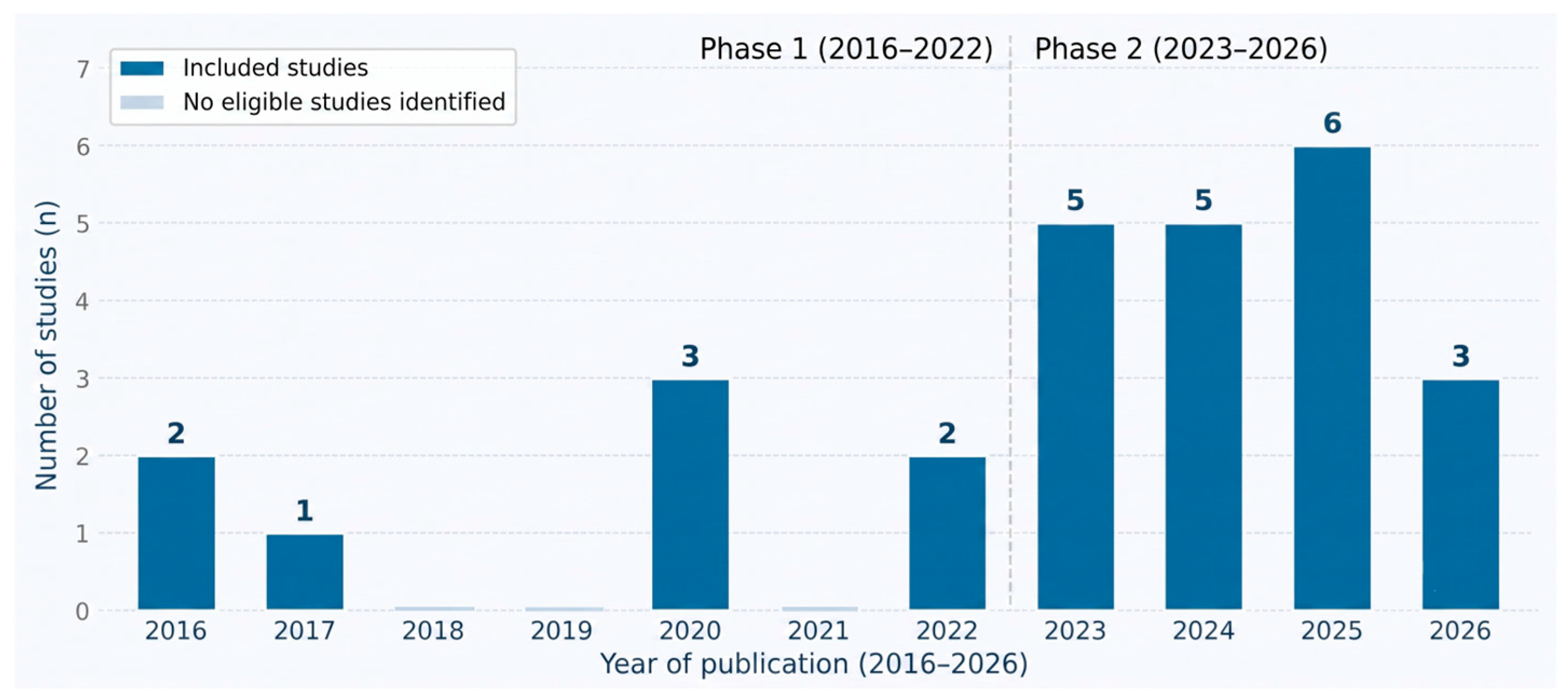
A temporal and geographic analysis of the selected studies reveals a decade-long evolution in how the academic community has engaged with spatial planning for coastal hazard mitigation, with publication activity spanning from 2016 to 2026 and showing marked acceleration in the most recent period. When examined through a temporal lens, the distribution of scholarly output reveals two distinct phases: a prolonged period of modest but steady engagement (2016–2022), followed by a sharp and significant acceleration (2023–2026) (Figure 2).
During the first phase (2016–2022), annual publication output remained relatively stable but low. Of these, there were only eight studies published that met the inclusion criteria during the 7-year period (2016–2022) with no studies published in 2018, 2019, or 2021. The largest output occurred during the year 2016 (two studies) and 2020 (three studies) during this period. This pattern is consistent with the broader trajectory of coastal resilience research, which for much of the past decade remained largely siloed within disciplines such as hydrology, urban planning, and environmental policy, without fully converging into a unified spatial planning discourse.
The second phase (2023–2026) accounts for 19 of the 27 included studies (70.4%). Publication momentum increased substantially during this period: five studies in 2023, five studies in 2024, six studies in 2025 and three in 2026. The dramatic rise is indicative of a growing momentum in scholarly interest in formalizing the components of a spatial planning approach for coastal hazard mitigation. Escalating frequency and severity of hazards related to climate, increasing policy focus to implement commitments in the post-Sendai Framework, and the realization that spatial planning, involving an approach positioned to intervene before development, is a critical governance tool to prevent entrenchment of vulnerable assets in high-risk coastal areas, are among the convergent factors that account for this trend. Regarding journal quality, 13 of 27 studies (48.1%) are published in journals ranked in the top one quarter (Q1), while 18 of 27 (66.7%) are published in journals ranked in the top two quarters (Q1 + Q2), which suggests that they are published in high-quality peer-reviewed outlets. The temporal acceleration reflects a paradigm shift in coastal resilience research and approaches, from reactive disaster (ad hoc) response to anticipatory territorial governance, integrating disaster risk into long-term development planning.
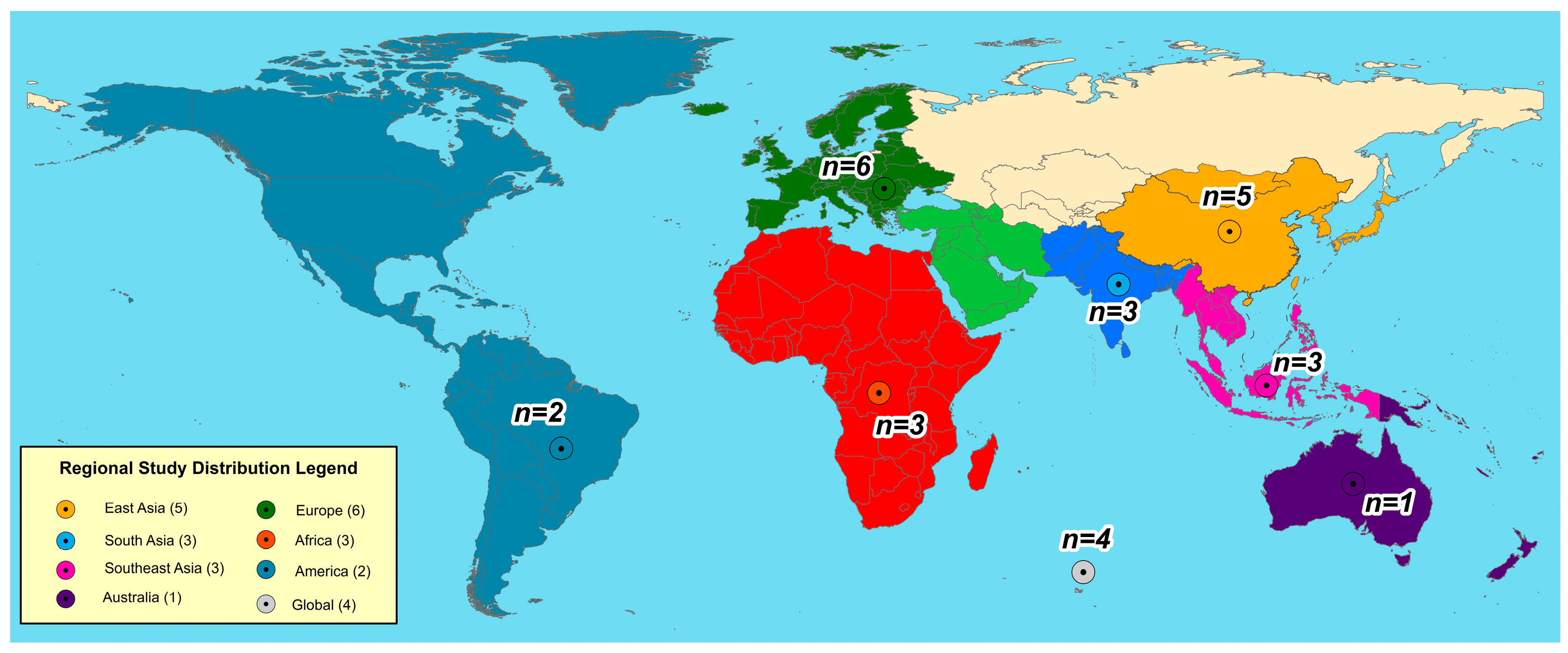
The selected studies encompass eight geographic regions, a much wider geographic scope than has previously been included in a systematic review in this field (Figure 3). The studies focusing on East Asia are the most represented among the Asian region with five studies (18.5%), led by China [42,43,44,46]. The Southeast Asian region is represented by three studies (Philippines [28,56] and Brunei [48]) and South Asia is represented by three studies (India [25,30] and Pakistan [25]). When combined with one study from Australia [49], Asian and Oceanian contexts account for twelve studies (44.4%). Of the rest, European countries provide six studies (22.2%) mainly from Italy [21,22,29,50], Greece [51] and Portugal [52]. Africa is represented by three studies (Egypt [24], Tanzania [53], and Mauritius [32]), and America contributes two studies (11.1%) from the United States [27] and Brazil [47]. Two studies (7.4%) take a global, multi-country/primarily conceptual approach [23,54,55,57].
The geographic clustering of research in Europe and the Asia–Pacific stems from superior institutional capacity and coastal risk urgency. Conversely, the underrepresentation of Africa and South America points to critical research gaps, despite these regions hosting the most climate-vulnerable coastal communities.

3.2. Coastal Hazard Typologies and the Effectiveness of Mitigation Approaches

3.2.1. Coastal Hazard Typologies

The coastal hazards addressed across the selected studies are classified into four categories based on their temporal dynamics and physical mechanisms, as summarized in Table 3. Hazards are not always restricted to a single type, and individual studies are often concerned with hazards from more than one hazard type as it is a composite risk in a coastal context.
Category A (Slow-Onset Climate and Hydro-Geological Processes, 11 studies) address hazards with long lead times, or hazards that lead to permanent land-use change, before they reach their critical limits. Land subsidence is most pronounced, for example, in Alexandria, Egypt, where it has exceeded the level of eustatic sea-level rise by a considerable margin, fundamentally changing risk characteristics, and ultimately limiting NbS mitigation strategies.
Category B: Acute Hydro-Meteorological Events (12 studies) focuses on events that are intense, sudden and happen within a short period of time. Of the hazards in this group, the hazard most frequently observed in various locations like Shenzhen, Norfolk, Mauritius and the Philippines, is storm surge.
Category C (Multi-Risk and Systemic Hazard Interactions, seven studies) regards hazard as being a complex system such that the influence of the combined hazard is more than the combined influence of each hazard. A methodological edge in this analysis is the probabilistic interaction matrices or even a double-exposure framework that takes into consideration the simultaneous susceptibility to climate change and economic globalization.
Category D (Ecological and Environmental Degradation, eight studies) acts as a standalone hazard and a multiplier of other vulnerabilities. The loss of natural buffer systems like mangroves, coastal forests, and dune vegetation removes the essential functions of wave attenuation, shoreline stabilization, and sediment regulations that coastal societies rely upon.

3.2.2. Spatial Planning Mitigation Strategies Documented in the Literature

Across the 27 reviewed studies, mitigation strategies are organized into three groups based on their primary operative logic: (1) technical and geospatial instruments; (2) NbS and ecosystem integration; and (3) governance, participatory, and institutional instruments. These groups are not mutually exclusive, as many studies combine strategies from more than one group. Table 4 provides a comparative overview; key findings from each group are discussed below.
Strategy Group 1: Technical and Geospatial Instruments. The 14 studies in this group generated planning-relevant outputs through GIS analysis and hazard modeling. Key examples include DESYCO for climate risk assessment in Mediterranean coastal zones [21], a combined Coastal Erosion and Flood Risk Index for the Greek coastline [51], and a source–pathway–receptor–consequence framework assessing ecosystem services at risk under extreme SLR in Italy [50]. Monitoring applications include shoreline change analysis in Queensland [49] and DSAS-based assessment of shoreline retreat in the Indus Delta [25]. The Alexandria case further shows that where land subsidence is the dominant driver, geospatial assessment must be supported by governance interventions [24].
Strategy Group 2: Nature-Based Solutions and Ecosystem Integration. Ten studies examine ecological systems as planning tools for risk reduction. A national assessment of Brazil’s coastline identifies mangroves, saltmarshes, coral reefs, and beach–dune systems as the primary adaptation strategy against SLR-related flooding and erosion [47]. In China, marine spatial planning enabled beach nourishment and ecological restoration that market mechanisms alone would not support. Vulnerability-based spatial models help position NbS before infrastructure development occurs [44]. Community participation is critical to mangrove restoration success in the Philippines [28], while weak enforcement limits NbS effectiveness in Taiwan despite supportive policy frameworks [45].
Strategy Group 3: Governance, Participatory, and Institutional Instruments. Ten studies identify governance arrangements and stakeholder engagement as key mechanisms for coastal hazard mitigation. In Italy, NbS mainstreaming progressed only when financial support was paired with institutional capacity-building [29], while global evidence shows that UNFCCC-funded adaptation projects often prioritize physical infrastructure over planning and governance capacity [54]. In Manila, fragmented metropolitan governance constrains integrated multi-hazard planning despite available resources [56]. Studies from Tanzania [53] and the Himalayan foothills [57] highlight the role of community livelihoods and local resource systems as informal resilience mechanisms where formal planning is weak. For small coastal states, blue urbanism frameworks propose integrated land–sea governance as an effective response to escalating SLR pressures [48].

3.2.3. Reported Effectiveness and Implementation Outcomes

This review distinguishes two forms of effectiveness evidence. Projected effectiveness refers to risk-reduction estimates derived from modeled scenarios, simulations, or cost–benefit analysis (CBA) projections. Implemented effectiveness refers to empirically measured reductions in vulnerability or exposure following real-world implementation. Effectiveness evidence across selected studies is predominantly projected, based on modeled future scenarios, or descriptive, documenting current conditions and governance processes. No study in the sample provides empirical before-and-after measurement of vulnerability reduction following actual implementation of an integrated spatial planning framework. This observation is reported here as a factual characteristic of the evidence base; its analytical significance is discussed in Section 4.3.2.
Among studies providing quantitative effectiveness findings, all of which report projected rather than implemented effectiveness, Luan et al. [46] demonstrate through MIKE 21 simulation that coastal land reclamation in Shenzhen creates a nonlinear amplification of storm surge inundation, with storm surge risk growing disproportionately relative to reclaimed areas, carrying significant implications for urban land-use decisions. Pais-Barbosa et al. [52] show through CBA modeling that beach nourishment at Ovar, Portugal, is cost-effective over a 30- to 50-year horizon when ecosystem service co-benefits are included, but that standard 4- to 5-year political planning cycles render this effectiveness economically invisible to decision-makers. Ruckelshaus et al. [55] document that InVEST and satellite-based data technologies improve the spatial precision of NbS risk assessments, enabling more targeted placement of coastal habitat relative to hazard exposure. Wang et al. [44] demonstrate that NbS pre-adopted in new urban development areas achieve significantly greater risk reduction relative to NbS retrofitted after infrastructure is established, quantifying the value of anticipatory integration.
Research on governance effectiveness demonstrates that institutional factors, rather than technical complexity, are the main reason planning initiatives successfully lead to actual risk reduction. Carlone and Mannocchi [29] find that NbS adoption in Emilia-Romagna increased measurably only where financial support was paired with institutional capacity-building. Van Onselen et al. [45] find that most Eco-DRR strategies formally endorsed under Taiwan’s Coastal Zone Management Act remain unimplemented. Kuhl et al. [54] find that UNFCCC-financed projects disproportionately fund physical infrastructure rather than planning capacity. Marquez and Olavides [28] find that mangrove projects with high community governance participation demonstrate significantly higher survival rates. Within this group, Carlone and Mannocchi [29] and Marquez and Olavides [28] provide the closest approximation to implemented effectiveness, reporting empirically measured or process-based reductions rather than modeled projections.
Implementation barriers documented across the selected studies are classified in Table 5.
Institutional barriers represent the most widespread constraint category, identified in 17 of 27 studies. Issues such as jurisdictional fragmentation, unenforceable planning, conflicting mandates, and the omission of NbS from formal instruments are frequently cited. This evidence confirms that governance architecture rather than technical deficiency remains the primary bottleneck. Ecological barriers (eight studies) and social–political barriers (eight studies) represent the next most widespread constraint categories, with the equity exclusion of marginalized communities documented across both high- and low-capacity governance settings.

3.3. Modes of Spatial Planning Integration with Coastal Hazard Mitigation

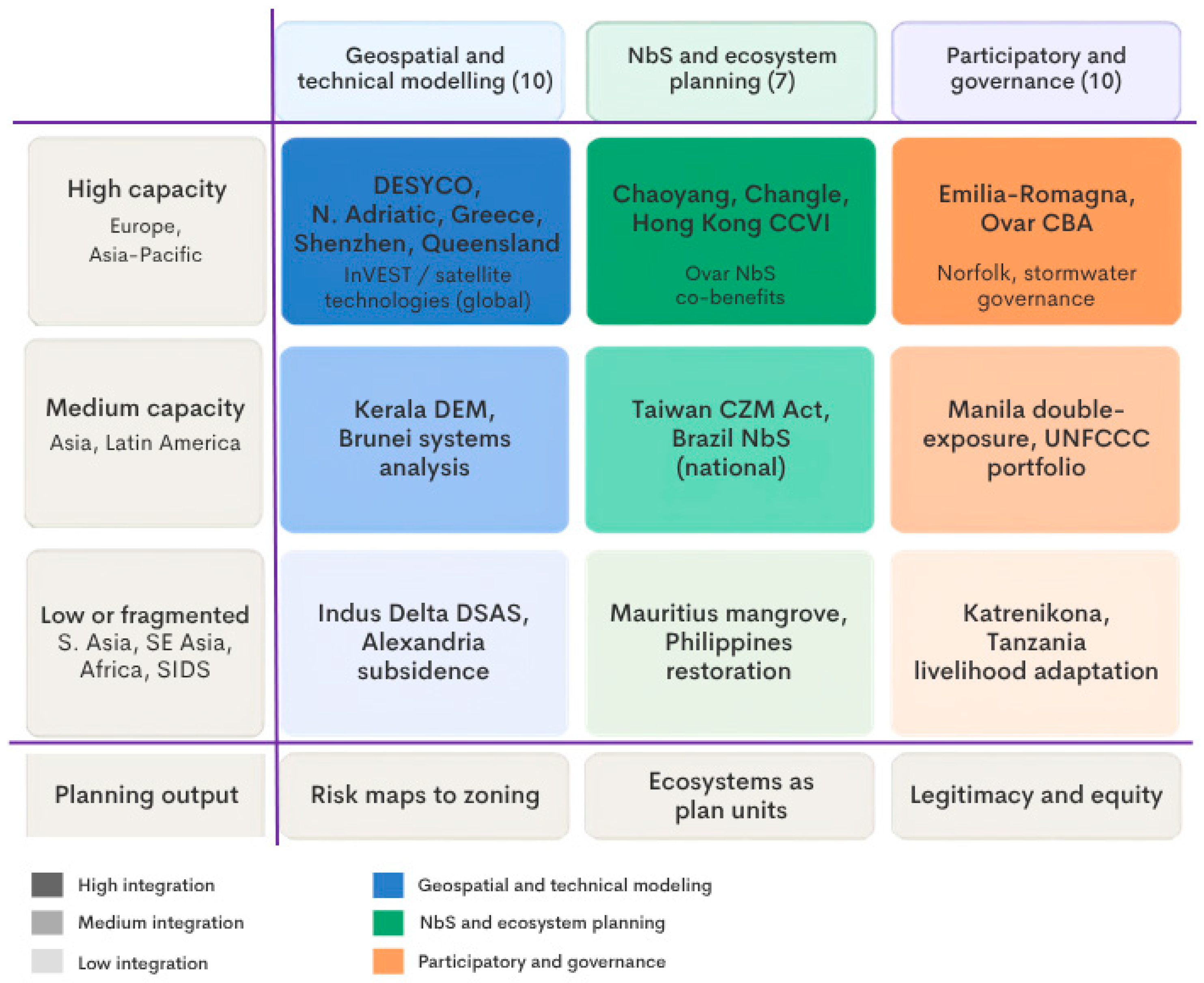
The selected studies integrate spatial planning with coastal hazard mitigation through three analytically distinct families, identified inductively from the evidence base: (1) geospatial and technical modeling integration, comprising 10 studies that use spatial data analysis and quantitative simulation to produce planning-actionable risk outputs; (2) NbS and ecosystem-planning integration, comprising seven studies that embed ecological systems as formal instruments within spatial planning frameworks; and (3) participatory, governance, and institutional integration, comprising 10 studies that position governance design and stakeholder engagement as the primary integration mechanism. These families differ in their epistemological basis, data and capacity requirements, and geographic distribution across the evidence base, but share the common objective of translating coastal hazard knowledge into spatially bounded planning decisions. The distribution across governance capacity contexts is mapped in Figure 4; the three families are compared across their data and technical thresholds, resource requirements, applicable governance scenarios, and principal limitations in Table 6 and the primary integration-path assignment of all 27 studies is provided in Supplementary Materials S4.

3.3.1. Geospatial and Technical Modeling Integration

Ten studies integrate spatial planning with hazard mitigation through spatial data analysis, GIS-based simulation, and quantitative modeling, producing outputs that directly inform land-use decisions, zoning designations, and emergency planning. This family is characterized by high data requirements and technical capacity dependence, with a predominantly European and Asia–Pacific geographic distribution.
Torresan et al. [21] present DESYCO as a GIS-MCDA platform integrating multiple climate-related hazards within a Regional Risk Assessment methodology for ICZM contexts, advancing from single-hazard mapping toward a cross-sectoral risk framework addressing physical, ecological, and socio-economic receptors simultaneously. Gallina et al. [22] build on this with an influence matrix approach quantifying probabilistic interactions among hazards, enabling planners to design spatial interventions for hazard combinations rather than individual events. Chalazas et al. [51] construct a dual-index framework for the entire Greek coastline using harmonized open-access European datasets, producing the first nationally consistent geospatial planning baseline for Greek ICZM. Furlan et al. [50] extend the source–pathway–receptor framework to incorporate ecosystem services as planning receptors, modeling service loss under extreme SLR scenarios to 2050 for the Italian Adriatic coast.
Monitoring-oriented studies generate multi-decadal spatial baselines: Durap [49] applies DSAS shoreline analysis across 90 Queensland transects over 38 years; Irfan et al. [25] deploy Landsat-DSAS modeling for the Indus Delta; Luan et al. [46] employ MIKE 21 to quantify the nonlinear relationship between land reclamation and storm surge inundation depth in Shenzhen; and Praveen and Kunnampalli [30] use DEM-based inundation modeling for SLR impact assessment in Kerala. Ruckelshaus et al. [55] document how open data technologies including InVEST, satellite telemetry, and machine learning are reducing data barriers in lower-capacity contexts. Boretti [24] demonstrates that where subsidence dominates the hazard profile, multi-pronged structural governance responses are required beyond what spatial risk assessment alone can deliver.
Geospatial integration is most effective when it operates across multiple hazard types simultaneously, incorporates temporal dynamics of both climate change and urban growth, and produces institutionally actionable outputs that can be directly used by institutions. This reflects an evolution from static vulnerability mapping toward temporally dynamic, multi-risk, governance-linked models that characterize the maturing methodology within this family.

3.3.2. Nature-Based Solutions and Ecosystem-Planning Integration

Seven studies integrate spatial planning with hazard mitigation by deploying or restoring ecological systems as functional planning instruments, producing prescriptions for ecosystem management action rather than risk maps.
The most advanced NbS integration in the evidence base occurs in China’s regulatory governance context. Liu S. et al. [42] demonstrate that marine spatial planning frameworks and regulatory mandates enabled beach nourishment and ecological restoration at Changle Airport Beach, a high-energy dissipative coast where market-driven governance would not have incentivized such investment. Liu S. et al. [43] examine hybrid NbS on the morphologically complex Chaoyang Port Coast, where policy frameworks favor combined hard engineering and ecological restoration over singular strategies. Wang et al. [44] design a Comprehensive Coastal Vulnerability Index and spatial decay model for pre-adoption application in new urban development areas—the most anticipatory form of NbS-planning integration in the evidence base. At the national scale, Manes et al. [47] document that coastal ecosystems including mangroves, saltmarshes, coral reefs, and beach–dune systems are the primary adaptation strategy for Brazil’s 8500 km coastline against SLR-driven flooding and erosion. Van Onselen et al. [45] assessed Eco-DRR implementation in Taiwan, finding a persistent gap between policy endorsement and enforcement capacity. At community scale, Marquez and Olavides [28] find community participation in project governance to be the decisive factor differentiating successful from failed mangrove restoration in the Philippines. Sunkur [32] reviews mangrove storm surge attenuation, wave energy reduction, and shoreline stabilization roles across the Mascarene Islands.
NbS achieves measurably higher effectiveness when integration is policy-mandated and institutionally enforced [42,44,45] compared with implementation for biodiversity or donor-driven goals without explicit climate mandates [32,47]; community governance participation is a documented predictor of NbS longevity in lower-capacity contexts [28,53].

3.3.3. Participatory, Governance, and Institutional Integration

Ten studies integrate spatial planning with coastal hazard mitigation primarily through governance architecture, institutional design, and stakeholder engagement. This family is the most geographically diverse in the evidence base spanning Europe, Asia, Africa, North America, and Latin America and it shows the highest level of attention to the social, political, and equity dimensions of planning integration.
Carlone and Mannocchi [29] evaluate NbS mainstreaming in Emilia-Romagna under EU H2020 OPERANDUM, finding that adoption into regional planning frameworks increased in municipalities where financial support was accompanied by governance training, inter-agency coordination, and stakeholder consultation process design, but not in municipalities receiving financial transfers alone. Grigg [23] documents the evolution of stormwater governance from singular drainage engineering toward multi-sectoral frameworks addressing ecology, water quality, and urban livability co-benefits across neighborhood-to-metropolitan scales. Kuhl et al. [54] find that UNFCCC-financed coastal adaptation projects systematically prioritize physical infrastructure investment over planning capacity, institutional development, and community-based adaptation. Pais-Barbosa et al. [52] demonstrate how participatory CBA integrating economic valuation and stakeholder engagement over 2020–2100-time horizons produce governance-legitimate adaptation investment decisions. Dakey et al. [26] show that ICZM can be mainstreamed into community governance in Katrenikona, India, by formalizing the ecological knowledge, livelihood practices, and resource management rules that coastal communities already apply. Ismael et al. [27] document that formal flood protection planning in Norfolk systematically excludes low-income coastal neighborhoods despite their disproportionate flooding exposure. Meerow [56] demonstrates that Manila’s decentralized metropolitan governance creates jurisdictional fragmentation preventing coordinated multi-hazard infrastructure planning even where financial resources and technical knowledge are available. Nautiyal et al. [57] document community livelihood diversification and collective resource stewardship as primary resilience mechanisms where formal planning systems are absent. Yanda et al. [53] find that marine and coastal resource endowments constitute the foundational resilience infrastructure for Tanzania’s Rufiji District communities, operating outside formal spatial planning systems. Yong et al. [48] present blue urbanism as a governance reframing that integrates land and sea as a unified governance domain for Brunei under compounding SLR and rainfall pressures.
Governance integration is the most contextual of the three families: in high-capacity contexts with legal enforcement, it generates durable planning outcomes including formalized adaptation pathways and documented risk equity improvements [23,29,52]. In lower-capacity contexts, community-based institutions emerge as the primary integration level [26,53,57]. The equity exclusion of marginalized communities is documented across both high- and low-capacity settings [27,54,56], confirming that socio-spatial equity in hazard planning is a cross-regional challenge.

3.4. Synthesis of Cross-Cutting Constructs Across the Evidence Base

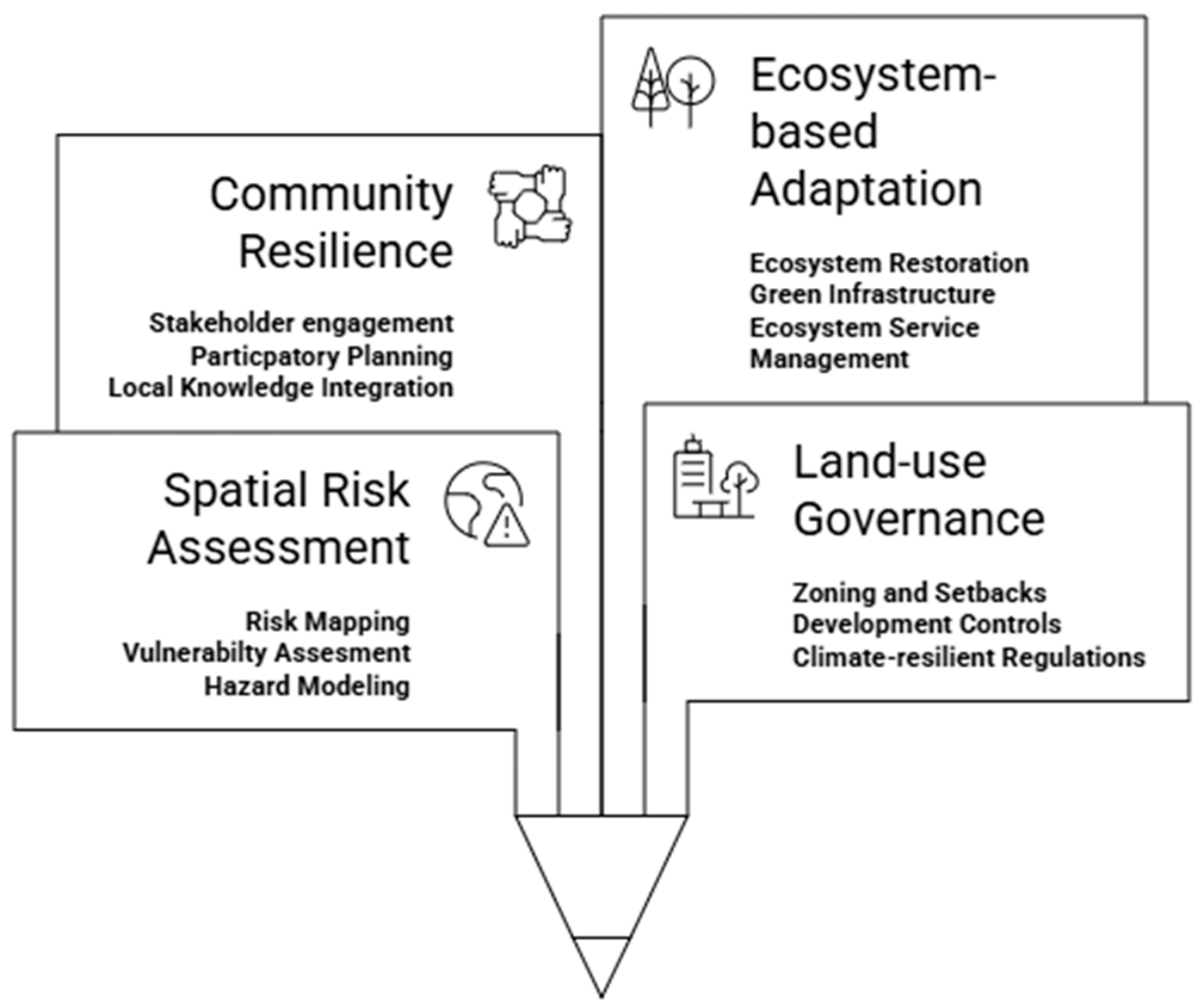
Across the 27 included studies, despite their diversity in geographic context, hazard typology, and planning tradition, four constructs emerge with sufficient consistency and analytical force to constitute organizing principles for coastal hazard mitigation integration (Figure 5). These constructs are reported here as descriptive finding patterns inductively identified from the evidence base rather than as prescriptive elements of a formal framework. They represent the common analytical threads linking disparate case studies and planning approaches, and they form the foundation upon which a more integrated theoretical model is developed.

3.4.1. Spatial Risk Assessment and Geospatial Modeling

Spatial risk assessment and geospatial modeling appear across the evidence base as the epistemic foundation for all planning interventions. Whether operationalized through GIS-based multi-risk mapping, satellite-derived vulnerability indices, hydrodynamic simulation, or DEM-based inundation modeling, the capacity to represent hazard, exposure, and vulnerability in spatial terms is documented across 18 studies as a prerequisite for planning action. The sophistication and scope of risk assessment vary dramatically from static present-day mapping in resource-constrained contexts to temporally dynamic, multi-hazard, scenario-based models in higher-capacity settings yet the function remains constant: to produce spatially explicit knowledge that can inform land-use decisions and emergency planning.

3.4.2. Land-Use Governance and Climate-Proof Planning Instruments

Land-use governance and climate-proof planning instruments emerge as the mechanism through which risk knowledge is translated into enforceable spatial regulations and development controls. This construct encompasses zoning ordinances, setback requirements, density restrictions, building code upgrades, managed retreat policies, and development refusal mechanisms all documented across the evidence base as mechanisms for reducing exposure. The institutional capacity to formalize and enforce these instruments varies substantially, from legally binding national frameworks in Europe and China to informal community-based rules in lower-capacity contexts, yet the strategic function is consistent: to regulate where development occurs relative to hazard exposure.

3.4.3. Community-Based Resilience and Participatory Governance Processes

Community-based resilience and participatory governance processes recur across 15 studies as the social dimension of planning integration. Whether through formal multi-stakeholder consultation processes, participatory risk assessment methods, co-production of adaptation strategies, or integration of Indigenous ecological knowledge into planning design, studies consistently document that hazard mitigation outcomes are mediated by the legitimacy, inclusivity, and responsiveness of governance processes. The effectiveness of participatory engagement in producing implemented vulnerability reduction varies; some studies document high-level participation producing no policy change, while others document community-driven governance generating locally grounded resilience practices, yet the analytical importance of governance processes themselves is ubiquitous.

3.4.4. Ecosystem-Based Adaptation and Nature-Based Solutions

Ecosystem-based adaptation and NbS function as a cross-cutting element spanning all three preceding constructs. Documented across 16 studies as deployed or restored ecological systems serving formal planning risk-reduction functions, ecosystem-based approaches enrich risk assessment by incorporating biophysical variables into spatial models, strengthen governance by providing concrete infrastructure objectives for planning instruments, and deepen community resilience through local environmental stewardship and livelihood co-benefits. While the strategic integration of ecosystem services into formal planning frameworks remains inconsistent with many measures motivated by biodiversity rather than explicit climate adaptation objectives their documented presence as a distinct mitigation category across diverse geographic and governance contexts establishes ecosystem-based adaptation as a fundamental planning element.
These four constructs—spatial risk assessment, land-use governance, community resilience, and ecosystem-based adaptation—do not operate as independent domains but as interconnected dimensions of a single complex system. Their interaction, the factors that enhance or constrain their effectiveness in different contexts, and the institutional and technical conditions required for their simultaneous operation form the analytical focus of Section 4.
Their emergence from the descriptive evidence base represents the synthetic outcome of the quantitative mapping (Section 3.1), thematic analysis (Section 3.2), and inductive pattern identification (Section 3.3) conducted across this review. Their interaction, and the conditions enabling or constraining them, form the analytical focus of Section 4.
Taken together, the results establish four empirical facts that frame the discussion: publication activity is accelerating but geographically concentrated; coastal hazards cluster into four typologies that rarely occur in isolation; spatial planning is integrated with mitigation through three distinct but overlapping families; and institutional barriers, not technical ones, dominate the reported constraints on implementation. The following section interprets these findings, examining the empirical grounding of the four-pillar framework, the moderating role of governance capacity, and the gaps that remain.

4. Discussion

The findings of this systematic review coalesce around a four-pillar framework comprising spatial risk assessment and geospatial modeling, land-use governance and climate-proof planning, community-based resilience and participatory governance, and ecosystem-based adaptation and NbS, a framework that recurs inductively across 27 empirically diverse studies. The discussion proceeds in three stages. Section 4.1 assesses the empirical grounding, implementation mechanisms, and internal tensions of this framework against the evidence base. Section 4.2 examines how governance capacity and data availability moderate framework applicability across contrasting planning contexts, with particular attention given to equity implications. Section 4.3 identifies evidence gaps and proposes a prioritized future research agenda aligned with the methodological and geographic limitations documented in the review.

4.1. Empirical Assessment of the Integrative Framework

4.1.1. Empirical Grounding of the Four-Pillar Framework

A central concern is whether the four-pillar framework is empirically grounded in the included studies or merely a normative overlay. The evidence supports the former interpretation. Spatial risk assessment appears across 18 of the 27 studies as a prerequisite for planning action, operationalized through GIS-based multi-hazard indices [21,22], satellite-derived vulnerability models [25,49], hydrodynamic simulation [46] and DEM-based inundation mapping [30]. Land-use governance is foregrounded in 15 studies, spanning legally binding coastal zone management frameworks in Europe and China [22,43,51] to community-based regulatory arrangements in India and Tanzania [26,53]. Community-based resilience and participatory processes recur across 15 studies as the mechanism through which planning decisions acquire social legitimacy and adaptive capacity [26,27,28,53], while ecosystem-based adaptation is documented in 16 studies as a concrete spatial planning instrument for reducing coastal risk [28,32,42,45,47,52].
Critically, however, the four pillars do not appear with equal frequency or as a coherent integrated system. Full four-pillar integration, meaning the simultaneous operationalization of all four functions within a single planning framework, is the exception rather than the rule: of the 27 studies, eight operationalize a single pillar, five operationalize two, 10 operationalize three, and only four achieve all four [27,51,52,53]. The complete classification across the four pillars is provided in the Supplementary Materials S5. The strongest coupling is between spatial risk assessment and ecosystem-based adaptation, documented in studies from Hong Kong [44], Greece [51], Brazil [47] and Taiwan [45], where vulnerability indices explicitly incorporate biophysical variables as spatial planning inputs. Governance–ecosystem linkages appear in the mainstream literature from Emilia-Romagna [29] and in the Eco-DRR policy assessments from Taiwan [45] and the Philippines [28]. The weakest coupling is between quantitative spatial risk tools and community-based resilience: social and spatial strands remain largely parallel across the evidence base rather than genuinely integrated within single operational frameworks.
This empirical pattern has theoretical implications. Rather than representing four independent best-practice domains assembled by normative preference, the pillars appear to reflect structurally interdependent dimensions of a shared socio-ecological planning problem: hazard exposure that is spatially differentiated (necessitating risk assessment), governance arrangements that determine whether risk knowledge shapes regulations (necessitating land-use governance), social processes that determine legitimacy and adaptive capacity (necessitating community engagement), and ecological systems that function simultaneously as risk-reduction infrastructure and planning substrates (necessitating ecosystem-based approaches). The recurrence of this structure across contexts as diverse as Manila, Alexandria, the Indus Delta, and Emilia-Romagna supports interpreting the framework as an emergent explanatory model rather than an ideal-type prescription.

4.1.2. Implementation Mechanism

Understanding why integrated coastal hazard mitigation succeeds or fails in practice requires moving from the identification of pillars to the mechanisms through which they interact. The evidence base reveals four distinct conversion pathways. First, spatial risk outputs function as prioritization logics for planning action: multi-risk frameworks such as DESYCO [21] and the North Adriatic influence matrix [22] generate ranked hotspot maps that planning authorities use to set adaptation priorities and designate zones for coastal zone management. The Hong Kong CCVI [44] demonstrates the most anticipatory form of this pathway, integrating NbS siting into new urban development masterplans before infrastructure is committed, achieving a meaningful reduction in vulnerability relative to baseline urbanization scenarios. Second, land-use governance converts risk information into enforceable spatial regulations, but only where legal and institutional frameworks permit it. Portugal’s participatory cost–benefit analysis at Ovar [52] illustrates how risk knowledge is translated into legitimate investment decisions across 30- to 50-year time horizons through the coupling of morphodynamic modeling with ecosystem service valuation and stakeholder engagement. Third, participatory processes anchor technical designs within local knowledge and livelihood realities, as demonstrated by community preference elicitation in Katrenikona, India [26], and hybrid knowledge co-production in Philippine mangrove restoration [28]. Fourth, ecosystem-based adaptation functions simultaneously as physical risk reduction infrastructure and as spatial planning grammar. National-scale evidence from Brazil shows that the presence of coastal habitats substantially reduces coastal risk relative to areas where such ecosystems have been degraded or removed [47], while new data technologies increasingly enable the mainstreaming of these functions into policy and investment calculus [55].
These four mechanisms do not operate sequentially; they interact through positive feedback and failure cascades. A virtuous cycle is documented in studies where risk analytics enable NbS valuation, which strengthens governance legitimacy for NbS procurement, which in turn creates demand for more refined spatial analytics [44,55]. A failure cascade is documented in contexts where governance fragmentation prevents risk information from reaching zoning decisions [56], where NbS are adopted without ecological or institutional support [45], or where participatory outputs are generated but not acted upon by formal governance bodies [26,27]. The implication for planning theory is that the framework should not be read as a sequential model of assessing, then planning, then engaging, then restoring, but rather as a system of mutually enabling and potentially undermining processes whose integration must be actively managed.

4.1.3. Planning Trade-Offs and Tensions Between Pillars

A further empirical finding with significant implications for framework applicability is that the four pillars regularly generate competing demands on available land, resources, and institutional capacity rather than converging into additive resilience. The most pervasive conflict is between development pressure and ecosystem protection, documented across Mauritius [32], Emilia-Romagna [29], Taiwan [45], and Shenzhen [46]. In Shenzhen, hydrodynamic simulation demonstrates that coastal land reclamation creates nonlinear amplification of storm surge risk, with reclaimed area growth producing disproportionate inundation depth, yet this finding has not reversed the trajectory of urban expansion, illustrating the political economy of risk entrenchment [46]. In Emilia-Romagna, agricultural, navigational, and tourism interests resist renaturation and dune conservation despite documented NbS effectiveness, and the absence of technical standards for NbS gives risk-averse officials cover to default to conventional grey infrastructure [29].
A second structural tension separates technocratic planning, which is privileged by risk assessment frameworks requiring data, expertise, and computational infrastructure, from community-based governance, which prioritizes local knowledge, participatory legitimacy, and socio-ecological co-production. Alappuzha, Kerala [30] and Manila [56] both illustrate contexts where technically sophisticated risk analyses coexist with marginalized communities whose exposure profiles remain unaddressed by formal planning. In Manila, decentralized metropolitan governance produces jurisdictional fragmentation that prevents coordinated multi-hazard infrastructure planning even when financial resources and risk knowledge are available [56]. Norfolk, Virginia [27], extends this pattern to a high-capacity Global North setting, documenting that formal flood protection planning systematically excludes low-income coastal neighborhoods despite their disproportionate flooding vulnerability, confirming that socio-spatial equity in hazard planning is a cross-regional challenge rather than a development-context-specific problem.
A third dimension of tension exists between the intrinsic span of time of political cycle and financial cycle and that of adaptation span for effective coastal risk management. The Ovar case [52] proves that the cost effectiveness still holds over a 30–50-year planning period if ecosystem service co-benefits are internalized, but that typical political cycle lengths of 4–5 years make the cost effectiveness economically invisible for decision makers. In the Alexandria case [24] the land subsidence resultant from groundwater exploitation and compaction of the delta is taking place at rates significantly higher than the eustatic sea-level rise, and governance action is currently still framed around the episodic disaster event rather than the steady multi-decadal hazard trajectory. These findings collectively support a reformulation of the framework not as a static model to be applied uniformly, but as a governance challenge requiring the active management of competing temporal, spatial, and political logics through deliberate institutional design.

4.2. Contextual Transferability: Governance Capacity and Data Availability as Moderators

4.2.1. Governance Capacity as the Primary Moderator

The evidence base reveals a consistent and analytically significant pattern concerning the conditions under which planning interventions translate into durable risk reduction. Governance capacity, as operationalised in Section 2.4.2, is a stronger predictor of coastal hazard mitigation outcomes across all four pillars than the sophistication of the tools or strategies employed. In high-capacity settings, sophisticated multi-hazard risk tools are embedded in multilevel institutional architectures, NbS are mainstreamed through statutory land-use instruments, and participatory processes generate binding adaptation pathways. In lower-capacity settings, even well-designed risk assessments and NbS prescriptions frequently stall at the implementation stage due to institutional fragmentation, absent legal standards, and episodic project-based financing.
This moderating function of governance capacity is documented across all four pillars. For spatial risk assessment, European cases including DESYCO [21] and the North Adriatic multi-risk framework [22] demonstrate that high-capacity governance can embed spatial tools within ICZM planning mandates and coastal zone management authorities, enabling risk outputs to inform zoning and development controls. By contrast, in the Indus Delta [25] and Kerala [30], comparable analytical frameworks based on Landsat-DSAS modeling and DEM-based inundation mapping are generated without commensurate governance uptake, producing spatially precise risk knowledge that remains disconnected from land-use regulation. For land-use governance, Chinese regulatory mandates demonstrate that policy-driven NbS procurement can outperform market-driven or voluntary implementation even on technically challenging coasts [42,43], while Brazil’s national-scale analysis documents that strong biophysical evidence for ecosystem protection is insufficient to reverse legal weakening of coastal habitat protections [47]. For community-based resilience, Philippine mangrove projects confirm that community participation in governance design is the decisive factor differentiating successful from failed restoration: projects with hybrid local–scientific knowledge integration achieved significantly higher survival rates and longer maintenance commitments [28]. For ecosystem-based adaptation, Taiwan’s Eco-DRR experience documents that formal statutory recognition of ecosystem-based approaches in the Coastal Zone Management Act is insufficient without enforcement mechanisms and budget allocation, while mangrove planting in the absence of ecological compatibility assessment produced maladaptive outcomes including invasive species and dune oversteepening requiring remediation [45].
The cross-study implication is that governance capacity should be treated not as a contextual given but as itself a target of planning intervention. Evidence from Emilia-Romagna [29] is particularly instructive: NbS adoption increased measurably in municipalities where financial support was accompanied by governance training, inter-agency coordination, and stakeholder consultation process design, but not in municipalities receiving financial transfers alone. The UNFCCC portfolio analysis [54] reinforces this finding at global scale: project design systematically prioritizes physical infrastructure investment over planning capacity and institutional development, and the evidence base suggests that this represents a structural misallocation of adaptation finance relative to the actual determinants of sustained risk reduction.

4.2.2. Data Availability and Emerging Technologies as Enabling and Moderating Factors

Across the evidence base, data availability and emerging geospatial technologies function as enabling and moderating factors for the spatial risk assessment pillar rather than as autonomous transformative drivers of coastal resilience. The clearest demonstration of the enabling function is the documented reduction in technical and cost barriers to spatial risk assessment in lower-capacity contexts through open-access satellite data and semi-automated tools: Landsat and DSAS analysis of the Indus Delta [25], spatiotemporal shoreline vulnerability assessment across 90 Queensland transects [49], and InVEST-based ecosystem service quantification [55] all demonstrate that long-term, spatially resolved risk knowledge can be generated without dense in situ monitoring infrastructure.
However, the evidence also documents consistent limits on the transformative potential of technology in the absence of governance reform. In Emilia-Romagna [29], legal uncertainty about NbS standards and risk-averse institutional cultures prevent data-rich pilot projects from scaling into mainstream practice. In Manila [56], advanced infrastructure planning frameworks coexist with governance fragmentation that prevents coordinated multi-hazard responses. In small island and SIDS contexts [32], poor planning and development in hazard zones have eliminated natural buffers, creating risk conditions that data technologies subsequently attempt to map but cannot remediate retroactively. Several contributors explicitly caution that an overemphasis on early-warning systems and observational technologies in global adaptation portfolios can bias finance toward technocentric, short-term disaster risk management and away from broader adaptive capacity building [54]. The implication for framework applicability is that the spatial risk pillar should be calibrated to the data context by deploying open, scalable tools in lower-capacity settings, while remaining cognizant that risk information, however precise, creates governance demands that cannot be satisfied by technology alone.

4.2.3. Implications for Framework Transferability and Planning Equity

The geographic concentration of the evidence base creates an asymmetry in the empirical foundation of the four-pillar framework. Of the studies included, 66.7% originate from Europe and Asia–Pacific, while Africa, Latin America, and small island developing states are substantially underrepresented. Full four-pillar integration, where all pillars are simultaneously advanced within a coherent institutional architecture, is primarily documented in higher-capacity planning contexts. In lower-capacity settings, the pillars appear in more fragmentary configurations: community-based resilience and locally led ecosystem initiatives are often the most feasible entry points [26,28,53], while integrated spatial assessment and formal land-use governance reform require longer institutional investment trajectories.
This finding has direct implications for how the framework should be applied across governance contexts. Rather than treating all four pillars as equally operationalizable everywhere, a contextually adaptive application would sequence and weight them according to existing institutional strengths.
A critical equity dimension of transferability concerns not only what is feasible, but whose risk is prioritized. The evidence documents equity exclusion as a cross-regional phenomenon: marginalized communities face disproportionate hazard exposure regardless of whether governance capacity is high (Norfolk [27]; Manila [56]) or low (Katrenikona [26]; Rufiji District [53]). Importing high-capacity planning models without adapting participation mechanisms, legal safeguards, and financing structures to local conditions risks entrenching unequal protection and prioritizing technically tractable ‘ready-to-go’ interventions at the expense of community-centered resilience building. A contextually equitable application of the framework would therefore treat the empowerment of vulnerable communities in planning decision-making as a first-order governance objective rather than a supplementary consultation exercise.

4.3. Evidence-Based Gaps and Future Research Directions

4.3.1. Structural Limitations of the Current Evidence Base

Despite documenting 27 studies that collectively advance understanding of spatial planning integration for coastal hazard mitigation, the evidence base reveals three categories of structural limitation that constrain theory development and practical application. First, effectiveness evidence is predominantly projected or process-based rather than implemented: no included study provides empirical before-and-after measurement of vulnerability reduction following actual implementation of an integrated spatial planning framework. Quantitative findings are drawn from modeled scenarios [44,46], cost–benefit projections [52], and comparative design simulations [55] rather than from longitudinal monitoring of implemented interventions. This creates a significant gap between documented planning integration and demonstrated risk reduction, limiting the capacity of the framework to guide evidence-based policy.
Second, methodological limitations constrain theory-building on compound risk, adaptive pathways, and institutional path-dependence. Multi-risk tools such as DESYCO [21] and the North Adriatic influence matrix [22] are explicitly positioned as semi-quantitative screening instruments emphasizing flexibility over rigor in joint probability and threshold dynamics. While this pragmatic positioning is appropriate for planning support, it limits the development of formal theories of cascading hazard interactions. Longitudinal shoreline and delta assessments [25,49] document multi-decadal physical trends without linking them to governance trajectories or social vulnerability outcomes. NbS effectiveness is primarily assessed through conceptual or modeled risk reduction [45,47] rather than systematic post-implementation monitoring.
Third, geographic and sectoral biases in the evidence base reflect structural inequities in research funding, academic publishing access, and institutional capacity. Six of the 27 studies originate from European contexts with well-established planning systems, while Africa is represented by three studies, Latin America by one, and small island developing states by one. This distributional imbalance means that the framework’s empirical grounding is disproportionately derived from contexts with mature planning infrastructure, and the evidence on full four-pillar integration in the most climate-vulnerable settings remains insufficient to support confident transferability claims.

4.3.2. Priority Future Research Directions

Four priority research directions follow directly from the three structural limitations identified in Section 4.3.1. The absence of implemented effectiveness evidence motivates the first; the methodological constraints on compound-risk and implementation analysis motivate the second and third; and the geographic concentration of the evidence base motivates the fourth. Each is selected because it addresses a documented gap rather than an aspirational extension of the field.
The most critical and urgent need is for longitudinal comparative studies that track social–ecological vulnerability before and after integrated framework implementation. Such studies should be designed as panel or cohort analyses, following coastal municipalities or delta communities through sequences of interventions that combine hard infrastructure, NbS, and hybrid approaches, measuring hazard exposure, ecosystem condition, governance quality, and community well-being outcomes over decadal time horizons. These designs are particularly necessary in lower-capacity governance contexts, where demonstrating real risk reduction can justify the institutional investments required for more integrated four-pillar planning. The staged adoption of decision-support systems such as DESYCO across different planning jurisdictions creates a natural experiment opportunity for step-wedge study designs, where jurisdictions adopting tools at different times can be compared on subsequent land-use decisions and observed risk outcomes.
A second priority is the governance-embedded evaluation of NbS and Eco-DRR implementation across different institutional contexts. The evidence base documents numerous cases of NbS policy design and planning integration, but systematic comparisons of implementation outcomes across governance regimes remain absent. Specifically, research is needed that examines how legal standards, liability frameworks, and financing logics shape the scaling of NbS from pilot projects to mainstream practice, a question identified as theoretically unresolved in Emilia-Romagna [29] and Taiwan [45]. Combining global portfolio analyses of adaptation finance [54] with in-depth implementation evaluations, explicitly comparing the outcomes of policy-planning investments versus on-the-ground measures, would allow for more rigorous assessment of where adaptation finance produces the greatest risk reduction per unit of expenditure.
Third, fully socio-ecological risk metrics are needed to operationalize the integration of adaptive capacity, livelihoods, equity, and accessibility dimensions into existing spatial risk indices. The current evidence base documents repeated calls for such integration [22,51] alongside the analytical tools of community preference elicitation [26] and human–nature interaction frameworks that could provide the social indicators, yet these developments remain parallel rather than integrated within applied planning tools. Future research should extend existing GIS-based vulnerability frameworks to incorporate community-level indicators derived from co-production processes and deploy new data technologies not only to quantify physical risk reduction but to monitor governance and social outcomes of integrated interventions [55].
Fourth, the transferability of community-based governance models documented primarily in coastal India [21] and the Philippines [28] to other institutional and cultural settings, particularly in Africa, requires systematic empirical investigation. These models should be tested not as importable templates but as adaptable frameworks whose core logic of hybrid knowledge co-production, livelihood–ecosystem co-governance, and locally anchored institutional support must be renegotiated with each community context. Connecting these models to regional multi-risk planning and national adaptation strategies represents a critical bridge between the community-based resilience pillar and the formal governance instruments of the other three pillars, and its absence is one of the most consequential gaps in the current evidence base.
Because these four directions differ in their data and institutional prerequisites, they are best pursued sequentially, aligned with the governance capacity tiers of the Contextual Feasibility Taxonomy (Table 7), rather than simultaneously. In the near term, the two evaluation-intensive directions are most feasible in high-capacity, coordinated statutory systems such as Europe and East Asia, where mature monitoring infrastructure supports longitudinal and step-wedge designs (Direction 1) and governance-embedded evaluation of NbS and Eco-DRR implementation (Direction 2). In the medium term, high-resource but institutionally fragmented systems, such as Manila, Norfolk and Alexandria, provide appropriate environments for implementing integrated socio-ecological risk metrics (Direction 3), as these locations already possess technical capacity and physical risk data, which now need to be complemented by social, equity and livelihood indicators. Priority investment, however, should be directed first toward lower-capacity, community-governed settings, particularly across sub-Saharan Africa and small island developing states, where transferability testing of community-based governance models (Direction 4) addresses the largest evidence gap and the greatest exposure; this direction warrants funding first despite being the most methodologically demanding, so that empirical support for four-pillar integration accumulates where it is most consequential rather than only where it is easier to obtain.

4.3.3. Theoretical Contribution and Practical Significance

This review makes three contributions to theory and practice. Theoretically, it advances beyond prior systematic reviews by demonstrating that spatial planning for coastal hazard mitigation is not a collection of parallel instrumental domains but an integrated governance challenge requiring simultaneous attention to risk knowledge production, regulatory design, participatory legitimacy, and ecological infrastructure. The four-pillar framework operationalizes this integration as a set of interdependent planning functions, maps the conditions under which they reinforce or undermine each other, and situates governance capacity as the primary moderating variable that determines whether technical and ecological innovations translate into durable risk reduction. Methodologically, the framework’s inductive development from a globally diverse evidence base, and its systematic mapping against implementation outcomes and context variables, responds directly to the gap between normative planning frameworks and empirically grounded explanatory models, a gap highlighted in this review and in the wider literature surveyed here.
Practically, the framework provides coastal planners and adaptation practitioners with a diagnostic instrument for assessing the configuration of planning capacities in their specific contexts, identifying which pillars are operationally feasible, where institutional reforms are prerequisites for progress, and how to sequence investment across governance scales. The contextual feasibility taxonomy presented in Table 7 operationalizes this diagnostic function by sequencing the four pillars according to the governance capacity context, identifying which pillar functions as the most feasible entry point, which requires longer institutional investment, and what reform is the binding prerequisite for fuller integration—providing a planning tool explicitly designed for application across the full diversity of coastal governance contexts rather than only in the well-resourced settings that dominate the evidence base. Most significantly, by challenging the systematic exclusion of marginalized communities from hazard governance processes across both high- and low-capacity settings, the framework positions coastal spatial planning not merely as a technical risk management enterprise but as a governance process with profound implications for social justice in the face of escalating climate change.

5. Conclusions

This systematic review, conducted in accordance with the PRISMA 2020 guidelines, synthesized 27 peer-reviewed studies drawn from an initial pool of 368 records to examine how spatial planning frameworks are mobilized for coastal hazard mitigation. Regarding RQ1, the review revealed a pronounced acceleration in scholarly output after 2022, with 19 of the 27 included studies (70.4%) published during 2023–2026. The evidence base remains geographically concentrated in Asia–Pacific and Europe, whereas Africa and small island developing states (SIDSs) are critically underrepresented despite being among the regions most exposed to coastal hazards. This imbalance limits the transferability of current planning knowledge and highlights the need for broader geographical representation in future research.
With respect to RQ2, the review identified four broad categories of coastal hazards: slow-onset climate and hydro-geological processes, acute hydro-meteorological events, multi-risk systemic interactions, and ecological and environmental degradation. These hazards are addressed through distinct yet complementary mitigation approaches, although evidence of effectiveness remains largely projected rather than implemented. Regarding RQ3, three principal pathways through which spatial planning is integrated with coastal hazard mitigation emerged from the reviewed literature: geospatial and technical modeling, nature-based solutions and ecosystem-planning integration, and participatory governance and institutional integration. Although these approaches differ in their methodological orientation and implementation requirements, the findings consistently demonstrate that governance capacity, rather than technical sophistication alone, is the primary determinant of successful implementation. Institutional fragmentation, weak regulatory enforcement, and inadequate inter-agency coordination remain the most frequently reported barriers, whereas even relatively simple planning instruments can achieve meaningful outcomes when supported by coherent governance arrangements.
Finally, addressing RQ4, the review synthesized four interdependent constructs that together constitute an integrative analytical framework for coastal hazard mitigation: spatial risk assessment and geospatial modeling, land-use governance and climate-proof planning, community-based resilience and participatory governance, and ecosystem-based adaptation and nature-based solutions. Rather than functioning independently, these constructs reinforce one another within a socio-ecological planning system in which effective hazard mitigation depends on the coordinated integration of scientific knowledge, regulatory instruments, participatory governance, and ecosystem-based strategies. Across all governance contexts, socio-spatial equity emerged as a persistent cross-cutting challenge, with vulnerable communities experiencing disproportionate exposure to coastal risks.
Taken together, these findings indicate that advancing coastal hazard mitigation requires reframing spatial planning not as a universal sequence of technical or ecological best practices, but as a governance challenge requiring context-sensitive implementation. The review further demonstrates that planning priorities should differ according to governance capacity. In high-capacity planning systems, strengthening community participation, equity considerations, and cross-sectoral integration within existing statutory planning frameworks should be prioritized. In technically capable but institutionally fragmented contexts, improving inter-agency coordination and regulatory implementation represents the most pressing need. In lower-capacity regions, particularly along underdeveloped African coastlines and in small island developing states, community-based resilience and ecosystem-based adaptation provide practical and cost-effective entry points, while progressively strengthening spatial risk assessment and land-use governance capacities over time. Nevertheless, the geographic concentration of existing evidence in high-capacity planning systems and the limited availability of post-implementation effectiveness studies remain important limitations of the current literature. Future research should therefore prioritize longitudinal evaluation of planning outcomes and examine the transferability of integrated spatial planning frameworks to lower-capacity and highly climate-vulnerable coastal settings, particularly in Africa and SIDSs.

Supplementary Materials

The following supporting information can be downloaded at: https://www.mdpi.com/article/10.3390/su18178648/s1.

Author Contributions

Conceptualization, M.M.H.M., M.Z.S.B. and E.M.Q.; methodology, M.M.H.M. and M.Z.S.B.; validation, M.M.H.M. and M.Z.S.B.; formal analysis, M.Z.S.B.; investigation, M.Z.S.B.; resources, M.Z.S.B.; data curation, M.Z.S.B.; writing—original draft preparation, M.Z.S.B.; writing—review and editing, M.M.H.M., M.Z.S.B. and E.M.Q.; visualization, M.Z.S.B., M.M.H.M. and E.M.Q. All authors have read and agreed to the published version of the manuscript.

Funding

The project was funded by KAU Endowment (WAQF) at King Abdulaziz University, Jeddah, Saudi Arabia. The authors, therefore, acknowledge with thanks WAQF and the Deanship of Scientific Research (DSR) for technical and financial support.

Institutional Review Board Statement

Not applicable.

Informed Consent Statement

Not applicable.

Data Availability Statement

No new data were created or analyzed in this study. Data sharing is not applicable to this article.

Acknowledgments

The authors would like to express their gratitude and acknowledgment for The Scientific Endowment (WAQF) at King Abdulaziz University, Jeddah Saudi Arabia for their continues support. During the preparation of this manuscript/study, the authors used Napkin AI for the purposes of creating the 4 Pillar figure. The authors have reviewed and edited the output and take full responsibility for the content of this publication.

Conflicts of Interest

The authors declare no conflicts of interest.

Abbreviations

The following abbreviations are used in this manuscript:
CBACost–benefit analysis
CCAClimate change adaptation
CCVIComprehensive Coastal Vulnerability Index
DEMDigital Elevation Model
DESYCOThe DEcision support SYstem for COastal climate change impact assessment
DSASDigital Shoreline Analysis System
DRRDisaster Risk Reduction
EbAEcosystem-based Adaptation
Eco-DRREcosystem-based Disaster Risk Reduction
GCCGulf Cooperation Council
GISGeographic Information System
ICZMIntegrated Coastal Zone Management
InVESTIntegrated Valuation of Ecosystem Services and Trade-Offs
IPCCIntergovernmental Panel on Climate Change
MSLMean Sea Level
NbSNature-based Solutions
NDVINormalized Difference Vegetation Index
NDSSINormalized Difference Suspended Sediment Index
PRISMAPreferred Reporting Items for Systematic Reviews and Meta-Analyses
SIDSsSmall Island Developing States
SLRSea-level rise
UNFCCCUnited Nations Framework Convention on Climate Change
WoSWeb of Science

References

  1. Griggs, G.; Reguero, B.G. Coastal Adaptation to Climate Change and Sea-Level Rise. Water 2021, 13, 2151. [Google Scholar] [CrossRef] [Scilit]
  2. Toimil, A.; Losada, I.J.; Nicholls, R.J.; Dalrymple, R.A.; Stive, M.J.F. Addressing the Challenges of Climate Change Risks and Adaptation in Coastal Areas: A Review. Coast. Eng. 2020, 156, 103611. [Google Scholar] [CrossRef] [Scilit]
  3. Neumann, B.; Vafeidis, A.T.; Zimmermann, J.; Nicholls, R.J. Future Coastal Population Growth and Exposure to Sea-Level Rise and Coastal Flooding: A Global Assessment. PLoS ONE 2015, 10, e0118571. [Google Scholar] [CrossRef] [Scilit] [PubMed]
  4. Monioudi, I.N.; Vousdoukas, M.I.; Giardino, A.; Stocchino, A.; Mentaschi, L.; Feyen, L. Impacts of Sea Level Rise and Adaptation across Asia and the Pacific. Sci. Rep. 2025, 15, 35742. [Google Scholar] [CrossRef] [Scilit] [PubMed]
  5. Hauer, M.E.; Hardy, R.D.; Kulp, S.A.; Mueller, V.; Wrathall, D.; Clark, P.U. Assessing Population Exposure to Coastal Flooding Due to Sea Level Rise. Nat. Commun. 2021, 12, 6900. [Google Scholar] [CrossRef] [Scilit] [PubMed]
  6. Schernewski, G.; Konrad, A.; Roskothen, J.; von Thenen, M. Coastal Adaptation to Climate Change and Sea Level Rise: Ecosystem Service Assessments in Spatial and Sectoral Planning. Appl. Sci. 2023, 13, 2623. [Google Scholar] [CrossRef] [Scilit]
  7. Sarkissian, R.; Sayah, M.; Abdallah, C.; Zaninetti, J.; Nedjai, R. Land Use Planning to Reduce Flood Risk: Opportunities, Challenges and Uncertainties in Developing Countries. Sensors 2022, 22, 6957. [Google Scholar] [CrossRef] [Scilit] [PubMed]
  8. Farinós-Dasí, J.; Pinazo-Dallenbach, P.; Sánchez-Manjavacas, E.; Rodríguez-Bernal, D. Disaster Risk Management, Climate Change Adaptation and the Role of Spatial and Urban Planning: Evidence from European Case Studies. Nat. Hazards 2024, 121, 23479–23512. [Google Scholar] [CrossRef] [Scilit]
  9. Barua, U.; Ansary, M.; Islam, I.; Munawar, H.; Mojtahedi, M. Multi-Criteria Earthquake Risk Sensitivity Mapping at the Local Level for Sustainable Risk-Sensitive Land Use Planning. Sustainability 2023, 15, 7518. [Google Scholar] [CrossRef] [Scilit]
  10. Tiar, P.; Ricki, G.; Pradizzia, T. Disaster Risk Reduction through the Reform of Spatial Structure and Land Use Planning in Banda Aceh City. IOP Conf. Ser. Earth Environ. Sci. 2021, 916, 12027. [Google Scholar] [CrossRef] [Scilit]
  11. Kato, S.; Huang, W. Land Use Management Recommendations for Reducing the Risk of Downstream Flooding Based on a Land Use Change Analysis and the Concept of Ecosystem-Based Disaster Risk Reduction. J. Environ. Manag. 2021, 287, 112341. [Google Scholar] [CrossRef] [Scilit] [PubMed]
  12. Zhang, Z.; Tyc, J.; Hensel, M. An Ecogeomorphological Approach to Land-Use Planning and Natural Hazard Risk Mitigation: A Literature Review. Land 2025, 14, 1911. [Google Scholar] [CrossRef] [Scilit]
  13. Spaliviero, M.; Boerboom, L.; Gibert, M.; Spaliviero, G.; Bajaj, M. The Spatial Development Framework to Facilitate Urban Management in Countries with Weak Planning Systems. Int. Plan. Stud. 2019, 24, 235–254. [Google Scholar] [CrossRef] [Scilit]
  14. Attah, R.; Garba, B.; Gil-Ozoudeh, I.; Iwuanyanwu, O. Leveraging Geographic Information Systems and Data Analytics for Enhanced Public Sector Decision-Making and Urban Planning. Magna Sci. Adv. Res. Rev. 2024, 12, 152–163. [Google Scholar] [CrossRef] [Scilit]
  15. Delphin, S.; Snyder, K.; Tanner, S.; Musalem, K.; Marsh, S.; Soto, J. Obstacles to the Development of Integrated Land-Use Planning in Developing Countries: The Case of Paraguay. Land 2022, 11, 1339. [Google Scholar] [CrossRef] [Scilit]
  16. Rauws, W.; De Roo, G. Adaptive Planning: Generating Conditions for Urban Adaptability. Lessons from Dutch Organic Development Strategies. Environ. Plan. B Plan. Des. 2016, 43, 1052–1074. [Google Scholar] [CrossRef] [Scilit]
  17. Davar, L.; Griggs, G.; Danehkar, A.; Salmanmahiny, A.; Azarnivand, H.; Naimi, B. A Spatial Integrated SLR Adaptive Management Plan Framework (SISAMP) toward Sustainable Coasts. Water 2021, 13, 2263. [Google Scholar] [CrossRef] [Scilit]
  18. Sajjad, M.; Chan, J. Risk Assessment for the Sustainability of Coastal Communities: A Preliminary Study. Sci. Total Environ. 2019, 671, 339–350. [Google Scholar] [CrossRef] [Scilit] [PubMed]
  19. Yu, H.; Zhang, F.; Yu, H.; Li, Y. A Multi-Criteria Framework for Sustainable Marine Spatial Planning in Coastal Cities: Case Study in Shenzhen, China. Sustainability 2025, 10, 4480. [Google Scholar] [CrossRef] [Scilit]
  20. Kennish, M. Management Strategies to Mitigate Anthropogenic Impacts in Estuarine and Coastal Marine Environments: A Review. Open J. Ecol. 2022, 12, 667–688. [Google Scholar] [CrossRef]
  21. Torresan, S.; Critto, A.; Rizzi, J.; Zabeo, A.; Furlan, E.; Marcomini, A. DESYCO: A Decision Support System for the Regional Risk Assessment of Climate Change Impacts in Coastal Zones. Ocean Coast. Manag. 2016, 120, 49–63. [Google Scholar] [CrossRef] [Scilit]
  22. Gallina, V.; Torresan, S.; Zabeo, A.; Critto, A.; Glade, T.; Marcomini, A. A Multi-Risk Methodology for the Assessment of Climate Change Impacts in Coastal Zones. Sustainability 2020, 12, 3697. [Google Scholar] [CrossRef] [Scilit]
  23. Grigg, N.S. Stormwater Management: An Integrated Approach to Support Healthy, Livable, and Ecological Cities. Urban Sci. 2024, 8, 89. [Google Scholar] [CrossRef] [Scilit]
  24. Boretti, A. Prioritizing Subsidence Mitigation in Alexandria, Egypt: A Multi-Pronged Approach beyond Nature-Based Solutions. Mediterr. Geosci. Rev. 2025, 7, 447–456. [Google Scholar] [CrossRef] [Scilit]
  25. Irfan, M.; Farrukh, S.; Khan, H.A.; Mahmud, S.; Nasir, B.; Idrees, M. Spatiotemporal Modelling of Coastal Vulnerability and Ecosystem Degradation in Indus Delta: A Landsat and DSAS Approach. Mehran Univ. Res. J. Eng. Technol. 2025, 44, 209–221. [Google Scholar] [CrossRef] [Scilit]
  26. Dakey, S.; Joshi, S.; Sukhwani, V.; Deshkar, S. A Community-Based Approach to Mainstream Human-Nature Interactions into Coastal Risk Governance: A Case of Katrenikona, India. Geogr. Pannonica 2022, 26, 65–78. [Google Scholar] [CrossRef] [Scilit]
  27. Ismael, D.; Hutton, N.; Erten-Unal, M.; Considine, C.; Vandecar-Burdin, T.; Davis, C.; Chen, Y.-H. Community-Centric Approaches to Coastal Hazard Assessment and Management in Southside Norfolk, Virginia, USA. Atmosphere 2024, 15, 372. [Google Scholar] [CrossRef] [Scilit]
  28. Marquez, G.P.B.; Olavides, R.D. Integrating Science-Based and Local Ecological Knowledge: A Case Study of Mangrove Restoration and Rehabilitation Projects in the Philippines. Disasters 2024, 48, e12630. [Google Scholar] [CrossRef] [Scilit] [PubMed]
  29. Carlone, T.; Mannocchi, M. Overcoming Barriers and Fostering Adoption: Evaluating the Institutional Mainstreaming of Nature-Based Solutions in the Emilia-Romagna Region’s Socio-Ecological System. Land 2024, 13, 1175. [Google Scholar] [CrossRef] [Scilit]
  30. Praveen, D.; Kunnampalli, J. Evaluating the Impacts of Anticipated Sea Level Rise, Climate Change and Land Use Land Cover Scenarios on the Rice Crop in Alappuzha, Kerala and Strategies to Build Climate Responsive Agriculture. Int. J. Disaster Resil. Built Environ. 2024, 15, 755–775. [Google Scholar] [CrossRef] [Scilit]
  31. Almheiri, A.; Montenegro, J.; Ewane, E.; Mohan, M. Climate Change Hazards and the Resilience of Coastal Cities in the Gulf Cooperation Council Countries: A Systematic Review. City Environ. Interact. 2024, 24, 100177. [Google Scholar] [CrossRef] [Scilit]
  32. Sunkur, R.; Kantamaneni, K.; Bokhoree, C.; Ravan, S. Mangroves’ Role in Supporting Ecosystem-Based Techniques to Reduce Disaster Risk and Adapt to Climate Change: A Review. J. Sea Res. 2023, 196, 102449. [Google Scholar] [CrossRef] [Scilit]
  33. Quagliolo, C.; Roebeling, P.; Mendonça, R.; Pezzoli, A.; Comino, E. Integrating Biophysical and Economic Assessment: Review of Nature-Based Adaptation to Urban Flood Extremes. Urban Sci. 2022, 6, 53. [Google Scholar] [CrossRef] [Scilit]
  34. Wamsler, C.; Niven, L.; Beery, T.; Bramryd, T.; Ekelund, N.; Jönsson, I.; Osmani, A.; Palo, T.; Stålhammar, S. Operationalizing Ecosystem-Based Adaptation: Harnessing Ecosystem Services to Buffer Communities against Climate Change. Ecol. Soc. 2016, 21, 31. [Google Scholar] [CrossRef] [Scilit]
  35. Page, M.J.; McKenzie, J.E.; Bossuyt, P.M.; Boutron, I.; Hoffmann, T.C.; Mulrow, C.D.; Shamseer, L.; Tetzlaff, J.M.; Akl, E.A.; Brennan, S.E.; et al. The PRISMA 2020 Statement: An Updated Guideline for Reporting Systematic Reviews. BMJ 2021, 372, n71. [Google Scholar] [CrossRef] [Scilit] [PubMed]
  36. Moher, D.; Liberati, A.; Tetzlaff, J.; Altman, D.G. Preferred Reporting Items for Systematic Reviews and Meta-Analyses: The PRISMA Statement. PLoS Med. 2009, 6, e1000097. [Google Scholar] [CrossRef] [Scilit] [PubMed]
  37. Tranfield, D.; Denyer, D.; Smart, P. Towards a Methodology for Developing Evidence-Informed Management Knowledge by Means of Systematic Review. Br. J. Manag. 2003, 14, 207–222. [Google Scholar] [CrossRef] [Scilit]
  38. Kitchenham, B. Procedures for Performing Systematic Reviews. In Proceedings of the Keele University Technical Report; Keele University: Keele, UK, 2004; pp. 1–26. [Google Scholar]
  39. Xiao, Y.; Watson, M. Guidance on Conducting a Systematic Literature Review. J. Plan. Educ. Res. 2019, 39, 93–112. [Google Scholar] [CrossRef] [Scilit]
  40. Sauer, P.C.; Seuring, S. How to Conduct Systematic Literature Reviews in Management Research: A Guide in 6 Steps and 14 Decisions. Rev. Manag. Sci. 2023, 17, 2769–2801. [Google Scholar] [CrossRef] [Scilit]
  41. Harari, M.B.; Parola, H.R.; Hartwell, C.J.; Riegelman, A. Literature Searches in Systematic Reviews and Meta-Analyses: A Review, Evaluation, and Recommendations. J. Vocat. Behav. 2020, 118, 103377. [Google Scholar] [CrossRef] [Scilit]
  42. Liu, S.; Cai, F.; Rangel-Buitrago, N.; Peng, Y.; Wagreich, M.; Zhang, T.; Wang, P. Nature-Based Solutions for Coastal Restoration during Urbanization: Implications of a Case Study along Chaoyang Port Coast, China. Ocean Coast. Manag. 2025, 266, 107691. [Google Scholar] [CrossRef] [Scilit]
  43. Liu, S.; Yu, F.; Cai, F.; Lin, H.; Jiang, D.; Sitkiewicz, P.; He, Y.; Yin, H.; Wagreich, M.; Vilibić, I. Enhancing Coastal Resilience with Nature-Based Solutions: Policy-Driven Restoration of a High-Energy Beach (Changle Airport Beach, China). Ocean Coast. Manag. 2026, 273, 108031. [Google Scholar] [CrossRef] [Scilit]
  44. Wang, H.; Han, B.; Wu, T.; Leung, F.; Ren, Y. Pre-Adopting New Urban Areas to Climate Change with Coastal Nature-Based Solutions. Ecol. Indic. 2025, 177, 113693. [Google Scholar] [CrossRef] [Scilit]
  45. Van Onselen, V.; Bayrak, M.M.; Lin, T.-Y. Assessment of Ecosystem-Based Disaster Risk Reduction Strategies in Coastal Environments of Taiwan. J. Disaster Res. 2023, 18, 700. [Google Scholar] [CrossRef] [Scilit]
  46. Luan, B.; Ye, X.; Luo, J.; Xie, S.; Xia, C.; Ning, Y.; Zhu, M. Revealing the Relationship between Storm Surge Risks and Coastal Urbanization Characteristics under Sea Level Rise. Ecol. Indic. 2026, 183, 114626. [Google Scholar] [CrossRef] [Scilit]
  47. Manes, S.; Gama-Maia, D.; Vaz, S.; Pires, A.P.F.; Tardin, R.H.; Maricato, G.; Bezerra, D.D.S.; Vale, M.M. Nature as a Solution for Shoreline Protection against Coastal Risks Associated with Ongoing Sea-Level Rise. Ocean Coast. Manag. 2023, 235, 106487. [Google Scholar] [CrossRef] [Scilit]
  48. Yong, G.Y.V.; Azalie, I.A.; Hasharina Hassan, N. Blue Urbanism and Economy: A Strategy for the Future of Brunei. Southeast Asia Multidiscip. J. 2025, 25, 206–218. [Google Scholar] [CrossRef] [Scilit]
  49. Durap, A. Multi-Decadal Spatiotemporal Shoreline Vulnerability Assessment (1987–2025): Integrating Erosion-Accretion Dynamics for Disaster Risk Reduction across 90 Coastal Transects. Nat. Hazards 2025, 121, 22981–23019. [Google Scholar] [CrossRef] [Scilit]
  50. Furlan, E.; Derepasko, D.; Torresan, S.; Pham, H.V.; Fogarin, S.; Critto, A. Ecosystem Services at Risk in Italy from Coastal Inundation under Extreme Sea Level Scenarios up to 2050: A Spatially Resolved Approach Supporting Climate Change Adaptation. Integr. Environ. Assess. Manag. 2022, 18, 1564–1577. [Google Scholar] [CrossRef] [Scilit] [PubMed]
  51. Chalazas, T.; Chatzistratis, D.; Stamatiadou, V.; Monioudi, I.N.; Katsanevakis, S.; Velegrakis, A.F. Integrated Coastal Zone Management in the Face of Climate Change: A Geospatial Framework for Erosion and Flood Risk Assessment. Water 2026, 18, 284. [Google Scholar] [CrossRef] [Scilit]
  52. Pais-Barbosa, J.; Ferreira, A.M.; Lima, M.; Filho, L.M.; Roebeling, P.; Coelho, C. Cost-Benefit Analysis of Artificial Nourishments: Discussion of Climate Change Adaptation Pathways at Ovar (Aveiro, Portugal). Ocean Coast. Manag. 2023, 244, 106826. [Google Scholar] [CrossRef] [Scilit]
  53. Yanda, P.Z.; Mabhuye, E.B.; Mwajombe, A. Linking Coastal and Marine Resources Endowments and Climate Change Resilience of Tanzania Coastal Communities. Environ. Manag. 2023, 71, 15–28. [Google Scholar] [CrossRef] [Scilit] [PubMed]
  54. Kuhl, L.; Van Maanen, K.; Scyphers, S. An Analysis of UNFCCC-Financed Coastal Adaptation Projects: Assessing Patterns of Project Design and Contributions to Adaptive Capacity. World Dev. 2020, 127, 104748. [Google Scholar] [CrossRef] [Scilit]
  55. Ruckelshaus, M.; Reguero, B.G.; Arkema, K.; Compeán, R.G.; Weekes, K.; Bailey, A.; Silver, J. Harnessing New Data Technologies for Nature-Based Solutions in Assessing and Managing Risk in Coastal Zones. Int. J. Disaster Risk Reduct. 2020, 51, 101795. [Google Scholar] [CrossRef] [Scilit]
  56. Meerow, S. Double Exposure, Infrastructure Planning, and Urban Climate Resilience in Coastal Megacities: A Case Study of Manila. Environ. Plan. A 2017, 49, 2649–2672. [Google Scholar] [CrossRef] [Scilit]
  57. Nautiyal, S.; Schaldah, R.; Raju, K.V.; Kaechele, H.; Pritchard, B.; Rao, K.S. Climate Change Challenge (3C) and Social-Economic-Ecological Interface-Building—Exploring Potential Adaptation Strategies for Bio-Resource Conservation and Livelihood Development: Epilogue. In Environmental Science and Engineering; Springer: Berlin/Heidelberg, Germany, 2016. [Google Scholar] [CrossRef] [Scilit]
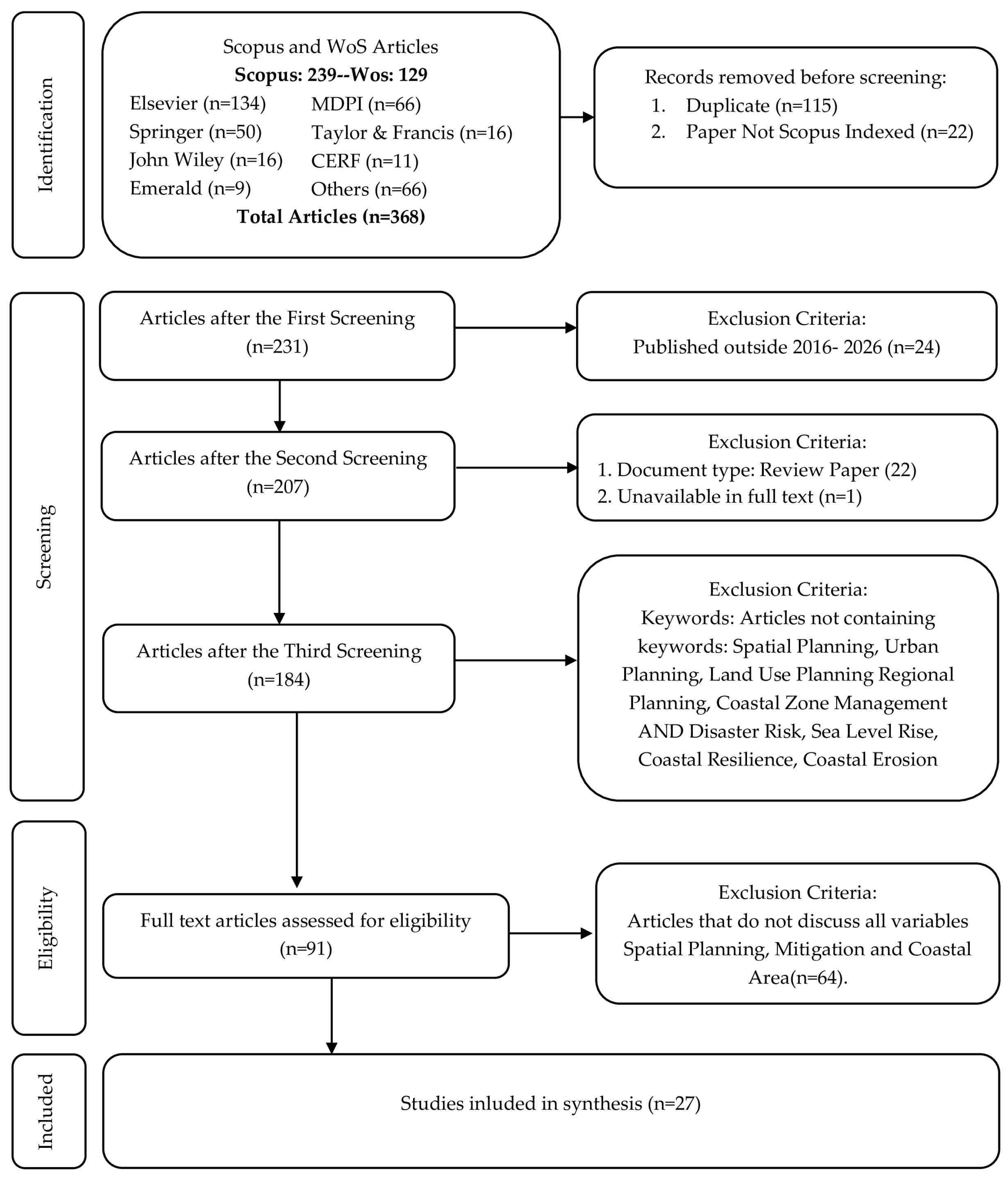
Figure 1. PRISMA 2020 flow diagram of the systematic review process.
Sustainability 18 08648 g001
Figure 2. Temporal distribution of selected studies by publication year (2016–2026).
Sustainability 18 08648 g002
Figure 3. Geographical distribution of selected studies.
Sustainability 18 08648 g003
Figure 4. Spatial planning integration families emerging from the reviewed studies. The three columns represent dominant integration families: geospatial and technical modelling, nature-based and ecosystem planning, and participatory governance. Rows correspond to institutional integration capacity contexts (high, medium, and low or fragmented). Color hue identifies the integration family, whereas color intensity indicates institutional integration strength, ranging from high (dark shades) to low or fragmented (light shades). The bottom row summarises the principal planning outputs typically associated with each integration family.
Sustainability 18 08648 g004
Figure 5. Four-pillar spatial planning framework for coastal hazard mitigation.
Sustainability 18 08648 g005
Table 1. Overview of the 27 studies included in the systematic review. The complete extracted dataset is available in the Supplementary Materials S3.
No.AuthorTitleCountryRef. No
1Torresan S. et al.DESYCO: A decision support system for the regional risk assessment of climate change impacts in coastal zonesItaly[21]
2Gallina V. et al.A multi-risk methodology for the assessment of climate change impacts in coastal zonesItaly[22]
3Grigg N.S.Stormwater Management: An Integrated Approach to Support Healthy, Livable, and Ecological CitiesMulty countries[23]
4Boretti A.Prioritizing subsidence mitigation in Alexandria, Egypt: a multi-pronged approach beyond nature-based solutionsEgypt[24]
5Irfan, M et al.Spatiotemporal Modelling of Coastal Vulnerability and Ecosystem Degradation in Indus Delta: A Landsat and DSAS ApproachPakistan[25]
6Dakey, S et al.A Community-based Approach to Mainstream Human-Nature Interactions into Coastal Risk Governance: A case of Katrenikona, IndiaIndia[26]
7Ismael D. et al.Community-Centric Approaches to Coastal Hazard Assessment and Management in Southside Norfolk, Virginia, USAUSA[27]
8Marquez G.P.B. et al.Integrating science-based and local ecological knowledge: a case study of mangrove restoration and rehabilitation projects in the PhilippinesPhilippines[28]
9Carlone T. et al.Overcoming Barriers and Fostering Adoption: Evaluating the Institutional Mainstreaming of Nature-Based Solutions in the Emilia-Romagna Region’s Socio-Ecological SystemItaly[29]
10Praveen D. et al.Evaluating the impacts of anticipated sea level rise, climate change and land use land cover scenarios on the rice crop in Alappuzha, Kerala and strategies to build climate responsive agricultureIndia[30]
11Sunkur R. et al.Mangroves’ role in supporting ecosystem-based techniques to reduce disaster risk and adapt to climate change: A reviewMauritius[32]
12Liu S. et al.Nature-based solutions for coastal restoration during urbanization: Implications of a case study along Chaoyang Port Coast, ChinaChina[42]
13Liu S. et al.Enhancing coastal resilience with nature-based solutions: Policy-driven restoration of a high-energy beach (Changle Airport Beach, China)China[43]
14Wang H. et al.Pre-adopting new urban areas to climate change with coastal Nature-based solutionsHong Kong[44]
15van Onselen V. et al.Assessment of Ecosystem-Based Disaster Risk Reduction Strategies in Coastal Environments of TaiwanTaiwan[45]
16Luan B. et al.Revealing the relationship between storm surge risks and coastal urbanization characteristics under sea level riseChina[46]
17Manes S. et al.Nature as a solution for shoreline protection against coastal risks associated with ongoing sea-level riseBrazil[47]
18Yong G.Y.V. et al.Blue urbanism and economy: a strategy for the future of BruneiBrunei[48]
19Durap A.Multi-decadal spatiotemporal shoreline vulnerability assessment (1987–2025): integrating erosion-accretion dynamics for disaster risk reduction across 90 coastal transectsAustralia[49]
20Furlan E. et al.Ecosystem services at risk in Italy from coastal inundation under extreme sea level scenarios up to 2050: A spatially resolved approach supporting climate change adaptationItaly[50]
21Chalazas T. et al.Integrated Coastal Zone Management in the Face of Climate Change: A Geospatial Framework for Erosion and Flood Risk AssessmentGreece[51]
22Pais-Barbosa J. et al.Cost-benefit analysis of artificial nourishments: Discussion of climate change adaptation pathways at Ovar (Aveiro, Portugal)Portugal[52]
23Yanda P.Z. et al.Linking Coastal and Marine Resources Endowments and Climate Change Resilience of Tanzania Coastal CommunitiesTanzania[53]
24Kuhl L. et al.An analysis of UNFCCC-financed coastal adaptation projects: Assessing patterns of project design and contributions to adaptive capacityMulty countries[54]
25Ruckelshaus M. et al.Harnessing new data technologies for nature-based solutions in assessing and managing risk in coastal zonesMulty countries[55]
26Meerow S.Double exposure, infrastructure planning, and urban climate resilience in coastal megacities: A case study of ManilaPhilippines[56]
27Nautiyal S. et al.Climate change challenge (3C) and social-economic-ecological interface-building—exploring potential adaptation strategies for bio-resource conservation and livelihood development: EpilogueMulty countries[57]
Table 2. Data Extraction Categories.
No.Extraction DomainVariables CapturedApplies toObjective Served
1.Bibliographic & contextualAuthors; year; title; journal & quartile; country/regionAll studiesObj 1
2.Coastal hazard characteristicsHazard type; metrics (return period, inundation depth, erosion rate); temporal & spatial scaleAll studiesObj 2
3.Spatial planning frameworkPlanning level (local–transboundary); instruments (zoning, shoreline management plans, ICZM, marine spatial plans); geospatial DSS (GIS, MCDA)All studiesObj 3
4.Mitigation strategies & outcomesEmbedded measures (setbacks, development restrictions, managed retreat, NbS); reported effects on exposure/vulnerability; quantitative risk-reduction outcomes Obj 2 & 3
5.Governance & implementationResponsible institutions; vertical & horizontal coordination; stakeholder participation; implementation barriersAll studiesObj 3 & 4
6.Ecosystem-based & nature-based componentsEcosystems (mangrove, wetland, dune, reef) as spatial planning units; role in Eco-DRR and NbSNbS/Eco-DRR studieObj 3 & 4
7.Study design & methodological featuresResearch design; primary data sources; methodological quality considerations by study typeAll studiesObj 1 & 4
Table 3. Typology of coastal hazards addressed across 27 included studies.
Hazard CategorynSpecific Hazard TypesKey Studies
A—Slow-Onset Climate and Hydro- Geological Processes11SLR and coastal inundation; coastal erosion and shoreline retreat; land subsidence; saltwater intrusion[24,25,30,42,44,45,47,49,50,51,52]
B—Acute Hydro-Meteorological Events12Storm surge; coastal and tidal flooding; stormwater and fluvial flooding; wind events[21,22,23,26,27,28,29,32,43,44,46,53]
C—Multi-Risk and Systemic Hazard Interactions7Compound multi-hazard exposure; probabilistic hazard interactions; double exposure to climate and globalization[22,48,54,55,56,57]
D—Ecological and Environmental Degradation8Mangrove and coastal forest loss; shoreline vegetation loss; sediment flux reduction; ecosystem services loss[25,28,32,42,43,45,49,50,53]
Table 4. Summary of spatial planning mitigation strategy groups identified across the reviewed literature (n = 27).
Strategy GroupPrimary InstrumentsKey Studies (n)
Technical & Geospatial (n = 14)GIS-based multi-criteria DSS; shoreline change modeling (DSAS, MIKE 21); DEM inundation; CVI/CFRI indices; InVEST/AI data platforms; CBA integrationTorresan [21] (Italy); Chalazas [51] (Greece); Furlan [50]; Durap [49] (Australia); Irfan [25] (Pakistan); Luan [46] (China); Praveen [30] (India); Pais-Barbosa [52] (Portugal); Boretti [24] (Egypt); Ruckelshaus [55] (global)
Nature-Based Solutions & Ecosystem Integration (n = 10)Hybrid NbS (hard + ecological); beach nourishment under MSP mandates; pre-adoption CVI-spatial decay siting; mangrove/saltmarsh/coral reef as primary adaptation; Eco-DRR frameworks; ecosystem CBA co-benefitsLiu S. [42,43] (China); Wang [44]; (China) Manes [47] (Brazil); Marquez [28] (Philippines); Sunkur [32] (Mauritius); Van Onselen [45] (Taiwan); Pais-Barbosa [52] (Portugal); Ruckelshaus [55] (global)
Governance, Participatory & Institutional (n = 10)NbS mainstreaming via capacity-building (H2020 OPERANDUM); UNFCCC project design reform; ICZM with community ecological knowledge; participatory CBA; blue urbanism & land–sea governance unification; decentralized metro coordinationCarlone [29] (Italy); Kuhl [54] (global); Dakey [26] (India); Ismael [27] (USA); Grigg [23] (global); Meerow [56] (Philippines); Nautiyal [57] (global); Pais-Barbosa [52] (Portugal); Yanda [53] (Tanzania); Yong [48] (Brunei)
Table 5. Implementation barrier taxonomy across the 27 included studies, showing frequency and dominant governance capacity context.
CategorySpecific BarrierKey Studies
Reporting
Capacity ContextCount%
TechnicalData unavailability/
modeling uncertainty
[22,24,25,30,49]Both518.5%
Absence of GIS or computational capacity[25,26,54,57]Low414.8%
InstitutionalJurisdictional fragmentation[23,29,48,54,56]High518.5%
Plans not legally enforceable[26,27,29,45]Both414.8%
Conflicting sectoral mandates[23,29,54,56]High414.8%
NbS absent from formal planning instruments[28,29,32,45]Both414.8%
Social/PoliticalParticipatory outputs not acted upon[26,27,53,57]Low414.8%
Equity exclusion of marginalized communities[26,27,54,56]Both414.8%
EconomicFinancing misaligned with planning capacity[29,52,54]Both311.1%
Short political cycles vs. long adaptation horizons[24,46,52]High311.1%
EcologicalNbS motivated by biodiversity, not climate adaptation[28,29,32,45]High414.8%
Degraded ecological baseline limits NbS effectiveness[24,25,28,32]Low414.8%
Table 6. Cross-path comparison of the three spatial planning integration families identified across the 27 included studies, summarizing data and technical thresholds, funding and resource requirements, applicable governance scenarios, documented advantages, principal limitations, and characteristic planning output. Representative cases are illustrative; the complete integration-path assignment of all 27 studies is given in the Supplementary Materials S4.
Comparison DimensionGeospatial & Technical Modeling (n = 10)NbS & Ecosystem Planning (n = 7)Participatory, Governance & Institutional (n = 10)
Data & technical thresholdHigh. Requires spatial datasets (DEM, satellite imagery), GIS-MCDA platforms, and hydrodynamic/inundation modeling; dependent on computational infrastructure and specialist expertise.Moderate. Requires ecological baseline and habitat data, vulnerability indices, and monitoring; less computationally intensive but constrained by ecological condition.Low technical threshold but high institutional and coordination demand; relies on governance design, stakeholder processes, and local knowledge rather than computation.
Funding/resource requirementCapital- and expertise-intensive: data acquisition, modeling software, and specialist analysts, typically embedded in research or agency programmes.Restoration and maintenance costs over long horizons; cost-effective across 30–50-year horizons when ecosystem co-benefits are internalized, but returns are invisible within 4–5-year political cycles.Investment in institutional capacity-building, inter-agency coordination, and sustained stakeholder engagement; financial transfers alone are insufficient without governance training.
Applicable governance scenarioHigh-capacity, data-rich systems with established planning frameworks (predominantly Europe and Asia–Pacific); most effective where technical outputs feed zoning and emergency planning.Contexts with regulatory mandates and enforcement capacity (China exemplar); also viable at community scale in lower-capacity settings with existing local stewardship.Most context-dependent: in high-capacity contexts with legal enforcement it yields durable formalized adaptation pathways; in low-capacity contexts community-based institutions become the primary integration level.
Documented advantagesSpatially explicit, multi-hazard, temporally dynamic risk outputs directly actionable for land-use and zoning decisions; enables anticipatory prioritization of hazard hotspots.Measurably higher risk reduction where policy-mandated and enforced; supports anticipatory (pre-adoption) siting; delivers ecological co-benefits; community governance predicts NbS longevity.Most geographically transferable; embeds social legitimacy and equity; effective across the full governance capacity spectrum; simple tools succeed when embedded in coordinated governance.
Key limitationsHigh data dependence limits transfer to low-capacity contexts; risk knowledge often fails to reach zoning where governance is fragmented; screening tools limit formal compound-risk theory.Persistent policy–implementation gap (endorsement without enforcement); frequently motivated by biodiversity rather than explicit climate adaptation; degraded ecological baselines reduce effectiveness.Participatory outputs frequently not acted upon by formal bodies; equity exclusion of marginalized communities across both high- and low-capacity settings; outcomes highly sensitive to institutional context.
Planning outputRisk maps translated into zoning designations.Ecosystems established as formal planning units.Planning legitimacy and socio-spatial equity.
Representative studiese.g., Torresan [21], Chalazas [51], Luan [46].e.g., Liu S. [42], Wang [44], Marquez [28]. e.g., Carlone [29], Meerow [56], Ismael [27].
Table 7. Contextual feasibility taxonomy: sequencing the four-pillar framework across governance capacity contexts.
Governance Capacity Context (Illustrative Cases)Most Feasible Entry-Point Pillar(s)Pillar(s) Requiring Longer Institutional InvestmentReform Prerequisite for Fuller IntegrationDominant Barrier Category (Table 5)
High-capacity, coordinated statutory systems—Europe (Italy, Greece, Portugal) [21,22,50]; China [42,43,46]Spatial risk assessment and land-use governance, already coupled through ICZM mandates and regulatory NbS procurementCommunity-based resilience and participatory governanceMandate community participation and equity safeguards within existing statutory planning instrumentsSocial/Political—equity exclusion of marginalized communities
High-resource but institutionally fragmented systems—Manila [56]; Norfolk, USA [27]; Alexandria, Egypt [24]Spatial risk assessment (technical capacity and data often already exist)Land-use governance, where jurisdictional fragmentation prevents risk knowledge from informing zoning decisionsInter-agency coordination mechanisms and jurisdictional consolidation to connect existing risk knowledge to land-use regulationInstitutional—jurisdictional fragmentation and conflicting sectoral mandates
Lower-capacity, community-governed systems—Katrenikona and Kerala, India [25,30]; Rufiji District, Tanzania [53]; Philippines [28,56]; Indus Delta, Pakistan [25]; Brunei [48]Community-based resilience and ecosystem-based adaptation, as locally led, lowest-cost entry pointsSpatial risk assessment formalization and land-use governance reformFormal pathways linking community-level initiatives to regional and national planning instrumentsTechnical—data and GIS capacity; institutional—non-enforceable plans
Disclaimer/Publisher’s Note: The statements, opinions and data contained in all publications are solely those of the individual author(s) and contributor(s) and not of MDPI and/or the editor(s). MDPI and/or the editor(s) disclaim responsibility for any injury to people or property resulting from any ideas, methods, instructions or products referred to in the content.