1. Introduction
One of the most pressing challenges facing contemporary societies worldwide is urban flooding, which periodically cripples major metropolitan regions across all continents: from the floods in New York (United States), Zhengzhou (China), and the Ahr Valley (Germany) in 2021, to the flooding in Derna (Libya) in 2023, and the floods in Porto Alegre (Brazil) and Valencia (Spain) in 2024, highlighting the devastating impacts of these disasters in terms of both loss of life and economic damage.
While the primary driver of these extreme events is climate change, current urban systems remain ill-equipped to provide adequate adaptation strategies. It is true that contemporary concepts such as Green Infrastructure (GI), Blue-Green Infrastructure (BGI) and Nature-Based Solutions (NBSs) have become widely recognised, but they have limited operational applicability in design practice. Despite their theoretical potential, these frameworks face constraints because urban planning is still largely influenced by 20th-century paradigms and is constrained by complex metropolitan, cultural, socio-economic, political, and administrative structures [
1].
Current approaches increasingly focus on the political and engineering dimensions, often at the expense of integrating ecological and socio-cultural dimensions. In the political dimension, the current terminology is adequate, as it enables communication of a vision to mobilise resources. The engineering dimension focuses on anthropogenic logic—particularly hydraulic rationales—applied to the anthropogenic system. These are effective at providing concrete solutions to specific problems; however, while they function well in everyday situations, they fail during extreme events and, above all, are incapable of evolving, adapting to changes and/or interacting synergistically with their environment. It is the ecological dimension that provides the fundamental natural logic to which we must adapt, whilst the sociocultural dimension ensures its long-term sustainability over time. In essence, politics is discursive; engineering is anthropogenic logic; ecology is natural logic; and the sociocultural dimension is a dynamic rooted in the territory.
The specific problem lies in the fact that the current terminologies of GI, BGI and NBSs are, on the one hand, vague and generic, whilst on the other, they merely provide us with mental images and, at best, describe isolated physical objects. The specialist literature itself reflects the difficulty, or even the impossibility, of reaching a cross-disciplinary consensus definition of what GI [
2,
3], BGI and NBSs [
4,
5] actually are. It is above all NBSs that have become the all-encompassing ‘magic wand’ or panacea that solves everything, yet when it comes to putting them into practice in actionable design terms, effective solutions are few and far between. Consequently, while isolated green solutions—such as green walls and roofs, rain gardens, infiltration trenches and permeable paving—are plentiful, the underlying natural principles underpinning them are in short supply and often overlooked.
These operational principles are essential for enabling architects, landscape architects and urban planners to make independent and informed decisions in the face of the natural phenomena that plague our cities. To bridge the persistent gap between environmental discourse and practical project decisions, the primary aim of this study is to propose a novel functional-operational framework that complements existing typological classifications. Moving beyond descriptive typologies, this research introduces an actionable methodology that explicitly links watershed processes and hydrological functions to design decision-making. By shifting to a structural paradigm that challenges the operational status quo, this study provides a new interpretative layer for integrating ecological infrastructures, advancing the practical implementation of urban flood mitigation strategies [
6].
2. Theoretical Background
Understanding the current limits of urban water management requires exploring how these concepts have developed over time. In recent decades, academic research and public policies have greatly influenced the definitions and uses of GI, BGI, and NBSs.
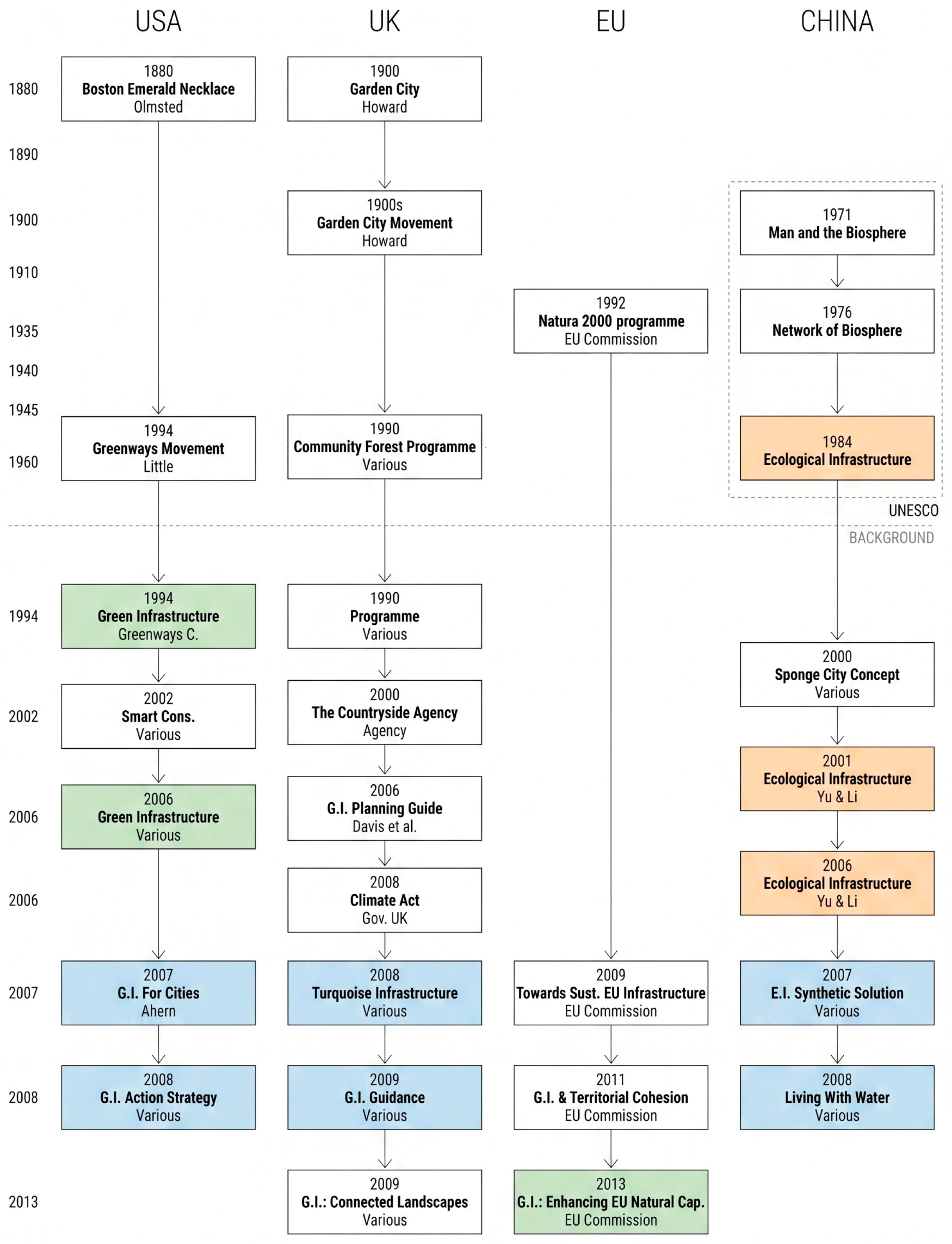
Figure 1 shows this development, highlighting how ideas from the USA, UK, Europe, and China have grown and merged. Nonetheless, as this section will show, the increasing standardisation of these terms by policymakers often emphasises broad categories over specific operational and hydrological details, leading to gaps in design practices. Fletcher et al. [
7] pointed out that urban water management terminology has become cluttered with overlapping terms, which tend to describe objects rather than operational functions, causing confusion among practitioners.
Figure 1 illustrates this timeline, mapping how theoretical strands from the USA, UK, Europe, and China have evolved and converged. It is important to note that this timeline deliberately focuses on the formative period (up to 2013) to trace the epistemological origins and first-degree conceptual shifts of these terms. Subsequent milestones from the last decade—such as the massive political rollout of the Sponge City national mandate in China or recent EU environmental laws—are understood in this study as second-degree policy derivations and operational extensions of the foundational frameworks established prior to 2013, rather than new theoretical paradigms.
2.1. Nature-Based Solutions and Typological Approaches
The origin of the term ‘GI’ is usually attributed to the Florida Greenways Commission, which first used it in 1994 [
21]. In the cover letter accompanying the report to the Governor of Florida, Lawton Chiles, the expert commission introduced the term ‘green infrastructure’ as ‘a new way of looking at our natural systems’ [
11]. While foundational, this initial approach primarily shaped the typological dimension of ecological infrastructure. By prioritising green open spaces and biodiversity networks over specific hydrological performance, this early strand initiated a trend that Lennon [
22] critiques as privileging static spatial assets over dynamic natural processes.
The executive director of the expert commission was Mark Benedict, who, in subsequent years, joined Edward McMahon at The Conservation Fund. The result of this collaboration is a definition of GI based on ecological planning at regional and urban scales, which the specialist literature recognises as the seminal definition: ‘Green Infrastructure is an interconnected network of natural areas and other open spaces that conserves natural ecosystem values and functions, sustains clean air and water, and provides a wide array of benefits to people and wildlife’ [
23] This conceptualisation of an interconnected network heavily draws upon the foundational principles of landscape ecology, specifically the spatial ‘patch-corridor-matrix’ model established by Forman [
24], which emphasises spatial connectivity as a prerequisite for ecological resilience.
Landscape architect and urban planner Jack Ahern was responsible for translating landscape ecology theory into design strategies applicable to resilient cities, and [
14] proposes that GI should be designed as hydrological buffers, which are activated during periods of heavy rainfall and river flooding. A second contribution is the proposal for adaptive planning and design, whereby GI should be treated as ongoing learning experiments. Finally, the principle of the multifunctionality of GI, developed in his scientific publication Green Infrastructure for Cities: The Spatial Dimension [
14], posits that a green corridor should not be reduced to mere aesthetics, but should be planned in such a way as to contribute across three simultaneous dimensions. The abiotic dimension relates to stormwater management and the reduction in heat islands—the two major challenges posed by climate change at present. He thus added a fourth regulatory function to the three ecosystem services that GI is expected to fulfil. These contributions represent a crucial early attempt to introduce a functional dimension to GI, explicitly defining the specific actions (e.g., buffering) required for urban flood mitigation.
The definition of GI put forward by the EPA is structured along the same lines: ‘GI comprises management approaches and technologies that utilise, enhance and/or mimic the natural hydrological cycle processes of infiltration, evapotranspiration and reuse’ [
25]. In this definition, the ‘green’ element is absent, and its great value lies in the fact that the focus is not on the physical object but on the processes and functions required to ensure the cyclical nature of the system. By emphasising specific hydrological responses rather than visual typologies, this theoretical strand directly informs the functional dimension of our proposed matrix. It establishes what Hoang and Fenner [
26] identify as the indispensable hydrological mechanisms required to successfully manage urban runoff.
Regrettably, this line of thinking did not gain traction, and what we might call ‘blue infrastructure’ never managed to establish itself as an autonomous category.
The ‘blue’ dimension began to gain prominence from 2008 onwards with the Climate Act and is reflected in a publication by Ian C. Mell [
27], who highlights the importance of water and introduces the term ‘blue-green or turquoise infrastructure’. However, it never managed to become an independent category and once again ended up being conceptually and imaginatively subsumed under the umbrella of green infrastructure. Despite Mell’s introduction of ‘turquoise infrastructure,’ the blue dimension was continually subsumed under the green umbrella, reinforcing a typological bias that focused on visual ‘assets’ rather than hydrological logic.
In 2013, the European Commission [
15] formalised the subordination of water to vegetation. This universal healing imperative of GI is ultimately carried over to Nature-Based Solutions, a new and more inclusive term that allows an ever-widening range of needs to be brought under one umbrella. This is formalised in the 2015 definition: ‘Nature-based solutions aim to help societies address a variety of environmental, social and economic challenges in sustainable ways’ [
28]. While NBSs serves as a highly effective, inclusive umbrella term for political communication and securing funding [
29], scholars warn against its reduction to a generic buzzword that lacks rigorous scientific application [
30].
Once a consensus had been reached on its definition in terms of public policy, all resources—and with them the associated research—have been channelled into the development of standardised and culturally accepted solutions, which prioritise breadth over the depth of scientific advances that subsequently underpin the projects tasked with achieving effective sustainability over time. And, in doing so, this has reduced the operational scope and sphere of influence of designers and planners concerned with providing concrete solutions that truly align with the processes and entropy of natural cycles.
This historical trajectory justifies the urgent need for a new interpretative matrix: relying solely on policy-driven typological classifications limits the operational scope of designers seeking to mitigate urban flooding.
2.2. Ecological Infrastructures and System Thinking
In contrast to this typological approach centred on objects (which are often autonomous and isolated), Kongjian Yu developed an alternative method and terminology, more in keeping with Eastern thought and rooted in systems thinking. Whilst much of the Western literature has prioritised the classification of elements (green infrastructure, green-blue infrastructure), Kongjian Yu revives the broader concept of ‘ecological infrastructure’, understood as a network of interconnected processes across multiple scales.
To this end, he drew inspiration from the work of UNESCO, which, under the Man and the Biosphere (MAB) Programme, first established a global network of biosphere reserves [World Network of Biosphere Reserves] in 1976, before introducing the concept of ‘ecological infrastructure’ in a more general sense in 1984 [
18]. This term is more holistic and moves beyond a characterisation of infrastructure based on visual aspects such as green and blue, focusing instead on the underlying ecological values and processes, regardless of the context to which they belong.
Drawing on the idea and methodology of ‘Ecological Security Patterns’ that he developed for his doctoral thesis (1995), Yu, together with Li, defines ecological infrastructure as the structural landscape network composed of critical landscape elements and spatial patterns that safeguard the integrity and identity of natural and cultural landscapes. Sustaining the ecosystem, protecting cultural heritage sites and creating recreational opportunities are also considered in this process [
19].
What is distinctive about this approach is that it takes into account the entire system, ranging from the regional scale—with the river basin as the basic hydro-geographical unit—to the local scale with ‘sponge parks’, a concept developed in 2000, where all components work in a coordinated manner according to specific and complementary functions. Thus, infrastructure is not a sum of objects, or the positive, but rather its inverse—the negative, or ‘the non-buildable framework for urban development’ [
31]. Ecological infrastructure is the interconnected network that cannot be altered without disrupting the processes that sustain life. It is both a system and a set of functions. For Yu, the catchment area precedes the object, connectivity precedes form, and function precedes typology. This aligns with recent calls in the literature emphasising that ecological interventions must be systemically coupled—spatially, operationally, and institutionally—with the existing urban fabric, rather than inserted as isolated, standalone objects [
32].
Another distinctive aspect of Yu’s work is that he was both a researcher and a designer. In other words, theory and practice went hand in hand, feeding into one another. The wide variety of projects he undertook enabled him to gradually refine both his theory and his practice, leading him to one of his key conclusions: that water is the primary organiser of the set of ecological functions, and that the environmental and ecological problems of cities should be solved through planning based on hydrology. This systemic, catchment-based approach directly informs the operational dimension of the framework proposed in this study, echoing Zevenbergen et al. [
33], who argue that resilient urban design must be operationally coupled with the hydrological dynamics of the wider catchment area.
3. Case Study Selection and Evaluation Criteria
To empirically evaluate different approaches to urban water management in the face of the climate crisis, this research adopts a qualitative methodological design based on comparative case studies. This approach allows for the comparison of advanced infrastructure models which, whilst operating under unique geographical, climatological and socio-political constraints, share the imperative of mitigating urban hydrometeorological risk. Four global case studies were deliberately selected to represent highly divergent and specialised adaptation approaches.
These four global case studies were deliberately selected because they represent the extreme ends of the ecological infrastructure spectrum—ranging from Tokyo’s purely grey engineering to Singapore’s highly integrated blue-green model. While this diversity in spatial scale (ranging from neighbourhood-level squares to metropolitan-wide underground tunnels) presents a comparative challenge, it is essential for testing the framework. Examining vastly different scales allows us to determine whether fundamental hydrological functions (e.g., storage) remain constant operational imperatives regardless of the size or material of the intervention. It is important, however, to acknowledge a selection bias: these four examples represent highly resourced, developed contexts in the Global North and Asia. While the specific material solutions may not be easily transferable to less affluent regions, the underlying functional-operational framework proposed in this study remains a universally applicable analytical tool.
3.1. Towards a Functional-Operational Interpretation
The problem of urban flooding is a water-related issue. Therefore, the analysis of the problem must be situated within the water-related dimension. However, in the classical typology, it is placed at the bottom of the hierarchy, as an appendix to the ‘grey’ and ‘green’ elements, which does little to help visualise the problem or conceptualise it. The theoretical background outlined in the previous sections highlights two critical gaps in current practice: the conceptual subordination of hydrological (blue) functions to vegetative (green) typologies, and the lack of a systemic, scale-appropriate methodology for designers. A three-part interpretative matrix is therefore proposed to structure and prioritise the layers of information to be superimposed on the conventional typological classification of GI, BGI and NBSs. This matrix adds a vital operational layer to conventional typological classifications, explicitly addressing the shortcomings of past frameworks by structuring the analysis across three dimensions:
3.1.1. Typological/Material
Once the type of existing infrastructure (grey, green, blue) has been identified, the next step is to establish the proportionality of each within the broader network. This baseline assessment defines the different operating logics and material constraints that need to be taken into account prior to design implementation.
3.1.2. Operational
From an operational perspective, the underlying reality is the hydrological logic. Therefore, the first analytical step requires defining the hydrological logic at work in the floodplain. For instance, identifying whether soil saturation is driven by geographical, geological, or altitudinal constraints (e.g., deltaic regions located below sea level) is essential. This enables practitioners to understand the specific function that ecological infrastructure must fulfil so that water can complete the water cycle in a resilient manner.
The second criterion is the scale of influence and intervention. This is inextricably linked to the type of catchment that needs to be addressed. Each scale corresponds to a specific catchment and a specific volume of water that can be estimated or calculated using the water balance.
Finally, we must consider the degree to which both existing infrastructure, as well as that yet to be planned, is integrated with the hydrological cycle. One way of understanding entropy—and with it the unnecessary loss of energy and matter within a system—is the resistance we place on the natural flow of things. The more we respect the specific functions of the different states of water within its hydrological cycle, the lower the resistance and the lower the entropy of the urban system.
3.1.3. Functional/Specific Action
The three main functions to be addressed in flood mitigation are the rapid conveyance of water, its storage and its infiltration. While calculating their volumes, flow rates and the forces exerted is the task of engineers, determining their location, their timing, and the extent to which they are integrated into the natural cycle is the critical task of architects and urban planners.
3.2. Analytical Framework and Comparative Variables
To systematise the technical and operational information from the selected case studies, a standardised comparative matrix was designed. This methodological tool enables the complexity of each model to be broken down through the cross-evaluation of three dimensions.
Typological/Material Dimension: Assesses the physical composition of the infrastructure, identifying the predominance or hybridisation of ‘Grey’ (concrete, traditional channels), ‘Green’ (vegetation-based solutions) and ‘Blue’ (integrated water bodies) elements.
Operational Dimension: Analyses the behaviour of the system within its territorial context through three subcategories: hydrological logic (defines the operational philosophy regarding flooding, e.g., artificial containment versus adaptation); scale (the type of watershed impacted); and degree of coupling (how well the infrastructure is integrated with the local topography and the city’s complete hydrological cycle).
Functional Dimension (Specific Action): Determines the dominant hydrological mechanism in the face of a critical event, categorising the response into the three primary functions of water-sensitive design: conveyance (transport and drainage), infiltration (retention and permeability at source) and storage (volumetric buffering).
3.3. Case Studies
Infrastructure case studies reveal highly diverse strategies tailored to unique geographical, climatic, financial and socio-political constraints. The following profiles detail the approaches taken by Singapore, Copenhagen, Rotterdam and Tokyo, providing the technical and operational data required for a comprehensive comparison, which can then be analysed and contrasted using the matrix proposed earlier.
3.3.1. Rotterdam Water Squares: Adaptive Surface Drainage
Located in a highly vulnerable, low-lying river delta, where approximately 85 per cent of the city’s area lies up to 7 m below sea level, Rotterdam faces persistent and existential threats from rising sea levels, river flooding from the Rhine and Meuse, and increasingly frequent extreme rainfall [
34]. As a space-constrained, flood-prone city lacking the lateral room for extensive natural floodplains, Rotterdam clearly exemplifies the implementation of adaptive, hybrid solutions. Rather than simply building dykes and fighting the water through brute engineering, the city structurally integrates water into its spatial planning and public spaces.
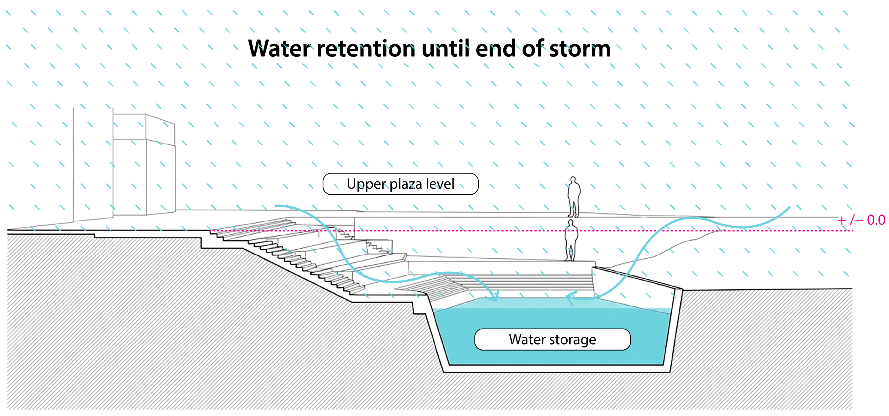
A prime example of this specific approach is the creation of ‘Water Squares’ (waterpleinen) (
Figure 2). The Benthemplein Water Square, completed in 2013, serves as the world’s first full-scale installation of this hybrid typology [
35]. In dry weather, the 5500-square-metre square serves as a vibrant and heavily used public space featuring a skate park, an open-air theatre and sports pitches [
35]. However, during heavy rainfall, runoff from the roofs of surrounding buildings and paved surfaces is channelled through visible, oversized stainless-steel gutters into three separate concrete basins [
36].
These basins provide vital retention, temporarily decoupling rainfall from the overburdened sewerage system. Benthemplein Square alone has an impressive storage capacity of up to 1800 cubic meters of rainwater [
37]. The water is deliberately retained locally until the city’s wider sewerage systems and canals have regained sufficient capacity, at which point the basins are slowly drained, allowing the water to seep back into the groundwater or into the open water system, and the square is subsequently cleaned [
38].
Rotterdam’s wider ‘Climate Proof’ programme extends far beyond individual squares.
It includes the construction of over 130,000 square meters of green roofs, the implementation of extensive ‘blue-green corridors’ to facilitate natural hydrological processes on the city’s outskirts, and the engineering of vast underground grey storage facilities, such as the Museumpark car park, which covertly retains 10,000 cubic meters of emergency water [
39]. This robust and highly calculated blend of grey engineering with multifunctional blue-green architecture exemplifies Rotterdam’s overall strategy to enhance its urban ‘sponge’ function whilst simultaneously elevating the socio-cultural and aesthetic value of the public realm [
39].
3.3.2. The Copenhagen Cloudburst Plan: Distributed Urban Storage
Copenhagen’s city-wide strategic shift towards blue-green infrastructure was urgently catalysed by a catastrophic 1000-year storm on 2 July 2011. In less than two hours, a massive 150 mm of rain flooded the Danish capital. The sheer volume of rainfall overwhelmed the combined sewer system, sending contaminated floodwater into buildings and critical infrastructure, causing approximately USD 1 billion in socio-economic damage [
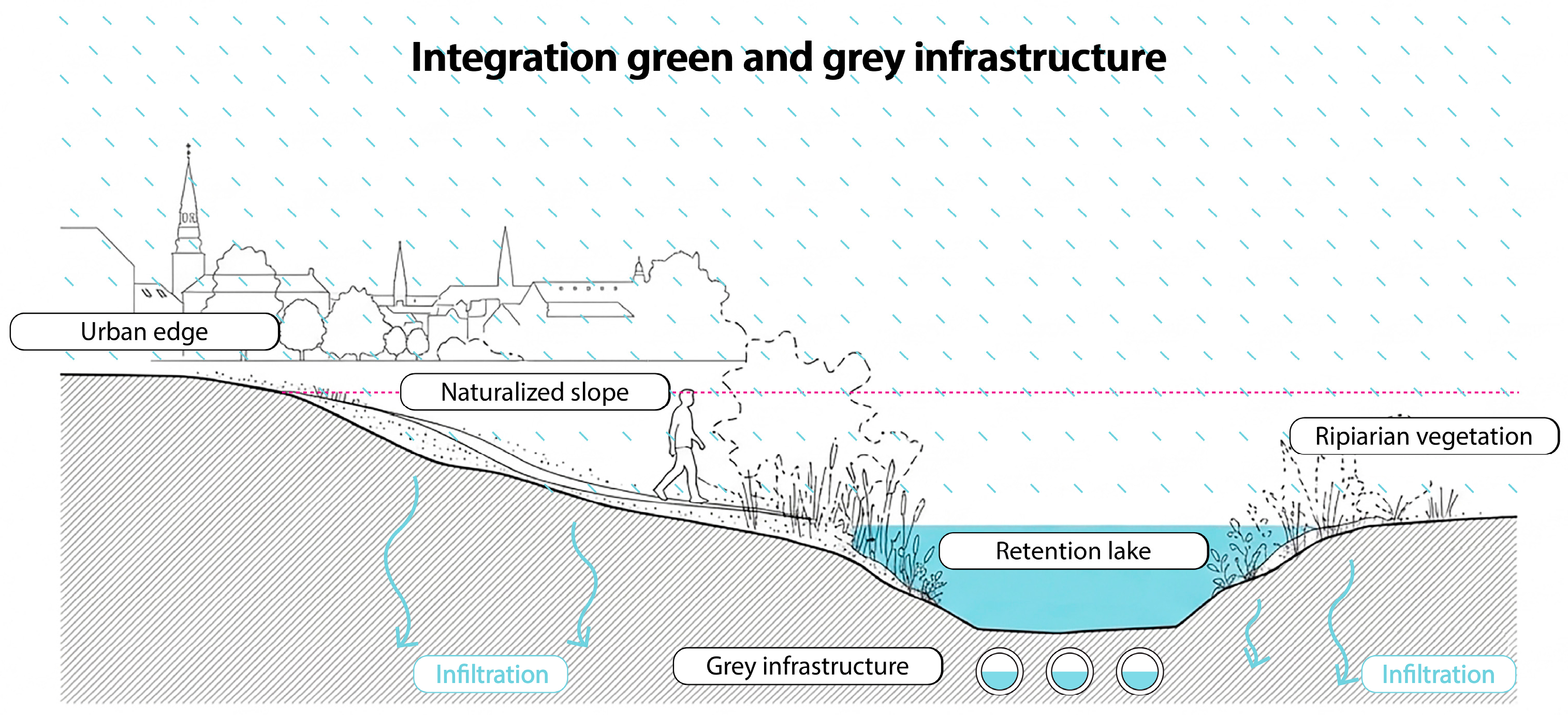
40]. Recognising that traditional piped underground solutions would be prohibitively expensive to expand, technically insufficient to cope with future climate projections, and spatially impossible to construct in the densely built-up historic centre, the municipality developed the world’s first comprehensive, city-wide Cloudburst Management Plan [
40] (
Figure 3).
Copenhagen’s master plan operates on a distinct hydrological approach to surface-level water management, working in tandem with natural topographical cycles to safely drain and retain water. The strategy involved dividing the entire city, covering 179.8 square kilometres, into specific stormwater catchments and meticulously planning more than 300 integrated infrastructure projects intended to be implemented over a 20-year period [
40]. To standardise this massive undertaking, the plan introduced a typology-based ‘Cloudburst Toolkit’, comprising five core architectural interventions: cloudburst boulevards (designed for rapid surface conveyance), underground pipes (for unavoidable underground conveyance), retention boulevards (designed to delay flow), central retention basins (large-scale basins for water storage) and greenways (for local conveyance and delay) [
41].
A defining feature of this masterplan is the radical transformation of standard urban streets and public squares into temporary blue corridors. During extreme rainfall events, these spaces are intentionally flooded to a manageable tolerance level, acting as surface-level rivers that channel water towards the harbour or large recreational lakes, thereby immediately relieving pressure on the underground sewerage network. For example, the integration of blue-green solutions into the city’s central lake projects involved permanently lowering baseline water levels to create new, massive emergency storage capacities.
This precision engineering created a stormwater storage volume of 40,000 cubic meters in a revitalised riverside area that functions as a public space during dry weather [
40]. Crucially, Copenhagen justified this massive municipal transition through a rigorous socio-economic cost-benefit analysis. The analysis demonstrated that a master plan prioritising a high proportion of blue-green solutions over purely conventional grey infrastructure yielded potential direct financial savings 50 per cent higher than traditional underground methods [
40]. Furthermore, overcoming the financial barriers to implementation required innovative polycentric governance; the city successfully lobbied for legal changes at the national level that enabled the regional water utility (HOFOR) to co-finance multifunctional blue-green infrastructure at the surface level using water charges, fundamentally changing the way green infrastructure is financed [
41].
3.3.3. Singapore’s ABC Waters Programme: Territorial Integration of Water Resources
Singapore is a highly densely populated island city-state with a scarcity of land, facing significant and compound vulnerabilities with regard to both rainwater flooding caused by intense tropical monsoon storms and long-term freshwater scarcity due to its limited natural catchment area [
42]. To address these twin challenges simultaneously, the Public Utilities Board (PUB) of Singapore launched the Active, Beautiful and Clean Waters (ABC Waters) Programme in 2006, shifting the city’s focus from purely functional drainage towards integrated, catchment-based planning [
43]. This model highlights the profound regulatory and ecological integration required to achieve simultaneous flood resilience and biodiversity enhancement.
The core strategy of the ABC Waters Programme involves the systematic transformation of the city’s legacy of utilitarian concrete drains, canals and reservoirs into naturalised, meandering rivers and vibrant, ecologically rich community spaces. The hydrological logic here represents a complete integration of the water cycle into the urban fabric, ensuring that water catchment, drainage, treatment and recreational use coexist seamlessly within a single, highly engineered ecological system.
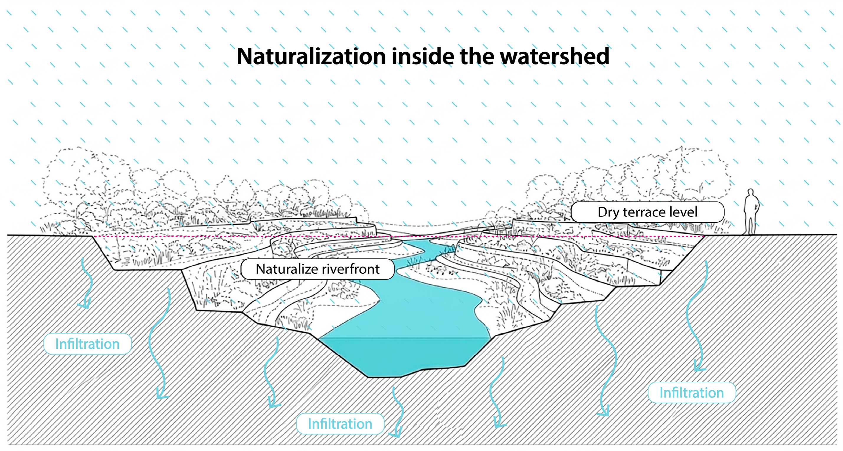
A flagship and globally recognised example of this paradigm is the Kallang River in Bishan-Ang Mo Kio Park (
Figure 4). Previously a 2.7-kilometre-long, straight concrete drainage channel, the infrastructure was completely renaturalised into a 3.2-kilometre-long meandering river integrated within a 62-hectare community park [
44]. The design makes elegant use of the concept of a floodplain; during dry weather, the river is a narrow, gentle stream, allowing public access directly to the water’s edge. However, during heavy tropical downpours, the adjacent park serves as a conveyance channel and a temporary retention basin, safely managing large volumes of water [
45]. This specific soil bioengineering project increased the waterway’s flood-carrying capacity by 40 per cent whilst simultaneously creating a habitat that significantly boosted local biodiversity [
46].
From a strictly technical and regulatory perspective, the ABC Waters Programme requires strict controls on the amount of runoff to manage volume and capacity at the catchment scale. Urban developments larger than 0.2 hectares are legally required to limit their maximum runoff coefficient (C-value) to 0.55 or less [
47]. To achieve this demanding metric, decentralised solutions at source—such as rain gardens, vegetated bio-ditches, purification biotopes and permeable pavements—are being aggressively implemented across the urban landscape [
48]. These features focus primarily on the specific hydrological actions of retention and infiltration. Furthermore, ABC Waters’ design features treat stormwater runoff biologically. Extensive field monitoring has demonstrated that these systems provide significant removal efficiencies for total suspended solids (TSS), total phosphorus (TP) and total nitrogen (TN), ensuring that urban runoff is cleaned before entering the city’s drinking water reservoirs [
48].
Through robust regulatory frameworks such as the Landscaping for Urban Spaces and High-Rise Buildings (LUSH) programme, which mandates 100 per cent vegetation replacement for new developments, Singapore has successfully transformed grey infrastructure into blue-green public assets. As a result, the city-state has increased its green space coverage to approximately 47 per cent [
49]. This extensive blue-green coverage not only mitigates flood risks but also actively regulates the microclimate, substantially reducing the urban heat island effect [
50].
3.3.4. Tokyo Metropolitan Flood Protection System: Centralised Hydraulic Optimisation
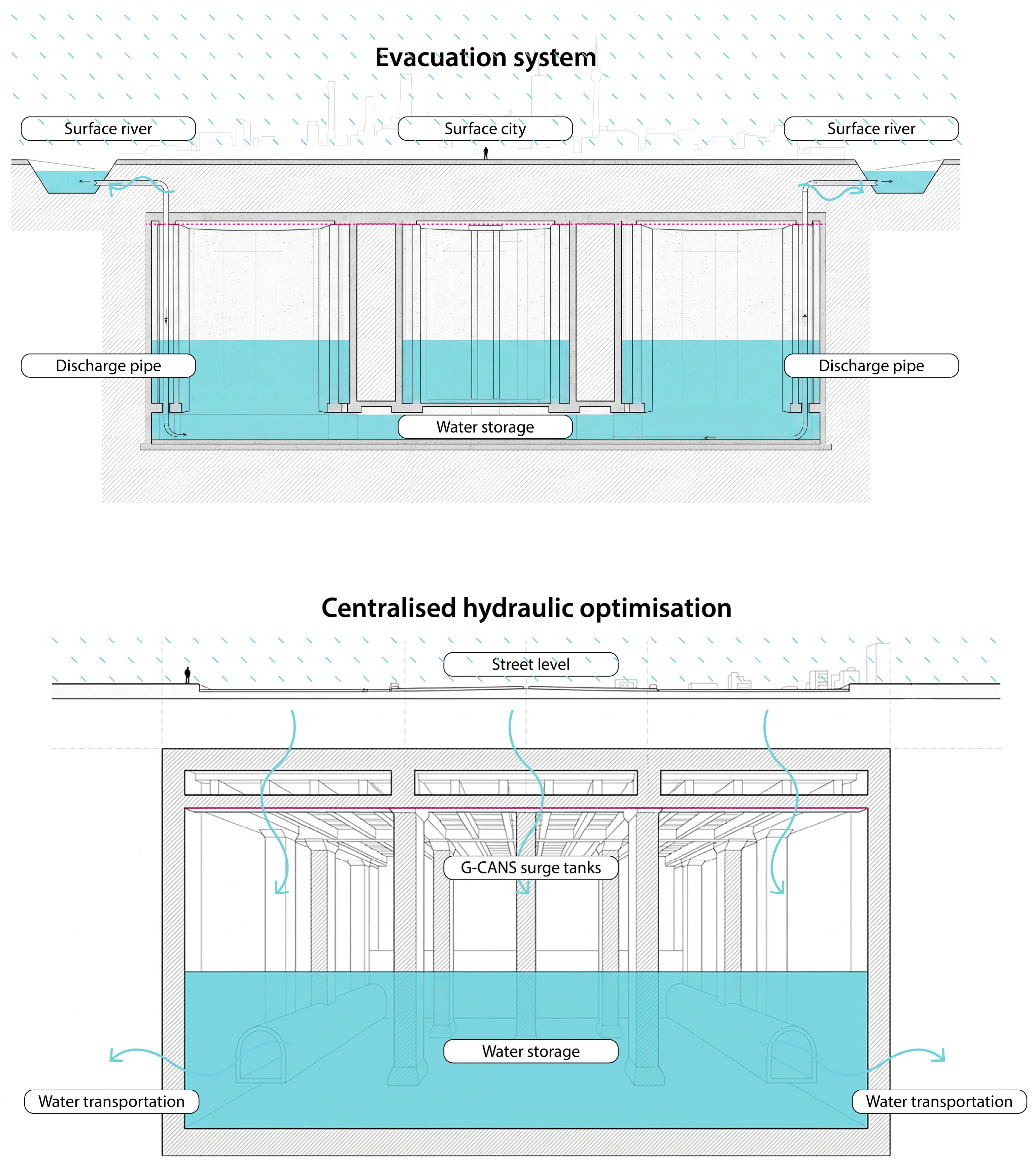
In stark contrast to the surface-level ecological approach taken by Singapore or Copenhagen, Tokyo relies heavily on a major feat of civil engineering: the Greater Tokyo Area Underground Discharge Channel, known worldwide as G-CANS (
Figure 5). The Greater Tokyo Area is one of the most densely populated megacities on Earth, built mainly on low-lying land reclaimed from the sea and crisscrossed by numerous major rivers [
50]. This unique geography makes the metropolis exceptionally vulnerable to catastrophic river flooding during the intense Pacific typhoon season [
51]. This project vividly illustrates both the absolute necessity and the ecological limits of massive grey infrastructure in hyper-dense urban environments.
G-CANS represents a prime example of ‘Engineering Vision’, deploying massive, inflexible infrastructure on a territorial scale to forcibly control and manipulate the hydrological cycle. Built 50 m below ground level to avoid the complex network of underground railways and urban utilities, the system consists of five enormous concrete containment silos—each 65 m high and 32 m in diameter—connected by 6.4 kilometres of underground tunnels. These tunnels actively collect overflow from smaller, flood-prone urban rivers and transport the water to a colossal pressure-regulating balancing reservoir, famously nicknamed the ‘Underground Temple’ due to the 59 enormous 500-tonne concrete pillars that support its cavernous ceiling.
The primary function of the G-CANS system is rapid diversion and drainage. When storm water levels in the balancing reservoir reach a critical operational threshold, four turbines—powered by modified Boeing 737 jet engines—pump the floodwater out of the tank into the much larger Edo River at an astonishing rate of 200 cubic meters (or 200 tonnes) per second, safely discharging it into Tokyo Bay [
51]. The total storage capacity of the main balancing reservoir is a staggering 67,000 cubic meters, whilst other connected infrastructure, such as the Furukawa Reservoir, provides an additional 135,000 cubic meters of volume [
51].
Whilst G-CANS is a purely ‘grey’ infrastructure system lacking ecological integration, it serves as a critical enabler for the metropolis above. Massively expanding the city’s underground drainage capacity enables the dense urban fabric to remain highly functional and economically stable during extreme 1-in-200-year disaster events, reportedly reducing flood damage by two-thirds since its completion [
51]. However, recognising the limitations of purely ‘grey’ solutions, Tokyo and Japanese environmental policy more broadly are increasingly acknowledging the need to combine these mega-structures with green spaces on the surface, using initiatives such as the Urban Green Spaces Act to mandate minimum levels of green cover in new private developments to complement the underground engineering.
4. Results and Discussion
To synthesise the case studies, the diverse and complex approaches of the projects in Singapore, Copenhagen, Rotterdam and Tokyo are presented in a standardised comparative matrix (
Table 1). Addressing previous ambiguities in typological classifications, this matrix maps the interventions against specific quantitative and qualitative metrics. Qualitative rankings (e.g., ‘High’, ‘Low’) are grounded in observable physical metrics, such as percentage of green cover, volumetric storage capacities (m
3), and legal runoff coefficients.
4.1. The Absence of an Ideal Infrastructure Value (Structural Heterogeneity)
The results demonstrate that the search for an optimal ratio or universal mathematical coefficient between grey, green and blue infrastructure constitutes a conceptual error in water planning. The optimal composition of the infrastructure network is intrinsically determined by the geomorphological, geographical, climatological, and urban-density constraints of each local area. These findings empirically validate the theoretical concerns raised by Nesshöver et al. [
29] and Seddon et al. [
30] regarding the limitations of treating NBSs as generic, universally applicable solutions. As previously discussed, standardising green infrastructure without considering the underlying hydrological logic leads to the ‘typological trap’ [
7].
Tokyo represents the pinnacle of grey infrastructure optimisation, providing immediate protection for a subsoil saturated with utilities and a hyper-dense built environment on land reclaimed from the sea. Conversely, Singapore and Copenhagen operate under a reverse paradigm of dismantling the grey infrastructure matrix. The latter cities demonstrate that, when expanding sewerage networks is impractical and prohibitively costly, maximising green spaces and blue corridors enhances urban resilience. For its part, Rotterdam illustrates a pragmatic and hybrid approach: as it lies largely below sea level in an unstable delta, it lacks the lateral space to rely exclusively on nature-based solutions, and is therefore compelled to integrate large-scale grey infrastructure with functional blue-green features within the public domain. This confirms that there is no static mathematical optimum, but rather a dynamic and context-specific approach that prioritises hydrological function over visual typology.
4.2. Operational Effectiveness as a Function of Systemic Coupling
The research reveals that the hydraulic success of an intervention does not depend on the intrinsic properties of an isolated component (e.g., a single rain garden), but rather on the level of systemic coupling it achieves—physically, spatially, and institutionally—with its surroundings. This empirical evidence directly supports the theoretical paradigm of ‘ecological infrastructure’ championed by Yu and Li [
19], which posits that connectivity and network integration must precede individual forms. Furthermore, it grounds Frantzeskaki’s [
32] assertion that ecological interventions cannot act as standalone objects but must be structurally woven into the urban fabric. Three critical dimensions of coupling were identified:
Physical and Topographical Coupling: Demonstrated by Copenhagen, where the Cloudburst Plan rigidly adheres to the natural slopes of the urban surface terrain to passively drain water by gravity towards the harbour, minimising reliance on energy-intensive mechanical systems.
Spatial and Socio-Cultural Coupling: Evidenced in Rotterdam through the ‘Water Squares’ typology. The system temporarily couples with the urban network, shifting its social (recreational) role to that of emergency hydraulic buffering infrastructure precisely during the peak of the storm, thereby relieving pressure on the central collectors.
Regulatory and Institutional Coupling at the Catchment Scale: Illustrated in Singapore, where regional hydraulic success depends on the enforced compliance with a decentralised legal framework (C ≤ 0.55 for developments > 0.2 ha). This regulatory linkage transfers responsibility for retention to the private sector at source, ensuring cumulative resilience that protects the macro-catchment.
While these projects operate at vastly different spatial scales, the necessity of systemic coupling remains a constant requirement for operational success.
4.3. Functional Matrix (Grey, Green, Blue)
Through a cross-analysis of mechanical and ecological interventions, a clear specialisation of critical functions—which are unambiguously distributed according to the type of infrastructure—is empirically validated, as summarised in
Table 2:
4.4. The Universality of Blue Infrastructure (Storage as a Systemic Buffer)
The most significant theoretical and empirical contribution of this comparative study lies in the identification of blue infrastructure (dynamic volumetric storage) as an absolute and inescapable common denominator across the four models analysed, regardless of the construction materials or design philosophy under which the system is formally classified.
In the surface-level adaptive schemes of Singapore, Copenhagen and Rotterdam, the ‘blue’ function is manifested in an explicit, visible and ecologically integrated manner: it can be observed in the Kallang River floodplain, in the controlled lowering of Copenhagen’s lakes, and in the exposed concrete basins of Benthemplein (1800 m3). However, it is the in-depth analysis of Tokyo’s hyper-grey model that definitively validates this finding. Although the G-CANS system is universally classified as a rigid example of grey engineering due to its millions of tonnes of underground concrete and its complete disconnection from surface biological cycles, its hydraulic and operational viability is entirely dependent on a massive, covert blue function.
The physics of the system dictate that accelerated discharge at 200 m3/second via industrial turbines is physically impossible to achieve directly from disordered torrential stormwater flows. The G-CANS system is obliged to dampen the hydraulic energy and retain volumetric peaks within its colossal surge tank (the ‘Underground Temple’, with a capacity of 67,000 cubic meters) and in associated structures such as the Furukawa Reservoir (135,000 cubic meters).
Therefore, storage acts as a ‘systemic buffer.’ It is not merely a localised functional role; rather, it temporarily decouples peak rainfall from runoff, preventing cascading failures throughout the entire conveyance network. This physical reality empirically grounds Jack Ahern’s [
14] theoretical ‘safe-to-fail’ principle. Without this volumetric buffer to absorb extreme climatic shocks, the entire grey and green infrastructure system collapses under hydraulic overload.
Consequently, the blue function—scientifically understood as the capacity for volumetric storage and temporal buffering of flows—constitutes the indispensable operational core, even within the most extreme grey engineering paradigm on the planet. This finding subverts the classic dichotomy between grey and blue-green infrastructure, demonstrating that volumetric storage is a universal physical imperative for mitigating urban water risk.
4.5. Operationalising the Framework: A Step-by-Step Guide for Practitioners
To transition this theoretical framework into actionable urban design practice, it is essential to contextualise it within existing knowledge. Unlike conventional typological frameworks—such as the early categorisations by the EPA [
25] or the EU Commission [
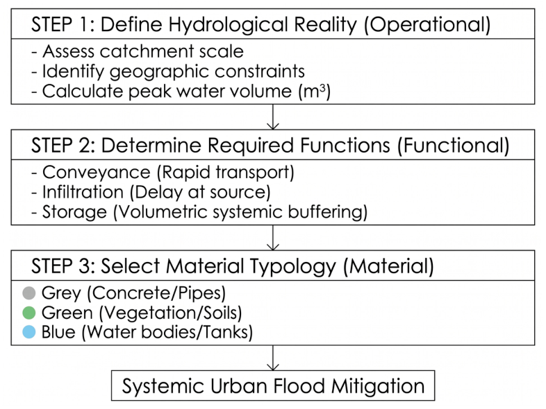
15], which primarily supply static catalogues of physical assets (e.g., green roofs, permeable pavements)—the proposed functional-operational matrix prioritises hydrological physics over visual characteristics. Furthermore, while widely accepted contemporary frameworks, such as the IUCN Global Standard for Nature-based Solutions, excel at evaluating broad socio-ecological benefits and policy alignment, they often lack specific hydraulic operational sequencing for designers. By inverting the traditional design sequence—placing catchment scale and volumetric function before material selection—this framework provides a novel, pragmatic bridge between high-level environmental policy and site-specific engineering. Planners and landscape architects can apply this matrix through the following sequential decision-making process (
Figure 6):
Define the Hydrological Reality (Operational): Assess the specific catchment scale and the underlying geographical constraints (e.g., gravity-fed slopes vs. flat deltaic soils). Determine the volume of water (m3) that needs to be managed during a peak event.
Determine the Required Functions (Functional): Based on the volumes calculated, prioritise the necessary hydrological actions. If soils are saturated, infiltration (green) must be minimised, and volumetric storage (blue) must be maximised.
Select the Material Typology (Material): Only after functions are defined should the designer select the physical typology. Choose hybrid (grey/green/blue) configurations that fulfil the specific functional requirement while spatially coupling with the socio-cultural needs of the site (e.g., a water square).
4.6. Limitations of This Study
While the proposed framework offers a robust analytical tool, this study acknowledges certain contextual limitations. The selected case studies—Rotterdam, Copenhagen, Singapore, and Tokyo—represent highly resourced, economically affluent cities situated in the Global North and developed Asia. These municipalities possess strong institutional governance, strict regulatory enforcement, and significant capital to finance mega-infrastructure. Consequently, the specific material interventions (such as billion-dollar underground tunnels or citywide cloudburst master plans) may not be directly transferable to developing nations or cities with informal urban settlements and limited financial capacity. However, while the material typologies may not be universally replicable, the underlying functional-operational framework (identifying the need for conveyance, infiltration, and particularly storage) remains a universally applicable methodology for diagnosing and designing flood mitigation strategies in any context.
4.7. Future Implications
Looking forward, the implications of this study suggest a necessary shift in both urban water policy and design education. Regulatory frameworks must evolve from mandating superficial green coverage to demanding specific functional performance, much like Singapore’s mandated runoff coefficient (C-value ≤ 0.55). Furthermore, future research should focus on adapting this functional-operational framework to the realities of the Global South and developing nations, exploring how decentralised storage and systemic coupling can be achieved in resource-constrained or informal urban settings. Ultimately, embracing a process-oriented understanding of ecological infrastructures is essential to designing resilient cities that can withstand an increasingly volatile climate.
5. Conclusions
This study argues that the effectiveness of urban flood mitigation cannot be explained by the predominance of a particular type of infrastructure, but rather by the way in which different ecological infrastructures interact as a coordinated hydrological system. The comparative analysis demonstrates that grey, green and blue infrastructures fulfil complementary rather than competing functions. Consequently, ecological infrastructure should not be understood as a collection of independent objects or standardised Nature-Based Solutions, but as a network of functional relationships operating across multiple spatial scales. From a design perspective, the critical task is therefore not to select a preferred typology, but to define the appropriate combination of functions required by the hydrological conditions of each catchment.
A second contribution of this study is the identification of temporary water storage (the ‘blue’ function) as the only operational constant across all four international cases analysed. Regardless of whether flood mitigation relies predominantly on grey engineering (like Tokyo’s 67,000 m3 underground surge tanks), hybrid systems (like Rotterdam’s 1800 m3 water squares) or nature-based interventions (like Copenhagen’s 40,000 m3 lake retentions), every successful strategy incorporates a buffering mechanism capable of temporarily decoupling rainfall from runoff. In this sense, blue infrastructure should not be interpreted exclusively as visible water bodies or aquatic landscapes, but, more fundamentally, as the systemic function responsible for providing storage capacity, introducing temporal flexibility, reducing hydraulic peaks, and increasing the resilience of the urban hydrological cycle. This finding suggests that storage represents a universal physical requirement for flood mitigation, irrespective of the material form of the infrastructure.
Finally, the functional-operational interpretative matrix proposed in this article provides a complementary analytical framework to existing typological classifications such as Green Infrastructure, Blue-Green Infrastructure and Nature-Based Solutions. Rather than replacing these concepts, the framework adds an operational layer that supports both the diagnosis of flood-related problems and project-based decision-making. By organising infrastructure according to hydrological logic, catchment scale, and primary function (conveyance, infiltration, and storage), the matrix enables planners, landscape architects, and architects to move away from catalogues of solutions towards a process-oriented understanding of ecological infrastructures. This shift helps to bridge the persistent gap between environmental discourse and operational design practice.
Author Contributions
C.S.-M.: conceptualisation, methodology, writing, review, visualisation, and validation. C.M.: conceptualisation, methodology, writing, review, visualisation, and validation. All authors have read and agreed to the published version of the manuscript.
Funding
This research received no external funding.
Institutional Review Board Statement
Not applicable.
Informed Consent Statement
Not applicable.
Data Availability Statement
The original contributions presented in the study are included in the review; further data inquiries can be directed to the corresponding author.
Acknowledgments
Whilst preparing this paper, the authors used OpenAI ChatGPT, GPT-5.6 Thinking model to assist with structuring the manuscript. Grammarly was used for language editing and academic writing. After using this tool, the authors reviewed and edited the content as necessary and accept full responsibility for the content of the submitted manuscript.
Conflicts of Interest
The authors declare no conflicts of interest.
References
- Seguel-Medina, C.; Nijhuis, S.; Sepulveda-Carmona, D. Towards a landscape-based approach for planning and design in complex urban geomorphologies: A case study of Valparaíso, Chile. Landsc. Archit. Sustain. 2025, 1, 100003. [Google Scholar] [CrossRef] [Scilit]
- Bartesaghi-Koc, C.; Osmond, P.; Peters, A.H. Towards a comprehensive green infrastructure typology: A systematic review of approaches, methods and typologies. Urban Ecosyst. 2017, 20, 15–35. [Google Scholar] [CrossRef] [Scilit]
- Ying, J.; Zhang, X.; Zhang, Y.; Bilan, S. Green infrastructure: Systematic literature review. Econ. Res.-Ekon. Istraz. 2022, 35, 343–366. [Google Scholar] [CrossRef] [Scilit]
- Pauleit, S.; Zölch, T.; Hansen, R.; Randrup, T.B.; Konijnendijk van den Bosch, C. Nature-Based Solutions and Climate Change: Four Shades of Green. In Nature-Based Solutions to Climate Change Adaptation in Urban Areas; Kabisch, N., Korn, H., Stadler, J., Bonn, A., Eds.; Springer: Cham, Switzerland, 2017; pp. 29–49. [Google Scholar]
- Sowińska-Świerkosz, B.; García, J. What are Nature-based Solutions (NBS)? Setting core ideas for concept clarification. Nat.-Based Solut. 2022, 2, 100009. [Google Scholar] [CrossRef] [Scilit]
- Seguel-Medina, C. Paradigm Change: A landscape-based approach as a new paradigm for Valparaiso. J. Delta Urban. 2024, 5. [Google Scholar] [CrossRef] [Scilit]
- Fletcher, T.D.; Shuster, W.; Hunt, W.F.; Ashley, R.; Butler, D.; Arthur, S.; Trowsdale, S.; Barraud, S.; Semadeni-Davies, A.; Bertrand-Krajewski, J.L.; et al. SUDS, LID, BMPs, WSUD and more–The evolution and application of terminology surrounding urban drainage. Urban Water J. 2015, 12, 525–542. [Google Scholar] [CrossRef] [Scilit]
- Olmsted, F.L. Annual Report of the Architect in Chief; Department of Parks, City of Boston: Boston, MA, USA, 1881.
- Howard, E. Garden Cities of To-Morrow, 2nd ed.; Swan Sonnenschein & Co.: London, UK, 1902. [Google Scholar]
- Little, C.E. Greenways for America; Johns Hopkins University Press: Baltimore, MD, USA, 1990. [Google Scholar]
- Florida Greenways Commission. Report to the Governor: Vision of Florida’s Statewide Greenways System; Florida Department of Environmental Protection: Tallahassee, FL, USA, 1994. [Google Scholar]
- Davies, C.; MacFarlane, R.; McGloin, C.; Roe, M. Green Infrastructure Planning Guide; University of Northumbria, North East Community Forests: Newcastle upon Tyne, UK, 2006. [Google Scholar]
- UK Government. Climate Change Act 2008; The National Archives: London, UK, 2008.
- Ahern, J. Green infrastructure for cities: The spatial dimension. In Cities of the Future: Towards Integrated Sustainable Water and Landscape Management; Novotny, V., Brown, P., Eds.; IWA Publishing: London, UK, 2007; pp. 267–283. [Google Scholar]
- European Commission. Communication from the Commission: Green Infrastructure (GI)-Enhancing Europe’s Natural Capital (COM 2013 249 Final); European Commission: Brussels, Belgium, 2013. [Google Scholar]
- UNESCO. Man and the Biosphere Programme; UNESCO: Paris, France, 1971. [Google Scholar]
- UNESCO. World Network of Biosphere Reserves; UNESCO: Paris, France, 1976. [Google Scholar]
- Reed, M.G. The contributions of UNESCO Man and Biosphere Programme and biosphere reserves to the practice of sustainability science. Sustain. Sci. 2019, 14, 809–821. [Google Scholar] [CrossRef] [Scilit]
- Yu, K.; Li, D.; Li, N. The negative approach and ecological infrastructure: The smart preservation of natural systems in the process of urbanization. J. Urban Plan. Dev. 2006, 132, 16–29. [Google Scholar]
- Yu, K.; Li, D.; Chao, L. Ten Landscape Strategies for Urban Ecological Infrastructure Construction. Planner 2001, 17, 9–13. [Google Scholar]
- Firehock, K. A Short History of the Term Green Infrastructure and Selected Literature; Green Infrastructure Center: Charlottesville, VA, USA, 2010. [Google Scholar]
- Lennon, M. Green infrastructure and planning policy: A critical assessment. Local Environ. 2015, 20, 957–980. [Google Scholar] [CrossRef] [Scilit]
- Benedict, M.E.; McMahon, E.T. Green Infrastructure: Linking Landscapes and Communities; Island Press: Washington, DC, USA, 2006. [Google Scholar]
- Forman, R.T.T. Land Mosaics: The Ecology of Landscapes and Regions; Cambridge University Press: Cambridge, UK, 1995. [Google Scholar]
- Environmental Protection Agency (EPA). Managing Wet Weather with Green Infrastructure: Action Strategy; EPA: Washington, DC, USA, 2008.
- Hoang, L.; Fenner, R.A. System interactions of stormwater management using sustainable urban drainage systems and green infrastructure. Urban Water J. 2016, 13, 739–758. [Google Scholar] [CrossRef] [Scilit]
- Mell, I.C. Green Infrastructure: Concepts and planning. FORUM Ejournal 2008, 8, 69–80. [Google Scholar]
- European Commission. Towards an EU Research and Innovation Policy Agenda for Nature-Based Solutions & Re-Naturing Cities; Publications Office of the European Union: Luxembourg, 2015. [Google Scholar]
- Nesshöver, C.; Assmuth, T.; Irvine, K.N.; Rusch, G.M.; Waylen, K.A.; Delbaere, B.; Haase, D.; Jones-Walters, L.; Keune, H.; Kovacs, E.; et al. The science, policy and practice of nature-based solutions: An interdisciplinary perspective. Sci. Total Environ. 2017, 579, 1215–1227. [Google Scholar] [CrossRef] [Scilit] [PubMed]
- Seddon, N.; Chausson, A.; Berry, P.; Girardin, C.A.; Smith, A.; Turner, B. Understanding the value and limits of nature-based solutions to climate change and other global challenges. Philos. Trans. R. Soc. B 2020, 375, 20190120. [Google Scholar] [CrossRef] [Scilit] [PubMed]
- Yu, K.; Li, D. The negative approach to urban growth planning of Beijing, China. J. Environ. Plan. Manag. 2011, 54, 67–85. [Google Scholar] [CrossRef] [Scilit]
- Frantzeskaki, N. Seven lessons for planning nature-based solutions in cities. Environ. Sci. Policy 2019, 93, 101–111. [Google Scholar] [CrossRef] [Scilit]
- Zevenbergen, C.; Veerbeek, W.; Gersonius, B.; Van Herk, S. Challenges in urban flood management: Travelling across spatial and temporal scales. J. Flood Risk Manag. 2008, 1, 81–88. [Google Scholar] [CrossRef] [Scilit]
- Living Water. Rotterdam’s Approach to Climate Resilience and Delta Vulnerability. Available online: https://bluepapers.nl/index.php/bp/article/view/107 (accessed on 29 July 2024).
- Stormwater Report. First Full-Scale Water Square Opens in Rotterdam; Water Environment Federation: Alexandria, VA, USA, 2014. [Google Scholar]
- Landezine. Water Square Benthemplein by de Urbanisten. Available online: https://landezine.com/water-square-benthemplein-by-de-urbanisten/ (accessed on 29 July 2024).
- Climate Adaptation Platform Netherlands. Rotterdam Water Squares-Rainwater Makes Playing Outside on the Square in Rotterdam Great Fun; Climate Adaptation Platform Netherlands: Bussum, The Netherlands; Available online: https://klimaatadaptatienederland.nl/en/@297382/rotterdam-water-squares-rainwater-makes-playing/ (accessed on 29 July 2024).
- Land8. Waterplein Benthemplein Reveals the Secret of Versatile Water Squares; Landscape Architecture Network: Seattle, WA, USA, 2015. [Google Scholar]
- Oppla. Rotterdam-NbS for Building a Waterproof City; Oppla EU: Tilburg, The Netherlands; Available online: https://oppla.eu/case-study/rotterdam-nbs-building-waterproof-city (accessed on 29 July 2024).
- American Society of Landscape Architects (ASLA). The Copenhagen Cloudburst Formula: A Strategic Process for Planning and Designing Blue-Green Interventions; 2016 ASLA Professional Awards; American Society of Landscape Architects (ASLA): Washington, DC, USA, 2016. [Google Scholar]
- ClimateFit. Cloudburst Management Plan. Horizon Europe; ClimateFit: Brussels, Belgium, 2024. [Google Scholar]
- PUB, Singapore’s National Water Agency. Engineering Procedures for ABC Waters Design Features-2024 Edition; Government of Singapore: Singapore, 2024.
- National Library Board (NLB). Active, Beautiful, Clean Waters (ABC Waters) Programme. Available online: https://www.nlb.gov.sg/main/article-detail?cmsuuid=cfc0035c-4734-4d26-8fe1-8f0c6a9e1e6c (accessed on 29 July 2024).
- C40 Cities. Bishan-Ang Mo Kio Park and Kallang River; C40 Cities Climate Leadership Group: New York, NY, USA; Available online: https://henninglarsen.com/projects/bishan-ang-mo-kio-park-and-kallang-river (accessed on 29 July 2024).
- Henning Larsen. Bishan-Ang Mo Kio Park and Kallang River. Available online: https://henninglarsen.com/en/projects/ (accessed on 29 July 2024).
- Observer Research Foundation (ORF). Regenerating Water Bodies to Build Resilient Cities in India; Observer Research Foundation (ORF): New Delhi, India, 2026. [Google Scholar]
- Lim, F.Y.; Lu, X. Effectiveness of runoff control legislation and Active, Beautiful, Clean (ABC) Waters design features in Singapore. Water 2017, 9, 627. [Google Scholar] [CrossRef] [Scilit]
- Neo, T.H.; Xu, D.; Fowdar, H.; McCarthy, D.T.; Chen, E.Y.; Lee, T.M.; Ong, G.S.; Lim, F.Y.; Ong, S.L.; Hu, J. Evaluation of Active, Beautiful, Clean Waters design features in tropical urban cities: A case study in Singapore. Water 2022, 14, 468. [Google Scholar] [CrossRef] [Scilit]
- National Parks Board (NParks). Singapore a City in a Garden. LUSH Programme and Greening Statistics; National Parks Board (NParks): Singapore. Available online: https://knowledge.csc.gov.sg/world-cities-summit-issue/a-city-in-a-garden/ (accessed on 29 July 2024).
- World Economic Forum. How Nature-First Master Planning Has Helped Two Cities Create New Green Identities; World Economic Forum: Geneva, Switzerland, 2025. [Google Scholar]
- Japan Up Close. G-Cans Project: Tokyo’s Massive Underground Fortress for Flood Control; Japan Up Close: Tokyo, Japan, 2022. [Google Scholar]
| Disclaimer/Publisher’s Note: The statements, opinions and data contained in all publications are solely those of the individual author(s) and contributor(s) and not of MDPI and/or the editor(s). MDPI and/or the editor(s) disclaim responsibility for any injury to people or property resulting from any ideas, methods, instructions or products referred to in the content. |