1. Introduction
Sediment transport research has long relied on foundational formulations for entrainment thresholds, suspension criteria, and settling velocity [
1], which remain central to modern modelling approaches even in changing climate scenarios. For example, non-cohesive critical shear stress and transport predictors are commonly derived from classical Shields-type frameworks [
2,
3,
4,
5], while unified cohesive–noncohesive algorithms such as SEDZLJ provide practical implementations in widely used platforms [
6,
7]. With recent advancements, coupled wave–current–sediment modelling has further enabled regional-scale sediment assessment and storm-event simulation [
8,
9,
10,
11].
In the context of source-to-sink sediment routing, large sedimentary sinks such as the Bengal Fan, in the Sundarban delta mouth of the Bay of Bengal, provide long-term archives of climate–tectonic interactions. Here, sediment delivery pathways are influenced by canyon systems such as the Swatch of No Ground [
12]. These examples show how climate variability and extreme-event dynamics can reorganise sediment connectivity and downstream depositional patterns.
Sediment transport is a key process in Earth-surface dynamics. It affects the stability of rivers, deltas, coasts, and continental shelves, as well as the flow of nutrients and carbon [
13]. In densely populated coastal and riverine corridors, sediment redistribution directly affects navigation, fisheries, coastal infrastructure, offshore development, and hazard exposure [
14,
15]. Contaminants associated with sediment can accumulate in depositional zones and re-mobilise during extreme events, creating long-lasting ecological and socio-economic impacts [
16].
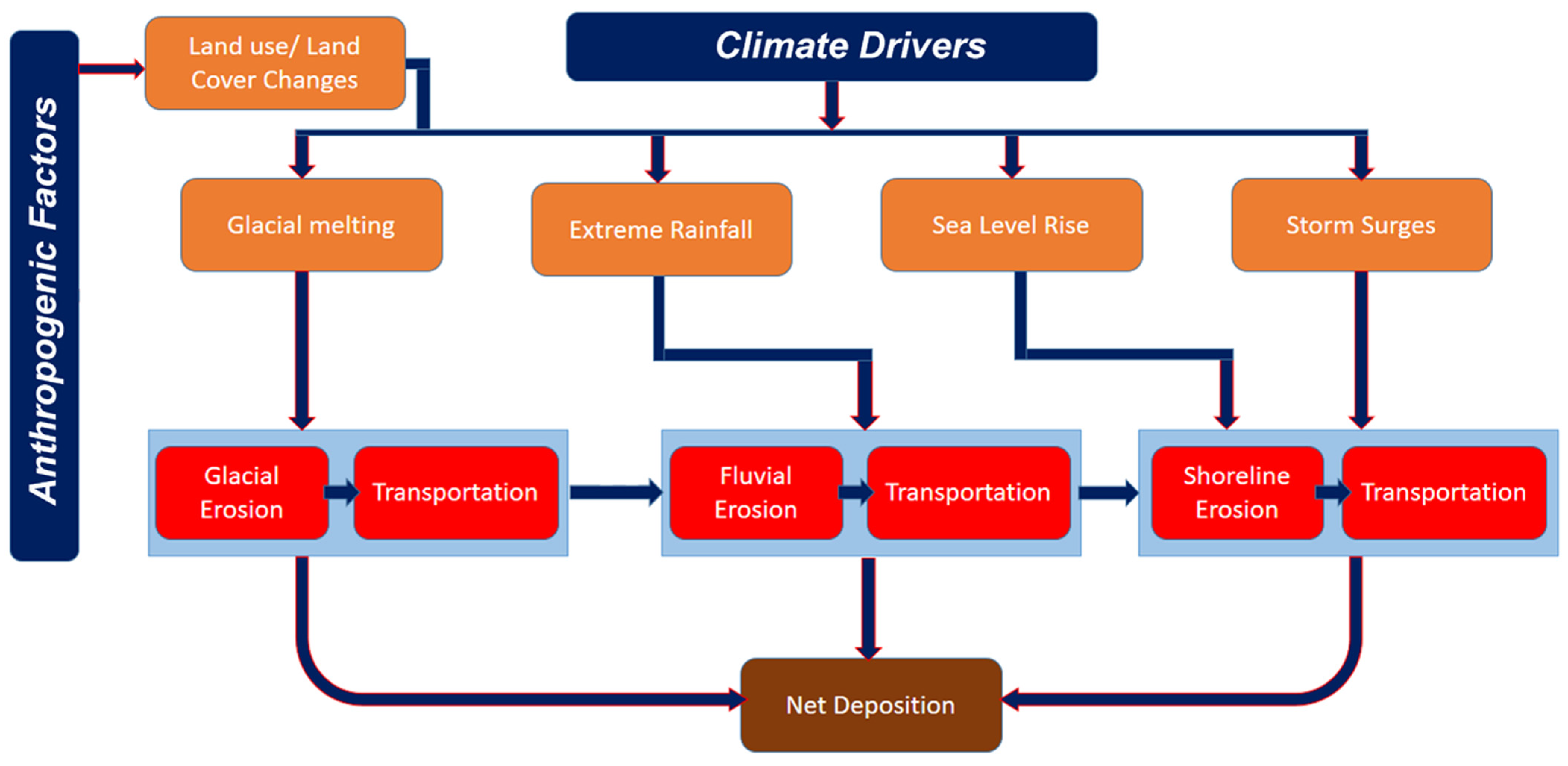
In the current era of climate change, sediment pathways (
Figure 1) are being altered by the intensification of the hydrological cycle, changes in storm frequency and intensity, glacier retreat, permafrost thaw, and rising sea levels [
17]. These extreme threshold-controlled drivers are rapidly promoting extreme sediment delivery rather than steady transport, producing abrupt geomorphic changes during floods, cyclones, landslides, and coastal storm events. At the same time, anthropogenic interventions, including dams, river bank stabilisation, land-use change, and sand mining, also fragment sediment connectivity and can hinder sediment supply from source to downstream sinks [
18,
19]. As a result, the global sediment budget is undergoing rapid reorganisation in the Anthropocene, with direct consequences for delta sustainability, coastal erosion, reservoir longevity, and long-term carbon burial [
18,
19].
Even though process-based sediment transport modelling has advanced substantially, the important limitations in this field involve existing modelling approaches being environment-specific, data-limited, and often difficult to scale from event timescales to multi-decadal climate assessments [
20,
21]. Many models simplify cohesive sediment processes, face challenges with cross-environment coupling (river–estuary–coast–shelf), and lack robust validation datasets spanning long periods and diverse geomorphic contexts [
22]. Meanwhile, remote sensing and AI/ML methods are rapidly emerging as powerful complements to numerical models. These tools offer new opportunities for model parametrization, addressing uncertainty, and near-real-time monitoring, yet their integration into climate-responsive sediment frameworks remains uneven.
Although numerous review articles have examined sediment transport processes, numerical modelling techniques, remote sensing applications, or artificial intelligence individually, relatively few studies critically evaluate how these complementary approaches can be integrated to support regional sediment assessment under changing climatic conditions [
15,
16,
19]. Existing reviews also rarely provide transparent and reproducible comparisons of widely used modelling systems or systematically examine how recent research trends support future methodological development. Consequently, researchers and practitioners continue to face uncertainty when selecting appropriate modelling frameworks for different geomorphic settings, climate scenarios, and management objectives.
To address these limitations, the present study reviews how existing sediment transport frameworks and modelling systems incorporate climate-sensitive drivers and whether they are capable of representing evolving environmental conditions and climate responses. In this context, climate change is treated as a modifying boundary condition that affects sediment processes through measurable physical mechanisms, including altered hydrological extremes, intensified coastal storms, changing sediment supply, glacier retreat, and sea-level fluctuations.
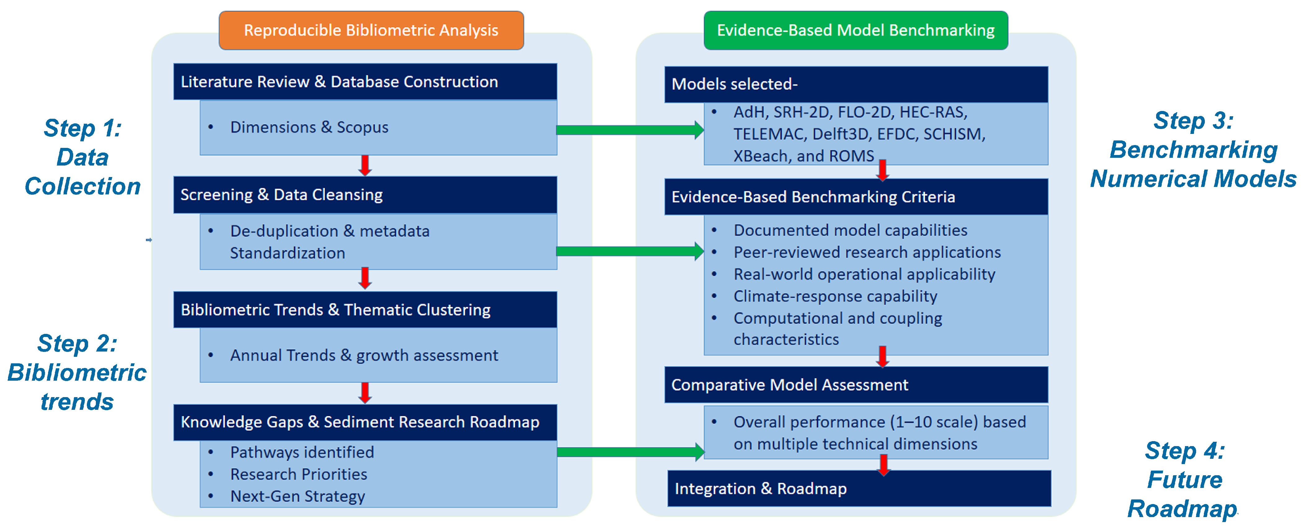
In order to achieve its goals the study involves following steps: (i) a critical synthesis of process-based numerical modelling across fluvial, estuarine, coastal, and marine environments; (ii) a reproducible bibliometric analysis of sediment transport research published between 2000 and 2026 to identify thematic evolution and emerging research directions; and (iii) a transparent benchmarking framework for evaluating major sediment transport models according to hydrodynamic capability, sediment-process representation, morphodynamic functionality, climate-forcing adaptability, computational performance, validation maturity, scalability, and community adoption. Rather than proposing a universal modelling solution, the benchmarking framework is intended to support informed model selection by identifying the strengths, limitations, and most appropriate application domains of different modelling systems.
Accordingly, this review provides four integrated contributions. First, it establishes a climate-responsive source-to-sink perspective that links sediment dynamics across traditionally separate geomorphic environments. Second, it introduces a transparent and reproducible benchmarking methodology for evaluating widely used sediment transport models. Third, it integrates bibliometric evidence with technical model assessment to identify emerging research priorities and methodological gaps. Finally, it proposes an evidence-based research roadmap. The roadmap aims to outline future directions for integrating numerical modelling, Earth observation, and artificial intelligence to support next-generation sediment transport assessment under changing environmental conditions.
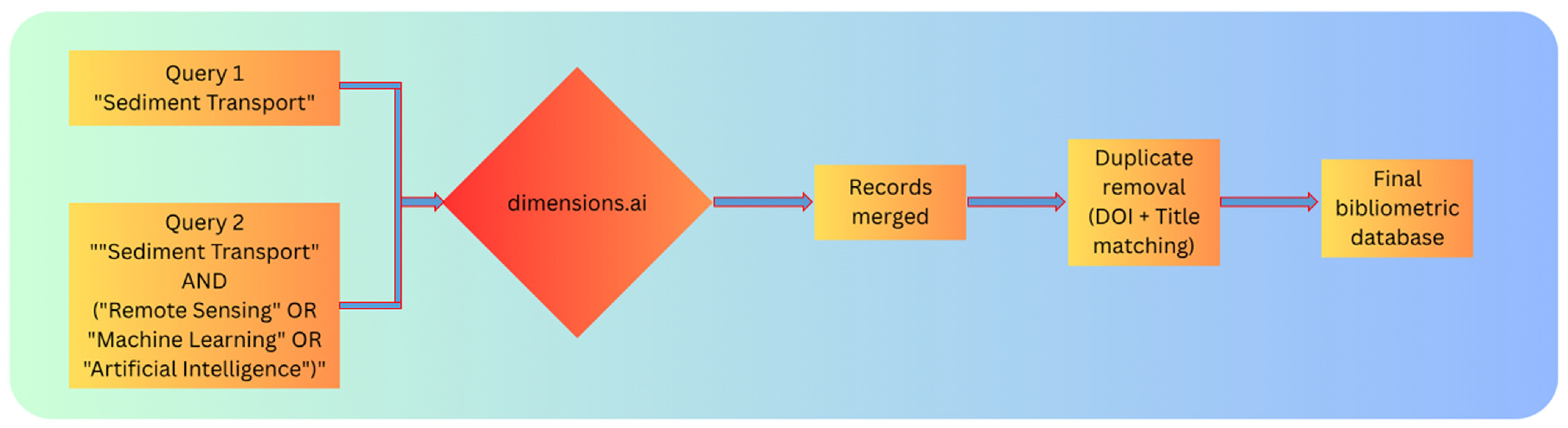
The integrated perspective developed in this review requires a transparent and reproducible methodology capable of combining technical evaluation with evidence synthesis. Accordingly, the following section outlines the structured review design, including the literature retrieval strategy, bibliometric workflow, benchmarking protocol, and evaluation criteria used to compare sediment transport models and identify emerging research directions. Establishing these procedures at the outset ensures that the subsequent analyses are reproducible, internally consistent, and directly linked to the evidence supporting the conclusions and proposed research roadmap.
3. Review of Regional Sediment Budget and Climate Influence
The sediment budget, which is a fundamental component of Earth-surface processes, links tectonics, climate, geomorphology, and biogeochemical cycles. At a large scale, the sediment budget represents the balance between sediment production, transport, storage, and deposition across the land–ocean continuum [
43]. Traditionally, sediment budgets were often assumed to be quasi-stationary over long timescales; however, increasing evidence indicates that this equilibrium has been substantially altered during the Anthropocene due to the combined influence of climate change and human interventions [
18,
19,
44].
Climate change has emerged as a dominant driver influencing sediment generation and transfer by modifying precipitation regimes, runoff seasonality, cryospheric processes, vegetation cover, and sea level [
45,
46]. Concurrently, anthropogenic activities—particularly dam construction, land-use change, river engineering, and sand mining—have disrupted sediment connectivity and altered sediment fluxes in many basins more rapidly than climate forcing alone [
19,
47]. Understanding how the sediment budget is responding to these interacting pressures is essential for predicting future landscape evolution, managing river basins, and sustaining coastal and deltaic environments under climate stress.
Sediment dynamics, which involve the processes of erosion, entrainment, transport, and deposition of sediment particles driven primarily by fluid motion [
1], depend on sediment properties (grain size, density, cohesion, settling velocity) and transport conditions (flow velocity, turbulence, shear stress, stratification) [
6,
7]. Under a changing climate, sediment transport is increasingly governed by nonlinear thresholds and extreme-event dominance, which complicates prediction and challenges traditional modelling assumptions.
3.1. Influence of Climate on the Regional Sediment Budget
At a regional scale, the conceptual framework of sediment budget can be expressed in a simplified form as [
48]
This conceptual balance integrates interconnected components operating across spatial scales: (a) Sediment sources: Weathering and erosion from hillslopes, floodplains, glaciers, permafrost terrains, and deserts provide sediment to transfer systems. (b) Transfer systems: Rivers, debris flows, coastal currents, and gravity-driven marine flows transport sediment from source areas toward sinks. (c) Temporary storage: Sediment may be stored for variable durations in floodplains, terraces, lakes, reservoirs, estuaries, and continental shelves. (d) Final sinks: Major sinks include deltas, deep-sea fans, abyssal plains, and ocean basins.
Climate exerts first-order control on sediment production and transport through precipitation, temperature, runoff variability, and storm climatology (
Figure 4), while tectonics governs long-term sediment supply through uplift, relief generation, and basin-scale gradients [
49]. Under the perceived climate change, with increasing intensification of extreme events, the sediment budget becomes increasingly nonlinear and episodic, with stronger dependence on the extremes (e.g., flood pulses, cyclone-driven resuspension, and glacial outburst floods).
Keeping in view the role of climate on source-to-sink sediment transport, the current study discusses climate controls and anthropogenic influence on sediment production and flux across geomorphic environments in the following sections.
3.2. Climate and Anthropogenic Impacts Across Geomorphic Environments
In recent decades, accelerated climate change and intensified human activities have significantly altered sediment fluxes at regional to global scales [
19,
47,
49]. Changes in precipitation intensity, glacier retreat, permafrost thaw, sea-level rise, and hydrological extremes are reshaping erosion–deposition dynamics, while dams, land-use change, and river regulation have disrupted natural sediment continuity. As a result, many depositional environments—including deltas and coastal plains—are experiencing sediment deficits that increase vulnerability to subsidence, flooding, salinity intrusion, and shoreline retreat.
3.2.1. Precipitation Variability and Extreme Events
Climate change is believed to intensify the hydrological cycle and increase the frequency of short-duration, high-intensity rainfall events [
45]. These extremes amplify hillslope erosion, landsliding, channel incision, and bank failure, producing pulsed sediment delivery rather than steady transport. In monsoon-dominated and tropical regions, sediment flux is increasingly event-driven, with a small number of extreme storms contributing disproportionately to annual sediment yield [
50].
3.2.2. Cryosphere Dynamics
Glacier retreat and permafrost thaw are emerging as major sediment sources in high-latitude and high-altitude environments [
46,
51]. Glacial debuttressing increases slope instability, while meltwater increases sediment transport efficiency and promotes sediment pulses into proglacial river systems. Thawing permafrost releases previously frozen mineral sediment and organic carbon, influencing both sediment budgets and carbon cycling. These changes introduce new sediment sources and modify seasonal sediment delivery patterns.
3.2.3. Vegetation and Land-Cover Changes
Climate-driven shifts in vegetation zones affect soil cohesion, infiltration, and runoff generation. Drought-induced vegetation loss increases susceptibility to water and wind erosion, while greening in some regions may temporarily stabilise soils [
52,
53,
54]. This spatial heterogeneity means sediment responses to climate forcing are highly region-specific and depend on interactions between climate variability, land cover, and geomorphic sensitivity including the factor of wildfires, landslides and other natural disasters, as also increased potential of sediment volumes and momentum. For example: debris flow can be significantly higher in momentum that “regular” flooding.
3.2.4. Anthropogenic Modification of the Regional Sediment Budget
Human activities now rival or exceed natural climatic controls on sediment flux. Large dams trap substantial fractions of riverine sediment, reducing sediment delivery to deltas and coasts and accelerating sediment starvation [
19,
47]. River training, embankments, channelization, and sand mining further disrupt sediment continuity, often causing channel incision, bank instability, and altered floodplain deposition [
18,
19,
47]. Climate-driven changes in runoff and sediment yield interact with these modifications, complicating predictions of future sediment supply and sink sustainability.
3.3. Source-to-Sink Connectivity Under Climate Change
A robust regional sediment transport assessment requires explicit treatment of source-to-sink connectivity, where sediment produced in uplands must pass through transfer systems and storages before reaching downstream sinks [
55]. Climate change modifies not only sediment production but also delivery efficiency by altering flood frequency, transport capacity, vegetation buffering, and coastal hydrodynamics [
56]. Meanwhile, anthropogenic fragmentation (dams, reservoirs, channelization) creates discontinuities that decouple sediment sources from sinks [
18,
19,
47].
Consequently, climate change can produce contrasting regional responses: some basins may experience increased sediment yields due to extreme rainfall and cryosphere melt, while others experience reduced downstream sediment delivery due to trapping, altered seasonality, and sediment management interventions. This connectivity-based perspective is essential for understanding delta vulnerability, coastal retreat, and long-term changes in shelf and deep-sea sedimentation patterns.
3.4. Challenges in Assessment of Sediment Dynamics Under Climate Change
From the previous discussions on climate and anthropogenic controls on sediment dynamics it is apparent that regional sediment transport under changing climate is a key issue for proper assessment of coastal vulnerabilities. For instance, deltas and coastal plains represent critical sediment sinks that are highly sensitive to reduced sediment supply and sea-level rise. Climate change can exacerbate delta subsidence and vulnerability through increased flooding, salinity intrusion, and reduced overbank deposition [
57]. Reduced fluvial sediment supply combined with stronger wave climates and rising sea level accelerates shoreline erosion and sediment redistribution along coasts [
58]. On continental shelves, sediment starvation can alter nearshore morphodynamics, while changes in sediment flux and grain-size distribution influence turbidity current activity and deep-sea fan development [
59].
Numerical modelling has become a central tool for understanding and predicting sediment transport across rivers, estuaries, coasts, shelves, and deep-sea environments. Sediment transport models typically couple hydrodynamic solvers (flow, turbulence, waves, and density stratification) with sediment modules representing erosion, entrainment, transport, deposition, and bed evolution [
2,
3,
4,
5,
6,
7].
Nevertheless, major challenges in assessment of these vulnerabilities due to regional sediment dynamics under climate change is primarily related to [
60]: (a) a shift from steady to episodic sediment delivery; (b) increasing dominance of extreme events in sediment budgets; (c) decoupling of sediment production and delivery due to human interventions; (d) enhanced contributions from cryospheric and permafrost regions, and (e) growing sediment deficits in deltas and coastal zones.
Although sediment transport modelling has progressed toward more integrated approaches, comprehensive prediction of future hazards, sustainability, and ecosystem impacts under changing climate requires models capable of incorporating multi-scale processes and coupled forcing (hydrology–ocean–climate) [
8,
9,
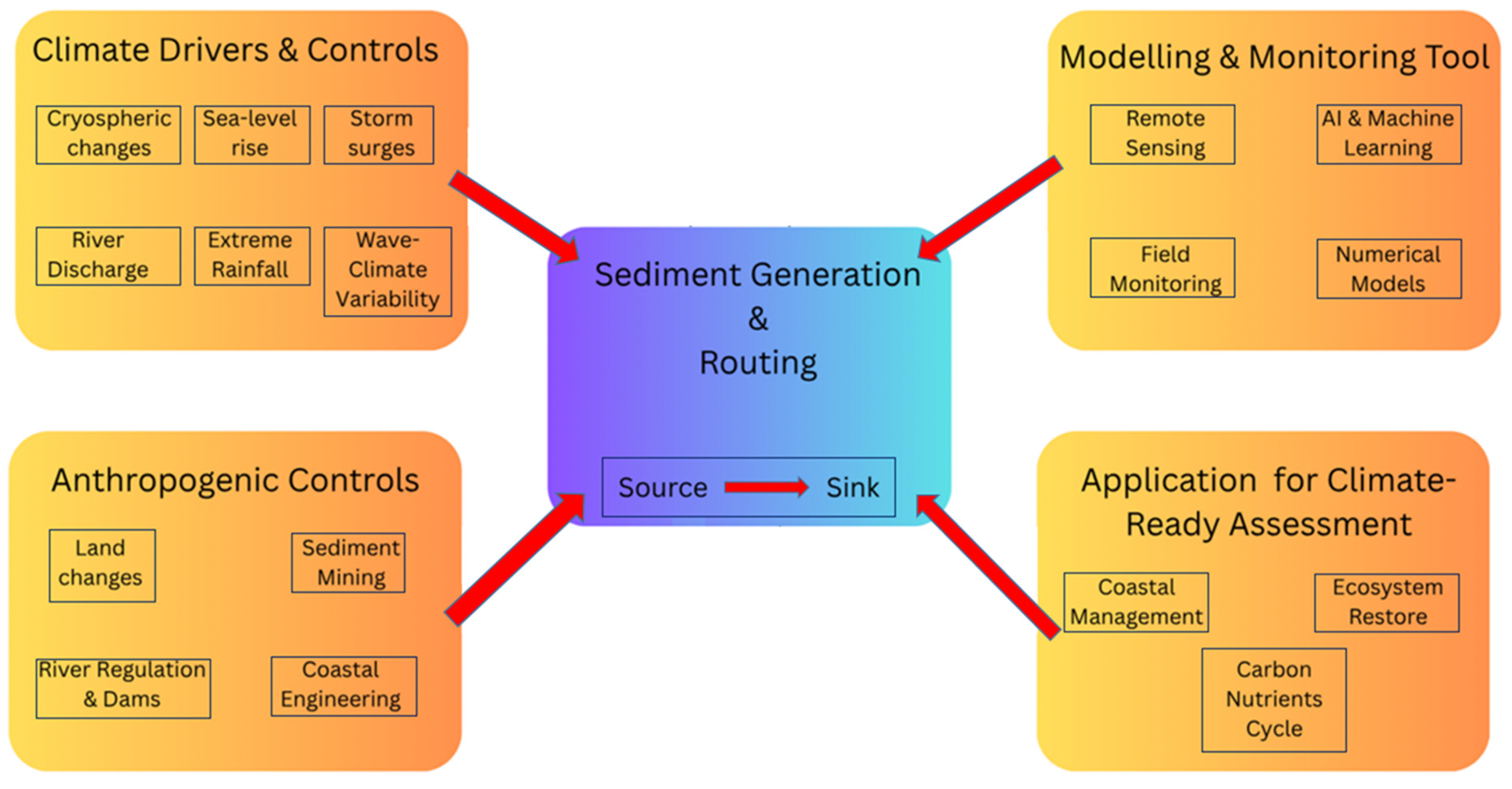
61]. However, differences in required spatial/temporal resolution, sediment parameterization, and boundary conditions remain major barriers. Looking at the inherent nature of the problem, the following sections of this review adopt the integrated conceptual framework (
Figure 5) linking climate drivers, sediment processes, modelling/monitoring tools, and applications to support climate-responsive regional sediment transport assessment.
4. State-of-the-Art Numerical Modelling of Sediment Transport
As has already been observed in previous sections, sediment transport modelling faces additional challenges due to non-stationary forcing, event-driven sediment pulses, and altered sediment connectivity driven by both climatic and anthropogenic factors under climate change [
60]. Therefore, climate-responsive sediment modelling must support multi-scale simulations, incorporate time-varying boundary conditions, and represent key process feedbacks across source-to-sink pathways.
This section summarises the current status of modelling approaches and highlights their strengths and limitations for regional sediment transport assessment under a changing climate.
4.1. Current Status of Sediment Transport Models
Currently, sediment transport models can be broadly classified into three categories depending on complexity, physical processes, and computational resources, modelling/research questions [
20,
62,
63].
The first category involves Empirical and Semi-Empirical Models. These models estimate sediment flux using simplified relationships between discharge, slope, shear stress, and sediment properties. These methods are computationally efficient and useful for screening-level assessments, but their predictive performance can degrade under climate change because they are often calibrated under historical conditions and may not capture non-stationary extremes, sediment supply limitations, or feedback-driven morphodynamics [
62,
64].
The second category involves Process-Based Numerical Models. Process-based models solve governing equations for hydrodynamics and sediment transport, enabling explicit representation of transport modes (bedload and suspended load), grain-size effects, and morphodynamic feedbacks. These models are widely used for engineering and Earth-surface applications and are essential for climate-driven assessment where nonlinearities and threshold responses are dominant [
20].
The third category comprises Reduced-Complexity and Hybrid Models. Reduced-complexity models simplify physics to improve computational feasibility for long-term simulations, while hybrid approaches combine physics-based modelling with machine learning to improve parameter estimation, surrogate modelling, and uncertainty reduction. These approaches are increasingly relevant for climate scenario studies that require long time horizons and ensemble simulations [
63].
The increasing complexity of contemporary sediment systems has fundamentally expanded the role of numerical modelling from a predictive engineering tool to an essential framework for understanding Earth-surface processes under changing environmental conditions. Climate-driven alterations in hydrological regimes, sediment supply, vegetation dynamics, cryospheric degradation, and human modification of river systems have transformed sediment transport into a highly interconnected and non-stationary process that cannot be adequately represented using empirical relationships or site-specific observations alone. Consequently, numerical models now serve not only to simulate sediment transport but also to investigate process interactions, evaluate future environmental scenarios, quantify uncertainty, and support evidence-based decision-making across river basins, estuaries, coastal zones, and continental shelf environments.
The evolution of numerical sediment transport modelling reflects a gradual transition from simplified one-dimensional hydraulic formulations toward fully coupled hydro-morphodynamic systems capable of representing complex feedbacks among flow dynamics, sediment transport, channel evolution, and landscape change. Modern modelling frameworks increasingly integrate hydrodynamics, multiple sediment fractions, bank erosion, bed evolution, wave–current interaction, vegetation effects, and climate-sensitive boundary conditions within unified computational environments. These advances have substantially improved the capacity to simulate sediment responses over broader spatial scales and longer temporal horizons while supporting applications ranging from flood risk assessment and reservoir sedimentation to delta evolution and coastal resilience.
Despite these advances, no individual modelling framework can comprehensively represent every process governing regional sediment dynamics. Model performance depends strongly on spatial scale, governing processes, sediment characteristics, computational requirements, data availability, and the intended management objective. High-fidelity hydro-morphodynamic models often provide detailed physical representation but require extensive calibration and computational resources, whereas simplified or empirical approaches may offer greater operational efficiency at the expense of process realism. Consequently, selecting an appropriate modelling framework has become a scientific decision that requires balancing physical complexity, computational feasibility, uncertainty, and application-specific objectives rather than simply adopting the most sophisticated available model.
This increasing diversity of modelling philosophies reflects the growing recognition that climate-responsive sediment assessment requires flexible modelling strategies capable of representing interconnected source-to-sink systems under evolving environmental conditions. Rather than seeking a universally optimal model, recent research increasingly emphasises selecting modelling frameworks according to the dominant geomorphic processes, available observations, and management questions while integrating complementary information from remote sensing, field monitoring, and data-driven analytical techniques. Understanding these contrasting modelling philosophies therefore provides the foundation for critically evaluating their respective strengths, limitations, and future development pathways.
4.2. Physical Process Representations in Sediment Transport Modelling
The reliability of any sediment transport model is primarily determined by its ability to represent the physical processes that control sediment production, entrainment, transport, deposition, and long-term landscape evolution. Under contemporary climate conditions, these processes operate within increasingly dynamic and interconnected environmental systems where changing hydrological regimes, sea-level rise, extreme events, vegetation change, and human interventions continuously modify sediment pathways. Consequently, evaluating numerical models requires consideration not only of computational performance but also of their capacity to reproduce the governing physical mechanisms that regulate sediment behaviour across multiple spatial and temporal scales.
Hydrodynamic simulation provides the foundation of sediment transport modelling because flow velocity, turbulence, water depth, shear stress, and energy gradients determine the initiation and movement of sediment particles. Accurate representation of these variables is essential for predicting erosion, deposition, and sediment redistribution under both steady and highly transient flow conditions. Climate-driven changes in flood magnitude, storm intensity, tidal dynamics, and compound flooding further increase the importance of resolving hydrodynamic variability with sufficient spatial and temporal resolution. Models capable of coupling river discharge, tidal forcing, waves, and meteorological processes therefore provide significant advantages for regional-scale applications where multiple drivers interact simultaneously.
Sediment entrainment and transport introduce additional complexity because transport behaviour depends not only on hydraulic forcing but also on grain-size distribution, sediment density, cohesion, bed composition, vegetation, and sediment availability. Although classical transport formulations remain widely applied, their predictive capability may decrease under rapidly changing environmental conditions where threshold responses, mixed sediment populations, and evolving boundary conditions dominate system behaviour. Contemporary modelling frameworks increasingly incorporate multiple sediment fractions, suspended and bed-load transport, cohesive sediment processes, and sediment exchange between channels, floodplains, estuaries, and coastal environments to improve physical realism.
Morphodynamic feedbacks represent another critical requirement for climate-responsive modelling because sediment transport continuously modifies channel geometry, floodplain topography, estuarine morphology, and coastal landscapes, which subsequently alter hydraulic behaviour and future sediment transport pathways. This bidirectional interaction between flow and morphology is particularly important when evaluating long-term responses to climate change, reservoir sedimentation, delta evolution, shoreline migration, and river restoration. Models capable of dynamically coupling hydrodynamics with bed evolution therefore provide greater capacity to simulate cumulative environmental change than approaches that assume fixed channel geometry.
Increasing attention is also being directed toward representing coupled environmental processes that extend beyond traditional hydraulic formulations. Wave–current interactions, vegetation dynamics, groundwater exchange, sediment biogeochemistry, glacier-derived sediment supply, and human interventions such as dam regulation and river engineering increasingly influence regional sediment budgets. Furthermore, uncertainty associated with climate projections, boundary conditions, and observational limitations has highlighted the importance of ensemble simulation, sensitivity analysis, data assimilation, and probabilistic model evaluation. These developments indicate that future sediment transport models will be judged not solely by computational sophistication but by their ability to integrate diverse physical processes while maintaining transparency, robustness, and reproducibility across changing environmental conditions.
Collectively, these process requirements establish the scientific criteria against which modern numerical modelling frameworks should be evaluated. The following subsection therefore reviews the principal modelling philosophies that have emerged to address these increasingly complex process interactions and examines their respective strengths, limitations, and domains of applicability for climate-responsive regional sediment assessment.
4.2.1. Bed Shear Stress and Entrainment Thresholds
Sediment entrainment is controlled by bed shear stress and critical thresholds, commonly represented through Shields-type formulations [
3,
4,
5,
65]. Sediment transport occurs only when the flow exceeds a critical shear stress (τ
ce) for erosion. Initially, particle mobilisation occurs in patches, but increases rapidly once this threshold is surpassed. For cohesive sediments, critical shear stress varies substantially depending on consolidation state, clay mineralogy, organic matter content, and salinity. Reported erosion thresholds commonly range from approximately 0.05 to 2 N m
−2, although higher values may occur in strongly consolidated beds [
2].
For non-cohesive sediments, critical shear is estimated as [
2]
where
θ = Shield’s parameter
ρs,
ρ = sediment and fluid densities
g = acceleration due to gravity
d = particle diameter.
Suspension depends on settling velocity (w). If particles are finer than 200 μm, the critical stress for suspension equals that for erosion. For coarser particles, suspension occurs only when shear stress exceeds a higher critical value (τ
cs), which can be estimated as [
3,
4,
5,
65]
where
w = settling velocity,
d* = nondimentional particle diameter.
Cheng [
65] provides the settling velocity formulation:
where
is the kinematic fluid viscosity.
The ratio of suspended to total sediment load (q
s/q
t) is expressed as [
66]
where
µ is the shear velocity.
The erosion flux of the suspended load (
Es,k) and bedload (
Eb,k) for the
kth class is estimated by multiplying the erosion flux of that class by
qs/qt and 1 −
qs/qt, respectively. Therefore, mathematically we can write
where
fk denotes the mass fraction of sediments for the
kth class.
Under climate change, intensification of floods and storms increases exceedance frequency of entrainment thresholds, shifting sediment transport regimes toward episodic, high-magnitude events.
4.2.2. Bedload and Suspended Load Transport
Bedload transport is typically represented using empirical transport formulas, while suspended load is solved using advection–diffusion approaches [
3,
4,
5]. In climate applications, suspended sediment dynamics are particularly important because extreme rainfall and floods can dramatically increase suspended sediment concentration, turbidity, and downstream deposition patterns.
4.2.3. Cohesive Sediment Dynamics
Cohesive sediments (silt–clay) introduce complexity due to flocculation, consolidation, and erosion resistance that varies with bed history and salinity [
2]. Many models simplify cohesive processes, which can be problematic for estuaries, deltas, and nearshore environments where fine sediment dominates and climate-driven changes in stratification and turbulence strongly affect transport.
4.2.4. Morphodynamic Feedbacks
Morphodynamic feedbacks link bed evolution with hydrodynamics (
Section 2.2.3) [
67,
68]. Bed changes can modify flow pathways, sediment transport capacity, and hazard exposure. Under climate change, these feedbacks can amplify shoreline retreat, channel migration, and delta instability, making morphodynamic coupling essential for long-term assessment.
4.3. Model Performance Across Geomorphic Environments
The rapid evolution of sediment transport modelling has produced a diverse range of numerical approaches that differ not only in computational implementation but also in their underlying scientific philosophy. Rather than representing successive generations of increasingly sophisticated software, contemporary modelling frameworks have evolved to address distinct geomorphic processes, spatial scales, data availability, and management objectives. Consequently, selecting an appropriate modelling approach requires understanding the conceptual assumptions, strengths, and limitations of each modelling philosophy rather than simply comparing individual software packages.
The predictive capability of sediment transport models depends not only on their computational architecture but also on the geomorphic environments in which they are applied. Rivers, reservoirs, floodplains, estuaries, deltas, and coastal systems differ fundamentally in their dominant hydrodynamic controls, sediment characteristics, spatial scales, and process interactions. Consequently, model performance cannot be evaluated independently of environmental context. A framework that performs exceptionally well in one setting may require substantial modification when applied to another because each environment presents distinct physical challenges and modelling objectives.
4.3.1. Fluvial Sediment Transport Modelling
Rivers represent the primary transfer pathway for sediment from upland sources to coastal sinks. Fluvial environments remain the most extensively modelled sediment systems owing to their direct relevance for flood hazards, river engineering, bank erosion, sediment yield estimation, and watershed management. In these systems, model performance depends largely on accurate representation of flow hydraulics, sediment entrainment, suspended and bed-load transport, channel migration, and floodplain connectivity.
Fluvial sediment transport models are widely used to simulate erosion, transport, deposition, and channel evolution across a range of scales [
69,
70]. Process-based models have demonstrated strong predictive capability where high-resolution topographic and hydrological datasets are available, particularly for simulating flood-induced sediment redistribution and long-term channel adjustment. However, uncertainties associated with sediment supply, bank failure mechanisms, vegetation interactions, and extreme-event dynamics continue to limit prediction accuracy under increasingly variable climatic conditions.
Reservoirs introduce additional complexities because sediment transport is governed by rapidly changing flow velocities, sediment trapping efficiency, density currents, operational water-level fluctuations, and reservoir management practices. Accurate simulation therefore requires simultaneous representation of inflow dynamics, particle settling, resuspension, and long-term storage evolution. Although many hydrodynamic models successfully reproduce reservoir circulation, predicting sediment accumulation over decadal timescales remains challenging because deposition patterns are highly sensitive to operational strategies, sediment characteristics, and evolving watershed conditions.
There are three primary categories of fluvial hydrodynamic models:
The first category is One-Dimensional (1D) River Models. These 1D models (e.g., HEC-RAS in sediment mode) are efficient tools for long river networks and management applications [
71]. They are widely used for flood–sediment studies, reservoir sedimentation assessment, and channel stability analysis [
72]. However, 1D approaches have limited capacity to represent lateral processes such as bar formation, bank erosion, and complex bifurcations, which may become increasingly important under changing flow regimes.
The second category is Two-Dimensional (2D) Depth-Averaged River Models. These 2D models resolve spatial patterns in flow and sediment transport and can simulate channel migration, bar dynamics, and floodplain exchange more realistically [
73,
74,
75]. These models are suitable for climate-driven floodplain sedimentation studies and event-scale hazard assessments.
The third category is Three-Dimensional (3D) River Models. These 3D models are required when vertical structure and turbulence-driven processes dominate, such as in deep pools, confluences, and density-stratified flows [
74,
75]. Although computationally expensive, 3D modelling is increasingly used for high-resolution process understanding and validation of simplified models.
4.3.2. Estuarine and Deltaic Sediment Transport Modelling
Estuarine and deltaic systems represent some of the most demanding environments for sediment transport modelling because they integrate river discharge, tidal forcing, wave action, salinity gradients, cohesive sediment behaviour, and complex morphological feedbacks within relatively confined spatial domains [
76]. These interacting processes generate highly nonlinear sediment dynamics that are difficult to reproduce using simplified hydraulic formulations.
Fully coupled hydro-morphodynamic models generally provide the most robust framework for representing these environments because they simultaneously resolve hydrodynamic forcing, sediment exchange, and morphological evolution. These environments are highly sensitive to climate change due to sea-level rise, storm surge intensification, and altered river discharge. Nevertheless, uncertainties associated with turbulence closure, sediment flocculation, vegetation dynamics, and long-term morphological adjustment remain important limitations, particularly under accelerating sea-level rise and changing storm regimes.
The estuary and deltaic models can be classified into two categories.
The first category is Estuarine Turbidity Maxima and Stratification. Sediment trapping and resuspension in estuaries are strongly controlled by stratification, tidal mixing, and residual circulation [
77]. Climate-driven changes in freshwater discharge and sea-level rise can shift turbidity maxima location and intensity, influencing navigation, water quality, and ecosystem functioning.
The second category is Delta Sustainability Under Sediment Deficit. Many deltas face sediment starvation due to upstream dams and reduced sediment supply [
78]. When combined with sea-level rise and subsidence, this accelerates delta retreat and flood vulnerability. Climate-responsive delta modelling requires coupled representation of river inflow, sediment supply, tidal forcing, wave climate, and morphological adaptation.
4.3.3. Coastal Sediment Transport and Shoreline Morphodynamics
Coastal and continental shelf environments further increase modelling complexity by introducing multidirectional wave–current interactions, storm surges, shoreline migration, offshore sediment exchange, and large-scale sediment redistribution driven by meteorological forcing. These systems require integration of hydrodynamic, wave, and sediment transport processes across multiple spatial scales while accounting for highly dynamic boundary conditions. Advances in wave-resolving and coupled coastal models have substantially improved simulation capability, yet reliable prediction of long-term coastal evolution continues to depend on the availability of high-quality bathymetric observations, sediment datasets, and continuous environmental monitoring.
Models such as XBeach and Delft3D are widely applied for storm erosion, barrier overwash, inlet dynamics, and beach nourishment planning [
67,
79,
80]. Coastal sediment transport models can be divided into two groups.
The first group includes Storm-Driven Sediment Transport. Extreme storms can dominate coastal sediment budgets through episodic erosion, dune scarping, and overwash deposition [
81]. Climate change may increase storm intensity and compound impacts through higher sea levels, making storm-resolving models critical for future hazard projections.
The second group is Longshore Transport and Shoreline Evolution. Longshore sediment transport controls shoreline stability over seasonal to decadal timescales [
82]. Climate-driven shifts in wave climate and sea level can modify longshore transport gradients, altering erosion hotspots and sediment accumulation zones.
4.3.4. Shelf and Deep-Sea Sediment Transport Modelling
Beyond the nearshore zone, sediment transport continues across continental shelves and into deep-sea basins through suspension, resuspension, and gravity-driven flows such as turbidity currents [
83,
84]. The shelf and deep-sea sediment transport models are of two categories.
The first category is Shelf Resuspension and Sediment Redistribution. Shelf sediments can be resuspended by storms and strong currents, influencing turbidity, benthic habitats, and sediment delivery to deeper environments [
77,
85]. Climate change may alter storm climatology and stratification, affecting resuspension thresholds and sediment dispersal patterns.
The second category is Turbidity Currents and Deep-Sea Deposition. Turbidity currents are important for deep-sea sediment transport and hazard assessment (e.g., submarine cable risk). Modelling these flows requires careful treatment of density stratification, sediment settling, and bed interaction [
86]. While specialised models exist, coupling deep-sea processes into regional sediment assessment remains a major challenge.
4.4. Emerging Challenges and Future Directions in Climate-Responsive Sediment Modelling
For regional sediment transport assessment under a changing climate, numerical models must increasingly support [
44,
87,
88]:
Non-stationary forcing: Time-varying discharge, sea-level rise, changing storm climatology.
Extreme-event dominance: Episodic sediment pulses and threshold exceedance.
Cross-environment coupling: River–estuary–coast–shelf connectivity.
Long-term morphodynamics: Decadal-scale bed evolution and shoreline change.
Uncertainty quantification: Ensemble modelling, sensitivity analysis, and data assimilation.
Scalable computation: HPC and cloud-ready workflows for large domains and long simulations.
Despite remarkable advances in computational hydrodynamics and morphodynamic simulation, accurately predicting sediment transport under rapidly changing environmental conditions remains one of the most challenging problems in Earth-system science. Increasing hydroclimatic variability, compound hazards, accelerated landscape modification, and growing anthropogenic intervention have exposed limitations in many existing modelling frameworks, particularly those originally developed under assumptions of stationarity [
56,
89]. Consequently, future progress depends not only on improving numerical algorithms but also on developing modelling strategies capable of representing increasingly dynamic and interconnected sediment systems.
One of the most significant challenges is the representation of multi-scale process interactions. Sediment transport is governed simultaneously by local hydraulic conditions, watershed-scale sediment connectivity, seasonal hydrological variability, and long-term geomorphic evolution. Integrating these interacting processes within a single modelling framework remains computationally demanding because the governing spatial and temporal scales differ by several orders of magnitude. Future models must therefore balance physical realism with computational efficiency while maintaining numerical stability across highly variable environmental conditions.
Another persistent limitation is the incomplete representation of complex sediment processes. Although considerable progress has been achieved in simulating non-cohesive sediment transport, uncertainties remain in modelling cohesive sediment behaviour, sediment flocculation, bank failure mechanisms, vegetation–sediment interactions, glacier-derived sediment supply, and sediment biogeochemistry. These processes become increasingly important under climate change because they strongly influence sediment availability, transport thresholds, and long-term landscape evolution. Improving their representation will require closer integration between field observations, laboratory experiments, and numerical model development.
Data availability and model validation continue to constrain predictive reliability. High-resolution topographic data, continuous hydrological observations, sediment characteristics, bathymetric surveys, and long-term morphodynamic records remain unavailable for many river basins and coastal environments, particularly within developing regions. These limitations complicate model calibration and increase uncertainty in future projections. Expanding open environmental data infrastructures, integrating multi-source Earth observation products, and strengthening long-term monitoring programmes will therefore be essential for improving model credibility and transferability across diverse environmental settings.
Artificial intelligence is increasingly transforming sediment transport research, although its greatest potential lies in complementing rather than replacing process-based numerical modelling [
90]. Machine learning algorithms have demonstrated considerable capability for parameter optimisation, surrogate modelling, uncertainty quantification, data assimilation, and rapid prediction, while physics-informed neural networks offer promising opportunities to combine observational learning with governing physical principles. Future research should therefore prioritise hybrid computational frameworks in which process-based models provide physical consistency, and AI enhances computational efficiency, adaptive calibration, and predictive scalability.
The emergence of digital twins, cloud computing, high-performance computing, real-time environmental sensing, and autonomous observation systems further expands the scope of regional sediment assessment. These technologies enable continuous integration of numerical simulation with near-real-time observations, creating opportunities for adaptive forecasting, early-warning systems, infrastructure management, and climate-responsive decision support. Nevertheless, their successful implementation depends on transparent uncertainty assessment, interoperable modelling architectures, reproducible computational workflows, and effective communication between hydrologists, geomorphologists, remote sensing specialists, computer scientists, and decision-makers.
Collectively, these challenges indicate that the future of sediment transport modelling lies not in the development of a universally superior numerical model but in constructing integrated modelling ecosystems capable of combining process-based simulation, Earth observation, artificial intelligence, uncertainty analysis, and scalable computational infrastructures. Evaluating how existing modelling frameworks contribute to this emerging paradigm requires a systematic and transparent comparison of their respective capabilities. The following section therefore develops an evidence-based benchmarking framework to assess the performance, strengths, and limitations of widely used sediment transport models across multiple technical and climate-related evaluation criteria.
5. Benchmarking of Sediment Transport Models for Climate-Driven Regional Assessment
The preceding sections demonstrate that contemporary sediment transport modelling has evolved into a diverse landscape of process-based, empirical, and hybrid computational approaches, each designed to address specific environmental conditions, spatial scales, and management objectives. This diversity represents an important scientific strength because no single modelling philosophy can simultaneously maximise physical realism, computational efficiency, spatial scalability, data accessibility, and operational flexibility across all geomorphic environments. Consequently, selecting an appropriate modelling framework has become increasingly complex, particularly for climate-responsive regional sediment assessment where interacting hydrological, geomorphological, and environmental processes must be represented within non-stationary conditions.
Although numerous studies evaluate the performance of individual numerical models within specific case studies, direct comparison among modelling systems remains challenging because published assessments often employ different datasets, calibration strategies, evaluation metrics, spatial domains, and modelling objectives. As a result, reported model performance cannot be directly extrapolated across environments or interpreted as universal evidence of model superiority. A transparent comparative framework is therefore required to evaluate the relative capabilities of widely used modelling systems according to consistent technical and climate-related criteria.
Accordingly, this section presents a structured benchmarking protocol designed to compare major sediment transport models in terms of (i) climate-scenario readiness and (ii) overall performance, with emphasis on reproducibility and interpretability.
5.1. Scientific Rationale for Comparative Benchmarking
The objective of the benchmarking framework developed in this review is not to identify a universally optimal numerical model but to provide a structured and reproducible comparison of modelling capabilities relevant to climate-responsive regional sediment assessment. The evaluation therefore considers multiple complementary dimensions, including hydrodynamic representation, sediment-process simulation, morphodynamic functionality, adaptability to climate forcing, computational performance, validation maturity, scalability, and practical applicability. Together, these criteria provide a balanced assessment of both scientific capability and operational suitability while recognising that different models are designed to address different classes of sediment transport problems.
Accordingly, the benchmarking results should be interpreted as comparative indicators that support evidence-based model selection rather than absolute measures of model quality. This perspective recognises that the suitability of any modelling framework ultimately depends on the interaction between process representation, environmental complexity, data availability, computational resources, and the specific scientific or management questions being addressed.
Benchmarking serves three main purposes in the context of climate-driven sediment transport assessment: (a) Model selection guidance: To identify suitable models for specific environments and climate forcing scenarios (e.g., sea-level rise, extreme floods, storm-driven erosion); (b) Capability comparison: To quantify differences in sediment physics representation (bedload, suspended load, cohesive sediment, morphodynamic feedbacks) and numerical design (mesh type, coupling capability); and (c) Research gap identification: To highlight limitations that constrain climate-scale assessment, including computational feasibility, uncertainty quantification, and lack of long-term validation.
5.2. Benchmarking Philosophy and Evaluation Framework
The benchmarking framework developed in this review is designed to provide a transparent, evidence-based comparison of contemporary sediment transport models rather than a ranking of universally superior modelling systems. Because numerical models are developed for different scientific objectives, geomorphic environments, and operational constraints, direct comparison using a single performance metric would oversimplify their capabilities and potentially favour one modelling philosophy over another. The evaluation therefore adopts a multi-criteria framework that recognises the complementary nature of different modelling approaches while maintaining methodological consistency across all assessed models.
The selection of benchmarking criteria was guided by the scientific requirements for climate-responsive sediment assessment established in
Section 4. Specifically, the evaluation considers the ability of each modelling framework to represent the principal physical processes governing sediment dynamics, including hydrodynamic simulation, sediment entrainment and transport, morphodynamic evolution, adaptation to climate-related forcing, computational efficiency, validation maturity, scalability across spatial domains, and practical implementation within research and management applications. Each criterion therefore represents a measurable modelling capability directly linked to the physical processes required for reliable regional sediment assessment rather than an arbitrary technical attribute.
To maximise reproducibility, model scores were assigned through systematic synthesis of published peer-reviewed literature, official technical documentation, benchmark applications, and widely reported operational performance. Rather than relying on isolated case studies, the assessment emphasises the consistency of evidence across multiple independent investigations. For every evaluation criterion, the assigned score reflects the degree to which published evidence demonstrates the capability of a modelling framework to represent the corresponding physical process or operational requirement. Consequently, the benchmarking should be interpreted as a structured synthesis of accumulated scientific evidence rather than as a subjective expert opinion.
Because the evaluated criteria differ in scientific scope and practical importance, the framework is intentionally comparative rather than absolute. Higher scores indicate stronger demonstrated capability relative to the other assessed models within the defined evaluation criteria, whereas lower scores indicate comparatively narrower applicability, greater process limitations, or reduced evidence of performance for climate-responsive regional sediment assessment. Importantly, lower comparative scores do not imply inferior scientific quality; instead, they often reflect deliberate model design for specialised environments or specific operational applications where simplified formulations provide greater efficiency or robustness than highly complex process-based systems.
The benchmarking framework therefore supports informed model selection by explicitly recognising the trade-offs among physical realism, computational demand, data requirements, operational flexibility, and environmental applicability. This perspective is particularly important for climate-responsive sediment assessment because increasing environmental complexity requires selecting modelling frameworks that are appropriate for specific scientific questions rather than assuming that one model can optimally represent all geomorphic processes and management objectives.
5.3. Comparative Evaluation of Numerical Modelling Frameworks
Benchmarking was applied to widely used and representative modelling systems that cover fluvial, estuarine, coastal, and marine sediment transport applications (
Table 4). The selected models include: AdH, SRH-2D, FLO-2D, HEC-RAS, TELEMAC, Delft3D, EFDC, SCHISM, XBeach, ROMS [
27,
28,
29,
30,
31,
32,
33,
34,
35,
36,
37,
38,
39,
40,
41,
42]. These models were selected because they are frequently applied in sediment transport studies, offer distinct numerical designs (structured vs. unstructured meshes, hydrodynamic coupling options), and collectively span a broad range of geomorphic environments relevant to regional sediment assessment.
The comparative benchmarking demonstrates that differences among contemporary sediment transport models arise primarily from variations in process representation rather than software architecture alone (
Table 5). Across all evaluated frameworks, higher comparative performance is consistently associated with the ability to represent coupled hydrodynamics, sediment transport, morphodynamic evolution, and changing environmental boundary conditions within an integrated computational environment. Consequently, benchmarking should be interpreted as an evaluation of modelling capability rather than software complexity, recognising that different frameworks are designed to address different scientific and operational objectives.
Hydrodynamic capability emerged as the most fundamental criterion because accurate simulation of flow hydraulics governs every subsequent sediment transport process. Models that solve the full shallow-water equations while accommodating complex boundary conditions, wetting and drying processes, wave–current interactions, and multidimensional flow generally demonstrated broader applicability across fluvial, estuarine, and coastal environments. Frameworks such as Delft3D and TELEMAC-MASCARET consistently exhibit strong performance because they integrate hydrodynamic simulation with sediment transport and morphological evolution within unified computational systems. By contrast, models designed primarily for one-dimensional hydraulic analysis or specialised applications often provide excellent performance within their intended operational domains but exhibit reduced flexibility when representing highly coupled regional sediment systems.
Sediment-process representation constituted the second major differentiating factor among the evaluated frameworks. Models capable of simultaneously representing suspended load, bed-load transport, mixed sediment fractions, cohesive sediment behaviour, and sediment exchange across multiple environments demonstrated substantially greater versatility than models relying on simplified transport formulations. This distinction becomes increasingly important under changing climatic conditions where evolving sediment sources, extreme hydrological events, and shifting transport thresholds require dynamic representation of sediment behaviour rather than reliance on static empirical relationships.
Morphodynamic functionality further distinguished comprehensive hydro-morphodynamic systems from models developed primarily for hydraulic prediction. Long-term simulation of channel adjustment, floodplain evolution, reservoir sedimentation, estuarine morphology, and coastal landscape change requires continuous feedback between sediment transport and bed evolution. Frameworks capable of dynamically updating topography during simulation therefore provide significant advantages for evaluating cumulative environmental change, whereas fixed-bed hydraulic models remain more appropriate for short-term engineering applications where morphological evolution is not the primary objective.
Climate adaptability represents an increasingly important benchmark criterion because future sediment assessment must operate under non-stationary environmental conditions characterised by changing precipitation regimes, sea-level rise, compound flooding, glacier retreat, and increasing anthropogenic modification of sediment pathways. Models that successfully integrate multiple hydrological and environmental drivers while maintaining numerical stability across diverse boundary conditions demonstrate greater potential for supporting climate adaptation and long-term environmental management. Conversely, frameworks developed for highly specific operational environments may require substantial modification before they can reliably simulate future climate scenarios.
Operational performance extends beyond physical process representation to include computational efficiency, scalability, validation maturity, and practical implementation. Highly detailed hydro-morphodynamic models generally provide superior process realism but often require considerable computational resources, specialised expertise, and extensive calibration datasets. Simpler hydraulic or empirical frameworks, although representing fewer physical processes, frequently offer greater operational efficiency for routine engineering assessments or data-limited applications. This trade-off highlights that model suitability depends on balancing physical complexity with computational feasibility and management requirements rather than maximising technical sophistication alone.
Overall, the benchmarking reveals a consistent scientific pattern: the highest comparative capability is achieved by modelling frameworks that integrate hydrodynamics, sediment transport, morphodynamics, and environmental forcing within unified computational environments while maintaining sufficient flexibility for application across multiple geomorphic settings. However, this observation should not be interpreted as evidence that these frameworks are universally superior. Instead, it demonstrates that comprehensive process representation becomes increasingly important as sediment assessment shifts from local engineering applications toward regional, climate-responsive environmental analysis. The benchmark scores therefore provide a structured synthesis of comparative modelling capability that supports informed model selection according to specific scientific objectives, environmental complexity, and data availability rather than promoting a single preferred modelling framework.
5.4. Scientific Interpretation of Benchmark Results
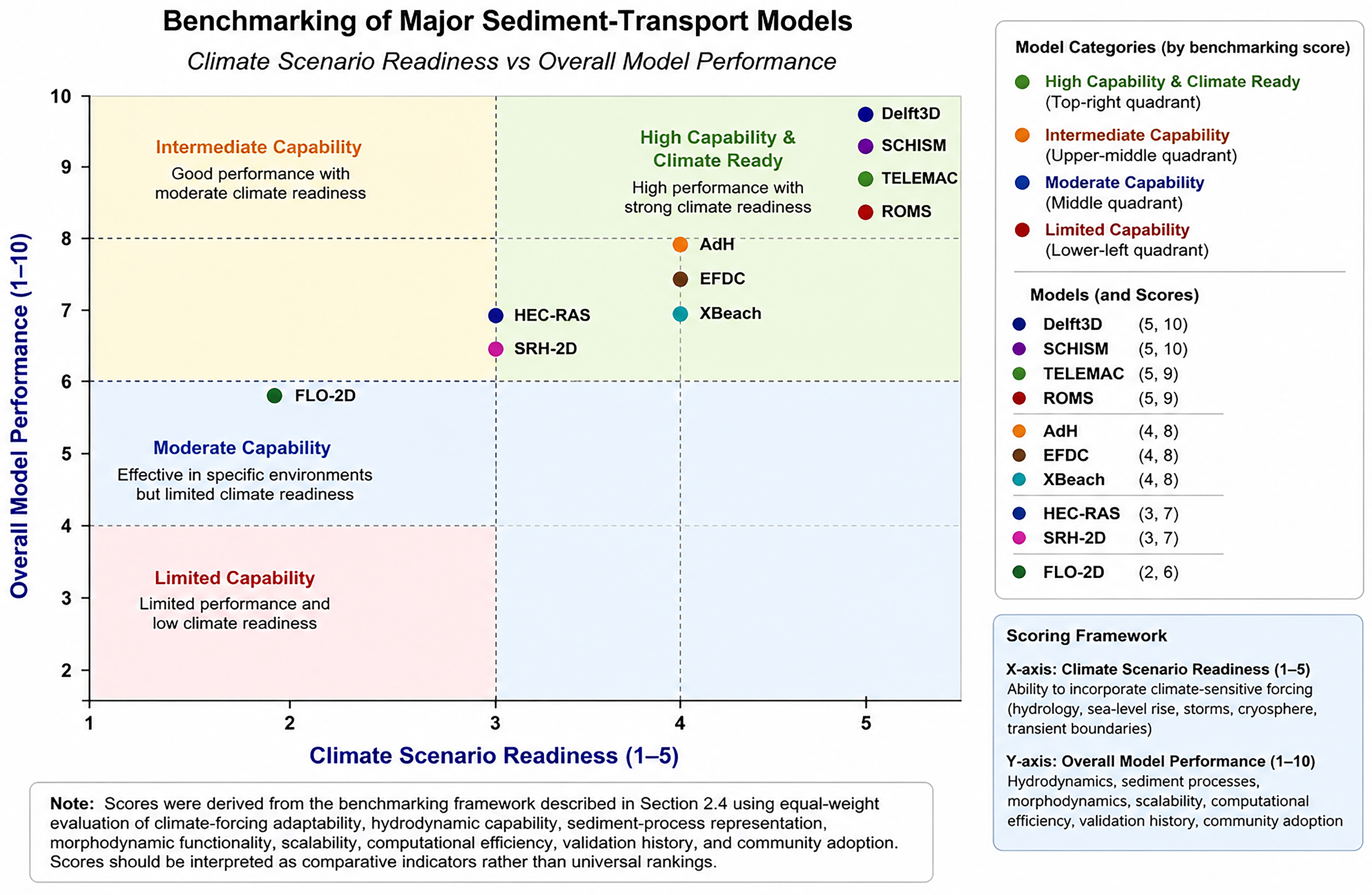
This section illustrates the results of the benchmarking framework, which includes widely applied sediment transport and hydrodynamic models, including AdH, SRH-2D, FLO-2D, HEC-RAS, TELEMAC, Delft3D, EFDC, SCHISM, XBeach, and ROMS (
Table 5).
5.4.1. General Performance Patterns
The benchmarking results reveal a clear distinction between environment-specific modelling tools and integrated climate-responsive modelling frameworks (
Figure 6). Delft3D and SCHISM achieved the highest combined scores owing to their strong hydrodynamic–sediment coupling, advanced morphodynamic capabilities, flexible grid architectures, and suitability for large-domain climate-sensitive applications. TELEMAC and ROMS also demonstrated high overall performance and climate readiness, particularly for estuarine, coastal, and shelf-scale investigations where complex interactions among hydrodynamics, sediment transport, and morphological change must be represented.
AdH, EFDC, and XBeach occupied an intermediate position because of their strong process representation within specific environmental settings and their demonstrated capability to simulate important sediment-transport processes under variable forcing conditions. HEC-RAS and SRH-2D remain among the most widely applied and operationally robust tools for riverine sediment assessment, floodplain analysis, and engineering design; however, their application to fully integrated source-to-sink and long-term climate-response studies is comparatively more limited. FLO-2D provides valuable capability for event-based flood and sediment simulations but exhibits lower climate-readiness and reduced flexibility for multi-environment applications relative to more comprehensive modelling frameworks.
The comparative evaluation further indicates that models incorporating dynamic boundary conditions, stronger morphodynamic coupling, and greater flexibility in representing multiple sediment processes generally exhibit higher climate-readiness and broader applicability across geomorphic environments. In contrast, models developed primarily for operational hydraulics, flood management, or event-scale simulations perform effectively within their intended domains but may be less suited for basin-scale sediment-budget assessments and long-term climate-change analyses.
To improve the practical relevance of the benchmarking framework, model evaluation was not based solely on published research applications but also considered operational applicability, including professional engineering adoption, workflow maturity, computational robustness, and demonstrated use in hazard assessment, infrastructure planning, and environmental management. Consequently, the benchmarking framework is intended to support informed model selection across diverse scientific, engineering, and management applications rather than to establish definitive model rankings.
Notwithstanding these insights, model evaluation inevitably contains uncertainty arising from differences in application context, calibration strategy, user expertise, and software configuration. Future benchmarking efforts may benefit from multi-expert assessment, probabilistic weighting approaches, and formal uncertainty quantification to enhance transparency and reproducibility in model-performance evaluation.
5.4.2. Model Selection and Decision Support Based on Benchmarking Scores
The benchmarking results demonstrate that effective sediment transport modelling depends fundamentally on selecting a modelling framework that is consistent with the dominant physical processes, spatial scale, data availability, and management objectives of the intended application. Consequently, model selection should be regarded as a structured scientific decision rather than a preference for a particular software platform. The benchmarking framework developed in this review therefore provides practical guidance for aligning modelling capabilities with specific environmental and operational requirements.
For river engineering and watershed management, modelling frameworks should prioritise accurate representation of channel hydraulics, sediment continuity, bank erosion, floodplain connectivity, and long-term channel adjustment. Process-based hydraulic and hydro-morphodynamic models capable of representing dynamic sediment transport are particularly appropriate where flood hazards, river restoration, sediment budgeting, or infrastructure planning require detailed prediction of channel evolution. Conversely, simplified hydraulic approaches may remain appropriate for operational flood assessment or routine engineering applications where morphological change is not the primary concern.
Reservoir sedimentation presents a distinct set of modelling requirements because reliable prediction depends on representing density currents, particle settling, sediment trapping efficiency, reservoir operation, and long-term storage evolution. Models selected for these applications should therefore demonstrate strong capability in coupled hydrodynamic and sediment deposition processes while accommodating changing inflow conditions and operational management scenarios over extended simulation periods.
Estuarine and deltaic environments require modelling frameworks capable of resolving complex interactions among river discharge, tidal dynamics, salinity gradients, cohesive sediment behaviour, wave action, and morphological evolution. Because these systems exhibit highly nonlinear process interactions, fully coupled hydro-morphodynamic models generally provide the most appropriate framework for evaluating ecosystem restoration, navigation management, estuarine sediment dynamics, and climate adaptation strategies. However, successful implementation also depends on high-quality field observations, bathymetric data, and continuous environmental monitoring to support calibration and validation.
Coastal and nearshore applications require explicit representation of wave-current interaction, shoreline evolution, sediment redistribution, and storm-driven hydrodynamics. In these environments, model selection should consider the ability to simulate both short-term extreme events and long-term coastal evolution while integrating meteorological forcing, sea-level rise projections, and changing sediment supply. Increasingly, coupling numerical models with remote sensing products enables continuous monitoring of shoreline dynamics and improves confidence in long-term coastal predictions.
The benchmarking further indicates that regional climate adaptation and environmental planning require modelling strategies extending beyond individual software platforms. Future decision-support systems will increasingly depend on interoperable computational frameworks that integrate process-based simulation, Earth observation, artificial intelligence, uncertainty quantification, and high-performance computing within reproducible analytical workflows. Such integrated approaches allow managers to evaluate alternative climate scenarios, identify vulnerable sediment systems, quantify prediction uncertainty, and develop adaptive management strategies supported by multiple complementary sources of evidence.
Ultimately, the principal value of the benchmarking framework lies in facilitating transparent and evidence-based model selection rather than promoting a universally preferred modelling system. By explicitly linking modelling capabilities to environmental complexity, scientific objectives, and operational constraints, the framework provides a practical foundation for researchers, engineers, environmental managers, and policy-makers seeking to implement climate-responsive sediment transport assessment across diverse geomorphic environments.
The benchmarking outcomes provide the foundation for the climate-responsive sediment assessment roadmap presented in
Section 7, where numerical modelling, Earth observation, and artificial intelligence are integrated within a unified source-to-sink framework.
5.5. Implications for Regional Sediment Transport Assessment Under Climate Change
The comparative benchmarking provides substantially more than a relative assessment of individual numerical models. When interpreted collectively, the results reveal several broader scientific trends that define the current trajectory of sediment transport modelling and provide important guidance for future methodological development.
The first and most consistent finding is that process integration has become the dominant determinant of modelling capability. Frameworks that simultaneously represent hydrodynamics, sediment transport, morphodynamic evolution, and multiple environmental forcings consistently demonstrate broader applicability to regional sediment assessment than models designed around isolated hydraulic or sediment transport components. This transition reflects the increasing recognition that sediment systems behave as interconnected Earth-system processes rather than independent hydraulic phenomena.
A second major insight is that climate responsiveness has evolved from a specialised research topic into a fundamental modelling requirement. Contemporary sediment assessment increasingly requires representation of non-stationary hydrological regimes, compound extreme events, sea-level rise, evolving sediment supply, and long-term geomorphic adjustment. Consequently, future model evaluation should consider climate adaptability as a core performance criterion alongside traditional measures such as hydraulic accuracy and computational efficiency.
The benchmarking also demonstrates that model selection should be regarded as a process of matching modelling capability to scientific objectives rather than identifying a universally superior computational framework. Process-based hydro-morphodynamic models generally provide greater explanatory power for investigating long-term environmental change, whereas simplified hydraulic or empirical approaches remain highly effective for operational engineering applications, rapid assessment, and data-limited environments. This finding emphasises that modelling strategy should always be guided by the dominant geomorphic processes, available observations, and management objectives.
Another important trend emerging from the comparative assessment is the growing convergence of numerical modelling with Earth observation, artificial intelligence, uncertainty analysis, and high-performance computing. Rather than competing with process-based simulation, these technologies increasingly function as complementary components that enhance model calibration, validation, computational efficiency, and predictive capability. Future advances are therefore likely to depend on interoperability among multiple computational approaches instead of the independent evolution of individual modelling systems.
Finally, the benchmarking highlights that future progress depends less on incremental increases in numerical complexity than on improving scientific realism, transparency, reproducibility, and uncertainty quantification. Persistent limitations in representing cohesive sediment behaviour, vegetation–sediment interactions, multi-scale connectivity, and long-term morphodynamic evolution indicate that several fundamental scientific questions remain unresolved despite considerable advances in computational capability. Addressing these knowledge gaps will require stronger integration of field observations, laboratory experimentation, remote sensing, and process-based numerical modelling within unified research frameworks.
Collectively, these findings demonstrate that contemporary sediment transport modelling is undergoing a transition from isolated numerical simulation toward integrated Earth-system modelling. The benchmarking therefore provides not only a comparative evaluation of existing modelling frameworks but also an evidence-based synthesis of the scientific directions that are likely to define the next generation of climate-responsive sediment assessment.
The benchmarking results reinforce that climate-driven sediment assessment increasingly requires modelling strategies that are capable of representing evolving hydrological, coastal, and morphodynamic conditions under non-stationary climate forcing. Existing modelling tools remain highly valuable and should not be interpreted as inadequate; rather, their suitability depends on the modelling objective, spatial scale, process complexity, and data availability. In many practical applications, conventional models can still provide reliable results for event-scale hydraulics, short-term sediment routing, or local morphodynamic studies when applied within their intended design scope. However, climate-responsive assessments often require additional capabilities such as long-term transient forcing, cross-domain coupling, uncertainty analysis, and integration with emerging observation systems.
Rather than replacing existing models, these strategies highlight the need for adaptive, hybrid, and interoperable modelling architectures capable of extending current tools toward climate-responsive sediment assessment and decision support.
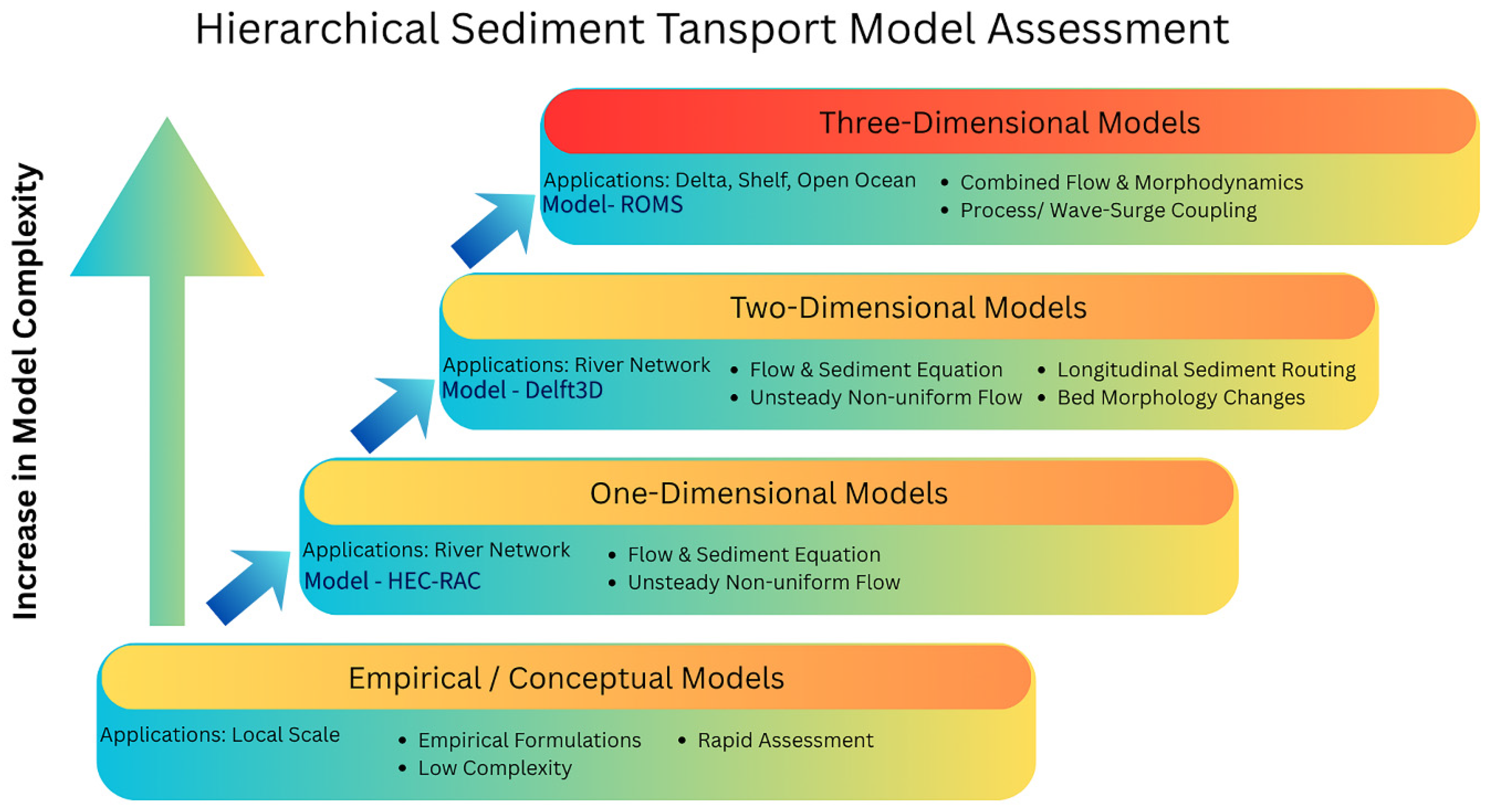
Therefore, regional sediment transport assessment under changing climate is best supported through model hierarchies and coupled workflows (
Figure 7), where process-based models provide physical realism and AI/ML or reduced-complexity approaches enhance computational efficiency and predictive capability in data-limited regions.
5.6. Benchmarking Uncertainty and Limitations
Benchmarking results should be interpreted cautiously because sediment transport model performance is strongly influenced by application context, numerical configuration, data availability, and expert interpretation. To improve robustness and reproducibility, the following limitations and potential mitigation strategies are identified:
Model performance may vary substantially across fluvial, estuarine, coastal, glacial, and marine environments because governing sediment processes, spatial scales, and hydrodynamic controls differ between systems. This limitation can be addressed through environment-specific benchmarking, application-oriented weighting schemes, and multi-scenario comparative testing rather than relying on universal rankings.
- 2.
Configuration sensitivity:
Model outcomes are highly sensitive to grid resolution, boundary conditions, parameterisation choices, turbulence closure schemes, sediment formulations, and calibration strategies. Future benchmarking studies should therefore incorporate sensitivity analysis, ensemble simulations, standardised calibration protocols, and uncertainty quantification methods to evaluate configuration-related variability.
- 3.
Data limitations:
Long-term observational datasets for morphodynamic evolution, sediment fluxes, and climate-scale forcing remain limited in many regions, restricting comprehensive model validation. Integration of remote sensing, data assimilation, continuous monitoring networks, and AI/ML-assisted sediment estimation may help improve validation coverage and long-term benchmarking reliability.
- 4.
Subjectivity in scoring:
Although the framework adopts evidence-based criteria, some degree of expert judgement is unavoidable, particularly for operational applicability and climate-readiness assessment. This issue may be reduced through multi-expert evaluation, stakeholder-driven weighting systems, probabilistic scoring approaches, and stochastic techniques such as Monte Carlo simulation to quantify scoring variability and confidence ranges.
Accordingly, the proposed framework should be interpreted as a flexible semi-quantitative decision-support benchmarking system rather than a deterministic ranking methodology.
6. Bibliometric Synthesis, Research Trends, and Knowledge Gaps
The benchmarking framework presented in the preceding section identifies the technical capabilities that appear most important for advancing climate-responsive sediment transport modelling. Although these findings are derived from systematic comparative evaluation of widely used numerical models, an important question remains: do these priorities reflect the broader evolution of sediment transport research, or are they specific to the benchmarked modelling frameworks?
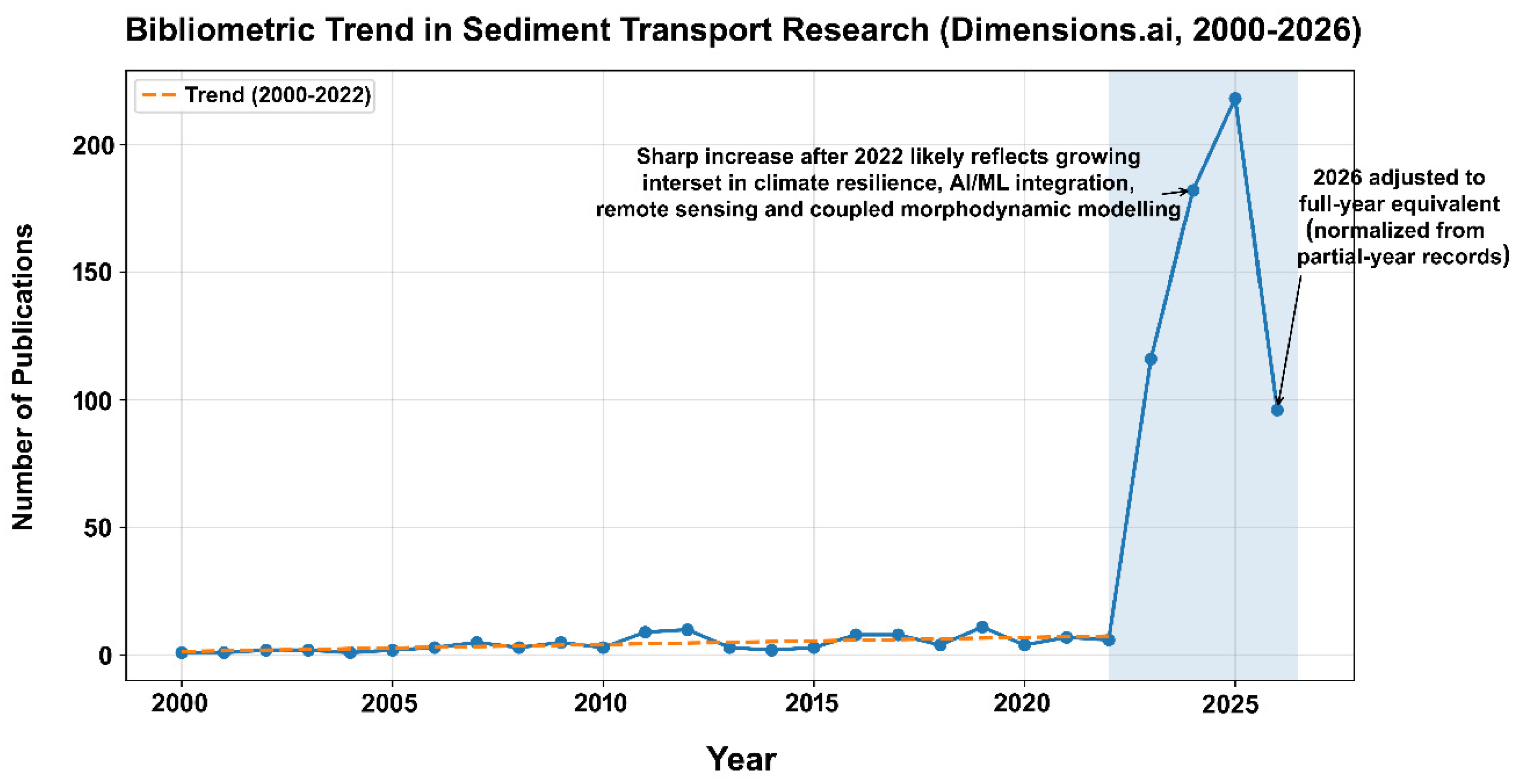
Bibliometric analysis provides an independent means of addressing this question by examining how the global scientific community has responded to emerging environmental challenges, technological innovation, and evolving modelling requirements. Unlike conventional literature reviews, bibliometric methods identify long-term patterns of scientific development through quantitative analysis of publication activity, thematic evolution, citation networks, and research collaboration. Consequently, bibliometric evidence complements technical benchmarking by revealing whether methodological advances identified through comparative model evaluation are also reflected in the wider trajectory of sediment transport research.
Within this review, bibliometric synthesis serves not as a descriptive overview of publication statistics but as an independent validation of the scientific insights derived from the benchmarking analysis. Convergence between these two lines of evidence would strengthen confidence in the proposed research priorities, whereas important discrepancies would highlight areas requiring further methodological development. The following analyses therefore evaluate how sediment transport research has evolved over the past two decades and whether emerging scientific themes align with the capabilities identified as most important for future climate-responsive regional sediment assessment. In the context of climate change, bibliometric synthesis is particularly useful for identifying emerging methodological directions (e.g., AI/ML and remote sensing integration), assessing the balance between fluvial and coastal research, and highlighting opportunities for cross-environment coupling required for regional sediment transport assessment.
This section presents a reproducible bibliometric synthesis based on the compiled Dimensions.ai database (2000–2026) and uses these results to frame research gaps and future priorities.
6.1. Publication Growth and Temporal Evolution (2000–2026)
The publication trend (shown in the orange line in
Figure 8) indicates an overall increase in sediment transport research since 2000, with a marked acceleration in recent years. This growth reflects increasing scientific and societal demand for improved prediction of sediment-driven hazards, such as floodplain deposition, reservoir sedimentation, delta retreat, coastal erosion, and offshore sediment mobility. The sharp rise after the early 2020s is also consistent with the rapid expansion of climate-risk research and the growing accessibility of satellite observations and open computational workflows.
The acceleration of publication activity after 2020 coincides with increasing international emphasis on climate resilience, integrated watershed management, high-resolution Earth observation, and computational advances in hydro-morphodynamic modelling. This temporal transition suggests that sediment transport research is increasingly responding to broader environmental and technological drivers rather than remaining focused on traditional hydraulic engineering applications.
6.2. Emerging Themes: Integration of Modelling, Remote Sensing, and AI/ML
A clear trend in the recent literature is the increasing convergence of three methodological pillars.
6.2.1. Process-Based Modelling Remains the Backbone
Hydrodynamic and morphodynamic numerical models continue to form the foundation of sediment transport research because they provide physically interpretable representations of sediment flux, bed evolution, erosion–deposition dynamics, and system response under varying hydrodynamic conditions. Their continued dominance does not necessarily indicate increased awareness of modelling approaches after 2023; rather, it reflects the expanding need to apply established process-based frameworks to emerging climate-related and large-scale environmental problems.
Recent growth in sediment modelling applications is primarily associated with increasing demand for climate resilience assessment, coastal hazard prediction, flood-risk analysis, river-basin management, and nature-based adaptation planning. Consequently, process-based models are now being applied more frequently in long-term scenario analysis involving sea-level rise, changing hydrological extremes, altered sediment supply, and coupled basin-to-coast morphodynamic evolution, extending beyond their traditional event-scale engineering applications.
6.2.2. Remote Sensing Enables Scaling and Monitoring
The increasing use of satellite and UAV-based observations reflects not only growing recognition of the value of remote sensing in sediment studies, but also major improvements in data accessibility, sensor resolution, cloud-computing platforms, and processing software. The wider availability of open-access satellite products (e.g., Sentinel and Landsat), lower-cost UAV systems, and user-friendly geospatial and AI-assisted processing tools has significantly reduced technical and operational barriers for large-scale sediment monitoring.
As a result, remote sensing is increasingly being integrated into sediment transport research for suspended sediment concentration (SSC) estimation, plume tracking, shoreline and bathymetric change detection, flood mapping, and validation of hydrodynamic and morphodynamic model predictions. These capabilities are particularly valuable in river plumes, deltas, estuaries, and coastal environments where field observations remain spatially sparse or logistically challenging.
6.2.3. AI/ML Is Accelerating Sediment Research
The rapid growth of AI/ML applications in sediment transport research is driven not only by methodological advances in data science, but also by increasing accessibility of computational resources, cloud-based platforms, GPU acceleration, and scalable high-performance computing (HPC) infrastructure. The availability of rentable cloud computing environments, parallel processing frameworks, and open-source AI libraries has substantially reduced the computational barriers previously associated with large-scale sediment simulations and data-intensive analysis.
Consequently, machine learning is increasingly being adopted for: (a) suspended sediment concentration (SSC) prediction and sediment-load forecasting; (b) automated extraction of sediment-related signals from satellite and UAV imagery; (c) parameter estimation, calibration support, and uncertainty reduction; and (d) surrogate and hybrid modelling approaches designed to reduce the computational cost of high-resolution numerical simulations.
Rather than replacing physically based models, AI/ML methods are increasingly functioning as complementary tools that enhance prediction efficiency, automate feature extraction, improve data assimilation, and support rapid scenario evaluation in complex sediment systems.
This shift is especially relevant for climate-driven regional assessment, where ensemble modelling and multi-decadal simulation requirements demand scalable approaches.
6.3. Linking Bibliometric Trends to Climate-Change Drivers
The bibliometric growth is strongly aligned with intensifying climate and environmental stressors that increasingly reshape sediment generation, transport pathways, and depositional dynamics across connected source-to-sink systems. Key drivers include: (a) increasing precipitation extremes and flood frequency, generating episodic sediment pulses and enhanced catchment erosion; (b) sea-level rise and storm-surge intensification, altering coastal sediment transport, shoreline stability, and delta evolution; (c) cryosphere melt and permafrost thaw, introducing new sediment sources and modifying seasonal sediment delivery regimes; (d) natural disasters such as wildfires, landslides, debris flows, and extreme storm events, which can rapidly destabilise landscapes and substantially increase post-disturbance sediment yield; and (e) human interventions including dams, river regulation, dredging, land-use change, and mining, which disrupt sediment connectivity and downstream sediment supply.
Collectively, these drivers reinforce the need for non-stationary sediment transport modelling frameworks capable of representing compound climate hazards, episodic disturbances, and coupled human–environment interactions. This also explains the increasing research focus on integrated modelling approaches combining hydrodynamics, morphodynamics, climate forcing, remote sensing, and data-driven methods. These drivers highlight the need for non-stationary sediment transport modelling and support the increasing focus on coupled approaches integrating climate forcing and human impacts.
6.4. Key Knowledge Gaps Limiting Regional Sediment Transport Assessment
From the previous comparative assessment, it is observed that despite significant progress, several persistent gaps limit the ability to conduct robust regional sediment transport assessment under the changing climate.
6.4.1. Weak Cross-Environment Coupling (Source-to-Sink Disconnect)
A major limitation remains the fragmentation of modelling efforts across environments. Many studies focus on rivers, estuaries, or coasts in isolation, whereas climate-driven sediment redistribution requires integrated modelling from catchment to shelf and deep-sea sinks. Without source-to-sink coupling, sediment deficit risks in deltas and coastal zones may be underestimated. At the same time, a substantial proportion of sediment transport modelling is intentionally designed for limited operational or site-specific objectives—such as channel stability, reservoir sedimentation, dredging assessment, shoreline evolution, or localised erosion control—without attempting to represent the complete sediment cascade. While such reduced-scope models are often computationally efficient and appropriate for engineering-scale applications, they may overlook upstream–downstream feedbacks, sediment connectivity, and cumulative climate-driven impacts that emerge across larger spatial and temporal scales. This disconnect between localised process modelling and holistic source-to-sink system behaviour highlights an important research gap in developing scalable frameworks that can balance domain-specific accuracy with broader Earth-system sediment dynamics.
6.4.2. Cohesive Sediment and Fine-Sediment Processes Remain Underrepresented
Cohesive sediment dynamics (e.g., flocculation, consolidation, and salinity-driven behaviour) remain difficult to model and are often simplified. This is critical because fine sediment dominates turbidity maxima, estuarine trapping, delta deposition, and pollutant transport—processes that are highly sensitive to climate forcing. To address this limitation, future modelling frameworks should incorporate process-based representations of cohesive sediment behaviour coupled with turbulence, salinity, and biogeochemical interactions, rather than relying solely on empirical parameterizations. Greater integration of laboratory experiments, field observations, and high-resolution monitoring data is also needed to improve parameter calibration and transferability across environments. In addition, hybrid modelling approaches that combine physics-based formulations with data-driven or machine-learning-assisted parameter estimation may help capture complex fine-sediment dynamics under changing climatic conditions while maintaining computational efficiency.
6.4.3. Limited Long-Term Morphodynamic Validation Datasets
Many models demonstrate good performance at short timescales, but long-term validation (multi-year to decadal) remains limited due to scarce repeated bathymetry, topography, and sediment flux observations. This reduces confidence in future climate scenario projections. Addressing this challenge requires sustained investment in long-term monitoring programmes that integrate remote sensing, repeated hydrographic surveys, autonomous sensing platforms, and in situ sediment measurements across riverine, estuarine, and coastal systems. Future studies should also prioritise the development of open-access benchmark datasets and standardised validation protocols to enable intercomparison among models and study regions. Assimilation of historical observations, paleoenvironmental reconstructions, and satellite-derived morphodynamic indicators can further strengthen long-term calibration and validation, thereby improving confidence in climate-scale sediment transport projections.
6.4.4. Uncertainty Quantification Is Still Not Standard Practice
Few sediment transport studies routinely apply ensemble simulations, probabilistic uncertainty estimates, or sensitivity-analysis frameworks. Climate-driven assessments require uncertainty-aware workflows because forcing, boundary-condition, and parameter uncertainties propagate strongly into sediment flux predictions. However, simply acknowledging uncertainty is insufficient; future modelling efforts should move toward standardised uncertainty quantification protocols embedded within sediment transport workflows. This includes the routine use of multi-model ensembles, scenario-based climate forcing, Bayesian or Monte Carlo uncertainty propagation, and global sensitivity analysis to identify dominant controlling parameters. In parallel, studies should report confidence intervals and predictive uncertainty alongside deterministic sediment estimates, particularly for engineering and coastal-risk applications. Establishing such practices would improve model transparency, reproducibility, and decision reliability, while enabling more robust comparison across studies and environmental settings.
6.4.5. Computational Constraints for Regional-Scale Simulations
High-resolution 2D/3D modelling remains computationally expensive, limiting its application to regional or multi-decadal simulations. This reinforces the need for model hierarchies, reduced-complexity approaches, and AI/ML surrogates to enable scalable regional assessment.
6.5. Synthesis: Implications for Model Selection and Benchmarking
The bibliometric trends support the benchmarking conclusion that climate-driven sediment assessment requires flexible modelling systems capable of integrating time-varying forcing, multi-sediment classes, and morphodynamic feedback. Models with strong coupling potential and broad applicability are increasingly preferred for climate scenario studies, while event-scale and environment-specific models remain essential for targeted hazard assessment.
The combination of bibliometric synthesis and benchmarking highlights that future progress depends on: (a) improved cross-environment coupling; (b) stronger cohesive sediment physics; (c) satellite-supported validation strategies; (d) hybrid physics–AI frameworks; (e) scalable computational workflows.
6.6. Transition to the Roadmap
Overall, the bibliometric synthesis reveals rapid expansion in sediment transport research, particularly in climate-relevant coastal and data-driven themes. However, the persistence of major gaps, especially source-to-sink coupling, cohesive sediment representation, and uncertainty-aware climate workflows, indicates that next-generation sediment transport assessment must integrate numerical modelling, remote sensing, and AI/ML within a unified, reproducible framework. The following section presents a strategic roadmap for achieving climate-responsive regional sediment transport assessment.
7. Roadmap Toward Climate-Responsive Regional Sediment Transport Assessment
The preceding benchmarking and bibliometric analyses consistently indicate that sediment transport research is undergoing a fundamental methodological transition. Traditional modelling approaches, which primarily focused on isolated hydraulic processes within relatively stationary environmental conditions, are progressively being replaced by integrated frameworks capable of representing coupled hydrological, geomorphological, climatic, and anthropogenic interactions across interconnected source-to-sink systems. This transition reflects the growing recognition that climate change is altering sediment dynamics in ways that cannot be adequately addressed through incremental improvements to conventional modelling strategies alone.
The convergence between comparative benchmarking and bibliometric evidence demonstrates that future progress will depend increasingly on interoperability among process-based numerical models, Earth observation systems, artificial intelligence, uncertainty-aware simulation, and scalable computational infrastructures. Consequently, the future of sediment transport assessment should not be viewed as the development of a single superior modelling platform but rather as the establishment of integrated scientific ecosystems that combine complementary modelling philosophies according to specific environmental conditions, management objectives, and decision-support requirements.
The roadmap proposed below synthesises the principal scientific insights derived throughout this review and translates them into a structured framework for future research, technological development, and operational implementation. Each recommendation is directly supported by the comparative benchmarking framework and independently reinforced through bibliometric evidence, providing a transparent and evidence-based foundation for guiding the next generation of climate-responsive sediment transport assessment.
The accelerating impacts of climate change on sediment transport—through intensified hydrological extremes, sea-level rise, cryosphere melt, and altered storm climatology—demand next-generation assessment frameworks that are scalable, non-stationary, and source-to-sink integrated. While process-based numerical models remain the backbone of sediment transport prediction, their application to regional climate assessment is limited by data scarcity, computational constraints, and incomplete representation of key processes such as cohesive sediment dynamics and human-driven sediment fragmentation. At the same time, remote sensing and AI/ML methods are rapidly expanding, offering new opportunities for monitoring, parameter estimation, and computational acceleration.
Table 6 summarises priority research and implementation pathways required to advance toward climate-responsive regional sediment transport assessment. The roadmap is structured across progressive stages. At the beginning, the problem of data scarcity can be addressed by strengthening observational foundations through improved sediment monitoring networks, standardised datasets, and remote sensing-based retrieval of suspended sediment dynamics. The next stage emphasises development of integrated modelling frameworks, including process-based hydro-morphodynamic models, robust representation of cohesive and non-cohesive sediment processes, and uncertainty quantification under non-stationary climate forcing. The third important stage highlights the role of AI/ML-enabled hybrid approaches for scalable sediment prediction, surrogate modelling, parameter optimisation, and data assimilation. The roadmap culminates in operational and policy-relevant applications, including regional sediment budget assessment, identification of sediment deficit hotspots, enhanced hazard forecasting (flood-driven sediment pulses, delta instability, coastal erosion), and decision support for climate adaptation planning. Collectively, this roadmap provides a structured vision for bridging data gaps and modelling limitations while enabling reproducible, transferable, and scenario-based sediment transport assessments under future climate change. The following sections elaborate on the proposed stages of the future roadmap.
7.1. Near-Term Priorities (1–3 Years): Strengthening Data Foundations and Reproducibility
The near-term priorities focus on actions that are immediately achievable using existing technologies, monitoring infrastructure, and modelling capabilities. The proposed 1–3 year timeframe reflects developments that can realistically be implemented by research groups, agencies, and regional monitoring programmes without requiring major computational or institutional restructuring. These priorities primarily address critical data gaps, reproducibility, and validation deficiencies currently limiting climate-scale sediment transport assessment.
In the near term, priority should be given to improving the physical realism, reproducibility, and transparency of sediment transport modelling. Particular emphasis is needed on strengthening the representation of cohesive sediment dynamics, vegetation–sediment interactions, bank erosion processes, glacier-derived sediment inputs, and multi-scale sediment connectivity. Equally important is the development of standardised benchmarking datasets, transparent validation protocols, and open computational workflows that improve comparability among modelling frameworks and enhance confidence in predictive applications.
Parallel advances in Earth observation should focus on integrating high-resolution satellite imagery, LiDAR, UAV observations, and continuous environmental monitoring into routine model calibration and validation. These developments will improve spatial representation of sediment dynamics while reducing uncertainty associated with data scarcity in many regions of the world.
7.1.1. Establish Open, Standardised Sediment Observation Datasets
A critical near-term need is the development of open sediment databases. The database integrates in situ sediment concentration and grain-size observations; river discharge and water level records; repeated bathymetry/topography (LiDAR/UAV/SfM); sediment deposition/erosion surveys; coastal shoreline change and plume datasets.
UAV-SfM surveys combined with acoustic Doppler current profiler (ADCP) measurements can provide seasonal morphodynamic datasets for rapidly evolving deltas and braided rivers. Similarly, integrating Sentinel-2 turbidity retrievals with in situ suspended sediment concentration measurements can support calibration of estuarine sediment transport models. Such datasets should be quality-controlled, accompanied by uncertainty metadata, and designed to support calibration and validation of both physics-based and AI-driven models.
7.1.2. Improve Reproducibility in Sediment Modelling Workflows
To support robust regional assessment, modelling studies must increasingly provide transparent boundary conditions and parameter sets; clear documentation of sediment formulations used; reproducible preprocessing and postprocessing pipelines; and standardised reporting of calibration and performance metrics. Publishing Delft3D, TELEMAC, or HEC-RAS model configurations through open repositories (e.g., GitHub or HydroShare) alongside forcing datasets and calibration scripts would allow independent benchmarking and inter-comparison across climatic regions. Reproducibility is essential for reducing uncertainty in model transferability and improving confidence in regional climate impact assessments.
7.1.3. Expand Remote Sensing Integration for Monitoring and Validation
Remote sensing should be adopted systematically for: SSC/turbidity mapping (optical sensors); flood extent and wetland inundation (SAR); morphologic change detection (LiDAR/UAV); and coastal plume tracking and shoreline change. Sentinel-1 SAR imagery can support floodplain inundation mapping during monsoon or cyclone events, while ICESat-2 and airborne LiDAR datasets can quantify coastal elevation changes and erosion hotspots. Near-term progress will come from combining remote sensing with targeted field campaigns to improve retrieval calibration and strengthen numerical model validation.
7.2. Medium-Term Priorities (3–7 Years): Hybrid Modelling, Coupling, and Uncertainty-Aware Projections
The medium-term priorities represent developments that require methodological advancement, multi-institutional collaboration, and increased computational integration beyond current standard practice. The 3–7-year timeframe reflects the expected period needed to mature hybrid modelling architectures, uncertainty-aware workflows, and coupled regional systems into operational research tools applicable across multiple environments.
Over the medium term, sediment transport modelling should evolve toward interoperable computational frameworks that combine process-based simulation with remote sensing, artificial intelligence, data assimilation, uncertainty quantification, and high-performance computing. Hybrid modelling strategies capable of integrating physical process representation with adaptive machine learning algorithms are expected to improve parameter estimation, computational efficiency, scenario analysis, and predictive scalability while maintaining scientific interpretability.
Research should also prioritise uncertainty-aware modelling through ensemble simulation, probabilistic forecasting, and sensitivity analysis. As climate projections become increasingly important for infrastructure planning and environmental management, transparent communication of modelling uncertainty will become as important as improving deterministic prediction accuracy.
7.2.1. Develop Hybrid Physics–AI Sediment Transport Frameworks
Hybrid approaches offer a pathway to maintain physical interpretability while improving prediction and scalability. Priority directions include: (a) ML-assisted estimation of sediment parameters (critical shear stress, roughness, settling velocity); (b) AI-based surrogate models for computational acceleration; (c) bias correction models applied to process-based outputs; (d) physics-informed neural networks to embed conservation constraints. Machine-learning surrogates trained on high-resolution Delft3D simulations could rapidly emulate storm-driven sediment redistribution under multiple climate scenarios, significantly reducing computational demand. Similarly, physics-informed neural networks may improve sediment flux estimation while preserving mass conservation constraints.
7.2.2. Advance Cohesive Sediment and Fine-Sediment Process Representation
Cohesive sediment dynamics remain a persistent weakness in many modelling systems. Medium-term development should prioritise: (a) flocculation and aggregation modelling; (b) consolidation and bed strength evolution; (c) salinity and stratification effects in estuaries; and (d) sediment–biogeochemistry coupling where relevant. Estuarine turbidity maxima in systems such as the Yangtze or Mississippi estuaries are strongly influenced by salinity-induced flocculation and stratification processes that are often simplified in conventional models. Improved cohesive sediment physics is therefore essential for accurately representing deltaic and estuarine climate responses.
7.2.3. Implement Source-to-Sink Coupling Frameworks
Regional sediment assessment requires connectivity across environments, linking: (a) hillslope erosion, river transport, and floodplain storage; (b) river delivery, and estuarine trapping/resuspension; (c) delta/coastal redistribution, shelf transport, and deep-sea deposition. Coupling SWAT-derived watershed sediment yield estimates with Delft3D or ROMS coastal simulations could allow assessment of how upstream land-use change and extreme rainfall alter downstream delta stability and offshore sediment dispersal. Such frameworks are crucial for evaluating sediment deficits, coastal vulnerability, and offshore sediment hazards under future climate forcing.
7.2.4. Standardise Uncertainty Quantification and Ensemble Modelling
Climate-driven sediment projections should routinely include: (a) forcing uncertainty (climate model ensembles, scenario ranges); (b) parameter uncertainty (sediment properties, roughness, erosion coefficients); (c) structural uncertainty (model choice, dimensionality, sediment formulations); and (d) probabilistic outputs (confidence intervals, exceedance probability metrics). Ensemble simulations forced by multiple CMIP6 climate models could quantify the range of future sediment delivery to vulnerable deltas under different warming scenarios. Embedding uncertainty quantification into standard practice will improve transparency and credibility for climate adaptation planning.
7.3. Long-Term Priorities (7–15+ Years): Earth-System Integration and Regional Sediment Forecasting
The long-term priorities involve transformative developments requiring sustained international collaboration, large-scale computational infrastructure, and integration across Earth-system disciplines. The proposed 7–15+ year timeframe reflects the complexity of embedding sediment dynamics into operational climate and Earth-system frameworks. The “15+” notation is intentionally open-ended because some developments—particularly fully coupled Earth-system sediment forecasting—may extend beyond two decades depending on computational and observational progress.
Looking beyond the next decade, sediment transport assessment is likely to evolve toward fully integrated digital Earth-system frameworks in which numerical simulation, Earth observation, autonomous environmental monitoring, artificial intelligence, and cloud-based computational infrastructures operate within continuously updated digital twins of river basins, estuaries, and coastal environments. Such systems would enable near-real-time prediction of sediment dynamics, adaptive management under changing climatic conditions, and evidence-based evaluation of alternative environmental and engineering interventions.
Achieving this vision will require interdisciplinary collaboration among geomorphologists, hydrologists, hydraulic engineers, remote sensing specialists, climate scientists, computer scientists, and environmental decision-makers. Equally important will be sustained investment in open environmental data infrastructures, reproducible computational workflows, long-term monitoring networks, and internationally coordinated benchmarking initiatives that facilitate scientific transparency and accelerate methodological innovation.
7.3.1. Embed Sediment Transport in Climate and Earth-System Modelling Frameworks
Long-term progress requires integrating sediment modules into: (a) regional climate models (RCMs) for storm/flood sediment extremes; (b) Earth-system models (ESMs) to represent sediment–carbon coupling; and (c) coupled river–ocean modelling systems for regional sediment delivery pathways. Integrating sediment modules within coupled river–ocean climate systems could allow simulation of sediment redistribution under compound drivers such as sea-level rise, glacier retreat, and changing monsoon intensity. This integration is essential for assessing long-term coastal vulnerability and sediment-driven biogeochemical feedback.
7.3.2. Build Regional Sediment Hazard Forecasting Systems
Future climate-responsive sediment assessment should evolve into operational forecasting frameworks capable of: (a) early warning for sediment-driven flooding and channel instability; (b) forecasting delta retreat and coastal erosion hotspots; (b) predicting reservoir sedimentation risks under extreme rainfall regimes; (c) assessing offshore turbidity current hazards. Cloud-based forecasting systems assimilating near-real-time satellite data and hydrometeorological forecasts could provide early warning for sediment-laden flood hazards in rapidly urbanising river basins.
7.3.3. Support Decision-Making and Climate Adaptation Planning
Regional sediment assessment must ultimately translate into actionable indicators for policy and management, including: (a) sediment deficit indices for deltas and coasts; (b) erosion susceptibility under extreme rainfall intensification; (c) sedimentation risk for reservoirs and infrastructure; (d) nature-based solution feasibility (restoration, sediment nourishment). Sediment budget indicators could support prioritisation of coastal nourishment projects or wetland restoration strategies in sediment-starved delta systems. Decision-ready sediment modelling will require sustained collaboration among scientists, engineers, planners, and policymakers.
7.4. Recommended Framework for Future Regional Sediment Transport Assessment
The evidence synthesised throughout this review supports a conceptual transition from isolated numerical modelling toward integrated climate-responsive sediment assessment. In this framework, process-based numerical models remain the scientific core of sediment prediction, while Earth observation provides continuous environmental information, artificial intelligence enhances calibration and computational efficiency, uncertainty analysis quantifies predictive confidence, and digital computational infrastructures enable scalable implementation across diverse geomorphic environments. Rather than functioning as independent technologies, these components should be viewed as complementary elements of a unified modelling ecosystem.
This integrated perspective provides a practical foundation for future sediment transport research by linking scientific understanding with operational decision support. It also offers a transparent pathway for developing modelling systems capable of supporting climate adaptation, river basin management, coastal resilience, ecosystem conservation, and sustainable infrastructure planning under increasingly dynamic environmental conditions. Based on the synthesis of numerical modelling, benchmarking, and bibliometric trends, a climate-responsive source-to-sink regional sediment assessment framework should adopt:
1. Adaptive model hierarchy: Combine reduced-complexity tools, hybrid AI–physics approaches, and high-resolution 3D process-based models depending on the spatial scale, process complexity, and computational requirement. Reduced-complexity models are appropriate for basin-scale scenario screening, whereas fully coupled 3D models may be necessary for estuarine stratification, turbidity maxima, or storm-driven coastal sediment dynamics.
2. Data fusion: Integrate remote sensing, in situ monitoring, paleoenvironmental archives, and climate reanalysis datasets to improve calibration and validation coverage.
3. Hybrid acceleration: Apply AI/ML for parameter estimation, surrogate modelling, data assimilation, and bias correction while retaining physical consistency.
4. Connectivity focus: Implement source-to-sink coupling across hillslopes, rivers, estuaries, coasts, and offshore environments.
5. Uncertainty awareness: Apply ensemble modelling, probabilistic reporting, and sensitivity analysis as standard practice.
6. Reproducibility and benchmarking: Publish workflows, datasets, and benchmark cases through open-access platforms to improve transferability and intercomparison.
This integrated framework enables flexible selection of modelling complexity according to the research or management objective, while improving scalability, interpretability, and climate resilience assessment across regional sediment systems.
8. Conclusions
This review provides a comprehensive and climate-focused synthesis of sediment transport research aimed at advancing regional sediment transport assessment under rapidly changing environmental conditions. The evidence reviewed demonstrates that sediment transport systems are increasingly influenced by the combined effects of climate-driven non-stationarity and human-induced alterations to sediment connectivity. Changes in precipitation extremes, flood regimes, sea-level rise, storm intensity, glacier retreat, and permafrost degradation are reshaping sediment production, transport pathways, and depositional environments across river basins, estuaries, deltas, and coastal systems. Simultaneously, dam construction, river regulation, land-use change, sediment extraction, and coastal engineering continue to modify natural source-to-sink sediment dynamics, often resulting in sediment deficits, enhanced erosion, and increased environmental vulnerability.
A key contribution of this review is the integration of process-based understanding, bibliometric synthesis, and model benchmarking within a unified climate-responsive assessment framework. The bibliometric analysis highlights sustained growth in sediment transport research between 2000 and 2026, with particularly strong expansion in studies involving remote sensing, Earth observation, artificial intelligence, and machine learning. These developments reflect a broader transition toward data-rich and computationally advanced approaches capable of addressing the increasing complexity of sediment systems under changing climate conditions.
The comparative benchmarking assessment further demonstrates that current modelling frameworks are not universally implementable across all sediment transport applications. Integrated hydro-morphodynamic models such as Delft3D, SCHISM, TELEMAC, and ROMS exhibit strong capability for climate-sensitive and multi-environment assessments, whereas specialised tools including HEC-RAS, SRH-2D, and XBeach remain indispensable for targeted riverine, floodplain, and coastal applications. The benchmarking results emphasise that model selection should be guided by study objectives, dominant sediment processes, spatial and temporal scales, data availability, and computational requirements rather than by model complexity alone.
The review also highlights the growing importance of integrating remote sensing and artificial intelligence with conventional numerical modelling. Remote sensing provides critical observations for monitoring sediment dynamics, validating model outputs, and extending assessment capabilities to data-scarce regions. Artificial intelligence and machine-learning approaches offer significant potential for parameter estimation, surrogate modelling, uncertainty reduction, and rapid prediction of sediment behaviour, particularly where observational data and computational resources are limited. Rather than replacing process-based models, these technologies are increasingly emerging as complementary tools that enhance model performance and support more adaptive assessment frameworks.
Despite substantial progress, several challenges continue to constrain robust regional sediment transport assessment. These include limited representation of cohesive and fine-sediment processes, insufficient coupling across catchment-to-coast systems, scarcity of long-term morphodynamic observations, and the relatively limited adoption of uncertainty-aware modelling approaches. Addressing these gaps will require coordinated efforts to improve open-access sediment datasets, establish reproducible modelling workflows, strengthen model–data integration, and promote transparent uncertainty quantification.
Looking forward, achieving climate-responsive sediment transport assessment will require a staged and integrated research pathway. Near-term priorities should focus on expanding sediment monitoring networks, improving data accessibility, and promoting reproducible analytical workflows. Medium-term advances should emphasise hybrid physics-based and AI-enhanced modelling systems, improved Earth-observation integration, and standardised climate-scenario assessment frameworks. In the longer term, sediment dynamics should be more fully incorporated into coupled Earth-system models, digital-twin environments, and operational forecasting systems capable of supporting real-time environmental decision-making.
Ultimately, sustainable management of river basins, deltas, estuaries, reservoirs, and coastal environments under accelerating climate change depends on the ability to accurately quantify sediment redistribution and anticipate future sediment-related risks. The climate-responsive framework presented in this review provides a foundation for next-generation regional sediment transport assessment by integrating process-based modelling, Earth observation, artificial intelligence, and evidence-based benchmarking within a unified source-to-sink perspective. Such integration is essential for supporting climate adaptation, reducing sediment-related hazards, and enhancing the long-term resilience of natural and engineered environments in the Anthropocene.





 ,
,