1. Introduction
1.1. Urban Sustainability and the Collaboration Problem
Urban areas and territories today face unprecedented challenges in realising sustainability goals. These challenges are inherently complex and interlinked, encompassing environmental, social and economic dimensions, as well as enabling resilience in communities [
1]. Despite the growing awareness of the need for sustainability and the increasing engagement of different stakeholders, effective cross-sector collaboration can still be improved [
2].
Cities typically organise their operations into specialised departments, each focusing on specific aspects of urban management such as transport, housing, energy or social services. While this specialisation allows for deep expertise in each area, it often leads to isolated approaches to sustainability challenges that require integrated solutions. Recent studies show that even when cities establish sustainability offices or programmes, these initiatives are often unable to achieve meaningful cross-departmental coordination [
3]. Furthermore, urban sustainability involves not only city governments but also private sector businesses, community organisations, academic institutions and citizens. Each group brings valuable perspectives and resources but often works with different priorities, timeframes and measures of success. Current mechanisms for collaboration, such as public consultations or regular stakeholder meetings, are often insufficient to create lasting partnerships or develop integrated solutions.
Several key barriers hinder effective communication and collaboration between urban sustainability stakeholders. Firstly, different sectors often use different technical vocabularies and frameworks, making it difficult to reach a common understanding. For example, urban planners, environmental scientists, and community organisations may use different terminology to describe similar concepts or priorities [
4]. Secondly, stakeholders often work with different temporal perspectives. While municipal planning often spans decades, private sector initiatives may focus on short-term outcomes, and community groups may seek immediate improvements to local conditions. These unaligned timeframes can make it difficult to develop coordinated sustainability strategies. Last but not least, power and resource imbalances among stakeholders can hinder true collaboration. Smaller community organisations or citizen groups may not have the technical expertise or resources to effectively engage in sustainability planning processes, while larger institutions may dominate discussions and decision-making.
The consequences of fragmented approaches to urban sustainability are significant and compounding. When different sectors pursue sustainability initiatives independently, they may miss opportunities for synergies or, worse, implement solutions that interfere with each other. Transport infrastructure projects may not be aligned with housing plans, leading to increased car dependency and higher emissions. Fragmentation also leads to inefficient allocation of resources: multiple stakeholders may invest in similar or overlapping initiatives without coordination, while other important areas remain underfunded.
1.2. Existing Approaches: Participatory Tools, Serious Games, and the Climate Fresk Legacy
To address these challenges, there is a clear need for frameworks and tools that can facilitate meaningful collaboration between sectors and operationalise interventions [
5]. Such frameworks need to fulfil several functions: they should provide a common language for discussing sustainability challenges, enable stakeholders to visualise the connections among different urban systems, and facilitate the development of integrated solutions. They should also remain accessible to stakeholders with different levels of technical expertise while being rigorous enough to enable meaningful action.
Serious games have emerged as powerful tools in urban planning, offering innovative approaches to stakeholder engagement and complex problem-solving [
6]. They are interactive experiences designed primarily for educational, training, or therapeutic purposes rather than pure entertainment, while still employing game mechanics to engage users. These games are used across sectors including healthcare, education, corporate training, and the military to simulate real-world scenarios, develop skills, or raise awareness about complex issues. A representative example from the health sector is GRAPHIC, where dental students work in a simulated town and design oral health promotion activities [
7]. In the urban planning field, examples include Metropolis, a city simulator for collective decision-making in which emergent behaviours from the simulation inform real-life planning decisions [
8]; the Mobility Game [
9]; and the Sustainability Futures Game [
10], all illustrating how serious games can function as effective participatory planning tools, including in online settings [
11,
12,
13,
14].
Research on serious game design has produced several frameworks for systematically linking gameplay to intended outcomes, including MDA [
15], the LM-GM mapping [
16], and the Serious Game Design Assessment Framework [
17]. These frameworks emphasise that effective serious games require explicit alignment between game mechanics and learning objectives, a principle that is well established in theory but inconsistently applied in the urban planning domain, where many games are designed around engagement and participation without formalising the connection to structured assessment frameworks.
Among recent participatory methodologies, the Climate Fresk has developed into a particularly influential educational tool that helps participants understand climate change through collaborative learning [
18]. The methodology centres on a map-based system in which participants work together to create a visual representation of the causes and effects of climate change. Its success lies in its ability to make complex scientific concepts accessible through guided discovery and collaborative learning. The Placemaking Maptivity presented in this paper draws methodological inspiration from the Climate Fresk while substantially restructuring the underlying content: rather than a linear cause-and-effect chain, urban sustainability is represented as a two-dimensional matrix capturing multiple interdependencies between areas of action and sustainability purposes.
While existing participatory planning tools have each made significant contributions, they face limitations across three dimensions that the Maptivity is designed to address. Simulation-based planning games, such as Metropolis and the Mobility Game, foreground emergent dynamics and scenario play but do not provide a mechanism for mapping proposed actions against an internationally validated sustainability assessment framework. The Climate Fresk excels at building systemic awareness of climate cause-and-effect chains but is not designed for multi-dimensional collaborative prioritisation at neighbourhood scale. Standard deliberative workshop formats support participant dialogue and co-production but lack the game structure that can scaffold engagement from participants with limited prior exposure to sustainability frameworks. The Placemaking Maptivity is designed to address all three limitations simultaneously: it couples the ISO 37101 [
19] cross-analysis matrix—an internationally recognised standard for sustainable community management—with a card-based game mechanic that supports collaborative mapping and prioritisation at neighbourhood scale, using a facilitation structure accessible to mixed-expertise groups [
20].
1.3. The ISO 37101 Framework and the Operationalisation Gap
International standards such as ISO 37101 provide a basis for structured sustainability frameworks at community level, but their abstract nature can make them difficult to apply in practice [
21]. What is needed is a bridge between these high-level frameworks and the practical realities of urban sustainability planning, a tool that can help different stakeholders develop a common understanding of the challenges and opportunities while fostering meaningful collaboration [
22].
ISO 37101:2016 is an international standard that establishes requirements for a management system for sustainable development in communities [
19]. Its primary purpose is to help communities improve their sustainability, resilience, and quality of life by addressing environmental, social, and economic challenges through a structured management system based on the Plan–Do–Check–Act (PDCA) cycle. It was created to give city leaders and stakeholders a common reference point and set of guidelines for planning, implementing, and assessing sustainability strategies.
At the core of the standard is a cross-analysis matrix that maps six purposes of sustainability (attractiveness, preservation of environment, resilience, responsible resource use, social cohesion, and well-being) against twelve areas of action (such as governance, education, mobility, and biodiversity). This matrix structure helps cities evaluate how their strategies, programmes, and projects contribute to different aspects of sustainability, enabling a holistic approach that ensures balanced development across environmental, social, and economic dimensions. ISO 37104:2019 [
23] provides practical guidance for applying this cross-analysis methodology at city level, while ISO 37120:2018 [
24] defines quantitative indicators mapped to the six purposes, enabling performance monitoring [
25].
Despite the strengths of existing serious games in supporting experiential learning, few incorporate internationally recognised sustainability standards such as ISO 37101 as a core structural element, and fewer still provide a systematic method for mapping multi-dimensional urban systems onto a shared analytical scaffold.
1.4. Research Gap, Contribution, and Research Question
Existing participatory approaches and serious gaming methods do not consistently integrate structured sustainability frameworks with systems-based visualisation in a way that supports coordinated, actionable urban planning across diverse stakeholders. This paper addresses that gap by presenting the Placemaking Maptivity, a card-based serious game that operationalises the ISO 37101 cross-analysis matrix as a shared analytical scaffold for participatory sustainability planning at the neighbourhood scale.
The contribution is twofold: (i) a designed artefact, the Maptivity itself, including its card system, board, and facilitation protocol, and (ii) prescriptive knowledge about how an internationally recognised management-system standard can be made operationally accessible to mixed-expertise audiences through serious-game mechanics, with each design choice traceable through the LM-GM framework to a defined learning objective. This paper presents a formative artefact-development study in the Design Science Research sense: the contribution is the artefact and the design knowledge generated through its iterative development, not a validated planning methodology. Broader claims about effectiveness, transferability, and operational impact are proposed as directions for future research rather than conclusions of the present study.
The guiding research question is as follows: How can a serious game translate the ISO 37101 framework into a collaborative planning experience that enables diverse stakeholders to identify multi-dimensional sustainability contributions, map interdependencies across urban systems, and prioritise coordinated action at the neighbourhood scale?
The remainder of the paper is organised as follows.
Section 2 presents the Design Science Research approach, the artefact, the workshop structure and learning design, and the beta-testing protocol.
Section 3 reports the results of four iterative beta-testing rounds and the stakeholder feedback gathered.
Section 4 discusses implications, limitations, and future evaluation directions.
Section 5 concludes.
2. Materials and Methods
2.1. Design Science Research Approach
The development of the Placemaking Maptivity follows a Design Science Research (DSR) approach [
26,
27], which is well-suited to research that produces and evaluates purposeful artefacts addressing real-world problems. DSR proceeds through iterative cycles of design, demonstration, and evaluation, generating both a practical artefact and prescriptive knowledge about how and why it works. The Placemaking Maptivity is the design artefact; the sustainability planning workshops in which it is deployed serve as the demonstration and evaluation contexts.
Table 1 maps the phases of the DSR process model [
27] to the structure of this paper. The problem identification and motivation are presented in
Section 1, where we characterise the fragmentation of cross-sector sustainability collaboration and the gap between abstract ISO frameworks and participatory practice.
Section 2 defines the objectives of a solution, describes how the Climate Fresk methodology, serious game principles, and the ISO 37101 framework were synthesised into a design concept, and details the artefact and workshop protocol.
Section 3 reports on iterative demonstration and evaluation through four rounds of beta testing with diverse stakeholder groups.
The Maptivity is designed as a facilitated process rather than a standalone toolkit. Its effectiveness relies on the interaction between structured materials, facilitation expertise, and contextual adaptation to specific urban settings. Therefore, while this paper presents the methodological framework and the artefact it produced, the full implementation process involves additional layers of guidance and practice-based knowledge that are themselves iteratively refined through use.
2.2. Adaptation from the Climate Fresk Methodology
In adapting the Climate Fresk methodology for urban sustainability, we retained the core principle of collaborative learning but redesigned the content structure. In contrast to climate change, which follows relatively linear cause-and-effect chains, urban sustainability represents a more interconnected web of relationships. The adaptation process focused on capturing these multiple interdependencies while maintaining the engaging, discovery-based nature of the original format.
The key innovation in this adaptation was the development of a matrix-based approach rather than a linear chain. Where the Climate Fresk arranges cards along causal sequences, the Placemaking Maptivity places them at the intersections of a two-dimensional framework, allowing participants to explore how urban elements contribute to multiple sustainability goals simultaneously and better reflecting the reality of urban systems. The customisation process involved several rounds of testing with different stakeholder groups (city officials, private sector, community organisations, academic institutions, and citizens) to ensure that the tool remains accessible while reflecting the complexity of urban sustainability.
2.3. The Placemaking Maptivity Artefact
2.3.1. The Placemaking Map
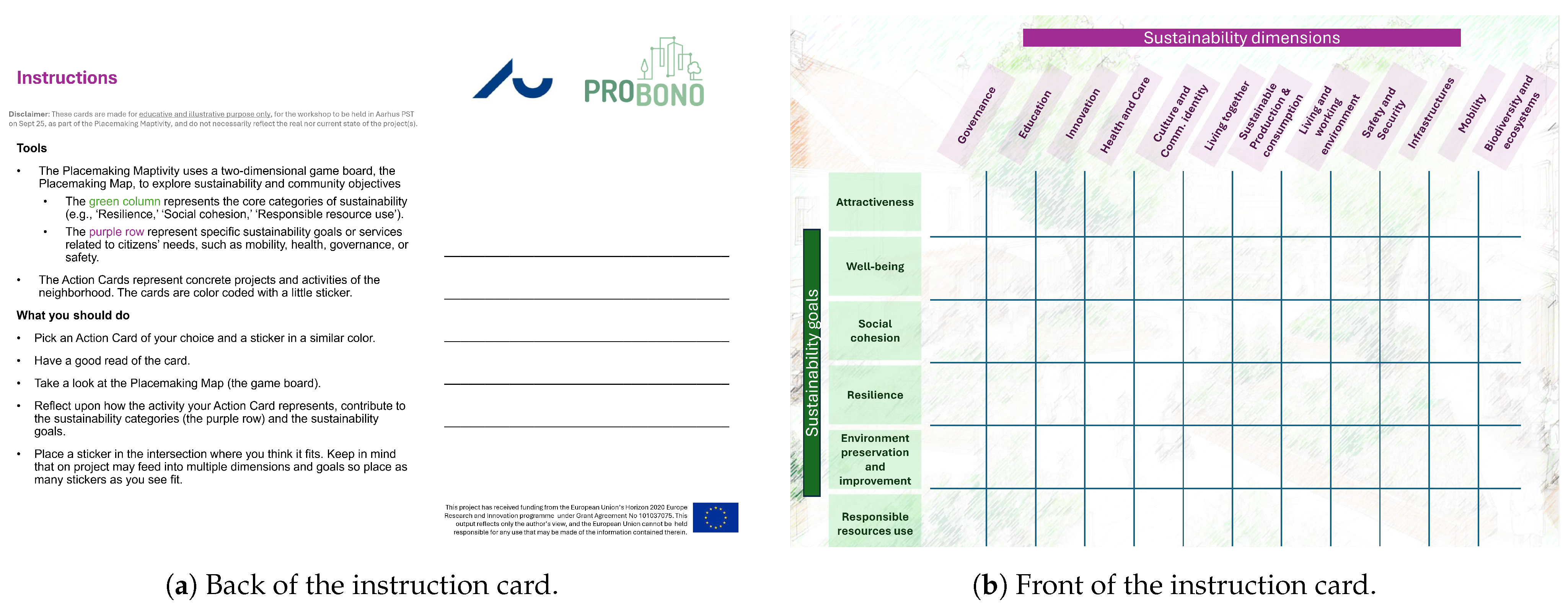
The Placemaking Map is a large-format board displaying the ISO 37101 cross-analysis matrix, with the twelve areas of action as columns and the six sustainability purposes as rows. Each cell represents a specific intersection, for example, “Mobility × Resilience” or “Governance × Social Cohesion”, and provides a structured space for card placement. To make the framework more intuitive without changing its essential structure, the matrix labelling was simplified to plain language, but the underlying six-by-twelve coverage of the ISO standard was preserved.
2.3.2. The Card System
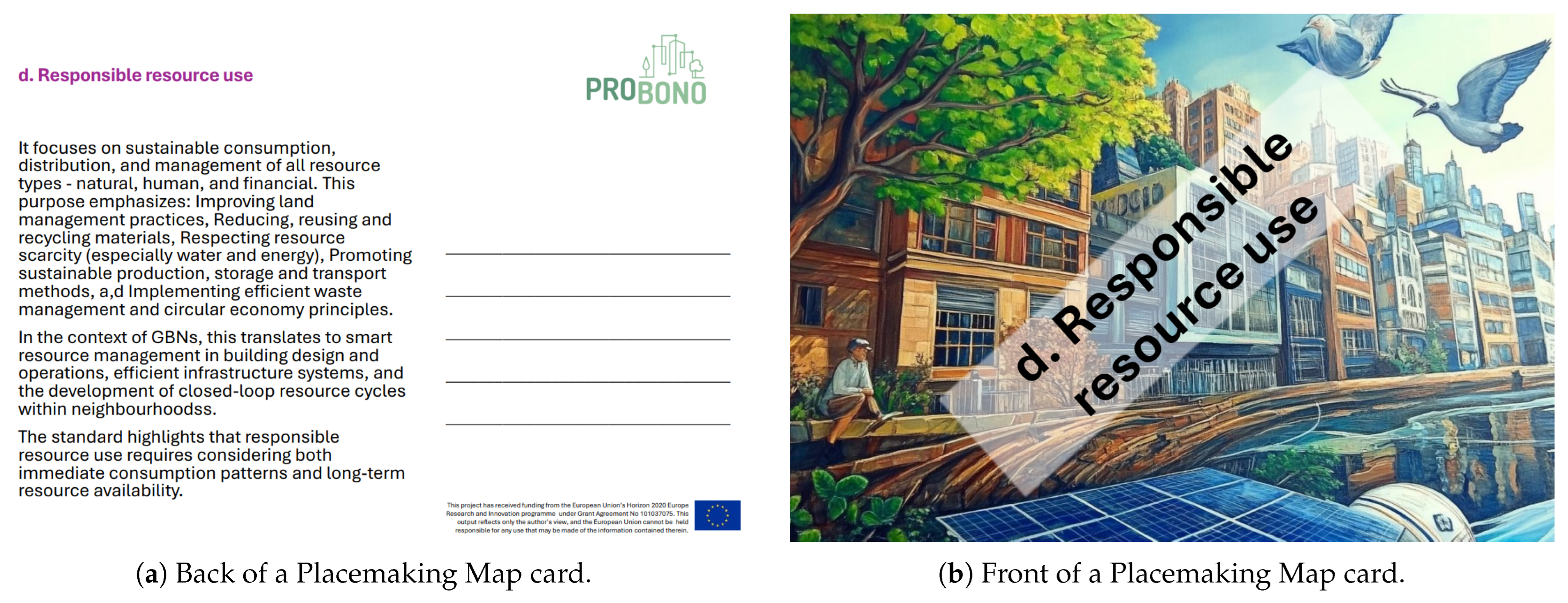
The card deck consists of three types of cards. Framework cards (18 cards: twelve areas of action plus six purposes, corresponding to the ISO 37101 framework) are used during the initial orientation phase to collaboratively assemble the board. Action cards represent concrete neighbourhood projects or activities, for example, an energy efficiency campaign, a community library, or a cycling infrastructure project. Each action card is postcard-sized, with an illustration on one side and a brief description on the other (see
Figure 1). The postcard format was chosen for its tactile quality and portability: cards are large enough to be read across a table, small enough to handle and rearrange freely, and serve as takeaways that participants can share with colleagues after the workshop. Guidance cards (see
Figure 2) provide step-by-step instructions for each workshop phase.
Action cards are colour-coded by area of action to help participants quickly identify thematic clusters. Crucially, the cards do not pre-assign a matrix position: participants must decide where each card belongs, discuss their reasoning with peers, and justify the placement. A single card may be placed at multiple intersections using small stickers, reflecting the multi-purpose nature of real-world sustainability projects. This mechanic operationalises learning objective (i) described in
Section 2.4.2 below.
The initial action card pool was drawn from the real-world project portfolios of the PROBONO Horizon 2020 consortium, which provided a set of documented neighbourhood-scale sustainability actions across participating European cities. The selection was opportunistic rather than systematic: cards were developed from cases that were already available, described, and relevant to the ISO 37101 areas of action, rather than assembled through a structured sampling of urban sustainability plans. This approach ensured that the cards reflected genuine planning activities and could be discussed by participants with direct knowledge of similar projects, while acknowledging that the resulting set does not constitute a representative cross-section of European urban sustainability practice. Coverage gaps identified during beta testing informed iterative additions to the card deck and are discussed in
Section 3.1.4.
The cards also serve as useful takeaways for participants, allowing them to revisit the concepts and discussions explored during the workshop. This reinforces learning and supports broader dissemination of the project’s principles and methodologies as participants can share the cards and insights with others in their organisations or communities.
2.3.3. Visual and Interactive Design
The visual design of the Placemaking Maptivity puts the focus on clarity and engagement. To make abstract sustainability concepts tangible and approachable, the Maptivity uses a collection of illustrated cards, each representing different urban projects, actions, or scenarios. Each card contains carefully selected images and concise text that convey key concepts without overwhelming participants. The interactive elements have been designed to encourage both individual reflection and group discussion. The physical act of placing and connecting cards creates a tangible representation of the relationships within urban sustainability. This design supports experiential learning by enabling participants to externalise and visualise complex system relationships and to collectively negotiate their meaning in a structured and accessible setting.
The design of the Placemaking Maptivity is guided by five basic principles:
Accessibilitythe tool must be understandable to participants regardless of their technical background, while maintaining fidelity to the structural logic of the ISO 37101 framework.
Engagement: interactive elements must encourage active participation and maintain interest throughout the session.
Flexibility: the framework should take into account different urban contexts and scales, from neighbourhood initiatives to city-wide strategies.
Actionability: sessions should conclude with concrete insights that can inform decision-making in practice.
Scalability: the methodology must be replicable in different settings and with different facilitators, while ensuring consistency of learning outcomes.
2.4. Workshop Structure and Learning Design
2.4.1. The Four Workshop Phases
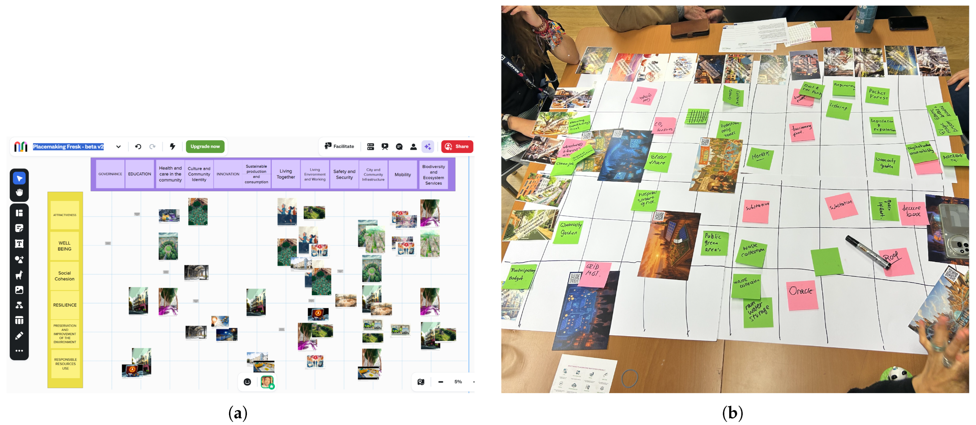
The workshop methodology uses a structured, time-bound format designed to optimise participant engagement and learning outcomes. The process consists of four distinct phases, each serving specific pedagogical and practical objectives. The workshop can take place both offline (
Figure 3b) and online (
Figure 3a).
In the Initial Orientation phase (30 min), participants are familiarised with the basic concepts (supported by Guidance cards) and divided into small groups of four to six people to create optimal conditions for collaborative learning. This phase includes a collaborative construction stage in which participants assemble the ISO 37101 framework map themselves from the framework cards, forming both the theoretical basis for the subsequent activities and the physical setup of the board game.
The Interactive Mapping phase (originally 90 min) is the central learning activity in which participants place action cards on the matrix board, justify their placement to peers, and identify connections across cells. Disagreements over card placement are resolved through organic group discussion, with facilitator intervention when needed, a design choice that itself reinforces the collaborative learning objectives. The original duration was intended to allow time for discussing both abstract sustainability visions and concrete actions relevant to the place under discussion. However, beta testing with participants from PROBONO direct ecosystem, and selected for interest in the topic and availability (online as offline, depending on PROBONO timings), revealed that the vision component was difficult for many participants to engage with and that attention levels dropped significantly after approximately 60 min. The phase was therefore reduced to 30 min and focused exclusively on mapping concrete actions, a trade-off that sacrifices breadth of discussion in favour of sustained engagement and sharper outputs.
During the Synthesis and Creative Integration phase (originally 30 min, later reduced to 20), teams engage in visual representation and synthesis of their findings, identifying gaps on the Placemaking Map and filling them in with new ideas for sustainable development. The final Reflective Dialogue and Action Planning phase (initially 30 min, later reduced to 15) facilitates knowledge transfer by placing these new ideas into an impact–feasibility matrix, so the groups can discuss actionable next steps that they present to other groups for feedback.
These adjustments to the workshop structure are first and foremost the result of feedback on timing and attention span. The original workshop had a three-hour-long programme, which, while comprehensive, proved demanding for many participants. Following multiple iterations we revised the content and cut the exercises that were hardest to follow (vision mapping) and reduced the time on other activities where appropriate based on the test sessions.
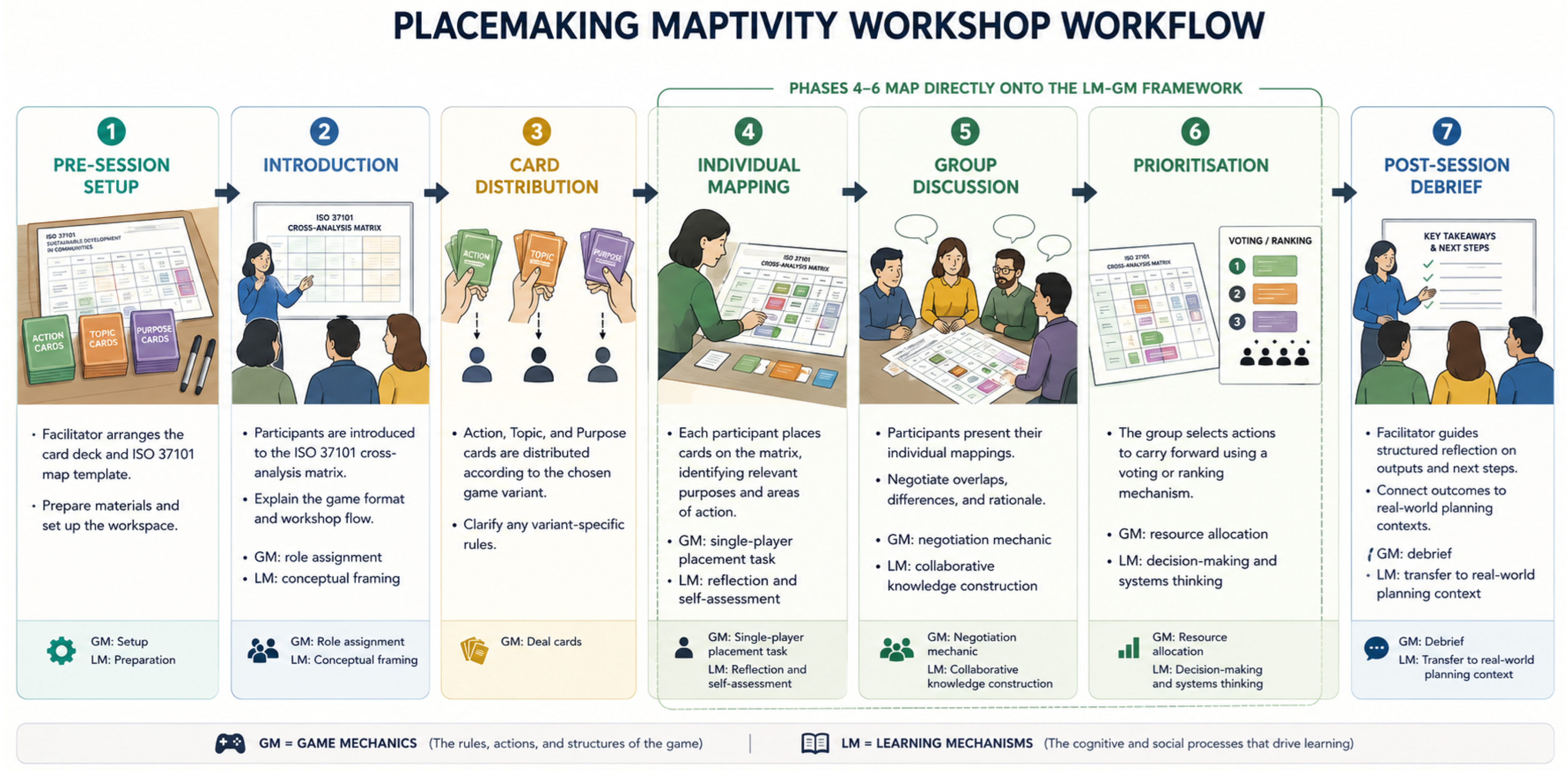
Participants follow systematic mapping protocols for card placement, relationship identification and justification.
This process incorporates elements of systems mapping and collaborative learning theory (
Figure 4).
2.4.2. Learning Mechanics–Game Mechanics Mapping and Learning Objectives
The five design principles above are operationalised through the Learning Mechanics–Game Mechanics (LM-GM) mapping framework [
16], which provides a structured method for aligning pedagogical intent with game design choices. In LM-GM, each game mechanic is explicitly linked to a targeted learning mechanic, ensuring that gameplay activities serve defined educational purposes rather than being incidental to them.
Table 2 presents this mapping for the core activities of the Placemaking Maptivity.
The mapping reveals a deliberate progression from lower-order to higher-order cognitive engagement: participants begin by exploring and observing the framework structure, move to reflection and articulation as they justify card placements, and conclude with analysis, evaluation, and strategic planning. This progression also corresponds to a shift from individual to increasingly collaborative activity, consistent with the collaborative learning theory underpinning the Climate Fresk methodology from which the Maptivity draws inspiration. While complementary frameworks such as MDA (Mechanics, Dynamics, Aesthetics) [
15] and the Serious Game Design Assessment Framework [
17] informed the overall design sensibility, particularly the attention to emergent group dynamics and the alignment between game purpose and mechanics, the LM-GM mapping was selected as the primary analytical lens because it provides the most direct traceability between game activities and intended learning outcomes.
The workshop is designed around three specific learning objectives. After participating, stakeholders should be able to:
- 1.
Identify multi-purpose contributions: recognise how a given urban project or action contributes to multiple ISO 37101 sustainability purposes simultaneously, moving beyond single-sector thinking.
- 2.
Map interdependencies: articulate connections between different areas of action within the ISO 37101 framework, developing a systems perspective on urban sustainability.
- 3.
Prioritise collaboratively: use the impact–feasibility matrix to negotiate and rank proposed actions as a cross-sector group, producing actionable outputs for neighbourhood planning.
These objectives are directly supported by the game mechanics identified in
Table 2: objective (i) is exercised through the card placement mechanic, objective (ii) through the gap analysis phase, and objective (iii) through the final prioritisation exercise.
Because ISO 37101 is a management system standard, its implementation follows the PDCA cycle. The current version of the Placemaking Maptivity primarily supports the “Plan” phase: participants identify sustainability objectives, map existing and proposed actions against the framework, and prioritise next steps. The gap analysis and impact–feasibility exercises also touch on elements of the “Check” phase by prompting participants to assess coverage and balance across the matrix. Future iterations could extend this further, for example, by revisiting a populated board after an implementation period to evaluate progress against the originally mapped actions.
2.5. Integration into Planning Processes
The Placemaking Maptivity method was developed to complement existing urban planning processes through integration into pre-planning, implementation support, and monitoring. During pre-planning, it facilitates coordination between stakeholders and a common understanding of sustainability objectives. During implementation, it provides a structured framework for ongoing stakeholder engagement, project evaluation, and gap analysis. The monitoring layer aligns with the indicators of ISO 37120:2018 and the cross-analysis guidance of ISO 37104:2019, providing a continuity between participatory workshops and quantitative performance tracking.
2.6. Beta-Testing Protocol and Evaluation Approach
The Placemaking Maptivity was evaluated through four iterative beta-testing rounds, consistent with the demonstration and evaluation phases of the DSR cycle. Each round involved a workshop of four to six participants in either fully online, fully in-person, or hybrid configurations. Iterations 1 to 3 used homogeneous stakeholder groups; iteration 4 deployed the methodology with a mixed-stakeholder international audience in a fictional-city setting, drawing action cards from the REEFLEX, PROBONO, and eFORT EU projects.
After each session, stakeholder feedback was gathered through informal post-workshop discussions. No validated instruments were used, and sample sizes were intentionally small at this formative stage; the evaluation is therefore best read as iterative artefact refinement rather than hypothesis-testing research. Findings from each iteration were used to revise the materials, workshop structure, and facilitation protocol before the next round, in line with established serious-game design practice [
28]. A more rigorous summative evaluation is set out in
Section 4.8.
3. Results
The development of the Placemaking Maptivity was iteratively refined through beta testing, which provided valuable insights into the tool’s usability, design evolution, and participant engagement across workshop configurations. This section presents the empirical results of these test sessions and the stakeholder reactions gathered. Selected use cases were inspired by EU-funded projects, including REEFLEX (Horizon Europe), PROBONO (Horizon 2020), and eFORT, to explore the applicability of the methodology in energy system and broader sustainability contexts.
3.1. Iterative Refinement Across Four Beta-Testing Rounds
The beta-testing process consisted of four iterations, each of which contributed to the further development of the Placemaking Maptivity.
Table 3 provides a comparative overview of the four rounds; the narrative subsections below expand on each iteration’s design rationale and participant experience.
3.1.1. Iteration 1: Action Cards and Initial Challenges
In the first iteration, which involved four participants, a deck of action cards representing projects and activities in a particular neighbourhood was presented. Each card pointed to relevant ISO framework purposes and guided participants to select projects that best aligned with their neighbourhood’s sustainability vision.
Participants found that linking real-world projects to ISO-defined sustainability purposes was thought-provoking and led to a deeper understanding of how real-world activities contribute to multiple sustainability goals. However, the session did not provide the intended overview of sustainability projects, nor did it promote the required level of shared reflection and knowledge building.
3.1.2. Iteration 2: Introducing the Placemaking Map
To address these shortcomings, the Placemaking Map was introduced in the second iteration in an online session with five participants. The structure of the workshop was redesigned in line with the Climate Fresk to improve collaborative learning. The action cards were also updated: instead of defining the impact areas in advance, they were left open to encourage participants to think about them. The session still used a pre-made 12 × 6 matrix as the game board.
The updated structure resulted in a clearer overview of sustainability projects as participants mapped the action cards to the relevant intersections on the Placemaking Map. However, participants reported difficulties in understanding and applying the sustainability framework as presented on the pre-made Placemaking Map.
3.1.3. Iteration 3: Collaborative Framework Construction
In response to this feedback, the third iteration included a dedicated session to help participants engage with the sustainability framework by creating their own Placemaking Map, that is, assembling the board from the twelve framework cards mapping the areas of action and the six framework cards representing the purposes. This exercise provided an interactive introduction to the framework and facilitated deeper discussions about sustainability concepts, with a more important focus on the role of the facilitator [
29].
This approach may have helped in promoting conceptual understanding, reflection, and discussion among participants, encouraging players to actively create their own Placemaking Map, leading to participants developing a more intuitive understanding of sustainability principles and their real-world applications.
3.1.4. Iteration 4: Mixed-Stakeholder International Setting
The final iteration tested the Placemaking Maptivity both online and offline, and introduced a new setup that demonstrated the application of the Maptivity for a mixed stakeholder group instead of stakeholders belonging to the same municipality or neighbourhood. This iteration took place within an international hybrid conference (ENLIT Europe), facilitating the workshop simultaneously for a digital group of participants and a physically participating group of mixed stakeholders. Both groups applied the imaginary setup of stakeholders temporarily “living together” in a fictional city. The specific action cards of the fictional destinations were borrowed from real EU projects, including PROBONO, REEFLEX and eFORT, and their real activities.
In this workshop, participants started by getting familiarised with their “home”, the fictional city of Gotham. Here, they were introduced to ongoing actions in the city through examples inspired by REEFLEX use cases, including digital twin interfaces, AI-driven microgrid solutions, and smart energy coordination mechanisms. These examples represented complex interactions between energy systems, infrastructure, and user behaviour within an urban context. After creating the Placemaking Map and familiarising themselves with these and other actions from EU projects, participants placed the various action cards on the map in the mapping phase.
An emerging insight was that the similar focus areas of the project examples, and the lack of projects with greatly divergent focus areas, were reflected on the map very visibly. For instance, the REEFLEX-inspired examples were perceived by participants as strongly contributing to the Resilience sustainability goal and were associated with enabling factors such as Innovation and City and Community Infrastructure. This means that the overall coverage of the map depends on what kind of projects and which specific focus areas are brought as examples, which may unintentionally create bias or justify potentially missing areas, since the examples may not cater for the same city needs as in a real-world context. It also means that the creative brainstorming on new necessary actions for implementation might become an ungrounded phase or element of this setup. This would look differently in a real-world municipal setting.
Overall, the workshop demonstrated that the Placemaking Maptivity can be applied in two distinct configurations: (a) for specific municipalities working with their local context of sustainable placemaking and specific existing actions and (b) for mixed stakeholder groups working with fictional cities and imported action cards.
Cross-Round Reflection
Across the four iterations, the card structure, matrix layout, and overall phase sequence (orientation → individual mapping → group discussion → prioritisation → debrief) converged to a stable configuration by Round 4. The primary design decisions that reached closure were the open-ended card format (Round 1), the introduction of the Placemaking Map as a shared board (Round 2), and the collaborative assembly of that board as an orientation mechanic (Round 3). The principal remaining design variables are: the depth of the facilitator-led introduction required for non-expert participants; the management of time pressure in the prioritisation phase for larger or more heterogeneous groups; and the mechanism for translating game outputs into actionable planning commitments after the session. These open questions define the agenda for the next design cycle.
3.2. Stakeholder Feedback Across Iterations
Stakeholder feedback was collected through informal post-workshop discussions at the end of each session. No validated instruments were used, and sample sizes were small (four to six participants per iteration); the findings reported here should therefore be read as preliminary observations from a formative evaluation rather than as evidence of measured learning gains.
With that caveat, several consistent themes emerged. Participants reported a better understanding of the complexities of urban sustainability and, in particular, of how individual projects can serve multiple sustainability purposes simultaneously. In the informal verbal feedback, all respondents in the rounds where this item was included selected “very engaging” or “extremely engaging” when asked to rate the methodology’s ability to facilitate learning. Given the small sample sizes and the absence of a validated scale, these responses are treated here as indicative rather than summative. Still, in the post-session verbal exchanges, participants consistently reported positive assessments of the methodology’s ability to facilitate learning. The visual and interactive nature of the methodology was particularly praised across sessions.
Three further observations recurred across sessions. First, the importance of skilled facilitation was clear, particularly in managing time constraints and ensuring balanced participation. Second, the initial learning curve associated with the ISO 37101 framework indicated the need for more robust workshop preparation materials. Third, participants expressed a desire for more examples from the local context and highlighted the importance of adapting to specific urban contexts.
The mixed-group sessions led to particularly rich discussions: participants from different sectors reported new insights into the perspectives and priorities of other stakeholders, and several spontaneously described the workshop as a useful boundary-spanning exercise.
4. Discussion
4.1. What the Maptivity Adds to Participatory Sustainability Planning
The four iterations together provide preliminary evidence that the Placemaking Maptivity addresses a specific and previously underserved niche in the participatory planning toolkit: the operationalisation of an internationally recognised sustainability management standard into a format that mixed-expertise audiences can engage with directly. Existing serious games in urban planning, such as Metropolis [
8], the Mobility Game [
9], and the Sustainability Futures Game [
10], foreground simulation, scenario play, and emergent dynamics. Digital planning-support tools offer a further complementary strand, typically optimised for data integration and scenario modelling rather than participatory sense-making [
30]. The Maptivity takes a different route, using the ISO 37101 cross-analysis matrix itself as the game board and the postcard-format action cards as the tokens. The result is a tool whose outputs are organised according to an internationally recognised assessment taxonomy, lowering the conceptual distance between participatory workshop and formal planning processes, in itself a relationship that prospective evaluation will need to examine.
Two claims about the Maptivity’s relationship to analytical rigour should be distinguished. First, the game mechanic preserves the structural logic of the ISO 37101 matrix: participants engage with the same six-purpose by twelve-area-of-action framework as the original standard, and outputs can be read back against it. In this structural sense, the Maptivity is ISO 37101-structured. Second, however, we do not claim that participation in the game produces analysis of equivalent rigour to professional ISO 37101 assessment, which involves contextual analysis, indicator selection, and iterative validation that the game format does not replicate. The Maptivity functions as a structured discussion scaffold that introduces diverse stakeholders to the ISO 37101 analytical lens and generates a shared, framework-organised view of proposed actions—a meaningful contribution that is distinct from, and complementary to, formal standards-based assessment.
The three learning objectives—identifying multi-purpose contributions, mapping interdependencies, and prioritising collaboratively—were observably exercised across all four iterations. Facilitator session notes record that participants shifted from single-purpose framings of projects (“the bike path is mobility”) towards multi-purpose recognition (“the bike path is mobility, well-being, and environmental preservation”) over the course of a single workshop. This pattern, recorded in facilitator notes rather than formally measured, is consistent with the design intent encoded in the LM-GM mapping (
Table 2); formal measurement of these shifts is a priority for the next evaluation phase.
4.2. Usability and Engagement Evidence Versus Planning Effectiveness
A key methodological distinction must be drawn between the evidence the current study provides and the evidence it does not. The four rounds of beta testing document participant engagement, the usability of the card-and-map format, and the iterative resolution of design problems—all evidence of the artefact’s feasibility as a workshop tool. They do not, however, provide evidence that the tool produces more rigorous sustainability analysis, better planning decisions, or deeper learning outcomes than alternative approaches.
These two categories of evidence require different evaluation designs. Usability and engagement can be assessed through facilitated testing with small purposive samples, as carried out here. Effectiveness requires pre/post designs, comparative conditions, independent facilitation, and validated instruments. The present study contributes the former. The latter is proposed as the primary agenda for the next research phase and is elaborated in the evaluation roadmap (
Section 4.8).
This distinction is consistent with the formative evaluation logic of Design Science Research: demonstrating that an artefact is feasible, engaging, and iteratively improvable is a meaningful and necessary prior step before investing in the more resource-intensive evaluation of outcome effectiveness [
26].
4.3. Facilitation, Timing, and Contextual Adaptation as Success Factors
Across the four iterations, three success factors were consistently apparent. Facilitation skill matters substantially: the third iteration’s switch to a collaboratively constructed board only worked because the facilitator could prompt and frame the framework discussions. Timing discipline matters: the reduction from three hours to a tighter programme reflected real attention-span constraints, and the trade-off (less abstract vision discussion, more concrete action mapping) appears to have been worth making. Contextual adaptation matters most of all: the fourth-iteration insight that imported EU-project cards bias the coverage map is an important caveat for any mixed-stakeholder deployment.
These observations are not novel in the serious-game literature [
20,
29], but they translate into specific operational requirements for the Maptivity. They also imply that simply distributing the card deck is insufficient—the artefact and its facilitation protocol are inseparable.
4.4. Facilitator Dependency and Transferability
A critical structural feature of the current Maptivity design is its dependence on skilled facilitation. All four beta-testing rounds were led by members of the design team with direct expertise in the ISO 37101 framework and participatory planning facilitation. This expertise shaped the delivery of the game introduction, the management of group dynamics during the card-placement and negotiation phases, and the translation of game outputs into planning language in the debrief.
We distinguish here between two types of facilitation contribution. Artefact-driven facilitation is structured by the cards, matrix, and protocol and could in principle be delivered by a trained non-specialist. Expert-driven facilitation draws on ISO 37101 knowledge and participatory planning expertise that is not yet embedded in the artefact. The current design relies substantially on the latter.
This reliance limits the tool’s current transferability: it cannot yet be described as a self-contained, facilitator-independent planning method. A priority for the next design cycle is the development of richer embedded guidance—facilitator prompt cards covering common participant questions, decision rules for edge cases in the card-placement phase, and a structured debrief protocol—that would reduce the knowledge demands on the facilitator and support delivery by practitioners without ISO 37101 expertise [
20]. This design goal is also what distinguishes the Maptivity’s development trajectory from turnkey digital tools: the embedded facilitation structure, once refined, is itself a transferable design contribution [
30].
4.5. Critical Reflection on the ISO 37101 Framework as Participatory Scaffold
The Placemaking Maptivity uses the ISO 37101 cross-analysis matrix as its structural scaffold. This choice is grounded in the framework’s international recognition, its coverage of multiple sustainability dimensions, and its explicit focus on sustainable community management—making it directly relevant to neighbourhood-scale planning. However, the use of a pre-defined international standard as a participatory scaffold raises methodological questions that deserve critical attention.
First, the matrix’s fixed structure (six purposes × twelve areas of action) may constrain the emergence of sustainability framings that are locally specific and not captured by the standard’s categories. Communities operating under particular cultural, ecological, or institutional conditions may find that their most pressing sustainability concerns do not map cleanly onto the matrix’s taxonomy. The game mechanic, by structuring discussion around the matrix, may inadvertently marginalise these concerns rather than surfacing them.
Second, the abstraction level of ISO 37101 categories poses accessibility challenges for participants without sustainability planning backgrounds. Beta testing across all four rounds confirmed that a facilitator-led introduction to the framework was necessary; without it, participants struggled to interpret the matrix columns and rows. Whether the framework can be made sufficiently accessible for genuinely non-expert community engagement without specialist facilitation remains an open question.
Third, the use of a globally standardised framework may normalise particular sustainability priorities and framings at the expense of context-specific or dissenting perspectives. Standards reflect the consensus of their drafters at a point in time; using them as participatory scaffolds risks importing those consensus framings into local planning discussions in ways that are not made visible to participants.
We do not conclude from these observations that the ISO 37101 framework is inappropriate as a basis for the Maptivity. Rather, we identify these as genuine design tensions to be addressed in the next iteration—for example, through the inclusion of blank “custom” cards and matrix cells that allow participants to supplement or contest the standard’s categories with locally specific framings.
4.6. Limitations of the Current Evaluation
Several limitations of the current evaluation should be acknowledged. Sample sizes across the four iterations were small (four to six participants per session, with one mixed-stakeholder hybrid session involving a larger but heterogeneous group). Feedback was collected through post-workshop discussion rather than validated instruments such as systems-thinking assessments or collaboration self-efficacy scales. No control condition was used, so reported learning gains cannot be causally attributed to the methodology.
All four beta-testing rounds were facilitated by members of the design team—the same researchers who designed the artefact. This introduces a risk of facilitator bias in the delivery of instructions, management of group dynamics, and interpretation of participant responses. Participants were also aware that they were evaluating a prototype developed by the research team, which may have produced socially desirable feedback. No longitudinal data were collected, so it is not possible to assess whether the shifts in participant framing observed during workshops translated into sustained changes in planning practice or decision-making. All evidence of effectiveness rests on self-reported perceptions rather than independently verified planning outputs or objective learning assessments.
The mixed-stakeholder fictional-city setting introduced an additional confound: as discussed in
Section 3.1.4, the imported EU-project action cards clustered thematically and may have biased participants’ perception of which sustainability dimensions were well- or under-covered. These limitations frame the formative character of the present results and motivate the more rigorous evaluation protocol described in
Section 4.8. The findings support the feasibility and usability of the Maptivity design; they do not constitute a validation of its effectiveness as a planning or learning intervention.
4.7. Scaling Potential: Design Hypotheses and Research Directions
The formative results suggest that the Placemaking Maptivity is a plausible candidate for broader implementation in urban planning and that its integration of an international standard with a participatory game mechanic addresses a gap in the existing toolkit. Whether it can deliver these benefits reliably across a wider range of planning cultures, institutional settings, and facilitator profiles is a hypothesis that requires testing through prospective evaluation studies. The conditions for transferability remain to be established before scaling claims can be substantiated.
Several contextual factors are expected to moderate the tool’s performance in broader deployment, and each constitutes a hypothesis for future research. First, facilitator capacity is expected to be a critical prerequisite: without a facilitator capable of explaining the ISO 37101 framework, managing group dynamics, and helping participants connect game outputs to real planning decisions, the tool’s value is likely to be substantially reduced. Second, workshop scale may affect the depth of discussion that can be achieved within the game’s time constraints; groups larger than approximately fifteen participants may require modification of the card-selection and prioritisation phases, a proposition to be tested rather than assumed. Third, institutional context, particularly the degree to which participants perceive the workshop as connected to actual decision-making processes, is expected to influence the seriousness with which participants engage with the prioritisation phase. Fourth, cultural familiarity with collaborative game formats varies across participant communities and may require adaptation of the introductory framing.
These factors are presented here as design hypotheses informing the next development and evaluation cycle, not as conclusions of the present study. Recommendations for that cycle include: the development of a comprehensive facilitator training programme addressing both ISO 37101 content knowledge and facilitation craft; the establishment of quality-control mechanisms across deployments; and the creation of regional adaptation guidelines. The evidence base for asserting broader impact will require comparative studies across municipal and mixed-stakeholder settings with independent facilitation.
4.8. Future Developments and Evaluation Roadmap
Work is underway to create more robust facilitation training materials and to expand the library of context-specific case studies. A digital delivery platform will be enhanced to support virtual workshops and improve data collection for research purposes. Customisation efforts include developing versions for specific urban contexts and challenges, including non-European contexts, and mechanisms to integrate the Maptivity with other planning tools and methods, such as scenario planning and impact assessment.
A further specific development priority is the operationalisation of the custom card mechanism identified in
Section 4.5: concretely, this involves designing a set of blank action cards and configurable matrix axis labels that allow facilitators and participants to introduce locally specific sustainability priorities not captured by the ISO 37101 taxonomy. Piloting this mechanism in two or three municipal settings with distinct local sustainability profiles will allow assessment of whether it reduces the normalisation risk identified in
Section 4.5 without undermining the framework’s comparative and integrative functions.
A key priority is the design of a more rigorous evaluation protocol. Future studies will employ pre- and post-workshop questionnaires with validated scales (for example, systems-thinking assessments and collaboration self-efficacy measures), larger and more representative samples, independent facilitation, and comparative designs across municipal and mixed-stakeholder settings. The evaluation framework proposed by Mayer et al. [
28] for serious games will serve as a structuring reference. Where possible, evaluations will also revisit workshop outputs after an implementation period, supporting the "Check" phase of the PDCA cycle and providing longitudinal evidence on whether mapped actions actually translate into neighbourhood-level change.
5. Conclusions
This paper has presented the Placemaking Maptivity, a card-based serious game that operationalises the ISO 37101 cross-analysis matrix as a shared analytical scaffold for participatory neighbourhood sustainability planning. Through four iterative rounds of Design Science Research-driven beta testing, in online, in-person, and mixed-stakeholder international configurations, the artefact was refined into a workshop format that introduces the ISO 37101 analytical lens to mixed-expertise audiences, supports engagement with the standard’s structural logic, and generates a shared, framework-organised view of proposed neighbourhood actions. Each game mechanic is explicitly tied to a learning objective through the LM-GM framework, providing a replicable design methodology for standards-aligned serious games in urban planning.
The current evaluation is formative in character: it provides preliminary evidence of the artefact’s feasibility and usability, not evidence of its effectiveness as a planning or learning intervention. In its current form, the Maptivity requires trained facilitation and cannot yet be considered a self-contained, facilitator-independent method; reducing this dependency through embedded guidance materials is a stated priority for the next design cycle.
Sample sizes are small, instruments are unvalidated, all sessions were facilitated by the design team, and the evidence rests on self-reported participant perceptions. The Maptivity preserves the structural logic of the ISO 37101 matrix in its game mechanic; it does not claim to produce analysis equivalent in depth or rigour to professional standards-based assessment. A more rigorous summative protocol, drawing on established serious-game evaluation frameworks, is proposed for future studies, together with extensions to the PDCA Check phase through longitudinal follow-up. Subject to such validation, the Placemaking Maptivity has the potential to support a broader practice of integrated, cross-sector sustainability planning at the neighbourhood scale, bridging the gap between abstract international frameworks and the concrete realities of urban transformation.