Disaster Risk Identification and Prevention Strategies for Cultural Tourism Characteristic Towns: A Case Study of Zhangguying Town, Hunan Province


Abstract
1. Introduction
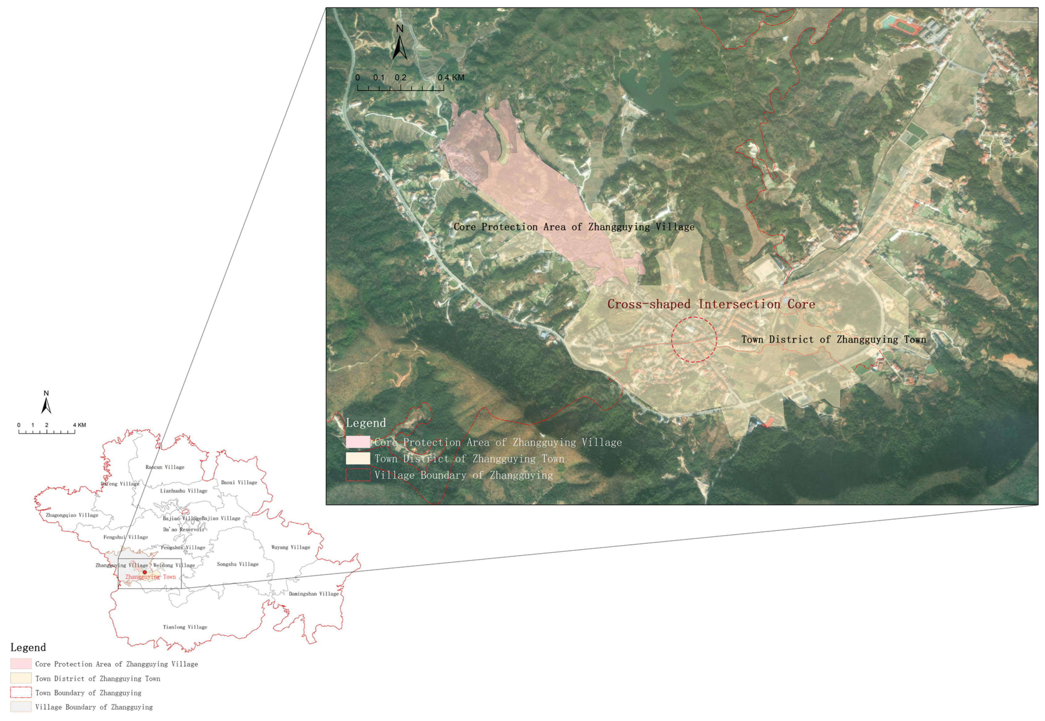
2. Study Area: Zhangguying Town
3. Disaster Characteristics and Influencing Factors in Zhangguying Town
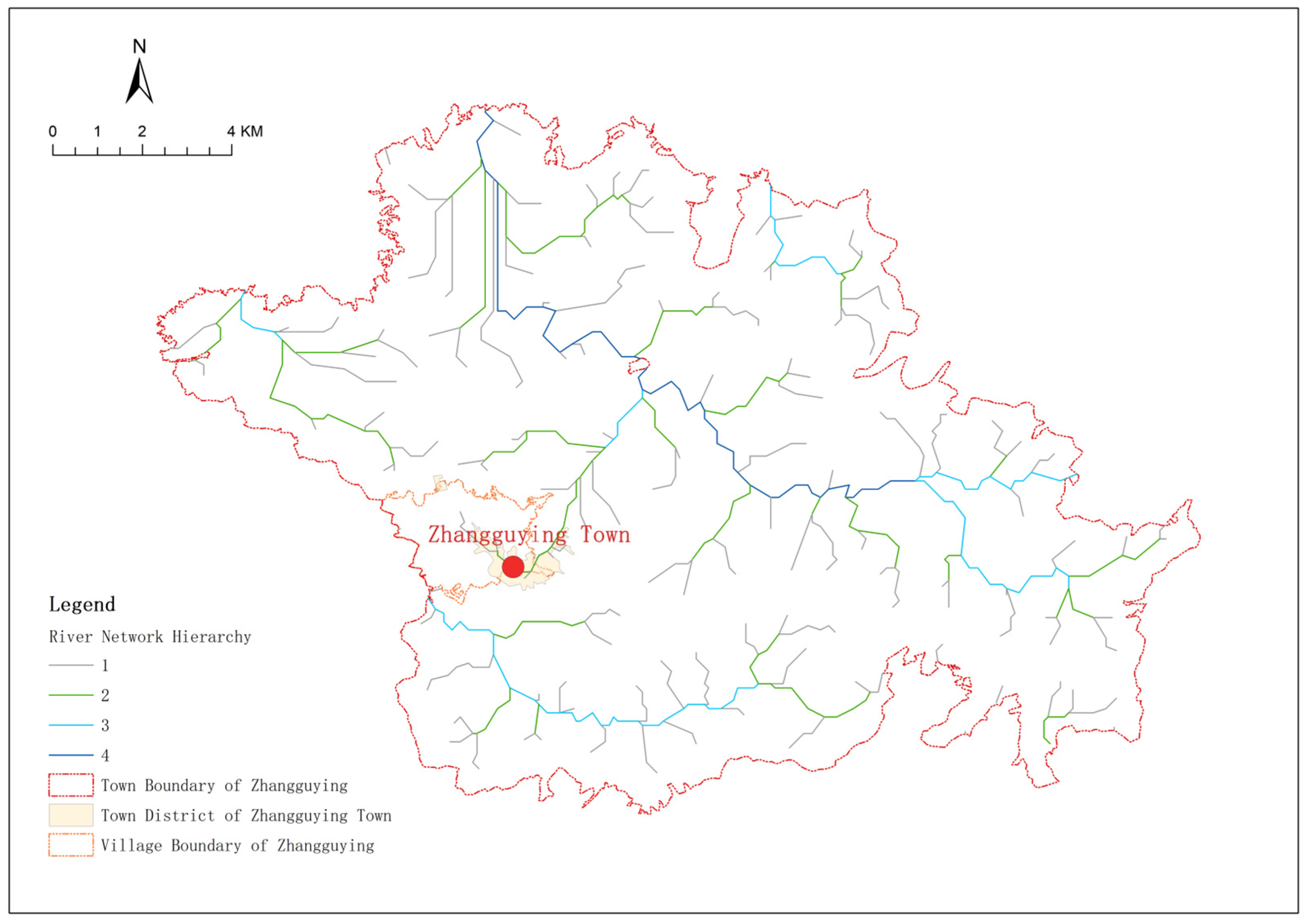
3.1. Concentrated Rainfall and Susceptibility to Floods and Geological Hazards
3.2. Compact Historic Settlement Space and Fire Risks
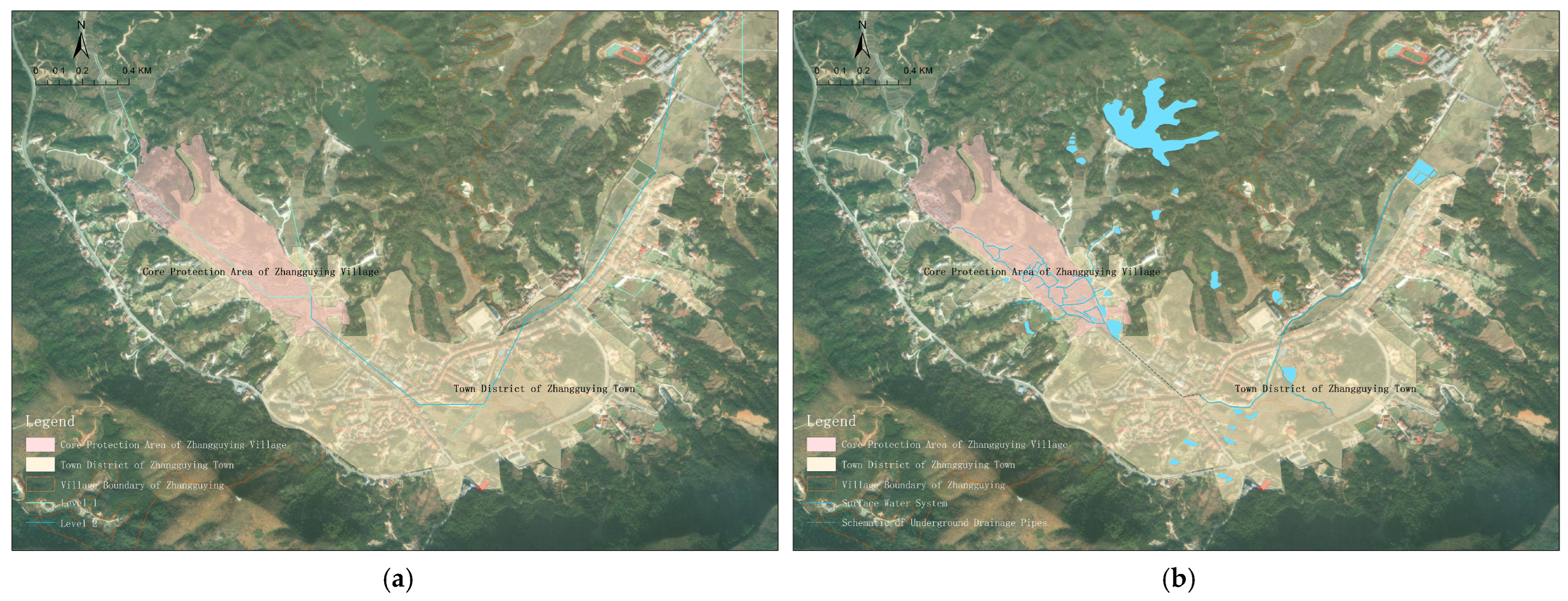
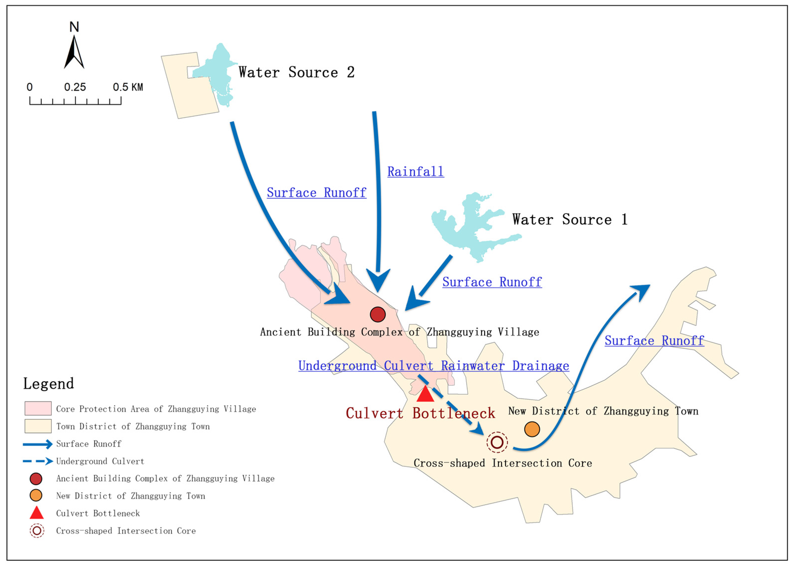
3.3. Altered Surface Hydrological Pathways and Reduced Stormwater Drainage Efficiency
4. Current State and Development Dilemmas of Comprehensive Disaster Prevention Planning in Zhangguying Town
4.1. Current State of Comprehensive Disaster Prevention Planning in Zhangguying Town
4.1.1. Geological Hazards
4.1.2. Meteorological Disasters
4.1.3. Fire Hazards
4.1.4. Earthquake
4.2. Development Dilemmas of Comprehensive Disaster Prevention in Zhangguying Town
- (1)
- Predominant focus on single-hazard protection, neglecting the risk superposition effects arising from disaster chains. The disaster prevention planning in Zhangguying Town remains centered on the layout of single-hazard protection facilities, exhibiting limitations such as low facility utilization efficiency, rigid planning transmission, and passive post-disaster emergency response. For instance, within the “heavy rainfall–mountain torrents–geological hazards” disaster chain, the occurrence of geological hazards exhibits a certain time lag relative to rainfall. During heavy rainfall events, proactive measures such as real-time monitoring of slope deformation and identification of potential debris flow material sources within the watershed are necessary to enhance preventive protection. Moreover, there is a lack of synergistic linkage mechanisms among protection facilities for different hazard types. For instance, rainfall monitoring data are not integrated in real time into the geological hazard early warning platform, reducing the timeliness of chain-response actions. Furthermore, natural disasters and anthropogenic factors often produce superposition effects: during peak seasons, tourist vehicles are densely parked along the town’s main roads, with some sections encroaching on emergency access routes; temporary structures such as awnings and advertising signs installed by street-front shops to meet tourism demand can easily become secondary hazard sources during high winds or heavy rain; and the increased domestic waste and cooking fume emissions resulting from tourist congregations further exacerbate the risk of drainage pipe blockages.
- (2)
- Excessive emphasis on large-scale construction of disaster prevention facilities, with insufficient in-depth analysis of disaster formation mechanisms. In response to the continuously increasing flood risk in recent years, Yueyang County constructed the Dadong River Mountain Torrent Flood Control Project to dredge flood discharge channels within the county, which has improved stormwater drainage capacity in Zhangguying Town to some extent. However, this approach fails to fundamentally solve the waterlogging problem in the town proper, leaving both the historic architectural complex and the newly developed area exposed to flood erosion risks. It is necessary to analyze the actual construction conditions and hydrological pathways of the town proper, thoroughly investigate the formation mechanisms of flood disasters in Zhangguying Town, and enhance stormwater drainage efficiency. As demonstrated by the ArcGIS analysis and spatial overlay presented earlier, the core bottleneck of drainage in the town area lies in the insufficient conveyance capacity of the covered culvert, which is precisely located at a critical confluence node—rather than being a capacity issue of downstream flood discharge channels. This mechanistic understanding has not yet been translated into specific engineering retrofit measures.
- (3)
- Structural deficiencies in evacuation channels within complex settlements, with insufficient research on pedestrian evacuation routes from residential spaces to emergency shelters. Zhangguying Town has planned a two-level evacuation shelter system comprising emergency shelters and fixed shelters, along with a primary level of emergency evacuation routes. Among these, the planned evacuation routes are relatively high-level, relying on highways, and essentially function as rescue evacuation channels primarily ensuring the passage of rescue and evacuation vehicles between emergency shelters and fixed shelters. However, insufficient attention has been paid to mapping pedestrian evacuation routes from residential spaces to emergency shelters. Particularly within Zhangguying Village, the ancient Dawu architectural complex features complex building morphology with interconnected structures and numerous alleyways. In the event of a disaster, the selection of evacuation routes significantly impacts evacuation efficiency. According to survey data, the average width of major alleyways within the ancient complex is only 0.8 m, with multiple bottleneck sections below 0.5 m in width and blockage points caused by miscellaneous item stacking. These micro-scale obstacles will severely impede evacuation speeds during disasters. During peak seasons, the one-way pedestrian flow density along the core tourist routes within the ancient complex can reach several thousand person-times per day, further reducing the actual passage capacity of these routes. Evacuation paths that are viable on regular days may become ineffective under holiday conditions, necessitating the establishment of differentiated evacuation route management schemes for regular days and peak seasons separately.
5. Comprehensive Disaster Prevention Planning Strategies for Zhangguying Town in the Context of Urban-Rural Cultural and Tourism Integration
5.1. Strengthening the Preventive Capacity of Cascading Disaster Measures
- (1)
- Establish a chain-integrated monitoring and early warning system. Priority should be given to establishing a real-time data-sharing platform that integrates rainfall monitoring and geological hazard monitoring data, with joint early warning thresholds defined to enable a transition from “individual single-hazard responses” to “chain-integrated collaborative early warning.” When hourly rainfall exceeds 50 mm and the slope displacement rate exceeds 2 mm/d, a geological hazard warning shall be automatically triggered, accompanied by the simultaneous activation of broadcast evacuation within the historic architectural complex.
- (2)
- Deploy chain-disaster prevention facilities by functional zone. In the core historic architectural protection area, slope displacement monitors shall be installed upstream of the ancient architectural complex, linked with the rainfall monitoring station along the Weixi River. Additionally, water level gauges and emergency drainage pumps shall be added within each courtyard to ensure that manual auxiliary drainage can be activated when water accumulation exceeds 0.3 m. In the newly developed town area, priority shall be given to ensuring unobstructed drainage channels. Grates shall be installed at the entrance of the covered culvert at the cross-shaped intersection to intercept debris, with regular cleaning scheduled. Liquid level monitors shall be installed at key nodes of the underground pipe network, automatically sending early warning signals to upstream pumping stations when the water level reaches 80% of the designed capacity. Along the main tourist route (from the scenic area exit to the cross-shaped intersection), emergency supply boxes shall be placed every 100 m on both sides of the route, serving as “front-end response points” for chain disasters to ensure that tourists can access basic self-rescue tools immediately upon disaster occurrence.
- (3)
- For the flood–geological hazard chain, a response mechanism of “pre-disaster prevention, during-disaster response, and post-disaster recovery” should be established. Prior to disasters, engineering protection at geological hazard prone areas should be strengthened, key flood discharge channels should be widened and dredged, and real-time monitoring systems for rainfall and geological dynamics should be established, supplemented by manual inspections to form a dual early warning system. During disasters, a joint command mechanism for cascading disasters should be established to monitor real-time rainfall and changes at geological hazard sites, and phased evacuation plans should be developed for residents in different areas to reduce congestion on single evacuation routes. Following disasters, drainage and structural maintenance of ancient buildings affected by flood inundation should be prioritized to prevent secondary damage to heritage structures from accumulated water, and dedicated emergency repair funds and teams should be established.
5.2. Developing Micro-Scale Disaster Prevention Renewal Strategies
- (1)
- For the core historic architectural protection area, fire prevention shall be the primary focus. A full-coverage retrofitting program of “metal conduit for electrical wiring + leakage protection devices” shall be implemented. Priority shall be given to upgrading the public electrical circuits of the three major architectural clusters—Dangdamen, Wangjiaduan, and Shangxinwu—followed by progressive upgrades to the household service lines of individual residences. Smart smoke detectors shall be installed in key courtyards (e.g., assembly halls, ancestral halls, and other places where people gather) to enable early fire detection. Micro-retrofitting shall be carried out at 12 width-bottleneck sections, involving the removal of unauthorized partitions and the reorganization of miscellaneous item stacking, with priority given to opening lateral connecting passages that link main alleyways to external arterial roads.
- (2)
- For the core historic architectural protection area, flood prevention shall be the primary focus. Traditional drainage ditches within the ancient architectural complex shall be restored and dredged, and the fire ponds (yanhuo tang) shall be desilted to restore their flood detention capacity. The external wall bases of ancient buildings along the Weixi River side shall be treated with waterproof coating to reduce the erosion of wall foundations caused by flood inundation.
- (3)
- For the newly developed town area, flood prevention shall be the primary focus. The internal diameter of the covered culvert from the scenic area exit section shall be expanded from 0.6 m to 1.2 m, and two additional surface drainage open channels shall be constructed at the town’s cross-shaped intersection to divert flow southward to the drainage canal. In newly developed contiguous areas, permeable pavement and rain gardens shall be promoted, with the impervious surface ratio in new development zones controlled below 30%.
- (4)
- For the main tourist routes and tourist congregation areas, multilingual disaster prevention signage systems shall be installed at high-density tourist nodes such as the scenic area entrance, the Hundred-Step Three Bridges, and the Panxi Corridor. Emergency broadcast speakers shall be placed every 200 m along the main tourist routes, connected to the town-level emergency command platform.
5.3. Establishing a “Point-Line” Coordinated Multi-Scale Structural Disaster Prevention Spatial System
- (1)
- Evacuation route optimization. Based on the existing alleyway network of Zhangguying Town, pedestrian evacuation behavior analysis shall be conducted using ant colony algorithms on the Pathfinder platform [25], through which the optimal combinations of pedestrian refuge routes shall be identified. On this basis, targeted micro-retrofitting shall be carried out on the identified critical bottleneck sections (alleyway nodes with existing widths below 0.8 m), and multilingual illuminated directional signs shall be installed along the primary evacuation flow directions, forming a pedestrian escape network that is compatible with the spatial morphology of the ancient architectural complex.
- (2)
- Shelter configuration. For the core protection area, the plaza in front of Dangdamen, the sunning ground at Wangjiaduan, and the open space in front of Shangxinwu shall be designated as distributed evacuation assembly sub-nodes within the three clusters, ensuring 3-min walking accessibility. For the newly developed town area, the Zhangguying School playground and the new village market shall be designated as fixed shelters. For the main tourist routes, small refuge bays (with a minimum width of 1.5 m) shall be placed every 200 m along the Panxi Corridor, serving as relay points for temporary refuge and pedestrian flow diversion.
- (3)
- Tiered response protocols. Three-tier protocols shall be formulated according to operational scenarios: Under normal-day mode, routine inspections and facility maintenance shall be conducted, with weekly checks of evacuation route accessibility, monthly testing of fire protection facility functionality, and quarterly household visits for resident disaster prevention education. Under holiday peak mode, additional evacuation guides shall be deployed at key nodes within the ancient architectural complex, backup shelters shall be activated, and one-way pedestrian flow control shall be implemented. Real-time pedestrian flow monitoring shall be conducted through the scenic area ticketing system and infrared counting devices at major attraction entrances. When the instantaneous pedestrian flow within the ancient architectural complex exceeds 2000 persons, or when a single alleyway exceeds 150 persons per 100 m, flow-restriction broadcasts shall be automatically triggered and a phased release mechanism shall be initiated. Under disaster warning mode, upon receipt of early warnings for heavy rainfall, flash floods, or geological hazards, the chain-disaster emergency command center shall be activated with 24-h joint duty staffing. When the warning level reaches orange or above, zoned and phased evacuation shall be organized following the principle of “tourists first, then residents; low-lying areas first, then high ground,” with simultaneous activation of emergency material supply points to ensure that food, drinking water, and medical supplies can sustain 48 h of support.
6. Conclusions and Discussion
Author Contributions
Funding
Institutional Review Board Statement
Informed Consent Statement
Data Availability Statement
Conflicts of Interest
References
- Sun, J.X. The theoretical efficacy of cultural tourism development in driving urban-rural integration. Tour. Trib. 2024, 39, 1–3. [Google Scholar] [CrossRef]
- Li, Y.J.; Zhang, J.J. The endogenous development of characteristic towns from the perspective of historical and cultural heritage. Ningxia Soc. Sci. 2019, 3, 212–216. Available online: https://kns.cnki.net/kcms2/article/abstract?v=4K0tw7BxpDEEg1O7VHOw_1mIhFUHec4Vd-sZR8Ay3p0L2eUjmdhLctggDRBwdJhASHGJGJHSoPC1ml6kPYOm4PlkesH7KOY8zG2Zr_8Oe5xIkZacFse_F4f_lIv0HZ2kRHp9ehe1GUxOOAxQHaXvInR2XZJbOr4ovvromwRIheC-2REjpMwNzw==&uniplatform=NZKPT&language=CHS (accessed on 26 June 2026).
- Zhai, H.; Li, Y.W.; Yang, H.G.; Liu, X.Q. The value of vernacular landscape in cultural tourism-oriented characteristic towns and its integrated conservation strategies: A case study of Shaxi Ancient Town, Dali, Yunnan. China Anc. City 2020, 5, 85–92. [Google Scholar] [CrossRef]
- Li, Z.Q. Spatial reconstruction and path exploration of characteristic small towns: From the perspective of urban-rural “magnet-type” integrated development. J. Nantong Univ. (Soc. Sci. Ed.) 2019, 35, 50–57. Available online: https://kns.cnki.net/kcms2/article/abstract?v=4K0tw7BxpDF5RjawucSqkx_HPZTH4N-G5uUJVMoZYAt6ryRw_LxOsiLlVsNGQwC9dJ9xyA15bQUNPHouVwBl-Uz5I9VTB-B9a-5D73Ft3D-exCwOnwpeG5fu_yeP8Or5gL2-eQF5gX6BBvh6GntUajPiSkp7qGooEFKgYlfRRy4lBk9ppH9Kjw==&uniplatform=NZKPT&language=CHS (accessed on 26 June 2026).
- IPCC. Climate Change 2021: The Physical Science Basis; Cambridge University Press: Cambridge, UK, 2021. [Google Scholar] [CrossRef]
- Hu, Y.G.; Han, T.K. Analysis of the causes of disorderly expansion of small town land use. Dev. Small Cities Towns 2004, 2, 86–88. Available online: https://kns.cnki.net/kcms2/article/abstract?v=4K0tw7BxpDGi-cViRfsRqyBzS0I2BVKW6FdgQ4XYZU7Ia7BijIhoIKdpBdQ_T2lzGcrzu2keH_YMDBwpqI1KK5CXEuI_OOQd_J9ADArgIWE-vvGtB0l2aYzJbrvEEseS1O4zZrg7Cnqt4uVkFCG7LqINgOOB7O4Fa01cC-BfrUaahE7iNSrCCg==&uniplatform=NZKPT&language=CHS (accessed on 26 June 2026).
- Ning, S.S.; Li, L.; Wang, W. A study on the vitality evaluation of characteristic small towns from the perspective of big data on pedestrian flow: A case study of nine characteristic small towns in eastern China. Dev. Small Cities Towns 2018, 36, 43–48. Available online: https://kns.cnki.net/kcms2/article/abstract?v=4K0tw7BxpDEFmSEb5LT8FBWlh6eRf_YdFXYAZgch8AhHaokA_ci8q_N63MHdyQdliGTRTueamFyKHORYC9CPFcPrFFB5Y4BmZAjXyT-H257BiaPuhjbF1IL_I7ZK862W8rMwTY112SdSRTfr5U7DnqjV-Ge5lqkMkZH1WUqrA1E7oaZX68EV_w==&uniplatform=NZKPT&language=CHS (accessed on 26 June 2026).
- Luo, Y.; Gan, S.; Yuan, X.P. Analysis of spatiotemporal change characteristics of rural settlements in mountain-basin areas: A case study of Ning’er Town. J. Yunnan Univ. (Nat. Sci. Ed.) 2020, 42, 886–895. Available online: https://kns.cnki.net/kcms2/article/abstract?v=4K0tw7BxpDHwpzfkjaXjmpRI_RuxUcKU09E1TNUz_m6Wzpc9IpZI_pVPjioUsIObhCq0Ropvbol0sFYMlJ9enlMk_H128_0p0JfGMkVSiCm2nSAOqD-MrV0uqHy6SQ1dGlBaR7b8OykukDcnB1dX85wzhVboiO8hazEKFJ8SXMATWvINNb-Thw==&uniplatform=NZKPT&language=CHS (accessed on 26 June 2026).
- Li, S.Q.; Ma, Y.F.; Guo, Y.S.; Du, J.; Wang, D.F. Relationship between the distribution characteristics of ancient settlements before the Western Zhou Dynasty and river-lake changes in the Zhengzhou area. Areal Res. Dev. 2019, 38, 171–176. Available online: https://kns.cnki.net/kcms2/article/abstract?v=4K0tw7BxpDEsP-1V5ftqFXFcGqE91hCMBiOSWWh45CcsGI2pdU2jQU6cKaa2VyUETInnQaPw5-_NfjXdRqtsgtfZrY9mIpjzhpycB-6M3myMxEkjjWJevPorSjESOy3m3lazrJ2hdrzoCT9J4DPeMSLDDopEaNGb6UNRrqLs4OEYkI-cSkoFsQ==&uniplatform=NZKPT&language=CHS (accessed on 26 June 2026).
- Wang, Z.Q.; Cheng, S.N.; Mai, L.S. Analysis of traditional settlement and residential characteristics in the Qingshuihe area. Urban Archit. Space 2022, 29, 213–215. Available online: https://kns.cnki.net/kcms2/article/abstract?v=4K0tw7BxpDHfPlL7E1vkYpNlT7Krm3bEaxOsLMPWMGaY48_Dv9fQ6Y4hBy0SRxi_jN-1YTYMAU1pRTUigqti02qgKjmD1otts1I0z3EGfrSypkMgnb_RGlw0pBvUFCkkqiLyd_2gODuyn4YGC9gIqQyA9fOgmbbwxZETyEju19Un-rGFLwc0ZA==&uniplatform=NZKPT&language=CHS (accessed on 26 June 2026).
- Yang, G.Q.; Cai, Y.F. Natural wisdom and social semantics in the overall layout of traditional villages. Shanghai Urban Plan. Rev. 2016, 4, 9–16. Available online: https://kns.cnki.net/kcms2/article/abstract?v=4K0tw7BxpDG1mh8mdBKveejpGNYGeeADSBhD2koSjPiC8uYPpCCv7JF2uaiqkS5X_5OIrrviUSQ9iTiMjla_Yc3tI3rPioOjAYP-J1J5e_19_OfXVI1Im3Wyi4WF-UqgX44NVzEu02fmi2fC3fDW_XP6bmGjIzC2mWJdqyX1RQi45K1VqkCVMA==&uniplatform=NZKPT&language=CHS (accessed on 26 June 2026).
- Zhang, X.X.; Jiang, Z.Y. Exploring the spatial construction wisdom of traditional Huizhou villages from the perspective of resilient disaster prevention: A case study of Hongcun, Chengkan, and Yangchan villages. J. Shenyang Jianzhu Univ. (Soc. Sci. Ed.) 2025, 27, 617–624. Available online: https://kns.cnki.net/kcms2/article/abstract?v=4K0tw7BxpDHYlBwAd5ke0z2F71xfRNKnPvGEwfGGl_3scre6dvIYowMGWiAMQXzfRCiQr2MulGDzQh3wR5VA3BvXmv1nF8K40i3IXCaqVwaF6G8nrOpFhOCoddg52_OhnwRCLZ_m5LzXz1oJFQLjXjApQHWUUlrQAJB57ddfH7l0kTcWt2NVzw==&uniplatform=NZKPT&language=CHS (accessed on 26 June 2026).
- Zhao, H.Y.; Che, Y. Traditional Village Ecological Water Management Wisdom; China Architecture & Building Press: Beijing, China, 2020; Available online: https://opac.hnu.edu.cn/opac/book/2000508071 (accessed on 26 June 2026).
- Xia, C.H.; Zhai, G.F. Research on the development path of comprehensive disaster prevention planning under the territorial spatial planning system. Shanghai Urban Plan. Rev. 2023, 2, 67–73. Available online: https://kns.cnki.net/kcms2/article/abstract?v=4K0tw7BxpDESFMC7EoHxw2FsRHUywk9qj48kdvbUQq3_9AayvqXgUDu2eL8Y7eALg3yFsVdoghc8e1yhltHY7Do30hyzoGAXBy5irE1xkFuFo4kFhzOrJcVVjnen32ZzfsC_jEJyJ3OlqmQQXiwbuzKearIXF3IDBvJ0TdW4sVQYlCxSI8nDXA==&uniplatform=NZKPT&language=CHS (accessed on 26 June 2026).
- Li, Q.; Wang, X.R.; Liu, C. Transformation of comprehensive disaster prevention planning in township territorial space from the perspective of resilience: A case study of Bikou Town, Wen County, Gansu Province. Dev. Small Cities Towns 2025, 43, 59–65. Available online: https://kns.cnki.net/kcms2/article/abstract?v=4K0tw7BxpDGTUYzcqIZ0XucFb0ZeKWY-CwmVgQpE7XFbEYB1xUtDQu3riQv_aM32qcnt84WBUbfAYMWjTGC4TeNnxjTopeSw7CtcCjAmmpKZoNhdVnD4PIrRNrjO4RLrmSStDU9rbS67MHTDJu1n6JnUKPJZCqLZdwu2wcn49GhXh9VmGH_WLQ==&uniplatform=NZKPT&language=CHS (accessed on 26 June 2026).
- Wei, Z.C.; Lin, Y.D.; Wen, X.L.; Li, Q. Research progress on urban resilience under extreme climate conditions: Conceptual frameworks, measurement, and optimization strategies. Planners 2025, 41, 10–17. Available online: https://kns.cnki.net/kcms2/article/abstract?v=4K0tw7BxpDHO6peA74aCiqYlHqY4d8JlMvwOMGEdaThdkGxDUW4hqccbC25oo82TOK0hodgEVqMFX15FpKckG8WUsFUluo-4Pi6o_u0W5WiD892tWF7XITjPR9q90eeyLydlGDV0d-AUBGyHi8A3AzeTA1bt4pMedGRKKIhFGDJ0EckBiVkWKQ==&uniplatform=NZKPT&language=CHS (accessed on 26 June 2026).
- Wu, L.F.; Cai, J.H.; Liu, Z.H.; Zhu, K.Q. Planning of Xuanyan Town, Baidi Town, Anhui Province under the orientation of characteristic cultivation. Planners 2016, 32, 131–135. Available online: https://kns.cnki.net/kcms2/article/abstract?v=4K0tw7BxpDFowARxJq8vJTIP21grnESLPO7CXvG1RFZmggqJGD35F127dNwL1nOflcq45ZVr9Ig5VyCa0u08L42ez58YZWfcTB8Wq5gV6ymb0xvM89ctWjjeA7J83bCtSNT6U7toSIWL3Ww-imUwKyWE_U6aZ9VYLgLKjZ1Svrt-ZVsCGEfBnQ==&uniplatform=NZKPT&language=CHS (accessed on 26 June 2026).
- Liu, X.M.; Su, H. Exploring the development path of characteristic towns from the perspective of world natural heritage protection and utilization: A case study of Shigu Town, Lijiang. Dev. Small Cities Towns 2020, 38, 36–44. Available online: https://kns.cnki.net/kcms2/article/abstract?v=4K0tw7BxpDFvCo_ukizz7yEUSry-hqaApuRnuf4ek1QQIVbmmCFQuHhHE6xcSn0OOGQkiYZeI7tn177djwsW-CZNGju4CgkkadnPoApBrCOEELIm0aP8TekqGONcfF-f45v2eoEzYpiF7_cNsxQ7D4pUhOzHaEvQ0ahig6LNN5l-qaDw8nrY3Q==&uniplatform=NZKPT&language=CHS (accessed on 26 June 2026).
- Liu, T.C. Research on the Development Problems and Countermeasures of Rural Characteristic Towns from the Perspective of Rural Revitalization: Based on a Survey of Huanglongxi Ancient Town. Master’s Thesis, Sichuan Agricultural University, Chengdu, China, 2024. [Google Scholar] [CrossRef]
- Li, B.H.; Zheng, S.N.; Liu, P.L.; Dou, Y.D. Graphic language of spatial layout in traditional villages: A case study of Zhangguying Village. Sci. Geogr. Sin. 2019, 39, 1691–1701. Available online: https://kns.cnki.net/kcms2/article/abstract?v=4K0tw7BxpDFxZjIiTRG1_xo5svaOnNJSMNAaF1e3_gAPF-xYXBXQaoXdbwgg0YKWpebocVTo7wm1JqW1vt2C8vLi6iHQST-GFZCwHIVOn-He7o6Ow7-Vy3QVu27iyU_5Td3DiiHst0u4Qwq39bHuVQHgCyWGKXKhybBKmRg0EsExiqxF9215uw==&uniplatform=NZKPT&language=CHS (accessed on 26 June 2026).
- Sun, Y.M. Research on the Collaborative Evolution of Public Space Between Zhangguying Village and Zhangguying Town. Master’s Thesis, Hunan University, Changsha, China, 2021. [Google Scholar] [CrossRef]
- Zhou, B.T.; Qian, J. Interpretation of IPCC AR6: Changes in extreme weather and climate events. Clim. Change Res. 2021, 17, 713–718. Available online: https://kns.cnki.net/kcms2/article/abstract?v=4K0tw7BxpDHgjd1ORMK0Bqb99ZooJnb3TG2-sYMfb5KtrxNquBBuLN67BGqqAEhea9dDMVgTK3hWNEsMk8Tvo0fJZeSCSsgzZP8ucoez90BkxkupHOANZ6fwEvzVUqoRByj6_7D9LRNTATEgU6-nIKp27xirJjRYFNWPBNMBiJjAIjNlIJvHlQ==&uniplatform=NZKPT&language=CHS (accessed on 26 June 2026).
- Shi, P.J.; Lyu, L.L.; Wang, M.; Wang, J. Disaster system: Disaster clusters, disaster chains, and disaster encounters. J. Nat. Disasters 2014, 23, 1–12. Available online: https://kns.cnki.net/kcms2/article/abstract?v=4K0tw7BxpDGGAShnfcNNiXjGiXGAwwrhvQD3J231GggGDKWwmgT3oEXu3qIjLsr5kr3zGA62fZAm6z5RqsrQTlnuMhbFjTY3zFgc4qzAJAs08THAntsBFQrMBYlpeGhnIGKADf2bdfbAQ_43dLZU6yO7ABwPXO1Zq2UM1lmV9VrMDhEhQcvBWQ==&uniplatform=NZKPT&language=CHS (accessed on 26 June 2026).
- Yan, X.Q.; Tang, B. Enlightenment of ancient settlement water management concepts to sponge-type rural construction: A case study of Zhangguying Village, Yueyang City. Mod. Agric. Sci. Technol. 2020, 14, 264–266. Available online: https://kns.cnki.net/kcms2/article/abstract?v=4K0tw7BxpDHbHzkpoKrBvg12xpBdx9oVWudTB_FWmph_9wkGfYQhrxCYffqmZrcQcmPgNXy0gsO9vUd5-zZYuLEiNsWSuaxfWrCLkTiTmeBuyCljHiAnWpxIGw1vE-kEz66mvTFV2GzfvE0i5UuTp87fylaHRwuPLVtwOVaza2-Rr0qUYib9kw==&uniplatform=NZKPT&language=CHS (accessed on 26 June 2026).
- Jiang, X.; Yang, H.; Zhang, P.H. Optimization of emergency evacuation decision-making in commercial pedestrian streets based on ant colony algorithm. China Saf. Sci. J. 2021, 31, 144–151. Available online: https://kns.cnki.net/kcms2/article/abstract?v=4K0tw7BxpDFnjAZwx9VcnhTvc5x2bdmNWpO2081FchnFIKO90s8Ct1Hta_ewbdIA-s9HhImbCynJA0ww0Uud_1rOY-aQdSdT2WAsGik2iP9-dOcx0R1u-tsgMmvEZGcdwEvSOgkhYUuV-c1fpm_uqHtgGzaN55-sf8TAyxkSP28Z0Wo3FUHxrQ==&uniplatform=NZKPT&language=CHS (accessed on 26 June 2026).



| Earth-Wood Structure | Brick-Wood Structure | |||
|---|---|---|---|---|
| Building Structure |  |  |  |  |
| Spatial Form of Settlements |  |  |  |  |
| Traditional Facilities | Fire Alley | Fire Water Pool | Fire Water Vat | Man-Made Stream Channel |
 |  |  |  | |
| Modern Facilities | Fire Hydrant | 24-Hour Fire Supervision Room | Mini Fire Station | Fire Station |
 |  |  |  |
Disclaimer/Publisher’s Note: The statements, opinions and data contained in all publications are solely those of the individual author(s) and contributor(s) and not of MDPI and/or the editor(s). MDPI and/or the editor(s) disclaim responsibility for any injury to people or property resulting from any ideas, methods, instructions or products referred to in the content. |
© 2026 by the authors. Licensee MDPI, Basel, Switzerland. This article is an open access article distributed under the terms and conditions of the Creative Commons Attribution (CC BY) license.
Share and Cite
Ran, J.; Xu, X.; Tang, J.; Deng, C.; Ling, Z.; Jiang, M. Disaster Risk Identification and Prevention Strategies for Cultural Tourism Characteristic Towns: A Case Study of Zhangguying Town, Hunan Province. Sustainability 2026, 18, 7013. https://doi.org/10.3390/su18147013
Ran J, Xu X, Tang J, Deng C, Ling Z, Jiang M. Disaster Risk Identification and Prevention Strategies for Cultural Tourism Characteristic Towns: A Case Study of Zhangguying Town, Hunan Province. Sustainability. 2026; 18(14):7013. https://doi.org/10.3390/su18147013
Chicago/Turabian StyleRan, Jing, Xin Xu, Jing Tang, Chenxi Deng, Ziyuan Ling, and Meiqi Jiang. 2026. "Disaster Risk Identification and Prevention Strategies for Cultural Tourism Characteristic Towns: A Case Study of Zhangguying Town, Hunan Province" Sustainability 18, no. 14: 7013. https://doi.org/10.3390/su18147013
APA StyleRan, J., Xu, X., Tang, J., Deng, C., Ling, Z., & Jiang, M. (2026). Disaster Risk Identification and Prevention Strategies for Cultural Tourism Characteristic Towns: A Case Study of Zhangguying Town, Hunan Province. Sustainability, 18(14), 7013. https://doi.org/10.3390/su18147013