1. Introduction
As a pivotal force driving the transformation and upgrading of regional economies, tourism has seen its strategic importance steadily rise within the national economic system [
1]. A-level tourist attractions, serving as the core spatial carriers of China’s high-quality cultural and tourism development, integrate multiple functions—including natural sightseeing, cultural experiences, leisure recreation, and social services—making them pivotal nodes for tourism product supply and activity implementation [
2]. The A-level tourist attraction rating system, a quality evaluation system unique to China’s tourism resources, directly affects the spatial patterns of these sites, thereby influencing the efficiency of regional tourism resource distribution and the path of industrial upgrading [
3]. Since the launch of the national A-level tourist attraction initiative in 1999, China’s A-level tourist attractions have steadily increased. As of late 2024, China has registered 16,541 A-level tourist attractions, with annual tourist arrivals and total tourism revenue showing steady growth, fully demonstrating the critical role these attractions play in stimulating tourism consumption and driving industrial upgrading. However, attractions of different grades exhibit substantial disparities in spatial distribution patterns, agglomeration characteristics, and driving factor structures. The above spatial differences may hinder the overall development of regional tourism and make use of resources less efficient. Moreover, such hierarchical differences reflect variations in resource endowment, market demand, and regional development conditions. A thorough understanding of these patterns is therefore essential for optimizing tourism spatial organization and promoting coordinated, equitable, and sustainable development across regions.
Although the previous studies on tourist attractions have achieved substantial results, they are very diverse in terms of the direction of research, disciplinary focus and spatial scale. In addition, a large body of other research has been carried out on various themes, such as tourist flow [
4,
5], visitor satisfaction [
6,
7,
8], smart tourism attractions [
9,
10], and intra-attraction spatial behaviour [
11], thus providing a strong theoretical basis for subsequent research. In China, research has been conducted on A-level tourist attractions from all angles in terms of their spatial structure, and a relatively coherent and systematic analytical framework has gradually been formed. From a multi-scalar perspective, existing studies span the national (macro) level [
12,
13,
14,
15,
16,
17,
18], the provincial and urban agglomeration (meso) level [
19,
20,
21,
22,
23,
24,
25], and the intra-urban (micro) level [
26,
27,
28,
29]. At the macro-scale, scholarship has largely concentrated on higher-grade tourist attractions—particularly 3A-level [
12], 4A-level [
13], and 5A-level [
14,
15,
16]—to examine patterns of spatial agglomeration, distributional balance, and their underlying drivers. By contrast, at the meso- and micro-scales, research tends to concentrate on the distribution of A-level tourist attractions within particular regions. Several empirical analyses have been carried out across multiple provinces and urban areas, including Fujian [
19], Guizhou [
20], Jiangxi [
21], Chongqing [
26], and Changsha [
27], providing insights into localized spatial patterns. As for research content, existing studies mainly revolve around the spatial distribution patterns of tourist attractions [
23], spatial and temporal evolution patterns [
24], and the driving factors [
25] underlying these patterns. The selected influencing factors encompass multiple dimensions, including the natural environment, resource endowment, transportation accessibility, socioeconomic conditions, and policy and institutional frameworks [
30,
31,
32,
33,
34]. Concerning research methods, there has been a gradual shift from traditional descriptive statistics toward a combination of GIS spatial analysis and quantitative modeling. These methods, such as the nearest neighbor index [
35], kernel density analysis [
36], spatial autocorrelation [
37,
38], and the geographical detector [
39], have been widely applied, significantly enhancing the precision of spatial pattern research. Regarding data sources, POI data, with its advantages of high timeliness, comprehensive coverage, and high accuracy, has gradually replaced traditional statistical data [
40,
41], providing data support for large-sample, multi-scale, and all-level analyses.
While considerable research has generated valuable insights into the spatial distribution, agglomeration characteristics, and driving mechanisms of tourist attractions, several important research shortcomings remain. First, the majority of these studies have concentrated on high-grade attractions, while lower-grade attractions have received considerably less attention. As a result, the spatial characteristics, development dynamics, and driving mechanisms of lower-grade attractions remain insufficiently understood, limiting a comprehensive understanding of hierarchical differentiation within the A-level attraction system. Second, although socioeconomic, transportation, natural, and resource factors have been studied, their spatial differentiation among the attraction grades remains insufficiently explained, especially differences in influencing factors and their gradient variations. Third, most studies focus on spatial patterns and explanatory factors, while the implications of attraction hierarchy for tourism spatial organization, regional coordination, and sustainable tourism development remain underexplored. In particular, limited attention has been paid to how attraction hierarchies influence the spatial allocation of tourism opportunities and development benefits across regions.
Seeking to overcome the empirical blind spots mentioned above, this study adopts a theoretical framework that integrates Core–Periphery Theory and a sustainable tourism development perspective. Core–Periphery Theory helps interpret the spatial concentration, regional polarization, and uneven development of tourist attractions, while the sustainable tourism perspective emphasizes the importance of balanced resource allocation, accessibility, and long-term regional resilience. Within this framework, hierarchical differentiation of attractions is viewed as a key manifestation of tourism spatial organization, shaped by the interplay of market demand, resource endowment, infrastructure, and regional development capacity. This approach allows the study to link spatial patterns with broader theoretical and sustainability insights, providing a theoretical contribution to understanding tourism hierarchy and regional development.
Accordingly, this study addresses four interrelated questions concerning the spatial hierarchy, hierarchical differentiation, driving factors, and sustainability implications of China’s A-level tourist attractions. Using POI data from 15,699 attractions across China in 2024, covering all grades from 1A to 5A, and integrating the nearest neighbor index, kernel density analysis, spatial autocorrelation analysis, and the geographical detector model, the study systematically characterizes spatial patterns, explores hierarchical differences between low- and high-grade attractions, identifies underlying driving factors, and discusses implications for sustainable tourism development. This approach not only extends prior studies that focused mainly on high-grade attractions but also enhances understanding of hierarchical spatial structures and grade-dependent development mechanisms. It provides insights for optimizing tourism resource allocation, promoting coordinated high-quality regional development, and supporting balanced, sustainable growth of China’s tourism industry.
3. Results
3.1. Pattern and Hierarchical Structure
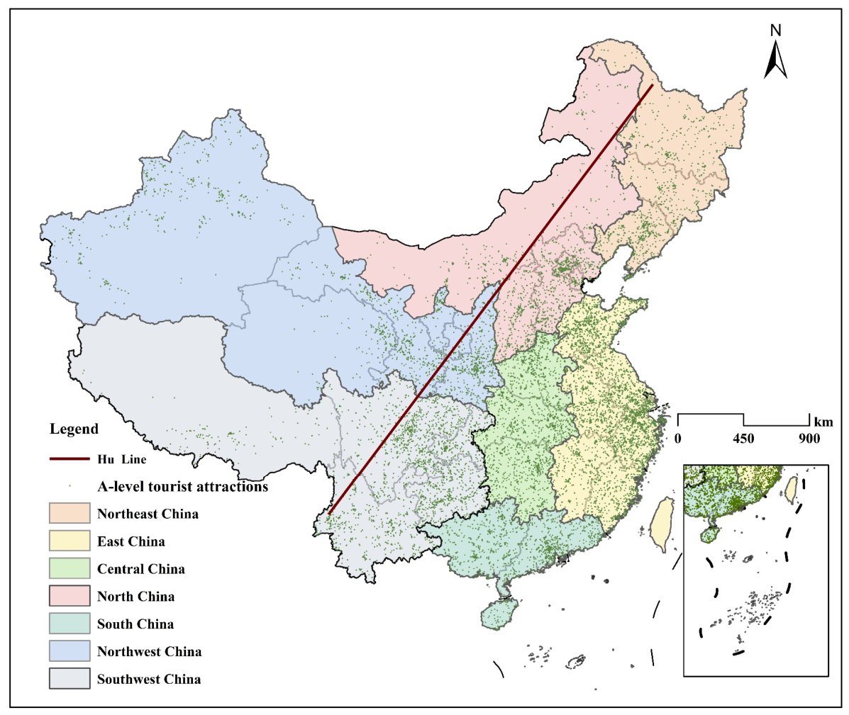
As shown in
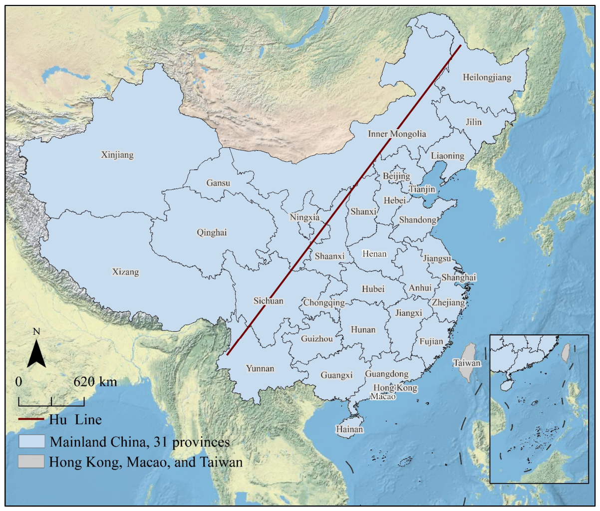
Figure 2, overall attractions exhibit a pattern of “dense in the east and sparse in the west”, revealing a significant spatial imbalance defined by the Hu Line. This line, a well-known geographic boundary separating China’s densely populated eastern regions from the sparsely populated western regions, corresponds closely to population distribution. The southeastern half, which covers 43.8% of China’s land area, hosts more than 80% of all A-level attractions, whereas the northwestern half, though accounting for 56.2% of the national territory, contains less than 20% of these attractions. This spatial distribution provides the macro-level context for analyzing hierarchical differentiation among attraction grades.
As shown in
Figure 2 and
Table 3, A-level tourist attractions are unevenly distributed across China’s seven major geographical regions. East China constitutes the core region, containing 4940 attractions, far more than any other region. Southwest China (2545 attractions) and Central China (1947 attractions) constitute the sub-core regions. North China (1676 attractions), Northwest China (1909 attractions), South China (1414 attractions), and Northeast China (1268 attractions) collectively constitute the peripheral tier. This three-tier structure empirically supports the core–periphery pattern proposed in our theoretical framework, revealing a multi-level concentration pattern in tourism spatial organization.
More importantly, pronounced hierarchical differentiation can be observed among attraction grades. Although 3A-level attractions dominate the overall system, the spatial distribution of high-grade (5A-level) and low-grade (2A-level) attractions differs substantially across regions. East China contains roughly one-third of all 5A-level attractions, whereas Northeast China contains only 19. Southwest China accommodates 53 5A-level attractions despite having fewer total attractions than East China. In contrast, 2A-level attractions are more evenly distributed across regions. The observed hierarchical differentiation highlights the coexistence of spatial concentration and quality differentiation within China’s tourism attraction system, providing a descriptive foundation for subsequent analyses of spatial sustainability and tourism development mechanisms.
3.2. Spatial Agglomeration Characteristics
Based on the nearest neighbor index, this study calculated values for overall attractions as well as for each grade level from 1A to 5A. As shown in
Table 4, China’s A-level tourist attractions exhibit a strongly clustered overall spatial agglomeration and clear hierarchical differentiation. The nearest neighbor index for overall attractions is 0.373 (
z = −150.23,
p < 0.01), indicating that the point features tend toward a clustered distribution, which is a typical agglomeration distribution pattern.
Although all attraction grades exhibit significant agglomeration (p < 0.01), the degree of agglomeration differs across grades. The nearest neighbor index values show a clear gradient: 2A-level attractions have the lowest index (0.368), followed by 3A-level (0.391), 4A-level (0.430), and 5A-level (0.548). This gradient reveals that lower-grade attractions are more spatially concentrated than higher-grade attractions, with the index increasing monotonically as attraction grade rises. This inverse relationship between attraction grade and agglomeration degree provides quantitative evidence for hierarchical differentiation in the spatial organization of China’s tourism attraction system.
3.3. Spatial Distribution Hotspots and Morphological Differences
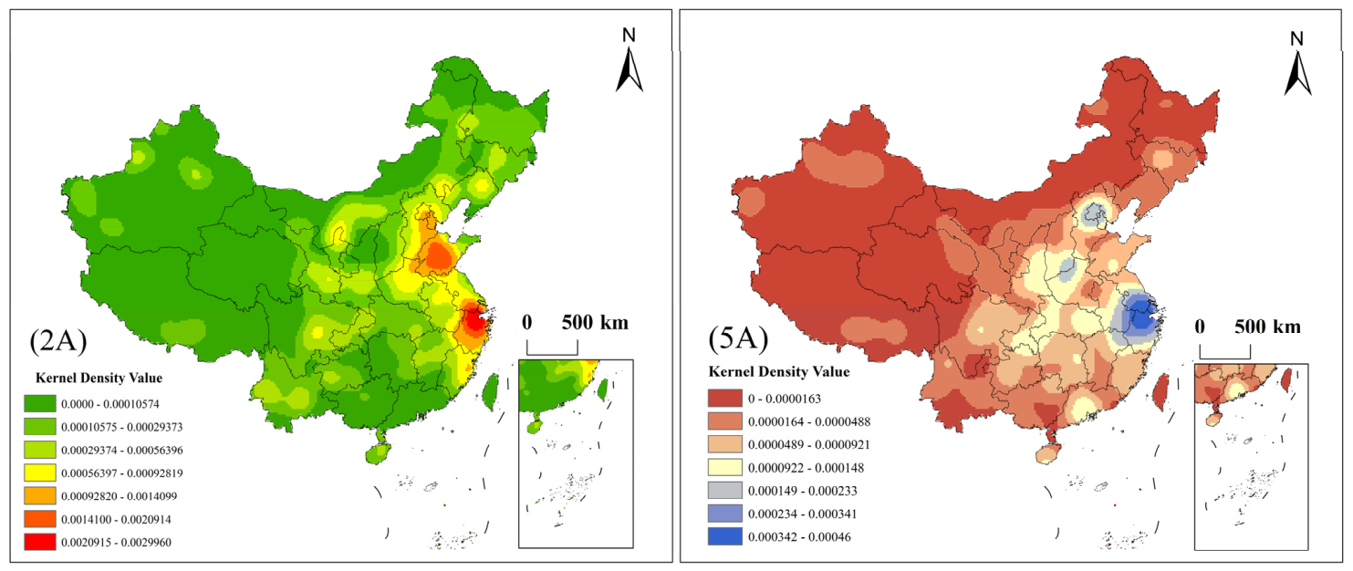
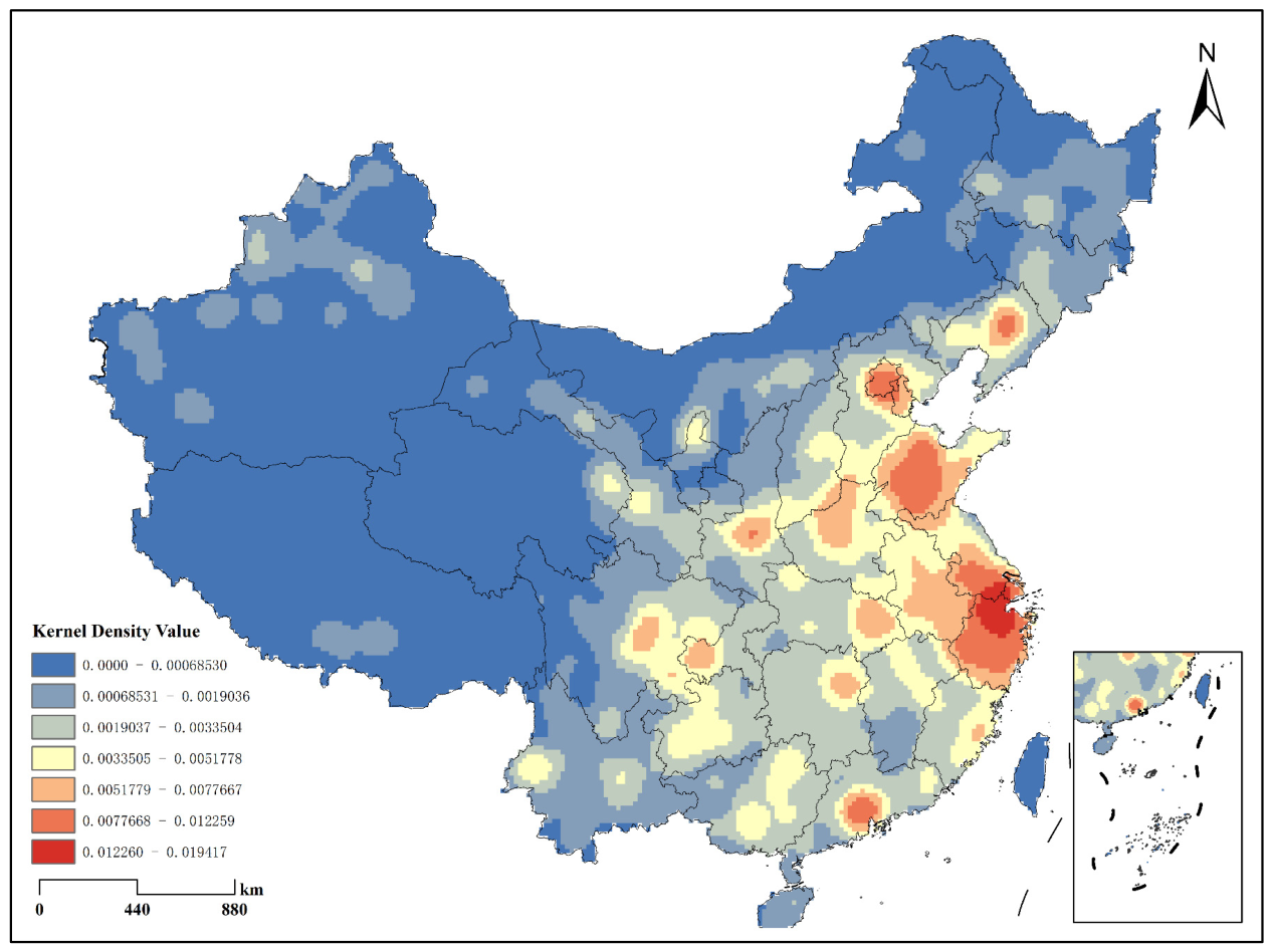
To examine hierarchical differences in spatial structure, this study performs a comparative kernel density analysis of all tourist attractions, as well as 2A- and 5A-level attractions. As shown in
Figure 3 and
Figure 4, the kernel density values for overall attractions range from 0 to 0.0194 sites/km
2, revealing a multi-core agglomeration pattern with higher density in eastern China and lower density in the west.
The high-density core areas (>0.012 sites/km2) are concentrated in the following three places. The Yangtze River Delta Urban Agglomeration, led by Shanghai and spanning southern Jiangsu and northern Zhejiang, constitutes the country’s most densely packed attraction zone, forming a continuous high-density belt. The Beijing-Tianjin-Hebei region, centred on Beijing and Tianjin, is the area with the highest concentration of attractions in northern China. The Shandong Peninsula Urban Agglomeration forms another prominent high-density area along the eastern coast. Sub-high-density areas (0.005–0.012 sites/km2) are located near major transportation hubs, including the Zhongyuan Urban Agglomeration led by Zhengzhou, the Pearl River Delta with Guangzhou and Shenzhen as its two main cities, and the Middle Reaches of the Yangtze River Urban Agglomeration centred at Wuhan and Changsha. Low-density areas (<0.001 sites/km2) are mainly distributed in Xizang (Tibet), Qinghai, southern Xinjiang, and other regions, forming continuous sparse zones.
In terms of hierarchical differences, the spatial morphology of kernel density for 2A-level and 5A-level tourist attractions exhibits significant divergence. The kernel density values for 2A-level tourist attractions range from 0 to 0.0030 sites/km2, displaying a distribution characteristic of “continuous planar distribution and suburban encirclement”. High-value areas tend to cluster on the suburban outskirts of urban agglomerations in the eastern coastal region, forming ring-shaped agglomeration belts surrounding central cities. Medium-density areas appear across much of the central and eastern provinces. In contrast, the kernel density values for 5A-level tourist attractions range from 0 to 0.00046 sites/km2, displaying a pattern of discrete and isolated hotspots. High-value areas are sporadically distributed as isolated hotspots, corresponding to locations of top-tier tourism resources such as Huangshan Mountain, Taishan Mountain, the Forbidden City, Jiuzhaigou Valley, and Zhangjiajie (selected as representative examples of top-tier 5A attractions).
In summary, attractions at different grades exhibit clear differences in spatial morphology. Compared with 5A-level attractions, 2A-level attractions display broader spatial coverage and more continuous density surfaces, whereas 5A-level attractions are characterized by isolated high-density hotspots and stronger spatial discreteness. These results further demonstrate the existence of hierarchical differentiation in the spatial organization of China’s tourism attraction system.
3.4. Spatial Association and Local Clustering Patterns
Spatial autocorrelation analysis verifies the statistical significance of spatial agglomeration. This study uses attraction density (sites/km2) as the measurement indicator to examine the spatial correlation characteristics of overall attractions at the prefecture-level city scale.
Global Moran’s I analysis (
Table 5) yields an index of 0.143 and a z-score of 31.545 (
p < 0.01), meaning that overall attractions are significantly and positively autocorrelated in space at the prefecture-level city scale. This finding confirms that the distribution of attractions is not random but rather exhibits strong spatial agglomeration. It further supports the agglomeration characteristics observed at the micro-point scale, as revealed by the nearest neighbor index (0.373).
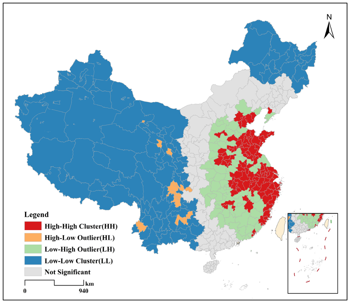
Local Moran’s I analysis further identifies specific clustering types (
Figure 5). The results are shown as follows: HH and LL clusters: HH hotspots are mainly distributed in the Yangtze River Delta Urban Agglomeration (Shanghai, Suzhou, Hangzhou, Nanjing, etc.), Beijing–Tianjin–Hebei Urban Agglomeration (Beijing, Tianjin, Baoding, etc.) and Shandong Peninsula Urban Agglomeration (Jinan, Qingdao, Yantai, etc.), which closely align with the high-value regions identified by kernel density analysis. LL cold spots appear across much of western and northern China, including most prefecture-level cities in Xizang, Qinghai, Xinjiang, and northern Heilongjiang, forming contiguous cold spot regions that reflect regional economic development levels. HL and LH outliers are sporadically distributed. The most typical HL outlier is the Chengdu–Chongqing region, which exhibits high attraction density within the core cities but low density in surrounding areas, forming an “isolated-island” high-value zone. This phenomenon highlights a key feature of tourism development in western China: single-point polarization without regional coordination. LH outliers are scattered in “depressed” cities surrounding hotspots regions, indicating local spatial heterogeneity.
These results are consistent with the findings of the nearest neighbor index and kernel density analysis, revealing a spatial pattern characterized by overall agglomeration, clustered hotspots in eastern China, and extensive low-density regions in western China. Local spatial autocorrelation further indicates that the eastern region exhibits synergistic agglomeration, whereas the western region remains dominated by single-point polarization around core cities. These patterns provide important spatial evidence for understanding hierarchical differentiation and evaluating the spatial sustainability of tourism resource allocation.
3.5. Driving Factors and Hierarchical Differentiation
3.5.1. Driving Characteristics of Overall Attractions
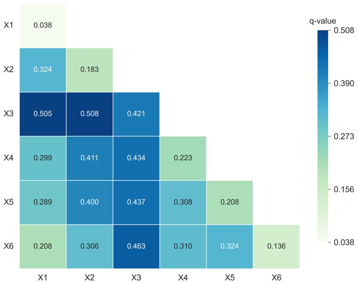
To understand the drivers behind the spatial pattern of A-level tourist attractions, this study uses the geographical detector model to quantify the individual explanatory power (q-values) of influencing factors and their interaction effects on the spatial differentiation of overall attractions. All factors passed the significance test (
p < 0.05), with q-values reported in
Figure 6 and
Figure 7.
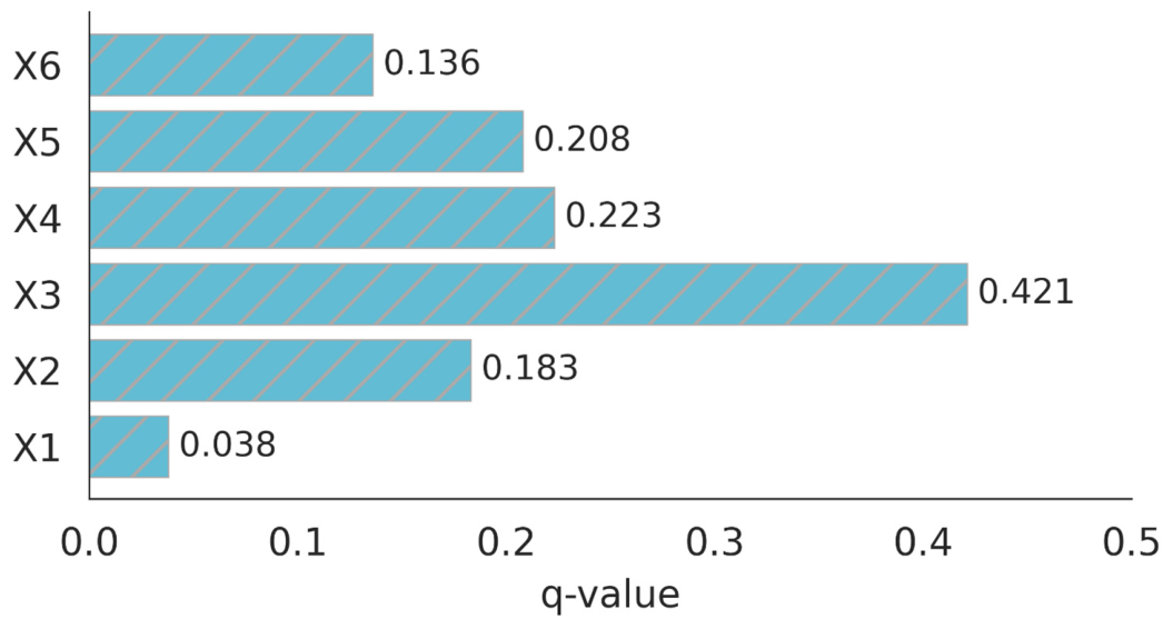
As shown in
Figure 6, the factor detection results indicate that the explanatory power of individual factors differs markedly for attraction distribution. Ranked by q-value, the factors are population density (X3, q = 0.421), highway density (X4, q = 0.223), average elevation (X5, q = 0.208), per capita GDP (X2, q = 0.183), density of national scenic areas (X6, q = 0.136), and proportion of tertiary industry (X1, q = 0.038). Population density (X3) exhibits the highest explanatory power, substantially exceeding that of the other variables. Areas with high population density largely coincide with the major attraction clusters identified in the kernel density analysis. The explanatory power of per capita GDP (X2) is relatively low compared with that of population density (X3); therefore, the spatial distribution of attractions is more closely related to population density than to economic development. The next two main factors are transport location and the natural environment. Highway density (X4) ranks second, and the average elevation (X5) ranks third, Flat, well-connected areas like the North China Plain and the Middle-Lower Yangtze Plain tend to develop dense clusters of tourist attractions. On the other hand, high-altitude areas such as the Qinghai–Tibet Plateau generally have low attraction density due to rugged terrain and limited accessibility, consistent with the western LL coldspots identified in the LISA analysis.
As shown in
Figure 7, all of the two-factor interaction terms have increased in magnitude, without any weakening or independent interaction; this indicates that the distribution of China’s A-level tourist attractions is driven by several interacting factors. Among these, population density (X3) shows the strongest synergy with the others. The interaction q-value of X2 ∩ X3 (per capita GDP ∩ population density) is 0.508, the highest among all combinations, and it can be shown that economically developed and densely populated areas generate synergistic effects enhancing attraction clustering. The Yangtze River Delta and Pearl River Delta correspond to areas where multiple high-value factors and interactions coincide.
3.5.2. Hierarchical Differentiation
2A- and 5A-level attractions exhibit markedly different driving characteristics in the single-factor detection results, highlighting pronounced hierarchical differentiation (
Table 6). For 2A-level attractions, all of the q-values of the examined factors are uniformly low, ranging from 0.017 to 0.087, and no dominant factor is identified. Population density (X3) shows the highest explanatory power among examined variables, but the values remain low relative to overall attractions. The proportion of tertiary industry (X1) is not statistically significant. In contrast, 5A-level attractions are more strongly associated with resource endowment (
X6) and thus depend on scarce natural and cultural heritage resources. The locations of nationally renowned 5A-level attractions, such as Huangshan Mountain, Mount Tai, and Jiuzhaigou, are largely determined by the spatial distribution of high-quality tourism resources. Population density (X3) and per capita GDP (X2) also exhibit relatively high explanatory power, second only to resource endowment (X6).
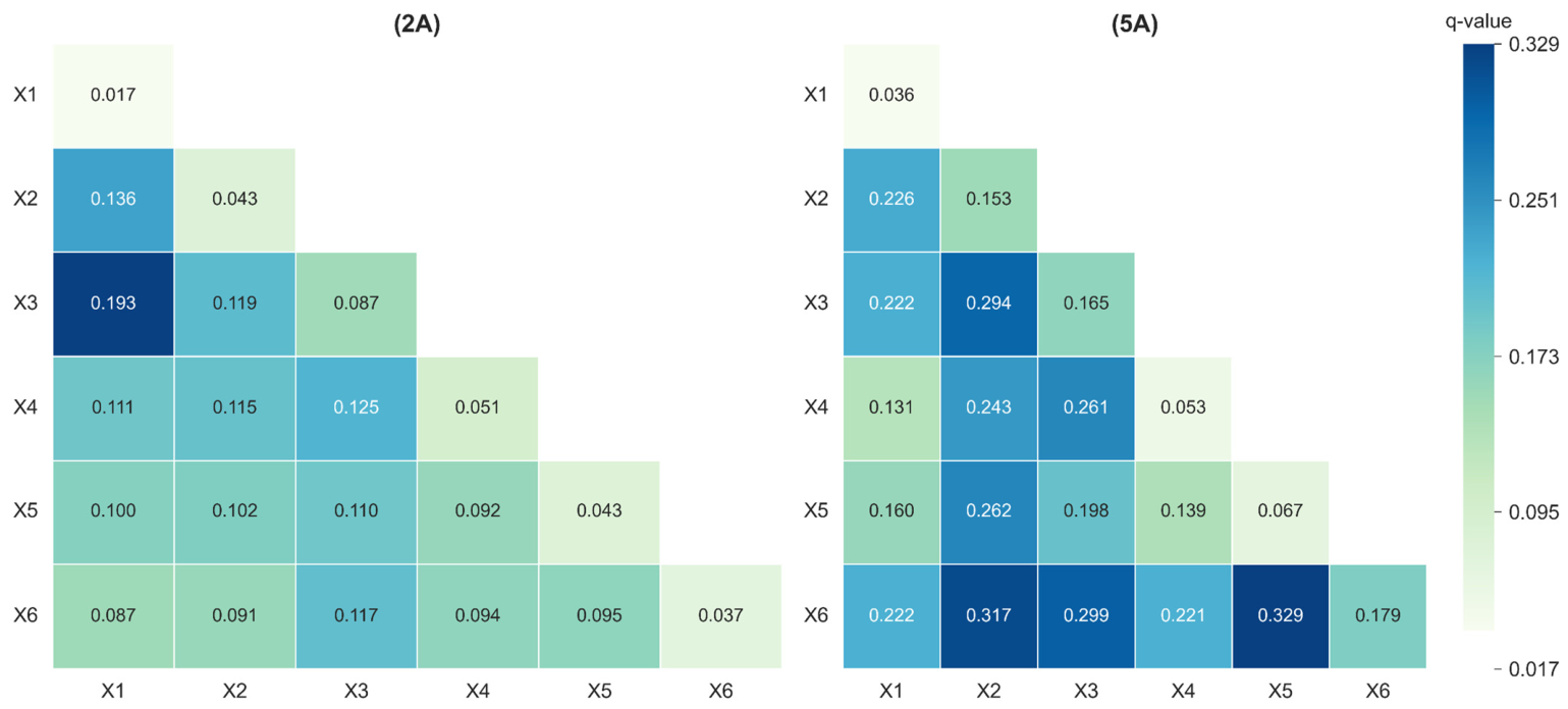
As shown in
Figure 8, the interaction synergy of 2A-level and 5A-level tourist attractions also exhibits significant hierarchical differences. The q-values of all interaction combinations for 2A-level tourist attractions remain at a relatively low level (0.087–0.193), substantially lower than those for overall attractions and 5A-level tourist attractions.
In contrast, the interaction detection of 5A-level tourist attractions demonstrates a strong enhancement effect. The three combinations with the strongest synergy are X5 ∩ X6 (average elevation ∩ density of national scenic areas, 0.329), X2 ∩ X6 (per capita GDP ∩ density of national scenic areas, 0.317), and X3 ∩ X6 (population density ∩ density of national scenic areas, 0.299). These results suggest three prominent interaction patterns for 5A-level attractions, involving resource endowment combined with terrain conditions, economic development, and population density. Overall, 2A-level attractions generally show low factor values, whereas 5A-level attractions exhibit higher explanatory power, particularly for resource endowment, population density, and per capita GDP. This pattern reflects a hierarchical spectrum of drivers from general background factors to population-related factors, and finally to resource endowment.
4. Discussion
4.1. Spatial Hierarchy of Tourist Attractions as a Reflection of Regional Development Patterns
Tourist attractions are not randomly distributed across space but deeply embedded in broader regional development processes. The results reveal a pronounced east–west disparity in the spatial distribution of China’s A-level tourist attractions, with more than 80% located southeast of the Hu Line. This pattern closely mirrors the spatial concentration of population, economic activity, and urbanization [
47], indicating that tourism development is strongly shaped by the wider geography of regional development. Unlike natural tourism resources, A-level attractions are tourism assets that have been identified, developed, managed, and formally incorporated into tourism markets through institutional certification. Their distribution therefore reflects not only the availability of tourism resources but also the capacity of regions to transform those resources into marketable tourism products, providing an important lens through which regional development conditions can be understood.
The spatial clustering patterns identified in this study are consistent with the core–periphery structure proposed by Friedmann [
48] whereby development resources and economic activities tend to concentrate in core regions and gradually diffuse outward. The Yangtze River Delta, Beijing–Tianjin–Hebei, and Shandong Peninsula urban agglomerations emerge as the principal tourism cores. In these regions, large population bases, well-developed transportation networks, and strong consumer demand interact to support the continuous expansion and upgrading of tourist attractions. The Chengdu–Chongqing region functions as a sub-core characterized by localized concentration, while the extensive LL clusters across western China remain situated at the periphery of the national tourism system.
These findings suggest that the hierarchical distribution of tourist attractions reflects broader regional development disparities rather than tourism activity alone. The observed spatial hierarchy can therefore be interpreted as a manifestation of uneven regional development, revealing the combined influence of geographical conditions and socioeconomic processes.
4.2. Hierarchical Differentiation in Tourism Development Pathways and Mechanisms
The analysis reveals pronounced hierarchical differentiation among tourist attraction grades in China. Lower-grade attractions, such as 2A-level sites, are widely distributed across urban and peri-urban areas, forming continuous clusters aligned with population centers. Their spatial organization primarily serves local leisure and everyday recreational needs, providing accessible tourism opportunities for nearby residents [
49]. In contrast, high-grade attractions, particularly 5A-level sites, exhibit selective, discrete distributions concentrated around exceptional natural or cultural resources. These attractions function as destination anchors that attract concentrated flows of regional and national tourists. The coexistence of these patterns suggests that different attraction grades perform distinct spatial roles within China’s tourism system, reflecting multiple development pathways ranging from population-oriented local tourism to resource-oriented destination development.
These spatial differences are further reflected in the driving mechanisms identified by the geographical detector model. Overall, population density exhibits the strongest explanatory power, highlighting the fundamental role of population concentration in shaping tourism space. Unlike studies in Europe and North America, where accessibility and economic development often dominate [
50], the Chinese case emphasizes the importance of population size as a fundamental condition for shaping tourism space. The underlying cause of this disparity lies in the fundamental differences between the socio-environmental and institutional contexts of China and the West. In Europe and North America, high personal mobility and a mature culture of individualized vacations allow tourist attractions to be more geographically dispersed, with their spatial layouts relying heavily on highway networks. In contrast, China’s massive population base, coupled with its high-density and rapid urbanization, has generated an unprecedented demand for localized, short-haul leisure activities. Consequently, ‘proximity to densely populated areas’ has emerged as the most critical determinant for the viability and growth of most tourist attractions in China.
The findings further indicate that the development of attractions is the result of the interaction between market demand, resource endowment, and institutional support. Resource endowment plays a particularly important role in the formation of high-grade attractions. More importantly, attractions of different grades exhibit significantly different driving structures. For 2A-level attractions, the explanatory power of individual factors is relatively weak, indicating that their distribution mainly stems from general background conditions and urban expansion processes. In contrast, the association between 5A-level attractions and resource endowment is significantly enhanced, and the interaction effects involving resources, population density, and economic development are also significantly strengthened. In addition, institutional factors, such as tourism policies, attraction evaluation standards, government investment, and regional planning, may influence both attraction upgrades and spatial distribution. However, these institutional dimensions were not included in the quantitative analysis due to data limitations.
4.3. Differentiated Strategies and Spatial Governance for Sustainable Tourism
The hierarchical distribution and spatial patterns identified in this study provide important guidance for promoting balanced and sustainable tourism development in China. The findings reveal that tourism opportunities remain markedly uneven across regions, largely driven by differences in population concentration, infrastructure provision, and regional development capacity. Achieving a more balanced tourism spatial structure requires strengthened regional coordination, particularly in peripheral areas where tourism resources are abundant yet underutilized. In western LL coldspots, tourism growth poles should be cultivated around core cities, with population agglomeration acting as a catalyst for the rational development and utilization of resources. Concurrently, continuous improvement of transportation infrastructure and tourism-related public services can enhance regional accessibility and local development capacity, helping to transform resource endowments into development advantages. By promoting stronger regional linkages, factor mobility, and resource sharing, regional disparities can be reduced, tourism development can be better balanced, and the long-term sustainability of China’s tourism spatial system can be supported.
The observed hierarchical differences further emphasize that sustainability cannot be achieved through a uniform development approach. Attractions of different grades play different roles in the tourism system, thus requiring tailored development strategies. Lower-grade attractions primarily support local leisure and community entertainment, while high-grade attractions serve as pillars of destinations, possessing stronger economic, branding, and market influence. Recognizing these functional differences is crucial for optimizing resource utilization and preventing homogenized development patterns.
Moreover, the strong interaction among population, resource endowment, economic conditions, and transportation infrastructure indicates that tourism development is shaped by a complex system of interdependent factors. Sustainable outcomes are most likely to emerge from coordinated interventions that integrate resource conservation, infrastructure enhancement, market development, and regional planning. In addition, sustainable tourism development should explicitly consider ecological and socio-cultural dimensions, including ecosystem conservation, cultural heritage preservation, community engagement, and tourism resilience, to ensure long-term balanced growth and resilience.
5. Conclusions
5.1. Main Conclusions
Using the 2024 POI data for China’s A-level tourist attractions, this study discusses the hierarchical differentiation and multi-grade driving factors associated with this pattern, thereby providing a scientific basis for understanding spatial differentiation and sustainable governance in the context of regional development. The main conclusions are as follows:
A-level tourist attractions in China exhibit an unbalanced pattern of “dense in the east and sparse in the west”, with the Hu Line serving as a long-term structural boundary. This indicates that tourism development is fundamentally constrained by regional development gradients rather than random spatial processes.
The spatial organization of tourist attractions shows a clear multi-level hierarchy, forming a stable core–sub-core–periphery system. Eastern coastal urban agglomerations function as dominant cores, while western regions remain peripheral with fragmented and polarized development patterns, reflecting persistent regional disparities in tourism development.
Driving factors exhibit significant grade-dependent heterogeneity. Overall attraction distribution is population-driven, indicating the dominant role of market demand. Lower-grade attractions show weak dependence on specific factors, whereas higher-grade attractions are primarily constrained by resource endowment and multi-factor synergy, demonstrating an evolutionary shift from accessibility-driven clustering to resource-constrained agglomeration.
5.2. Limitations and Future Research
Despite the contributions of this study, several limitations should be acknowledged. First, because of the application of cross-sectional data, only a static spatial distribution is observed, and changes over time and dynamic alterations in the underlying reasons are not presented. Second, although POI data provide extensive coverage, potential biases due to geocoding errors, update delays, and classification inconsistencies may introduce spatial inaccuracies. Third, explanatory variables are mainly geographical and socioeconomic indicators; institutional and policy factors, such as tourism development plans and government investment, were not included due to data constraints. Finally, potential spatial autocorrelation among explanatory variables could affect the interpretation of factor interactions.
Future research could address these limitations by incorporating longitudinal datasets to trace the spatiotemporal evolution of tourist attraction systems and their driving mechanisms. The integration of multi-source geographic, socioeconomic, and institutional data would further improve the explanatory framework. In addition, the application of spatial econometric approaches could provide a more rigorous assessment of spatial dependence and interaction effects, thereby contributing to a deeper understanding of tourism spatial organization and supporting evidence-based tourism planning and governance.