Article

Multi-Scale Ecological Coupling Mechanisms of Environment, Pattern, and Architecture in Traditional Villages of Southern Shaanxi

School of Art and Design, Shaanxi University of Science & Technology, Xi’an 710021, China
*
Author to whom correspondence should be addressed.
Sustainability 2026, 18(11), 5405; https://doi.org/10.3390/su18115405
Submission received: 10 April 2026 / Revised: 7 May 2026 / Accepted: 21 May 2026 / Published: 27 May 2026

Abstract

Traditional villages represent vital living heritage in China. We develop a multi-scale eco-coupling framework integrating GIS spatial analysis and 3D laser scanning to analyze the natural and social environment, spatial patterns, and architectural forms across macro–meso–micro levels in traditional villages of southern Shaanxi, and use partial least squares structural equation modeling (PLS-SEM) to test the hypothesized cross-scale pathways. The results show significant spatial clustering, mainly in the water-adjacent low-mountain valleys and under moderate gradients of GDP, population density, and road density. The morphology is classified as clustered, linear, or scatter shaped, while buildings are dominated by courtyard, patio, and single-row layouts with timber structures, rammed earth or stone walls, and double-pitched roofs. After reliability and validity checks, the PLS-SEM confirms significant macro–meso–micro pathways, with the meso scale as a key mediator. Overall, the study reveals that persistence depends on long-term coupling among multi-scale factors, providing theoretical and methodological support for conservation and sustainable development.

1. Introduction

Traditional villages are important conservers of China’s agrarian civilization [1,2]. They preserve historical spatial structures, local construction traditions, and cultural memory. However, rapid urbanization has intensified regional development imbalances and has placed increasing pressure on many traditional villages, threatening their survival [3,4]. Since the 1990s, resource depletion and sustained population outmigration have accelerated village decline, while successful cases of endogenous and sustainable revitalization remain limited [5]. In response, the Chinese government has established national conservation programs to coordinate heritage protection, rural development, and modernization [6,7].
With the parallel advancement of cultural heritage protection and rural revitalization strategies, traditional villages have attracted sustained attention across multiple academic disciplines. Recent studies in sociology [3,8,9,10], geography [11,12,13,14], anthropology [15,16,17], and ecology [18,19,20,21] have progressively expanded the research scope to encompass village spatial organization, architectural form characteristics, sociocultural system dynamics, and their interactions with their ecological environments. For example, Wang et al. [11] examined the spatial distribution mechanisms of and influencing factors on traditional villages in the Jiangnan region and proposed corresponding strategies for sustainable development. Huang et al. [14] used GIS to analyze 204 ancient settlement points in the Nanxi River Basin, revealing their spatiotemporal evolution and the important role of intangible cultural heritage. Zhou et al. [22] proposed an automated approach to 3D modeling of traditional village architectural heritage in Jiangnan using deep learning and remote sensing imagery, aiming to achieve efficient and low-cost digital heritage conservation. Wang et al. [19] investigated the evolution and driving mechanisms of ecological–production–living spatial carrying capacity in tourism-oriented traditional villages, offering practical implications for sustainable tourism development. Tang et al. [23] examined the cultural transmission capacity of 16 tourism-oriented traditional villages in Beijing by constructing an evaluation index system and identifying four pathways for enhancing cultural heritage transmission. Recent methodological developments have moved traditional village research beyond literature reviews [24,25,26] and field investigations [27,28] toward data-driven and multidimensional analyses [29,30,31]. At the same time, research perspectives have shifted from isolated macro- or micro-scale studies to integrated multi-scale frameworks covering macro, meso, and micro levels [32,33]. This transition has provided a stronger basis for understanding traditional village systems and for supporting heritage conservation and rural revitalization.
As critical spatial units embodying regional historical memory and cultural identity, traditional villages reflect the evolution of human–environment relationships and represent concentrated expressions of regional social structures and ecological wisdom [7,34]. The current research on traditional villages is dominated by Geographic Information System (GIS)-based spatial analysis, with techniques such as kernel density estimation, Moran’s I, and geographical detectors being widely applied to quantify spatial patterns and identify the driving mechanisms [1,27,35,36]. Moreover, advances in digital surveying technologies have expanded architectural heritage research through the application of three-dimensional laser scanning, oblique photogrammetry, and BIM modeling, enabling fine-grained documentation of architectural morphology and systematic identification of regional characteristics [9,10,37,38,39]. In addition, multi-criteria decision-making approaches, including analytic hierarchy processes and entropy weight methods, along with system dynamics models, have been employed to evaluate the coupling relationships among village conservation, resource utilization, and tourism development [28,40,41,42,43]. Despite these methodological advances, the existing studies remain largely confined to single dimensions and lack integrated multi-scale perspectives across macro, meso, and micro levels, limiting systematic examination of the coupled interactions among the spatial, architectural, ecological, and social dimensions. Moreover, quantitative modeling and qualitative interpretation are still insufficiently integrated. This limitation has prevented the formation of a coherent analytical framework for explaining how spatial, architectural, ecological, and social factors interact across scales. A more integrated framework is therefore needed to connect empirical analysis with conservation practice.
Recent studies have increasingly shifted from broad spatial analysis to more detailed investigations of village morphology and architectural heritage [44,45]. Architectural heritage is the material foundation of village continuity. It records the spatial form, construction knowledge, cultural texture, and social memory. Nevertheless, the relationship between village-scale spatial organization and building-scale heritage characteristics remains insufficiently examined. The existing studies have also tended to focus on specific administrative areas or on regions in southwestern, central, and eastern China [6,46,47], while traditional villages in northwest China have received less attention. Southern Shaanxi therefore provides a meaningful case for examining traditional village conservation and architectural heritage renewal in a transitional geographical region [48,49].
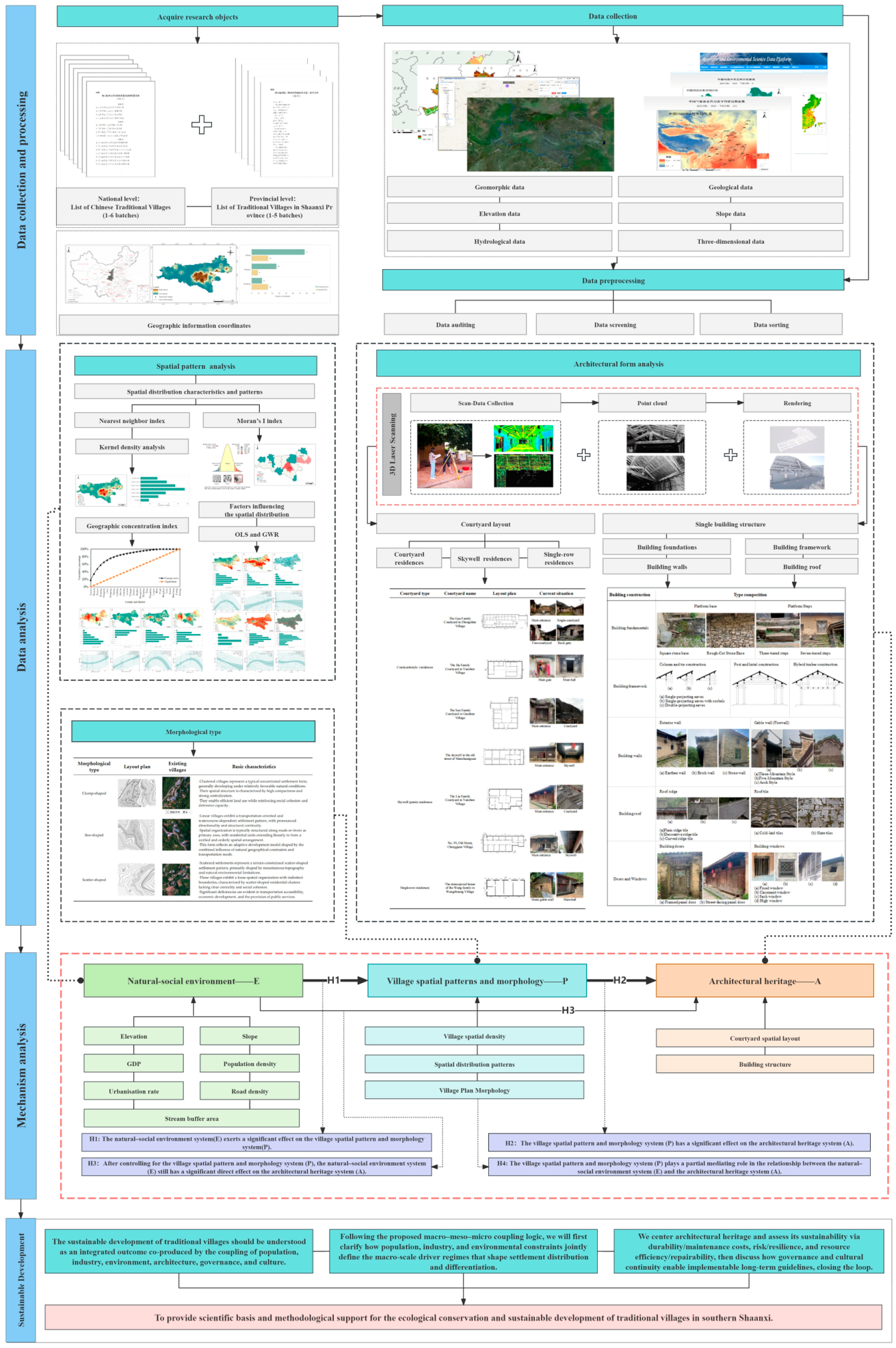
This study takes southern Shaanxi as the research area. The region is an important demonstration zone for rural revitalization in Shaanxi Province and has made continuous progress in the protection and development of traditional villages [50]. However, compared with the Guanzhong Plain and the Loess Plateau of northern Shaanxi, systematic research on traditional villages in southern Shaanxi remains limited, especially in relation to spatial organization, architectural typologies, and construction techniques [51]. At the same time, rapid urban development has intensified the decline of architectural heritage, and increased village hollowing and the loss of traditional construction skills. To address these issues, this study develops a multi-scale eco-coupling framework to examine spatial patterns, village morphology, and architectural forms across macro, meso, and micro levels. PLS-SEM is further used to test the cross-scale linkage pathways among environment, village pattern, and architectural heritage (Figure 1).

2. Materials and Methods

2.1. Research Materials

Southern Shaanxi is located in the southern part of Shaanxi Province. It includes Hanzhong, Ankang, and Shangluo, covering 28 districts and counties with a total area of approximately 69,500 km2 [52]. The region is dominated by the Qinba mountainous terrain. The Qinling Mountains form its northern boundary and separate it from the Guanzhong Plain, while the Bashan Mountains connect it with the Chu–Shu region to the south [53]. Southern Shaanxi also forms an important watershed between the Yellow River Basin and the Yangtze River Basin. Climatically, it lies in the subtropical zone and is characterized by distinct seasons, a mild and humid climate, abundant precipitation, and favorable ecological conditions [54] (Figure 2).

2.2. Data Sources

The village dataset is based on the six batches of the National List of Traditional Villages released since 2012 by the Ministry of Housing and Urban–Rural Development and other national departments. The list includes 8155 traditional villages nationwide, of which 57 are located in southern Shaanxi. In addition, Shaanxi Province has released four batches of provincial-level traditional villages since 2015, with 484 villages in total. Among them, 128 are located in southern Shaanxi, ranking first in the province. The geographic coordinates of each traditional village were extracted from Google Earth and then vectorized in ArcGIS 10.8 for data preprocessing. The digital elevation model (DEM) data for traditional villages in southern Shaanxi were obtained from the SRTM database, while additional geographic data were sourced from the National Geomatics Center of China (https://www.tianditu.gov.cn/, accessed on 20 August 2024), the Geo-Information (GIS) and Remote Sensing (RS) platform (https://www.gisrs.cn/, accessed on 1 January 2012), and the Resource and Environment Data Center of the Chinese Academy of Sciences (https://www.resdc.cn/, accessed on 20 August 2024). The socioeconomic and demographic data were primarily obtained from the China Statistical Yearbook (https://www.stats.gov.cn/sj/ndsj/, accessed on 1 January 2026) and Shaanxi Statistical Yearbook (http://tjj.shaanxi.gov.cn/tjsj/ndsj/tjnj/, accessed on 1 January 2026).
It should be clarified that the sample used in this study represents officially recognized traditional villages rather than all rural settlements in southern Shaanxi. The use of national- and provincial-level lists ensures data comparability and policy relevance, but it may also introduce a list-based selection bias. Villages that have not yet been included in official lists, especially localized and peripheral settlements with fragmentary architectural remains, local construction practices, or living heritage value, are not fully covered by the present dataset. Therefore, the spatial patterns identified in this study should be interpreted as the distribution pattern of recognized traditional village heritage resources, rather than as a complete representation of all heritage-related rural settlements in southern Shaanxi. In addition, the socioeconomic variables used in this study are mainly employed to characterize the current regional context of officially recognized traditional villages. Although statistical yearbooks provide the possibility of constructing multi-year datasets, the present study does not establish a full longitudinal time-series model. Therefore, the socioeconomic indicators should be interpreted as cross-sectional explanatory variables for identifying regional associations, rather than as evidence of long-term dynamic causality.

2.3. Research Framework

This study focuses on traditional villages in southern Shaanxi and develops a multi-scale eco-coupling analytical framework based on a macro–meso–micro hierarchy (Figure 3). The framework follows a progressive logic of spatial identification, morphological interpretation, architectural evidence extraction, and mechanism validation. At the macro scale, the natural–socioeconomic environment is examined using GIS-based spatial analysis. Village coordinates extracted from Google Earth are processed in ArcGIS to identify spatial distribution patterns, clustering characteristics, and environmental associations. At the meso scale, village spatial patterns and morphologies are analyzed through typological classification and field-based interpretation, with attention to the relationship between settlement form, road–river corridors, terrain constraints, and functional organization. At the micro scale, architectural heritage is documented through field surveys and 3D laser scanning, focusing on courtyard layout, building structure, material use, and construction details.
These three levels correspond to the three latent systems in the proposed E–P–A model: environment (E), village spatial pattern and morphology (P), and architectural heritage (A). On this basis, PLS-SEM is introduced not as an additional descriptive method, but as a validation tool for testing whether the macro-scale environment influences the architectural heritage directly and indirectly through the meso-scale village morphology. This framework therefore links qualitative architectural interpretation with quantitative path testing and provides a coherent analytical chain for explaining the ecological coupling mechanism of traditional villages.
From an ecological coupling perspective, the sustainable development of traditional villages is primarily influenced by three key factors: the natural–socioeconomic environment (E), village spatial pattern and morphology (P), and architectural heritage (A). These correspond to the three latent variables in the structural model. Since these latent variables cannot be directly observed, this study references the existing “Evaluation Index System for China’s Historical and Cultural Towns (Villages),” the “Evaluation and Recognition Index System for Traditional Villages (Trial),” and indicator systems developed in prior research for traditional village conservation and development. Considering the practical constraints of data collection from field surveys, the measurement indicators for this study are defined (Table 1). To validate the aforementioned E-P-A coupling mechanism at the quantitative level, this study constructs a structural equation model based on the preceding analysis and indicator systems, and proposes the following research hypotheses:
H1: 
The natural–social environment system (E) exerts a significant effect on the village spatial pattern and morphology system (P).
H2: 
The village spatial pattern and morphology system (P) has a significant effect on the architectural heritage system (A).
H3: 
After controlling for the village spatial pattern and morphology system (P), the natural–social environment system (E) still has a significant direct effect on the architectural heritage system (A).
H4: 
The village spatial pattern and morphology system (P) plays a partial mediating role in the relationship between the natural–social environment system (E) and the architectural heritage system (A).

2.4. Research Method

To avoid treating the methods as separate procedures, this study organizes them according to the macro–meso–micro analytical framework. GIS-based methods, including kernel density estimation, geographic concentration index, spatial autocorrelation, OLS, and GWR, are used collectively to identify the macro-scale spatial patterns and environmental–socioeconomic associations. Field investigation, typological classification, and 3D laser scanning are used to interpret the meso-scale settlement morphology and micro-scale architectural heritage characteristics. PLS-SEM is then used to integrate these observed variables into a path model and test the hypothesized E–P–A coupling mechanism. Therefore, the methodological design follows a sequential logic from spatial description to driver interpretation and finally to mechanism validation.

2.4.1. Kernel Density Analysis

Kernel density estimation (KDE) is employed to characterize the spatial distribution density of traditional villages in southern Shaanxi. By treating each village location as a probabilistic contribution and aggregating these contributions across space, KDE enables the quantification of spatial clustering through the construction of a continuous probability density surface [55]. In this approach, the estimation location x and the bandwidth (h) represent the key parameters governing the smoothing process and directly influence the resulting density pattern. The kernel density function is expressed as follows:
f x = 1 nh i = 1 n k d i n
d i = x x i
where f x denotes the kernel density estimate at a given point within the study area; n represents the total number of observations; h is the search radius (bandwidth) and h   >   0 ; and d i is the absolute distance between the estimation point and the sample point. Through iterative computation, an appropriate bandwidth is determined, and the kernel density distribution map of traditional villages in southern Shaanxi is subsequently generated.

2.4.2. Geographic Concentration Index

The geographic concentration index is employed to assess the degree of spatial concentration of traditional villages across counties [56]. The calculation formula is expressed as follows:
G = 100 × i = 1 n X i T 2
where G represents the geographic concentration index of traditional villages; n denotes the total number of counties; X i is the number of traditional villages in county i; and T denotes the total number of traditional villages. The value of G ranges from 0 to 100, with higher values indicating a more concentrated spatial distribution and lower values indicating a more scatter-shaped pattern.

2.4.3. Spatial Autocorrelation Analysis

The degree of spatial association of traditional villages within the study area is assessed using a spatial autocorrelation analysis. A global spatial autocorrelation reflects whether the spatial distribution of a given phenomenon exhibits significant clustering or dispersion across an entire region [11]. In this study, the global Moran’s I index is employed to evaluate the overall spatial autocorrelation of traditional villages in southern Shaanxi and measure the degree of similarity among spatially adjacent units. When I > 0, the spatial distribution is characterized by clustering; when I≈0, the distribution approximates randomness; and when I < 0, the distribution is scatter-shaped. The global Moran’s I is calculated as follows:
I = N i = 1 N j = 1 N w ij · i = 1 N j = 1 N w ij x i x x j x i = 1 N x i x 2
To further identify the areas exhibiting high clustering, low clustering, and spatial outliers, a local Moran’s I analysis is conducted based on the results of global Moran’s I. The local spatial patterns are classified into four cluster types: high–high (H–H), high–low (H–L), low–high (L–H), and low–low (L–L). The local Moran’s I is expressed as follows:
I i = x i x s 2 j i N w ij x j x
s 2 = j = 1 n x j x 2 n 1
where N denotes the total number of counties within the study area; w ij represents the spatial adjacency relationship between counties i and j (where w ij = 1 if the two counties are adjacent, and w ij = 0 otherwise); x i and x j denote the number of traditional villages in counties i and j; and x is the mean number of traditional villages within the study area.

2.4.4. OLS and GWR

An ordinary least squares (OLS) regression is applied to examine the global relationships between the spatial distribution of traditional villages and their influencing factors. Subsequently, a Geographically Weighted Regression (GWR) is employed to extend the OLS framework by capturing the spatial variations in these relationships across different locations. By performing locally weighted regressions at each geographic location, the GWR generates a set of local regression coefficients (LRCs) that can be spatially visualized to reveal the underlying spatial heterogeneity [44]. The combined application of OLS and GWR enables a multilevel analytical perspective that bridges the overarching global trends and fine-scale local characteristics. The OLS model is expressed as follows:
y i = β 0 + k = 1 p β k x ik + ε i
where y i denotes the density of traditional villages (dependent variable); and x ik represents the k (k = 1,2,…,n) influencing factor of sample i, such as elevation, slope, GDP, or population density (independent variables); β 0 is the intercept term (constant); β k is the regression coefficient corresponding to the k independent variable (constant in the global OLS model); and ε i is the random error term.
y i = β 0 u i , v i + k = 1 p β k u i , v i x ik + ε i
where ( u i , v i ) represents the geographic coordinates of sample point i ; and β k denotes the local regression coefficient at location ( u i , v i ), which varies spatially. All remaining symbols retain the same meaning as defined in the OLS model.

2.4.5. Structural Equation Modeling

Traditional villages constitute complex systems shaped by multiple latent variables that are not directly observable and therefore must be represented by directly measurable manifest indicators. To investigate the causal relationships among influencing factors, this study employs partial least squares structural equation modeling (PLS-SEM), within which both the measurement model and the structural model are specified in a unified framework to identify the latent constructs and their effect pathways. This approach helps elucidate the underlying mechanisms governing traditional village development and provides methodological support for promoting sustainability in traditional villages. The specific equations are as follows:
Y = Λ y η + ε
X = Λ x ξ + δ
where Equations (9) and (10) correspond to the exogenous and endogenous measurement models, respectively. Here, Λ x   denotes the factor loading matrix linking the observed exogenous indicators to the exogenous latent construct ξ , and Λ y   denotes the factor loading matrix linking the observed endogenous indicators to the endogenous latent construct η . The terms δ and ε represent the measurement error vectors of the respective measurement models. The structural model specifies the causal relationships between the endogenous and exogenous latent constructs. The specific equations are as follows:
η j = k β j k η k + m γ j m ξ m + ζ j
where η j denotes the endogenous latent variable, η k denotes other endogenous latent variables included as predictors, and β j k is the structural path coefficient between the endogenous constructs. ξ m denotes the exogenous latent variable, γ j m is the path coefficient, and ζ j is the residual term.

3. Results

3.1. Spatial Distribution Patterns of Traditional Villages in Southern Shaanxi

3.1.1. Spatial Distribution Characteristics and Patterns

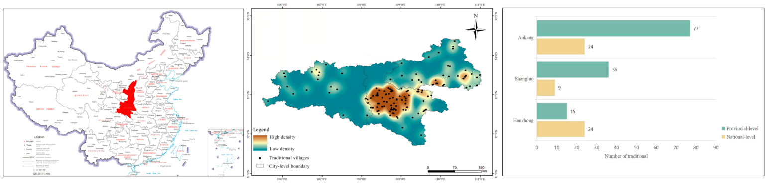
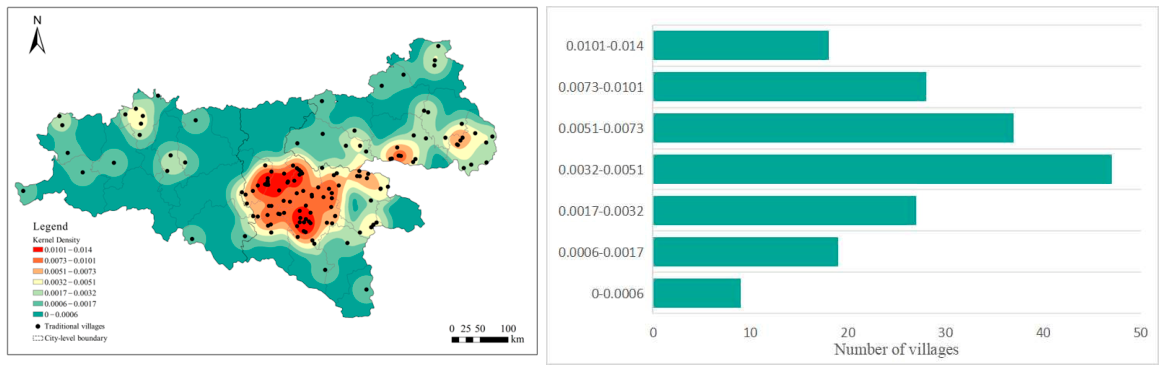
ArcGIS was used to visualize and analyze the spatial distribution of traditional villages in southern Shaanxi. The kernel density analysis showed that the villages are mainly concentrated in Ankang City, forming distinct high-density clusters, with the density decreasing eastward and westward to produce a pattern of “central concentration and east–west dispersion”. The primary high-density area occurs in central Ankang (Hanbin District, Shiquan County, and Hanyin County), with kernel density values of 0.010–0.014, while secondary clusters appear in southern Shangluo (Shanyang and Shangnan counties), with values of 0.0073–0.010. In contrast, villages are relatively sparse in Hanzhong, the northern and southern parts of Ankang, and northern Shangluo (0.0006–0.0051) (Figure 4). The ANN value is <1, indicating an overall clustered distribution with significant variations existing in spatial density.

3.1.2. Degree of Spatial Distribution Equity

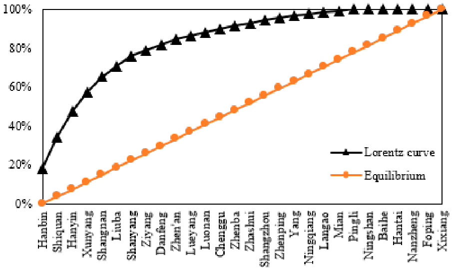
The degree of spatial distribution equity in the traditional villages was quantified using the imbalance index. The calculated imbalance index for southern Shaanxi was S = 0.723, which approached 1. This indicated a markedly uneven spatial distribution. The geographic concentration index further reflected the degree of clustering in the spatial distribution of traditional villages. The computed value for southern Shaanxi was G = 32.064, which was substantially higher than the regional average value of G0 = 7.14. This demonstrates a relatively high level of spatial concentration. The most densely clustered traditional villages are located in Hanbin District, followed by Shiquan County and Hanyin County (Figure 5).

3.1.3. Significant Spatial Autocorrelation

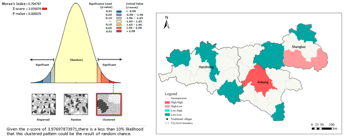
The spatial autocorrelation at both the global and local levels was examined using Moran’s I for traditional villages in southern Shaanxi. The results indicate a significant positive global spatial autocorrelation (p < 0.01; z = 3.98 > 2.58), demonstrating an overall clustered spatial distribution pattern, with Moran’s I = 0.70 (>0). The local spatial autocorrelation analysis reveals that among the 28 counties, four exhibited strong spatial clustering. Ankang City and Hanyin County were classified as H–H clusters, whereas Shanyang County and Shangnan County were identified as H–L clusters. In addition, eight counties displayed L–L clustering, including Lueyang, Liuba, Chenggu, and Zhenba in Hanzhong; Zhenping in Ankang; and Zhen’an, Zhashui, and Luonan in Shangluo (Figure 6).
However, low density in the listed village dataset should not be equated with the absence of rural heritage value. Some peripheral areas may contain unlisted villages with localized architectural features, dispersed heritage remains, or living construction traditions that require further field verification.

3.2. Factors Influencing the Spatial Distribution of Traditional Villages in Southern Shaanxi

3.2.1. Natural Environmental Factors

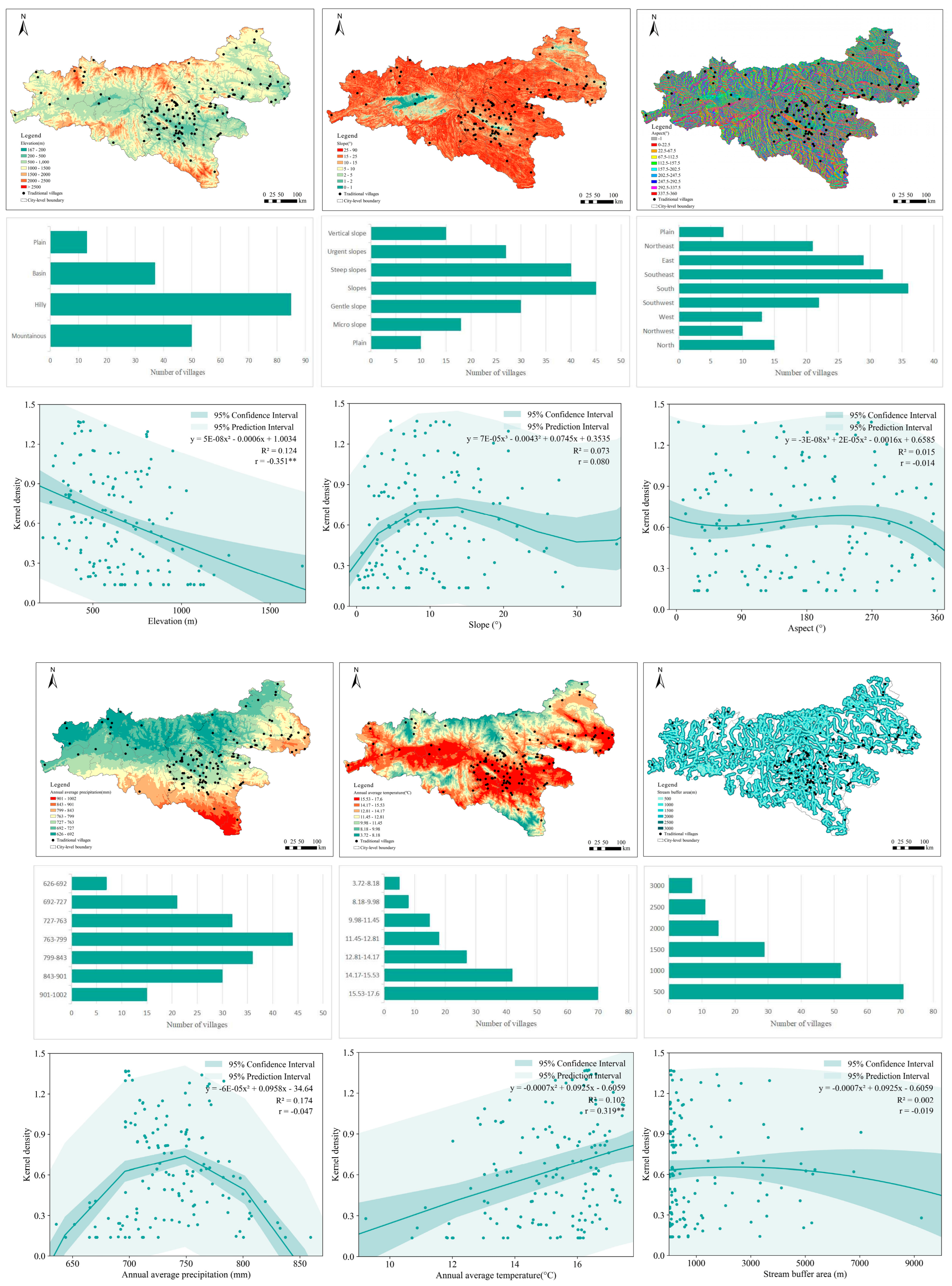
Natural environmental factors constitute the fundamental conditions shaping the formation and persistence of traditional village spatial patterns and exert a strong influence on village economic structures, architectural characteristics, and cultural landscapes [4]. Their effects are reflected in the following aspects (Figure 7).
(1)
Geographical factors
The elevation, slope, and aspect jointly regulate village site selection at different spatial scales. Traditional villages in southern Shaanxi have a clear preference for low-elevation environments, being predominantly distributed in valleys, basins, and hilly areas below 1000 m. The highest concentration occurs between 200 and 800 m, accounting for approximately 71.3% of all villages. In terms of slope conditions, the average slope of village sites is 11°, and approximately 95.2% of villages are located on slopes within the range of 0.5–35°. Pronounced clustering is observed within the gentle slope interval of 5–20°.
(2)
Climatic and hydrological factors
Traditional villages in southern Shaanxi are mainly distributed in areas characterized by distinct seasons, with mild and humid climates, moderate precipitation, and abundant water resources [57]. Approximately 81.6% of villages are located in zones with an annual mean temperature of 15–17 °C and annual precipitation of 700–800 mm. Spatially, villages are predominantly situated within river buffer zones. Specifically, 78.3% of traditional villages lay within 0–1 km of a water source, with the highest proportion (51.6%) concentrated within 0–0.5 km, followed by 26.7% within 0.5–1 km. Only 7.6% of villages are located more than 2.5 km from a water source. Overall, traditional villages exhibit an evident water-oriented settlement pattern, reflecting not only the requirements of domestic water use and agricultural irrigation but also the historical role of rivers as transportation corridors.

3.2.2. Socioeconomic Factors

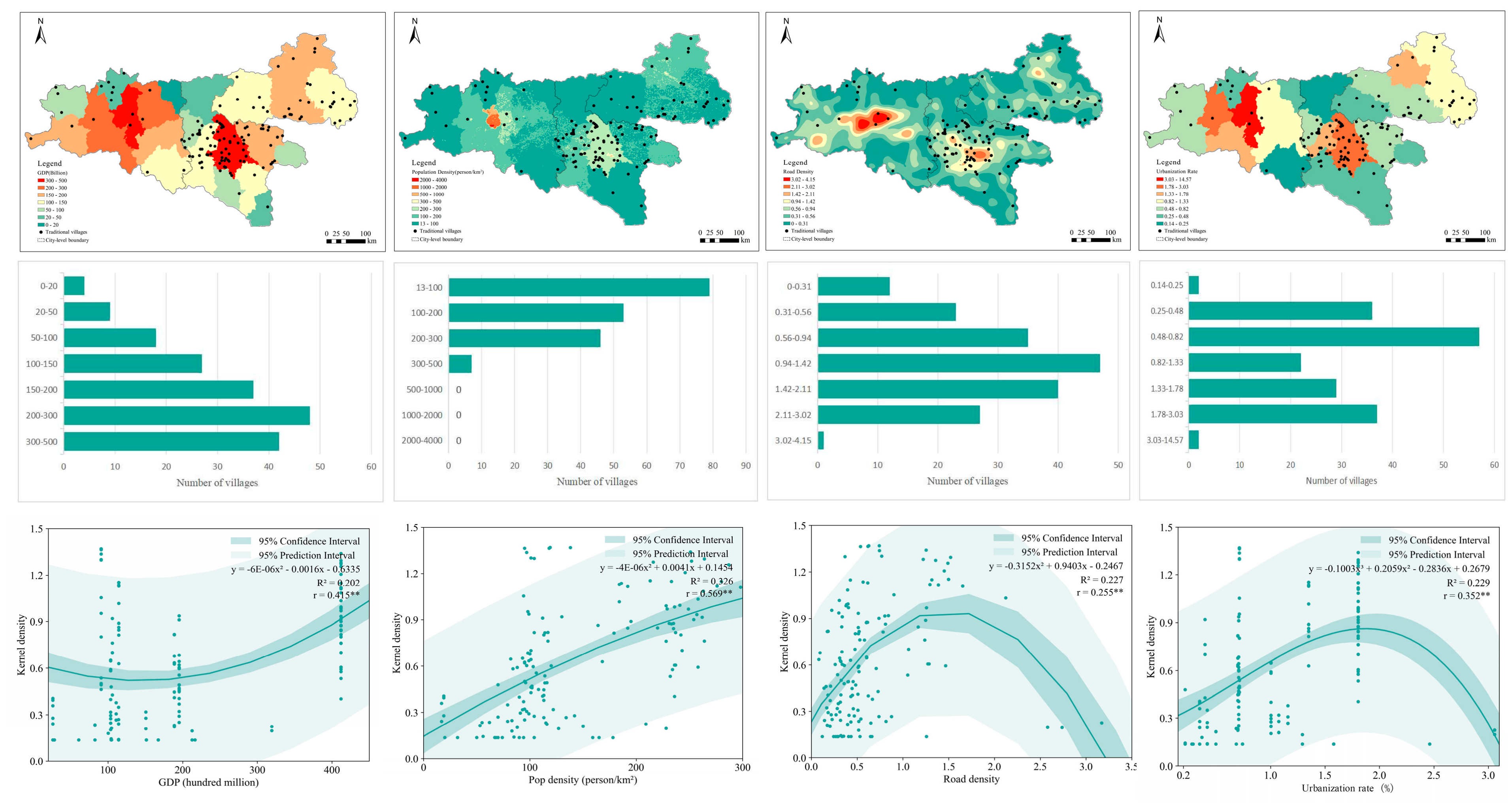
Socioeconomic factors play a bridging role in shaping the spatial distribution patterns of traditional villages. In southern Shaanxi, the GDP level, population density, transportation conditions, and urbanization intensity are significantly associated with village distribution (Figure 8).
(1)
GDP: Traditional villages are predominantly distributed in areas with GDP values of 5–20 billion CNY, accounting for 79.2% of all villages. Within this interval, the village density shows a negative relationship with the GDP (a higher GDP corresponds to lower village density). In contrast, the village density increases sharply in areas with GDP of 30–50 billion CNY, mainly concentrated in Ankang City.
(2)
Population density: Traditional villages are mainly located in areas with population densities <500 persons/km2, with 96.2% falling within the range of 50–250 persons/km2. Village numbers are relatively low in both very high-density zones (>2000 persons/km2) and very low-density zones (<50 persons/km2), forming an inverted U-shaped distribution pattern.
(3)
Road density: The road density is generally higher in central areas and lower toward the periphery. Village distribution exhibits a pronounced nonlinear relationship with road density, with most villages located within 0.56–2.11 km/km2 of roads.
(4)
Urbanization: Areas with low urbanization rates contain relatively large numbers of villages; the highest concentration of villages occurs within the moderate urbanization range of 0.8–1.8%. Village numbers decline sharply at higher urbanization levels (>2.0%).

3.3. Morphological Classification of Traditional Villages in Southern Shaanxi

The traditional villages in southern Shaanxi exhibit pronounced morphological diversity and strong regional adaptability. The settlement forms can be classified into three primary types—clustered, linear, and scatter shaped. Despite these differences, their spatial structures share several fundamental components: road–alley systems that organize circulation, public spaces for social interaction and collective activities, production spaces linked to agricultural practices, religious and ritual spaces that reinforce clan cohesion and local belief systems, and dwelling spaces centered on courtyard-based residential units (Table 2).
The differentiation among these settlement types arises primarily from variations in the configuration and relative dominance of these fundamental spatial units [58]. Clustered villages feature concentrated residential and religious spaces, forming compact patterns under relatively favorable natural conditions. Linear villages typically develop along major transport routes or river corridors, unfolding longitudinally with strong directionality and continuity. Scatter-shaped villages comprise relatively independent spatial units distributed across the landscape, reflecting constraints imposed by mountainous topography and environmental conditions. Overall, these forms and spatial structures reflect adaptive strategies and diversified development patterns in response to complex terrain, as well as human–environment interactions and the spatial expression of regional cultural traditions.
By overlaying the OLS and GWR driver regimes with the mapped village morphology types, we observe a clear spatial correspondence between the local driver effects and morphology differentiation. Clump-shaped villages are more frequently distributed in areas characterized by weaker topographic constraints and stronger positive local coefficients for road density, suggesting that compact settlement forms tend to co-occur with relatively favorable buildability and higher accessibility contexts. Line-shaped villages are concentrated in zones where the hydrological factor exhibits a strong and significant positive local coefficient, indicating that a linear morphology is closely aligned with hydro-geomorphic corridors. Scatter-shaped villages show a pronounced correspondence with areas where the slope and elevation coefficients are locally significant, consistent with their predominance under more restrictive terrain conditions.

3.4. Residential Courtyard Typologies and Architectural Forms of Traditional Villages in Southern Shaanxi

The previous sections examined the spatial distribution and morphological types of traditional villages at the macro and meso scales. These spatial patterns are ultimately expressed through residential courtyards and architectural forms. Therefore, the analysis now turns to the micro scale, focusing on courtyard organization, building structure, and construction details. This step links village-scale conservation with building-scale heritage documentation and restoration [59,60,61].
It should be noted that traditional residential typologies are not merely morphological categories; they are the result of the interactions among ways of living, productive activities, family structure, and environmental adaptation. The heritage value of different housing types lies not only in their courtyard layout, structural systems, and material craftsmanship, but also in their continuing capacity to support daily life, agricultural production, ritual activities, climatic regulation, and spatial order. Therefore, a discussion of architectural heritage sustainability requires linking the typological characteristics with the original functions, current use status, and contemporary adaptability.

3.4.1. Courtyard Layout Characteristics

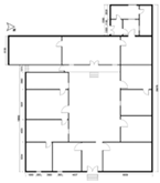
The courtyard layouts of traditional dwellings in southern Shaanxi show strong regional variation. They include both quadrangle courtyards, which are common in traditional Chinese architecture, and locally adapted skywell courtyards. Although these forms are generally enclosed, they differ from northern quadrangle courtyards and from the more refined skywell houses of southern China. In some areas, front rooms facing the street gradually developed into shopfront spaces, creating a distinctive mixed commercial–residential form. Constrained by local topographic conditions, the single-row courtyard layout emerged as the most prevalent form in the region, reflecting its strong adaptability to locally available materials. In stone-rich areas, dwellings were commonly constructed as slate or stone houses, whereas in bamboo-abundant regions, bamboo–timber composite structures were more frequently adopted (Table 3).
In terms of utility, courtyard-style residences were originally not single-purpose living spaces but multifunctional units integrating domestic life, production, and ritual activities. Courtyards supported daily household activities, crop drying, agricultural tool storage, temporary work, festive rituals, and neighborhood interaction, while also providing daylighting, ventilation, drainage, and a spatial order that reflected family hierarchy. Skywell residences were more common in compact street-based settlements or areas with active commercial exchange. A skywell improved daylighting and ventilation, organized rainwater drainage, and supported the front-shop–rear-residence pattern of mixed commercial and domestic use. Single-row residences were mainly responses to mountainous terrain and limited building land; their spatial organization emphasized contour adaptation, reduced construction cost, local material use, and basic residential and production-related functions.

3.4.2. Architectural Structure of Individual Buildings

(1)
Traditional dwellings in southern Shaanxi generally include entrance steps and a platform base. Three-tiered steps are most common, built of rammed earth or crushed stone and paved with gray stone slabs. Larger or higher-status residences often have seven-tiered steps for symbolic significance. Their platform bases are mainly stone: on flat terrain, low-embedded platforms with three-step entrances prevail, while in mountainous areas elevated stone bases using stepped or dry-laid masonry are widely applied to reduce moisture intrusion and enhance stability and ceremonial expression (Table 4).
(2)
The wall systems comprise the exterior walls and firebreak gable walls. The exterior walls are typically rammed earth, often reinforced with brick plinths to form earth–brick composite walls; multi-courtyard residences may use hollow-brick walls or exposed brickwork. In the stone-rich mountains, rough stone or schist masonry were used to form mottled “tiger-skin walls”. Firebreak gable walls, introduced in Huizhou architecture, became common in skywell dwellings, providing fire separation and stepped street-facing elevations, often “three-peak” or “five-peak”, with painted embellishments in ancestral halls and ritual buildings.
(3)
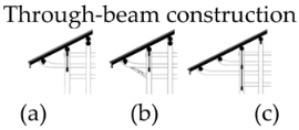
The structural frameworks follow the timber frame tradition but vary in terms of their materials and cultural influences. Ankang and Shangluo commonly employed hybrid systems combining post-and-lintel and through-beam construction, whereas Hanzhong is dominated by the through-beam system; mixed earth–timber and brick–timber forms are widespread.
(4)
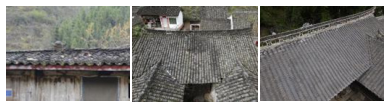
The roofs are mainly double-pitched, including flush gable and overhanging gable types, with the latter often used for skywell and courtyard residences. The ridges include plain ridges, ornamental brick ridges, and upturned ridges (plain ridges most prevalent). The roofing is dominated by flat tiles laid with cold overlay techniques using small grey tiles; slate tiles are frequent in mountainous areas.
(5)
The doors include framed plank doors, paneled doors in skywell courtyards, and interior plank or lattice-panel doors. The windows include vertical lattice, pivot lift, lattice panel, and high-set windows, with mullion design as a key ornamental element.
By overlaying the OLS- and GWR-identified driver regimes with the coded architectural form features, we observe systematic differences in the architectural configurations across spatial contexts. In zones where the hydrological coefficient is significant, the buildings more frequently present a consistent configuration of raised foundations, reinforced wall bases, and a more explicit drainage organization. In zones characterized by weaker topographic constraints and stronger road density coefficients, the buildings exhibit greater diversity in their courtyard depths and openness, with a stronger emphasis on courtyard enclosures and the organization of public spaces, and they predominantly adopt post-and-lintel construction. In zones where the slope and elevation coefficients are significant, courtyard spaces tend to be more uniform, buildings are typically constructed with through-beam construction, the use of locally available materials is more evident, and the construction detailing more frequently emphasizes structural stability and moisture protection.

3.5. Validation of Ecological Coupling Mechanisms Using PLS-SEM

PLS-SEM validation and path analysis of cross-scale evolutionary pathways: Firstly, a reliability and validity assessment of the model is conducted. In PLS-SEM, the model may include both formative and reflective indicators; their reliability is evaluated via outer weights and outer loadings, respectively. As a general rule, bootstrap-based inference is used, and the formative indicators are considered meaningful when the outer weights exceed 0.20 and are statistically significant. For the reflective indicators, LGBARIA et al. suggested a minimum acceptable loading of 0.40 as evidence of significance, whereas loadings above 0.70 typically indicate that the indicator sufficiently reflects the latent construct. In addition, multicollinearity should be assessed because high correlations among indicators can bias estimation; this is commonly evaluated using the variance inflation factor (VIF). Hair et al. proposed that a VIF < 10 is acceptable for collinearity diagnostics, while Diamantopoulos et al. argued for a stricter threshold of VIF < 3.3.
As shown in Table 2, all the formative indicators have outer weights greater than 0.20 and pass the bootstrap significance test. For the reflective indicators, all outer loadings exceed 0.70, except one loading of 0.558 (>0.40). The VIF values range from 1.000 to 3.011. Collectively, these results indicate that the measurement model demonstrates satisfactory reliability (Table 5).
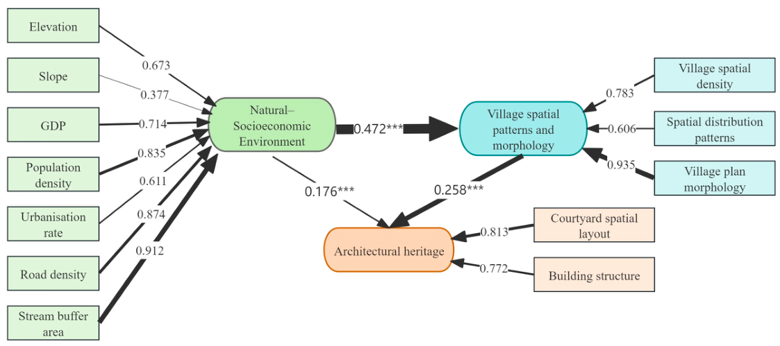
The structural model reveals significant cross-scale relationships among the three latent constructs. The natural–socioeconomic environment (E) has the strongest positive effect on village spatial pattern and morphology (P), with a standardized path coefficient of β = 0.472. This indicates that environmental and socioeconomic conditions play a fundamental role in shaping village distribution and morphological differentiation. The village spatial pattern and morphology (P) also has a positive effect on the architectural heritage (A), with β = 0.258, suggesting that more stable and organized settlement patterns are associated with better preservation of courtyard layouts and building structures. In addition, the natural–socioeconomic environment (E) retains a direct effect on the architectural heritage (A), with β = 0.176. These results indicate that P functions as a partial mediating layer between E and A (Table 6).
At the measurement level of the model, the latent construct natural–socioeconomic environment is mainly driven by indicators such as road density, urbanization rate, and population density; the elevation and the water system buffer provide moderate loading support, whereas the loading of slope is comparatively lower. The latent construct village spatial pattern and morphology shows the highest loading for plan morphology, followed by spatial density and distribution pattern. The latent construct architectural heritage is jointly reflected by the courtyard spatial layout and building structure, with loadings both above 0.70. Overall, the model demonstrates good theoretical consistency and statistical significance in both the structural paths and the measurement layer, providing robust empirical evidence for an eco-coupling mechanism (Figure 9).
From the perspective of E–P–A eco-coupling, the sustainable development of traditional villages is not driven by a single factor, but emerges from the long-term interaction among the macro-scale environmental base (E), meso-scale spatial pattern (P), and micro-scale architectural heritage (A) within the same regional system. The E system—through topographic and hydrological conditions, resource endowments, and gradients of accessibility and development—provides the fundamental constraints and support for site selection, habitat safety, and development boundaries, functioning as an external “ecological field” for village formation and persistence. Building on this foundation, the P system translates the environmental conditions into a concrete spatial order and morphological structure; through clustering intensity, distribution patterns, and plan form it regulates human–land tensions and land-use efficiency and serves as a key mediating link for structural stability and functional flexibility. The A system, expressed in courtyard organization, construction systems, and detailing, embodies the accumulated long-term adaptation to environmental constraints and spatial patterns, and constitutes the core carrier through which cultural continuity and local identity are maintained. Accordingly, the E–P–A coupling mechanism implies that sustainable development under contemporary transformation pressures can be achieved only by respecting the natural and socioeconomic contexts, rationally guiding and optimizing settlement spatial patterns, and simultaneously conserving and activating architectural heritage and construction systems with strong local adaptability, thereby integrating environmental safety, spatial order, and cultural continuity.

4. Discussion

The spatial patterns and architectural heritage of traditional villages are co-formed through the interaction of natural conditions, socioeconomic dynamics, and historical–cultural processes [62,63]. Southern Shaanxi was selected as the study area because it lies within a north–south transitional zone with distinctive geographical characteristics, providing an appropriate human–environment context for this research. At the same time, traditional villages in southern Shaanxi are currently facing multiple pressures, including spatial restructuring and the gradual decline of architectural heritage. In response, this study adopts a multi-scale and interdisciplinary analytical framework. From integrated macro-, meso-, and micro-level perspectives, it systematically examines the spatial distribution patterns, settlement morphology types, and evolutionary mechanisms of architectural forms. Guided by explicit research hypotheses, a PLS-SEM approach is further employed to verify the cross-scale coupling relationships and establish a coherent logical closed loop. This framework not only helps reveal the intrinsic coupling logic of traditional village systems at the theoretical level, but also provides strategic support for heritage conservation and rural revitalization in practice.
The advancement of multi-scale and interdisciplinary research has provided new perspectives and methodological approaches for the academic study of traditional villages. On this basis, the comprehensive eco-coupling analytical framework developed in this study mainly includes the following components: (1) Traditional villages in southern Shaanxi exhibit an overall clustered distribution, with high-density concentrations in Hanbin, Shiquan, and Hanyin in Ankang, while the peripheral areas remain relatively scattered. This pattern indicates that natural factors—such as terrain, elevation, slope, and proximity to water systems—provide the fundamental constraints on settlement formation, while socioeconomic variables, including population density, transport accessibility, and moderate urbanization, also significantly influence their spatial persistence and evolution. (2) The morphology of traditional villages in southern Shaanxi is diverse and can be classified into clustered, linear, and scatter-shaped types. These differences reflect both the region’s transitional north–south geographic position and its long history of multi-ethnic and multicultural interaction, representing the integration of ecological adaptation, spatial order, and cultural continuity. (3) Traditional villages in southern Shaanxi express environmental adaptation and cultural symbolism through courtyard organization and architectural detailing. From an architectural heritage perspective, this study reveals the dynamic coupling among environmental adaptation, craftsmanship transmission, and cultural expression, and demonstrates that scientific documentation, material restoration, and craft reproduction support the maintenance of authenticity and continuity in architectural heritage. (4) Building on the multi-scale ecological coupling analysis, the PLS-SEM validates the cross-scale coupling pathways and confirms the research hypotheses, demonstrating that the sustainable development of traditional villages is not driven by a single factor but results from the long-term interaction among macro-level environmental conditions, meso-level spatial patterns, and micro-level architectural heritage within the same regional system.
Compared with existing studies, the contribution of this study does not lie in replacing established GIS-based spatial analytical methods, but in reorganizing them within a cross-scale eco-coupling framework and further extending the analytical chain to the architectural heritage level. In recent years, a large body of research has employed methods such as ArcGIS [64,65], Geodetector [6,56,66], and GWR [67,68] to identify the regional spatial distribution patterns of and influencing factors on traditional villages, substantially advancing the understanding of clustering characteristics, environmental constraints, and socioeconomic associations across different provincial and river basin scales. However, most of these studies have remained focused primarily on the macro-scale distribution layer, with relatively limited efforts to systematically integrate settlement morphology and architectural heritage evidence into a unified explanatory framework.
At the meso scale, existing morphological and typological studies have provided an important foundation for settlement classification and the identification of spatial order; however, morphology has often been treated as a descriptive endpoint rather than an explanatory mediating layer. The existing research has predominantly emphasized the diversity and spatial logic of village morphologies. For example, Lin et al. [12] analyzed Jiuguan Village using facility clustering, road network analysis, and spatial form indices, demonstrating the multifaceted influence of transportation systems on historical development processes and adaptive spatial patterns. Jiang et al. [69] employed the CityEngine platform in combination with digital and 3D visualization techniques to explore the self-organizing rules governing the spatial morphology of Xiaoxi Village, thereby contributing to landscape resource integration, feature assessment, optimization strategies, and spatial management. In contrast, this study defines village morphology as a mediating structural system that receives and translates the effects of macro-scale natural–socioeconomic gradients onto the architectural level. This treatment shifts morphology from a mere typological label to a mechanism-bearing component within a cross-scale analytical logic.
At the micro scale, the existing architectural heritage studies have often focused on typological documentation, material and thermal performance evaluation, or the analysis of individual building components. For example, Wang et al. [70] combined subjective surveys with objective measurements to evaluate indoor thermal comfort, proposing improvements to enclose the thermal performance and an evaluation framework for residents in cold regions. Similarly, Xie et al. [71] employed numerical simulations to assess the effects of insulation materials, glazing types, wall thickness, insulation layer configuration, and solar utilization on the energy performance of traditional buildings in Beijing. Building on this literature, the distinct contribution of this study lies in integrating courtyard organization, structural systems, wall foot detailing, roof–eaves configurations, and drainage characteristics into a comparative architectural-response framework that can be examined across different spatial regimes and interpreted under varying driver contexts. In other words, the architectural layer is no longer treated merely as a cultural inventory, but is instead understood as a locally adaptive response system with heritage science relevance, including aspects such as moisture control, drainage performance, terrain adaptation, and maintainability.
At the methodological level, many existing studies are able to identify “influencing factors” or describe multi-scale phenomena, but relatively few explicitly verify the causal relationships among these factors. By introducing PLS-SEM to test the cross-scale coupling logic, this study advances multi-scale analysis into a testable cross-scale path model, enabling the E–P–A relationships to be evaluated in terms of direct effects, indirect effects, and mediating effects.
Building on the above comparison with existing studies, the key advance of this study lies not only in integrating evidence across the macro, meso, and micro scales, but also in transforming this integration into a mechanistic interpretation of settlement morphology types and architectural heritage. Specifically, the influencing factors identified by OLS and GWR are fed back into the analyses of morphology types and architectural forms, and the typological elements are further operationalized into performance-relevant indicators. This shifts the study from a descriptive multi-scale juxtaposition toward an evidence-bounded cross-scale explanatory chain. This transition is critical for discussing the “eco-coupling mechanism,” because it moves coupling beyond a conceptual juxtaposition and reframes it as an interpretable set of linkages through which the natural–socioeconomic environment (E) is translated into architectural heritage (A) responses via the village spatial pattern and morphology (P).
The correspondences among the E–P–A systems reveal a stepwise cross-scale coupling process from the macro-scale driving mechanisms, to the meso-scale spatial organization, and further to the micro-scale architectural forms. On the one hand, areas with weaker topographic constraints and significant road density effects are more likely to form clustered villages, whereas areas with significant hydrological characteristics tend to generate linear villages organized along water-related geomorphic corridors; by contrast, steeper-slope or higher-elevation areas are more closely associated with scatter-shaped villages. On the other hand, from the perspective of heritage science and environmental adaptation, the traditional architectural system of southern Shaanxi is not a passive response to natural conditions; rather, it is the result of a regionally specific and integrated coping mechanism centered on the humid climate, steep terrain, and flood risk. Under the humid and high-rainfall conditions, the buildings reduce erosive exposure through construction strategies, such as raised foundations, reinforced wall bases, extended eaves, and explicit drainage organization. Under the topographic constraints, the settlement and building layouts follow contour lines, reflecting a spatial logic in which terrain adaptation is prioritized. In river valleys with higher flood risk, foundation elevation and clearly organized runoff and drainage paths are used to reduce risks of scouring and water accumulation. Taken together, these two major aspects not only demonstrate environmental adaptability, but also, in heritage science terms, embody risk reduction, improved maintainability, and more robust sustainability.
It should be noted that the sustainability of traditional housing typologies does not mean that their original functions can be fully preserved. In some traditional villages, courtyard-style, skywell, and single-row residences are being replaced to varying degrees by modern brick–concrete houses, newly built detached dwellings, and street-facing commercialized buildings. This transformation is not simply a matter of changing aesthetic preference; rather, it is driven by multiple practical factors. First, timber, earth, and stone structures often require relatively high maintenance costs and are vulnerable to material aging, wall dampness, and structural damage in humid and mountainous environments. Second, traditional houses often have limitations in terms of sanitation, heating, thermal insulation, parking, privacy, and the conveniences required by modern family life. Third, population outmigration and household miniaturization have weakened the social basis that once supported multi-generational cohabitation, agricultural production, and clan rituals in traditional courtyard houses. Finally, the spread of modern materials, standardized construction, and changing local building preferences has further accelerated the replacement of traditional housing typologies.

5. Conclusions

This study constructs an E–P–A eco-coupling framework to examine how the natural–socioeconomic environment, village spatial pattern, and architectural heritage interact across scales in the traditional villages of southern Shaanxi. Rather than treating the spatial distribution, settlement morphology, and architectural form as separate descriptive layers, the study links them into a cross-scale explanatory chain. The revised conclusions are as follows.
First, the spatial distribution of traditional villages in southern Shaanxi is highly uneven and shows a pattern of central concentration and peripheral sparsity. The core clusters are located mainly in Hanbin, Shiquan, and Hanyin in Ankang, while many peripheral counties contain scattered and low-density village groups. This finding suggests that conservation planning should not adopt a uniform regional policy. Instead, central Ankang should be treated as a priority conservation area where continuous village clusters, historical settlement corridors, and architectural heritage resources can be protected as an integrated cultural landscape. In the peripheral low-density areas, conservation should focus on network-based protection, selected key villages, and the maintenance of cultural routes rather than large-scale uniform intervention.
Second, the persistence of traditional villages is closely associated with specific environmental and socioeconomic thresholds. These villages are mainly distributed below 1000 m in elevation, on slopes of 5–20°, and within 1 km of water sources. They are also concentrated in areas with medium GDP levels, relatively low population density, moderate road density, and low-to-moderate urbanization intensity. These findings provide direct implications for planning control. Water-adjacent villages should prioritize river corridor protection, drainage improvement, and flood risk management; slope-based villages should strengthen foundation stability, retaining structures, and terrain-sensitive construction control; villages close to roads should balance accessibility improvement with the prevention of excessive reconstruction; and villages under higher urbanization pressure require stricter controls over new construction, façade alteration, and the replacement of traditional dwellings.
Third, three main village morphology types—clustered, linear, and scattered—correspond to different conservation priorities. Clustered villages, usually associated with weaker topographic constraints and stronger road effects, should be protected through the maintenance of street–alley networks, public spaces, courtyard continuity, and overall settlement texture. Linear villages, often distributed along rivers or transportation corridors, should emphasize the continuity of waterfront or roadside spatial sequences, the protection of front-shop–rear-residence patterns, and the control of linear expansion. Scattered villages, which are more closely related to slope and elevation constraints, require a different strategy: protection should focus on terrain adaptation, the stabilization of individual dwellings, the conservation of local materials, and the maintenance of dispersed cultural landscape units.
Fourth, architectural heritage in southern Shaanxi should be conserved not only as a set of visual forms but also as a system of environmental adaptation and daily use. Courtyard-style residences, skywell/patio residences, and single-row dwellings have different functional logics. Courtyards originally supported family organization, drying, storage, household rituals, ventilation, and daily interactions; skywells provided daylighting, ventilation, drainage, and support for compact commercial–residential use; single-row dwellings responded to mountainous terrain, limited land, and local material availability. Therefore, adaptive reuse should retain the useful spatial functions of courtyards and skywells while improving sanitation, heating, drainage, and structural safety. Repair work should prioritize stone foundations, raised platforms, reinforced wall bases, timber structural systems, roof drainage, eaves, and locally specific wall materials, because these elements directly support moisture control, terrain adaptation, and maintainability.
Fifth, the PLS-SEM results confirm that the natural–socioeconomic environment has the strongest effect on the village spatial pattern and morphology, while the village morphology further mediates the relationship between the environmental conditions and architectural heritage. This result indicates that architectural conservation cannot be separated from the wider settlement and environmental context. In practical terms, heritage protection should proceed through an integrated sequence: identifying environmental constraints, classifying village morphology, evaluating architectural heritage conditions, and then formulating differentiated conservation measures. This sequence provides a more operational pathway than treating each village or building as an isolated heritage object.
The conclusions of this study should be understood as regional-scale findings. They are useful for identifying conservation zones, selecting representative villages, classifying housing typologies, and formulating differentiated planning strategies in southern Shaanxi. However, they do not replace smaller-scale studies of individual villages, courtyards, or buildings. Future research should incorporate household interviews, current-use surveys, building pathology records, structural safety assessments, and detailed restoration evaluations to further improve the applicability of the framework to site-specific conservation practice.
Despite these findings, the study has limitations. (1) This study focuses on 57 national-level and 128 provincial-level traditional villages in southern Shaanxi; however, many locally designated villages that are not included in the national or provincial lists also retain substantial research value. Therefore, the sample scope of this study is concentrated on representative villages rather than achieving full coverage, and some limitations remain in terms of spatial representativeness. (2) The macro-level natural and socioeconomic drivers (e.g., climate, population, road networks, and urbanization) are inherently dynamic. As a result, analyses based on cross-sectional data from a single period are subject to temporal contextual dependency, and the estimated driver effects and threshold intervals may change as data are updated. (3) The methods employed in this study rely primarily on spatial data analysis and field investigations, and thus place greater emphasis on analyzing and identifying the current conditions of traditional villages, while lacking long-term tracking of historical evolution and social dynamics. Future research will further address these limitations in order to better support the conservation and development of traditional villages.

Author Contributions

Conceptualization, Y.L. and M.L.; methodology, M.L.; software, M.L.; validation, Y.L. and M.L.; formal analysis, M.L.; investigation, M.L.; resources, Y.L.; data curation, M.L.; writing—original draft preparation, M.L.; writing—review and editing, Y.L.; visualization, M.L.; supervision, Y.L.; project administration, Y.L.; funding acquisition, Y.L. All authors have read and agreed to the published version of the manuscript.

Funding

This study was funded by the National Social Science Foundation of China (Grant No. 22 and ZD227) and The Social Science Foundation of Shaanxi Province (Grant No. 2022J003).

Institutional Review Board Statement

Not applicable.

Informed Consent Statement

Not applicable.

Data Availability Statement

The original data presented in the study are openly available in the six batches of the National List of Traditional Vil-lages released since 2012 by the Ministry of Housing and Urban–Rural Development and other national departments.

Acknowledgments

The authors sincerely thank the local cultural and tourism workers, township workers, experts in the field of architecture, craftsmen, and residents of traditional villages in southern Shaanxi. They scored the importance of factors affecting traditional village dwellings based on their professional knowledge and experience, and contributed to the data collection in the article. Appreciation is further extended to the interdisciplinary field team from Shaanxi University of Science & Technology for their work on the mapping, documentation, and data processing.

Conflicts of Interest

The authors declare no conflicts of interest.

References

  1. Cai, H.; Yu, J.; Guo, Y. Spatial and temporal distribution and evolution of traditional villages in Xin ’an River Basin of China based on geographic detection and remote sensing technology. Ecol. Indic. 2025, 171, 113239. [Google Scholar] [CrossRef]
  2. Ministry of Housing and Urban-Rural Development of the People’s Republic of China. About Conducting a Survey of Traditional Villages. 2012. Available online: https://zjj.nc.gov.cn/nczfbzglj/zcwj/201204/1760980dfa97416ba089fee2dac5863f.shtml?f_link_type=f_linkinlinenote&flow_extra=eyJpbmxpbmVfZGlzcGxheV9wb3NpdGlvbiI6MCwiZG9jX3Bvc2l0aW9uIjowLCJkb2NfaWQiOiIzYzRjOWUwM2ZmNTkxMGM4LWZhMTg3NWRjOWRiMjBlMjEifQ%3D%3D (accessed on 8 April 2026).
  3. Fu, J.; Zhou, J.; Deng, Y. Heritage values of ancient vernacular residences in traditional villages in Western Hunan, China: Spatial patterns and influencing factors. Build. Environ. 2021, 188, 107473. [Google Scholar] [CrossRef]
  4. Jia, A.Q.; Liang, X.X.; Wen, X.; Yun, X.; Ren, L.J.; Yun, Y.X. GIS-Based Analysis of the Spatial Distribution and Influencing Factors of Traditional Villages in Hebei Province, China. Sustainability 2023, 15, 9089. [Google Scholar] [CrossRef]
  5. Ministry of Housing and Urban-Rural Development of the People’s Republic of China. China Urban-Rural Construction Statistical Yearbook; China Statistics Press: Beijing, China, 2020. [Google Scholar]
  6. Liu, W.X.; Xue, Y.; Shang, C. Spatial distribution analysis and driving factors of traditional villages in Henan province: A comprehensive approach via geospatial techniques and statistical models. Herit. Sci. 2023, 11, 185. [Google Scholar] [CrossRef]
  7. Ma, H.; Tong, Y. Spatial differentiation of traditional villages using ArcGIS and GeoDa: A case study of Southwest China. Ecol. Inform. 2022, 68, 101416. [Google Scholar] [CrossRef]
  8. Hou, X.; Cheng, B.; Yang, J. A quantitative study on the exterior wall texture of stone-built dwellings in traditional villages in China: A case study of the xisuo village in the Jiarong Tibetan area. J. Build. Eng. 2021, 42, 102357. [Google Scholar] [CrossRef]
  9. Shi, Y.; Wang, W.K.; Zhang, J.; Li, D.; Liu, F.; Li, W.S. UAV remote sensing and deep learning for assessing and optimizing architectural texture in traditional villages. npj Herit. Sci. 2025, 13, 325. [Google Scholar] [CrossRef]
  10. Zheng, F.; Song, Z.; Han, J.; Zhang, J. Modeling and hazard assessment for fire propagation in Chinese traditional village buildings—A network based method using UAV photogrammetry. Int. J. Disaster Risk Reduct. 2025, 122, 105443. [Google Scholar] [CrossRef]
  11. Bi, S.; Du, J.; Tian, Z.; Zhang, Y. Investigating the spatial distribution mechanisms of traditional villages from the human geography region: A case study of Jiangnan, China. Ecol. Inform. 2024, 81, 102649. [Google Scholar] [CrossRef]
  12. Lin, Z.R.; Liang, Y.; Liu, X.H. Study on spatial form evolution of traditional villages in Jiuguan under the influence of historic transportation network. Herit. Sci. 2024, 12, 29. [Google Scholar] [CrossRef]
  13. Lian, M.C.; Wu, L.Y.; Li, Y.J.; Wang, X.A. Comprehensive Evaluation of Traditional Vernacular Dwelling Heritage Sustainability in Pingyao Ancient City, Shanxi. Sustainability 2026, 18, 4352. [Google Scholar] [CrossRef]
  14. Huang, Y.; Huang, Y.; Chen, Y.; Yang, S. Spatial evolution of traditional waterside settlements south of the Yangtze River and the distribution of settlement heritage: Evidence from the Nanxi River Basin. npj Herit. Sci. 2025, 13, 62. [Google Scholar] [CrossRef]
  15. Li, J.; Wu, Y.; Yang, C. Collective property right: Economic anthropological analysis of the distribution of tourism benefits in traditional villages. Guangxi Ethn. Stud. 2025, 02, 108–117. [Google Scholar]
  16. Wang, D.; Zhu, Y.; Zhao, M.; Lv, Q. Multi-dimensional hollowing characteristics of traditional villages and its influence mechanism based on the micro-scale: A case study of Dongcun Village in Suzhou, China. Land Use Policy 2021, 101, 105146. [Google Scholar] [CrossRef]
  17. Wang, M.; Chen, X. Multiperspective Theoretical Approaches to the Anthropological Research on the Traditional Villages of China. J. Yunnan Minzu Univ. 2023, 40, 79–88. [Google Scholar]
  18. Chen, X.; Xie, W.; Li, H. The spatial evolution process, characteristics and driving factors of traditional villages from the perspective of the cultural ecosystem: A case study of Chengkan Village. Habitat Int. 2020, 104, 102250. [Google Scholar] [CrossRef]
  19. Wang, S.; Liping, Y.; Arif, M. Evolutionary analysis of ecological-production-living space-carrying capacity in tourism-centric traditional villages in Guangxi, China. J. Environ. Manag. 2025, 375, 124182. [Google Scholar] [CrossRef]
  20. Zhong, Q.; Fu, H.; Yan, J.; Li, Z. How does energy utilization affect rural sustainability development in traditional villages? Re-examination from the coupling coordination degree of atmosphere-ecology-socioeconomics system. Build. Environ. 2024, 257, 111541. [Google Scholar] [CrossRef]
  21. Yuan, M.; Xian, Q.; Huang, Q.; Yang, C.; Shu, J.; Yao, C.; Pan, H. Research on ecological security pattern based on the paradigm of “portray-assessment-construction-validation”—Minjiang River Basin as an example. J. Environ. Manag. 2025, 394, 127553. [Google Scholar] [CrossRef] [PubMed]
  22. Zhou, M.; Yin, P.; Cui, J.; Lou, H.; Yang, Z.; Liu, J.; Peng, C. From pixels to 3D models: Mask2Former-driven automated reconstruction of Jiangnan traditional villages using remote sensing images. J. Build. Eng. 2025, 114, 114277. [Google Scholar] [CrossRef]
  23. Tang, C.; Yang, Y.; Liu, Y.; Xiao, X. Comprehensive evaluation of the cultural inheritance level of tourism-oriented traditional villages: The example of Beijing. Tour. Manag. Perspect. 2023, 48, 101166. [Google Scholar] [CrossRef]
  24. Li, Y.A.; Ismail, M.A.; Aminuddin, A. How has rural tourism influenced the sustainable development of traditional villages? A systematic literature review. Heliyon 2024, 10, e25627. [Google Scholar] [CrossRef]
  25. Palang, H.; Helmfrid, S.; Antrop, M.; Alumäe, H. Rural Landscapes: Past processes and future strategies. Landsc. Urban Plan. 2005, 70, 3–8. [Google Scholar] [CrossRef]
  26. Zheng, X.L.; Herman, S.S.B.; Salih, S.A.; Ismail, S.B. Sustainable Characteristics of Traditional Villages: A Systematic Literature Review Based on the Four-Pillar Theory of Sustainable Development. Sustainability 2024, 16, 10352. [Google Scholar] [CrossRef]
  27. Duan, Y.P.; Yan, L.Q.; Lai, Z.L.; Chen, Q.T.; Sun, Y.Y.; Zhang, L. The spatial form of traditional villages in Fuzhou area of Jiangxi Province determined via GIS methods. Front. Earth Sci. 2025, 19, 80–92. [Google Scholar] [CrossRef]
  28. Li, X.; Yang, Y.; Sun, C.; Fan, Y. Investigation, Evaluation, and Dynamic Monitoring of Traditional Chinese Village Buildings Based on Unmanned Aerial Vehicle Images and Deep Learning Methods. Sustainability 2024, 16, 8954. [Google Scholar] [CrossRef]
  29. Chen, Y.; Li, R. Spatial Distribution and Type Division of Traditional Villages in Zhejiang Province. Sustainability 2024, 16, 5262. [Google Scholar] [CrossRef]
  30. Hu, X.; Li, H.; Zhang, X.; Chen, X.; Yuan, Y. Multi-dimensionality and the totality of rural spatial restructuring from the perspective of the rural space system: A case study of traditional villages in the ancient Huizhou region, China. Habitat Int. 2019, 94, 102062. [Google Scholar] [CrossRef]
  31. Wu, K.; Su, W.; Ye, S.A.; Li, W.; Cao, Y.; Jia, Z. Analysis on the geographical pattern and driving force of traditional villages based on GIS and Geodetector: A case study of Guizhou, China. Sci. Rep. 2023, 13, 20659. [Google Scholar] [CrossRef]
  32. Yu, C.; Zhou, Z.; Gao, J.; Zhang, X.; Zheng, Q.; Liu, Z.; Ma, Z.; He, W.; Wen, S. Multi-scale comparison of the formation mechanisms in landscape genes of traditional villages. Sci. Rep. 2025, 15, 4126. [Google Scholar] [CrossRef]
  33. Zhu, J.; Xu, W.; Xiao, Y.; Shi, J.; Hu, X.; Yan, B. Temporal and spatial patterns of traditional village distribution evolution in Xiangxi, China: Identifying multidimensional influential factors and conservation significance. Herit. Sci. 2023, 11, 261. [Google Scholar]
  34. Yue, K.; Yin, C.; Shan, J. Agglomeration phenomena and evolutionary patterns of contemporary architectural interventions in traditional villages: An empirical analysis from 211 cases in Songyang County, China. Habitat Int. 2025, 166, 103571. [Google Scholar] [CrossRef]
  35. Chen, L.; Zhong, Q.; Li, Z. Analysis of spatial characteristics and influence mechanism of human settlement suitability in traditional villages based on multi-scale geographically weighted regression model: A case study of Hunan province. Ecol. Indic. 2023, 154, 110828. [Google Scholar] [CrossRef]
  36. Huang, Y.; Huang, Y.; Chen, Y.; Yan, Y.; Zheng, L.; Ying, Z. Interpretation of the Jiangnan Landscape and Countryside (Shan-Shui) Pattern: Evidence from the Classification and Spatial Form of Traditional Settlements in the Nanxi River Basin. Buildings 2025, 15, 413. [Google Scholar] [CrossRef]
  37. Liu, C.; Cao, Y.; Yang, C.; Zhou, Y.; Ai, M. Pattern identification and analysis for the traditional village using low altitude UAV-borne remote sensing: Multifeatured geospatial data to support rural landscape investigation, documentation and management. J. Cult. Herit. 2020, 44, 185–195. [Google Scholar] [CrossRef]
  38. Pan, X.; Lin, Q.; Ye, S.Y.; Li, L.; Guo, L.; Harmon, B. Deep learning based approaches from semantic point clouds to semantic BIM models for heritage digital twin. Herit. Sci. 2024, 12, 65. [Google Scholar] [CrossRef]
  39. Wang, W.K.; Shi, Y.; Zhang, J.; Hu, L.J.; Li, S.; He, D.; Liu, F. Traditional Village Building Extraction Based on Improved Mask R-CNN: A Case Study of Beijing, China. Remote Sens. 2023, 15, 2616. [Google Scholar] [CrossRef]
  40. Fang, Q.; Li, Z. Cultural ecology cognition and heritage value of huizhou traditional villages. Heliyon 2022, 8, e12627. [Google Scholar] [CrossRef]
  41. Gao, J.; Wu, B. Revitalizing traditional villages through rural tourism: A case study of Yuanjia Village, Shaanxi Province, China. Tour. Manag. 2017, 63, 223–233. [Google Scholar] [CrossRef]
  42. Tang, C.C.; Liu, Y.R.; Wan, Z.W.; Liang, W.Q. Evaluation system and influencing paths for the integration of culture and tourism in traditional villages. J. Geogr. Sci. 2023, 33, 2489–2510. [Google Scholar] [CrossRef]
  43. Wei, K.X.; He, Y.X.; Wang, M.Q.; Zhu, R.; Wang, Z.X. Identification, inheritance and restoration of traditional village landscape gene: A case study of Lidipo Village in Tongchuan, Shaanxi Province. npj Herit. Sci. 2025, 13, 18. [Google Scholar] [CrossRef]
  44. Li, C.; Wu, K. Driving forces of the villages hollowing based on geographically weighted regression model: A case study of Longde County, the Ningxia Hui Autonomous Region, China. Nat. Hazards 2017, 89, 1059–1079. [Google Scholar] [CrossRef]
  45. Ma, Y.; Zhang, Q.; Huang, L. Spatial distribution characteristics and influencing factors of traditional villages in Fujian Province, China. Humanit. Soc. Sci. Commun. 2023, 10, 883. [Google Scholar] [CrossRef]
  46. Cao, K.R.; Liu, Y.; Cao, Y.H.; Wang, J.W.; Tian, Y.G. Construction and characteristic analysis of landscape gene maps of traditional villages along ancient Qin-Shu roads, Western China. Herit. Sci. 2024, 12, 37. [Google Scholar] [CrossRef]
  47. Deng, Y.Y.; Liang, S.Q.; Zhou, W.L.; Wang, P. Perspective on traditional village spatial order based on directed weighted networks: A case study of Banliang Village. Int. J. Digit. Earth 2024, 17, 2383430. [Google Scholar] [CrossRef]
  48. Gao, S.Q.; Wang, J.X.; Liu, S.P.; Xu, X.W.; Liao, Y.Q.; Zhang, Z.J.; Sun, T.Y. Spatio-temporal evolution characteristics and influencing factors of traditional villages in the Qiantang River Basin based on historical geographic information. npj Herit. Sci. 2025, 13, 134. [Google Scholar] [CrossRef]
  49. Zheng, X.Y.; Wu, J.H.; Deng, H.B. Spatial Distribution and Land Use of Traditional Villages in Southwest China. Sustainability 2021, 13, 6326. [Google Scholar] [CrossRef]
  50. Li, Z.; Yang, M.; Zhou, X.; Li, Z.; Li, H.; Zhai, F.; Zhang, Y.; Zhang, Y. Research on the spatial correlation and formation mechanism between traditional villages and rural tourism. Sci. Rep. 2023, 13, 8210. [Google Scholar] [CrossRef]
  51. Yuan, L.; Xu, L.; Zhang, Z.; Xu, Y. Traditional village clustered protection and utilization methods based on network science. npj Herit. Sci. 2025, 13, 140. [Google Scholar] [CrossRef]
  52. Xu, J.; Yang, K.; Yang, W.T.; Lu, Z.L.; Liu, D.; Wei, Y.J. Multi-objective optimization design for sunspace of traditional dwellings considering energy consumption and thermal comfort in Southern Shaanxi, China. Energy Rep. 2025, 13, 4867–4883. [Google Scholar] [CrossRef]
  53. Yang, Y.; Ling, S.; Zhang, T.; Yao, C.X. Three-dimensional ecological footprint assessment for ecologically sensitive areas: A case study of the Southern Qin Ling piedmont in Shaanxi, China. J. Clean. Prod. 2018, 194, 540–553. [Google Scholar] [CrossRef]
  54. Kang, H.; Tao, W.D.; Chang, Y.; Zhang, Y.; Li, X.X.; Chen, P. A feasible method for the division of ecological vulnerability and its driving forces in Southern Shaanxi. J. Clean. Prod. 2018, 205, 619–628. [Google Scholar] [CrossRef]
  55. Lian, M.; Li, Y. The Spatial Patterns and Architectural Form Characteristics of Chinese Traditional Villages: A Case Study of Guanzhong, Shaanxi Province. Sustainability 2024, 16, 9491. [Google Scholar] [CrossRef]
  56. Chen, W.X.; Yang, L.Y.; Wu, J.H.; Wu, J.H.; Wang, G.Z.; Bian, J.J.; Zeng, J.; Liu, Z.L. Spatio-temporal characteristics and influencing factors of traditional villages in the Yangtze River Basin: A Geodetector model. Herit. Sci. 2023, 11, 111. [Google Scholar] [CrossRef]
  57. Xiong, Y.; Zhang, J.P.; Yan, Y.; Sun, S.B.; Xu, X.Y.; Higueras, E. Effect of the spatial form of Jiangnan traditional villages on microclimate and human comfort. Sustain. Cities Soc. 2022, 87, 104136. [Google Scholar] [CrossRef]
  58. Wu, J.D.; Li, Z.; Zhong, Q.K.; Xie, L. Spatial morphological characteristics of traditional settlements: A comparative study along the Miaojiang Border Wall and Miaojiang Corridor in Hunan, China. Ain Shams Eng. J. 2024, 15, 12. [Google Scholar] [CrossRef]
  59. Han, W.Y.; Zhang, Y.; Xie, Y.; Yi, C.; Bai, Y.; Liu, Y.H. Sustainable and protection renovation of hui traditional dwellings in China: Thermal comfort on-site testing and investigation. Case Stud. Therm. Eng. 2025, 73, 106625. [Google Scholar] [CrossRef]
  60. Mustafa, F.A.; Ali, L.A. Common architectural characteristics of traditional courtyard houses in Erbil city. Ain Shams Eng. J. 2024, 15, 103003. [Google Scholar] [CrossRef]
  61. Zhang, X.C.; Cui, L.H.; Li, J.Y.; Liu, K.; Liu, L.L. Out-of-plane behavior of timber frame-masonry infill system in northwest China: Experimental test, numerical simulation and reinforcement method. Eng. Struct. 2025, 343, 121172. [Google Scholar] [CrossRef]
  62. Liu, Q.; Liao, Z.; Wu, Y.; Mulugeta Degefu, D.; Zhang, Y. Cultural Sustainability and Vitality of Chinese Vernacular Architecture: A Pedigree for the Spatial Art of Traditional Villages in Jiangnan Region. Sustainability 2019, 11, 6898. [Google Scholar] [CrossRef]
  63. Guo, Y.L.; He, P.Y.; Huang, J. Spatial and temporal interpretation of traditional village distribution in Anhui Province of China and its conservation significance. Environ. Dev. Sustain. 2025. [Google Scholar] [CrossRef]
  64. Huang, Y.; Ye, Z.; Zhang, Q.; Chen, Y.; Wu, W. Space Gene Quantification and Mapping of Traditional Settlements in Jiangnan Water Town: Evidence from Yubei Village in the Nanxi River Basin. Buildings 2025, 15, 2571. [Google Scholar] [CrossRef]
  65. Xiao, Y.; Chen, Y.; Huang, Y.; Yan, Y. Surface Protection Technologies for Earthen Sites in the 21st Century: Hotspots, Evolution, and Future Trends in Digitalization, Intelligence, and Sustainability. Coatings 2025, 15, 855. [Google Scholar] [CrossRef]
  66. Xiao, W.B.; Huang, E.; Li, C.C.; Li, H.P. Investigating the spatial distribution and influencing factors of traditional villages in Qiandongnan based on ArcGIS and geodetector. Sci. Rep. 2025, 15, 5786. [Google Scholar] [CrossRef] [PubMed]
  67. Yuan, X.; Li, Y.J.; Song, Y.H.; Lu, H.Y.; Wang, Y.; Ge, B.C.; Wang, J. Spatial Distribution Characteristics and Driving Factors of 777 Traditional Villages in Yunnan Province: A Study Based on GWR Model and Geodetector. Land 2024, 13, 2004. [Google Scholar] [CrossRef]
  68. Li, S.Y.; Song, Y.H.; Xu, H.; Li, Y.J.; Zhou, S.K. Spatial Distribution Characteristics and Driving Factors for Traditional Villages in Areas of China Based on GWR Modeling and Geodetector: A Case Study of the Awa Mountain Area. Sustainability 2023, 15, 3443. [Google Scholar] [CrossRef]
  69. Jiang, Y.J.; Li, N.; Wang, Z.Y. Parametric Reconstruction of Traditional Village Morphology Based on the Space Gene Perspective-The Case Study of Xiaoxi Village in Western Hunan, China. Sustainability 2023, 15, 2088. [Google Scholar] [CrossRef]
  70. Wang, Y.; Dong, Q.W.; Guo, H.K.; Yin, L.Y.; Gao, W.J.; Yao, W.X.; Sun, L.X. Indoor thermal comfort evaluation of traditional dwellings in cold region of China: A case study in Guangfu Ancient City. Energy Build. 2023, 288, 113028. [Google Scholar] [CrossRef]
  71. Xie, L.; Fan, L.; Zhang, D.; Liu, J. Passive Energy Conservation Strategies for Mitigating Energy Consumption and Reducing CO2 Emissions in Traditional Dwellings of Peking Area, China. Sustainability 2023, 15, 16459. [Google Scholar] [CrossRef]
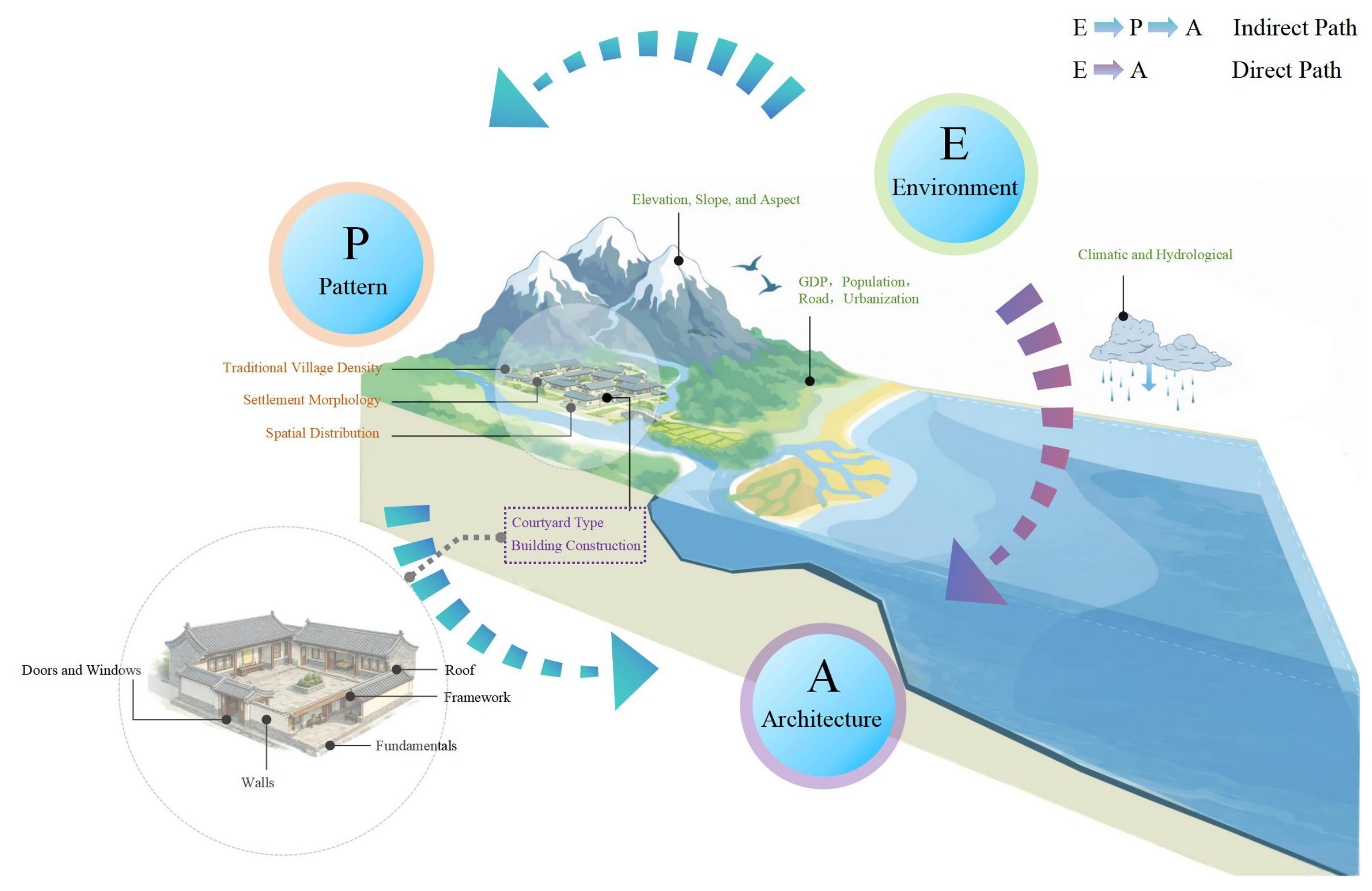
Figure 1. Schematic diagram of the ecological coupling mechanism.
Sustainability 18 05405 g001
Figure 2. Study area and village distribution.
Sustainability 18 05405 g002
Figure 3. Research framework.
Sustainability 18 05405 g003
Figure 4. Kernel density distribution pattern of traditional villages.
Sustainability 18 05405 g004
Figure 5. Geographic concentration index of traditional villages.
Sustainability 18 05405 g005
Figure 6. Global and local spatial autocorrelation of traditional village density.
Sustainability 18 05405 g006
Figure 7. The relationship between the spatial distribution of traditional villages and natural environmental factors.
Sustainability 18 05405 g007
Figure 8. Relationship between the distribution of traditional villages and socioeconomic factors.
Sustainability 18 05405 g008
Figure 9. Structural model path diagram with estimated path coefficient.
Sustainability 18 05405 g009
Table 1. Model observed variables.
Latent
Variables
Observed VariablesMeasurement Method
Natural–Socioeconomic EnvironmentElevationRepresented by the elevation values of the DEM grid at the village point or village center, the elevation-based classification can be assignedis defined as follows: below 100 m = 1; 100–200 m = 2; 200–300 m = 3; 300–500 m = 4; above 500 m = 5.
SlopeCalculate the slope rasters from the DEM data, with the slope values representing the gradient at each settlement point. Assign values based on the slope magnitude: <5° = 1; 5–10° = 2; 10–15° = 3; 15–25° = 4; >25° = 5.
GDPRepresented by the county (or township) GDP per unit area (RMB 10,000/km2) where the village is located, assign values based on the regional statistical quantiles or natural breaks: low = 1; below average = 2; medium = 3; above average = 4; high = 5.
Population densityRepresented by the population density (people/km2) of the county (or township) where the village is located, it is similarly divided into five levels using the quantile or natural breakpoint method: extremely low = 1; low = 2; medium = 3; high = 4; extremely high = 5.
Urbanization rateRepresented by the percentage of the county (or township) where the village is located that is classified as urban population, using data from statistical yearbooks. Assign values in tiers based on thresholds, such as 20%, 40%, 60%, and 80%, to reflect the urbanization gradient.
Road densityExpressed as the total road length per unit area (km/km2) within a village or grid, calculated using road vector data; assign values based on the density levels, with moderate density corresponding to medium-high grades.
Distance to water sourceThe Euclidean distance (km) from the village center to the nearest river is grouped and scored based on distance thresholds: <0.5 km = 5; 0.5–1 km = 4; 1–2 km = 3; 2–4 km = 2; >4 km = 1.
Village Spatial Pattern and MorphologyVillage spatial densityPerform a kernel density estimation on traditional village points using software such as ArcGIS. Select the appropriate search radius and grid size to extract the kernel density values for the grid cells containing village points.
Spatial distribution patternUsing the local Moran’s I (local spatial autocorrelation), with villages as the spatial units, a spatial weight matrix is constructed to calculate the local I value or Z value for each village. This serves to characterize the degree of clustering or dispersion at its location.
Plan morphologyBased on the village’s boundary contours and building distribution patterns, settlements are classified into cluster-type, linear-type, and scatter-shaped-type categories. Within the model, these classifications are represented through dummy variable coding (e.g., cluster-type = 1, others = 0) or assigned in an ordinal form according to their dominant spatial morphological characteristics.
Architectural HeritageCourtyard spatial layoutThrough field surveys and mapping, traditional courtyard houses or multi-courtyard layouts within a village are evaluated on a scale of 1 to 5. The average score is calculated as the “Courtyard Spatial Layout Index.”
Individual building structureBased on 3–4 structural elements—including the structural system, number of bays and depth, roof and eaves construction, and joint detailing—typical traditional dwellings within a village are rated on a scale of 0–1 or 1–5. After weighted summation and normalization, the “individual building construction index” is derived; at the village level, the average value of sampled buildings is calculated.
Table 2. Morphological classification of traditional villages.
Morphological TypeLayout PlanExisting VillagesBasic Characteristics
Clump shapedSustainability 18 05405 i001Sustainability 18 05405 i002• Clustered villages represent a typical concentrated settlement form, generally developing under relatively favorable natural conditions.
• Their spatial structure is characterized by high compactness and strong centralization.
• They enable efficient land use while reinforcing social cohesion and defensive capacity.
Line shapedSustainability 18 05405 i003Sustainability 18 05405 i004• Linear villages exhibit a transportation-oriented and watercourse-dependent settlement pattern, with pronounced directionality and structural continuity.
• Their spatial organization is typically structured along roads or rivers as the primary axes, with residential units extending linearly to form a unified and orderly spatial arrangement.
• This form reflects an adaptive development model shaped by the combined influence of natural geographical constraints and transportation needs.
Scatter shapedSustainability 18 05405 i005Sustainability 18 05405 i006• Scattered settlements represent a terrain-constrained scatter-shaped settlement pattern, primarily shaped by mountainous topography and natural environmental limitations.
• These villages exhibit a loose spatial organization with indistinct boundaries, characterized by scatter-shaped residential clusters lacking clear centrality and social cohesion.
• Significant deficiencies are evident in transportation accessibility, economic development, and the provision of public services.
Table 3. Courtyard layout types and characteristics.
Courtyard TypeCourtyard NameLayout PlanCurrent SituationCourtyard Features
Courtyard-style residencesThe Guo Family Courtyard in Zhongshan VillageSustainability 18 05405 i007Sustainability 18 05405 i008• The Guo Family Compound is located in Zhongshan Village, Xunyang County, Shaanxi Province. Constructed during the mid-Qing Dynasty, it evolved from a private school into a three-courtyard compound.
• The architecture follows the natural hillside contours with a north–south orientation, forming an orderly layout that integrates harmoniously with the surrounding landscape.
• The stone carvings and gable wall craftsmanship exhibit high construction skill and reflect the regional characteristics and artistic values of southern Shaanxi vernacular architecture.
The Hu Family Courtyard in Yunzhen VillageSustainability 18 05405 i009Sustainability 18 05405 i010• The Hu Family Courtyard is situated in Yunzhen Village, Yungai Temple Town, Zhen’an County, Shangluo City, and was built in the late Qing Dynasty. It represents a typical three-sided courtyard residential form.
• The buildings align along the street and are divided into front and rear courtyards, creating a compact and well-organized spatial layout.
• The overall structure adopts a beam-and-post framework with gray tile roofing, gabled fireproof walls, and a bluestone foundation, reflecting the regional architectural style of southern Shaanxi dwellings.
The Sun Family Courtyard in Gaoshan VillageSustainability 18 05405 i011Sustainability 18 05405 i012• Gaoshan Village is located in the Qinling Mountains of Ankang and is characterized by complex mountainous terrain, with settlements predominantly distributed on hillsides and mountaintops.
• The Sun Family Compound is constructed against the mountainside with a north–south orientation and a clearly defined hierarchical layout shaped by elevation differences.
• The architecture employs combined post-and-lintel and beam-and-column systems, with stone extensively used for the foundations and steps, reflecting the ritual order and regional characteristics of mountain dwellings in southern Shaanxi.
Skywell (patio) residencesThe Skywell in the Old Street of ManchuanguanSustainability 18 05405 i013Sustainability 18 05405 i014• Manchuanguan Ancient Town is located in Shangluo, southern Shaanxi, along the historical boundary between the Qin and Chu regions. Its ancient streets predominantly follow a front-shop, rear-residence courtyard housing pattern with central courtyards.
• The residential layouts are compact and adopt hybrid brick-and-wood structural systems combining beam-and-post and post-and-lintel techniques, typically topped with gable roofs. The courtyard forms vary widely, integrating commercial and residential functions while reflecting a hierarchical spatial order and the regional architectural characteristics.
The Liu Family Courtyard in Yunzhen VillageSustainability 18 05405 i015Sustainability 18 05405 i016• Yunzhen Village is located at a transportation crossroads linking the Qin, Jin, and Shu regions, historically attracting merchant activity. Its ancient streets feature courtyard houses with shop-front spaces facing the street and residences arranged at the rear.
• The Liu Family Courtyard, a Qing Dynasty relic, exhibits a symmetrical layout organized around a central skywell with four-sided drainage converging inward.
• Constructed using brick-and-wood framing and rammed-earth walls, the buildings feature ornate ridge decorations that reflect the ritual order and the aesthetic characteristics of southern Shaanxi vernacular architecture.
No. 39, Old Street, Chengguan VillageSustainability 18 05405 i017Sustainability 18 05405 i018• Chengguan Village, located in Liuba County, Hanzhong, functions as a cultural node integrating Sichuan and Shaanxi traditions. Its historic streets are characterized by skywell courtyards, with shops fronting the street and residential spaces arranged behind.
• Courtyard No. 39 features a narrow layout centered on a skywell connecting the front and rear sections and is primarily constructed using beam-and-post structural systems.
• The gabled walls and extended eaves reflect an architectural fusion of Guanzhong and Bashu styles and demonstrate adaptation to the local environment.
Single-row residencesThe Stone-Paved House of the Wang Family in Wangzhuang VillageSustainability 18 05405 i019Sustainability 18 05405 i020• Wangzhuang Village is situated in the Qinba mountainous and hilly region of Hanbin District, Ankang. The dwellings are scattered along roadsides and hillsides, forming a scatter-shaped settlement pattern without distinct boundaries.
• The architectural forms are dominated by stone-slab houses with simple structures and practical functions, employing post-and-lintel frameworks constructed from locally sourced stone.
• Stone walls, stone tile roofs, and stone-heated beds exemplify the ingenuity of mountain dwellings in southern Shaanxi, emphasizing adaptation to local conditions and economic durability.
Table 4. Architectural structure of individual buildings and detailed construction.
Building ConstructionType CompositionCharacteristics
Building fundamentalsSustainability 18 05405 i021Sustainability 18 05405 i022• Residential buildings in southern Shaanxi predominantly feature square stone platforms, typically constructed using stone masonry with stepped or dry-laid techniques to enhance moisture resistance and structural stability.
• These platforms commonly incorporate three-step or seven-step bluestone staircases, which function both as circulation elements and as symbolic representations of household status and auspicious meaning.
Building frameworkSustainability 18 05405 i023
(a) Single-projecting eaves;
(b) Single-projecting eaves with corbels;
(c) Double-projecting eaves.
Post-and-lintel construction
Sustainability 18 05405 i024
Hybrid timber construction
Sustainability 18 05405 i025
• The primary structural system is a pier-and-beam framework composed of interconnected columns and beams with load-bearing purlins, forming a lightweight and flexible configuration well suited to small-scale buildings and efficient material use.
• Hybrid structural systems are also widespread, combining through-beam and post-and-lintel construction methods and incorporating rammed-earth walls and gable walls as needed to balance structural stability, moisture control, and fire resistance.
• In some ceremonial buildings, inserted-beam structures are adopted, in which beam ends are embedded into columns; these structures are characterized by layered compositions and gently sloping roofs and are predominantly used in halls and ancestral temples.
Building wallsExterior wall
Sustainability 18 05405 i026
(a) Earthen wall (b) Brick wall
(c) Stone wall
Gable wall (firewall)
Sustainability 18 05405 i027
(a) Three-mountain style;
(b) Five-mountain style;
(c) Arch Style.
• Exterior walls are mainly constructed of rammed earth, brick, or stone masonry. Through the combined use of these three materials, distinctive regional wall forms emerge, including locally recognized features, such as “tiger-skin” walls.
• Gabled firewalls are widely applied in front-shop–back-dwelling residences and commonly appear in tiered “three-peak” or “five-peak” configurations, serving both fireproofing and decorative functions and reflecting the architectural artistry of southern Shaanxi dwellings.
Building roofRoof ridge
Sustainability 18 05405 i028
(a) Plain ridge tile;
(b) Decorative ridge tile;
(c) Curved ridge tile.
Roof tile
Sustainability 18 05405 i029
(a) Cold-laid tiles (b) Slate tiles
• Roofs in southern Shaanxi predominantly adopt gable or hip-and-gable double-sloped forms, with exposed ridge tiles being a common feature. The degree of roof ornamentation often corresponds to the social standing of the household.
• Roofing materials are mainly flat tiles, small blue-gray tiles, or slate tiles, while barrel tiles are additionally employed in mountainous areas and in larger buildings.
Doors and windowsBuilding doors
Sustainability 18 05405 i030
(a) Framed panel door
(b) Street-facing panel door
Building windows
Sustainability 18 05405 i031
(a) Fixed window;
(b) Casement window;
(c) Sash window;
(d) High window.
• Framed panel doors are widely used. Elaborately decorated main entrances indicate household status, whereas removable panel doors are commonly applied in shops and residential entrances. Interior partition doors contribute to improved natural lighting and visual quality.
• Window forms are diverse, including vertical-slat windows, casement windows, lattice windows, and high windows. Together, these designs achieve a balance between daylighting, ventilation, and decorative expression.
Table 5. Results of validity assessment and collinearity (VIF) diagnostics.
Latent ConstructIndicator
(Observed Variable)
Outer WeightOuter LoadingOuter VIF Valuesp-Value
Natural–Socioeconomic EnvironmentElevation0.673-1.0130.000
Slope0.377-1.0130.004
GDP-0.7142.0720.000
Population density-0.8351.0010.062
Urbanization rate-0.6111.0790.000
Road density-0.8741.0790.037
Distance to water source-0.9121.2430.000
Village Spatial Pattern and MorphologyVillage spatial density-0.7832.0510.000
Spatial distribution pattern-0.6061.9820.016
Plan morphology-0.9351.7710.000
Architectural HeritageCourtyard spatial layout-0.8133.0010.000
Individual building structure-0.7722.6750.072
Table 6. Path coefficients of the structural model.
Structural Relationship Between Latent ConstructsPath Coefficient
Natural–Socioeconomic Environment → Village Spatial Pattern and Morphology0.472
Village Spatial Pattern and Morphology → Architectural Heritage0.258
Natural–Socioeconomic Environment → Architectural Heritage0.176
Disclaimer/Publisher’s Note: The statements, opinions and data contained in all publications are solely those of the individual author(s) and contributor(s) and not of MDPI and/or the editor(s). MDPI and/or the editor(s) disclaim responsibility for any injury to people or property resulting from any ideas, methods, instructions or products referred to in the content.