Natural Endowments and Planning Interventions: The Spatio-Temporal Evolution and Policy Drivers of Urban Park Distribution in Shenzhen


Abstract
1. Introduction
1.1. Urban–Nature and Topography Studies
1.2. Research on the Temporal and Spatial Distribution of Urban Parks
1.3. Urbanisation and Urban Parks in Post-Mao China
2. Materials and Methods
3. Results
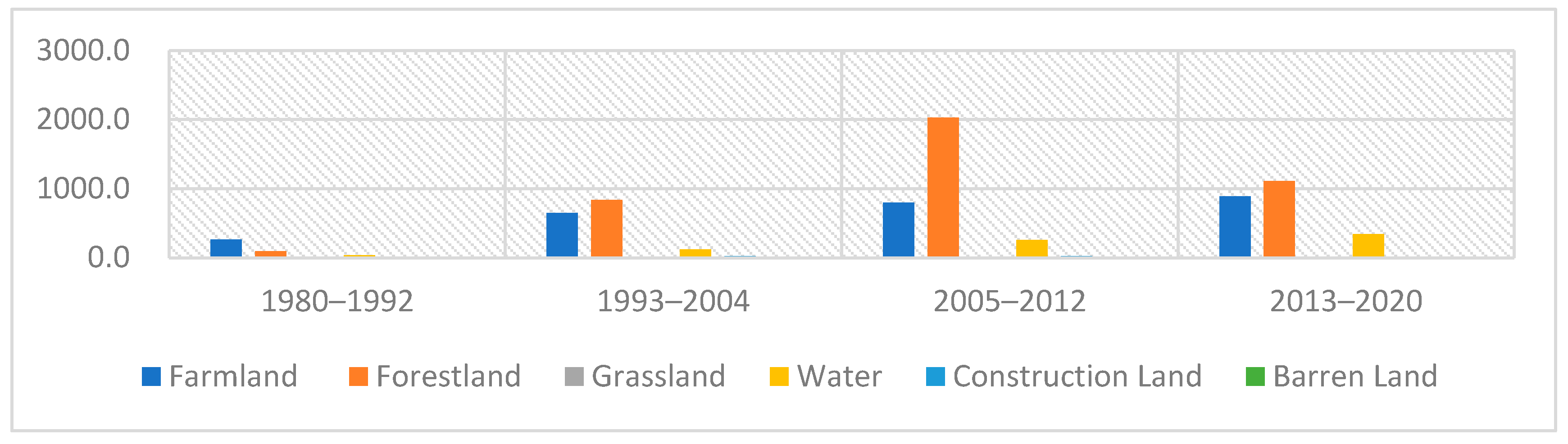
3.1. Area and Number
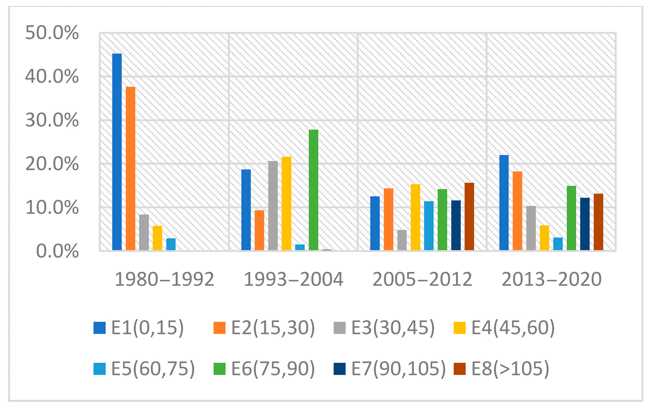
3.2. Slope and Elevation
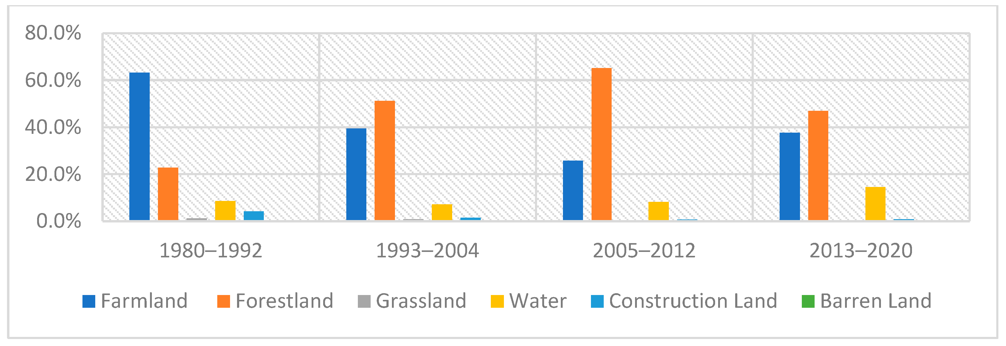
3.3. Land Use
4. Urban Parks’ Topographical Evolution and Their Policy Contexts
4.1. From Plains to Mountains: Insufficient Space for Development
- Primary water source protection areas, scenic spots, nature reserves, contiguous high-quality farmland protection zones, forests, and country parks.
- Mountainous areas and forestland with slopes exceeding 25%, as well as highland with elevation surpassing 50 metres within the Special Economic Zone and 80 metres outside the SEZ.
- Major rivers, reservoirs, and wetlands.
- Environmental corridors and green spaces essential for maintaining ecosystem integrity.
- Islands and coastal land areas with significant ecological conservation value.
- Other regions that require basic ecological control.
- Major road and transportation facilities
- Municipal public utilities
- Tourism facilities
- Urban parks
- Facilities related to agriculture, education, and scientific research that are compatible with ecological and environmental protection.
4.2. From Farmland and Forestland to Sea: Changes in Land Use
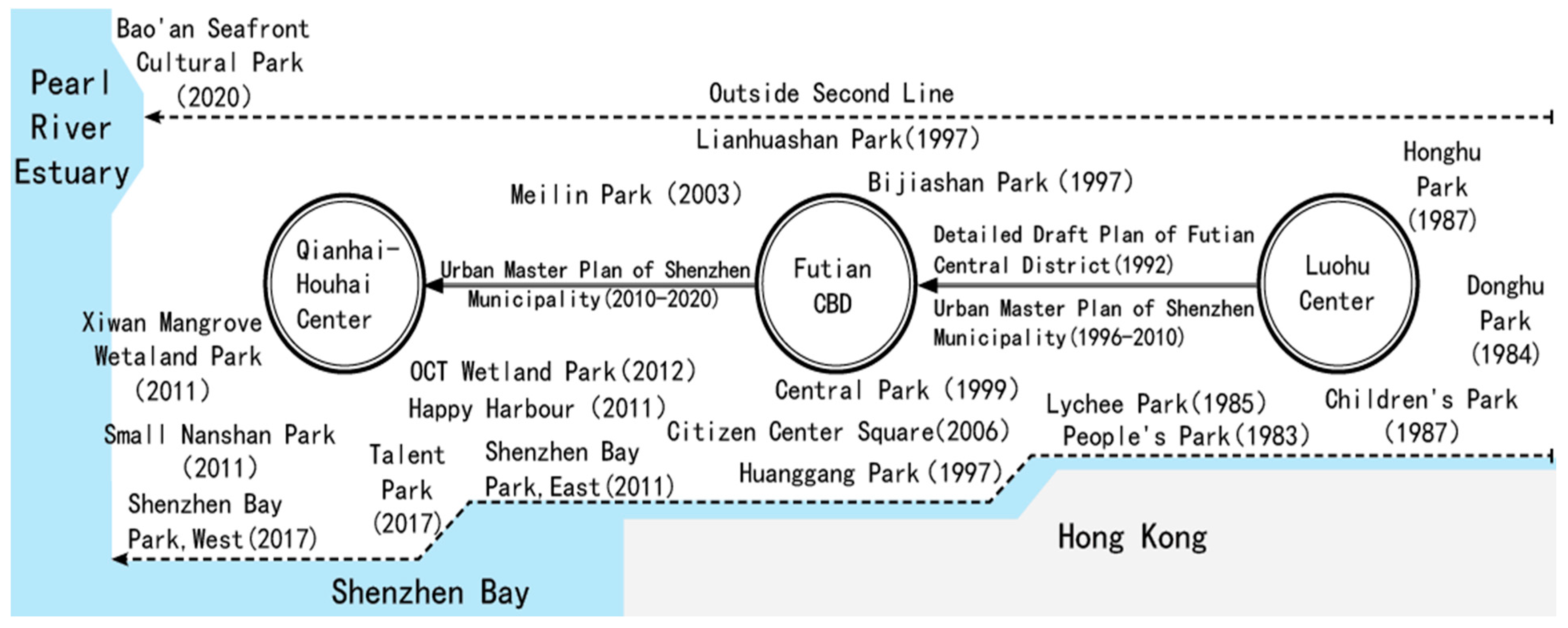
4.3. From City to Region: Land Reclamation and Regional Integration
5. Discussion
5.1. Government-Led Urbanisation and the Construction of Urban Parks
5.2. Regionalisation, Industrial Upgrading, and Environmental Equity
5.3. Research Limitations and Future Research
6. Conclusions
Author Contributions
Funding
Institutional Review Board Statement
Informed Consent Statement
Data Availability Statement
Conflicts of Interest
References
- Loughran, K. Imbricated spaces: The High Line, urban parks, and the cultural meaning of city and nature. Sociol. Theory 2016, 34, 311–334. [Google Scholar] [CrossRef] [Scilit]
- Konijnendijk, C.C.; Annerstedt, M.; Nielsen, A.B.; Maruthaveeran, S. Benefits of Urban Parks. A Systematic Review; A Report for IFPRA; IFPRA: Copenhagen, Denmark; Alnarp, Sweden, 2013; 70p. [Google Scholar]
- Kim, H.S.; Lee, G.E.; Lee, J.S.; Choi, Y. Understanding the local impact of urban park plans and park typology on housing price: A case study of the Busan metropolitan region, Korea. Landsc. Urban Plan. 2019, 184, 1–11. [Google Scholar] [CrossRef] [Scilit]
- Shan, L.; He, S. The role of peri-urban parks in enhancing urban green spaces accessibility in high-density contexts: An environmental justice perspective. Landsc. Urban Plan. 2025, 254, 105244. [Google Scholar] [CrossRef] [Scilit]
- Yang, L.; Lu, Y.; Cao, M.; Wang, R.; Chen, J. Assessing accessibility to peri-urban parks considering supply, demand, and traffic conditions. Landsc. Urban Plan. 2025, 257, 105313. [Google Scholar] [CrossRef] [Scilit]
- Xiao, Y.; Wang, Z.; Li, Z.; Tang, Z. An assessment of urban park access in Shanghai–Implications for the social equity in urban China. Landsc. Urban Plan. 2017, 157, 383–393. [Google Scholar] [CrossRef] [Scilit]
- Rigolon, A. A complex landscape of inequity in access to urban parks: A literature review. Landsc. Urban Plan. 2016, 153, 160–169. [Google Scholar] [CrossRef] [Scilit]
- O’Donnell, M.A.; Wong, W.; Bach, J. (Eds.) Learning from Shenzhen: China’s Post-Mao Experiment from Special Zone to Model City; University of Chicago Press: Chicago, IL, USA, 2019. [Google Scholar]
- Harvey, D. Justice, Nature, and the Geography of Difference; Blackwell Publishers: Hoboken, NJ, USA, 1996. [Google Scholar]
- Heynen, N. Urban political ecology II: The abolitionist century. Prog. Hum. Geogr. 2016, 40, 839–845. [Google Scholar] [CrossRef] [Scilit]
- Wachsmuth, D.; Angelo, H. Green and gray: New ideologies of nature in urban sustainability policy. Ann. Am. Assoc. Geogr. 2018, 108, 1038–1056. [Google Scholar] [CrossRef] [Scilit]
- Kirsch, S. Cultural geography I: Materialist turns. Prog. Hum. Geogr. 2013, 37, 433–441. [Google Scholar] [CrossRef] [Scilit]
- Tolia-Kelly, D.P. The geographies of cultural geography III: Material geographies, vibrant matters and risking surface geographies. Prog. Hum. Geogr. 2013, 37, 153–160. [Google Scholar] [CrossRef] [Scilit]
- Jackson, P. Rematerializing social and cultural geography. Soc. Cult. Geogr. 2000, 1, 9–14. [Google Scholar] [CrossRef] [Scilit]
- Anderson, B.; Wylie, J. On geography and materiality. Environ. Plan. A 2009, 41, 318–335. [Google Scholar] [CrossRef] [Scilit]
- McHarg, I.L. Design with Nature; American Museum of Natural History: New York, NY, USA, 1969. [Google Scholar]
- Starke, B.W.; Simonds, J.O. Landscape Architecture: A Manual of Environmental Planning and Design; McGraw-Hill Education: Columbus, OH, USA, 2013. [Google Scholar]
- Leatherbarrow, D. Topographical Stories: Studies in Landscape and Architecture; University of Pennsylvania Press: Philadelphia, PA, USA, 2004. [Google Scholar]
- Elden, S. Land, topography, territory. Prog. Hum. Geogr. 2010, 34, 799–817. [Google Scholar] [CrossRef] [Scilit]
- Gordillo, G. Topography as insurgent weapon: An affective geometry of warfare in the mountains of Afghanistan. Political Geogr. 2018, 64, 53–62. [Google Scholar] [CrossRef] [Scilit]
- Squire, R. Immersive topography: The US Navy, Sealab and Cold War undersea geopolitics. Area 2016, 48, 332–338. [Google Scholar] [CrossRef] [Scilit]
- Zhou, L.; Xiong, L.Y. Natural topographic controls on the spatial distribution of poverty-stricken counties in China. Appl. Geogr. 2018, 90, 282–292. [Google Scholar] [CrossRef] [Scilit]
- Gu, X.; Wang, H.; Lyu, J.; Zhang, M.; Ge, Q. Exploring the impacts of topography on characteristics of urban road network: A global empirical analysis. Cities 2025, 160, 105848. [Google Scholar] [CrossRef] [Scilit]
- Wang, X.; Wen, H.; Gui, B.; Liu, Z.; Yang, L. Urban topography, mountain landscape, and housing price: A heterogeneous investigation of the amenity effects in a mountainous city (Guiyang) from the vertical dimension. Appl. Geogr. 2025, 174, 103479. [Google Scholar] [CrossRef] [Scilit]
- Wang, C.; Zhang, Z.; Zhang, J.; Tao, F.; Chen, Y.; Ding, H. The effect of topography factors on rice production: A case study in Hunan Province. J. Geogr. Sci. 2019, 29, 287–305. [Google Scholar] [CrossRef] [Scilit]
- Rosenzweig, R.; Blackmar, E. The Park and the People: A History of Central Park; Cornell University Press: Ithaca, NY, USA, 1992. [Google Scholar]
- Castree, N. The nature of produced nature: Materiality and knowledge construction in Marxism. Antipode 1995, 27, 12–48. [Google Scholar] [CrossRef] [Scilit]
- Lang, S.; Rothenberg, J. Neoliberal urbanism, public space, and the greening of the growth machine: New York City’s High Line park. Environ. Plan. A Econ. Space 2017, 49, 1743–1761. [Google Scholar] [CrossRef] [Scilit]
- Loughran, K. Parks for profit: The High Line, growth machines, and the uneven development of urban public spaces. City Community 2014, 13, 49–68. [Google Scholar] [CrossRef] [Scilit]
- Tan, P.Y.; Samsudin, R. Effects of spatial scale on assessment of spatial equity of urban park provision. Landsc. Urban Plan. 2017, 158, 139–154. [Google Scholar] [CrossRef] [Scilit]
- Sang, Å.O.; Knez, I.; Gunnarsson, B.; Hedblom, M. The effects of naturalness, gender, and age on how urban green space is perceived and used. Urban For. Urban Green. 2016, 18, 268–276. [Google Scholar] [CrossRef] [Scilit]
- Rigolon, A.; Browning, M.; Jennings, V. Inequities in the quality of urban park systems: An environmental justice investigation of cities in the United States. Landsc. Urban Plan. 2018, 178, 156–169. [Google Scholar] [CrossRef] [Scilit]
- Black, K.J.; Richards, M. Eco-gentrification and who benefits from urban green amenities: NYC’s high Line. Landsc. Urban Plan. 2020, 204, 103900. [Google Scholar] [CrossRef] [Scilit]
- Kirkpatrick, J.B.; Daniels, G.D.; Davison, A. Temporal and spatial variation in garden and street trees in six eastern Australian cities. Landsc. Urban Plan. 2011, 101, 244–252. [Google Scholar] [CrossRef] [Scilit]
- Badiu, D.L.; Onose, D.A.; Niță, M.R.; Lafortezza, R. From “red” to green? A look into the evolution of green spaces in a post-socialist city. Landsc. Urban Plan. 2019, 187, 156–164. [Google Scholar] [CrossRef] [Scilit]
- Álvarez, R.F. Neoliberalism and parks: The urban political ecology of green public space in Mexico City. Soc. Hoy 2012, 23, 83–115. [Google Scholar]
- Zhang, S.; Liu, J.; Song, C.; Chan, C.S.; Pei, T.; Wenting, Y.; Xin, Z. Spatial-temporal distribution characteristics and evolution mechanism of urban parks in Beijing, China. Urban For. Urban Green. 2021, 64, 127265. [Google Scholar] [CrossRef] [Scilit]
- Macedo, J.; Haddad, M.A. Equitable distribution of open space: Using spatial analysis to evaluate urban parks in Curitiba, Brazil. Environ. Plan. B Plan. Des. 2016, 43, 1096–1117. [Google Scholar] [CrossRef] [Scilit]
- Sun, J.; Wang, X.; Chen, A.; Ma, Y.; Cui, M.; Piao, S. NDVI indicated characteristics of vegetation cover change in China’s metropolises over the last three decades. Environ. Monit. Assess. 2011, 179, 1–14. [Google Scholar] [CrossRef] [Scilit]
- Lin, G.C.S.; Li, X.; Yang, F.F.; Hu, F.Z. Strategizing urbanism in the era of neoliberalization: State power reshuffling, land development and municipal finance in urbanizing China. Urban Stud. 2015, 52, 1962–1982. [Google Scholar] [CrossRef] [Scilit]
- Zhang, L. Conceptualizing China’s urbanization under reforms. Habitat Int. 2008, 32, 452–470. [Google Scholar] [CrossRef] [Scilit]
- Xu, Y.; Li, J.; Jiao, S. Impacts of Chinese urbanization on farmers’ social networks: Evidence from the urbanization led by farmland requisition in Shanghai. J. Urban Plan. Dev. 2016, 142, 05015008. [Google Scholar] [CrossRef] [Scilit]
- Huang, Z.; Du, X.; Castillo, C.S.Z. How does urbanization affect farmland protection? Evidence from China. Resour. Conserv. Recycl. 2019, 145, 139–147. [Google Scholar] [CrossRef] [Scilit]
- Friedmann, J. Four theses in the study of China’s urbanization. Int. J. Urban Reg. Res. 2006, 30, 440–451. [Google Scholar] [CrossRef] [Scilit]
- Wu, F. Emerging Chinese cities: Implications for global urban studies. Prof. Geogr. 2016, 68, 338–348. [Google Scholar] [CrossRef] [Scilit]
- While, A.; Jonas, A.E.; Gibbs, D. The environment and the entrepreneurial city: Searching for the urban ‘sustainability; fix’ in Manchester and Leeds. Int. J. Urban Reg. Res. 2004, 28, 549–569. [Google Scholar] [CrossRef] [Scilit]
- Xu, Y.; Caprotti, F.; Zhang, W.; Pan, M. The socioenvironmental state and urban transitions: Eco-urbanism in China and the UK. Environ. Plan. E Nat. Space 2023, 6, 1682–1704. [Google Scholar] [CrossRef] [Scilit]
- Zhang, F.; Wu, F.; Lin, Y. The socio-ecological fix by multi-scalar states: The development of ‘Greenways of Paradise’ in Chengdu. Political Geogr. 2022, 98, 102736. [Google Scholar] [CrossRef] [Scilit]
- Liu, Z.; Chen, L.; Wang, J.; Hong, G. Difference and Potential of Park Green Space from the Perspective of Population Scale: A Case Study of Cities at Prefecture Level and above in China. Areal Res. Dev. 2021, 40, 40–44+55. [Google Scholar]
- Liu, X.; Wang, X.; Xue, Q. The Practice and Representation of Urban Parks in Shenzhen Special Economic Zone in the 1980s. Landsc. Archit. Front. 2022, 10, 70. [Google Scholar]
- Feng, S.; Zhuo, Y.; Xu, Z.; Chen, Y.; Li, G.; Wang, X. Nature’s neighborhood: The housing premium of urban parks in dense cities. Land 2024, 13, 1686. [Google Scholar] [CrossRef] [Scilit]
- Wu, C.; Ye, X.; Du, Q.; Luo, P. Spatial effects of accessibility to parks on housing prices in Shenzhen, China. Habitat Int. 2017, 63, 45–54. [Google Scholar] [CrossRef] [Scilit]
- Wang, Z.; Yan, G.; Wang, S. Fairness evaluation of landscape justice in urban park green space: A case study of the Daxing Part of Yizhuang New Town, Beijing. Sustainability 2022, 15, 370. [Google Scholar] [CrossRef] [Scilit]
- Wei, J.; Chen, M.; Chu, C.; Zhao, C.; Xia, X.; Li, Y. Assessing cultural ecosystem services supply–demand balance of urban parks in the context of old and new urban districts. Ecol. Indic. 2024, 159, 111688. [Google Scholar] [CrossRef] [Scilit]
- Thompson, K. The Grim Reality Hidden Beneath Freshkills Park’s Bright Facade. WR J. CAS Writ. Program 2016, 9. Available online: https://www.bu.edu/writingprogram/journal/past-issues/issue-9/thompson/ (accessed on 7 May 2026).
- Greater London Authority. Mayor Celebrates Delivery of 100 Pocket Parks Across London. 13 August 2015. Available online: https://www.london.gov.uk/press-releases/mayoral/mayor-celebrates-delivery-of-100-pocket-parks (accessed on 11 May 2026).
- Overmeyer, K.; Misselwitz, P. Urban Catalyst: Strategies for Temporary Use; Birkhäuser: Basel, Switzerland, 2011. [Google Scholar]
- Ministry of Housing and Urban-Rural Development. Announcement of the Ministry of Housing and Urban-Rural Development on Issuing the Industry Standard Standard for Classification of Urban Green Space. 28 November 2017. Available online: https://www.mohurd.gov.cn/gongkai/zc/wjk/art/2018/art_17339_236545.html (accessed on 13 May 2026).
- Zhong, J.; Guo, M.J. Documentation and Materials on Chinese Special Economic Zones; Social Sciences Academic Press: Beijing, China, 2010; Volume 2. [Google Scholar]
- Shenzhen Construction Bureau. Urban Development Strategy of Shenzhen; Shenzhen Construction Bureau: Shenzhen, China, 1989; pp. 16–17, unpublished. [Google Scholar]
- Wang, J.B. Research on the Evolution of Shenzhen’s Land System (1979–2020); China Financial & Economic Publishing House: Beijing, China, 2022. [Google Scholar]
- Shenzhen Municipal People’s Government. Notice on Issuing the “Measures for the Management of Urbanized Land in Bao’an and Longgang Districts of Shenzhen”. 26 June 2004. Available online: https://www.sz.gov.cn/zfgb/2004/gb396/content/post_5017278.html (accessed on 7 May 2026).
- Chen, K.; Yang, R.; Liu, B. Research on the Evolvement and Development of the Clusters Urban Spatial Structure of Shenzhen. Urban Dev. Stud. 2013, 20, 22–26. [Google Scholar]
- Shenzhen Municipal People’s Government. Shenzhen Basic Ecological Control Line Management Regulations. 17 October 2005. Available online: https://www.sz.gov.cn/zfgb/2005/gb461/content/post_4950100.html (accessed on 13 May 2026).
- Shenzhen Development and Reform Commission. Compilation of Shenzhen’s Five-Year Plans; Haitian Publishing House: Shenzhen, China, 2017; p. 4. [Google Scholar]
- Guangzhou Institute of Geography. Atlas of Natural Resources and Economic Development in Shenzhen; Science Press: Beijing, China, 1983; p. 128. [Google Scholar]
- Shenzhen Urban Planning and Natural Resources Bureau. Major Data Bulletin (Charts) of the Third National Land Survey in Shenzhen. 26 April 2022. Available online: https://pnr.sz.gov.cn/gkmlpt/content/9/9744/post_9744274.html#4290 (accessed on 7 May 2026).
- Shenzhen Urban Planning and Land Development Research Center. Shenzhen Land Resources; Science Press: Beijing, China, 2019; p. 118. [Google Scholar]
- Shenzhen General Institute of Architectural Design and Research. Forty Years of Shenzhen: Industry and City; China Architecture & Building Press: Beijing, China, 2019; pp. 15–16. [Google Scholar]
- Wen, W. Building Shenzhen into a National and Global Maritime Center City and Hub City. In Forty Years of Shenzhen Special Economic Zone: Oral History Interviews on Planning and Land Use; Shenzhen Urban Planning and Natural Resources Bureau: Shenzhen, China, 2021; p. 335, unpublished. [Google Scholar]
- Liu, X.; Yue, W. From insulative nature to developmental nature: Socio-natural transformation of the coastal space of Shenzhen Bay (1950–2017). Plan. Perspect. 2025, 1–25. [Google Scholar] [CrossRef] [Scilit]
- Shenzhen Urban Planning and Land Resources Commission. Guiding Urban Transformation Through Transformation Planning—Shenzhen Urban Master Plan (2010–2020); China Architecture & Building Press: Beijing, China, 2011; p. 64. [Google Scholar]
- China Development Research Foundation. Research on the Integration of City Clusters in China; China Development Press: Beijing, China, 2022; pp. 155–156. [Google Scholar]
- Castells, M. The Rise of the Network Society: The Information Age: Economy, Society, and Culture Volume I, 2nd ed.; Wiley-Blackwell: Hoboken, NJ, USA, 2011; Volume 12, pp. 440–452. [Google Scholar]
- Scott, A.J. A World in Emergence: Cities and Regions in the 21st Century; Edward Elgar Publishing: Cheltenham, UK, 2012; pp. 10–25. [Google Scholar]
- Sze, J. Fantasy Islands: Chinese Dreams and Ecological Fears in an Age of Climate Crisis; University of California Press: Berkeley, CA, USA, 2015; pp. 1–15. [Google Scholar]
- Rigolon, A.; Németh, J. Green gentrification or ‘just green enough’: Do park location, size and function affect whether a place gentrifies or not? Urban Stud. 2020, 57, 402–420. [Google Scholar] [CrossRef] [Scilit]
- Planning and Natural Resources Bureau of Shenzhen Municipality. Public Announcement of “Shenzhen Nanshan District Territorial Spatial Master Plan (2021–2035)” (Draft). 14 April 2023. Available online: https://www.sz.gov.cn/cn/xxgk/zfxxgj/tzgg/content/mpost_10544074.html (accessed on 7 May 2026).
- Shenzhen Nanshan District Government. Nanshan Becomes a Gathering Place for “Internet-Famous Parks,” Living Up to Its Reputation as the “District of a Hundred Parks”. 18 February 2021. Available online: http://www.szns.gov.cn/xxgk/qzfxxgkml/bmdt/content/post_8555918.html (accessed on 7 May 2026).
- Wai Wong, S. Urbanization as A Process of State Building: Local Governance Reforms in China. Int. J. Urban Reg. Res. 2015, 39, 912–926. [Google Scholar] [CrossRef] [Scilit]
- Hsia, C.J. A Glimpse of Devil Appearance: Planning and Design in Urban and Regional Process; Tonsan Publications Inc.: Taipei, Taiwan, 2015. [Google Scholar]
- Dooling, S. Ecological gentrification: A research agenda exploring justice in the city. Int. J. Urban Reg. Res. 2009, 33, 621–639. [Google Scholar] [CrossRef] [Scilit]
- Cai, W. Environment, aesthetics, technology, and gentrification from global north to global south: An integrated review of literature. J. Smart Cities 2022, 7, 5–12. [Google Scholar] [CrossRef] [Scilit]





| Area of Individual Park | Numbers | Proportion in Terms of Number | Area (Hm) | Proportion in Terms of Area |
|---|---|---|---|---|
| <1 Hm | 627 | 57.37% | 257.1 | 0.65% |
| 1–300 Hm | 445 | 40.71% | 7724.2 | 19.64% |
| >300 Hm | 21 | 1.92% | 31,354.6 | 79.71% |
| Sum | 1093 | 100.00% | 39,335.8 | 100.00% |
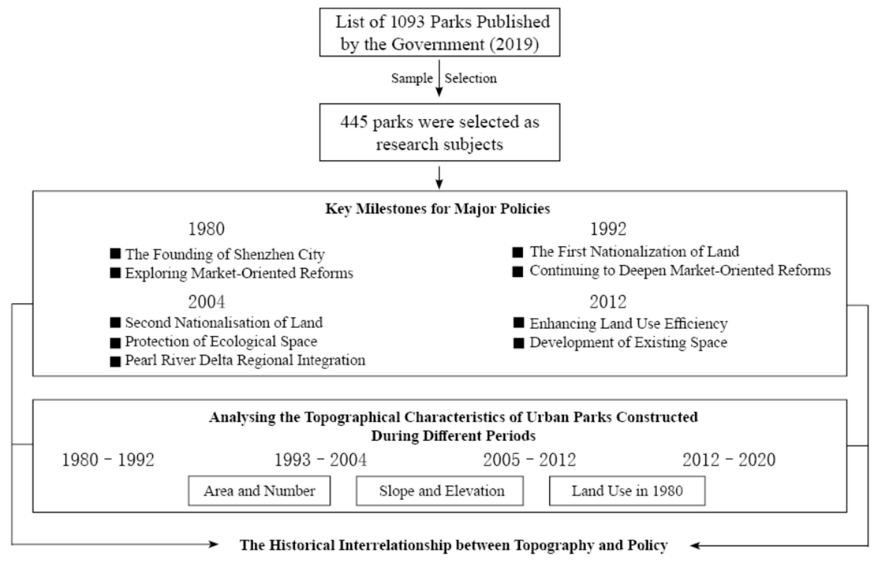
| Year | Policies | Significance |
|---|---|---|
| 1980 | Regulations on the Guangdong Special Economic Zone | Shenzhen was established as a city. |
| 1992 | Interim Provisions on Rural Urbanisation in the Shenzhen Special Economic Zone | Land in the four administrative districts south of the Second Line was nationalised. |
| 2005 | Measures on Urbanisation Land Management in Bao’an and Longgang Districts of Shenzhen Municipality Shenzhen Basic Ecological Control Line Management Regulations Plan for the Coordinated Development of the PRD Metropolitan Area | Land in the administrative districts north of the Second Line was nationalised. Protection of important ecological spaces witthin the city limits. The integration of the Pearl River Delta was included in the government’s agenda. |
| 2012 | Overall Plan for Land-Management System Reform of Shenzhen | Shenzhen’s spatial development entered a phase of stock utilisation. |
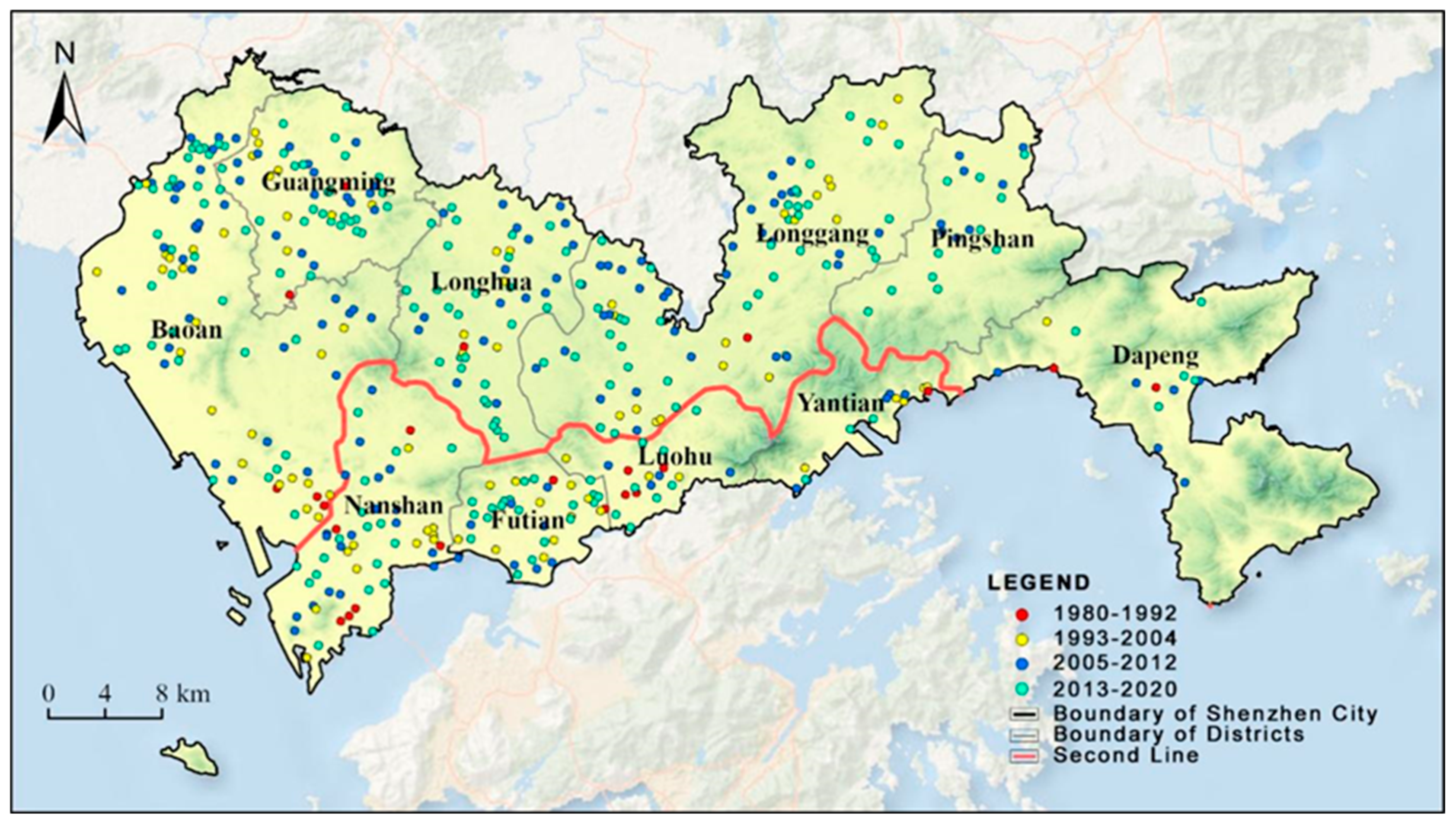
| Time Period | First Period (1980–1992) | Second Period (1993–2004) | |||||
|---|---|---|---|---|---|---|---|
| Location | Total Area | Number | Average Area | Total Area | Number | Average Area | |
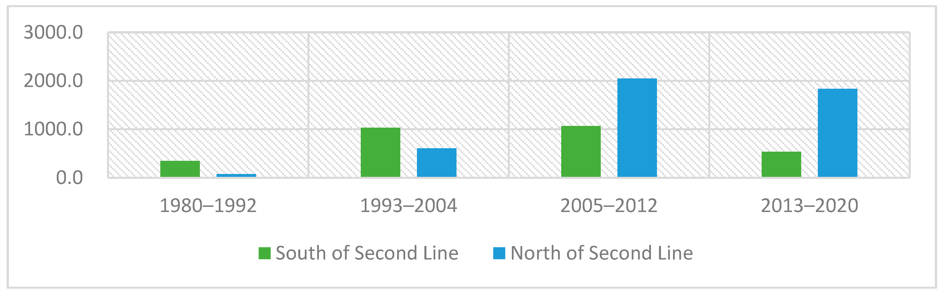
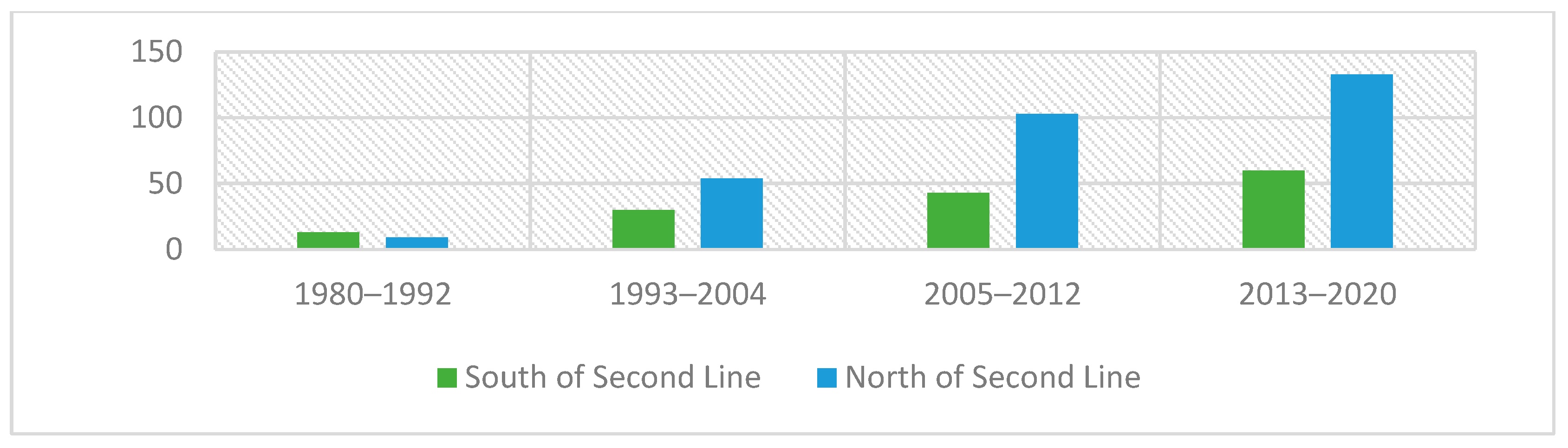
| South of Second Line | 347.2 | 13 | 26.7 | 1030.4 | 30 | 34.3 | |
| North of Second Line | 71.8 | 9 | 8.0 | 607.5 | 54 | 11.3 | |
| Total | 419.0 | 22 | 19.0 | 1637.9 | 84 | 19.5 | |
| Time Period | Third Period (2005–2012) | Fourth Period (2013–2020) | |||||
| Location | Total Area | Number | Average Area | Total Area | Number | Average Area | |
| South of Second Line | 1067.9 | 43 | 24.8 | 531.6 | 60 | 8.9 | |
| North of Second Line | 2044.3 | 103 | 19.8 | 1836.5 | 133 | 13.8 | |
| Total | 3112.2 | 146 | 21.3 | 2368.1 | 193 | 12.3 | |
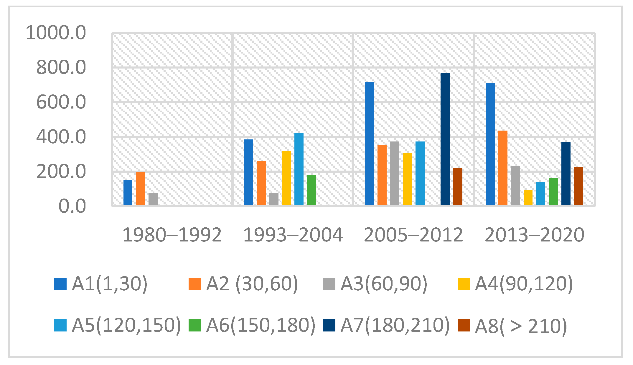
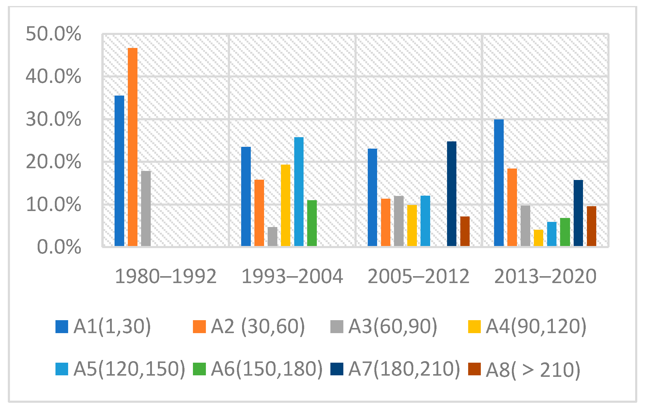
| Area (Hm) | A1 | A2 | A3 | A4 | A5 | A6 | A7 | A8 |
|---|---|---|---|---|---|---|---|---|
| 1–30 | 30–60 | 60–90 | 90–120 | 120–150 | 150–180 | 180–210 | >210 | |
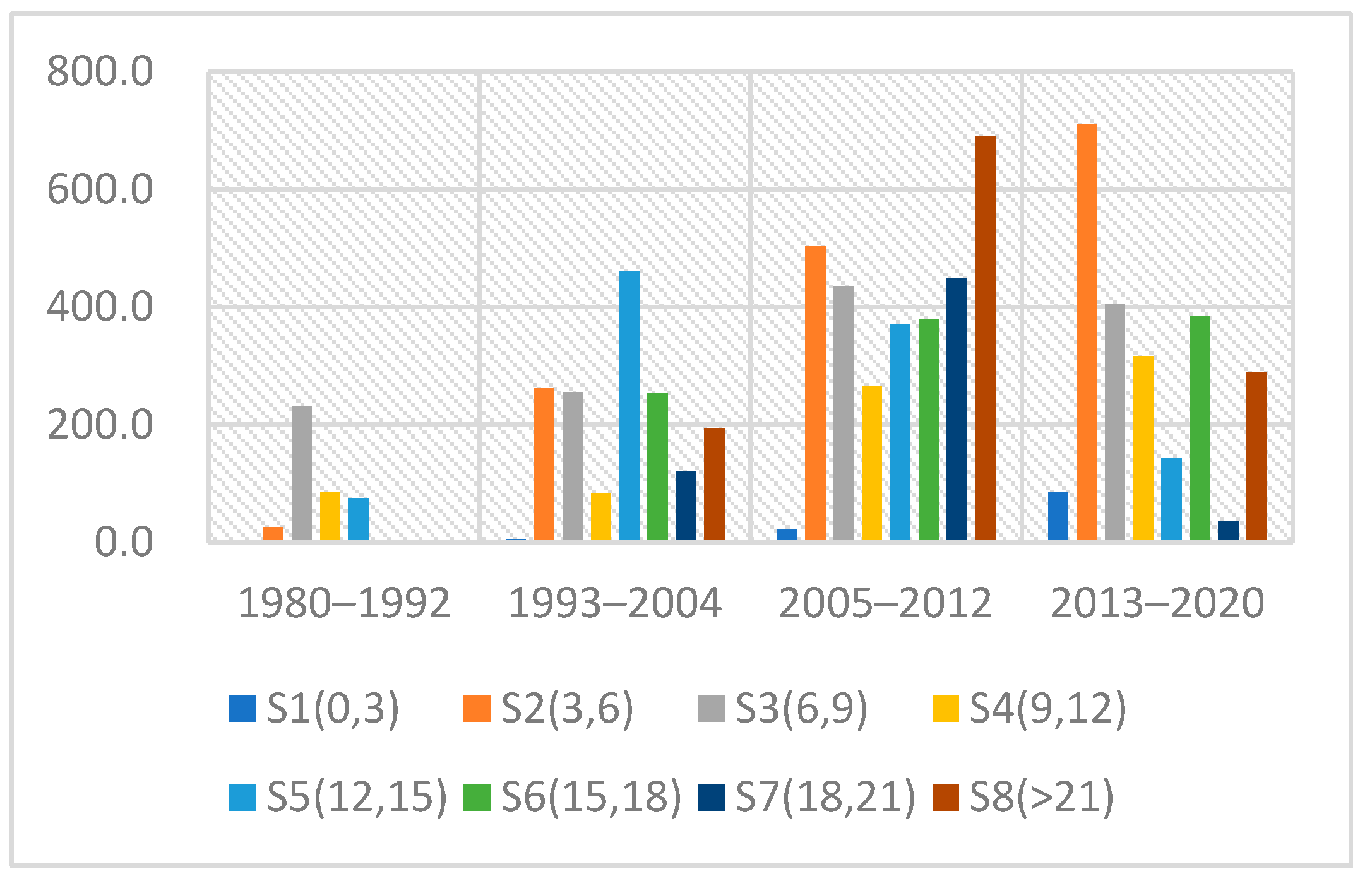
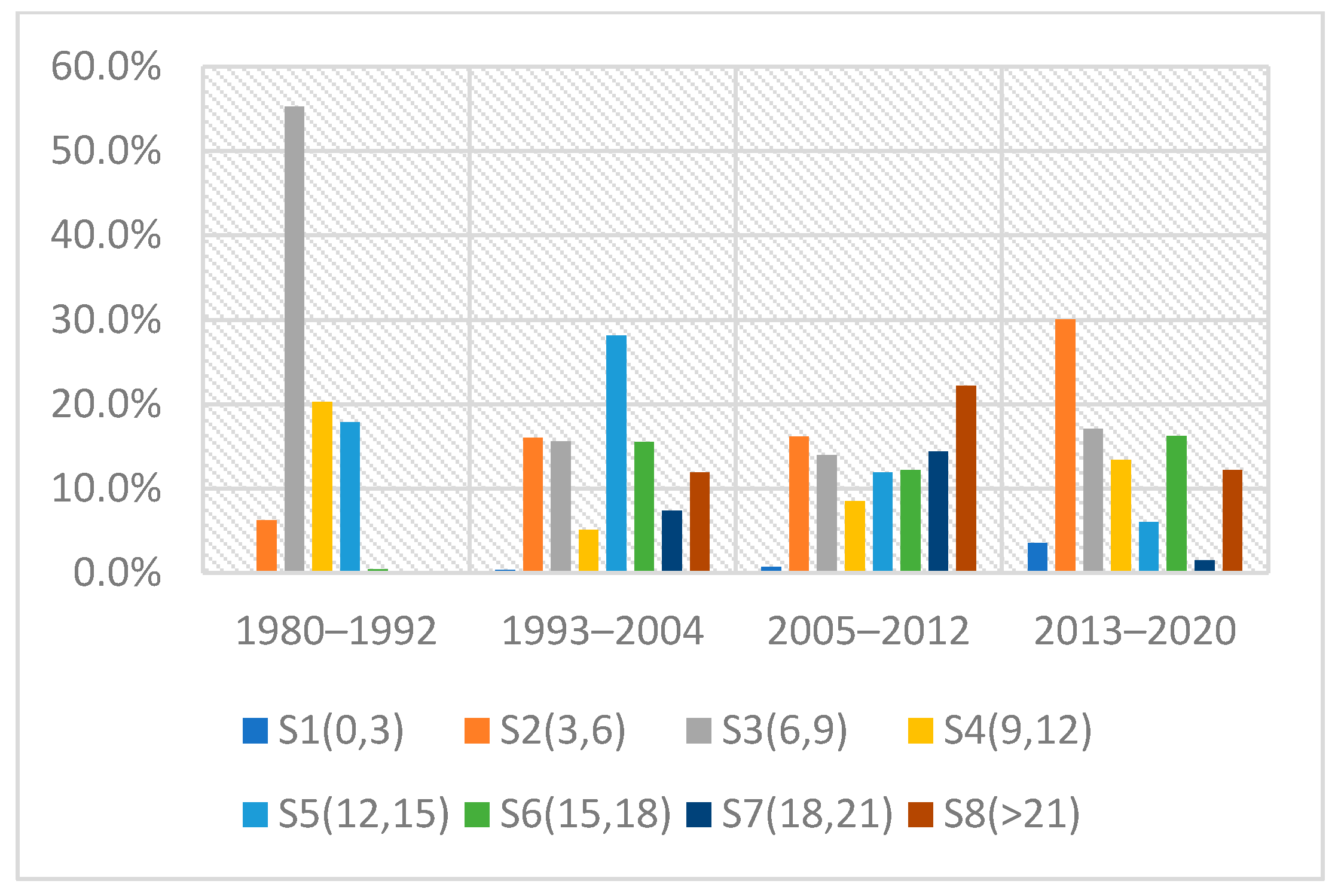
| Average Slope (°) | S1 | S2 | S3 | S4 | S5 | S6 | S7 | S8 |
| 0–3 | 3–6 | 6–9 | 9–12 | 12–15 | 15–18 | 18–21 | >21 | |
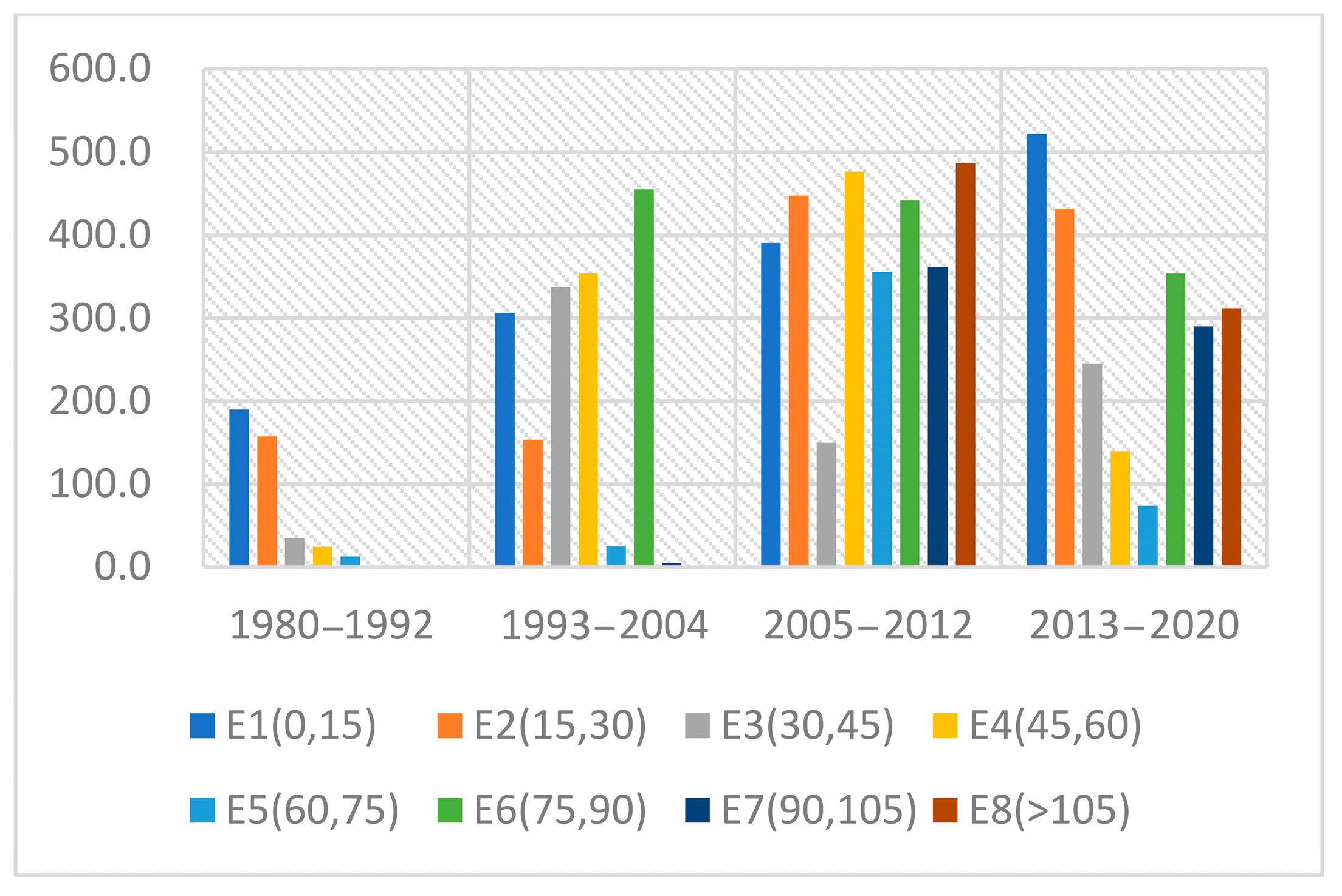
| Average Elevation (m) | E1 | E2 | E3 | E4 | E5 | E6 | E7 | E8 |
| 0–15 | 15–30 | 30–45 | 45–60 | 60–75 | 75–90 | 90–105 | >105 |
| Time period | First Period (1980–1992) | Second Period (1993–2004) | Third Period (2005–2012) | Fourth Period (2013–2020) |
|---|---|---|---|---|
| Area and Number | The total area (347.2 hectares) was limited, and the number of parks (13) was small. The constructed parks were primarily in the A1 and A2 categories. The number of parks built south of the Second Line (13) exceeded that of parks built north of it (9). | Both the total area (1030.4 hectares) and the number of parks (30) increased. The constructed parks were mainly in the A1, A2, A4, and A5 categories. The number of parks built north of the Second Line (54) exceeded that of parks built south of it (30). | The total area increased slightly (1067.9 hectares), and the number of parks continued to rise (43). Large parks (in the A7 and A8 categories) emerged, accounting for a relatively large proportion. The number of parks built north of the Second Line (103) exceeded that of parks built south of it (43). | The total area dropped markedly (531.6 hectares), but the number of parks rose further (60). The proportion of A7 and A8 category parks decreased overall compared with the preceding period, while the proportion of A1 and A2 category parks increased. More parks were built north of the Second Line (133) than south of it (60). |
| Slope and Elevation | Urban parks were primarily built in areas with gentle slopes (S3, S4, S5) and low elevations (E1, E2). | Urban parks were gradually built in areas with moderate slopes (S2, S3, S5, S6) and low-to-medium elevations (E1, E3, E4, E6). | Urban parks continued to be developed in areas with moderately high to high slopes (S5, S6, S7, S8) and mid-to-high elevations (E4, E5, E6, E7, E8), and parks began to appear in areas characterised by steep slopes and high elevations. | The proportion of parks constructed in areas with steep slopes and high elevations declined compared with the previous period, whereas the share of parks developed in areas with gentle slopes (S2, S3, S4) and low elevations (E1, E2, E3) increased significantly. |
| Land Use | Farmland constituted the primary source of land for park construction (63.2%), followed by forestland (22.8%). | The proportion of parks constructed on farmland declined (39.4%), whereas the proportion constructed on forestland increased (51.2%). | The proportion of parks constructed on farmland continued to decline (25.7%), while the proportion constructed on forestland continued to rise (65.1%). | The proportion of parks constructed on water areas (14.5%) increased significantly compared with the first three periods (7.1–8.5%). |
| Policy Drivers | With the implementation of the Regulations on the Guangdong Special Economic Zone, Shenzhen was officially established as a city. During this period, the policy framework of reform and opening-up remained relatively unstable, and urban development was limited in scale. Construction activities were primarily concentrated on the agricultural plains south of the Second Line, as designated by the government, resulting in substantial conversion and occupation of cultivated land. | Due to increasing scarcity of land resources south of the Second Line, urban expansion extended into the hilly areas north of the Second Line, resulting in increased occupation of forest land and a decline in the use of cultivated land. In addition, as the policy of reform and opening-up was further consolidated and the Interim Provisions on Rural Urbanisation in the Shenzhen Special Economic Zone were implemented, urban development continued to expand, and the average size of individual urban parks increased. | Urban expansion continued into the hilly areas north of the Second Line. With the implementation of the Shenzhen Basic Ecological Control Line Management Regulations, large mountainous areas were incorporated into the urban park system. Concurrently, the process of Pearl River Delta regional integration began, leading to extensive urban development and land reclamation along the eastern shore of the Pearl River Estuary. | Land resource constraints emerged on both sides of the Second Line. With the implementation of the Overall Plan for Land-Management System Reform of Shenzhen, the Pearl River Delta regional integration process entered a critical stage, and a large number of urban parks began to be developed on reclaimed land. |
| Western | Central | Eastern | |
|---|---|---|---|
| Favourable factors | Good conditions of land use, flat terrain, free from natural topographic threshold | Relatively concentrated development, prone to aggregated economy effect | Many types of shoreline, conducive to comprehensive development |
| Adverse factors | Relatively dispersed structure of the city, not conducive to the organisation of urban life | Many mountainous areas, difficult traffic organisation, and high construction costs of new transport facilities | Many mountainous areas and high development difficulty |
| Suitable Development Area (km2) | Utilised Area (km2) | Remaining Development Capacity (km2) | |
|---|---|---|---|
| Paddy field | 425.77 | 268.19 | 157.57 |
| Dry land | 133.13 | 96.56 | 36.56 |
| Forestland | 1119.99 | 541.84 | 578.16 |
| Pasture | 48.55 | 5.40 | 43.15 |
| Aquaculture water | 83.50 | 42.15 | 41.35 |
| Tidal flats | 40.22 | 10.21 | 30.01 |
Disclaimer/Publisher’s Note: The statements, opinions and data contained in all publications are solely those of the individual author(s) and contributor(s) and not of MDPI and/or the editor(s). MDPI and/or the editor(s) disclaim responsibility for any injury to people or property resulting from any ideas, methods, instructions or products referred to in the content. |
© 2026 by the authors. Licensee MDPI, Basel, Switzerland. This article is an open access article distributed under the terms and conditions of the Creative Commons Attribution (CC BY) license.
Share and Cite
Liu, X.; Sun, C.; Tian, Y.; Zheng, D. Natural Endowments and Planning Interventions: The Spatio-Temporal Evolution and Policy Drivers of Urban Park Distribution in Shenzhen. Sustainability 2026, 18, 5238. https://doi.org/10.3390/su18115238
Liu X, Sun C, Tian Y, Zheng D. Natural Endowments and Planning Interventions: The Spatio-Temporal Evolution and Policy Drivers of Urban Park Distribution in Shenzhen. Sustainability. 2026; 18(11):5238. https://doi.org/10.3390/su18115238
Chicago/Turabian StyleLiu, Xinyu, Cong Sun, Yu Tian, and Dianyuan Zheng. 2026. "Natural Endowments and Planning Interventions: The Spatio-Temporal Evolution and Policy Drivers of Urban Park Distribution in Shenzhen" Sustainability 18, no. 11: 5238. https://doi.org/10.3390/su18115238
APA StyleLiu, X., Sun, C., Tian, Y., & Zheng, D. (2026). Natural Endowments and Planning Interventions: The Spatio-Temporal Evolution and Policy Drivers of Urban Park Distribution in Shenzhen. Sustainability, 18(11), 5238. https://doi.org/10.3390/su18115238