Article

The Urban and Social Fabric of Heritage Nubian Villages in Egypt: A Comparative Study in Cultural Sustainability and Spatial Morphology

1
Department of Sociology, College of Humanities and Sciences, Ajman University, Ajman P.O. Box 346, United Arab Emirates
2
Humanities and Social Sciences Research Center (HSSRC), Ajman University, Ajman P.O. Box 346, United Arab Emirates
Sustainability 2026, 18(10), 4720; https://doi.org/10.3390/su18104720
Submission received: 16 February 2026 / Revised: 17 April 2026 / Accepted: 29 April 2026 / Published: 9 May 2026
(This article belongs to the Section Tourism, Culture, and Heritage)

Abstract

This study examines the relationship between spatial morphology and cultural sustainability in three heritage Nubian villages—Gharb Seheyl, Elephantine Island, and Heisa Island. Addressing the limitations of purely quantitative or qualitative approaches, it establishes a framework integrating three cultural dimensions: community structures, environmental adaptation, and vernacular building traditions. A Situational Research Method (SRM), inspired by metamodern theory, oscillates between spatial metrics and cultural interpretation. Findings reveal distinct morphological signatures: Gharb Seheyl’s linear form supports tourism-integrated preservation; Elephantine Island’s fragmented fabric reflects millennial continuity; Heisa Island’s compact morphology embodies resilience vernacular. SRM effectively delineates socio-cultural distinctions within the urban fabric, enhancing scientific rigor in heritage research and contributing to sustainable conservation of Nubian vernacular heritage.

1. Introduction

Vernacular architecture and traditional settlements constitute a unique cultural heritage, embodying centuries of human adaptation to local environments and social needs [1]. Across Egypt’s diverse landscape, traditional villages have evolved distinct spatial identities through generations of accumulated knowledge, responding to climatic conditions, topographical constraints, and cultural practices. These settlements represent more than physical fabric; they are living repositories of intangible heritage—social structures, customary practices, and communal values—that sustain community identity across generations [2].
Yet these heritage villages face unprecedented challenges in the contemporary era. Accelerating urbanization, infrastructure development, and rural modernization agendas have introduced homogenizing pressures that threaten the spatial distinctiveness of traditional settlements [3]. Throughout Egypt, once-distinct village morphologies increasingly give way to generic patterns that prioritize functional efficiency over cultural continuity. This transformation, while sometimes inevitable, exacts a significant cost: the gradual erosion of the cultural and social vitality embedded in traditional spatial arrangements [4].
The field of village morphology has made considerable strides in recent decades, developing sophisticated analytical tools for documenting and measuring settlement patterns. Spatial structure, ecological relationships, and morphological typologies have achieved theoretical maturity through technological applications [5]. Yet these quantitative approaches, however valuable, remain insufficient for addressing the fundamental question at the heart of heritage conservation: How can communities sustain cultural continuity amid unavoidable change?
Addressing this question requires moving beyond methodological binaries. Neither purely quantitative analysis nor purely qualitative description alone can capture the complex interplay between physical form and cultural meaning. The former risks reducing lived experience to abstract metrics; the latter may lack analytical precision. What is needed are frameworks capable of integrating these perspectives, oscillating between measurement and interpretation, between documentation and understanding. The methodology proposed in this study is shaped by metamodern theory, which transcends both the professed certainty of modernism and the deconstructive tendencies of postmodernism, balancing between digitization and humanities, outcomes and processes, and anchoring and emergence [6]. With a broad vision, this approach identifies the unique cultural heritage of traditional villages, revealing sustainable pathways for cultural heritage regeneration.
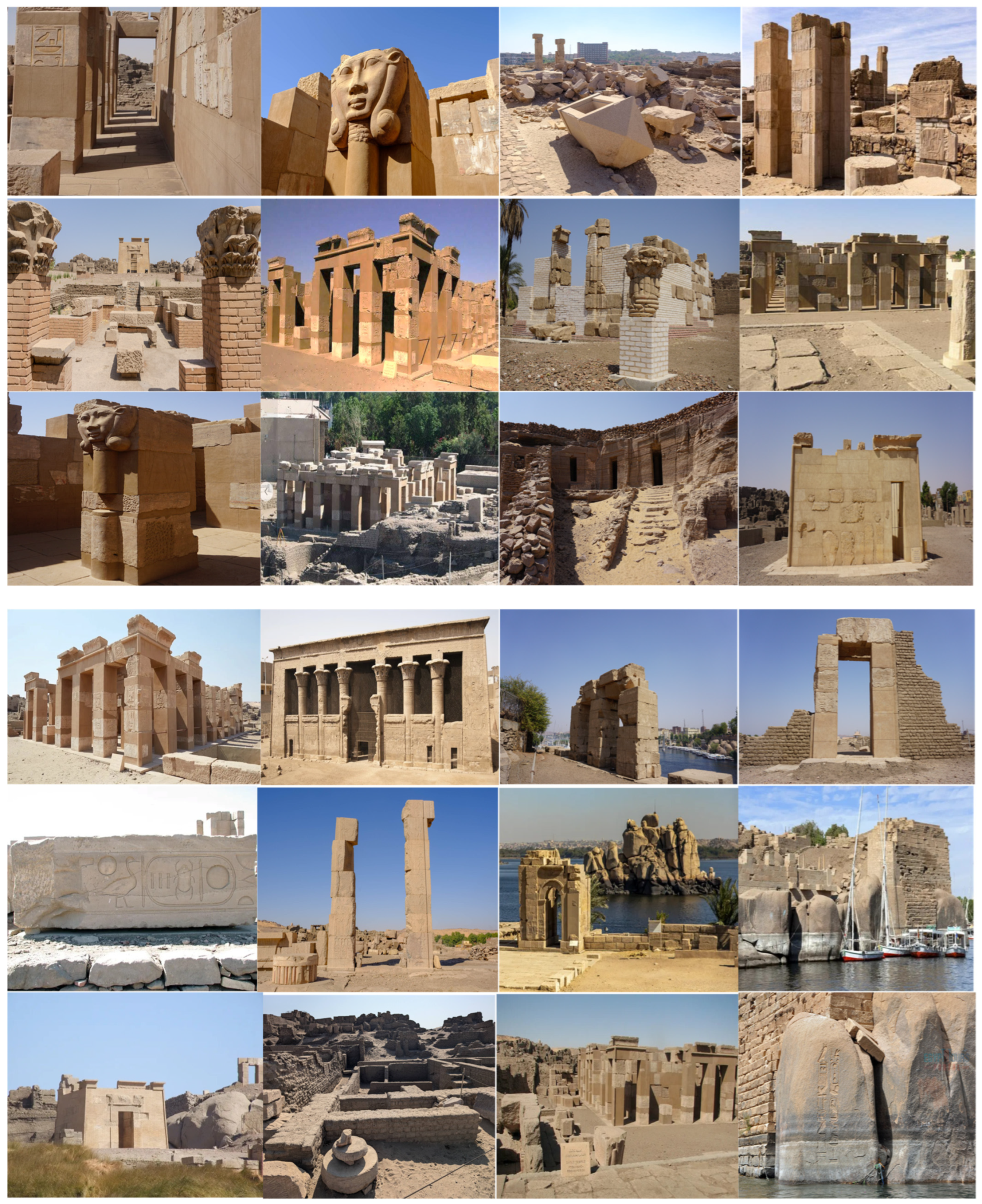
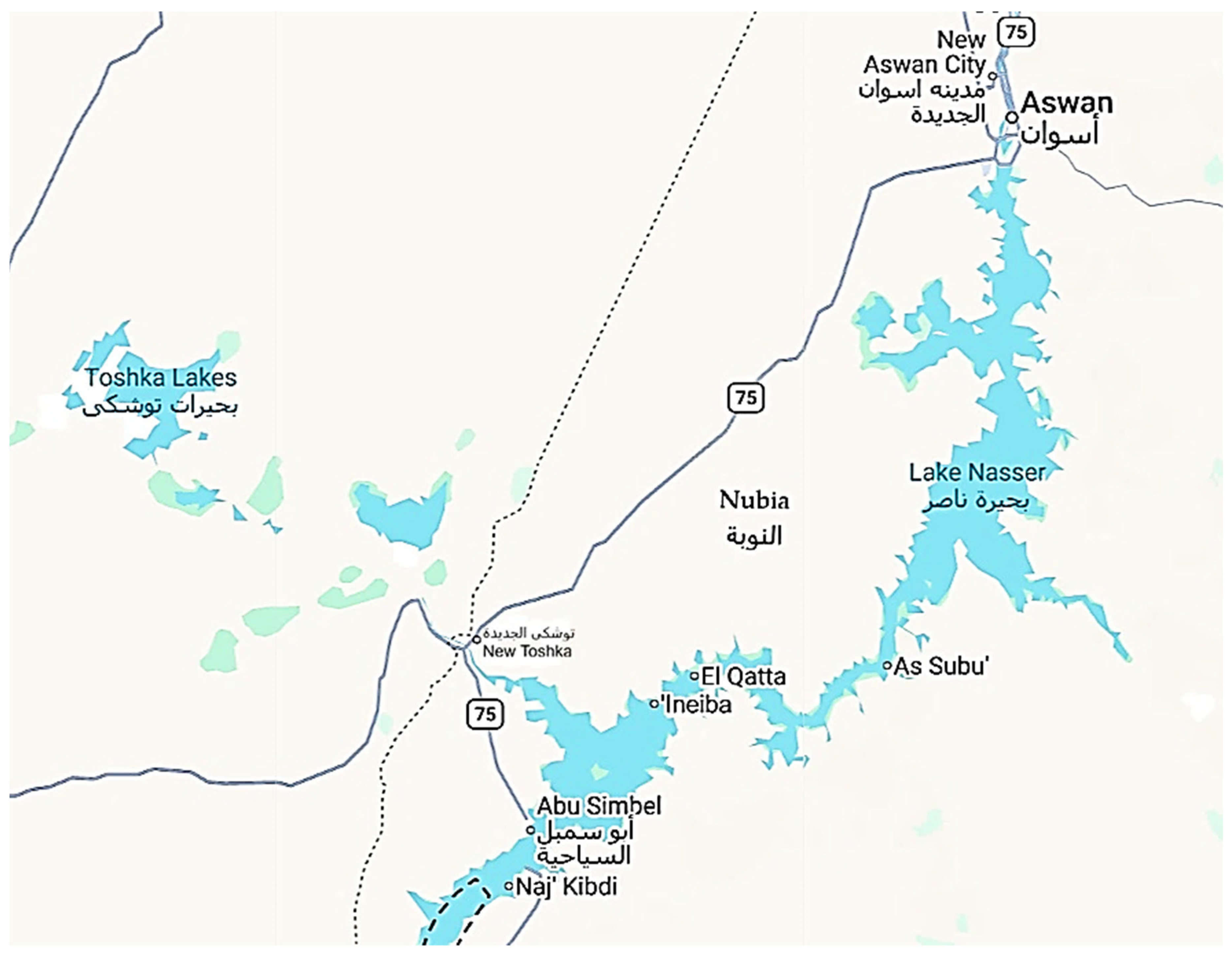
The Nubian region in southern Egypt presents an exceptional context for investigating these dynamics. Located along the Nile Valley south of Aswan, Nubia encompasses a unique cultural landscape shaped by millennia of civilization. Historically, the region has been a crossroads between Egypt and Africa, with successive influences from Pharaonic, Greco-Roman, and Islamic civilizations contributing to the spatial diversity of its traditional villages [7]. Figure 1 locates this region geographically.
The Nubian people possess a distinctive cultural identity, with their own language (Kenzi and Fadijja), traditions, and social structures that have persisted despite significant historical transformations. Nubian traditional villages embody spatial characteristics that reflect tangible environmental adaptations while incorporating the wisdom of vernacular building cultures [8].
The most profound disruption to Nubian heritage occurred in the 1960s with the construction of the Aswan High Dam, which led to the displacement of approximately 50,000 Nubians from 45 villages submerged beneath Lake Nasser. Resettled in new villages such as those around Kom Ombo and in the New Nubia region, Nubian communities demonstrated remarkable cultural resilience, transplanting their architectural traditions, social structures, and cultural practices to new environments [9].
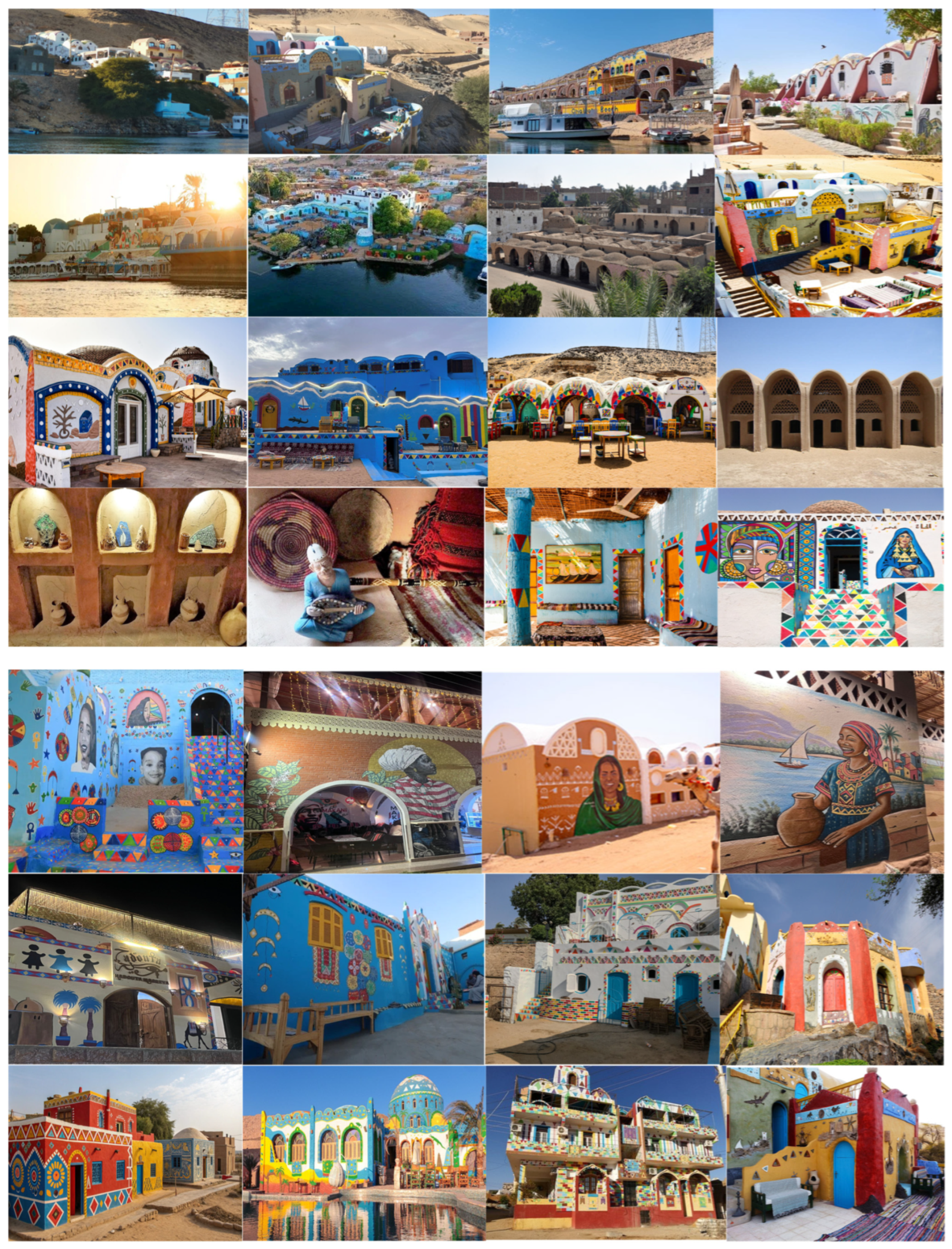
Heritage Nubian villages such as Gharb Seheyl, Elephantine Island, and Heisa Island exemplify this cultural continuity. These villages exhibit distinctive vernacular architecture characterized by mud-brick construction, vaulted and domed roofs (the Nubian vault technique), and elaborately decorated facades featuring geometric patterns, symbols, and scenes from daily life [10]. Local building traditions, responsive to climatic conditions and social structures, and functional and spatial layout principles were not only satisfied, but also a distinctive vernacular imagination and unique spatial character were brought about. It is argued that a systematic exploration of the relationship between the spatial forms of Nubian culture and their measurable characteristics is essential, aiming to uncover the sustainable development potential of village space in cultural heritage preservation [11].
Despite these methodological advancements, studies focusing on Nubian heritage villages remain limited, with research often emphasizing archeological aspects over living vernacular traditions. This study addresses this gap by applying an integrated analytical framework to heritage Nubian villages, examining the interplay between their unique urban fabric and enduring social structures within the context of cultural sustainability.
A growing body of scholarship has examined the relationship between residential space and culture, with contributions from researchers across diverse geographical contexts. Studies by Kwon & Kim (2019) in Korea [12], Al Husban (2021) in Jordan [13], Afon & Adebara (2022) in Nigeria [14], and Wang & Chiou (2020) in Taiwan [15] have collectively advanced the understanding of how cultural values shape domestic architecture and settlement patterns. Yet despite these valuable contributions, the specific relevance of cultural dimensions to the village spatial environment remains underexplored, with much of the existing work remaining at a theoretical level rather than developing empirically grounded analytical frameworks.
Nevertheless, a persistent gap remains: the absence of systematic frameworks for analyzing how specific cultural dimensions manifest in measurable spatial characteristics. While scholars have demonstrated that culture matters, the question of precisely how cultural values translate into spatial configurations—and how these configurations evolve over time—has received insufficient attention. This study addresses this gap by proposing an analytical framework grounded in three cultural dimensions specifically relevant to the Nubian context.
However, the classification of village spatial morphologies presents significant challenges within cultural research contexts. Previous classification standards were primarily based on tangible forms, whereas culture constitutes an intangible factor [16], shaped by elements such as local environment, social practices, belief systems, and vernacular consciousness. The methodology employed for culture-led village morphology analysis requires further exploration in sustainable heritage conservation. Generally, research on traditional village forms is extensive, focusing on historical processes and social environments that shape village morphology [17]. However, these studies include limited analysis of intangible morphological elements, the logical relationships between different scales of traditional villages, and the interactions between spatial morphology and culture [18].
In the context of Nubian heritage villages, these research gaps are particularly pronounced. Scholarly attention to Nubian heritage has predominantly focused on archeological expeditions, monumental architecture, and the salvage campaigns conducted during the construction of the Aswan High Dam in the 1960s [19]. The International Campaign to Save the Monuments of Nubia, launched by UNESCO, successfully documented and relocated numerous temples, yet this effort concentrated on Pharaonic structures rather than vernacular settlements [20]. Anthropological studies have documented Nubian social organization, language, and customs, while architectural historians have examined the distinctive features of Nubian domestic architecture, including vaulted mud-brick construction and courtyard layouts [21]. However, these disciplinary threads remain largely disconnected, with limited integration of spatial analysis, cultural dimensions, and sustainability perspectives. The relationship between the physical fabric of Nubian villages and the intangible social practices that sustain community identity has received minimal scholarly attention [22].
In this paper, limitations in cultural research on village spatial morphology are intended to be addressed from a metamodern perspective, with a focus on the culturally distinctive Nubian region in southern Egypt as a representative case. A cultural spatial morphology framework is constructed by analyzing the Nubian cultural context to determine the contemporary activation and sustainable utilization of heritage villages. In this research, a Situational Research Method (SRM) is proposed, combining traditional village spatial culture and digital analysis to explore the dynamic relationships and characteristics of village forms across three selected Nubian villages: Gharb Seheyl, Elephantine Island, and Heisa Island.
The main contributions of this study are as follows:
(1) We expand the village sample across the Nubian cultural region while integrating regional diversity and cultural contexts, proposing a framework that classifies spatial morphologies for heritage conservation, enabling sustainable preservation of Nubian vernacular heritage that has been largely overlooked in previous scholarship.
(2) The methodology proposed in this study is shaped by metamodern theory, as articulated by Vermeulen and van den Akker [23]. This theory transcends both the professed certainty of modernism and the deconstructive tendencies of postmodernism. It balances between digitization and the humanities, outcomes and processes, and anchoring and emergence. Based on this theoretical foundation, a Situational Research Method (SRM) is proposed. This method integrates digital quantification and cultural morphology to transcend the humanities–quantitative classification binary in heritage conservation. It is applied to the comparative analysis of three distinct Nubian village typologies.
(3) Adopting a comparative perspective, we clarify key indices and attributes of Nubian vernacular heritage and establish a heritage database for Nubian villages to promote precise conservation methods that balance cultural authenticity with sustainable development, while offering insights applicable to other heritage village contexts.

2. Theoretical Framework

2.1. Evolving Approaches to Village Morphology

The study of traditional settlement patterns has witnessed significant methodological development over recent decades. Researchers have increasingly employed quantitative tools to measure, classify, and analyze the physical characteristics of villages, seeking to identify recurring patterns and establish typologies that facilitate comparative analysis [24]. These computational approaches have proven valuable for documenting spatial heritage across diverse geographical contexts, enabling researchers to process large datasets and identify morphological regularities that might escape purely observational methods [25]. However, a persistent challenge confronts this line of inquiry: the reduction in complex cultural landscapes to measurable parameters risks overlooking the intangible meanings, social practices, and symbolic dimensions that constitute the lived experience of village communities [26]. Cultural factors resist easy quantification, demanding analytical frameworks that can accommodate both the measurable and the meaningful, the physical and the perceptual.
This challenge becomes particularly acute when examining regions distinguished by rich cultural heritage, where settlement patterns embody centuries of accumulated knowledge, belief systems, and social organization. In such contexts, purely metric approaches capture only the outer shell of village form while missing the cultural logic that animates it. The need therefore arises for methodological frameworks capable of oscillating between quantitative precision and qualitative understanding, between the generalizable and the particular, between what can be counted and what must be interpreted [27].
Currently, research on the spatial morphology of traditional villages has shifted towards systematic and digital approaches. Scholars have conducted macro-analyses of building typologies, historical settlement patterns, cultural geography, and morphological genes across various village contexts, progressing from local resource documentation to digital modeling [28]. Bibliographic analysis reveals distinct evolutionary stages in traditional village spatial morphology research. Prior to 2000, research focused on descriptive studies of village forms based on field investigations, involving extensive surveys and data collection across diverse village types. From 2000 to 2012, theories concerning village spatial morphology from Eastern and Western perspectives converged, prompting scholars to focus on quantitative analyses of village spatial morphology prototypes. Since 2012, GIS and digital technologies have been utilized to assist in identifying village spatial morphology with the exploration of classification systems. Analyses have been conducted from various perspectives, such as topography, climate, and functionality [29]. Since 2020, the field has entered a stage of diversified exploration, employing methods such as three-dimensional digitization, spatial quantitative analysis, and morphological mapping to advance towards interdisciplinary integration. Concurrently, contemporary village applications are being re-examined from multiple perspectives, including social structure, vernacular culture, and spatial habitat [30].
The field has evolved considerably in recent decades, expanding from static morphological descriptions toward dynamic, holistic approaches that consider settlements as living systems rather than fixed forms. Research precision has improved across multiple integrated dimensions, encompassing the natural environment, family and social structures, and vernacular building traditions [31]. This methodological maturation has enabled more nuanced understandings of how villages function as complex socio-spatial entities. These theoretical developments are not limited to specific geographical contexts. Cross-cultural studies have significantly contributed to this understanding: in the Middle East, Al Husban (2021) [13] examined the impact of cultural beliefs on spatial organization and privacy in Jordanian housing; in Africa, Afon and Adebara (2022) [14] explored the socio-cultural utilization of open spaces in traditional residential neighborhoods in Nigeria; in East Asia beyond China, Kwon and Kim (2019) [12] analyzed the characteristics of residential space in response to changing lifestyles in South Korea; and in Europe, the foundational typological studies by Caniggia and Maffei (1993) established enduring principles for interpreting building typologies across historical contexts [32]. This body of international research demonstrates that the methodological challenges of integrating spatial analysis with cultural understanding are universal, while their specific manifestations are necessarily context-dependent.

2.2. Metamodern Theory as Conceptual Foundation

The metamodern sensibility offers precisely such an oscillatory framework. Emerging from contemporary cultural theory, metamodernism describes a mode of thought and practice that moves beyond both the certainties of modernism and the skeptical deconstruction of postmodernism [33]. Rather than choosing between opposed positions, metamodern thinking consciously oscillates between them, recognizing that complex phenomena often require multiple, seemingly contradictory perspectives. This oscillatory movement—between hope and melancholy, sincerity and irony, construction and deconstruction—characterizes the metamodern approach to knowledge and practice [34].
For heritage studies, metamodern theory opens productive possibilities. It acknowledges the value of scientific rigor and digital documentation while insisting on the irreplaceable role of humanistic interpretation. It recognizes that villages are simultaneously material places and cultural constructs, physical settlements and imagined communities. This dual nature—the village as measurable object and meaningful subject—demands analytical approaches that can move fluidly between these dimensions without reducing one to the other [35].

2.3. Core Concepts: Anchoring, Oscillation, and Situational Analysis

Within this metamodern framework, several key concepts guide our investigation of Nubian heritage villages. The first is anchoring—the idea that certain spatial elements provide stability and continuity across time, grounding community identity in the physical environment. These anchors may include architectural forms that persist across generations, spatial arrangements that organize social life, or material symbols that carry cultural memory [36]. In the Nubian context, such anchors might include the distinctive domed roofs that silhouette the skyline, the courtyard configurations that structure domestic life, or the “mustabah” benches that facilitate community gathering. These elements anchor cultural practice in physical form, providing tangible reference points for identity and belonging.
Yet villages are not static. They evolve, adapt, and transform in response to changing circumstances—economic shifts, environmental pressures, social transformations. This brings us to the second concept: understanding how anchored forms undergo change while maintaining continuity. The dynamic between stability and transformation lies at the heart of cultural sustainability. Communities must negotiate between preserving heritage and accommodating change, between honoring tradition and embracing innovation. This negotiation occurs not through simple opposition but through complex processes of adaptation, reinterpretation, and selective preservation.
The third concept addresses the mutual constitution of material form and cultural meaning. Villages are not containers within which culture happens; rather, spatial forms and cultural practices continuously shape one another. The layout of pathways influences social encounters; the configuration of houses shapes family relations; the arrangement of public spaces enables collective rituals. Conversely, cultural values, beliefs, and social structures find expression in how space is organized, used, and modified over time [37]. This reciprocal relationship—what we might call the spatial-cultural dialectic—requires analytical methods sensitive to both directions of influence.

2.4. Toward a Situational Research Method (SRM)

These theoretical considerations converge in the Situational Research Method (SRM) proposed in this study. The SRM draws inspiration from the situational analysis approach pioneered by Max Gluckman (1940) in anthropology [38] and further developed by Adele Clarke (2005) in qualitative social research [39]. However, SRM adapts and extends these traditions to operationalize metamodern principles for the investigation of heritage villages. Rather than imposing a single analytical lens, SRM moves situationally between different modes of inquiry, selecting the most appropriate tools for each research question while remaining aware of their limitations. It oscillates between digital quantification and ethnographic understanding, between spatial analysis and cultural interpretation, between documentation of what exists and exploration of what it means.
For the three Nubian villages examined in this study—Gharb Seheyl, Elephantine Island, and Heisa Island—SRM enables a comparative analysis that respects their distinctive characters while identifying shared patterns. It allows us to examine how similar cultural traditions manifest differently across varied geographical and historical circumstances and how each village negotiates the universal challenge of sustaining heritage amid change. By moving situationally between scales of analysis—from individual houses to village layouts to regional patterns—and between modes of understanding—from measured description to interpreted meaning—SRM seeks to capture the full complexity of these living heritage landscapes [40,41].
This framework thus positions the study at the intersection of multiple intellectual trajectories: the quantitative tradition in morphological research, the interpretive tradition in cultural studies, and the integrative aspirations of metamodern thought. From this intersection, we aim to develop insights that are both rigorously documented and richly understood, contributing to both scholarly knowledge and practical heritage conservation.

3. Materials and Methods

3.1. Study Location

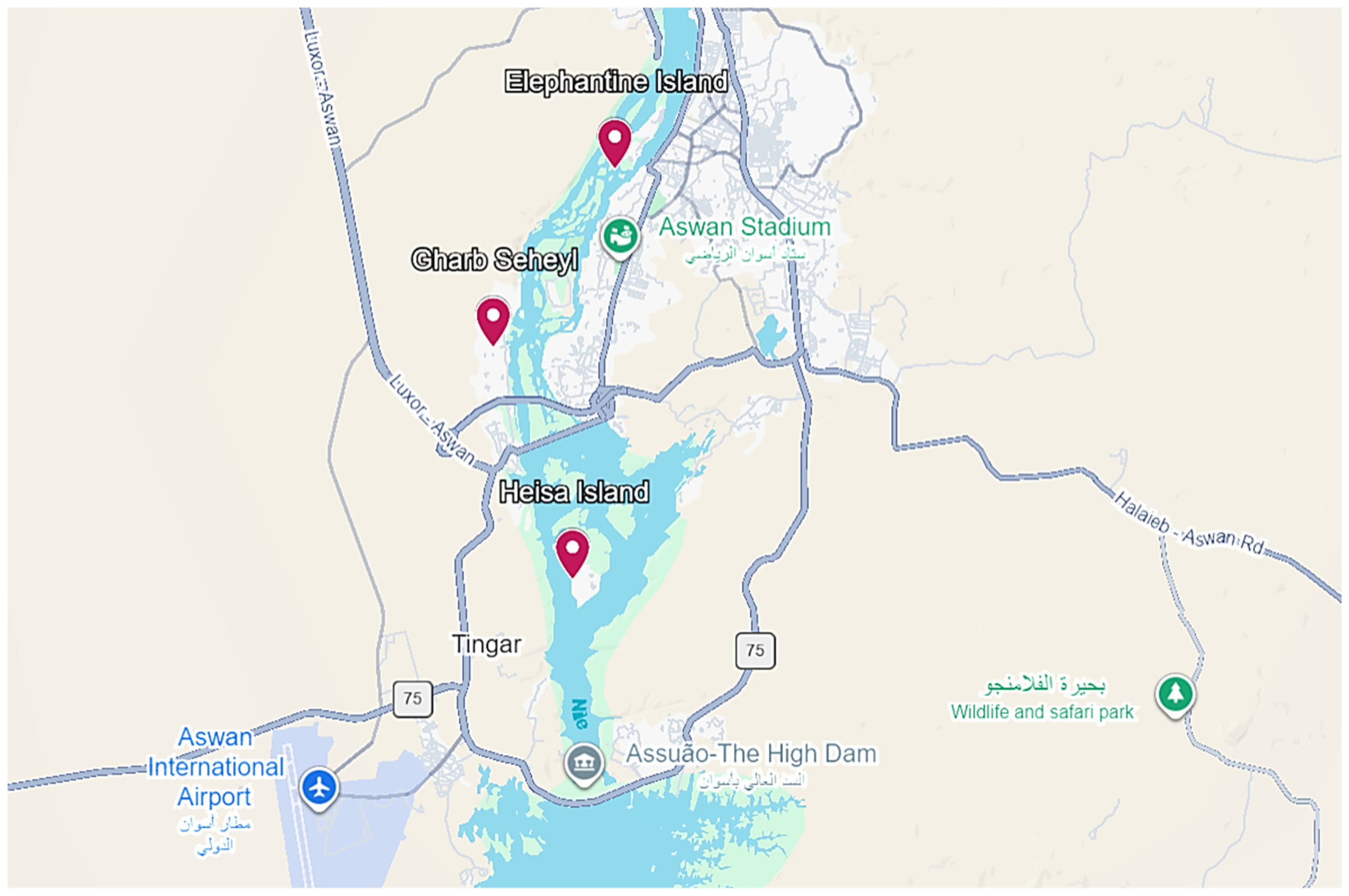
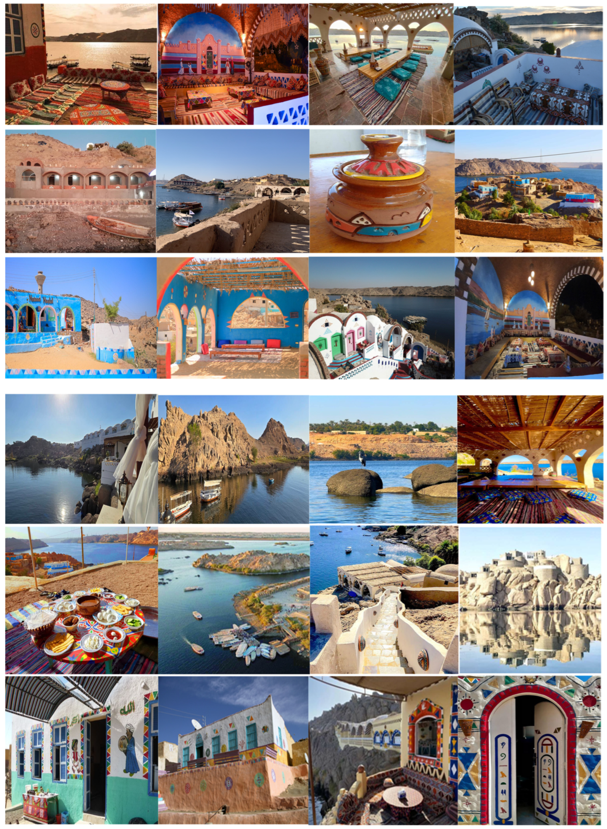
This study focuses on three heritage Nubian villages located in southern Egypt, within the Nile Valley south of Aswan. These villages—Gharb Seheyl, Elephantine Island, and Heisa Island—were selected as representative cases that embody the distinctive cultural and spatial characteristics of Nubian vernacular heritage (Figure 2).
The selection criteria included: (1) authentic preservation of traditional Nubian architecture; (2) continuity of social structures and cultural practices; (3) geographical and typological diversity; and (4) accessibility for field documentation. The following are the geographical, architectural, and cultural characteristics of three heritage Nubian villages in Table 1 and Figure 3, Figure 4 and Figure 5:
Historical Evolution of the Three Villages Before and After the Aswan High Dam:
Before the 1960s, all three villages relied on the annual Nile flood for agriculture and had their settlements close to the riverbank. Their traditional mud-brick architecture was adapted to the seasonal flood cycle [42,43].
The construction of the Aswan High Dam (1960–1970) fundamentally altered the landscape and each village’s trajectory [44,45]:
  • Gharb Seheyl: Located on the mainland’s west bank, it was not directly flooded but experienced the end of the natural flood cycle. This forced a shift from traditional flood-recession agriculture to tourism and crafts, leading to its recent recognition as a UNWTO Best Tourism Village in 2024. The village’s character was preserved because it remained in its original location.
  • Elephantine Island: Also not evacuated, the dam transformed its relationship with the river. The stable water level allowed for year-round agriculture and protected archeological sites from seasonal flooding. The existing Nubian settlements (Siou and Koti) remained intact, and their inhabitants continued millennia-old agricultural and artistic traditions without forced relocation.
  • Heisa Island: This village presents the most dramatic case of resilience. Unlike the others, it was one of the few Nubian settlements partially flooded by the rising reservoir. Approximately one-third of the original village was submerged. The remaining inhabitants made a collective decision to relocate their homes to the highest ground on the island, preserving their social cohesion and traditional “mustabah” gathering spaces. This voluntary relocation, without forced displacement by the government, is unique among Nubian villages and explains their exceptionally strong cultural continuity and pride.

3.2. Data Collection and Sources

Data for this study were collected from multiple sources to ensure comprehensive documentation of both physical and cultural dimensions of the selected villages. The data collection process integrated spatial documentation techniques with community-based methods, involving three phases: (1) pre-fieldwork preparation, including satellite imagery analysis and literature review; (2) intensive field documentation combining measurement, photography, and community engagement; and (3) post-fieldwork data processing, GIS digitization, and database construction.

3.2.1. Primary Data Collection Sources

On-site field surveys and architectural documentation: Systematic architectural surveys were conducted across all three villages, documenting building footprints, heights, construction materials, and architectural features. Measurements were recorded using laser distance measurers and manual tape measures, with coordinates captured via handheld GPS devices (Garmin GPSMAP 64s, Garmin Ltd., Schaffhausen, Switzerland, accuracy ±3 m).
High-resolution satellite imagery: Satellite imagery from Google Earth (Maxar Technologies, Maxar Technologies Inc., Westminster, CO, USA, 2024–2025) and Bing Maps was accessed to establish base maps and verify spatial configurations. Images with resolution ≤ 0.5 m/pixel were selected to enable detailed digitization of building footprints and circulation networks.
Photographic documentation: Photographs were documenting architectural features, spatial configurations, facade decorations, community spaces, and daily activities. The process was systematic to ensure comprehensive coverage of each village’s built environment and social spaces (Table 2).
Semi-structured interviews with local residents and community leaders: A total of 42 semi-structured interviews were conducted across the three villages between January and March 2025. Table 3 presents the distribution and characteristics of interview participants.
Sampling method: Due to the closely knit nature of Nubian communities and cultural sensitivities regarding outsiders, a convenience sampling approach combined with snowball sampling was employed. Initial contacts were established through community leaders and local ‘mu’arifs’ (community introducers) who facilitated access to residents. From these initial participants, additional respondents were identified through referrals within kinship networks. While this non-probability sampling limits statistical generalizability, it was essential for gaining trust and accessing authentic community perspectives in these culturally conservative settings.
Recruitment and response rate: A total of 58 individuals were approached for participation across the three villages. Of these, 42 agreed to participate, while 16 declined, yielding a response rate of 72.4%. Primary reasons for refusal included time constraints (n = 8), privacy concerns (n = 5), and disinterest in the research topic (n = 3). No financial incentives were offered to participants; participation was entirely voluntary, motivated by community interest in documenting Nubian heritage.
Interview protocol: Interviews were conducted in Arabic (the native language of both researchers and participants) at locations chosen by participants—typically in their homes, at “mustabah” benches, or in community gathering spaces. Each interview followed a flexible guide covering: (1) family history and village settlement patterns; (2) traditional building practices and knowledge transmission; (3) use of community spaces and gathering traditions; (4) perceptions of cultural change and continuity; and (5) experiences with tourism or development. Interviews were audio-recorded with participants’ verbal consent, and supplementary notes were taken during sessions. The average interview duration was 62 min (range: 35–110 min). Audio recordings were transcribed verbatim in Arabic, with key passages translated to English for analysis.
Observation of social practices and community gatherings: Systematic observation was conducted using participant observation techniques over 45 days of fieldwork distributed across the three villages, as shown in Table 4.
Observation methodology: Observation sessions ranged from 1 to 4 h and focused on: (1) spatial usage patterns of public and semi-public spaces; (2) social interactions and gathering dynamics; (3) gender and age patterns in space occupation; (4) daily rhythms and temporal variations in space use; and (5) relationships between built form and social practices. Observations were documented through field notes recorded during or immediately after each session, complemented by photographic documentation (over 600 observation-specific photographs) and occasional sketch mapping of space usage patterns. In all cases, researchers maintained a visible presence and explained their purpose to community members present.
Positionality and ethical considerations: All participants were informed about the research purpose, the voluntary nature of participation, and their right to withdraw at any time. Informed consent was obtained from all interview participants and for all photography depicting identifiable individuals. Community leaders were consulted prior to fieldwork to explain the research objectives and obtain community-level acceptance. All personal identifiers have been removed from stored data, and pseudonyms are used in any reporting of individual perspectives.

3.2.2. Secondary Data Collection Sources

Secondary data sources provided historical context and validation for primary observations:
  • Official records from the Ministry of Tourism and Antiquities, Egypt: Accessed through official requests, providing documentation of registered heritage buildings and previous conservation interventions.
  • UNESCO documentation: Reports and archival materials related to Nubian heritage and the International Campaign to Save the Monuments of Nubia (1960–1980), accessed through UNESCO online archives and Cairo office documentation.
  • Historical maps and archival materials: Colonial-era maps (1900–1950) from the Egyptian Geographical Society archives and pre-resettlement photographs of Nubian villages obtained from personal collections and published sources.
  • Published anthropological and architectural studies: Comprehensive review of academic literature on Nubian settlements, including seminal works by Egyptian and international scholars.
  • Local municipality records and village documentation: Demographic data, building permit records, and community development plans obtained from Aswan Governorate and local administrative offices.

3.2.3. Common Method Variance Assessment

To address potential concerns regarding common method variance (CMV) in data collection—particularly given the reliance on self-report measures in interviews and observational interpretations—several procedural and statistical remedies were employed:
Procedural remedies: (1) Methodological triangulation through integration of multiple data sources (spatial measurements, observations, interviews, archival documents) reduces the risk of method-specific bias; (2) Temporal separation of data collection activities, with spatial documentation conducted independently from interviews to minimize artificial correlations; (3) Protection of respondent anonymity to reduce social desirability bias in interview responses; (4) Careful question phrasing in interviews to avoid leading questions and ambiguous terminology; (5) Multiple observers involved in fieldwork to balance individual observer biases.
Statistical assessment: Although the study’s primary analytical approach is qualitative-interpretive, the quantitative morphological indices were examined for potential bias. Harman’s single-factor test was selected because it is a widely recognized and straightforward method for detecting common method variance (CMV) in quantitative data [40]. This test is particularly suitable when the study design involves multiple variables measured from the same source, as it helps determine whether a single factor accounts for the majority of variance among variables, which would indicate potential bias. The test was conducted on the spatial variables included in the morphological analysis. Results indicated that a single morphological factor—representing the shared variance among the three spatial indices (Shape Index, Compactness Coefficient, and Fractal Dimension Index) due to common measurement methods (GIS, field surveys, and photography)—accounted for 31.7% of the total variance among variables, substantially below the recommended threshold of 50%, suggesting that common method variance does not pose a significant threat to the validity of the quantitative findings. Additionally, correlation patterns among morphological indices were consistent with theoretical expectations and field observations. For example, the expected positive correlation between boundary complexity (Shape Index) and internal fragmentation (Fractal Dimension Index) was confirmed both statistically and through direct observation: Gharb Seheyl’s irregular boundary corresponded with its intricate internal alleyways, while Heisa Island’s regular shape aligned with simpler internal patterns. These concordances between quantitative analysis and qualitative field observations provide further confidence in data quality. The combination of procedural safeguards and statistical testing supports the validity and reliability of the integrated dataset for addressing the research questions.

3.3. Methods

This research employs an integrated methodological framework that combines spatial analysis with cultural interpretation, guided by metamodern theory. The framework consists of four interconnected phases: (1) construction of a comprehensive spatial database for the three villages; (2) morphological analysis and classification using GIS tools; (3) digitalization of morphological indices; and (4) situational analysis integrating quantitative metrics with cultural context through the Situational Research Method (SRM).

3.3.1. Cultural-Spatial Analytical Framework

Aldo Rossi, who was both a practicing architect and architectural theorist, emphasized in his seminal work The Architecture of the City (1982/1966) [46] that architectural and spatial analysis should not isolate forms from their historical and cultural contexts but rather integrate them within the broader framework of urban organization, civilization, and cultural meaning. Following this principle, this study approaches spatial morphology not as mere geometric categorization but as an exploration of the cultural logic embedded in Nubian settlement patterns.
For Nubian traditional villages, spatial morphology has been shaped by three interconnected cultural dimensions that emerged from the literature review and preliminary field observations (Table 5):
Dimension 1: Cohesive community and kinship structures. Nubian society is organized around extended family networks and clan affiliations, with social cohesion expressed spatially through clustered housing patterns, shared courtyards, and communal gathering spaces such as the “mustabah”—raised mud-brick benches attached to exterior walls that facilitate daily social interaction. This dimension manifests in spatial configurations that balance privacy for individual families with opportunities for community encounter.
Dimension 2: Adaptive environmental and ecological practices. Situated along the Nile in a challenging climatic environment, Nubian villages demonstrate sophisticated adaptation to their surroundings. Spatial organization responds to solar orientation, prevailing winds, and seasonal flooding patterns. The relationship between settlement and river—whether direct waterfront access, terraced arrangements on islands, or elevated positions on higher ground—reflects generations of accumulated environmental knowledge.
Dimension 3: Vernacular building cultures and spatial traditions. Nubian architectural traditions encompass distinctive construction techniques (the Nubian vault, domed roofs), material practices (mud-brick production and maintenance), and decorative traditions (geometric patterns, symbolic motifs, colorful facades). These traditions are not merely esthetic but embody cultural values, cosmological understandings, and social meanings transmitted across generations.

3.3.2. Digitalization of Morphological Indices

Spatial data collected through field surveys and photography were processed using Geographic Information Systems (ArcGIS 10.8) to generate accurate base maps and extract quantitative morphological indices for each village. Building footprints, circulation networks, open spaces, and village boundaries were digitized at high resolution, creating a comprehensive spatial database.
Following established approaches in village morphology research, three quantitative indices were calculated to characterize spatial patterns:
(1) Shape Index (S): Represents the complexity of village boundary morphology.
S = P/(2√(πA)) × λ
where
P = perimeter of village boundary
A = area of village
λ = length-width ratio coefficient
Higher S values indicate more complex boundary configurations, reflecting adaptation to topographical constraints or organic growth patterns.
(2) Compactness Coefficient (θ): Represents the degree of spatial aggregation and expansion potential.
θ = A/Ar
where
A = area of village
Ar = area of minimum bounding rectangle
Values range from 0 to 1, with higher values indicating more compact, regularly shaped settlements, and lower values suggesting dispersed or irregular configurations.
(3) Fractal Dimension Index (S2): Represents the complexity of internal spatial structure.
S2 = 2 ln(P/4)/ln(A)
where
P = perimeter of village boundary
A = area of village
S2 values typically range from 1.0 to 2.0, with higher values indicating greater fragmentation of the built fabric and more complex internal spatial organization.
These indices were applied to the three selected villages to enable quantitative comparison of their morphological characteristics. The calculated values are presented and analyzed in the Section 4.

3.3.3. The Situational Research Method (SRM)

The Situational Research Method (SRM), guided by metamodern theory, constitutes the core analytical approach of this study. SRM situates spatial forms within their appropriate cultural contexts, examining the dynamic relationships between physical patterns and social meanings. Rather than treating quantitative metrics and qualitative understanding as separate enterprises, SRM oscillates between them, recognizing that both perspectives are necessary for comprehending the full complexity of heritage villages.
The application of SRM in this study involves four analytical movements:
First movement: Morphological documentation. Quantitative spatial analysis establishes baseline measurements for each village, documenting patterns of layout, density, configuration, and architectural typology. This movement produces comparable datasets across the three cases, enabling systematic comparison.
Second movement: Cultural contextualization. The quantitative patterns identified are interpreted within their cultural contexts, drawing on ethnographic observation, community interviews, and historical knowledge. This movement examines the cultural logic that explains these spatial patterns, how residents understand and experience their built environment, and what meanings are attached to particular spaces and forms.
Third movement: Oscillatory analysis. Moving iteratively between quantitative patterns and cultural interpretations, this phase examines how spatial forms both shape and are shaped by social practices, cultural values, and historical processes. Particular attention is paid to moments where quantitative patterns challenge cultural expectations or where cultural knowledge suggests refinements to spatial analysis.
Fourth movement: Comparative synthesis. Findings from the three villages are compared to identify both shared Nubian patterns and distinctive local variations. This comparative perspective reveals how common cultural traditions manifest differently across varied geographical and historical circumstances, illuminating processes of cultural adaptation and resilience.
To ensure analytical rigor, this study employs several validation strategies:
Triangulation across multiple data sources (spatial documentation, observation, interviews, archival materials).
Member checking through community presentations to verify interpretations.
Peer debriefing with scholars familiar with Nubian heritage was chosen because peers provide an independent, critical assessment that helps identify biases and blind spots that the author may overlook. Their expertise ensures that interpretations are culturally and methodologically sound.
Systematic documentation of analytical procedures to ensure transparency.
This methodological framework enables the study to address the research gap identified earlier: the disconnection between spatial analysis, cultural understanding, and sustainability perspectives in studies of Nubian heritage. By integrating these dimensions through SRM, the research aims to generate insights that are both rigorously documented and richly contextualized, contributing to both scholarly knowledge and practical heritage conservation.

4. Results

This section presents the findings of the comparative morphological analysis conducted on the three selected heritage Nubian villages: Gharb Seheyl, Elephantine Island, and Heisa Island. The results are structured to first present the quantitative morphological indices, followed by a detailed comparative analysis of each index in relation to the villages’ geographical and cultural contexts. Finally, the spatial expressions of the three cultural dimensions are synthesized.

4.1. Morphological Indices Analysis

The three quantitative morphological indices—Shape Index (S), Compactness Coefficient (θ), and Fractal Dimension Index (S2)—were calculated for each village based on field survey data, high-resolution satellite imagery, and GIS analysis. The complete results are presented in Table 6.
The results reveal distinct morphological characteristics for each village, reflecting their unique geographical contexts, historical development patterns, and adaptive strategies. Gharb Seheyl exhibits the highest Shape Index, indicating the most complex boundary configuration. Heisa Island demonstrates the highest Compactness Coefficient, signifying a dense and aggregated settlement form, while Elephantine Island shows the greatest internal spatial fragmentation, as indicated by its Fractal Dimension Index.

4.2. Comparative Analysis of Village Morphological Complexity

4.2.1. Shape Index (S) Analysis

The Shape Index values reveal varying levels of morphological complexity across the three villages. As established, higher S values indicate more complex boundary configurations, reflecting adaptation to topographical constraints or organic growth patterns (Table 7).

4.2.2. Compactness Coefficient (θ) Analysis

The Compactness Coefficient indicates the degree of spatial aggregation and expansion potential. Higher values (closer to 1) suggest more compact, regularly shaped settlements, while lower values indicate dispersed or irregular configurations with constrained expansion potential (Table 8).

4.2.3. Fractal Dimension Index (S2) Analysis

The Fractal Dimension Index reflects the complexity of internal spatial structure and the level of fragmentation of the built fabric and public spaces. Higher values indicate greater fragmentation and more complex internal organization (Table 9).

4.3. Cultural Dimensions and Spatial Expressions

The three cultural dimensions identified in the analytical framework manifest distinctly in each village’s spatial configuration, as documented through field observations.

4.3.1. Community Organization

Field observations reveal distinct spatial expressions of community and kinship structures across the three villages. Clan-based social organization is reflected in clustered housing patterns, the distribution of “mustabah” benches, and the arrangement of communal spaces. Table 10 summarizes these spatial expressions and their key indicators as documented during fieldwork.

4.3.2. Environmental Adaptation

Each village demonstrates unique adaptive strategies to its geographical context. Linear riverine orientation, terraced island slopes, and collective relocation to higher ground represent distinct spatial responses to environmental challenges. Table 11 presents the adaptation strategies and their spatial manifestations across the three villages.

4.3.3. Building Traditions

Vernacular building traditions vary across the three villages while sharing common Nubian construction techniques. From the colorful decorated facades of Gharb Seheyl to the pure, unadorned vaults of Heisa Island, each village expresses its architectural heritage uniquely. Table 12 details the architectural features and construction techniques observed in each village.

4.3.4. Community Voices: Living Heritage Through Residents’ Words

While spatial analysis quantifies patterns and forms, the voices of community members reveal the meanings embedded in the built environment. The following quotes, drawn from semi-structured interviews across the three villages, provide direct insight into how residents perceive, experience, and value their spatial heritage. These voices are organized thematically to reflect the intimate connection between space, culture, and identity in Nubian heritage villages.
The “Mustabah” as Social Heartbeat
Across all three villages, residents consistently identified the “mustabah” benches as the most significant social space. These simple mud-brick structures are described not as architectural features but as living institutions that sustain community cohesion:
“Every evening, the men gather on the mustabah. This is how we know everything about our village—who is born, who is married, who needs help. Without the mustabah, we would be strangers to each other”.
(Male resident, Gharb Seheyl, 52 years)
“The mustabah here is not just a bench. It is our council, our court, our family. Every problem is solved here. Every joy is shared here. When someone returns from travel, the first place they go is not their home—it is the mustabah”.
(Male resident, Heisa Island, 55 years)
Community and Kinship: The Spatial Fabric of Belonging
Residents articulated how the physical layout of their villages reflects and reinforces kinship networks, with spatial proximity enabling social cohesion:
“Siou and Koti are different, but we are one island. The farmers and the artists—we need each other. Our houses may be separate, but our hearts are connected through these narrow paths we walk every day”.
(Male resident, Elephantine Island, Siou village, 58 years)
“We are six clans, but one tribe. When the water came, we did not ask which clan—we asked how to save everyone. You can see it in how our houses are arranged: close together, like a family holding hands”.
(Community leader, Heisa Island, 62 years)
Environmental Adaptation: Memory Inscribed in the Landscape
The profound impact of the Aswan High Dam and the community’s adaptive responses are vividly captured in residents’ memories, particularly on Heisa Island:
“When the water rose, we had a choice: scatter or stay together. We chose to stay together, even if it meant smaller houses and less land. That decision saved us—not just our homes, but who we are as a people”.
(Elder, Heisa Island, 78 years)
“Before the dam, we knew when the Nile would rise. My grandfather could read the river like a book. Now it is different, but the alleys still keep us cool, and the river still gives us life. Some things change, but the heart of the village remains”.
(Male resident, Gharb Seheyl, 60 years)
“The land connects us to our ancestors. My father farmed these palms, and his father before him. In Siou, we do not just grow dates—we grow our identity. Every harvest is a conversation with those who came before”.
(Male resident, Elephantine Island, Siou village, 65 years)
Vernacular Building Traditions: Knowledge Across Generations
Residents expressed deep pride in their architectural heritage, emphasizing the transmission of building knowledge across generations as an act of cultural preservation:
“My father built with mud-brick, and his father before him. The colors on our walls tell stories—blue for the Nile, yellow for the sun, red for the Nubian heart. When I paint, I am not decorating. I am telling our story to anyone who passes by”.
(Female artist, Gharb Seheyl, 48 years)
“We do not need decoration. Our ancestors built this way, and we build the same. This is not about beauty—this is about remembering who we are. Every dome, every vault, every brick carries the memory of our fathers”.
(Elder, Heisa Island, 70 years)
“The ruins are not just stones. They remind us that we are part of something ancient. Walking among them, I feel I am part of a story that has no end. My children play where Pharaohs once walked—and that is not strange to us. That is simply home”.
(Female resident, Elephantine Island, Koti village, 44 years)
Cultural Change and the Challenge of Tourism
Residents of Gharb Seheyl, where tourism has brought economic opportunity, expressed nuanced views about the tension between preservation and development:
“Tourism brings money, yes. But we worry our children will forget the old ways. We try to teach them both—how to welcome visitors and how to remember who we are. The mustabah is still there every evening. That has not changed”.
(Female resident, Gharb Seheyl, 45 years)
“The young people go to Aswan for work. But they always come back for weddings and festivals. The village is still their home. You can leave the village, but the village never leaves you”.
(Female elder, Elephantine Island, 60 years)
Synthesizing Voices and Space
Collectively, these quotes reveal that Nubian heritage is not merely preserved in mud-brick and domed roofs but lives in the daily practices, memories, and identities of community members. The “mustabah” is not a bench but a social institution. The narrow alleyway is not a circulation path but a network of kinship. The dome is not a construction technique but a statement of continuity. Residents consistently articulated that their cultural resilience is fundamentally spatial: their identity is inscribed in their built environment, and their built environment, in turn, shapes who they are.

4.4. Comparative Synthesis: Cultural-Spatial Dynamics

The comparative analysis reveals both shared Nubian patterns and distinctive local variations across the three villages, demonstrating the dynamic relationship between culture and spatial form.
The three cultural dimensions analyzed above—community organization, environmental adaptation, and building traditions—do not operate in isolation. Together, they foster a fourth overarching dimension: cultural resilience. This dimension captures the ability of Nubian communities to preserve their identity, language, and core social values despite external pressures such as displacement, economic transformation, and modernization. Table 13 synthesizes the shared patterns and distinctive local variations across these four interconnected dimensions.
To provide a consolidated overview of the shared spatial and architectural features discussed throughout this section, Table 14 summarizes the presence and characteristics of key elements across the three villages. Checked mark (✓) indicates the presence of the element in the respective village.

4.5. Summary of Key Findings

The morphological and cultural analysis yields several key findings:
Geographical Context and Morphological Indices: There is a strong correlation between a village’s geographical setting and its quantitative indices. Riverine locations (Gharb Seheyl) correlate with higher Shape Index (S) values and lower Compactness (θ). Island locations (Elephantine, Heisa) produce lower S values and higher θ, with the degree of internal fragmentation (S2) heavily influenced by historical layering and site constraints.
Consistent Manifestation of Cultural Dimensions: Despite morphological variations, the three cultural dimensions—community structures, environmental adaptation, and vernacular building traditions—manifest consistently and recognizably across all three villages, forming the core of a shared Nubian spatial identity.
The Mutual Constitution of Space and Culture: The relationship is clearly dialectical. Spatial arrangements (e.g., clustered housing, “mustabah” benches, courtyard layouts) actively enable and reproduce social practices (clan gatherings, daily conversations, family privacy). Conversely, cultural values (community cohesion, hospitality, environmental stewardship) have historically shaped and continue to inform the organization and use of space.
Spatial Expressions of Cultural Resilience: Cultural resilience is powerfully expressed in spatial terms. It is seen in the adaptive strategies of Gharb Seheyl to incorporate tourism, the palimpsestic continuity of Elephantine Island, and the remarkable story of collective relocation and compact survival on Heisa Island. Each village represents a different, successful model of sustaining Nubian heritage.

5. Discussion

This study set out to investigate the relationship between spatial morphology and cultural sustainability in heritage Nubian villages, employing a metamodern framework and a Situational Research Method (SRM) that integrates quantitative spatial analysis with qualitative cultural interpretation. The findings from the three selected villages—Gharb Seheyl, Elephantine Island, and Heisa Island—reveal distinctive patterns that both align with and extend current understandings of vernacular heritage dynamics. Together, the three villages collectively offer a typology of cultural sustainability, directly addressing the research gap by integrating rigorous spatial analysis with deep cultural understanding.
Three Models of Cultural Sustainability:
Gharb Seheyl represents a model of tourism-integrated preservation, where cultural and economic sustainability are interwoven.
Elephantine Island exemplifies long-term historical continuity, demonstrating how living heritage can adapt and coexist with the archeological past.
Heisa Island embodies community-based resilience, showing how social cohesion and spatial continuity can ensure survival through displacement and change.
This discussion interprets these findings within the broader context of cultural sustainability, addresses the methodological contributions of the study, and considers implications for heritage conservation practice.

5.1. Interpreting Morphological Patterns Through a Cultural Lens

The quantitative morphological indices, when interpreted through the three cultural dimensions identified in this study, reveal a coherent logic underlying the spatial configurations of Nubian villages. Each village demonstrates a unique morphological signature that reflects its specific geographical context, historical trajectory, and adaptive strategies, while collectively embodying shared Nubian cultural values.

5.1.1. Gharb Seheyl: Tourism-Integrated Preservation and Morphological Complexity

Gharb Seheyl’s high Shape Index (S = 2.41) and low Compactness (θ = 0.38) reflect its linear, riverine morphology. The elongated form, with its dense clustering and intricate network of narrow alleyways, embodies what might be termed “kinetic social cohesion”—a spatial configuration that maximizes interpersonal encounter while maintaining privacy. The “mustabah” benches, distributed throughout this linear network, transform circulation paths into social spaces, effectively weaving community interaction into the fabric of daily movement.
The moderate-high Fractal Dimension (S2 = 1.29) indicates a complex but integrated internal structure. Field observations confirm that the dense alleyway network connects family clusters, creating a spatial hierarchy that mirrors the social hierarchy of clan relationships. The village’s recognition as a UNWTO Best Tourism Village in 2024 demonstrates that this traditional spatial logic can accommodate contemporary economic functions without losing cultural integrity. Tourism has introduced new spatial demands—wider pathways for visitor movement, guesthouse adaptations of traditional homes, and commercial signage—that potentially conflict with the intimate scale of traditional Nubian space. Gharb Seheyl’s success suggests that the inherent flexibility of its morphological structure, rooted in what we term “adaptive vernacularism,” enables such negotiation while preserving core cultural patterns.

5.1.2. Elephantine Island: The Palimpsest of Millennial Continuity

Elephantine Island presents a unique case where a single settlement embodies millennia of continuous habitation. Its moderate Shape Index (S = 1.89) reflects the natural constraints of island geography, while the high Fractal Dimension (S2 = 1.34) captures the exceptional spatial fragmentation resulting from archeological layering. This fragmentation is not morphological disorder but rather a spatial record of cultural continuity through profound historical transformation.
The coexistence of Pharaonic temple ruins, Roman-era structures, and contemporary Nubian dwellings creates what might be termed a “living palimpsest”—a space where multiple historical periods are simultaneously present and actively inhabited. This condition challenges conventional heritage management approaches that typically separate archeological sites from living communities. On Elephantine Island, the boundary between ancient and contemporary is spatially fluid; Pharaonic stone blocks appear in the foundations of Nubian houses, archeological trenches border active courtyards, and the island’s topography itself represents centuries of accumulated occupation debris.
The dual settlement pattern of Siou and Koti villages adds another layer of complexity. Siou’s organization around agricultural lands and palm groves reflects economic traditions dating to Pharaonic times, when the island served as a strategic trade node. Koti’s evolution into an artists’ colony represents a contemporary adaptation that creatively engages with the island’s heritage, transforming archeological inspiration into economic livelihood. This dual pattern demonstrates what we term “adaptive specialization”—the capacity of a single cultural community to develop differentiated spatial and economic responses to changing circumstances while maintaining overarching cultural coherence.

5.1.3. Heisa Island: Spatial Testament to Cultural Resilience

Heisa Island’s morphological indices—low Shape Index (S = 1.28), high Compactness (θ = 0.71), and low Fractal Dimension (S2 = 1.16)—paint a picture of a highly cohesive, efficiently organized settlement. However, these numbers alone cannot convey the profound cultural story they represent. Heisa Island stands as a spatial testament to Nubian resilience, being one of the few settlements not entirely evacuated during the Aswan High Dam construction. When waters rose, the community collectively relocated to higher ground within the same island, preserving not just individual households but also the entire social fabric.
This collective relocation is embedded in the village’s spatial configuration. The compact form, maximizing limited land, reflects a community decision to stay together rather than disperse. The six-clan structure, organized into distinct but interlinked residential quarters, maintains pre-resettlement social geography within a compressed area. The prominence of communal “mustabah” benches, often larger and more centrally located than in other villages, speaks to the intensified importance of collective gathering spaces in maintaining community bonds after displacement.
The purity of Heisa Island’s architectural traditions—unadorned Nubian vaults and domes constructed in traditional mud-brick without timber formwork—represents an unbroken building lineage. This architectural continuity is itself an act of cultural preservation, as each generation transmits construction knowledge directly to the next. The absence of elaborate decoration, in contrast to Gharb Seheyl’s colorful facades, suggests a community priority on structural and social integrity over esthetic expression—a spatial manifestation of survival priorities.
Heisa Island thus embodies what we term “resilience vernacular”—a mode of settlement where spatial form directly encodes the community’s history of adaptation to environmental change and its commitment to collective survival.

5.2. Cultural Dimensions and Their Spatial Manifestations: A Comparative Synthesis

The three cultural dimensions identified in this study manifest across all villages while producing distinctive local expressions. Table 15 synthesizes these patterns.
This comparative synthesis reveals that while each village manifests the three cultural dimensions distinctly, they collectively demonstrate what might be termed a “Nubian spatial logic”—a shared set of spatial principles (clan-based clustering, centrality of gathering spaces, integration with the Nile environment, vault and dome construction) that generate diverse surface forms through combination with local conditions. This spatial logic constitutes the deep structure of Nubian vernacular heritage, enabling both cultural continuity and adaptive variation.

5.3. The Situational Research Method: Contributions and Limitations

This study’s application of the Situational Research Method (SRM), guided by metamodern theory, represents a methodological innovation in heritage research. SRM’s oscillatory movement between quantitative spatial analysis and qualitative cultural interpretation has enabled several contributions:
First, SRM has demonstrated that morphological indices acquire meaning only when interpreted within a cultural context. The high Fractal Dimension of Elephantine Island could be misinterpreted as spatial disorder without understanding its origin in archeological layering and continuous habitation. Similarly, Heisa Island’s low Shape Index reflects not simplicity but sophisticated adaptation to constrained circumstances. SRM’s oscillatory approach ensures that quantitative patterns are continually interrogated through cultural knowledge, preventing what might be termed “metric reductionism”—the error of treating numbers as self-sufficient explanations.
Second, SRM has revealed the mutual constitution of spatial form and cultural practice. The analysis demonstrates that “mustabah” benches are not merely architectural features but active agents in producing community cohesion. The linear morphology of Gharb Seheyl is not simply a riverine adaptation but a spatial framework that maximizes social encounter while maintaining clan boundaries. This mutual constitution—what we term the “spatial-cultural dialectic”—is precisely what purely quantitative or purely qualitative methods miss. SRM’s oscillatory movement captures this dialectic by moving between scales of analysis and modes of understanding.
Third, SRM has enabled comparative analysis that respects each village’s singularity while identifying shared patterns. The three villages are not treated as interchangeable cases for statistical generalization but as distinct expressions of common cultural principles.
However, the study also reveals limitations in the current application of SRM:
First, the quantitative indices employed (S, θ, S2), while useful for characterizing boundary morphology and internal complexity, capture only limited aspects of spatial experience. They do not directly measure qualities such as spatial hierarchy, visibility, or movement potential that are central to how spaces are experienced and used.
Second, the cultural interpretation, while grounded in field observations and interviews, would benefit from more systematic ethnographic documentation to more fully capture residents’ own understandings of their spatial environment.
Third, the study’s focus on three villages, while enabling depth of analysis, limits the generalizability of findings. A fuller understanding of Nubian vernacular heritage would require a broader survey.

5.4. Implications for Heritage Conservation

The findings of this study carry significant implications for the conservation of Nubian heritage villages and vernacular settlements more broadly.
First, the study challenges conservation approaches that prioritize static preservation of physical fabric over dynamic maintenance of cultural processes. Heisa Island’s resilience vernacular demonstrates that cultural sustainability is fundamentally about communities’ capacity to adapt while maintaining identity, not about freezing settlements in hypothetical past states.
Second, different villages require differentiated conservation approaches. Gharb Seheyl’s tourism-integrated model requires careful management to prevent tourism from overwhelming the intimate spatial scale. Elephantine Island’s living palimpsest demands approaches that simultaneously manage archeological resources and support an active community. Heisa Island’s resilience vernacular suggests the primacy of supporting community cohesion and traditional building knowledge.
Third, cultural sustainability is not a matter of preserving isolated villages but of maintaining the broader cultural landscape and knowledge systems that sustain them. The Nubian spatial logic identified in this study constitutes regional heritage transcending individual settlements, requiring support for intergenerational transmission of building knowledge, social practices, and cultural values.
Fourth, effective heritage assessment requires moving beyond checklist documentation to interpretive understanding. Assessment should explore how physical features embody cultural meanings and support community practices, integrating spatial analysis with ethnographic methods and engaging communities as active participants.

5.5. Theoretical Contributions

This study contributes to theoretical conversations in heritage studies by demonstrating the applicability of metamodern theory to vernacular heritage research.
First, the oscillatory movement central to metamodern thought offers a productive alternative to persistent binaries in heritage discourse: quantitative versus qualitative, material versus intangible, conservation versus development. Rather than choosing between these poles, metamodern-informed research oscillates between them, recognizing that heritage phenomena require multiple, sometimes contradictory, perspectives.
Second, heritage places are not static objects but dynamic processes—”spatio-cultural assemblages”—that continuously evolve while maintaining continuity. The metamodern concepts of anchoring (stable structures that provide continuity) and oscillation (dynamic movement between states) capture this duality better than either modernist notions of fixed heritage or postmodernist emphasis on endless flux.
Third, cultural sustainability itself can be understood metamodernly—not as preservation of static states but as maintenance of communities’ capacity to navigate change while retaining identity. This understanding shifts conservation focus from protecting objects to supporting processes.

6. Conclusions

This study investigated the relationship between spatial morphology and cultural sustainability in three heritage Nubian villages—Gharb Seheyl, Elephantine Island, and Heisa Island—through an integrated methodological framework guided by metamodern theory.
The findings reveal that each village represents a distinct model of cultural sustainability: tourism-integrated preservation (Gharb Seheyl), long-term historical continuity as a “living palimpsest” (Elephantine Island), and community-based resilience through collective relocation (Heisa Island). Across all three villages, shared cultural dimensions—community structures, environmental adaptation, and vernacular building traditions—manifest consistently while producing distinctive local expressions, revealing a shared “Nubian spatial logic” that generates diverse surface forms through combination with local conditions.
The Situational Research Method (SRM) developed in this study offers a transferable framework for heritage research. SRM integrates quantitative spatial analysis with qualitative cultural interpretation, enabling comparative analysis that respects each case’s singularity while identifying shared patterns. Its oscillatory movement captures the spatial-cultural dialectic that static methods miss.
The findings carry significant implications for heritage conservation practice. Conservation should shift from static preservation toward supporting communities’ adaptive capacities. Different villages require differentiated approaches: tourism management for Gharb Seheyl, integrated archeological-living heritage strategies for Elephantine Island, and support for community cohesion and traditional building knowledge for Heisa Island. Heritage assessment should integrate spatial analysis with ethnographic methods, engaging communities as active participants.
Future research should expand the sample to include additional Nubian settlement types, conduct longitudinal studies tracking morphological change, deepen ethnographic engagement through participatory methods, and test the applicability of SRM across different vernacular contexts.
Nubian vernacular heritage is not a relic of the past but a dynamic, living tradition. The three villages demonstrate that cultural sustainability is rooted in communities’ capacity to navigate change while retaining identity—a dynamic equilibrium between stability and adaptation, tradition and innovation. Their preservation lies not in protecting them as museum pieces but in supporting the communities, practices, and knowledge that sustain them as places of life, meaning, and belonging.


Funding

This research received no external funding.

Institutional Review Board Statement

The study was conducted in accordance with the Declaration of Helsinki, and approved by the Scientific Research Ethics Committee at Ajman University of (protocol code Ref. No.H-F-H-19-Oct-2024 and date of approval: 24 December 2024).

Informed Consent Statement

Informed consent for participation was obtained from all subjects involved in the study.

Data Availability Statement

The original contributions presented in this study are included in the article. Further inquiries can be directed to the corresponding author.

Conflicts of Interest

The author declares no conflicts of interest.

References

  1. Martínez, V.G.; Ma, G.; Pellegrini, P.; Costa, M.R. Vernacular architecture and cultural identity in shrinking rural settlements. ACE Arquit. Ciudad Entorno 2022, 17, 11389. [Google Scholar] [CrossRef]
  2. Tamborrino, R.; Wendrich, W. Cultural heritage in context: The temples of Nubia, digital technologies and the future of conservation. J. Inst. Conserv. 2017, 40, 168–182. [Google Scholar] [CrossRef]
  3. Fu, J.; Zhou, J.; Deng, Y. Heritage values of ancient vernacular residences in traditional villages in Western Hunan, China: Spatial patterns and influencing factors. Build. Environ. 2021, 188, 107473. [Google Scholar] [CrossRef]
  4. El Gamil, R.E.H.A.B. Storytelling as a tool for safeguarding and marketing the intangible cultural heritage (ICH): The case of Nubia City, Egypt. Int. J. Tour. Res. 2017, 18, 165–185. [Google Scholar]
  5. Samalavičius, A.L.; Traškinaitė, D. Traditional vernacular buildings, architectural heritage and sustainability. J. Arch. Des. Urban. 2021, 3, 49–58. [Google Scholar] [CrossRef]
  6. Philokyprou, M.; Michael, A. Environmental sustainability in the conservation of vernacular architecture. The case of rural and urban traditional settlements in Cyprus. Int. J. Archit. Herit. 2021, 15, 1741–1763. [Google Scholar] [CrossRef]
  7. Khalil, N.M. The role of the Nubian woman, the bearer of heritage, in preserving the cultural identity. Int. J. Multidiscip. Stud. Herit. Res. 2020, 3, 20–26. [Google Scholar] [CrossRef]
  8. ElKasrawy, S. Preserving Ethnic Languages as Intangible Cultural Heritage for Sustainable Tourism Development-The Case of Nubian Language in Upper Egypt. Sci. J. Fac. Tour. Hotel. JFTH 2023, 20, 208–217. [Google Scholar]
  9. Ma, W. Language ideologies and heritage language maintenance among Egyptian Nubian families: A comparative study of urban and rural families. J. Multiling. Multicult. Dev. 2025, 46, 3680–3694. [Google Scholar] [CrossRef]
  10. Hammad, A.A. Marketing Egyptian Crafts Villages for Preserving the Cultural Heritage“ Applied on the Nubian Village of Gharb Soheil”. Int. J. Herit. Tour. Hosp. 2020, 14, 251–269. [Google Scholar]
  11. Rowan, K. Flooded lands, forgotten voices: Safeguarding the indigenous languages and intangible heritage of the Nubian Nile Valley. Int. J. Intang. Herit. 2017, 12, 175–187. [Google Scholar]
  12. Kwon, H.A.; Kim, S. Characteristics of residential space in response to changed lifestyles: Focusing on the characteristics of residents and the relationship between individual and family. Sustainability 2019, 11, 2006. [Google Scholar] [CrossRef]
  13. Al Husban, S.A.; Al Husban, A.A.; Al Betawi, Y. The impact of the cultural beliefs on forming and designing spatial organizations, spaces hierarchy, and privacy of detached houses and apartments in Jordan. Space Cult. 2021, 24, 66–82. [Google Scholar] [CrossRef]
  14. Afon, A.O.; Adebara, T.M. Socio-cultural utilization of open spaces in the traditional residential neighborhood of Ile-Ife, Nigeria. Space Cult. 2022, 25, 33–51. [Google Scholar] [CrossRef]
  15. Wang, H.F.; Chiou, S.C. Spatial form analysis and sustainable development research of traditional residential buildings. Sustainability 2020, 12, 637. [Google Scholar] [CrossRef]
  16. Salman, M. Sustainability and vernacular architecture: Rethinking what identity is. In Urban and Architectural Heritage Conservation within Sustainability; Intech Open: Longdon, UK, 2018; Volume 13. [Google Scholar]
  17. Askarizad, R. Influence of socio-cultural factors on the formation of architectural spaces (Case study: Historical residential houses in Iran). Creat. City Des. 2018, 1, 29–36. [Google Scholar]
  18. Fan, D.D.; Kim, S.H. The study on the residential space in culture-led urban regeneration: A case study of residential space in henan. In E3S Web of Conferences; EDP Sciences: Les Ulis, France, 2019; Volume 79, p. 1005. [Google Scholar]
  19. Elshenawy, A.A. The Political Culture of Young Nubians in Egypt. Al-Muntaqa New Perspect. Arab Stud. 2023, 6, 48–67. [Google Scholar]
  20. Saleh, Y. To Identify with a Memory: On Nubian Post-Displacement Ethnic Identity (Re) Construction in Contemporary Egypt; Malmö Universitet: Malmö, Sweden, 2024. [Google Scholar]
  21. Elcheikh, Z. Tales from Two Villages: Nubian Women and Cultural Tourism in Gharb Soheil and Ballana. Dotawo J. Nubian Stud. Nubian Women 2019, 5, 241–260. [Google Scholar]
  22. Carruthers, W. Records of dispossession: Archival thinking and UNESCO’s Nubian Campaign in Egypt and Sudan. Int. J. Islam. Archit. 2020, 9, 287–314. [Google Scholar] [CrossRef]
  23. Vermeulen, T.; Van den Akker, R. Notes on metamodernism. J. Aesthet. Cult. 2010, 2, 5677. [Google Scholar] [CrossRef]
  24. Zhu, Q.; Liu, S. Spatial morphological characteristics and evolution of traditional villages in the mountainous area of Southwest Zhejiang. ISPRS Int. J. Geo-Inf. 2023, 12, 317. [Google Scholar] [CrossRef]
  25. Jiang, Y.; Li, N.; Wang, Z. Parametric reconstruction of traditional village morphology based on the space gene perspective—The case study of Xiaoxi Village in Western Hunan, China. Sustainability 2023, 15, 2088. [Google Scholar] [CrossRef]
  26. Zhang, W.; Yang, H. Quantitative research of traditional village morphology based on spatial genes: A case study of Shaanxi Province, China. Sustainability 2024, 16, 9003. [Google Scholar] [CrossRef]
  27. Li, K. A Morphological Interpretation of a Northern Chinese Traditional Village: Case Study of Zhangdaicun Village; Springer Nature: Berlin/Heidelberg, Germany, 2024. [Google Scholar]
  28. Akyildiz, N.A. The importance of vernacular architecture with tangible cultural heritage value in sustainable development: Analysis of traditional Safranbolu town. Int. J. Innov. Res. Dev. 2020, 16, 49–57. [Google Scholar]
  29. Hardilla, D.; Nugroho, A.C. Vernacular Architecture: Typology, Heritage, and Cultural Tourism. IOP Conf. Ser. Earth Environ. Sci. 2021, 764, 12011. [Google Scholar]
  30. Taha, H.A.A.; Elgalil, A.; Gaber, S.; Hassan, H.R. Documentation of Intangible Cultural Heritage of the Nubians-Bigeh Island in Aswan as a Case Study. Int. J. Tour. Hosp. Manag. 2023, 6, 136–152. [Google Scholar] [CrossRef]
  31. Khafizova, A. Vernacular architectural preservation of material and spiritual interconnected cultural heritage. J. Contemp. Urban Aff. 2018, 2, 10–19. [Google Scholar] [CrossRef]
  32. Caniggia, G.; Maffei, G.L. Composizione Architettonica e Tipologia Edilizia: Lettura Dell’edilizia di Base; Marsilio Editori: Venezia, Italy, 1993. [Google Scholar]
  33. Fergnani, A.; Cooper, B. Metamodern futures: Prescriptions for metamodern foresight. Futures 2023, 149, 103135. [Google Scholar] [CrossRef]
  34. Alghanim, A.N. Contemporary Art Methodology of Meta-Modernism. Multi-Knowl. Electron. Compr. J. Educ. Sci. Publ. (MECSJ) 2020, 1–28. [Google Scholar]
  35. El-Husseiny, A.A.M. The Boundaries of Heritage: A Socio-Political Approach to Heritage Spaces in the Egyptian Context. Doctoral Dissertation, University College London, London, UK, 2024. [Google Scholar]
  36. Fawzy, R.M. Translocalizing the space of old Nubia in digital narrative: Resemiotized chronotopes as markers of identity. Russ. J. Linguist. 2023, 27, 843–864. [Google Scholar] [CrossRef]
  37. Paucar-Caceres, A.; Ribeiro dos Santos, P.; Wright, G.; Belderrain, M.C.N. Soft situational strategic planning (SSSP): A method and case study of its application in a Brazilian municipality. J. Oper. Res. Soc. 2020, 71, 363–380. [Google Scholar] [CrossRef]
  38. Gluckman, M. Analysis of a social situation in modern Zululand. Bantu Stud. 1940, 14, 1–30. [Google Scholar] [CrossRef]
  39. Clarke, A.E. Situational Analysis: Grounded Theory After the Postmodern Turn; Sage Publications, Inc.: New York, NY, USA, 2005. [Google Scholar] [CrossRef]
  40. Sazanova, S. Postmodern and Metamodern Philosophy on Institutional Theory of Organizations. In European Proceedings of Social and Behavioural Sciences; European Publisher: Falkenstein, Germany, 2020. [Google Scholar]
  41. Podsakoff, P.M.; MacKenzie, S.B.; Lee, J.Y.; Podsakoff, N.P. Common method biases in behavioral research: A critical review of the literature and recommended remedies. J. Appl. Psychol. 2003, 88, 879. [Google Scholar] [CrossRef] [PubMed]
  42. El Gamal, T.; Zaki, N. Egyptian irrigation after the Aswan high dam. In Irrigated Agriculture in Egypt: Past, Present and Future; Springer International Publishing: Cham, Switzerland, 2017; pp. 47–79. [Google Scholar]
  43. Lee, C. The High Dam at Aswan: History Building on the Precipice. Glob. Hist. Stud. J. 2018, 4, 104–120. [Google Scholar]
  44. Abdelaziz, S.; Han, X.; Alam, E.; Guoqing, S. Livelihood transformation and social networks in Nubian displacement: Lessons from the Aswan High Dam. Preprint 2025. [Google Scholar] [CrossRef]
  45. Ibrahem, S.M.; Morad, N.A.; Youssef, N.A. Hydrological studies of selected wadis, aswan governorate, egypt. Egypt. J. Desert Res. 2025, 75, 225–251. [Google Scholar] [CrossRef]
  46. Rossi, A. The Architecture of the City; Original Work Published 1966; MIT Press: Cambridge, MA, USA, 1982. [Google Scholar]
Figure 1. Map of the Nubia region in southern Egypt, from Aswan to Abu Simbel. Map of the Nubia region in southern Egypt, showing the area between Aswan in the north and Abu Simbel in the south. Lake Nasser, formed after the construction of the Aswan High Dam in the 1960s, dominates the landscape. The three villages examined in this study—Gharb Seheyl, Elephantine Island, and Heisa Island—are located in the area surrounding Aswan, north of Lake Nasser. Map created by the author based on a screenshot from Google Earth/Google Maps (© 2025 Google). Locations and annotations were added by the author for the purpose of this study.
Sustainability 18 04720 g001
Figure 2. Detailed map showing the locations of Gharb Seheyl, Elephantine Island, and Heisa Island in the Nubia, Aswan region. Detailed map of the Aswan region showing the locations of the three Nubian villages examined in this study: Elephantine Island (opposite Aswan city), Gharb Seheyl (west bank of the Nile), and Heisa Island (south of Elephantine Island in the Aswan Reservoir). Map created by the author based on a screenshot from Google Earth/Google Maps (© 2025 Google). Locations and annotations were added by the author for the purpose of this study.
Sustainability 18 04720 g002
Figure 3. Traditional Nubian architecture in Gharb Seheyl: colorful domed houses and decorated facades. Screenshot from Google Earth/Google Maps (© 2025 Google). Processed and annotated by the author for academic purposes under fair use.
Sustainability 18 04720 g003
Figure 4. Elephantine Island showing Pharaonic ruins coexisting with contemporary Nubian settlements. Screenshot from Google Earth/Google Maps (© 2025 Google). Processed and annotated by the author for academic purposes under fair use.
Sustainability 18 04720 g004
Figure 5. Heisa Island showing traditional places of community gatherings. Screenshot from Google Earth/Google Maps (© 2025 Google). Processed and annotated by the author for academic purposes under fair use.
Sustainability 18 04720 g005
Table 1. Geographical, architectural, and cultural characteristics of the selected heritage Nubian villages.
VillageLocationGeographical ContextDistinctive Architectural FeaturesSocial and Cultural Significance
Gharb SeheylWest bank of the Nile, ~5 km south of AswanRiverine village between the Nile and granite hillsColorful domed houses, geometric facade decorations, narrow winding alleyways, courtyard designsVibrant community life; UNWTO Best Tourism Village 2024; UNESCO World Tourism Village; authentic Nubian traditions; strong kinship networks; traditional crafts
Elephantine IslandNile island opposite AswanIsland at the First Cataract of the NileTwo distinct settlements (Siou and Koti); traditional mud-brick houses coexisting with Pharaonic ruins; terraced housing4000+ years continuous habitation; unique palimpsest of living heritage; Siou known for agricultural traditions; Koti renowned as an artists’ colony
Heisa IslandAswan Reservoir, between Old and High DamsLacustrine island in reservoirTraditional mud-brick construction; Nubian vaults and domes; distinctive “mustabah” (community benches)One of few non-evacuated villages; inhabitants moved to higher ground; preserved Nile baptism rituals; pre-wedding rituals; clan-based social structure (6 clans under one tribe)
Table 2. Cultural elements, spatial data types, and data sources for Nubian villages.
Cultural ElementSpatial Data TypeData Sources
Village layout and morphologyVector polygons, line networkssatellite imagery, on-site GPS mapping
Architectural typologiesBuilding footprints, height estimatesField surveys, on-site measurement
Circulation networks (streets, pathways)Line networksGIS digitization from satellite imagery, field verification
Public and community spacesPoint and polygon featuresField observation, community mapping exercises
Waterfront and Nile interfaceLine and polygon featuresSatellite imagery, field documentation
Vernacular architectural elementsPhotographic records, detailed sketchesOn-site documentation, detailed photography
Social gathering spaces (“mustabah”)Point features with attributesField observation, community interviews
Cultural and ritual sitesPoint featuresCommunity interviews, observation, historical records
Table 3. Distribution and characteristics of interview participants across the three villages.
VillageNumber of InterviewsResidentsCommunity LeadersElders (>60 Years)WomenMenAverage Interview Duration (Minutes)
N(%)N(%)N(%)N(%)N(%)
Gharb Seheyl181266.7%422.2%211.1%738.9%1161.1%65
Elephantine Island14964.3%321.4%214.3%535.7%964.3%55
Heisa Island10660.0%220.0%220.0%330.0%770.0%70
Total422764.3%921.4%614.3%1535.7%2764.3%62 (average)
Table 4. Fieldwork duration and observation coverage across villages.
VillageFieldwork DaysPeriodTypes of Events/Gatherings ObservedNumber of Observations
Gharb Seheyl18 daysJanuary 2025Daily “mustabah” gatherings (n = 12), Friday community prayers (n = 3), tourist interactions (n = 8), family celebrations (n = 2)25
Elephantine Island15 daysFebruary 2025Agricultural work gatherings (n = 6), artists’ workshop sessions (n = 5), daily community interactions (n = 10), religious events (n = 2)23
Heisa Island12 daysMarch 2025Clan gatherings (n = 8), “mustabah” social sessions (n = 10), community meetings (n = 2), preparation for traditional ceremonies (n = 2)22
Total45 daysJanuary–March 2025Various community events70
Table 5. Cultural dimensions and their spatial expressions in Nubian villages.
Cultural DimensionSpatial ExpressionsKey Indicators
Community and kinship structuresClustered housing patterns; shared courtyards; “mustabah” gathering spaces; neighborhood clustering by clanDensity patterns; proximity relationships; public/private gradient; gathering space distribution
Environmental adaptationOrientation to Nile; response to topography; climatic design (shaded alleys, ventilation); flood-resistant constructionSettlement orientation; elevation patterns; alley width-to-height ratios; building density
Vernacular building traditionsNubian vault and dome construction; mud-brick technology; decorated facades; courtyard organizationRoof types; construction materials; facade ornamentation; courtyard configurations
Table 6. Morphological indices for the three selected heritage Nubian villages.
VillageShape Index (S)Compactness (θ)Fractal Dimension (S2)
Gharb Seheyl2.410.381.29
Elephantine Island1.890.451.34
Heisa Island1.280.711.16
Table 7. Shape Index classification and morphological interpretation.
VillageS ValueComplexity LevelMorphological Interpretation
Gharb Seheyl2.41HighThe highest Shape Index reflects a complex, elongated boundary typical of a riverine linear settlement. The village’s form has been shaped by dense clustering along the Nile bank, with narrow, winding alleyways penetrating inland, creating a highly irregular and intricate perimeter. This complexity is further enhanced by the topographical undulations of the granite hills against which the village is nestled.
Elephantine Island1.89ModerateThe moderate Shape Index reflects the island’s constrained yet irregular topography. The boundary is dictated by the natural shoreline, which, while defined, is not a perfect geometric shape. This value encapsulates the presence of two distinct settlement clusters (Siou and Koti) and the integration of archeological tells, which contribute to a moderately complex perimeter without the extreme elongation seen in Gharb Seheyl.
Heisa Island1.28LowThe lowest Shape Index indicates a relatively simple, compact boundary form. The village’s confinement to a smaller island in the Aswan Reservoir has resulted in an organic but cohesive growth pattern, maximizing the available land. The boundary, while following the island’s shoreline, is more rounded and less indented, reflecting a history of continuous habitation and efficient land-use within a fixed, limited area.
Table 8. Compactness Coefficient classification and expansion potential.
Villageθ ValueSaturation LevelExpansion PotentialInterpretation
Gharb Seheyl0.38LowLimited (Linear)The low Compactness value confirms the village’s linear, ribbon-like development along the Nile. Lateral expansion is severely constrained by the river to the east and the rocky desert hills to the west. Growth is therefore channeled along the north–south axis, resulting in a dispersed, elongated form with a low θ value, despite high internal density in the core.
Elephantine Island0.45Low-ModerateLimited (Constrained)The island geography severely constrains outward expansion. The θ value reflects a balance between the natural aggregation of the built fabric and the physical limits of the island. Growth is accommodated through densification and in-fill within the existing settlement clusters of Siou and Koti, rather than by extending the village boundary, resulting in a moderate but still limited expansion potential.
Heisa Island0.71HighMinimalThe highest Compactness value reflects the dense, aggregated nature of this island settlement. With its limited and fixed land area, the village has achieved a highly compact form through centuries of organic growth. There is minimal potential for outward expansion, and community resilience has been expressed through internal densification and the preservation of cohesive social structures within a tightly defined space.
Table 9. Fractal Dimension Index classification and spatial organization.
VillageS2 ValueFragmentation LevelSpatial OrganizationInterpretation
Gharb Seheyl1.29Moderate-HighComplex, IntegratedThe moderate-high S2 value reflects a complex internal structure. The linear layout, characterized by a dense network of narrow, winding alleyways and small, irregularly shaped public spaces, creates a highly intricate and integrated urban fabric. This complexity enhances spatial efficiency, connecting all parts of the village through a rich pedestrian network.
Elephantine Island1.34HighHighly Fragmented, LayeredThe highest S2 value indicates the most fragmented internal spatial structure. This is a direct result of the island’s unique, multi-layered heritage. The urban fabric is interspersed with Pharaonic ruins, archeological excavation sites, and open areas, creating discontinuities. The presence of two distinct village clusters separated by agricultural land further contributes to this higher fragmentation, creating a unique “cultural palimpsest” where ancient and living spaces coexist.
Heisa Island1.16Low-ModerateCohesive, EfficientThe lowest S2 value suggests the most cohesive and efficiently organized internal structure. The village’s compact form and history of continuous, uninterrupted habitation have resulted in a well-integrated urban fabric with minimal fragmentation. Public spaces and community gathering points, such as the “mustabah” benches, are integrated seamlessly into the built environment, reflecting a strong, community-based spatial organization that has evolved organically over time.
Table 10. Spatial expressions of community organization.
VillageSpatial ExpressionKey Indicators from Field Observations
Gharb SeheylClustered housing patterns with defined neighborhoods; “mustabah” benches integrated throughoutField observations confirm a strong clan-based social structure. Clusters of houses are interconnected by shared walls and narrow alleyways, fostering a sense of community. The “mustabah” (raised mud-brick benches) are ubiquitous along exterior walls, serving as dynamic social nodes for daily gatherings, conversations, and neighborhood interaction, especially in the late afternoon.
Elephantine IslandDistinct Siou and Koti settlements; shared courtyards and communal ovens within each clusterThe social structure is spatially manifested in the dual settlement pattern. Siou village is organized around its agricultural lands and palm groves, with clusters of houses sharing large courtyards for date processing. Koti village, the artists’ colony, features shared workshop spaces that open onto the alleyways, fostering a community of practice and collective creativity.
Heisa IslandCompact clan-based clusters; prominent “mustabah” benches; a central community gathering spaceAs a non-evacuated village, Heisa Island exhibits the most pronounced spatial expression of kinship. The island’s approximately 2000 inhabitants, organized into six clans under one tribe, reside in clearly defined but interlinked clusters. The “mustabah” are not just on houses but are often larger, communal versions placed at key intersections, serving as clan meeting points. A central open space serves as the venue for collective rituals and festivals, including weddings and the traditional Nile baptism ceremonies.
Table 11. Spatial expressions of environmental adaptation.
VillageAdaptation StrategySpatial Response and Observations
Gharb SeheylLinear orientation for river access; shaded alley networks for climate controlThe village’s primary axis runs parallel to the Nile, optimizing access to water and river breezes. The dense, narrow alleyways are strategically oriented to provide maximum shade throughout the day, creating cool pedestrian corridors that offer respite from the intense sun. Building foundations are often elevated, a historical adaptation to seasonal Nile floods before the construction of the High Dam.
Elephantine IslandTerraced housing on island slopes; orientation to prevailing north windsThe island’s gentle topography is utilized through terraced housing that steps down towards the Nile, ensuring views and ventilation for most dwellings. Buildings are oriented to capture the cool prevailing north winds, a passive cooling strategy refined over millennia. Construction techniques show adaptation to the rocky terrain, with foundations often integrating bedrock.
Heisa IslandRelocation to higher ground within the island; maximized land use through compact aggregationThe most profound adaptation is historical: when water levels rose after the construction of the Aswan Dam, the entire community relocated to the highest point of the island. This collective move, preserving their cohesion, is a masterful spatial response to environmental change. The resulting compact form is a testament to maximizing land-use efficiency, with buildings clustered tightly together to preserve every available space for habitation and agriculture.
Table 12. Spatial expressions of building traditions.
VillageArchitectural FeaturesConstruction Techniques and Decorative Traditions
Gharb SeheylColorful, domed houses; decorated facades; private courtyard designsThe village is a vibrant canvas of Nubian artistry. The Nubian vault and dome techniques are prevalent. Facades are plastered and painted in brilliant blues, yellows, and reds, featuring geometric patterns, symbolic motifs (like the crocodile or scarab), and scenes of daily Nubian life. Courtyards are central to the home, providing private, shaded outdoor living spaces.
Elephantine IslandTraditional mud-brick houses; integration with archeological fabricArchitecture here reflects a dialog with the past. While traditional mud-brick construction and courtyard layouts are standard, they are adapted to the island’s unique context. Houses may incorporate ancient stone blocks into their foundations. In Koti, the decorative tradition has evolved into a contemporary art form, with murals blending ancient Nubian symbols and Pharaonic imagery with modern artistic styles.
Heisa IslandAuthentic, unadorned Nubian vaults and domes; traditional mud-brick constructionThis village stands out for its architectural purity and authenticity. The focus is on the structural and functional beauty of the Nubian vault and dome, constructed from sun-dried mud-brick without the use of timber formwork. Decoration is minimal, with the form and texture of the mud-brick itself being the primary esthetic. This reflects a direct, uninterrupted lineage of building knowledge, prioritizing function and community resilience over ornate decoration.
Table 13. Comparative synthesis of cultural-spatial dynamics.
DimensionShared Nubian PatternsDistinctive Local Variations
Community organizationClan-based social structure; spatial expression through “mustabah” gathering spaces; kinship proximity in housing clustersGharb Seheyl: Integrated tourism economy, with some family compounds adapted for guesthouses. Elephantine Island: Dual settlement structure reflecting historical and occupational specializations (Siou: agriculture; Koti: arts). Heisa Island: Strong six-clan tribal unity expressed in distinct but interlinked residential quarters.
Environmental adaptationProfound understanding of Nile hydrology; passive climatic design (shaded alleys, thick walls); use of elevated groundGharb Seheyl: Linear, riverine adaptation maximizing river frontage. Elephantine Island: Island-specific adaptation with terraced slopes and orientation for wind. Heisa Island: The ultimate example of adaptive resilience through collective relocation to higher ground within a constrained island.
Building traditionsNubian vault and dome construction; mud-brick technology; central courtyard organizationGharb Seheyl: Tourism-influenced, highly decorated, and colorful facades. Elephantine Island: Adaptive coexistence with Pharaonic archeology; contemporary artistic expressions in Koti. Heisa Island: Pure, unadorned traditional techniques, reflecting an unbroken building lineage focused on function and community.
Cultural resilienceUnwavering preservation of Nubian identity, language (Kenzi/Fadijja), and core social values despite external pressures.Gharb Seheyl: Global recognition as a UNWTO Best Tourism Village (2024), demonstrating a model of cultural sustainability integrated with the global economy. Elephantine Island: Millennial-scale continuity, adapting through layers of Pharaonic, Ptolemaic, Roman, and Islamic eras. Heisa Island: Survival and cohesion through non-evacuation, a powerful model of community-based resilience in the face of forced displacement.
Table 14. Shared spatial and architectural elements across the three villages.
ElementGharb SeheylElephantine IslandHeisa Island
Mustabah (community benches)✓ Integrated throughout✓ Within Siou and Koti clusters✓ Prominent, large communal versions
Domed roofs (Nubian vault)✓ Colorful, decorative✓ Traditional✓ Pure, unadorned
Narrow shaded alleyways✓ Dense network✓ Within settlement clusters✓ Integrated into compact form
Courtyard layouts✓ Private, shaded✓ Traditional, sometimes shared✓ Central to house organization
Mud-brick construction✓ With painted facades✓ Often integrated with ancient stone✓ Pure, unadorned
Clan-based clustering✓ Strong kinship networks✓ Dual settlement (Siou/Koti)✓ Six clans under one tribe
Integration with Nile✓ Linear riverine adaptation✓ Island terraced slopes✓ Collective relocation to higher ground
Table 15. Comparative synthesis of cultural-spatial dynamics across Nubian villages.
Cultural DimensionGharb SeheylElephantine IslandHeisa Island
Community and Kinship StructuresClan-based clustering integrated with tourism economy; “mustabah” distributed throughout the linear networkDual settlement pattern (Siou agricultural, Koti artistic); shared courtyards and communal ovens within each clusterSix-clan structure organized in distinct but interlinked quarters; prominent communal “mustabah” at key intersections
Environmental AdaptationLinear riverine adaptation maximizing Nile frontage; shaded alley networks for climate controlTerraced slopes utilizing island topography; orientation to prevailing north winds; integration with archeological constraintsCollective relocation to higher ground; maximized land-use through compact aggregation; preservation of pre-resettlement social geography
Vernacular Building TraditionsColorful, decorated facades; tourism-influenced adaptation; private courtyardsTraditional mud-brick with archeological integration; contemporary artistic murals in KotiPure, unadorned Nubian vault and dome construction; unbroken building lineage; functional focus
Disclaimer/Publisher’s Note: The statements, opinions and data contained in all publications are solely those of the individual author(s) and contributor(s) and not of MDPI and/or the editor(s). MDPI and/or the editor(s) disclaim responsibility for any injury to people or property resulting from any ideas, methods, instructions or products referred to in the content.