
Walkability at Street Level: An Indicator-Based Assessment Model


Abstract
1. Introduction
- How should we design a walkability assessment model that is cost-efficient, adaptable, and scalable and can potentially account for various user groups, purposes, and locations?
- How does the initial selection and weighting of indicators perform in a real-world example and how are those results evaluated through a large-scale study?
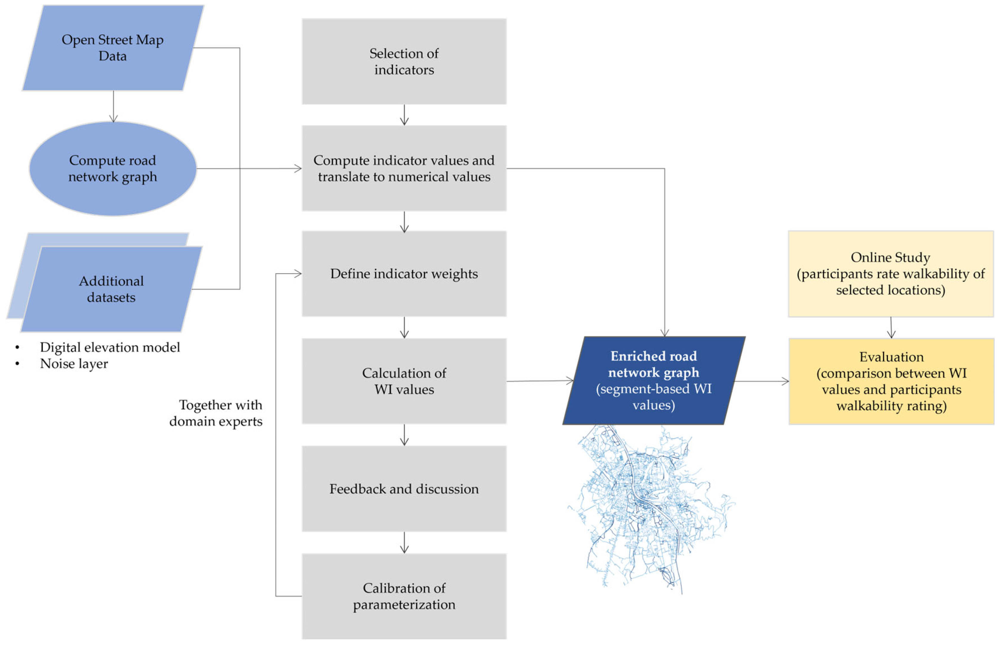
2. Materials and Methods
2.1. Walkability Assessment Model
2.1.1. Network Graph Preparation
2.1.2. Defining and Computing Indicator Values
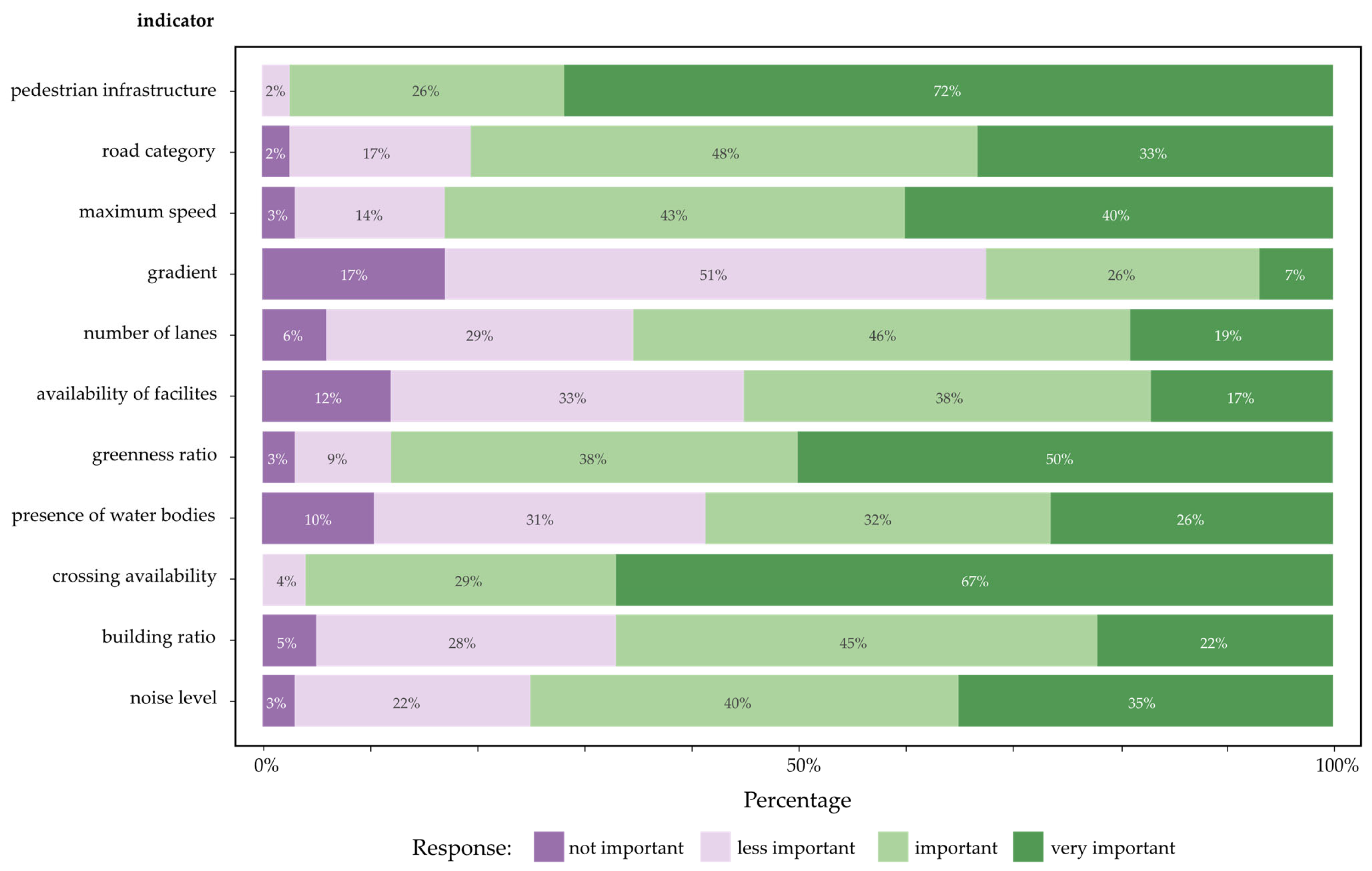
- Pedestrian infrastructure
- Road category
- Maximum speed
- Gradient
- Number of lanes
- Availability of facilities
- Greenness ratio
- Presence of water bodies
- Crossing availability
- Building ratio
- Noise level
2.1.3. Weighting of Indicators
2.1.4. Walkability Index Calculation
2.2. Evaluation
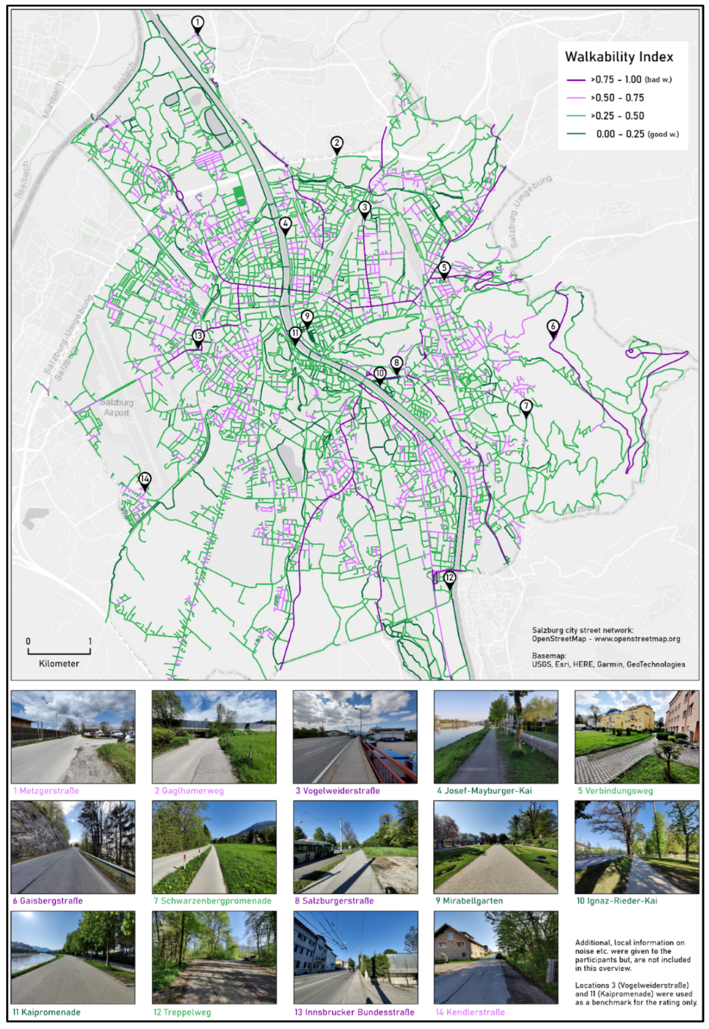
2.2.1. Data Sources and Index Calculation
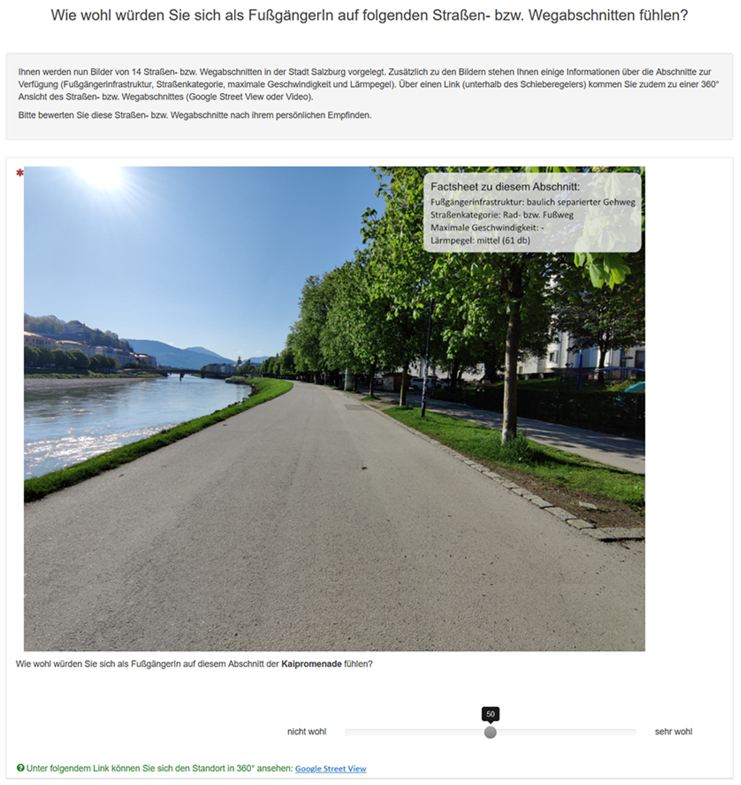
2.2.2. Online Survey
3. Results
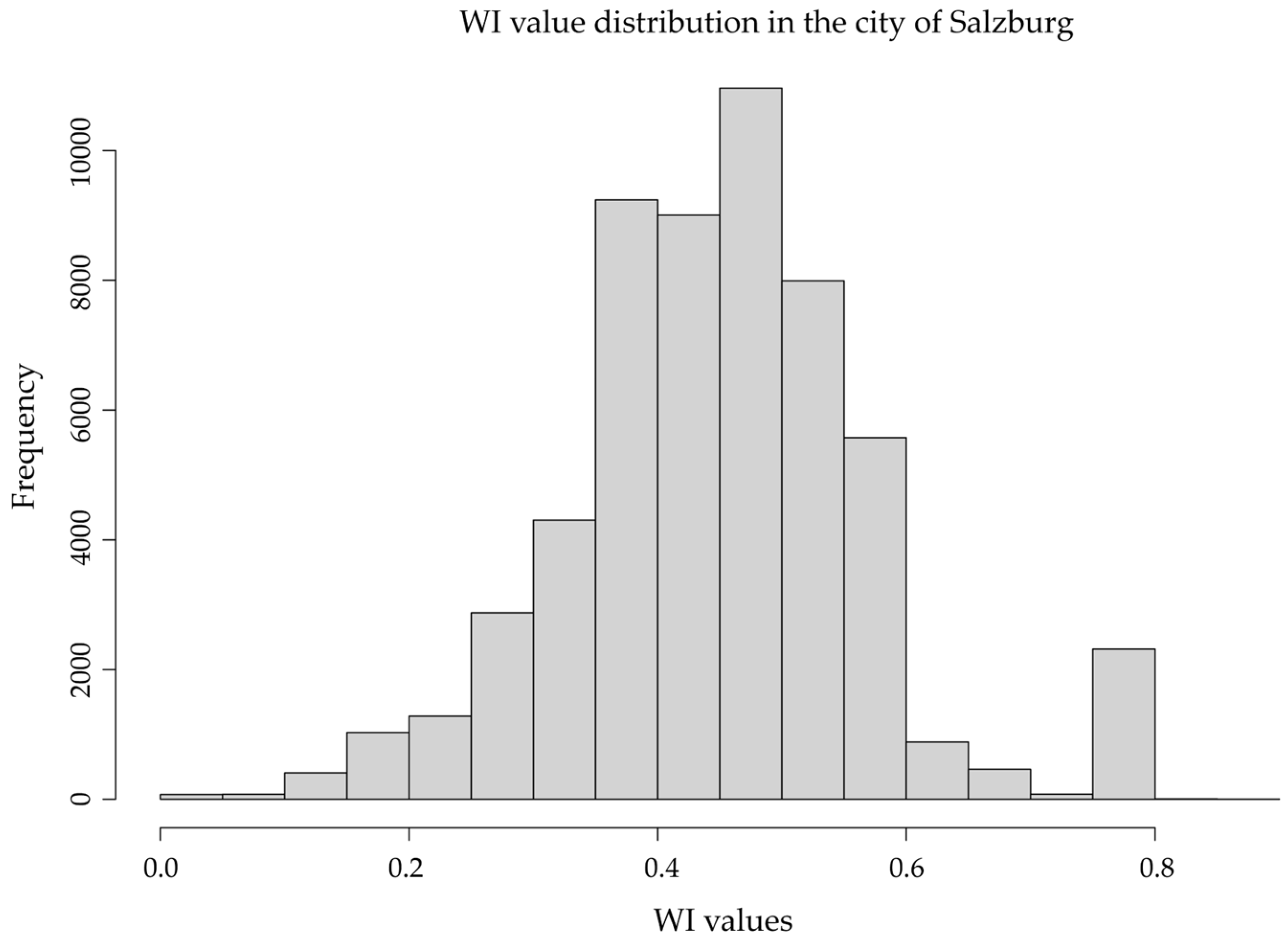
3.1. Model Results: Walkability
3.2. Online Survey Results
3.2.1. Comparison Between Participant’s Walkability Ratings and WI Value
3.2.2. Participants’ Ratings of Indicators
4. Discussion
4.1. Indicator Selection and Weighting
4.2. Model Outputs
4.2.1. Overwrite Option
4.2.2. Reflections on Data Quality
5. Conclusions
Supplementary Materials
Author Contributions
Funding
Institutional Review Board Statement
Informed Consent Statement
Data Availability Statement
Conflicts of Interest
Abbreviations
| NCD | Noncommunicable Disease |
| SDG | Sustainable Development Goals |
| WI | Walkability Index |
| GIS | Geographic Information Systems |
| OSM | OpenStreetMap |
| OGD | Open Governmental Data |
| AHP | Analytic Hierarchy Process |
References
- Kumar, P.G.; Lekhana, P.; Tejaswi, M.; Chandrakala, S. Effects of vehicular emissions on the urban environment-a state of the art. Mater. Today Proc. 2021, 45, 6314–6320. [Google Scholar] [CrossRef]
- Peyravi, B.; Peleckienė, V.; Vaičiūtė, K. Research on the impact of motorization rate and technological development on climate change in lithuania in the context of the European green deal. Sustainability 2022, 14, 11610. [Google Scholar] [CrossRef]
- World Health Organization. Global Status Report on Physical Activity 2022; World Health Organization: Geneva, Switzerland, 2022. [Google Scholar]
- Santos, A.C.; Willumsen, J.; Meheus, F.; Ilbaw, A.; Bull, F. The cost of inaction on physical inactivity to healthcare systems. Lancet Glob. Health 2023, 11, e32–e39. [Google Scholar] [CrossRef] [PubMed]
- UN General Assembly. Transforming Our World: The 2030 Agenda for Sustainable Development; United Nations: New York, NY, USA, 2015; Available online: https://sdgs.un.org/sites/default/files/publications/21252030%20Agenda%20for%20Sustainable%20Development%20web.pdf (accessed on 10 October 2024).
- Pikora, T.; Giles-Corti, B.; Bull, F.; Jamrozik, K.; Donovan, R. Developing a framework for assessment of the environmental determinants of walking and cycling. Soc. Sci. Med. 2003, 56, 1693–1703. [Google Scholar] [CrossRef] [PubMed]
- Ewing, R.; Cervero, R. Travel and the built environment: A meta-analysis. J. Am. Plan. Assoc. 2010, 76, 265–294. [Google Scholar] [CrossRef]
- Alfonzo, M.A. To walk or not to walk? The hierarchy of walking needs. Environ. Behav. 2005, 37, 808–836. [Google Scholar] [CrossRef]
- Ellis, G.; Hunter, R.; Tully, M.A.; Donnelly, M.; Kelleher, L.; Kee, F. Connectivity and physical activity: Using footpath networks to measure the walkability of built environments. Environ. Plan. B Plan. Des. 2016, 43, 130–151. [Google Scholar] [CrossRef]
- Ferrer, S.; Ruiz, T. The impact of the built environment on the decision to walk for short trips: Evidence from two Spanish cities. Transp. Policy 2018, 67, 111–120. [Google Scholar] [CrossRef]
- Kent, J.L.; Ma, L.; Mulley, C. The objective and perceived built environment: What matters for happiness? Cities Health 2017, 1, 59–71. [Google Scholar] [CrossRef]
- Pikora, T.J.; Giles-Corti, B.; Knuiman, M.W.; Bull, F.C.; Jamrozik, K.; Donovan, R.J. Neighborhood environmental factors correlated with walking near home: Using SPACES. Med. Sci. Sports Exerc. 2006, 38, 708–714. [Google Scholar] [CrossRef]
- Saelens, B.E.; Handy, S.L. Built environment correlates of walking: A review. Med. Sci. Sports Exerc. 2008, 40 (Suppl. S7), S550. [Google Scholar] [CrossRef] [PubMed]
- Saelens, B.E.; Sallis, J.F.; Frank, L.D. Environmental correlates of walking and cycling: Findings from the transportation, urban design, and planning literatures. Ann. Behav. Med. 2003, 25, 80–91. [Google Scholar] [CrossRef] [PubMed]
- Wang, H.; Yang, Y. Neighbourhood walkability: A review and bibliometric analysis. Cities 2019, 93, 43–61. [Google Scholar] [CrossRef]
- Frank, L.D.; Sallis, J.F.; Saelens, B.E.; Leary, L.; Cain, K.; Conway, T.L.; Hess, P.M. The development of a walkability index: Application to the Neighborhood Quality of Life Study. Br. J. Sports Med. 2010, 44, 924–933. [Google Scholar] [CrossRef]
- Leslie, E.; Coffee, N.; Frank, L.; Owen, N.; Bauman, A.; Hugo, G. Walkability of local communities: Using geographic information systems to objectively assess relevant environmental attributes. Health Place 2007, 13, 111–122. [Google Scholar] [CrossRef]
- Carr, L.J.; Dunsiger, S.I.; Marcus, B.H. Walk score™ as a global estimate of neighborhood walkability. Am. J. Prev. Med. 2010, 39, 460–463. [Google Scholar] [CrossRef]
- Rodrigue, L.; Daley, J.; Ravensbergen, L.; Manaugh, K.; Wasfi, R.; Butler, G.; El-Geneidy, A. Factors influencing subjective walkability. J. Transp. Land Use 2022, 15, 709–727. [Google Scholar] [CrossRef]
- Kim, S.; Park, S.; Lee, J.S. Meso-or micro-scale? Environmental factors influencing pedestrian satisfaction. Transp. Res. Part D Transp. Environ. 2014, 30, 10–20. [Google Scholar] [CrossRef]
- Steinmetz-Wood, M.; Velauthapillai, K.; O’Brien, G.; Ross, N.A. Assessing the micro-scale environment using Google Street View: The virtual systematic tool for evaluating pedestrian streetscapes (virtual-STEPS). BMC Public Health 2019, 19, 1246. [Google Scholar] [CrossRef]
- Bartzokas-Tsiompras, A.; Bakogiannis, E.; Nikitas, A. Global microscale walkability ratings and rankings: A novel composite indicator for 59 European city centres. J. Transp. Geogr. 2023, 111, 103645. [Google Scholar] [CrossRef]
- Guzman, L.A.; Arellana, J.; Castro, W.F. Desirable streets for pedestrians: Using a street-level index to assess walkability. Transp. Res. Part D Transp. Environ. 2022, 111, 103462. [Google Scholar] [CrossRef]
- Chan, E.T.; Schwanen, T.; Banister, D. Towards a multiple-scenario approach for walkability assessment: An empirical application in Shenzhen, China. Sustain. Cities Soc. 2021, 71, 102949. [Google Scholar] [CrossRef]
- Rahman, A. A GIS-based, microscale walkability assessment integrating the local topography. J. Transp. Geogr. 2022, 103, 103405. [Google Scholar] [CrossRef]
- Carmona, M. Place value: Place quality and its impact on health, social, economic and environmental outcomes. J. Urban Des. 2019, 24, 1–48. [Google Scholar] [CrossRef]
- Stigsdotter, U.K.; Ekholm, O.; Schipperijn, J.; Toftager, M.; Kamper-Jørgensen, F.; Randrup, T.B. Health promoting outdoor environments-Associations between green space, and health, health-related quality of life and stress based on a Danish national representative survey. Scand. J. Public Health 2010, 38, 411–417. [Google Scholar] [CrossRef]
- D’Orso, G.; Migliore, M. A GIS-based method for evaluating the walkability of a pedestrian environment and prioritised investments. J. Transp. Geogr. 2020, 82, 102555. [Google Scholar] [CrossRef]
- Koo, B.W.; Guhathakurta, S.; Botchwey, N. Development and validation of automated microscale walkability audit method. Health Place 2022, 73, 102733. [Google Scholar] [CrossRef]
- Ye, Y.; Jia, C.; Winter, S. Measuring Perceived Walkability at the City Scale Using Open Data. Land 2024, 13, 261. [Google Scholar] [CrossRef]
- Huang, X.; Zeng, L.; Liang, H.; Li, D.; Yang, X.; Zhang, B. Comprehensive walkability assessment of urban pedestrian environments using big data and deep learning techniques. Sci. Rep. 2024, 14, 26993. [Google Scholar] [CrossRef]
- Wang, M.; Haworth, J.; Chen, H.; Liu, Y.; Shi, Z. Investigating the potential of crowdsourced street-level imagery in understanding the spatiotemporal dynamics of cities: A case study of walkability in Inner London. Cities 2024, 153, 105243. [Google Scholar] [CrossRef]
- Loidl, M.; Zagel, B. Assessing bicycle safety in multiple networks with different data models. GI_Forum 2014, 2, 144–154. [Google Scholar] [CrossRef]
- Werner, C.; Van der Meer, L.; Kaziyeva, D.; Stutz, P.; Wendel, R.; Loidl, M. Bikeability of road segments: A open, adjustable and extendible model. J. Cycl. Micromobility Res. 2024, 2, 100040. [Google Scholar] [CrossRef]
- Werner, C.; Wendel, R.; Kaziyeva, D.; Stutz, P.; van der Meer, L.; Effertz, L.; Zagel, B.; Loidl, M. NetAScore: An open and extendible software for segment-scale bikeability and walkability. Environ. Plan. B Urban Anal. City Sci. 2024, 52, 265–274. [Google Scholar] [CrossRef]
- Appolloni, L.; Corazza, M.V.; D’Alessandro, D. The pleasure of walking: An innovative methodology to assess appropriate walkable performance in urban areas to support transport planning. Sustainability 2019, 11, 3467. [Google Scholar] [CrossRef]
- Dumbaugh, E.; Gattis, J.L. Safe streets, livable streets. J. Am. Plan. Assoc. 2005, 71, 283–300. [Google Scholar] [CrossRef]
- Fonseca, F.; Ribeiro, P.J.G.; Conticelli, E.; Jabbari, M.; Papageorgiou, G.; Tondelli, S.; Ramos, R.A.R. Built environment attributes and their influence on walkability. Int. J. Sustain. Transp. 2022, 16, 660–679. [Google Scholar] [CrossRef]
- Gascon, M.; Zijlema, W.; Vert, C.; White, M.P.; Nieuwenhuijsen, M.J. Outdoor blue spaces, human health and well-being: A systematic review of quantitative studies. Int. J. Hygen Environ. Health 2017, 220, 1207–1221. [Google Scholar] [CrossRef]
- Landis, B.W.; Vattikuti, V.R.; Ottenberg, R.M.; McLeod, D.S.; Guttenplan, M. Modeling the roadside walking environment: Pedestrian level of service. Transp. Res. Rec. 2001, 1773, 82–88. [Google Scholar] [CrossRef]
- Singh, R. Factors affecting walkability of neighborhoods. Procedia-Soc. Behav. Sci. 2016, 216, 643–654. [Google Scholar] [CrossRef]
- Sisiopiku, V.P.; Akin, D. Pedestrian behaviors at and perceptions towards various pedestrian facilities: An examination based on observation and survey data. Transp. Res. Part F Traffic Psychol. Behav. 2003, 6, 249–274. [Google Scholar] [CrossRef]
- Yoon, S.; Moon, Y.; Jeong, J.; Park, C.R.; Kang, W. A Network-Based Approach for Reducing Pedestrian Exposure to PM2. 5 Induced by Road Traffic in Seoul. Land 2021, 10, 1045. [Google Scholar] [CrossRef]
- Stadt Salzburg. Grundlagenbericht zum Neuen Räumlichen Entwicklungskonzept der Stadt Salzburg; Stadt Salzburg, MA 5/03—Amt für Stadtplanung und Verkehr: Salzburg, Austria, 2021; Available online: https://www.stadt-salzburg.at/rek-grundlagenbericht (accessed on 10 October 2024).
- Planet OSM. Available online: https://planet.osm.org (accessed on 31 March 2019).
- Land Kärnten. Digitales Geländemodell (DGM) Österreich. Available online: https://www.data.gv.at/katalog/en/dataset/land-ktn_digitales-gelandemodell-dgm-osterreich (accessed on 31 March 2019).
- Bundesministerium für Klimaschutz, Umwelt, Energie, Mobilität, Innovation & Technologie. Lärmzonen Umgebungslärmkartierung 2017—Strasse Österreich. Available online: https://geometadatensuche.inspire.gv.at/metadatensuche/srv/api/records/125ec87c-7120-48a7-bd2c-2718cbf878c6 (accessed on 30 June 2018).
- Pakkar, M.S. A hierarchical aggregation approach for indicators based on data envelopment analysis and analytic hierarchy process. Systems 2016, 4, 6. [Google Scholar] [CrossRef]
- Saisana, M.; Saltelli, A.; Tarantola, S. Uncertainty and sensitivity analysis techniques as tools for the quality assessment of composite indicators. J. R. Stat. Soc. Ser. A Stat. Soc. 2005, 168, 307–323. [Google Scholar] [CrossRef]
- Kaziyeva, D.; Stutz, P.; Wallentin, G.; Loidl, M. Large-scale agent-based simulation model of pedestrian traffic flows. Comput. Environ. Urban Syst. 2023, 105, 102021. [Google Scholar] [CrossRef]
- Zacharopoulou, D.; Skopeliti, A.; Nakos, B. Assessment and visualization of OSM consistency for European cities. ISPRS Int. J. Geo-Inf. 2021, 10, 361. [Google Scholar] [CrossRef]
- Loidl, M.; Butzhammer, A.; Castellazzi, B.; Prinz, T.; Zagel, B. Considering Spatial Factors in Promoting Active, Healthy Commuting. GI_Forum 2018, 6, 162–176. [Google Scholar] [CrossRef]

| Indicator and Short Description | Main Aspect of Walkability | Default Indicator Weight | Indicator Value with Default Numerical Mapping |
|---|---|---|---|
| Pedestrian infrastructure (availability and type of pedestrian infrastructure) | safety | 0.4 | No infrastructure: 1 |
| Sidewalk: 0.5 | |||
| Stairs: 0.3 | |||
| Pedestrians separated but mixed with cyclists: 0.15 | |||
| Pedestrian street: 0 | |||
| Pedestrians separated: 0 | |||
| Road category (proxy for traffic volume and potentially the share of heavy goods vehicles) | safety | 0.3 | Primary: 1 |
| Secondary: 0.8 | |||
| Residential: 0.2 | |||
| Service: 0.15 | |||
| Calmed: 0.1 | |||
| Path: 0 | |||
| No motorised traffic: 0 | |||
| Maximum speed (km/h) (speed limit of motorised traffic) | safety | 0.3 | ≥100: 1 |
| ≥80: 0.8 | |||
| ≥70: 0.7 | |||
| ≥60: 0.6 | |||
| ≥50: 0.4 | |||
| ≥40: 0.15 | |||
| ≥30: 0.1 | |||
| <30: 0 | |||
| Gradient (steepness of the road or path: physical effort needed) | comfort | 0.3 | ≥12 %: 0.75 |
| <12%: 0.5 | |||
| <6%: 0.3 | |||
| <3%, >−3%: 0 | |||
| >−6 %: 0.3 | |||
| >−12 %: 0.5 | |||
| ≤−12 %: 0.75 | |||
| Number of lanes (proxy for traffic volume) | safety | 0.1 | >4: 1 |
| 4: 0.9 | |||
| 3: 0.8 | |||
| 2: 0.5 | |||
| 0–1: 0 | |||
| Availability of facilities (points of interest in proximity) | functionality | 0.3 | No: 1 |
| Yes: 0 | |||
| Greenness ratio (greenness of surrounding) | aesthetics | 0.3 | ≥75%: 0 |
| ≥50%: 0.1 | |||
| ≥5: 0.2 | |||
| >0: 0.3 | |||
| 0: 1 | |||
| Presence of water bodies (proximity to water bodies) | aesthetics | 0.4 | No: 1 |
| Yes: 0 | |||
| Building ratio (density of built environment) | comfort | 0.1 | ≥80%: 1 |
| ≥60%: 0.8 | |||
| ≥40%: 0.6 | |||
| ≥20%: 0.4 | |||
| >0%: 0.2 | |||
| 0%: 0 | |||
| Crossing availability | safety | 0.2 | No, and road category is primary or secondary: 1 |
| No, and road category is residential: 0.5 | |||
| Yes, and road category is smaller than residential: 0 | |||
| Noise level (db) (ambient noise level) | comfort | 0.3 | ≥70: 1 |
| ≥55: 0.4 | |||
| ≥10: 0.2 | |||
| ≥0: 0 | |||
| ∑3 |
| Category | Subcategory | Count (%) |
|---|---|---|
| Gender | male | 224 (33.9%) |
| female | 431 (65.5%) | |
| diverse | 5 (0.8%) | |
| Age (in years) | <20 | 11 (1.7%) |
| 20–34 | 357 (57.1%) | |
| 35–49 | 137 (20.8%) | |
| 50–65 | 113 (17.1%) | |
| >65 | 42 (6.4%) | |
| Familiarity with the city of Salzburg | very familiar | 355 (53.8%) |
| familiar | 187 (28.3%) | |
| somewhat familiar | 77 (11.7%) | |
| not familiar | 36 (5.5%) | |
| not familiar at all | 5 (0.8%) |
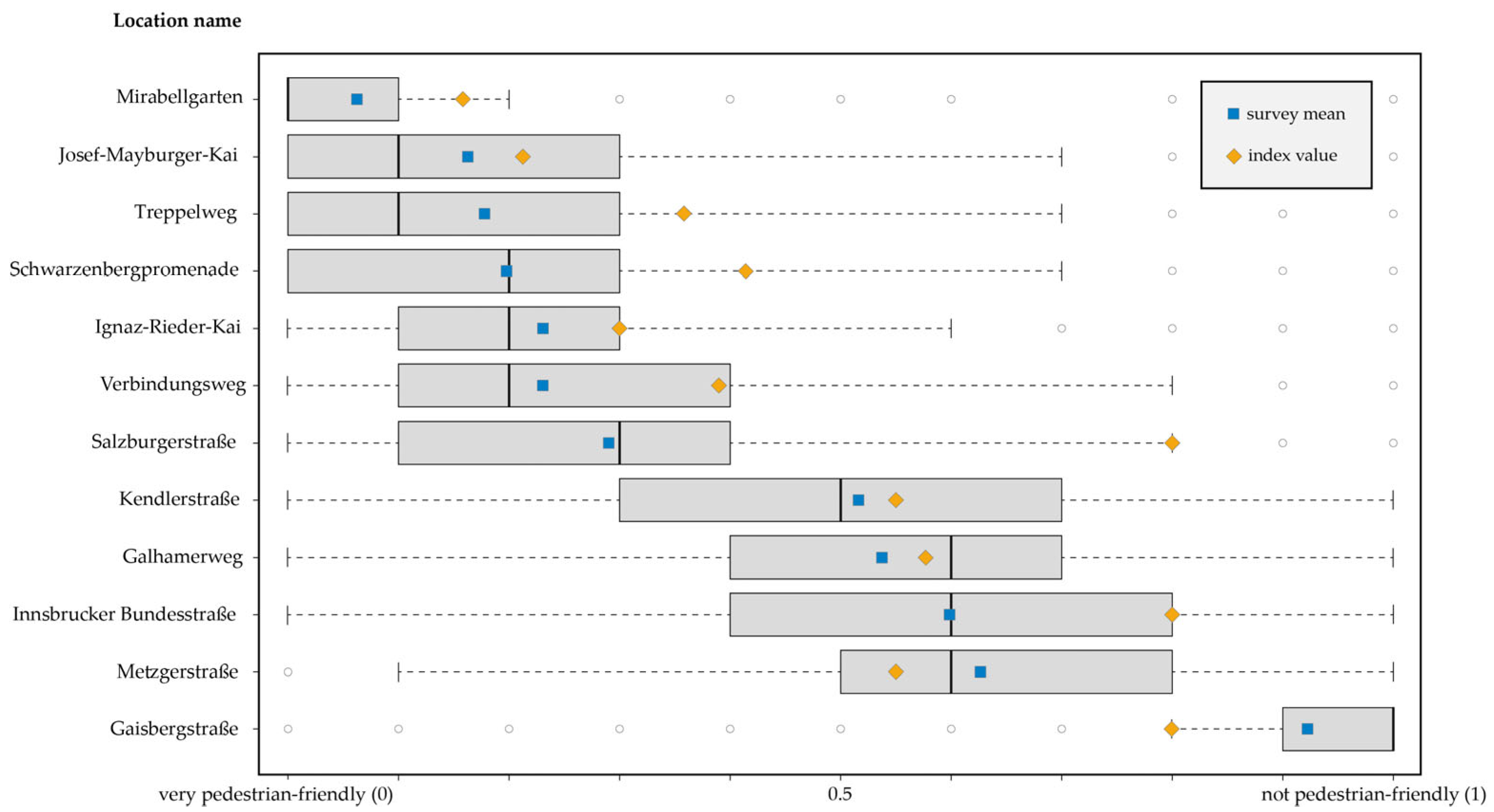
| WI Value Category | Location Name | OSM ID | WI Value | Participants’ Ratings (Mean) (n = 660) | Participants’ Ratings (Standard Deviation) |
|---|---|---|---|---|---|
| 0.0–0.25 | Mirabellgarten | 54833010 | 0.159 | 0.06 | 0.13 |
| Ignaz-Rieder-Kai | 37890723 | 0.191 | 0.23 | 0.21 | |
| Josef-Mayburger-Kai | 106620210 | 0.216 | 0.16 | 0.18 | |
| 0.25–0.5 | Verbindungsweg | 390117044 | 0.379 | 0.23 | 0.21 |
| Schwarzenbergpromenade | 33038192 | 0.417 | 0.20 | 0.19 | |
| Treppelweg | 138326112 | 0.362 | 0.18 | 0.20 | |
| 0.5–0.75 | Metzgerstraße | 67997439 | 0.552 | 0.63 | 0.20 |
| Galhamerweg | 43366570 | 0.572 | 0.6 | 0.23 | |
| Kendlerstraße | 30510578 | 0.545 | 0.52 | 0.24 | |
| 0.75–1 | Gaisbergstraße | 195910772 | 0.8 | 0.92 | 0.15 |
| Salzburgerstraße | 156209933 | 0.8 | 0.29 | 0.19 | |
| Innsbrucker Bundesstraße | 314952977 | 0.8 | 0.54 | 0.23 |
| Statistics | (n = 12) |
|---|---|
| Spearman’s rank correlation coefficient | 0.8234 * |
| p-value | 0.002 * |
| Mean absolute deviation (MAD) | 0.149 * |
Disclaimer/Publisher’s Note: The statements, opinions and data contained in all publications are solely those of the individual author(s) and contributor(s) and not of MDPI and/or the editor(s). MDPI and/or the editor(s) disclaim responsibility for any injury to people or property resulting from any ideas, methods, instructions or products referred to in the content. |
© 2025 by the authors. Licensee MDPI, Basel, Switzerland. This article is an open access article distributed under the terms and conditions of the Creative Commons Attribution (CC BY) license (https://creativecommons.org/licenses/by/4.0/).
Share and Cite
Stutz, P.; Kaziyeva, D.; Traun, C.; Werner, C.; Loidl, M. Walkability at Street Level: An Indicator-Based Assessment Model. Sustainability 2025, 17, 3634. https://doi.org/10.3390/su17083634
Stutz P, Kaziyeva D, Traun C, Werner C, Loidl M. Walkability at Street Level: An Indicator-Based Assessment Model. Sustainability. 2025; 17(8):3634. https://doi.org/10.3390/su17083634
Chicago/Turabian StyleStutz, Petra, Dana Kaziyeva, Christoph Traun, Christian Werner, and Martin Loidl. 2025. "Walkability at Street Level: An Indicator-Based Assessment Model" Sustainability 17, no. 8: 3634. https://doi.org/10.3390/su17083634
APA StyleStutz, P., Kaziyeva, D., Traun, C., Werner, C., & Loidl, M. (2025). Walkability at Street Level: An Indicator-Based Assessment Model. Sustainability, 17(8), 3634. https://doi.org/10.3390/su17083634