Article

Response of the Evolution of Basin Hydrometeorological Drought to ENSO: A Case Study of the Jiaojiang River Basin in Southeast China

by
He Qiu
1,2,3,
Hao Chen
1,2,3,4,*,
Yijing Chen
1,2,3,
Chuyu Xu
1,2,3,
Yuxue Guo
5,
Saihua Huang
1,2,3,
Hui Nie
1,2,3 and
Huawei Xie
1,2,3
1
School of Hydraulic Engineering, Zhejiang University of Water Resources and Electric Power, Hangzhou 310018, China
2
International Science and Technology Cooperation Base for Utilization and Sustainable Development of Water Resources, Zhejiang University of Water Resources and Electric Power, Hangzhou 310018, China
3
Estuarine and Coastal Disaster Prevention and Mitigation and Ecological Governance Institute, Zhejiang University of Water Resources and Electric Power, Hangzhou 310018, China
4
Nanxun Innovation Institute, Zhejiang University of Water Resources and Electric Power, Hangzhou 310018, China
5
Institute of Hydrology and Water Resources, College of Civil Engineering and Architecture, Zhejiang University, Hangzhou 310058, China
*
Author to whom correspondence should be addressed.
Sustainability 2025, 17(6), 2616; https://doi.org/10.3390/su17062616
Submission received: 14 February 2025 / Revised: 11 March 2025 / Accepted: 13 March 2025 / Published: 16 March 2025

Abstract

:
Drought is one of the most widespread natural disasters globally, and its spatiotemporal distribution is profoundly influenced by the El Niño-Southern Oscillation (ENSO). As a typical humid coastal basin, the Jiaojiang River Basin in southeastern China frequently experiences hydrological extremes such as dry spells during flood seasons. This study focuses on the Jiaojiang River Basin, aiming to investigate the response mechanisms of drought evolution to ENSO in coastal regions. This study employs 10-day scale data from 1991 to 2020 to investigate the drought mechanisms driven by ENSO through a comprehensive framework that combines standardized indices with climate–drought correlation analysis. The results indicate that the Comprehensive Drought Index (CDI), integrating the advantages of the Standardized Precipitation Index (SPI) and Standardized Runoff Index (SRI), effectively reflects the basin’s combined meteorological and hydrological wet-dry characteristics. A strong response relationship exists between drought indices in the Jiaojiang River Basin and ENSO events. Drought characteristics in the basin vary significantly during different ENSO phases. The findings can provide theoretical support for the construction of resilient regional water resource systems, and the research framework holds reference value for sustainable development practices in similar coastal regions globally.

1. Introduction

Drought, characterized by its slow onset, cumulative effects, and extensive spatial coverage, is one of the most widespread and devastating natural disasters globally [1]. Although findings from various global studies are not always entirely consistent, in most regions, there is a significant increasing trend in the frequency and intensity of extreme hydro-meteorological events [2]. Existing studies have indicated that sea surface temperature and ocean-induced circulation anomalies are critical factors contributing to drought events [3,4,5,6]. Oceanic environmental conditions, particularly sea surface temperatures in the Pacific, Atlantic, and Indian Oceans, significantly influence global precipitation distribution. The El Niño-Southern Oscillation (ENSO), as the most prominent interannual oscillation signal in the climate system, alters global heat and moisture transport patterns through air–sea interactions, profoundly impacting the spatiotemporal distribution of regional droughts [7,8].
The occurrence patterns of ENSO and its influence on global climate have long been a focal point in the scientific community. The United Nations report “The Global Threat of Drylands” highlights that ENSO alternations modulate the balance between precipitation and evapotranspiration, leading to significant differentiation between coastal and inland drought types [9,10]. Coastal droughts are often directly associated with thermal anomalies in adjacent marine areas. Zhu et al. [11] found that ENSO events exacerbate seasonal instability in river flows, intensifying water resource allocation pressures, particularly in the circum-Pacific region, where rapid transitions between drought and flood have become the norm.
Coastal regions, as the frontier of land–sea interactions, experience drought evolution influenced not only by terrestrial climatic processes but also by marine thermal conditions, ocean current variations, and atmospheric teleconnection patterns [12]. Research has shown that coastal drought events are often accompanied by marine heatwaves or sea surface temperature anomalies driven by ENSO. Furthermore, against the backdrop of global dryland expansion, 40.6% of terrestrial areas have exhibited aridification trends, with coastal regions, due to their dense populations and economic activity, experiencing more pronounced impacts on socio-economic and ecological systems [13,14,15]. Therefore, deciphering the response mechanisms of coastal droughts to ENSO provides a critical window into understanding land-sea atmosphere coupling processes and offers scientific support for regional water resource management and early disaster warning [16]. However, existing research primarily focuses on large-scale or continental scales, lacking systematic analysis of drought evolution characteristics in small- and medium-sized coastal basins and their dynamic links with ENSO. This knowledge gap severely constrains the formulation of sustainable development strategies at the local level.
Drought and wetness, as binary attributes of hydrometeorological events, require precise quantitative indicator systems for monitoring and assessment [17,18]. Traditional univariate drought indices, such as the Standardized Precipitation Index (SPI), Standardized Runoff Index (SRI), Standardized Precipitation Evapotranspiration Index (SPEI), and Palmer Drought Severity Index (PDSI), are insufficient to comprehensively characterize the complex impacts of drought and wetness on regional socio-economic development [19,20,21,22,23]. Therefore, this study constructs a Comprehensive Drought Index (CDI) based on the Copula function, which can simultaneously represent a basin’s joint meteorological and hydrological wet-dry characteristics. CDI exhibits accuracy, comprehensiveness, sensitivity, and stability advantages in reflecting the intensity of wet and dry events [24,25].
The evolution of drought events exhibits significant nonlinearity and abruptness, with complex and rapid changes occurring over short periods [26,27,28]. Due to their large periods, traditional monthly or even annual-scale data face severe limitations in capturing the rapid response processes of drought events, making it difficult to comprehensively and meticulously reflect the dynamic evolution of droughts or precisely depict their characteristics at different stages. Therefore, this study innovatively employs 10-day scale data to finely delineate drought dynamics and accurately match ENSO fluctuations, enabling more detailed correlation analysis, trend analysis, and more precise quantification of the relationship between drought evolution and ENSO in coastal regions. The research findings can directly contribute to the specific requirements of enhancing resilience to disasters outlined in the Sustainable Development Goals.
Therefore, this study focuses on the Jiaojiang River Basin, a typical coastal basin in southeastern China, with the following objectives: (1) to calculate meteorological and hydrological data based on the 10-day scale and analyze the wet-dry trends in the Jiaojiang River Basin; (2) to summarize the wet-dry evolution patterns in coastal regions and analyze the driving effects of ENSO on these patterns; and (3) to elucidate the modulation mechanisms of different ENSO phases (El Niño/La Niña) on the intensity and duration of droughts in the Jiaojiang River Basin. Through this research, we aim to fill the knowledge gap regarding the response mechanisms of droughts to ENSO in small and medium-sized coastal basins and provide scientific references for disaster prevention and mitigation strategies in vulnerable coastal regions under global climate change. The analytical framework of “ocean-driven, watershed-responsive” proposed in this study will provide a scientific reference for achieving sustainable development in vulnerable coastal areas under global climate change.

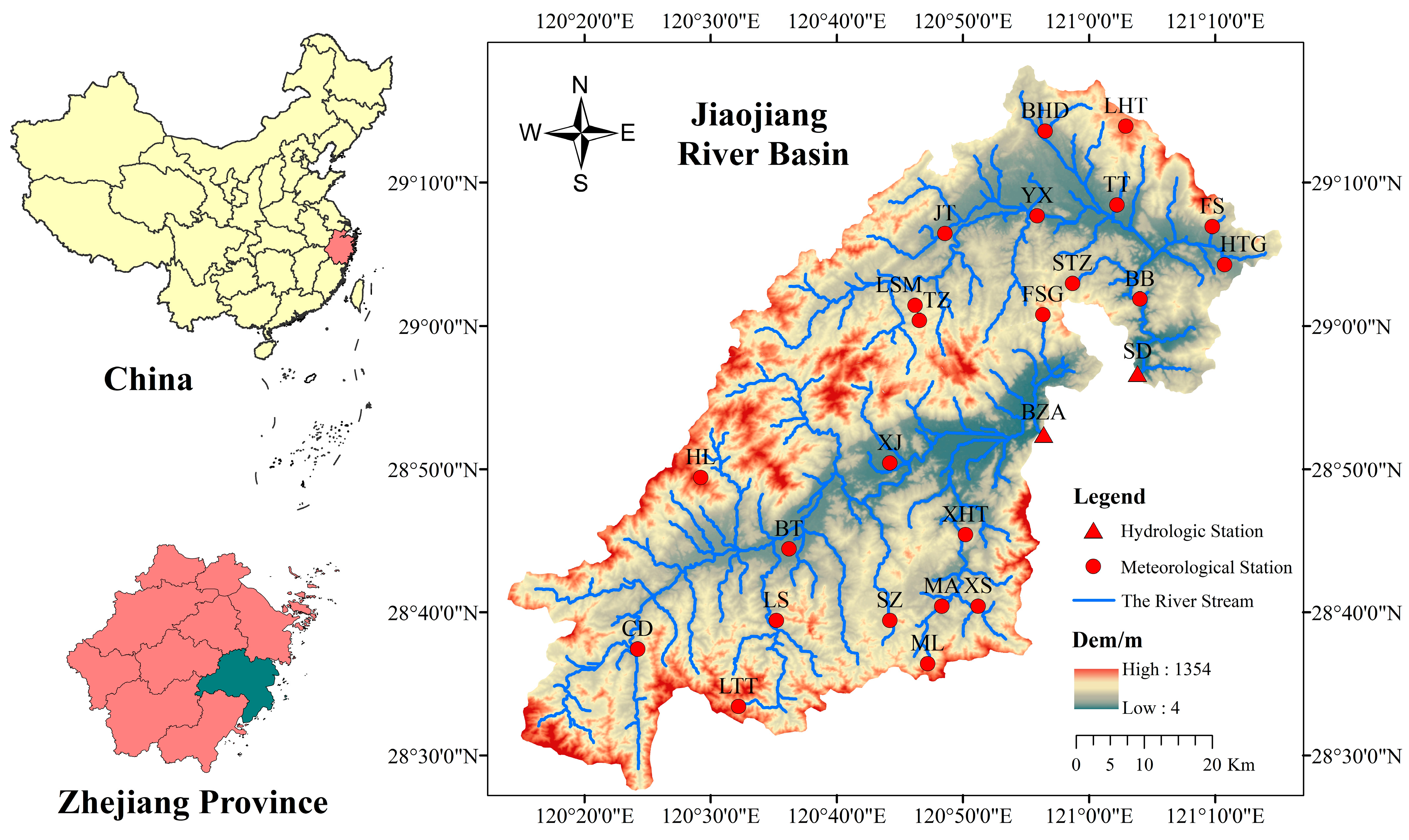
2. Study Area and Data
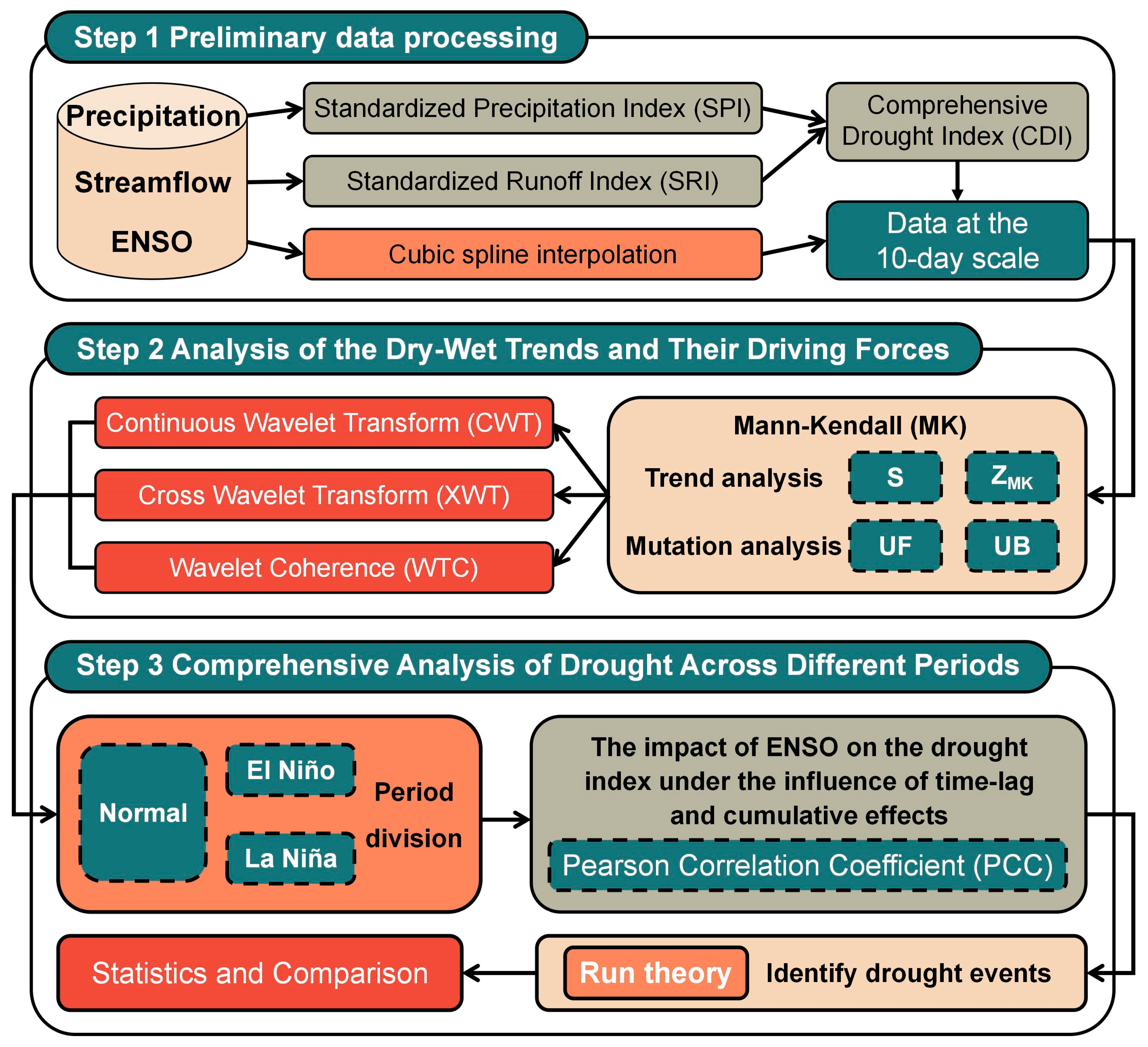
The Jiaojiang River Basin is located in the central coastal area of Zhejiang Province in southeastern China and is one of the eight major river basins in Zhejiang Province. It spans from 120°17′6″ to 121°41′00″ east longitude and 28°32′2″ to 29°20′29″ north latitude, with a basin area of 6603 km2 [29]. The Jiaojiang River Basin lies within the subtropical monsoon climate zone, with an average annual precipitation of 1500–2000 mm, but the distribution within the year is highly uneven [30]. Influenced by the advance and retreat of the Western Pacific Subtropical High modulated by ENSO, the basin frequently experiences abrupt transitions between drought and flood. The terrain slopes from west to east, with mountain ranges in the northwest and a mosaic of coastal plains and low hills. The basin features a complex topography of mountains, plains, and estuaries, with a dense network of rivers. Its hydrological processes are susceptible to atmospheric circulation anomalies, making it an ideal case for studying the response of drought evolution to ENSO in coastal regions.
The specific hydrological stations and their distribution within the basin are shown in Figure 1. In this study, we rigorously selected and utilized daily runoff data from all the aforementioned hydrological stations, as well as daily precipitation data from corresponding meteorological stations. The data cover a comprehensive 30-year period from 1991 to 2020, ensuring the completeness and continuity of the dataset. The situation of each station is shown in Table 1.
The ENSO data used in this study were obtained from the official website of the National Oceanic and Atmospheric Administration (NOAA) (https://psl.noaa.gov/enso/dashboard.html (accessed on 10 January 2025)). Monthly-scale data were interpolated into 10-day scale data using cubic spline interpolation. According to statistics, 9 El Niño events and 8 La Niña events occurred during the 30 years from 1991 to 2020 (Table 2).

3. Methodology

This study focuses on the “response of drought evolution to ENSO in coastal regions”. It is structured into three core steps (Figure 2): Stage 1: Precipitation, runoff, and ENSO data were collected, and the 10-day scale Standardized Precipitation Index (SPI), Standardized Runoff Index (SRI), and Comprehensive Drought Index (CDI) were calculated. ENSO data were interpolated into 10-day scale data using cubic spline interpolation. Stage 2: The Mann–Kendall (MK) method was employed for trend analysis and abrupt change detection. Continuous Wavelet Transform (CWT), Cross-Wavelet Transform (XWT), and Wavelet Coherence (WTC) were further applied to analyze the relationship between drought indices and ENSO. Stage 3: The data were divided into periods, and the Pearson Correlation Coefficient (PCC) was used to quantitatively analyze the time lag and cumulative effects of drought indices on ENSO. Run theory was applied to identify drought events, and differences across different periods were compared.

3.1. Drought Index

3.1.1. Standardized Precipitation Index (SPI) and Standardized Runoff Index (SRI)

The Standardized Precipitation Index (SPI) objectively describes the probability of precipitation over multiple time scales by calculating the cumulative probability of rainfall within a given period, reflecting the influence of precipitation on drought conditions. SPI effectively captures drought conditions based on the magnitude of precipitation, is straightforward to calculate, and requires only precipitation data as input. Additionally, this drought index demonstrates robust computational stability across different regions and periods [31,32,33].
The Gamma distribution function is employed to describe the variation in precipitation, followed by normalization to derive the SPI. Assuming the precipitation over a specific time scale is denoted as x , the probability density function of the Gamma distribution is expressed as follows:
g x = 1 β α Γ α x α 1 e x β   x > 0
where x represents precipitation, mm; α and β are the shape parameter and scale parameter, respectively, which can be obtained using the maximum likelihood estimation method; Γ α is the Gamma function.
The cumulative probability for a given time scale can be calculated as follows:
G x = 0 x g x d x = 1 β α Γ α 0 x x α 1 e β d x
The cumulative probability H x can be transformed into the standard normal distribution function using the following equation to calculate the SPI value:
S P I = t c 0 + c 1 t + c 2 t 2 1 + d 1 t + d 2 t 2 + d 3 t 3 , t = l n 1 H x 2 , 0 < H x 0.5 t c 0 + c 1 t + c 2 t 2 1 + d 1 t + d 2 t 2 + d 3 t 3 , t = l n 1 1 H x 2 , 0.5 < H x 1
where t is a parameter; H x is cumulative probability. c 0 = 2.515517 ; c 1 = 0.802853 ; c 2 = 0.010328 ; d 1 = 1.432788 ; d 2 = 0.189269 ; d 3 = 0.001308 .
This study constructed Thiessen polygons for the two sub-basins, utilized weighted precipitation data from meteorological stations to represent the precipitation data at hydrological stations, and subsequently calculated the SPI for BZA and SD. Shukla and Wood proposed the Standardized Runoff Index (SRI) in 2008, drawing on the concept of the SPI. The calculation method for SRI is similar to that of SPI.

3.1.2. Comprehensive Drought Index (CDI)

Based on the Frank Copula function, a Composite Drought Index (CDI) is constructed by combining SPI (meteorological factor) and SRI (hydrological factor). The CDI can simultaneously reflect meteorological and hydrological wetness and dryness conditions [34,35]. The Copula function simplifies the problem by transforming marginal variables into uniformly distributed variables, obviating the need to consider many different marginal distributions, and then defining the dependence as a joint distribution on the uniform distributions. The Frank Copula function is defined as follows: Let H be an n-dimensional distribution function with marginal distributions denoted by F 1 , F 2 , …, F n , then there exists an n-dimensional Copula function C such that for any x R n :
H x 1 , x 2 , , x n = C F 1 x 1 , F 2 x 2 , , F n x n
The specific steps for developing a bivariate joint distribution using the Frank Copula function include: (1) determining the marginal distributions of each variable; (2) estimating the parameters of the Copula function; (3) selecting the appropriate Copula function based on evaluation metrics to establish the joint distribution; and (4) conducting corresponding statistical analyses based on the observed distribution.
Following the classification method of SPI, all three drought indices use −0.5 as the threshold to categorize drought into the following types (Table 3):

3.2. Cubic Spline Interpolation

Cubic spline interpolation is a numerical method that constructs a smooth interpolating curve using piecewise cubic polynomials. Its core principle lies in transforming the global smoothness problem into a locally constrained recursive solution, ensuring that the interpolating function is twice continuously differentiable while maintaining excellent numerical stability. It can be described as follows:
Given a sequence of nodes a = x 0 < x 1 < < x n = b and their corresponding function values y 0 < y 1 < < y n , a piecewise cubic polynomial function is built as:
x = S 0 x , x x 0 , x 1 S 1 x , x x 1 , x 2 S n 1 x , x x n 1 , x n
where the cubic polynomial on each subinterval is:
S i x = a i + b i x x i + c i x x i 2 + d i x x i 3   i = 0,1 , , n 1

3.3. Trend and Mutation Test

3.3.1. Mann–Kendall (MK) Trend Test

The Mann–Kendall (MK) trend test is a non-parametric statistical method primarily used to detect trend changes in time series data, particularly monotonic trends (upward or downward). This method does not rely on the specific distribution form of the data and is not sensitive to outliers, making it suitable for various types of time series data. It is widely applied in the hydrometeorological field [36,37,38].
Arrange the drought indices in chronological order and denote them as X = x 1 , x 2 , , x n . Define the difference function f x i x j   n i > j > 1 as follows:
f x i x j = 1 ,     x i x j < 0     0 ,       x i x j = 0     1 ,       x i x j > 0
Calculate the variance value S , which is the number of positive differences minus the number of negative differences. The formula for this calculation is:
S = j = 1 n 1 i = j + 1 n f x i x j
When S > 0 , the later observations exhibit an increasing trend compared to the previous observations; when S < 0 , the later observations exhibit a decreasing trend compared to the previous observations.
Z M K = S 1 V a r S , S > 0             0           , S = 0 S + 1 V a r S , S < 0
where V a r S represents the average of S , V a r S = 1 18 n n 1 2 n + 5 .
When Z M K > 0 , the time series data exhibit an upward trend. When Z M K < 0 , the time series data exhibit a downward trend. When Z M K > 1.96 , there is a significant trend. When Z M K 1.96 , the trend is not significant.

3.3.2. Mann–Kendall (MK) Mutation Test

The Mann–Kendall (MK) mutation test is used to detect abrupt change points in time series data, that is, whether the statistical properties of the data undergo significant changes at a certain point in time. This method is recommended and widely adopted by the World Meteorological Organization [39].
Arrange the drought indices in chronological order and denote them as X = x 1 , x 2 , , x n . Count the number of instances where each subsequent value in the dataset is more significant than all preceding values and denote this count as the sequence P k .
a i j = 1 ,   x i > x j 0 ,   x i x j   1 j i
S k = i = 1 k P k = i = 1 k j = i i = 2 a i j
Calculate the variance E S k and the mean V a r S k of S k , as follows:
E S k = k k + 1 4
V a r S k = k k 1 2 k + 5 72
The statistic U F k is given by:
U F k = S k E S k V a r S k   k > 1 , k = 1 , U F k = 0
U F k follows a standard normal distribution. When U F k > 0 , it indicates that the data sequence exhibits an upward trend. When U F k < 0 , it indicates a downward trend. When U F k > U F k , it indicates that the trend in the data sequence is significant; otherwise, the trend is not significant.
Repeating the above calculation process, the results are reversed in order, and their negative values are taken. The final sequence obtained is the U B k statistic sequence. The U F k statistic, U B k statistic, and the straight lines representing the critical values U 0.05 are analyzed on the same graph. If the U F k and U B k curves intersect between the two positive and negative critical lines, and the x-coordinate of the intersection point indicates the time of the abrupt change.

3.4. Wavelet Analysis

Wavelet analysis can effectively process time series data and analyze the trends, periodic patterns, and interrelationships of drought indices and ENSO events.

3.4.1. Continuous Wavelet Transform (CWT)

The continuous wavelet transform (CWT) is a method for simultaneously localizing a signal’s analysis in both time and frequency domains. It obtains wavelet coefficients of the signal at different scales and positions by convolving the signal with a set of wavelet basis functions, thereby revealing the time-frequency characteristics of the signal [40].
For a continuous-time signal x t , its continuous wavelet transform is defined as:
W x a , b = + x t 1 a ψ * t b a d t
where W x a , b represents the wavelet coefficient, which denotes the result of the wavelet transform of signal x t at scale a and position b ; a is the scale parameter, controlling the dilation of the wavelet; b is the translation parameter, controlling the shift of the wavelet; ψ t is the mother wavelet function, which is an oscillatory function with rapid decay and zero mean; ψ t * is the complex conjugate of ψ t .

3.4.2. Cross Wavelet Transform (XWT)

The Cross Wavelet Transform (XWT) analyzes the local correlation between two time series. It achieves this by computing the product of the CWT results of the two signals, yielding the cross-wavelet power spectrum at different scales and positions. This reveals the shared time-frequency characteristics of the two signals [41].
Given two time series x t and y t , whose CWT are W x a , b and W y a , b respectively, the XWT is defined as:
W x y a , b = W x a , b W y * a , b
where W y * a , b is the complex conjugate of W y a , b .

3.4.3. Wavelet Coherence (WTC)

Wavelet Coherence (WTC) is a method for measuring the local correlation between two time series, analogous to traditional coherence analysis but conducted in the time-frequency domain. It reveals the degree of correlation and phase relationship between two signals at different scales and positions [42].
The WTC is defined as:
R x y 2 a , b = S W x y a , b 2 S W x a , b 2 S W y a , b 2
where S represents the smoothing operator, which is used to reduce the influence of noise and enhance the stability of the coherence estimation [43].

3.5. Analysis of Time Lag and Cumulative Effects
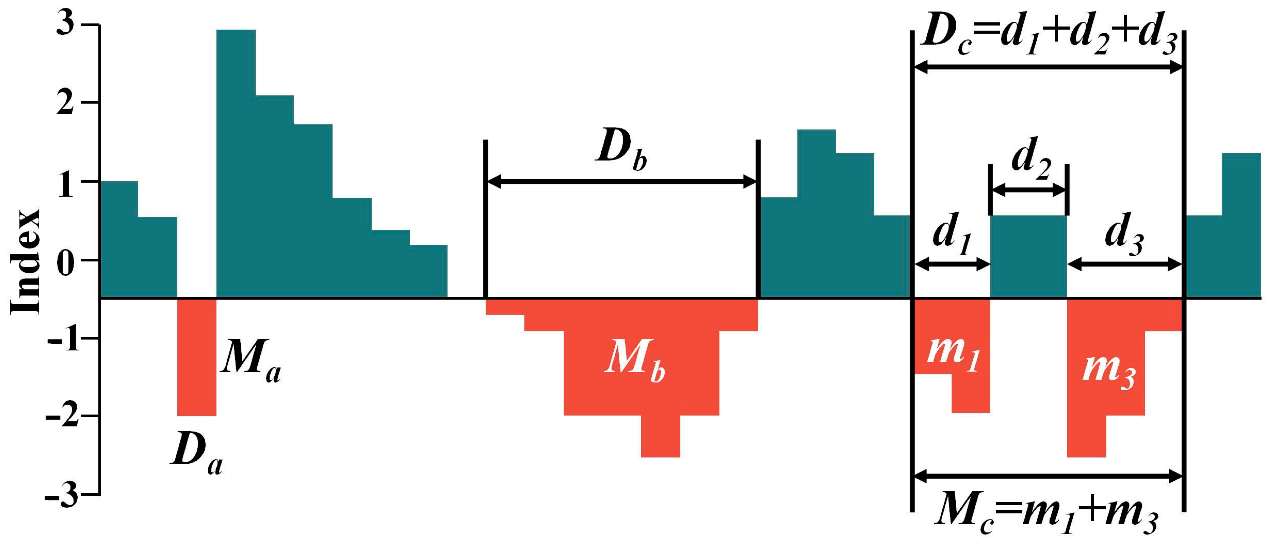
Linear regression was applied to the ENSO index to assess the time lag and cumulative effects of the drought index on the ENSO index. The calculation formula is as follows:
I n d e x t = b × j = 0 n E N S O t m j + a
where a and b are regression coefficients, and E N S O t m j represents the ENSO index at the t -th 10-day scale with a lag of m 10-day scales and a cumulative period of n 10-day scales. According to previous related studies in the field of hydrometeorology, the time lag and cumulative effects typically range from 0 to 36 10-day scales. By permuting and combining m and n , the following four scenarios are considered: when m = 0 and n = 0 , there is no time effect; when 1 < m < 36 and n = 0 , only the lag effect is considered; when m = 0 and 1 < n < 36 , only the time cumulative effect is considered; when 1 < m < 36 and 1 < n < 36 , both the time-lag effect and the time cumulative effect are considered [44,45].
In this study, the Pearson correlation coefficient (PCC) is used to determine the optimal time effect of the lag and cumulative 10-day scales m , n , and PCC is also employed to quantitatively assess the explanatory power of the ENSO index on the variation of the drought index across three periods. The formula for PCC is as follows:
P C C = i = 1 n I n d e x i I n d e x ¯ E N S O i E N S O ¯ i = 1 n I n d e x i I n d e x ¯ 2 · i = 1 n E N S O i E N S O ¯ 2
where I n d e x i represents the i -th drought index; I n d e x ¯ is the mean value of the drought index; E N S O i is the i -th ENSO index; E N S O ¯ is the mean value of the ENSO index. The range of PCC is 0 to 1, and a value closer to 1 indicates a higher degree of linear correlation.

3.6. Run Theory

This study employs run theory to process three drought indices to identify drought events. Run theory is a method for analyzing time series and serves as the theoretical foundation for quantifying the variability of drought and flood indices. It extracts drought characteristics, including occurrence frequency, duration, and intensity [46]. In drought studies, negative runs (as illustrated by the red segments in Figure 3) are typically the focus, where the length of a negative run is referred to as the drought duration ( D ). The total number of negative runs divided by the study period is the drought occurrence frequency ( F ). Additionally, the drought intensity ( M ) represents the cumulative sum of all values below the truncation level ( X ) from the onset to the end of the drought [47].
Based on drought classification, a truncation level of X = 0.5 is set as the threshold for the drought index. If X < 0.5 and the condition persists for only one continuous period, the drought event during that period is defined as an independent drought event characterized by a duration ( D a ) and intensity ( M a ). If a drought event encompasses multiple consecutive values of X < 0.5 , it is also classified as a drought. For example, D b and its intensity M b represent a single drought event. However, the progression of drought is typically slow. During a drought, temporary precipitation or other factors may lead to “subordinate drought” events (i.e., multiple interrelated but non-independent drought events separated by short non-drought intervals of less than one month, essentially part of the same drought event). In this study, such non-independent drought events are defined as “subordinate droughts”, as shown by d 1 and d 3 in Figure 3. When identifying droughts, the total duration from the initial “subordinate drought” to the final “subordinate drought” is defined as the drought duration ( D c = d 1 + d 2 + d 3 ), and the corresponding intensity is the sum of the values of these “subordinate droughts” ( M c = m 1 + m 2 ).

4. Results and Discussions

4.1. Analysis of the Dry-Wet Trends and Their Driving Forces

4.1.1. Establishment of Comprehensive Drought Index (CDI)

As shown in Figure 4, this study first calculated the 10-day scale SPI and SRI for BZA and SD from 1991 to 2020. Subsequently, a novel drought index, CDI, was constructed based on the copula function. At BZA, there are 191 instances on the 10-day scale where both SPI and SRI are simultaneously less than −0.5, and CDI is also consistently below −0.5 during the same periods. At SD, there are 171 instances on the 10-day scale that meet the condition of both SPI and SRI being less than −0.5 simultaneously, and CDI is also consistently below −0.5 during these same periods. As this paper primarily discusses the correlation between drought events and ENSO, several prominent drought events were selected for further comparison based on the actual drought situations that have occurred in the study area historically. By comparing SPI, SRI, and CDI on the 10-day scale, the advantages of CDI were validated, and the results are presented in Figure 5. As observed in Figure 5, when both SPI and SRI exhibit similar upward or downward trends, CDI also reflects these shared trend characteristics, indicating that CDI retains synchronization with the trends of SPI and SRI. If SPI and SRI simultaneously display extreme values at specific time points, CDI often exhibits corresponding extreme values, demonstrating that CDI can capture the tail dependence between SPI and SRI. In most cases, when the SPI rises, and the SRI falls, the CDI increases, but its slope is much smaller than that of the SPI, indicating that the CDI combines both types of drought indices, SPI and SRI.
The CDI preserves the marginal distribution features of SPI and SRI individually while simultaneously extracting and reorganizing the dependence between SPI and SRI. By observing the Pearson correlation coefficients among various drought indices throughout the entire period (Table 4), it can be seen that the constructed CDI has strong correlations with both SPI and SRI. The studies by Faiz et al. [48] and Waseem et al. [49] have demonstrated the advantages of CDI, which is consistent with the findings of this research. Furthermore, Villatoro et al. [50] revealed that high-precision data can more accurately capture the short-term variations in runoff and soil erosion.

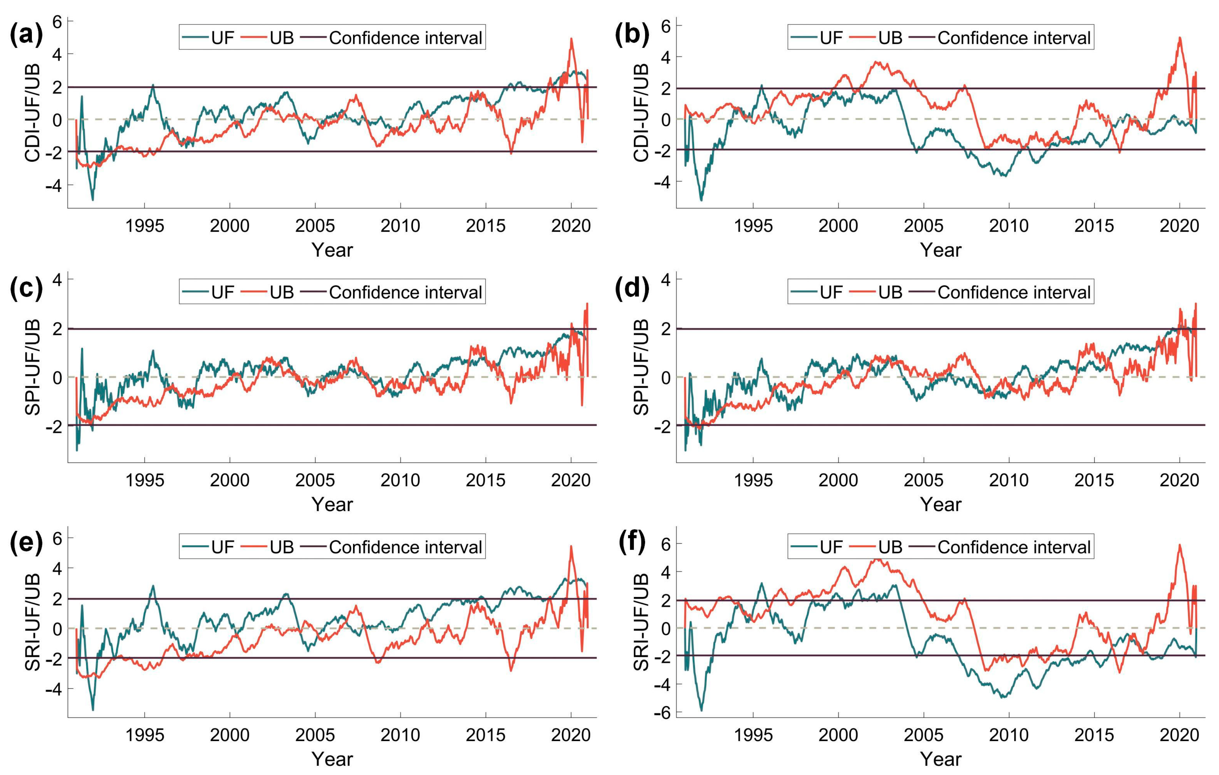
4.1.2. Trends and Mutation in Drought Index

The univariate linear regression method calculated the univariate equations for the BZA and SD drought indices at the 10-day scale. Based on the trend lines in Figure 4, it is evident that the CDI, SPI, and SRI for BZA all exhibit an upward trend, while the CDI and SRI for SD show a downward trend, and the SPI for SD displays an upward trend. Using the Mann–Kendall (MK) trend analysis method, the S and Z M K for the drought index were calculated (Table 5). The analysis reveals that for BZA, the CDI demonstrates a significant upward trend, whereas the SPI and SRI show no clear trend ( S = 0 ). For SD, the CDI exhibits no distinct trend ( S = 0 ), the SPI shows a slight upward trend, and the SRI displays a significant downward trend.
Based on the MK mutation test method, mutation diagrams of the drought indices for BZA and SD were constructed at the 10-day scale to identify mutation points within the study period (Figure 6). The CDI, SPI, and SRI sequences at the BZA station exhibit similar statistical characteristics to the SPI sequence at the SD station. The UF statistic curve is generally above the 0 line and shows a fluctuating upward trend along with the UB curve, indicating a significant increasing trend in the aforementioned drought indices during the study period. It is noteworthy that the intersection points of the UF and UB curves for each index at both stations do not exceed the confidence interval threshold, suggesting an overall continuous characteristic of the trend change. However, a significant uplift in the UB curve in 2019, coupled with the UF curve exceeding the upper confidence limit during this period, indicates a notable abrupt change in the drought trend for that year. The CDI and SRI sequences at the SD station exhibit different variation characteristics. The UF statistic fluctuates alternately above and below the 0 line, showing no significant trend overall. However, the UB curve experienced two sustained super-threshold fluctuations in 2003 and 2019: in 2003, the UB values consistently remained above the upper confidence limit, with the corresponding UF curve located above the 0 line, indicating a short-term abrupt increase in drought severity during this period; in 2019, the UB values exceeded the lower confidence limit, accompanied by the UF curve dropping below the 0 line, reflecting an abrupt response toward wetting during this period.
The increasing trend (BZA) and decreasing trend (SD) of CDI in the Jiaojiang River Basin reflect the spatial heterogeneity of regional wet-dry evolution. Similarly, Zhu et al. [51] highlighted that ENSO events significantly influence the hydrological stability of river basins by altering precipitation and vegetation coverage, potentially leading to regional differentiation in drought indices.

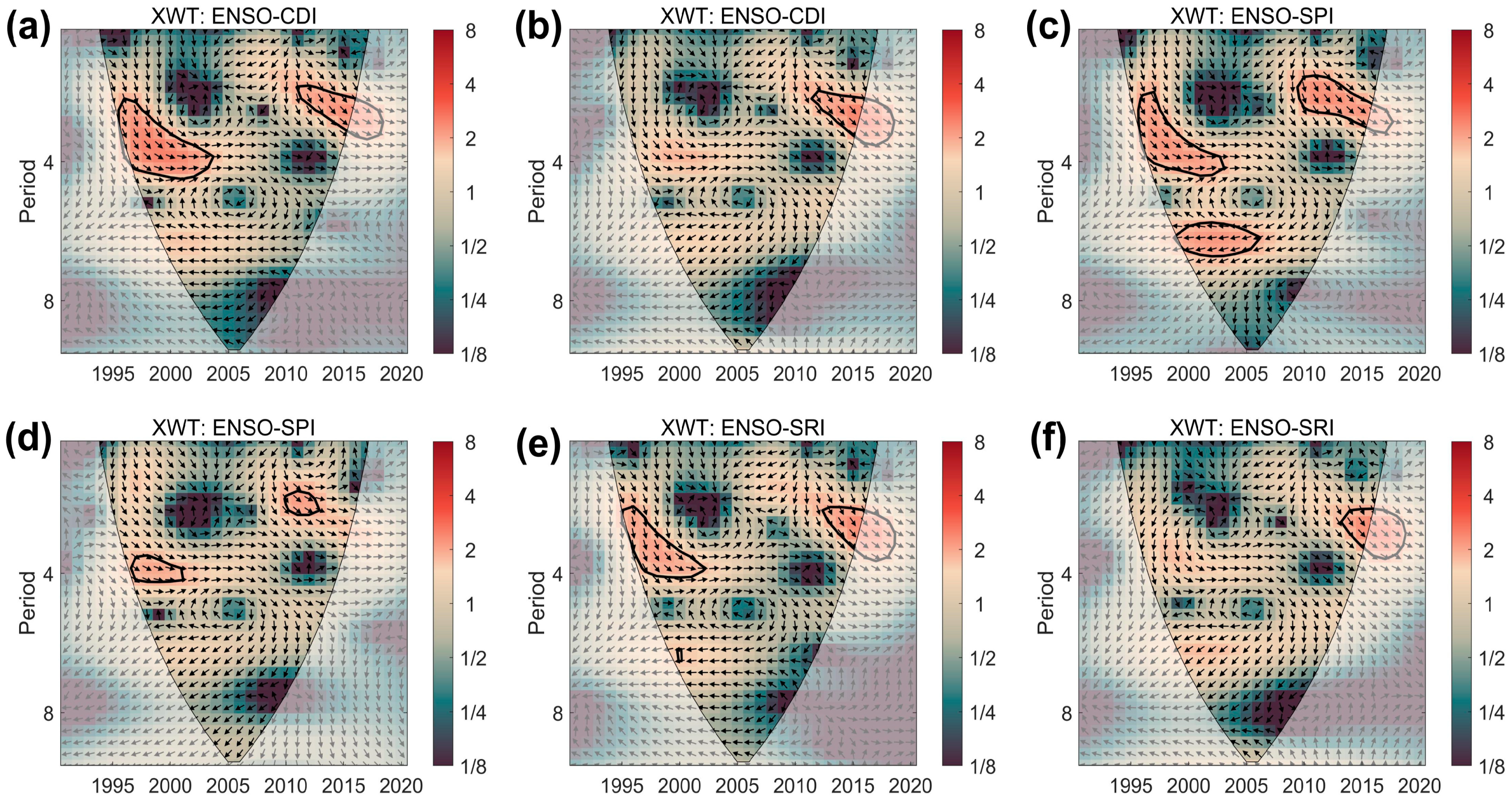
4.1.3. Correlation Analysis Based on Wavelet Analysis

Wavelet analysis was conducted on the drought indices of BZA and SD and the ENSO index, and the continuous wavelet spectra of the drought indices and the ENSO index are shown in Figure 7. As observed in Figure 7, the significance of the 3–4-year, 4-year, and 4–6-year cycles is relatively high for both BZA and SD. Specifically, the three significant cycles of the drought indices for BZA closely align with the three significant cycles of the ENSO index, indicating that the intensity of the drought indices and ENSO events is consistent in both the time and frequency domains. For SD, the 4-year cycle (2002–2006) of the three drought indices also shows a high degree of alignment with the 4-year cycle (2000–2005) of the ENSO index during the same period, and the years around this significant cycle for the ENSO index fall within a high-energy region. In summary, the drought indices of both basins exhibit a certain degree of response relationship with the intensity of ENSO events.
Although continuous wavelet transform is adequate for signal coupling and resolution, it lacks detailed analysis in low-energy regions. Therefore, it is necessary to combine it with the cross-wavelet energy spectrum (Figure 8) for further analysis. As shown in Figure 8, the drought indices of BZA exhibit three significant resonance cycles: a 3-year cycle (2012–2018) showing a positive correlation with similar phase differences, a 3–4-year cycle (1997–2003) also showing a positive correlation with similar phase differences, and a 6-year cycle (1999–2005) showing a negative correlation with opposite phase differences. Similarly, the drought indices of SD display three significant resonance cycles: a 3-year cycle (2010–2015) and a 3–4-year cycle (1996–2003) showing positive correlations, and a 6-year cycle (1999–2005) showing a negative correlation. Within these cycles, several high-energy regions indicate strong correlations between the drought and ENSO indexes during different periods.
The wavelet coherence spectrum can measure the degree of local correlation between two time series in the time-frequency space. The wavelet coherence spectrum was used for analysis (Figure 9). Figure 9 shows two types of cycle components with significant correlations: short cycles within 4 years and long cycles around 8 years. The short cycles exhibit short durations and high frequency of occurrence, while the long cycles have extended durations. Both types of cycles show strong and stable correlations. Based on the direction of the arrows, the short cycles display positive correlations, while the long cycles exhibit negative correlations. The absence of gaps in long and short cycles in specific years confirms the strong correlation between drought indices and ENSO indexes across different periods.
Wavelet analysis reveals a significant resonance period of 3–6 years between the drought index in the Jiaojiang River Basin and ENSO, which is consistent with the findings of Wang et al. [52] in the Yellow River Basin. Furthermore, the analysis by Fan et al. [53] confirms that the instability of river discharge during ENSO years is generally elevated in the circum-Pacific region and is closely associated with precipitation anomalies and ENSO variations, supporting the mechanistic interpretation in the wavelet coherence spectrum of this study.

4.2. Comprehensive Analysis of Drought Across Different Periods

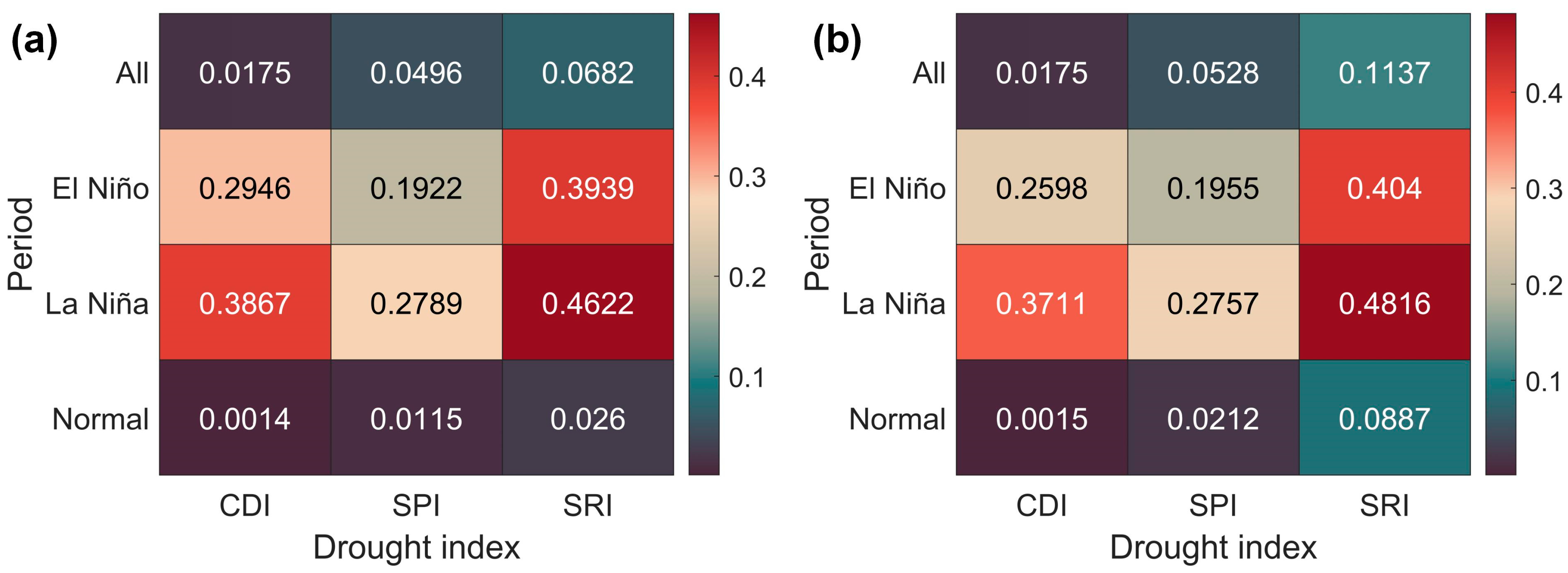
4.2.1. Differences in Drought Indices Across Different Periods

To better analyze the response relationship of the drought indices in the Jiaojiang River Basin to ENSO events, a comparative analysis of the three drought indices (CDI, SPI, and SRI) for BZA and SD during El Niño, La Niña, and normal periods were conducted (Figure 10, Table 6). By analyzing Figure 10 and Table 6, it is evident that, in terms of mean values, the CDI for BZA is highest during the El Niño period (−0.388) and lowest during the La Niña period (−0.601), with SPI and SRI showing similar patterns. The situation for SD is consistent with BZA, as the CDI, SPI, and SRI during the El Niño period are higher than those during the other two periods, while the CDI, SPI, and SRI during the La Niña period are lower than those during the other two periods. This indicates that both basins are relatively wet during El Niño and relatively dry during La Niña. During the La Niña period, the SPI at two stations reaches its maximum, while the SRI attains both its maximum and minimum extremes. This indicates that the degrees of extreme meteorological wetness, extreme hydrological wetness, and extreme hydrological drought are most significantly influenced by La Niña events.
Regarding data dispersion, the standard deviation of the CDI for BZA during the La Niña period (0.954) and the normal period (0.959) are similar and both lower than that during the El Niño period (1.019). The standard deviations and variances of the SPI and SRI for BZA are also highest during the El Niño period and significantly higher during the La Niña period than the normal period. For SD, all three drought indices’ standard deviations and variances are highest during the El Niño period and lowest during the normal period. This indicates that the drought indices exhibit more significant fluctuations and higher data dispersion during El Niño and La Niña periods, while fluctuations are smaller during normal periods. In summary, the drought characteristics of the Jiaojiang River Basin are strongly associated with the types of ENSO events.
The characteristics of wet conditions during El Niño and dry conditions during La Niña align with the findings from studies in the Yellow River Basin, where Wang et al. [54] observed that the cold phase of ENSO (La Niña) leads to a significant decline in the SPEI index, exacerbating drought risks. In this study, drought duration during La Niña periods is notably longer, which may be attributed to the dual influence of oceanic thermal anomalies on coastal regions. For instance, ENSO-driven anomalies in the western Pacific subtropical high can reorganize precipitation patterns along the East Asian coast, a mechanism also highlighted in the research by Piao et al. [55].

4.2.2. Time Lag and Cumulative Effects

The data were divided into El Niño periods, La Niña periods, normal periods, and the entire period, and the PCC between the three drought indices of BZA and SD and the ENSO index during each period was calculated (Figure 11). Analysis of Figure 11 reveals that the influence of the ENSO index on BZA and SD is similar, with no significant correlation between the drought indices and the intensity of the ENSO index during the entire period and normal conditions for both stations. During the El Niño period, all three drought indices of BZA and SD show a significant positive correlation with the ENSO index, with the SRI exhibiting the highest correlation values of 0.3939 and 0.4040 for the two stations, respectively. During the La Niña period, the drought indices of BZA and SD also show a strong positive correlation with the ENSO index, with the SRI again displaying the highest correlation values of 0.4622 and 0.4816 for the two stations, respectively. Numerically, the correlation coefficients between the drought indices and the ENSO index during the El Niño and La Niña periods are significantly higher than those during the normal and entire periods. This indicates that the influence of ENSO events on the wetness and dryness variations in the Jiaojiang River Basin is more pronounced during the El Niño and La Niña periods.
Further research reveals that the time effects of the ENSO index on the variations of the drought indices change depending on the period (Table 7). During the El Niño, La Niña, and normal periods, the ENSO index primarily exerts both time-lag and cumulative effects on the three drought indices. Additionally, during the El Niño period, the ENSO index focuses on producing a single time-lag effect, while the La Niña period emphasizes a single cumulative effect.
The performance of the time lag and cumulative effects of the drought indices on the ENSO index during the El Niño and La Niña periods was separately analyzed (Table 8). This study briefly summarizes the time lag and cumulative effects as follows. For both BZA and SD stations, during the El Niño period, the drought indices generally exhibit a lag of (19 ± 11) 10-day scales (mean ± standard deviation) and a cumulative effect of (15 ± 10) 10-day scales. During the La Niña period, the drought indices generally show a lag of (11 ± 10) 10-day scales and a cumulative effect of (11 ± 9) 10-day scales. During the normal period, the drought indices generally demonstrate a lag of (14 ± 9) 10-day scales and a cumulative effect of (12 ± 9) 10-day scales. In practical applications, it is necessary to consider the range of uncertainty in lag time, which is crucial for designing flexible disaster response strategies.

4.2.3. Identification of Drought Events Across Different Periods

Using run theory, drought events within the study period were identified, and drought characteristics were statistically analyzed (Table 9). Analysis of Table 9 reveals that during different ENSO events, the CDI, SPI, and SRI drought indices for the BZA and SD basins exhibit distinct characteristics. Regarding drought indices, the number of drought events identified based on SPI in both basins is significantly higher than those identified based on CDI and SRI, indicating that meteorological droughts occur more frequently than hydrological droughts. This may be due to the immediacy, rapidity, and uncontrollability of meteorological drought, whereas hydrological drought exhibits system complexity and room for human intervention. Due to the different periods of each period, the number of events cannot directly reflect the frequency of events. Therefore, this study eliminates the influence of time length through probability to ensure the fairness and science of the comparison. In terms of drought event types, during El Niño and La Niña periods, the probability of subordinate drought is higher than that of independent drought, indicating that ENSO events cause frequent fluctuations in the wetness and dryness conditions of the two basins. In terms of drought severity, the probability of severe and extreme droughts during ENSO events, particularly the La Niña period, is much higher than during the normal period, indicating that El Niño and La Niña increase the likelihood of extreme droughts in both basins.
Regarding drought intensity and duration, the average drought intensity values for CDI, SPI, and SRI in both basins during the La Niña period are lower than those during the El Niño and the normal periods. The maximum average drought duration (17.18 10-day scales) occurs during the La Niña period, and the average drought duration during this period is significantly longer than during other periods. This indicates that drought intensity increases and duration extends during the La Niña period. In contrast, the average drought intensity and duration during the El Niño period show no significant difference compared to the normal period.
The increased frequency of extreme droughts during the La Niña period is consistent with findings from studies across multiple global regions. For example, Yue et al. [56] found that the probability of summer droughts in Northeast China significantly rises during the cold phase of ENSO, while Tozer et al. [57] demonstrated that drought early warning models also identify ENSO as a key driver in the transmission of drought risks.

4.3. The Application Prospects and Limitations of the Research

The Jiaojiang River basin, as a composite economic zone of manufacturing and agriculture along the eastern coast of China, experiences drought events that have significant ripple effects on social development. Drought leads to crop yield reductions and agricultural failures, impacting the agricultural economy. For instance, in August 2022, the Jiaojiang City Water Resources Bureau issued a yellow drought warning stating that precipitation over the past 60 days was 86% less than the historical average, resulting in reduced irrigation water for agriculture and crop stress. During the drought season, the city’s daily water supply increased by about 30% compared to normal, yet reservoir storage decreased by nearly 50%, exerting unprecedented pressure on the water supply. Drought exacerbates grassland degradation and desertification, affecting the quality and market supply of livestock products. It also impacts tourist attractions by drying up water sources and withering vegetation, diminishing the tourist experience.
This study supports three-tiered policy responses: (1) at the short-term emergency level, implementing graded water restrictions triggered by dynamic 10-day CDI thresholds; (2) at the medium-term planning level, optimizing the joint operation scheme of reservoir groups based on the correlation between ENSO phases and drought duration; (3) at the long-term adaptation level, adjusting the spatial layout of coastal industrial zones and ecological protection areas in accordance with the spatial response patterns of drought.
The limitations of this study include the following:
(1)
This study focuses solely on the Jiaojiang River Basin in southeastern China as the research area. Although the Jiaojiang River Basin is representative, coastal basins differ in geographical environment, climatic conditions, and underlying surface characteristics. In the future, multiple coastal basins in different geographical locations will be selected for research to compare the similarities and differences in drought evolution responses to ENSO across regions.
(2)
The data used in this study span from 1991 to 2020, which is relatively short. In the future, meteorological and hydrological data over a longer period will be collected to explore the long-term trends in the relationship between ENSO and drought evolution, providing a more robust data foundation for predicting future drought trends.
(3)
Although the constructed CDI has advantages, it only considers two indicators, SPI and SRI, and does not include other factors that may influence droughts, such as temperature changes, soil moisture, and vegetation coverage. In the future, more variables affecting droughts will be incorporated to optimize the composite drought index model, enabling a more comprehensive and accurate characterization of drought features.

5. Conclusions

This study focuses on the Jiaojiang River Basin in southeastern China, providing an in-depth exploration of the response mechanisms of drought evolution to the ENSO in coastal regions. By analyzing 10-day scale meteorological and hydrological data from 1991 to 2020 and employing methods such as the Mann–Kendall trend and mutation test, wavelet analysis, PCC, and run theory, this study has reached the following three key conclusions:
(1)
The CDI constructed using 10-day scale data effectively integrates the advantages of SPI and SRI, accurately reflecting the combined characteristics of meteorological and hydrological droughts in the basin. This demonstrates that 10-day scale data can finely capture short-term variations in drought features, providing more precise information for drought monitoring and assessment.
(2)
Wavelet analysis based on 10-day scale data reveals a high degree of alignment between the significant cycles of the drought indices in the Jiaojiang River Basin and ENSO events, indicating a strong response relationship. Moreover, this influence varies across different time scales. This highlights the ability of 10-day scale data to more precisely characterize the dynamic associations between drought indices and ENSO events at various time scales.
(3)
Analysis using 10-day scale data shows significant differences in drought characteristics of the Jiaojiang River Basin during different ENSO periods. The influence of ENSO on wet-dry variations in the basin is particularly strong during El Niño and La Niña periods. This underscores the advantage of 10-day scale data in revealing short-term changes and extreme conditions of drought events.
This study, based on high-precision data, reveals the response mechanisms of drought in small and medium-sized coastal basins to ENSO events, providing a scientific basis for constructing a climate-resilient water resource management system and formulating disaster early warning plans based on ecological carrying capacity. The research findings can effectively balance flood control, drought relief, and ecological protection in coastal regions, offering decision-making support for implementing integrated coastal zone management strategies that consider both disaster prevention and mitigation, as well as sustainable development.

Author Contributions

Conceptualization, H.Q. and H.C.; methodology, Y.C.; software, C.X.; validation, Y.G.; formal analysis, H.N.; investigation, H.C.; resources, S.H.; data curation, H.Q.; writing—original draft preparation, H.Q.; writing—review and editing, H.C.; visualization, H.X.; supervision, H.C.; project administration, H.C.; funding acquisition, H.C. All authors have read and agreed to the published version of the manuscript.

Funding

This research was funded by the Zhejiang Provincial Natural Science Foundation, grant numbers ZCLQ24E0901, LGEY25E090012, and LZJWY22E090007; the Scientific Research Fund of Zhejiang Provincial Education Department, grant number Y202352492; the Huzhou Science and Technology Plan Project, grant number 2023GZ64; and the Nanxun Scholars Program for Young Scholars of ZJWEU, grant number RC2022021137.

Institutional Review Board Statement

Not applicable.

Informed Consent Statement

Not applicable.

Data Availability Statement

The data presented in this study are available on request from the corresponding author.

Acknowledgments

We thank the Zhejiang Hydrological Management Center for providing hydrological and meteorological data.

Conflicts of Interest

The authors declare no conflicts of interest.

References

  1. Rezaei, A. Ocean-Atmosphere Circulation Controls on Integrated Meteorological and Agricultural Drought over Iran. J. Hydrol. 2021, 603, 126928. [Google Scholar] [CrossRef]
  2. Gan, R.; Li, D.; Chen, C.; Yang, F.; Ma, X. Impacts of Climate Change on Extreme Precipitation in the Upstream of Chushandian Reservoir, China. Hydrol. Res. 2022, 53, 504–518. [Google Scholar] [CrossRef]
  3. Zhou, L.; Wang, S.; Du, M.; Chen, Q.; He, C.; Zhang, J.; Zhu, Y.; Gong, Y. The Influence of ENSO and MJO on Drought in Different Ecological Geographic Regions in China. Remote Sens. 2021, 13, 875. [Google Scholar] [CrossRef]
  4. Yang, B.; Kong, L.; Lai, C.; Huang, D.; Cheng, X. A Framework on Analyzing Long-Term Drought Changes and Its Influential Factors Based on the PDSI. Atmosphere 2022, 13, 1151. [Google Scholar] [CrossRef]
  5. Yan, Y.; Mao, K.; Shen, X.; Cao, M.; Xu, T.; Guo, Z.; Bao, Q. Evaluation of the Influence of ENSO on Tropical Vegetation in Long Time Series Using a New Indicator. Ecol. Indic. 2021, 129, 107872. [Google Scholar] [CrossRef]
  6. Sun, B.; Wang, H.; Li, H.; Zhou, B.; Duan, M.; Li, H. A Long-Lasting Precipitation Deficit in South China During Autumn-Winter 2020/2021: Combined Effect of ENSO and Arctic Sea Ice. J. Geophys. Res. Atmos. 2022, 127, e2021JD035584. [Google Scholar] [CrossRef]
  7. Xing, Z.; Wei, J.; Li, Y.; Zhang, X.; Ma, M.; Yi, P.; Ju, Q.; Laux, P.; Kunstmann, H. Disentangling the Spatially Combined and Temporally Lagged Influences of Climate Oscillations on Seasonal Droughts in the East Asian Monsoon Influenced Poyang Lake Basin. Atmos. Res. 2024, 310, 107603. [Google Scholar] [CrossRef]
  8. Wongchuig, S.; Kitambo, B.; Papa, F.; Paris, A.; Fleischmann, A.S.; Gal, L.; Boucharel, J.; Paiva, R.; Oliveira, R.J.; Tshimanga, R.M.; et al. Improved Modeling of Congo’s Hydrology for Floods and Droughts Analysis and ENSO Teleconnections. J. Hydrol. Reg. Stud. 2023, 50, 101563. [Google Scholar] [CrossRef]
  9. Nurdiati, S.; Sopaheluwakan, A.; Septiawan, P. Joint Pattern Analysis of Forest Fire and Drought Indicators in Southeast Asia Associated with ENSO and IOD. Atmosphere 2022, 13, 1198. [Google Scholar] [CrossRef]
  10. Wei, W.; Zhang, J.; Zhou, L.; Xie, B.; Zhou, J.; Li, C. Comparative Evaluation of Drought Indices for Monitoring Drought Based on Remote Sensing Data. Environ. Sci. Pollut. Res. 2021, 28, 20408–20425. [Google Scholar] [CrossRef]
  11. Zhu, Z.; Duan, W.; Zou, S.; Zeng, Z.; Chen, Y.; Feng, M.; Qin, J.; Liu, Y. Spatiotemporal Characteristics of Meteorological Drought Events in 34 Major Global River Basins during 1901–2021. Sci. Total Environ. 2024, 921, 170913. [Google Scholar] [CrossRef] [PubMed]
  12. Uddin, M.J.; Hu, J.; Islam, A.R.M.T.; Eibek, K.U.; Nasrin, Z.M. A Comprehensive Statistical Assessment of Drought Indices to Monitor Drought Status in Bangladesh. Arab. J. Geosci. 2020, 13, 323. [Google Scholar] [CrossRef]
  13. Vilanova, R.S.; Delgado, R.C.; Frossard De Andrade, C.; Lopes Dos Santos, G.; Magistrali, I.C.; Moreira De Oliveira, C.M.; Teodoro, P.E.; Capristo Silva, G.F.; Silva Junior, C.A.D.; De Ávila Rodrigues, R. Vegetation Degradation in ENSO Events: Drought Assessment, Soil Use and Vegetation Evapotranspiration in the Western Brazilian Amazon. Remote Sens. Appl. Soc. Environ. 2021, 23, 100531. [Google Scholar] [CrossRef]
  14. Ullah, I.; Ma, X.; Ren, G.; Yin, J.; Iyakaremye, V.; Syed, S.; Lu, K.; Xing, Y.; Singh, V.P. Recent Changes in Drought Events over South Asia and Their Possible Linkages with Climatic and Dynamic Factors. Remote Sens. 2022, 14, 3219. [Google Scholar] [CrossRef]
  15. Toledo, N.; Moulatlet, G.; Gaona, G.; Valencia, B.; Hirata, R.; Conicelli, B. Dynamics of Meteorological and Hydrological Drought: The Impact of Groundwater and El Niño Events on Forest Fires in the Amazon. Sci. Total Environ. 2024, 954, 176612. [Google Scholar] [CrossRef]
  16. Zhang, J.; Zhang, X.; Li, H.; Fan, Y.; Meng, Z.; Liu, D.; Pan, S. Optimization of Water Quantity Allocation in Multi-Source Urban Water Supply Systems Using Graph Theory. Water 2025, 17, 61. [Google Scholar] [CrossRef]
  17. Sun, H.; Liu, X.; Mao, X.; Jia, W.; Herzschuh, U. Centennial-Scale Variability of the Indian Summer Monsoon during the Middle to Late Holocene and Its Links with ENSO Activity. Palaeogeogr. Palaeoclimatol. Palaeoecol. 2023, 612, 111380. [Google Scholar] [CrossRef]
  18. Abdelkader, M.; Yerdelen, C. Hydrological Drought Variability and Its Teleconnections with Climate Indices. J. Hydrol. 2022, 605, 127290. [Google Scholar] [CrossRef]
  19. Suhana, L.; Tan, M.L.; Luhaim, Z.; Ramli, M.H.P.; Subki, N.S.; Tangang, F.; Ishak, A.M. Spatiotemporal Characteristics of Hydrometeorological Droughts and Their Connections to Large-Scale Atmospheric Circulations in the Kelantan River Basin, Malaysia. Water Supply 2023, 23, 2283–2298. [Google Scholar] [CrossRef]
  20. Gimenez, B.O.; Souza, D.C.; Higuchi, N.; Negrón-Juárez, R.I.; Sampaio-Filho, I.D.J.; Araújo, A.C.; Lima, A.J.N.; Fontes, C.G.; Jardine, K.J.; Koven, C.D.; et al. Hysteresis Area at the Canopy Level during and after a Drought Event in the Central Amazon. Agric. For. Meteorol. 2024, 353, 110052. [Google Scholar] [CrossRef]
  21. Dixit, S.; Jayakumar, K.V. A Study on Copula-Based Bivariate and Trivariate Drought Assessment in Godavari River Basin and the Teleconnection of Drought with Large-Scale Climate Indices. Theor. Appl. Climatol. 2021, 146, 1335–1353. [Google Scholar] [CrossRef]
  22. Restrepo-Coupe, N.; O’Donnell Christoffersen, B.; Longo, M.; Alves, L.F.; Campos, K.S.; Da Araujo, A.C.; De Oliveira, R.C.; Prohaska, N.; Da Silva, R.; Tapajos, R.; et al. Asymmetric Response of Amazon Forest Water and Energy Fluxes to Wet and Dry Hydrological Extremes Reveals Onset of a Local Drought-Induced Tipping Point. Glob. Change Biol. 2023, 29, 6077–6092. [Google Scholar] [CrossRef] [PubMed]
  23. Fan, J.; Wei, S.; Liu, D.; Qin, T.; Xu, F.; Wu, C.; Liu, G.; Cheng, Y. Impact of ENSO Events on Meteorological Drought in the Weihe River Basin, China. Front. Earth Sci. 2023, 11, 1093632. [Google Scholar] [CrossRef]
  24. Najib, M.K.; Nurdiati, S.; Sopaheluwakan, A. Copula-Based Joint Distribution Analysis of the ENSO Effect on the Drought Indicators over Borneo Fire-Prone Areas. Model. Earth Syst. Environ. 2022, 8, 2817–2826. [Google Scholar] [CrossRef]
  25. Huang, C.; Durán, S.M.; Hu, K.; Li, H.; Swenson, N.G.; Enquist, B.J. Remotely Sensed Assessment of Increasing Chronic and Episodic Drought Effects on a Costa Rican Tropical Dry Forest. Ecosphere 2021, 12, e03824. [Google Scholar] [CrossRef]
  26. Nguyen, T.-T.-H.; Li, M.-H.; Vu, T.M.; Chen, P.-Y. Multiple Drought Indices and Their Teleconnections with ENSO in Various Spatiotemporal Scales over the Mekong River Basin. Sci. Total Environ. 2023, 854, 158589. [Google Scholar] [CrossRef]
  27. Alemaw, B.F. The Recent Droughts of 2019/20 in Southern Africa and Its Teleconnection with ENSO Events. Atmos. Clim. Sci. 2022, 12, 246–263. [Google Scholar] [CrossRef]
  28. Hernández-López, J.A.; Puerta-Cortés, D.X.; Andrade, H.J. Predictive Analysis of Adaptation to Drought of Farmers in the Central Zone of Colombia. Sustainability 2024, 16, 7210. [Google Scholar] [CrossRef]
  29. Chen, H.; Huang, S.; Xu, Y.-P.; Teegavarapu, R.S.V.; Guo, Y.; Nie, H.; Xie, H.; Zhang, L. River Ecological Flow Early Warning Forecasting Using Baseflow Separation and Machine Learning in the Jiaojiang River Basin, Southeast China. Sci. Total Environ. 2023, 882, 163571. [Google Scholar] [CrossRef]
  30. Huang, S.; Zhang, H.; Liu, Y.; Liu, W.; Wei, F.; Yang, C.; Ding, F.; Ye, J.; Nie, H.; Du, Y.; et al. Assessment of Hydrological and Meteorological Composite Drought Characteristics Based on Baseflow and Precipitation. Water 2024, 16, 1466. [Google Scholar] [CrossRef]
  31. Liu, Y.; Wen, Y.; Zhao, Y.; Hu, H. Analysis of Drought and Flood Variations on a 200-Year Scale Based on Historical Environmental Information in Western China. Int. J. Environ. Res. Public Health 2022, 19, 2771. [Google Scholar] [CrossRef] [PubMed]
  32. Delcroix, T.; Michel, S.L.L.; Swingedouw, D.; Malaizé, B.; Daniau, A.-L.; Abarca-del-Rio, R.; Caley, T.; Sémah, A.-M. Clarifying the Role of ENSO on Easter Island Precipitation Changes: Potential Environmental Implications for the Last Millennium. Paleoceanogr. Paleoclimatology 2022, 37, e2022PA004514. [Google Scholar] [CrossRef]
  33. Gutierrez-Villarreal, R.A.; Espinoza, J.-C.; Lavado-Casimiro, W.; Junquas, C.; Molina-Carpio, J.; Condom, T.; Marengo, J.A. The 2022-23 Drought in the South American Altiplano: ENSO Effects on Moisture Flux in the Western Amazon during the Pre-Wet Season. Weather Clim. Extrem. 2024, 45, 100710. [Google Scholar] [CrossRef]
  34. Zhao, Q.; Liu, K.; Li, Z.; Liu, Y.; Yao, Y. A Novel ENSO Monitoring Index and Its Potential for Drought Application. J. Atmos. Sol. Terr. Phys. 2021, 225, 105762. [Google Scholar] [CrossRef]
  35. Afshar, M.H.; Bulut, B.; Duzenli, E.; Amjad, M.; Yilmaz, M.T. Global Spatiotemporal Consistency between Meteorological and Soil Moisture Drought Indices. Agric. For. Meteorol. 2022, 316, 108848. [Google Scholar] [CrossRef]
  36. Salimi, H.; Asadi, E.; Darbandi, S. Meteorological and Hydrological Drought Monitoring Using Several Drought Indices. Appl. Water Sci. 2021, 11, 11. [Google Scholar] [CrossRef]
  37. Muthuvel, D.; Amai, M. Multivariate Analysis of Concurrent Droughts and Their Effects on Kharif Crops-A Copula-Based Approach. Int. J. Climatol. 2022, 42, 2773–2794. [Google Scholar] [CrossRef]
  38. Perez Arango, J.D.; Lintner, B.R.; Carvalho, L.M.V.; Lyon, B. Spatial Extents of Tropical Droughts During El Niño in Current and Future Climate in Observations, Reanalysis, and CMIP5 Models. Geophys. Res. Lett. 2021, 48, e2021GL093701. [Google Scholar] [CrossRef]
  39. Chen, H.; Xu, B.; Qiu, H.; Huang, S.; Teegavarapu, R.S.V.; Xu, Y.-P.; Guo, Y.; Nie, H.; Xie, H. Adaptive assessment of reservoir scheduling to hydrometeorological comprehensive dry and wet condition evolution in a multi-reservoir region of southeastern China. J. Hydrol. 2025, 648, 132392. [Google Scholar] [CrossRef]
  40. Xu, Y.; Zhu, X.; Cheng, X.; Gun, Z.; Lin, J.; Zhao, J.; Yao, L.; Zhou, C. Drought Assessment of China in 2002–2017 Based on a Comprehensive Drought Index. Agric. For. Meteorol. 2022, 319, 108922. [Google Scholar] [CrossRef]
  41. Ma, Y.; Sun, J.; Dong, T.; Yu, W.; Dong, W. More Profound Impact of CP ENSO on Australian Spring Rainfall in Recent Decades. Clim. Dyn. 2023, 60, 3065–3079. [Google Scholar] [CrossRef]
  42. Coughlan De Perez, E.; Anderson, W.; Han, E.; Masukwedza, G.I.T.; Mphonyane, N. Detectable Use of ENSO Information on Crop Production in Southern Africa. Clim. Serv. 2024, 36, 100514. [Google Scholar] [CrossRef] [PubMed]
  43. Nguyen, P.; Min, S.; Kim, Y. Combined Impacts of the El Niño-Southern Oscillation and Pacific Decadal Oscillation on Global Droughts Assessed Using the Standardized Precipitation Evapotranspiration Index. Int. J. Climatol. 2021, 41, E1645–E1662. [Google Scholar] [CrossRef]
  44. Henchiri, M.; Igbawua, T.; Javed, T.; Bai, Y.; Zhang, S.; Essifi, B.; Ujoh, F.; Zhang, J. Meteorological Drought Analysis and Return Periods over North and West Africa and Linkage with El Niño–Southern Oscillation (ENSO). Remote Sens. 2021, 13, 4730. [Google Scholar] [CrossRef]
  45. Chen, H.; Huang, S.; Xu, Y.-P.; Teegavarapu, R.S.V.; Guo, Y.; Nie, H.; Xie, H. Using Baseflow Ensembles for Hydrologic Hysteresis Characterization in Humid Basins of Southeastern China. Water Resour. Res. 2024, 60, e2023WR036195. [Google Scholar] [CrossRef]
  46. Singh, J.; Ashfaq, M.; Skinner, C.B.; Anderson, W.B.; Mishra, V.; Singh, D. Enhanced Risk of Concurrent Regional Droughts with Increased ENSO Variability and Warming. Nat. Clim. Change 2022, 12, 163–170. [Google Scholar] [CrossRef]
  47. Higgins, P.A.; Palmer, J.G.; Andersen, M.S.; Turney, C.S.M.; Johnson, F. Extreme Events in the Multi-Proxy South Pacific Drought Atlas. Clim. Change 2023, 176, 105. [Google Scholar] [CrossRef]
  48. Faiz, M.A.; Zhang, Y.; Zhang, X.; Ma, N.; Aryal, S.K.; Ha, T.T.V.; Baig, F.; Naz, F. A Composite Drought Index Developed for Detecting Large-Scale Drought Characteristics. J. Hydrol. 2022, 605, 127308. [Google Scholar] [CrossRef]
  49. Waseem, M.; Ajmal, M.; Kim, T.-W. Development of a New Composite Drought Index for Multivariate Drought Assessment. J. Hydrol. 2015, 527, 30–37. [Google Scholar] [CrossRef]
  50. Villatoro-Sánchez, M.; Le Bissonnais, Y.; Moussa, R.; Rapidel, B. Temporal Dynamics of Runoff and Soil Loss on a Plot Scale under a Coffee Plantation on Steep Soil (Ultisol), Costa Rica. J. Hydrol. 2015, 523, 409–426. [Google Scholar] [CrossRef]
  51. Zhu, M.; Yu, D.; Yu, Y.; Zheng, Y.; Li, S.; Cai, X.; Chen, N. ENSO Enhances Seasonal River Discharge Instability and Water Resource Allocation Pressure. Water Resour. Res. 2025, 61, e2023WR036965. [Google Scholar] [CrossRef]
  52. Wang, M.; Chen, Y.; Li, J.; Zhao, Y. Spatiotemporal Evolution and Driving Force Analysis of Drought Characteristics in the Yellow River Basin. Ecol. Indic. 2025, 170, 113007. [Google Scholar] [CrossRef]
  53. Fan, F.; Lin, R.; Fang, X.; Xue, F.; Zheng, F.; Zhu, J. Influence of the Eastern Pacific and Central Pacific Types of ENSO on the South Asian Summer Monsoon. Adv. Atmos. Sci. 2021, 38, 12–28. [Google Scholar] [CrossRef]
  54. Wang, Y.; Wang, S.; Zhao, W.; Liu, Y. The Increasing Contribution of Potential Evapotranspiration to Severe Droughts in the Yellow River Basin. J. Hydrol. 2022, 605, 127310. [Google Scholar] [CrossRef]
  55. Piao, J.; Chen, W.; Chen, S.; Gong, H.; Chen, X.; Liu, B. The Intensified Impact of El Niño on Late-Summer Precipitation over East Asia since the Early 1990s. Clim. Dyn. 2020, 54, 4793–4809. [Google Scholar] [CrossRef]
  56. Yue, Y.; Liu, H.; Mu, X.; Qin, M.; Wang, T.; Wang, Q.; Yan, Y. Spatial and Temporal Characteristics of Drought and Its Correlation with Climate Indices in Northeast China. PLoS ONE 2021, 16, e0259774. [Google Scholar] [CrossRef]
  57. Tozer, C.R.; Risbey, J.S.; Monselesan, D.P.; Pook, M.J.; Irving, D.; Ramesh, N.; Reddy, J.; Squire, D.T. Impacts of ENSO on Australian Rainfall: What Not to Expect. J. South. Hemisph. Earth Syst. Sci. 2023, 73, 77–81. [Google Scholar] [CrossRef]
Figure 1. Geographical location map of the study area.
Sustainability 17 02616 g001
Figure 2. Research flowchart.
Sustainability 17 02616 g002
Figure 3. Principle of run theory.
Sustainability 17 02616 g003
Figure 4. The 10-day scale drought indices for BZA and SD. (a,c,e) respectively depict the CDI, SPI, and SRI for BZA, while (b,d,f) respectively illustrate the CDI, SPI, and SRI for SD. The boxes highlight partial drought events occurring in the basin.
Sustainability 17 02616 g004
Figure 5. The 10-day scale drought indices for the sub-periods in BZA and SD. (ac) illustrate the drought indices for BZA, while (df) depict the drought indices for SD.
Sustainability 17 02616 g005
Figure 6. The MK mutation test for the 10-day scale drought indices of BZA and SD. (a,c,e) respectively illustrate the CDI, SPI, and SRI for BZA, while (b,d,f) respectively depict the CDI, SPI, and SRI for SD.
Sustainability 17 02616 g006
Figure 7. The continuous wavelet spectra of the drought indices and the ENSO index for BZA and SD. (ac) represent the ENSO index, (df) represent the CDI, SPI, and SRI of BZA respectively, and (gi) represent the CDI, SPI, and SRI of SD respectively.
Sustainability 17 02616 g007
Figure 8. The cross-wavelet spectra of the drought indices and the ENSO index for BZA and SD. (a,c,e) respectively illustrate the CDI, SPI, and SRI for BZA, while (b,d,f) respectively depict the CDI, SPI, and SRI for SD.
Sustainability 17 02616 g008
Figure 9. The wavelet coherence spectra of the drought indices and the ENSO index for BZA and SD. (a,c,e) respectively depict the CDI, SPI, and SRI for BZA, while (b,d,f) respectively illustrate the CDI, SPI, and SRI for SD.
Sustainability 17 02616 g009
Figure 10. The statistical characteristics of the three drought indices for SD and BZA during different periods. In the horizontal axis, the first parameter represents the type of drought index, where C, P, and R denote CDI, SPI, and SRI, respectively. The second parameter indicates the basin, with B and S representing BZA and SD, respectively. The third parameter represents the ENSO condition, where E, L, and N denote El Niño, La Niña, and Normal, respectively. The discrete points beyond the whiskers in the plot represent extreme values exceeding 1.5 times the IQR, reflecting natural extreme variations or low-probability events within the data. These values conform to a reasonable distribution within the context of the study (e.g., extreme weather events) and are not anomalies arising from data collection or processing errors.
Sustainability 17 02616 g010
Figure 11. The correlation levels between the three drought indices and the ENSO index during different periods for BZA and SD. (a) illustrates the PCC for BZA, while (b) depicts the PCC for SD.
Sustainability 17 02616 g011
Table 1. Geographical data for each station.
Sub
-Basin
StationsLongitude
(°E)
Latitude
(°N)
Sub
-Basin
StationsLongitude
(°E)
Latitude
(°N)
Shifeng-xiShaduan (SD)121.06 28.95 Yong’an
-xi
Baizhiao(BZA)120.94 28.88
Caodian (CD)120.40 28.63 Fengshugang (FSG)120.94 29.02
Hengliao (HL)120.48 28.83 Jietou (JT)120.81 29.12
Linshan (LS)120.58 28.67 Lishimen (LSM)120.77 29.03
Longtantou (LTT)120.53 28.57 Tiantai Yanxia (YX)120.93 29.14
Baita (BT)120.60 28.75 Tianzhu (TZ)120.77 29.02
Shangzhang (SZ)120.73 28.67 Baihedian (BHD)120.94 29.24
Xianju (XJ)120.73 28.85 Feishu (FS)121.16 29.12
Xianju Mei’ao (MA)120.80 28.68 Hutanggang (HTG)121.18 29.08
Xiahuitou (XHT)120.83 28.77 Longhuangtang (LHT)121.05 29.24
Xishang (XS)120.85 28.68 Shantouzheng (STZ)120.97 29.06
Miaoliao (ML)120.78 28.62
Table 2. Statistics of El Niño and La Niña events during the research period.
El NiñoLa Niña
Serial NumberStart TimeEnd TimeIntensitySerial NumberStart TimeEnd TimeIntensity
1 1991.51992.6strong1 1995.91996.3weak
2 1994.91995.3weak2 1998.72000.6medium
3 1997.51998.5superstrong3 2000.102001.2weak
4 2002.62003.2medium4 2007.82008.5medium
5 2004.72005.2weak5 2010.62011.5medium
6 2006.92007.1weak6 2011.82012.3weak
7 2009.72010.3medium7 2017.102018.4weak
8 2014.102016.4superstrong8 2020.82020.12medium
9 2018.92019.6weak
Table 3. Classification of dry levels.
ValueDrought Level
1 < I n d e x 0.5 Light drought
1.5 < I n d e x 1 Moderate drought
2 < I n d e x 1.5 Severe drought
I n d e x 2 Extreme drought
Table 4. Pearson correlation coefficients of dry indices across all periods.
StationSPI-CDISRI-CDISPI-SRI
BZA0.89660.85970.5988
SD0.87640.85860.5619
Table 5. Results of the MK trend test.
StationDrought Index S Z M K Trend
BZACDI12.4093Significantly becoming moist
SPI01.6285No significant changes
SRI02.6856No significant changes
SDCDI0−0.8835No significant changes
SPI11.7365Slightly becoming moist
SRI−1−2.0789Significantly becoming drought
Table 6. Differences in Drought Indices Across Different Periods.
IndexStationPeriodMeanMedianMaximumMinimumStandard DeviationVariance
CDIBZAEl Niño−0.388 −0.526 2.296 −2.937 1.019 1.038
La Niña−0.601 −0.760 2.980 −3.058 0.954 0.910
Normal−0.583 −0.650 2.470 −3.376 0.959 0.920
SDEl Niño−0.388 −0.414 2.400 −3.995 1.025 1.050
La Niña−0.623 −0.701 3.009 −2.821 0.978 0.957
Normal−0.600 −0.669 2.582 −3.309 0.965 0.931
SPIBZAEl Niño0.120 0.171 2.380 −2.666 1.007 1.014
La Niña−0.009 −0.050 3.690 −2.462 0.978 0.956
Normal−0.028 0.004 3.175 −2.999 0.974 0.948
SDEl Niño0.144 0.198 2.481 −3.840 1.004 1.008
La Niña−0.026 0.042 3.641 −2.675 0.991 0.982
Normal−0.019 0.022 3.259 −3.054 0.966 0.932
SRIBZAEl Niño0.173 0.025 3.279 −1.770 1.062 1.128
La Niña−0.091 −0.317 3.057 −2.060 1.000 0.999
Normal−0.084 −0.257 3.077 −1.831 0.941 0.885
SDEl Niño0.176 0.026 3.502 −2.281 1.056 1.116
La Niña−0.089 −0.191 3.041 −2.565 0.973 0.946
Normal−0.072 −0.136 3.168 −2.268 0.963 0.926
Table 7. Statistics on the number of time effects of the ENSO index on drought indices across different periods.
PeriodTime EffectBZASD
CDISPISRICDISPISRI
El NiñoNo001001
Lag010011
Accumulation000000
Lag and accumulation988987
La NiñaNo000000
Lag000001
Accumulation111101
Lag and accumulation777786
NormalNo000000
Lag001001
Accumulation010001
Lag and accumulation109910108
Table 8. The overall performance of the time effect of the ENSO index on the drought index during the El Niño and La Niña periods.
PeriodTime EffectStatistical IndicatorBZASD
CDISPISRICDISPISRI
El NiñoLagMean1921 17 21 20 17
Standard deviation99 12 11 11 11
AccumulationMean1613 16 15 13 16
Standard deviation1011 8 13 11 7
La NiñaLagMean9 12 11 13 10 12
Standard deviation10 7 12 13 8 12
AccumulationMean12 14 12 11 8 11
Standard deviation10 10 10 10 7 8
NormalLagMean16 18 15 11 14 12
Standard deviation9 8 11 10 8 9
AccumulationMean10 10 12 12 11 15
Standard deviation109 11 9 7 10
Table 9. Statistics on the characteristics of drought events in different conditions in BZA and SD.
StationPeriodIndexThe Frequency of Different Types of DroughtsThe Frequency of Different Levels of DroughtsAverage Drought IntensityAverage Drought Duration
Independent
Drought
Subordinate
Drought
Light
Drought
Moderate
Drought
Severe
Drought
Extreme
Drought
BZAEl NiñoCDI13918121−0.918.36
SPI122118753−1.413.36
SRI51610623−1.645.24
La NiñaCDI7410104−1.7717.18
SPI131314525−1.594.50
SRI81112234−1.966.32
NormalCDI26930320−0.7211.86
SPI3426411153−0.844.10
SRI1831271237−0.925.29
SDEl NiñoCDI13515120−0.9310.22
SPI141817672−0.893.00
SRI5108412−0.996.33
La NiñaCDI1159223−1.1913.25
SPI131313544−1.174.62
SRI677231−1.298.23
NormalCDI221027410−0.8610.88
SPI342240844−0.834.59
SRI1825221353−1.025.65
Disclaimer/Publisher’s Note: The statements, opinions and data contained in all publications are solely those of the individual author(s) and contributor(s) and not of MDPI and/or the editor(s). MDPI and/or the editor(s) disclaim responsibility for any injury to people or property resulting from any ideas, methods, instructions or products referred to in the content.

