Article

A Service-Learning Project to Acquire GIS Skills and Knowledge: A Case Study for Environmental Undergraduate Students

by
Montserrat Ferrer-Juliá
,
Inés Pereira
,
Juncal A. Cruz
* and
Eduardo García-Meléndez
Research Group on Environmental Geology, Quaternary and Geodiversity (Q-GEO), Biological and Environmental Sciences Faculty, Universidad de León, Campus de Vegazana, sn, 24072 Leon, Spain
*
Author to whom correspondence should be addressed.
Sustainability 2025, 17(5), 2276; https://doi.org/10.3390/su17052276
Submission received: 8 January 2025 / Revised: 24 February 2025 / Accepted: 25 February 2025 / Published: 5 March 2025

Abstract

:
The service-learning (SL) approach has shown effectiveness in fulfilling both academic and community-oriented objectives. This paper focuses on a specific case study for a Cartography, Remote Sensing, and Geographical Information Systems (GIS) course for Environmental Sciences undergraduate students. The main goals for implementing SL practice were (1) to enhance students’ GIS knowledge and to develop cross-cutting skills by working with real-world problems; (2) to share with society the knowledge acquired by students and ensure that it is valued; and (3) to prompt reflection on urban waste issues among students. The activity consisted of analyzing the waste containers along the 1 km riverbanks in León (Spain) and elaborating a proposal for the location of new rubbish bins to deliver to a City Council’s environmental technician. The results showed an improvement in students’ GIS management skills to solve environmental problems compared to those from the previous 3 years and a satisfactory response from environmental professionals with delivering the results. Together, an increase in students discussing urban waste was observed during the sessions. Projects like this not only teach technical skills but also provide a deeper understanding of data collection and implementation processes in environmental issues, which are closely aligned with professional experiences, and awareness of the practical application of the knowledge acquired.

1. Introduction

Awareness is growing of universities’ social responsibility towards the community, not only through their support by offering services but also through the ethical formation of future professionals. Service learning (SL) is an educational approach which aims to integrate learning processes with services to the community, providing solutions to real needs through the actions of the students of an educational center [1]. In other words, SL is a type of educational experience in which students participate in activities that address community needs (Services), while simultaneously developing their academic skills and understanding through a structured intellectual reflection (Learning) [2,3].
The issues to work with can be proposed by institutions or associations external to the center or, when these needs are easily perceived by society, can be proposed by the teaching staff [4]. The project approach presented in this case study originates from observations made by the teaching staff in charge of the course “Cartography, Geographic Information Systems (GIS), and Remote Sensing” in the Environmental Sciences degree program at the University of León. While analyzing the environmental context of the León urban extension, they noticed a specific shortage of rubbish bins in the city center and identified the need for a proper inventory to be presented to the City Council. This proposal was discussed first among the professors of the course, when we analyzed the pros and cons of SL application in the course. Once we agreed, the proposal was presented and well received by public officials at the institution, who contributed with their own ideas.
In Higher Education, service-learning is integrated to bridge academic study with community involvement, fostering students’ civic responsibility and engagement. The SL method is a structured educational experience that blends service with intellectual reflection, helping students deepen their understanding of course materials and develop a greater appreciation for their field of study [5]. Then, the idea behind SL is that students acquire academic knowledge while actively participating in community service experiences. In addition to learning by solving real problems, this interrelation with external associations provides students with an education in line with the United Nations Sustainable Development Goals (SDGs) [6]. SL combines disciplinary and technical learning with the social and personal development of students [7,8]. The SL model combines theory and practice in the classroom with reality, elements traditionally separated in educational institutions. In doing so, this methodology improves the students’ professional skills, by facing technical and scientific challenges from theoretical and practical perspectives [9], and skills useful across a range of fields, in particular global citizenship skills [10]. At the same time, it also improves competences common to various areas key for employability, such as teamwork, empathy, and problem solving [11].

1.1. Service Learning as an Educational Tool at University

The service-learning (SL) method emerged in the United States in 1967, influenced by the New School pedagogical movement and the experiential learning theories of William James and John Dewey, emphasizing “Learning by Doing” [12]. Although this educational methodology quickly spread throughout Latin America, its implementation in Europe did not increase until 2003—when the European Service-Learning Association was established—albeit in an unevenly distributed manner [13].
In higher education, service-learning has evolved from a post-graduation community service model into an integrated undergraduate experience that emphasizes intentional curriculum inclusion [14]. SL is now incorporated into a variety of disciplines, including medicine, business, and engineering [15,16,17]. Moreover, the COVID-19 pandemic prompted a shift toward e-service learning, wherein digital tools facilitate remote community engagement and provide a flexible means to maintain the pedagogical value of SL [18,19].
SL also fosters students’ personal development by encouraging the acquisition of values through ethical commitment, with the ultimate goal of enhancing community and social well-being [20,21,22,23]. This kind of learning includes the practice of active citizenship for the students and future graduates, orienting their training towards a more just and democratic society [12]. Note that SL does not consist of one-off solidarity activities, but rather long-term projects sequenced in the following phases: diagnosis of the reality, development of an action plan, execution of the proposal, and obtainment of measurable results [4]. This approach is therefore an opportunity for students to face real and complex situations related to their professional field from a socially conscious perspective [13].
Another interesting key element of the application of this method in a university context is the motivational aspect. Student motivation controls the attitude of students towards the learning process [13]. As indicated by [24], one of the strategies to motivate students is through tasks that show relevance in relation to their interests. Students are more likely to show interest and devote their efforts to the learning process when they find the subject in question useful [25,26]. Learning is thus achieved as a result of both academic and moral development promoted through social actions [27]. The use of active learning methods such as SL creates a positive emotional attitude, while developing cross-cutting and specific competencies and increasing student motivation, resulting in a complete education due to the transmission of knowledge and values [4,7,28].
As a consequence, SL has become an ideal method for aligning learning with Education for Sustainable Development (ESD)—a framework proposed by UNESCO [29]—as well as with the SDGs [30], approved by the United Nations (UN) in its 2030 Agenda in 2015 [31]. Out of the 17 SDGs, SL is closely related to two: promoting quality education and learning opportunities for all (goal 4) and encouraging partnerships between different sectors to meet common goals (goal 17). To this end, SL analyzes the needs of the community in which students live (in line with the SDGs) and through social projects offers a response from academia [6,32]. By serving the community, students become exposed to the real-world challenges faced by individuals, thereby enriching and broadening their understanding of the world [8, 16 For this reason, various institutions have supported the inclusion of this service approach in university education [29,33]. Research has demonstrated that service-learning courses can (i) enhance students’ awareness of environmental and community issues, (ii) strengthen their sense of control and responsibility, (iii) increase environmental consciousness and conservation knowledge, (iv) support personal and social development, (v) foster connections between students, schools, and communities, (vi) boost motivation and engagement at school, (vii) encourage personal environmental actions, and (viii) deepen their appreciation of nature [34]. Additionally, this teaching methodology has shown promise at institutions such as the University of León, where SL projects have been successfully implemented across biological and environmental science programs—highlighting its adaptability to various environmental curricula [35].
Despite the widespread expansion and application of SL, projects based on this method that focus on environmental knowledge at universities remain scattered [36,37]. When considering the application of SL in environmental science education, several key contributions of this educational method emerge: it addresses community needs and designs appropriate solutions [38]; it integrates technical and social components [38,39,40]; and it emphasizes the participatory and experiential nature of learning [41,42], going beyond traditional lecture-based teaching by incorporating hands-on community engagement [43].
Similarly, several examples illustrate the utility of SL projects in environmental science education using GIS. In [44,45,46,47] students acquire technical skills while engaging in active learning and reflection through landscape ecology, civic ecology education, urban forestry, risk maps, and teamwork through service-learning projects. Ref. [48] present projects in which GIS is used to document culturally significant plant species and their locations, with a particular focus on vulnerable plants important to Native American communities. Other projects focus on creating new cartographic representations of various environmental and ecological aspects [47,49]. Additionally, there are examples of hydrology applications using ESRI tools [50,51].
One of the main challenges in the SL approach is to find a topic that undergraduate students can afford to solve at a local scale in the limited time that the subject lasts. Rather than simply adopt what has been already done somewhere else, SL must always be customized and adaptive, which often discourages its implementation [52]. This is why this learning approach typically focuses on activities aimed at producing instructional documentation so that students at higher levels at the university can teach the knowledge they acquire to their fellow students at lower levels or from different fields [53,54,55,56]. Nevertheless, other types of activities can be implemented. Ref. [37] proposes studies focused on natural hazards, the use of limited natural resources, soil and water contamination analysis, or problems related to medical geology, among others. All these projects contribute to the environmental students’ social engagement, motivation, and skill acquisition. SL thus emerges as an ideal method to establish a dialogue between theoretical contents and environmental practices in teaching, so it is relevant for a degree in Environmental Sciences.

1.2. Study Population

Environmental science is an interdisciplinary field which studies the numerous natural and anthropic phenomena impacting the environment and aims to provide solutions to—or at least mitigate—their effects. Specific tools are needed to manage varying data on these issues. Geographic Information Systems (GIS) has become an essential tool for environmental studies when working with spatial data [57], and, therefore, specific training for its use is provided in any environmental science degree. Cartography, Remote Sensing, and GIS is a compulsory third-year course in the Environmental Sciences degree at the University of León, offered from September to January; this is an essentially practical subject in which students learn a set of tools for the analysis of spatial data of different thematic nature. These tools are also used to visually capture the results of the analyses, facilitating their reading and understanding, with maps being the main type of data with which students work. The tools and concepts learned in this course are widely used in the workplace awaiting the graduates of the Environmental Sciences degree. Thus, a highly motivated student body would be expected from a functional meaning perspective, as mentioned by [25]. However, the number of students attending theoretical sessions is around the 30–40%. Although this number is higher than in the rest of third year courses, we consider it is a sign of intrinsic demotivation for attending classes [58]. This situation changes when practice sessions, with almost 100% attendance. This increase is due to the fact that these are mandatory session for passing the course.
An increased number of students who failed the course and therefore need to take it again has been observed in recent years. Some of them simply do not acquire the necessary knowledge to pass the course; however, what is most troubling is that a sizable group of students do not even try: these students do not take the test and enroll again in the course directly for the following year (Table 1). This increase in poor results is not solely related to this course but to the context of the degree as a whole—the rest of the degree’s courses also show poorer results. The complete Environmental Sciences degree in the University of Leon includes 49 different courses. The number of them with more than 5% of students failing and needing to re-enroll in subsequent academic years is trending upward. Table 1 presents this evolution from the academic year 2014–2015, with 26 courses showing the abovementioned percentage, until 2018–2019, with the highest number of courses: 35.
The University of León is located in the Spanish city of León, which is crossed by the Bernesga River. Currently, the riverbanks include bikeways and hike paths and have become one of the most frequently used walking areas for citizens and their dogs. Consequently, the amount of dog excrements has increased. Many dog owners use specialized bags; however, the scarcity of rubbish bins in this area prompts owners to dispose of the bags in concealed areas near the river; and it is there that we find a community’s need: a map to locate new rubbish bins. This represents an issue that perfectly fits the contents of the Cartography, Remote Sensing, and GIS course in the Environmental Sciences degree. This course is compulsory in the third grade of this degree and the students attending it are about 20 years old. During the 2019–2020 academic year when this project was developed, of a total of 67 students, 43% identified as male and 57% as female, a similar distribution to that present in other academic years. The geographical origin of the students is quite stable; in the academic year 2019–2020 around 34% of the students came from either the city of León or its surroundings, 27% from the region in which the university is located (Castilla y León), and the rest from other Spanish areas. The number of foreigners has been traditionally almost null for the degree as a whole until recently (2023–2024).

1.3. Objectives

Given this scenario, a project was proposed to evaluate the potential of the SL methodology. The main goals of this project were, on the one hand, by simulating a professional job task (the Learning) to improve the students’ knowledge of GIS tools; at the same time cross-cutting competences, such as collaborative learning, independent work, and analytical thinking, were developed although they were not evaluated in the project. On the other hand, we sought to increase the visibility of students’ professionality. All together could help to increase students’ motivation by realizing how the results they obtained can be used to improve the city where they live when delivered to the Council technician (the Service). Finally, the work itself could allow students’ self-reflection about the waste problem from a solution-oriented/professional lens.
These main goals could be achieved through the following specific objectives aimed at students:
  • Students will use a mobile application to locate points in the field using the Global Navigating Satellite System (GNSS).
  • Students will learn how to apply spatial operations using GIS to the data obtained by the students themselves.
  • Students will draw conclusions from the results obtained and how to present them to deliver to City Council’s environment technician.
  • Students awareness of the existing waste problems in cities will increase.
A final mark was assigned to students in their final evaluation regarding the first three specific objectives, the only ones evaluated.

2. Methods

This section outlines the project implementation, detailing the steps taken to build the project, the student outcomes achieved throughout and the evaluation method used to assess the three main goals of the study.
The project implementation is designed as a combination of (i) activities guided by the teaching staff and incorporated into the practical sessions of the course (with a duration of 3 h) and (ii) activities performed autonomously by the students as a team (following a training script without any tutoring by the teaching staff). Despite the existing debate about whether or not SL should be mandatory [59], the activities proposed herein represent a compulsory part of the course evaluation: the results must be presented to pass. In doing so, all 67 students can equally benefit from the SL approach. Otherwise, when SL is optional, participation is typically limited to the most dedicated students [60]. Additionally, a control group was not used because the practical sessions were divided into three groups. Since students frequently switch between these groups due to scheduling conflicts with other subjects, maintaining a consistent control group was not feasible.

2.1. The Structure of the Project

The project phases and actions, considering the quality criteria of this type of SL project, can be divided in 4 blocks: predesign, design, execution, and post-maintenance.

2.1.1. Predesign

It took around half a year. After reading some SL experiences, the professor team of the course agreed to implement this approach for the next academic year. The following phases were completed.
Phase 1. Selection of the activity to be performed
  • Elaboration of a list of possible activities to be performed within the course Cartography, Remote Sensing, and GIS using SL methodology.
  • Searching for organizations to offer the product (the Service). The City Council was selected.
Phase 2. Searching for the area/technical service within the City Council to offer collaboration
  • Searching for contacts within the area/service of the City Council.
  • Preparation of a proposal to be presented to the technical staff of the City Council.
  • Sharing the proposal with the technical staff of the Municipality to determine the common objectives and the characteristics of the final product; while they share with us an old database with spatial data related to all types of waste recipients distributed in the municipality.

2.1.2. Design of the SL Activity

This block took 1 month. The practical approach of this course has already made it easy to adapt the practical sessions to the SL approach. The following two phases were performed.
Phase 3. Planning of the intervention within the practice sessions
  • Designing a project presentation for the students of the 2019–20 academic year.
  • Adjusting the theoretical classes schedule to perform the activity.
Phase 4. Service design
The first document generated in this phase focused on students’ self-learning competence, while the second group of documents were designed to learn GIS tools, knowledge and skills:
  • Elaboration of training scripts to be followed autonomously.
  • Elaboration of training scripts for analysis in the classroom.

2.1.3. Execution

This block took 2 and a half months, following the ordinary schedule of the academic course. It was divided into the following two phases.
Phase 5. Service performance
Different sessions—described below—were designed for the execution of the present project (Figure 1). A session is defined as a set of activities to achieve certain results. Some sessions are professor-directed, while others consist in activities performed autonomously by the students.
  • Session 1 (directed): presentation of the activities to be performed and their schedule and evaluation method.
  • Session 2 (autonomous): during this session, the students measure the coordinates of the rubbish bins and other waste containers along approximately 1 km of the Bernesga riverbank using a GNSS-based application for cell phones and following a detailed training script provided by the professors. Data collection is performed in pairs chosen by the students, while the study area section is assigned by the professors. This assignment and the training script are sent to the students 2 weeks in advance to give them enough time to plan their field work. Once the data are collected, each pair of students upload them to a Google Drive folder to share data with the rest of the students.
  • Session 3 (directed): the purpose of this session is to share the data collected in the field and to start data processing. The students download their own and their classmates’ data, import them into the computer, share the problems encountered, and reach an agreement on how to homogenize all the imported data. Finally, they create a map and present it as part of the ongoing evaluation. They need to unify attribute data, therefore showing the importance of collaborative work.
  • Session 4 (directed): its objective is to prepare data from different sources—some freely available (OpenStreetMap) and other with restricted access (data from the City Council)—and begin the spatial analysis of the data and associated tables. Some of these activities create the basis for the students to later conduct the analysis of the data collected in the field in Session 5.
  • Session 5 (autonomous): students work in pairs once again to create a proposal for the location of new rubbish bins along the riverbank according to the analyses performed during the previous session. As a result, each pair creates two documents: a collective one including the methods used and results obtained throughout the practice and an individual one consisting of a final map. Professors used both of them in their evaluation, as explained below.
  • Session 6 (autonomous): its objective is to evaluate the maps created by the students. For this purpose, the students are divided into three large groups (between 22 and 23 pupils per group). Each student autonomously evaluates the individual resulting maps of his or her group and the best three are selected. A rubric is provided for students to perform their evaluation (Table A1). As a result, 9 maps were selected as the best ones.
  • Session 7 (directed): the purpose of this last session is to collectively prepare the document to be presented to the City Council of León. For this session, the professors prepare an initial document combining the different student contributions from session 5. If the proposed methods of analysis or the results obtained include different opinions, these are kept in the initial document of this session share and discuss them among all the students. An agreement must be reached -reinforcing the collaborative working competence- regarding the following topics to be included in the document to be submitted to the City Council:
    Initial problems found reflecting on the waste issues in the city and suitability of the study to be performed in the city of León;
    Protocol to be followed for data collection;
    Analysis method;
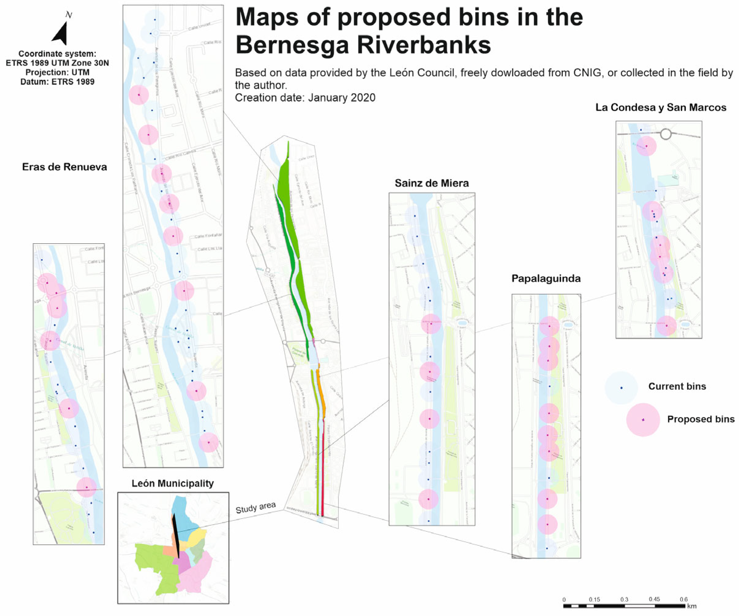
    Final map with new rubbish bins locations: the vote was taken in person during this session among the 9 best cartographic maps selected in session 6 (Figure 2).
Finally, a discussion on possible topics to be analyzed in the future courses with all the students together is planned. The number and type of interventions by the students can be considered a sign of their intrinsic motivation.
The discussions held by the students around protocols and analysis methods to draw the final conclusions from the results helped them to prioritize the information relevant for the report and understand what information should instead be left out. To add the last resulting map to the report presented to the City Council, a vote is held in session 7. Finally, based on the agreements reached in session 7 and extracting the text from the set of works presented by the students, the professors generated a single document and presented this to the City Council.
Phase 6. Reflection
SL projects include a phase to reflect about the issue raised and the proposal way to solve it. Students are used to learning new techniques, but it is difficult for them to extract results and apply them to improve the operational mode. Therefore, the objective of this phase is to improve their analytical thinking:
  • Reflective activity about (i) problems encountered, (ii) potential improved methods to apply in the future and (iii) waste issues in the city.
Although the project description considers it a separate phase, in practices, this activity is incorporated into session 7 of phase 5.

2.1.4. Post-Maintenance

This block still remains active. From time to time, the professor team keeps in touch with the local administration to share new SL applications. We have added other collaborations with new organizations that have ended on new SL projects, such as describing environmental places in an urban route for wheelchair users.

2.2. Student Observations and Outcomes

After the overall analysis, the students collected a total of 293 existing waste points located along the riverbanks; these include:
  • 3 dog waste bins;
  • 193 rubbish bins;
  • 12 glass waste containers;
  • 1 clothing and footwear waste container;
  • 1 battery waste container;
  • 16 paper and cardboard waste containers;
  • 40 mixed (organic and general) waste containers;
  • 21 plastic waste containers;
  • 6 building material waste containers.
All these waste collection points were recorded and characterized in a vector layer of points. Afterwards, students analyzed the distance among rubbish bins and indicated the locations where new bins should be placed. Results were displayed in a final map, with both the existing and proposed bin locations. The following problems that arose, when data were consolidated, and could have been avoided:
  • The use of different terminology to characterize the waste collection points. Some students did not follow the training script and improvised the name of each element, which caused many problems when joining the data from the different river sections. This heterogeneity in the description of the points forced the students to homogenize the data in the classroom for subsequent analyses.
  • The repetition of data collection at the limits of the sections of the study area, as some pairs of students did not respect the limits of their assigned section. This led to point duplications characterized in different manners.
  • Errors in the coordinates of the rubbish bins/containers due to the GNSS receiver and the presence of garden areas with an abundance of foliage that hindered data acquisition by increasing the GNSS error margin. In both cases, points were moved manually based on the orthoimage. Those groups who worked more meticulously completed this modification during the data acquisition phase, while those pairs who did not give the due importance to this process had to fix the data during session 3 in the classroom.
  • The presence of different types of waste containers close together. This situation led some pairs to add one point per container, while others assigned one single point with a long description, so that data needed to be homogenized later in the classroom.
In the last session of the service performance, students assessed all these issues and together designed a protocol.

2.3. Evaluation

The following two phases are the last ones in a SL project structure and aim to evaluate the students’ knowledge acquirement (Table 2) and the SL experience as a whole.
For the present study, only knowledge of GIS tools was graded quantitatively. Assessment of each student’s learning was based on three marks: one given by the professors, one by their peers, and the last one assigned by the technician of the Environmental Area of the City Council of León.
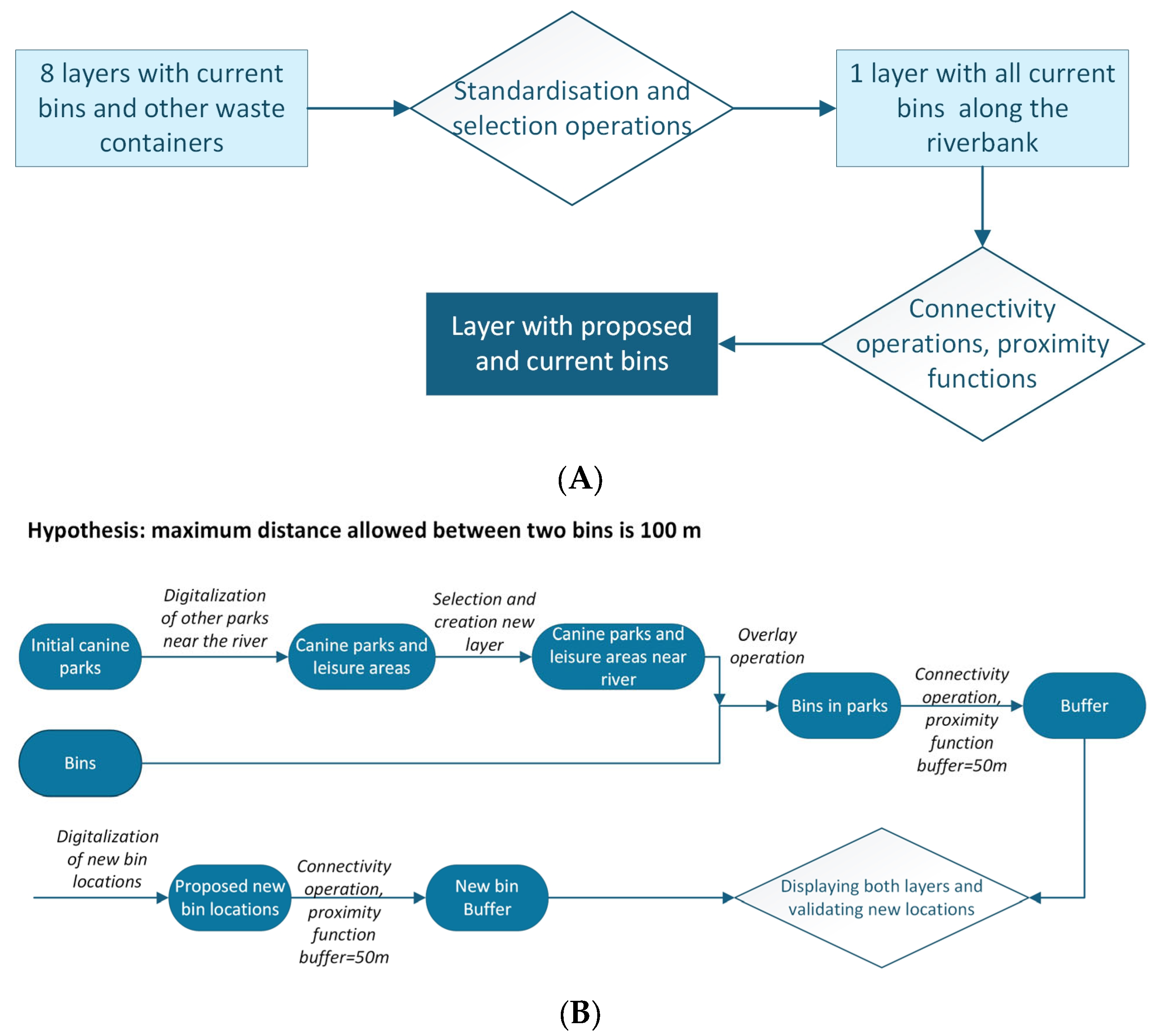
For the first mark, professors evaluated the final report written in pairs, following their schema and answering their own suggested questions (see rubric in Table A2; please note that some sections refer to other exercises performed using the Council’s database and are not related to the rubbish bin distribution along the river). The weight of this part is 80% of the final grade. Two examples of their schema may be found in Figure 3. The first image (A) corresponds to a low mark flowchart. There, the students incorporated the general operations, but they did not include the detailed ones used for selection of final results nor external data that were elaborated in other practices and should have been used to estimate the location of the new bins. Contrary, the flow chart of the second image (B) had a high mark. In this case, all data sources as well as intermediate GIS operations were included. It clearly shows all the process followed by the students to propose the location of new bins.
The second mark, weighted at 15%, was assigned by peer students following the rubric developed by the professors to evaluate their classmates’ maps (see Table A1). 53 students from the 67 participated in this assignment.
The third mark, weighted at 5% of the final grade, was the same for all those 53 students who attended to and participated in session 7, in which the final report for the City Council was defined. The technician of the Environmental Area of the City Council of León assigned this mark in a post-meeting session during a conversation with the professors.
Finally, we evaluated the SL experience. Once the training and evaluation were completed, an anonymous online survey prepared by the professors using Google Forms was offered to the students to ascertain the suitability of the project (Table 3). Additionally, the technician of the Environmental Area of the City Council of León also completed a short survey during the post-meeting session following the submission of the final document to qualitatively assess the SL project (Table 4). She was also asked about her interest in collaborating with us again in the future. A positive response was considered as a favorable evaluation of the SL experience. Students also offered their feedback during discussions in the service performance sessions, and Professors, based on their own experience, inquired about students’ feelings regarding this SL experience. The last goal of the project, the growing awareness of the existing waste problems in cities, could be tracked through various discussions with the students during the practical sessions, with emphasis during session 7.

3. Results

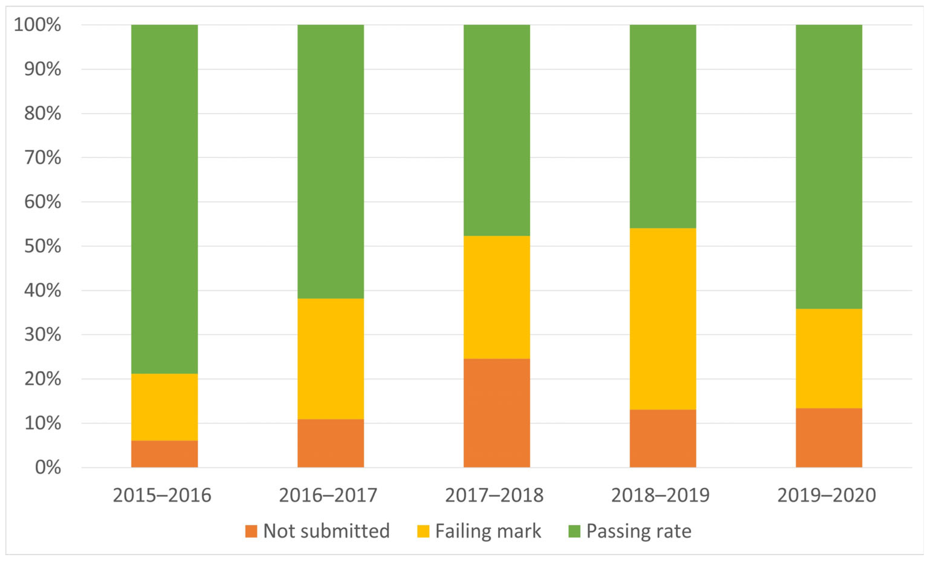
Students’ knowledge of GIS tools is assessed analyzing their final marks. From an academic point of view, the percentage of failures significantly decreased compared with those of the two previous academic year (2017–2018 and 2018–2019, Table 5). Also relevant, marks trend upward, reaching 15% of students with a B mark, from the 9 and 7% of previous years. However, no students obtained an A mark and the marks in this block of the course are still low compared with the final marks in the complete course of Cartography, Remote Sensing, and GIS (Figure 4). The number of not submitted students decreased both in the GIS block and in the course as a whole, although still represents a high rate for a third-year course.
The reports the students generated in pairs helped them to consolidate their GNSS and GIS skills acquisition level and their good performance following self-learning methods.
Finally, from the professor perspective, they observed a greater fluency in the use of vocabulary and an improvement in GIS management skills in students and, especially, an improvement in those skills related to the approach and subsequent resolution of environmental problems to be solved with GIS.
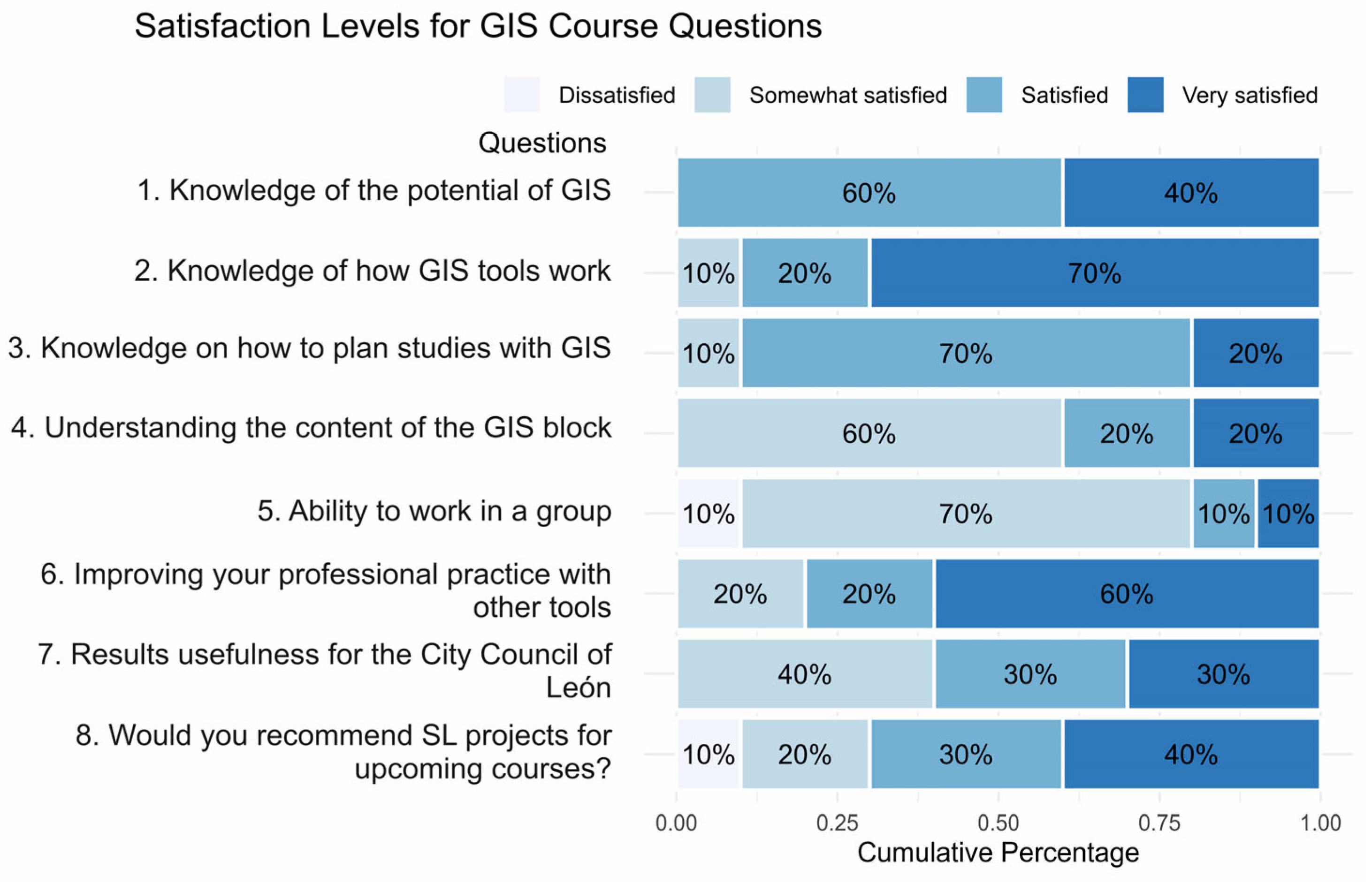
Once the training and the evaluation were completed, an anonymous survey was offered to the students to ascertain the suitability of the project. Out of 67 students, only 10 responded, but their responses were generally positive (Figure 5).
The following results, extracted from the student survey, show an overall highly positive assessment of the project:
  • Although out of the 67 students only 10 completed the survey, most of them show a high satisfaction with the work done. On a scale of 1 to 4 (from least to most satisfied), all of them consider that their knowledge about the potential of GIS has increased, with a value of 3–4.
  • Of note, 9 out of 10 students consider that their knowledge on how to design studies with GIS has increased. This is an instrumental subject, and it is vital that they know not only how to operate the software but also how to organize and analyze the data. In previous years, this knowledge was achieved, too, but students required more time.
  • Curiously, while expressing satisfaction with the acquired knowledge, 60% of the surveyed students feel that the project did not contribute significantly to their comprehension of the GIS component of the course.
  • In terms of teamwork learning, they feel that this practice has given them little benefit.
  • Of all the respondents, 80% value positively the use of other tools that used throughout the project, such as Google Drive or the GNSS application for mobile data collection.
  • Of those surveyed, 60% of students consider that the result can be of some use to the City Council of León.
  • 70% of the respondents would advise keeping this type of project in the course for following years.
  • In the last open-ended question, 6 out of the total 10 surveys stressed that the biggest problem encountered with this learning approach for the students is the amount of work and that the deadline for the final report coincided with other deadlines or exams from other courses. However, note that the initial deadline for the final report was December 21, but due to the amount of work the students had to do, this was postponed to January 8. Still, students consider that these were not the most appropriate dates.
These results alone, albeit quite positive, cannot be used on their own to assess whether or not the goals of the project were achieved as only 15% of students submitted the survey.
As it was above mentioned, a meeting was held with the environmental technician of the City Council of León, where she showed her satisfaction with the results assigning the maximum mark to the final report. Her positive answers to all questions of the Survey (Table 4) allowed to consider this project as a satisfactory service to the community, one of the main keys of the SL methodology. At the same time, her stated intention to use the students’ results in a future new proposal for the location of rubbish bins was considered a sign of having succeeded in the increase the visibility of students’ professionality.
To complement these results, we initiated a discussion during session 7 of the service performance, focusing on students’ proposals for the upcoming academic courses. A total of 53 students, divided into small groups of 3–4 participants, generated 14 new ideas, with 5 of them related to waste problem topics. However, these last ideas, which partly involved replicating the study in new neighborhoods and partly were deemed unfeasible within the short duration of the course, were declined. After sharing and refining the rest of ideas, the students’ final proposals were as follows:
  • Identification of hazardous areas within the city’s bikeways and assessment of a potential extension.
  • Localization of urban drinking-water sources and new ones proposal.
  • Fossil route in the city of León.
  • Localization of bus stops in the city and new ones proposal.
  • Analysis of green areas in relation to the population density in different districts in the city.
The overall discussion showed the interest of most of the students for this type of study.

4. Discussion

Our results from the SL project show that the main goals of the present study enhancing GIS knowledge, increase the visibility of students’ professionality and prompting reflection on urban waste issues were achieved. Throughout the project analyzed herein, the students improved their knowledge of contents specific to GIS, while developing cross-cutting competencies. Students were made aware of the importance of collaborative work when problems arose as a result of lack of communication among them. Talking with your team and agreeing on how you are going to work in the field is key. Based on this experience, students proposed a protocol for future studies about rubbish bin location in the city. This protocol clearly reflects the acquisition of technical GIS knowledge and skills by students, who suggested solutions for all the problems they faced during the project: name and code for the collected elements by GNSS, use of one single point for several nearby containers to work with small–medium scale maps, file format, etc.
The professors of this subject have observed throughout their professional careers that the flowcharts illustrating the steps followed with GIS are an effective learning tool. Creating these diagrams helps students to synthesize the operations performed, reinforcing their understanding of analysis procedures by visualizing the tool’s input data and the type of data it generates. In the SL study analyzed, this tool has also proven useful in capturing the students’ decision-making process when selecting locations for new bins. Differences in Figure 3A,B have allowed to differentiate the knowledge level acquisition.
Since SL was planned as a compulsory activity, a control group was not included in the study [54]. The tendency for the most motivated students to volunteer for service-learning activities can introduce bias when assessing the impact of the service-learning approach on knowledge acquisition based on a control group. To mitigate this issue, some studies propose techniques to minimize bias [61,62]. However, implementing these methods at the university level is challenging, as professors have limited weekly contact hours per semester, and the activity must start within a few weeks of meeting the students. Moreover, given that service-learning has been widely proven effective by large amount of bibliography, excluding a group of students from its benefits is difficult to justify both ethically and logically [63].
Of all the planned sessions, session 7, which was dedicated to the final report preparation, turned out to be a key element in evaluating the project’s success. This session provided significant insights into collaborative learning and analytical thinking, allowing participants to draw their own conclusions and define the analytical process followed throughout the project.
All this learning resulted in a decrease in the percentage of failures in the course Cartography, Remote Sensing and GIS compared with those of the last three years. This improvement is consistent with other studies [64,65], which suggest that participation in SL activities improves students’ performance in practical tasks like case studies or essays, rather than theoretical assessments such as multiple-choice tests. Since the exam in this course is predominantly practical, it can be used as an indicator of the impact of SL has had on student learning. The improved grades observed for this course (Table 5) suggests that the implementation of SL methodology may have contributed to a better understanding of the course contents among the students.
The low number of students passing this course in previous years should be analyzed within the educational framework of the Environmental Sciences degree at the University of León as a whole, since this tendency also appeared in all the other courses of the third year (E. Colmenero (Head of Quality of the Faculty), personal communication, May 2020). However, during the academic year studied in the present work (2019–20), the number of passing students in this course increased (Figure 2); this tendency was not mirrored in the rest of the third-year courses during this academic year. In addition, professors are the same than years before and the general teaching method has not changed (except for the SL case). The overall of this scenario suggests that the implementation of an SL methodology through the project analyzed in the present study may have improved the motivation of the students, favoring the acquisition of the minimum contents demanded by the course, in line with the findings by [13] or [24]. However, the decrease of failures of this course may also be due to the high number of re-enrolled students who understood the subject after attending the course for the second time. It is remarkable that, despite these good results, students still feel that the SL project did not help them to pass the GIS block. A possible explanation is that many students still rely on rote learning techniques to pass the subject and find it challenging to bridge the gap between theoretical knowledge and practical application.
The low number of queries answered makes difficult to quantify the student’s satisfaction with the SL approach. The reason for this low number compared to similar studies may be found on the compulsory aspect of the activity, when most of the SL cases are volunteering [53]. Nevertheless, the active conversations with students during the GIS sessions showed their potential as a tool to evaluate whether the project’s main goals were being achieved. Statements such us “The other day I was walking around my neighborhood and I realized that rubbish bins are located in really bad places, with long distances among them” or “Studies like this should be done in other neighborhoods besides the river path, because there are difficulties to find rubbish bins in some of them” show the students’ self-reflection on urban waste issues. Additionally, although it is evident that the number of students who participated in the satisfaction survey is low, this fact does not diminish the importance of the experiment carried out, as the project effect is demonstrated by the good reception by the public administration, which has benefited from this transfer teaching initiative with a clear social implication at the level of the benefit of the local administration (City Council), directed towards the citizens of León.
In general, the three groups involved in this project (students, professors, and the City Council) evaluated the experience as positive and beneficial. The students stated that this experience has helped them to better understand GIS tools and the handling of a GNSS, which is consistent with the theories that suggest that active learning and the active participation of students in the teaching process improve the results [25]. Professors observed the development of technical vocabulary and critical and reflective thinking in the students, thanks to the reflection–action cycles followed during the project [66,67]; this goes beyond just “learning one more set of techniques” [68]. The environmental technician expressed her satisfaction with the results, acknowledged the usefulness of the data collected, and stated her willingness to continue collaborating in the future, contributing with new ideas for future projects. In fact, in the following academic year (2020–2021) we continued this collaboration to study new different neighborhoods.
Despite all these benefits, the implementation of SL projects involves some challenges. One of the main ones encountered in this practice was the search for an external collaborator, since it was not known which institutions might be willing to participate. Finally, it was decided to collaborate with the Environmental Area of the City Council because Environmental Sciences students complete their internships there. Therefore, our recommendation to other professionals who want to implement this type of project but do not know who to contact is to search for public organizations or associations where their students’ complete internships. In general, these organizations are receptive to this type of activities.
The second difficulty encountered was the definition of the activity itself. Locating rubbish bins does not fall within the scientific field of the professors who teach this course in the University of León, but after the technical advice from the City Council, increasing student motivation was prioritized over scientific experience. This lack of knowledge in the field of practice was compensated by the extensive experience of the professors with GIS tools. A second recommendation derives from this scenario: flexibility of the teaching staff in terms of the subject matter to be developed within the project.
Another challenge is the lack of student participation in evaluating the service-learning activity. Low participation is a recurring issue across all quality assessment questionnaires distributed by the University. To address this, the University is experimenting with various strategies, such as distributing paper questionnaires during theoretical sessions and sending surveys via email. However, response rates remain consistently low.
Finally, once the project was planned, some doubts among professors arose regarding the compulsory nature of these activities because some colleagues had performed some SL projects as optional activities. This is a common debate in universities [59,69]. From our perspective, the results achieved by making these activities compulsory were optimal, and the number of students who benefited was greater than it would have been had we left participation in the SL project as an optional activity. On many occasions, SL involves working with vulnerable groups, making it more appealing for students to volunteer; however, this was not the case in our project, and therefore, incorporating SL as a mandatory learning activity brought more benefits than harm. Another possibility is to make it optional but necessary to achieve the maximum score. This option has been tested in academic years subsequent to the one described in the present study. The number of students who benefited with this method was much lower, although, once again, those who did participate presented highly satisfactory reports, most of them with scores above 7 out of 10. In view of the present results and in line with previous studies [1,37,52] we consider necessary to continue with the promotion and consolidation of SL in the area of environmental sciences and geosciences, given its highly positive impact. We also believe in the need of making it compulsory to improve the results of a greater number of students and to compel the university to participate in the social responsibility that the institution has within the society [21].

5. Conclusions

The conclusions that can be drawn from this innovating teaching project are summarized as follows:
  • The use of this type of project facilitates the teaching of techniques within the objectives of the course and also of the collection and implementation processes that this type of techniques requires, that is a much deeper and closer to the professional experience knowledge.
  • At an academic level, the project goals were achieved, and the results have improved compared with those of previous years, although these are still far from satisfactory for a third-year undergraduate course. In any case, part of this academic issue is structural, since this is also observed as a general trend when considering the average number of credits from all courses obtained by all undergraduate students.
  • The City Council technician was satisfied with the implementation of this SL project. Pleased with the results, she planned to incorporate them into future studies and requested ongoing collaboration for upcoming initiatives.
  • The fact of working with problems close to the students, such as urban waste, makes it easier to reflect on these problems throughout the project.
Projects like this not only develop technical skills but also provide a deeper understanding of data collection and implementation processes related to environmental issues, offering a meaningful connection to real-world environmental challenges and professional experiences. Furthermore, the participation and evaluation of the results by the city council’s technical staff enhances and validates the meaning and importance of this SL project, which is an initial example for its improvement and reinforcement in future applications.

Author Contributions

Conceptualization, M.F.-J. and E.G.-M.; methodology, M.F.-J. and E.G.-M.; data analysis, J.A.C. and I.P.; writing—original draft preparation, M.F.-J. and I.P.; writing—review and editing, All authors. All authors have read and agreed to the published version of the manuscript.

Funding

This research was funded by the Support Plan for Innovative Teaching (PAID) of the University de León (course 2019–2020, Ref. PAID-2019). I. Pereira’s participation was supported by an FPU contract (Ref. FPU21/04495) from the Spanish Ministry of Universities.

Data Availability Statement

The data presented in this study are available on request from the corresponding author due to data protection of students’ identities.

Acknowledgments

This project would not have been possible without the collaboration of the Environmental Department of the City Council of León, which, through its technician Sara Rodríguez, provided the necessary data for the initial study as well as some technical recommendations. We also want to thank all the students of the Cartography, Remote Sensing, and GIS course in 2019–2020 who participated in this activity and our colleague and Head of Quality of our Faculty, Elena Colmenero Hidalgo, for her assistance in the elaboration of this paper.

Conflicts of Interest

The authors declare no conflicts of interest.

Appendix A

Table A1. Rubric to evaluate the maps (for students and professors).
Maximum Value
Cartographic elements5
Legend: good design, without orthographic errors and showing only elements represented in the map1
North0.5
Scale0.5
Coordinate grid0.5
Text with referenced cartographic system. Avoiding mixture of languages0.5
Title: clear, brief and concise1
Inclusion of reference map to facilitate localizing the study area1
Use of different data frames1
Evaluate if different data frames have been used as suggested in the training material1
Symbology3
Easy reading of the map, so you should consider the adequacy of symbol type, size and color. To evaluate these issues, consider the map scale: if you need a zoom in higher than the map scale to read the symbol, the symbology is not right.3
Cartographic composition1
Distribution of the cartographic elements in the final sheet, readability and pleasant design1
Total10
Table A2. Rubric to evaluate the final report by pairs.
0–45–78–10
IntroductionText without context, so it is difficult for the reader to know what is the writing aboutPoor context about the problem that they are going to solve in the script.Good description of the problem, with the background in León city.
Data collectionList of the problems found during the practice without description of their sourceBrief explanation of some problems found during the practice giving some details about their possible origin; a list of different ideas to follow as a protocolDescription of the problems found during the practice with an analysis of their origin; detailed protocol proposal.
Flow chartLack of some important operations; illogical flow; messy presentationLack of some analytical operations; logical flow but messy presentationEvery analytical operation included; logical flow, easy to follow; clear presentation.
Analysis of the resultsInformation not always relevant; some questions not addressed; not well understood most of the GIS operationsRelevant information; not well understood some of the GIS operationsRelevant information, deep analysis of GIS operations
MapSee Rubric of maps (Table A1)
WritingPaper is difficult to read; not well organized; text does not follow a logical order; grammar mistakes; problems to understand the concepts.Some paragraphs not fully developed; sometimes, reader gets lost, text is not clear; some concepts are used out of context; there are few grammar mistakes.Well-organized text; easy to read, following a logical flow; excellent use of concepts; without grammar mistakes.

References

  1. National Academies of Sciences, Engineering, and Medicine. Service-Learning in Undergraduate Geosciences: Proceeding of the Workshop on Service-Learning in Undergraduate Geosciences; The National Academies Press: Washington, DC, USA, 2017. [Google Scholar] [CrossRef]
  2. Dicke, L.; Dowden, S.; Torres, J. Successful service learning: A matter of ideology. J. Public Aff. Educ. 2004, 10, 199–208. [Google Scholar] [CrossRef]
  3. Furco, A.; Norvell, K. What is service learning? In Embedding Service Learning in European Higher Education; Routledge: London, UK, 2019. [Google Scholar] [CrossRef]
  4. Puig, J.M.; Gijón, M.; Martín-García, X.; Rubio, L. Aprendizaje-servicio y Educación para la ciudadanía. Rev. Educ. 2011, 45, 45–67. [Google Scholar]
  5. Bringle, R.; Hatcher, J. Institutionalization of service learning in higher education. J. High Educ. 2000, 71, 273–290. [Google Scholar] [CrossRef]
  6. Sánchez, M.E.; Hernández, Y.; Hernández, S. Innovación docente en recursos humanos a través del aprendizaje-servicio. Una experiencia piloto. RIDAS Rev. Iberoam. Aprendiz. Serv. 2019, 7, 1–16. [Google Scholar] [CrossRef]
  7. Sotelino-Losada, A.; Santos, M.A.; Priegue, D. Service-learning and employability. A view from the major areas of scientific knowledge. Procedia Soc. Behav. Sci. 2014, 139, 93–101. [Google Scholar] [CrossRef]
  8. Aramburuzabala, P.; Cerrillo, R. Service-Learning as an approach to educating for sustainable development. Sustainability 2023, 15, 11231. [Google Scholar] [CrossRef]
  9. Chaumba, J. Improving student’s mineral and rock identification skills through service-learning. J. Community Engagem. High. Educ. 2022, 14, 58–69. [Google Scholar] [CrossRef]
  10. UNESCO. Skills for Holistic Human Development (THA/DOC/EPR/14/040-500). UNESCO Bangkok 2014. Volume 2. Available online: https://unesdoc.unesco.org/ark:/48223/pf0000245064/PDF/245064eng.pdf.multi (accessed on 17 December 2024).
  11. Folgueiras, P.; Aramburuzabala, P.; Opazo, H.; Mugarra, A.; Ruiz, A. Service-learning: A survey of experiences in Spain. Educ. Citiz. Soc. Justice 2018, 15, 162–180. [Google Scholar] [CrossRef]
  12. Sotelino-Losada, A.; Arbués-Radigales, E.; García-Docampo, L.; González-Geraldo, J.L. Service-Learning in Europe. Dimensions and understanding from academic publication. Front. Educ. 2021, 6, 604825. [Google Scholar] [CrossRef]
  13. Hasan, A.; Ali, I.; Khan, M.A.; Hamid, K. A study of university students’ motivation and its relationship with their academic performance. Int. J. Bus. Manag. 2010, 5, 80–86. [Google Scholar] [CrossRef]
  14. Wutzdorff, A.; Giles, D. Chapter VIII: Service-learning in higher education. Teach. Coll. Rec. 1997, 98, 105–117. [Google Scholar] [CrossRef]
  15. Salam, M.; Iskandar, D.N.A.; Ibrahim, D.H.A.; Farooq, M.S. Technology integration in service-learning pedagogy: A holistic framework. Telemat. Inform. 2019, 38, 257–273. [Google Scholar] [CrossRef]
  16. Sánchez-Carracedo, F.; López, D. A service-learning based computers reuse program. Sustainability 2021, 13, 7785. [Google Scholar] [CrossRef]
  17. Queiruga-Dios, M.; Santos Sánchez, M.J.; Queiruga-Dios, M.Á.; Acosta Castellanos, P.M.; Queiruga-Dios, A. Assessment methods for service-learning projects in engineering in higher education: A systematic review. Front. Psychol. 2021, 12, 629231. [Google Scholar] [CrossRef] [PubMed]
  18. Elumalai, K.V.; Sankar, J.P.; Kalaichelvi, R.; John, J.A.; Menon, N.; Alqahtani, M.S.M.; Abumelha, M.A. Factors affecting the quality of e-learning during the COVID-19 pandemic from the perspective of higher education students. J. Inf. Technol. Educ. Res. 2021, 19, 731–753. [Google Scholar] [CrossRef]
  19. Dapena, A.; Castro, P.M.; Ares-Pernas, A. Moving to e-service learning in higher education. Appl. Sci. 2022, 12, 5462. [Google Scholar] [CrossRef]
  20. Keen, C.; Baldwin, E. Students promoting economic development and environmental sustainability: An analysis of the impact of involvement in a community-based research and service-learning program. Int. J. Sustain. High. Educ. 2004, 5, 384–394. [Google Scholar] [CrossRef]
  21. Martínez, M. (Ed.) Aprendizaje Servicio y Responsabilidad Social de las Universidades; Ediciones Octaedro-ICE: Barcelona, Spain, 2008. [Google Scholar]
  22. Tapia, M.N. Calidad académica y responsabilidad social: El aprendizaje servicio como puente entre dos culturas universitarias. In Aprendizaje Servicio y Responsabilidad Social de las Universidades; Martínez, M., Ed.; Ediciones Octaedro-ICE: Barcelona, Spain, 2008; pp. 27–56. [Google Scholar]
  23. Hernández-Barco, M.; Sánchez-Martín, J.; Blanco-Salas, J.; Ruiz-Téllez, T. Teaching down to earth—Service-learning methodology for science education and sustainability at the university level: A practical approach. Sustainability 2020, 12, 542. [Google Scholar] [CrossRef]
  24. Alonso Tapia, J.; Fernández, J. Development and initial validation of the Classroom Motivational Climate Questionnaire (CMCQ). Psicothema 2008, 20, 883–889. [Google Scholar]
  25. Alonso Tapia, J.; Pardo, A. Assessment of learning environment quality from the point of view of secondary and high-school learners. Learn. Instr. 2006, 16, 295–309. [Google Scholar] [CrossRef]
  26. Singh, K. Study of achievement motivation in relation to academic achievement of students. Int. J. Educ. Plan. Adm. 2011, 1, 161–171. [Google Scholar]
  27. Cebrián, G.; Fernández, M.; Fuertes, M.T.; Moraleda, A.; Segalàs, J. The influence of service-learning on the development of sustainability competencies amongst university students. Bordón 2019, 71, 151–167. [Google Scholar] [CrossRef]
  28. Sánchez-Barroso, G.; González-Domínguez, J.; García-Sanz-Calcedo, J.; Zamora-Polo, F. Analysis of learning motivation in Industrial Engineering teaching in University of Extremadura (Spain). Sustainability 2020, 12, 4987. [Google Scholar] [CrossRef]
  29. UNESCO. World Conference on Higher Education. Final Report. UNESCO 2009. Available online: https://unesdoc.unesco.org/ark:/48223/pf0000189242 (accessed on 17 December 2024).
  30. García-Laso, A.; Marín, D.A.; Costafreda, J.L.; Nuñez, E.; Rodríguez, J.A. Aprendizaje-Servicio (ApS) como metodología para alcanzar los Objetivos de Desarrollo Sostenible (ODS). In Proceedings of the V Congreso Internacional Sobre Aprendizaje, Innovación y Cooperación, Zaragoza, Spain, 9–11 October 2019. [Google Scholar]
  31. United Nations. Resolution Adopted by the General Assembly on 25 September 2015. A/RES/70/1. Available online: https://www.un.org/en/development/desa/population/migration/generalassembly/docs/globalcompact/A_RES_70_1_E.pdf (accessed on 17 December 2024).
  32. Aramburuzabala, P.; Cerrillo, R.; Tello, I. Aprendizaje-servicio: Una propuesta metodológica para la introducción de la sostenibilidad curricular en la universidad. Profr. Rev. Currícul. Form. Profr. 2015, 19, 78–95. [Google Scholar]
  33. Conferencia de Rectores de las Universidades Españolas (CRUE). Directrices Para la Introducción de la Sostenibilidad en el Curriculum. CRUE 2012. Available online: https://www.crue.org/Documentos%20compartidos/Declaraciones/Directrices_Sosteniblidad_Crue2012.pdf (accessed on 17 December 2024).
  34. Schneller, S. Environmental service learning: Outcomes of innovative pedagogy in Baja California Sur, Mexico. Environ. Educ. Res. 2008, 14, 291–307. [Google Scholar] [CrossRef]
  35. Calvo Galván, M.L.; Centeno Martín, M.L.; Colmenero Hidalgo, E.; García García, P.; Fernández Villadangos, A.; López Campano, L.; Martínez, M.M.; Vieira, M.C.M.; Delgado, L.M.M.; Gutiérrez, J.L.M.; et al. Incorporación de la metodología “service-learning” en la Facultad de ciencias biológicas y ambientales de la Universidad de León = Introduction of service-learning teaching method at the Faculty of biology and environmental science (University of León). Teach. Learn. Innov. J. 2017, 1, 14–18. [Google Scholar] [CrossRef]
  36. Coleman, K.; Murdoch, J.; Rayback, S.; Seidl, A.; Wallin, K. Students’ understanding of sustainability and climate change across linked Service-Learning courses. J. Geosci. Educ. 2017, 65, 158–167. [Google Scholar] [CrossRef]
  37. Mileusnić, M. Service learning in geoscience education. Eur. Geol. J. 2020, 50, 6–9. [Google Scholar] [CrossRef]
  38. Dale, A.T.; Lennox, E.R.; Best, R.E.; McKahn, D.A.; Hess, J.L.; Jensen, M.K. Connections without command: ESW’s service-learning approach. Int. J. Serv. Learn. Eng. 2014, 48–61. [Google Scholar] [CrossRef]
  39. Al-Khafaji, K.; Morse, M. Learning sustainable design through service. Int. J. Serv. Learn. Eng. 2006, 1, 50. [Google Scholar] [CrossRef]
  40. Campbell-Montalvo, R.; Campbell, T.; Park, B.Y.; Arnold, C.; Volin, J.C.; Chrysochoou, M.; Diplock, P.C. E-corps’ implementation of environmental sustainability-focused service-learning: Conditions supporting the establishment of an epistemic community. J. STEM Outreach 2021, 4, 1–12. [Google Scholar] [CrossRef]
  41. Burns, H.L.; Miller, W. The learning gardens laboratory: Teaching sustainability and developing sustainable food systems through unique partnerships. J. Agric. Food Syst. Community Dev. 2012, 2, 69–78. [Google Scholar] [CrossRef]
  42. Wozniak, J.R.; Bellah, J.C.; Riley, J.M. Building a community garden: A collaborative cross-disciplinary academic community engagement project. J. Bus. Strat. 1970, 33, 95–115. [Google Scholar] [CrossRef]
  43. Newman, G.D.; Shi, T.; Yao, Z.; Li, D.; Sansom, G.T.; Kirsch, K.R.; Casillas, G.A.; Horney, J.A. Citizen science-informed community master planning: Land use and built environment changes to increase flood resilience and decrease contaminant exposure. Int. J. Environ. Res. Public Health 2020, 17, 486. [Google Scholar] [CrossRef] [PubMed]
  44. Henley, R.; Unger, D.; Kulhavy, D.L.; Hung, I. Incorporating applied undergraduate research in senior to graduate level remote sensing courses. Int. J. High. Educ. 2016, 5, 232–248. [Google Scholar] [CrossRef]
  45. Meyer, M.A.; Hendricks, M.D.; Newman, G.D.; Horney, J.A.; Berke, P.; Masterson, J.; Sansom, G.T.; Cousins, T.; Van Zandt, S.; Cooper, J. Participatory action research in planning for climate adaptation: Applications in flood-prone communities. Sustainability 2018, 10, 3527. [Google Scholar] [CrossRef]
  46. Masterson, J.; Meyer, M.A.; Ghariabeh, N.; Hendricks, M.D.; Lee, R.J.; Musharrat, S.; Newman, G.D.; Sansom, G.T.; Van Zandt, S. Interdisciplinary citizen science and design projects for hazard and disaster education. Int. J. Mass Emerg. Disasters 2019, 37, 6–24. [Google Scholar] [CrossRef]
  47. Kulhavy, D.L.; Unger, D.; Viegut, R.A.; Hung, I.; Zhang, Y. Integration of CITYgreen landscape ecological analysis into a capstone environmental science course. Int. J. High. Educ. 2020, 9, 259. [Google Scholar] [CrossRef]
  48. Trott, C.D.; Weinberg, A.E.; McMeeking, L.B. Prefiguring sustainability through participatory action research experiences for undergraduates: Reflections and recommendations for student development. Sustainability 2018, 10, 3332. [Google Scholar] [CrossRef]
  49. Pinfold, N.; Mokhele, M. Bridging the gap between technical and social competencies of urban and regional planning through mobile technology: The case of Cape Peninsula University of Technology. J. Transdiscipl. Res. S. Afr. 2020, 16, 7. [Google Scholar] [CrossRef]
  50. Norton, E.; Li, Y.; Mason, L.R.; Washington-Allen, R.A. Assessing the impact of a geospatial data collection app on student engagement in environmental education. Educ. Sci. 2019, 9, 118. [Google Scholar] [CrossRef]
  51. de Lázaro Torres, M.L.; Borderías Uribeondo, P.; Morales Yago, F.J. Citizen and educational initiatives to support Sustainable Development Goal 6: Clean water and sanitation for all. Sustainability 2020, 12, 2073. [Google Scholar] [CrossRef]
  52. Silka, L. Service Learning in the Geosciences: Opportunities for innovation. In Proceedings of the Workshop on Service-Learning in Undergraduate Geosciences; The National Academies Press: Washington, DC, USA, 2017; pp. 20–21. [Google Scholar]
  53. Thompson, K.; Bickmore, B.R.; Graham, C.R.; Yanchar, S.C. Earth Science mini-lessons: A service-learning strategy for improving attitudes toward science of preservice elementary teachers. J. Geosci. Educ. 2007, 55, 228–234. [Google Scholar] [CrossRef]
  54. Nunn, J.A.; Braud, J. A Service-Learning project on volcanoes to promote critical thinking and the Earth Science literacy initiative. J. Geosci. Educ. 2013, 6, 28–36. [Google Scholar] [CrossRef]
  55. Cea, P.A.; Muñoz, M.; Bull, M.; Oyarzo, C.; Sanhueza, F. Aprendizaje servicio aplicado a la gestión de desastres en establecimientos educacionales municipales. RIDAS Rev. Iberoam. Aprendiz. Serv. 2017, 3, 131–136. [Google Scholar] [CrossRef]
  56. Alsina, M.; Gaona, R.; Ventura, P.; Bel, G.; Fornell, D. Service-learning experience through outreach and engagement with science and technology museums. In Proceedings of the SEFI 50th Annual Conference of The European Society for Engineering Education, Barcelona, Spain, 19–22 September 2022; pp. 76–83. [Google Scholar]
  57. Zhu, X. GIS for Environmental Applications: A Practical Approach; Routledge: London, UK, 2016. [Google Scholar]
  58. Sacristán-Díaz, M.; Garrido-Vega, P.; Zamora, M.D.M.G.; Alfalla-Luque, R. ¿Por qué los alumnos no asisten a clase y no se presentan a los exámenes? Datos y reflexiones sobre absentismo y abandono universitario. WPOM-Work. Pap. Oper. Manag. 2012, 3, 101–112. [Google Scholar] [CrossRef]
  59. Chan, S.C.; Ngai, G.; Kwan, K. Mandatory service learning at university: Do less-inclined students learn from it? Act. Learn. High. Educ. 2019, 20, 189–202. [Google Scholar] [CrossRef]
  60. Eyler, J.; Giles, D.E., Jr. Where’s the Learning in Service-Learning? Jossey-Bass: San Francisco, CA, USA, 1999. [Google Scholar]
  61. Markus, G.B.; Howard, J.P.; King, D.C. Integrating community service and classroom instruction enhances learning: Results from an experiment. Educ. Eval. Policy Anal. 1993, 15, 410–419. [Google Scholar] [CrossRef]
  62. Petrovskaya, I. A shift towards self-transcendence: Can service learning make a difference? Horizon 2019, 27, 5–11. [Google Scholar] [CrossRef]
  63. Taber, K.S. Experimental research into teaching innovations: Responding to methodological and ethical challenges. Stud. Sci. Educ. 2019, 55, 69–119. [Google Scholar] [CrossRef]
  64. Billig, S.; Root, S.; Jesse, D. The impact of participation in service-learning on high school students’ civic engagement. In CIRCLE Working Paper 33; Center for Information and Research on Civic Learning and Engagement (CIRCLE): College Park, MD, USA, 2005. [Google Scholar]
  65. Mpofu, E. Service-learning effects on the academic learning of rehabilitation services students. Mich. J. Community Serv. Learn. 2007, 14, 46–52. [Google Scholar]
  66. Rodríguez-Gallego, M. El Aprendizaje-Servicio como estrategia metodológica en la Universidad. Rev. Complut. Educ. 2014, 25, 95–113. [Google Scholar] [CrossRef]
  67. García, D.; Lalueza, J.L. Procesos de aprendizaje e identidad en aprendizaje servicio universitario: Una revisión teórica. Educ. XX1 2019, 22, 45–68. [Google Scholar]
  68. Pribbenow, D.A. The impact of Service-Learning pedagogy on Faculty Teaching and Learning. Mich. J. Community Serv. Learn. 2005, 11, 25–38. [Google Scholar]
  69. Stukas, A.A.; Clary, G.E.; Snyder, M. Service Learning: Who benefits and why? Soc. Policy Rep. 1999, 8, 1–22. [Google Scholar] [CrossRef]
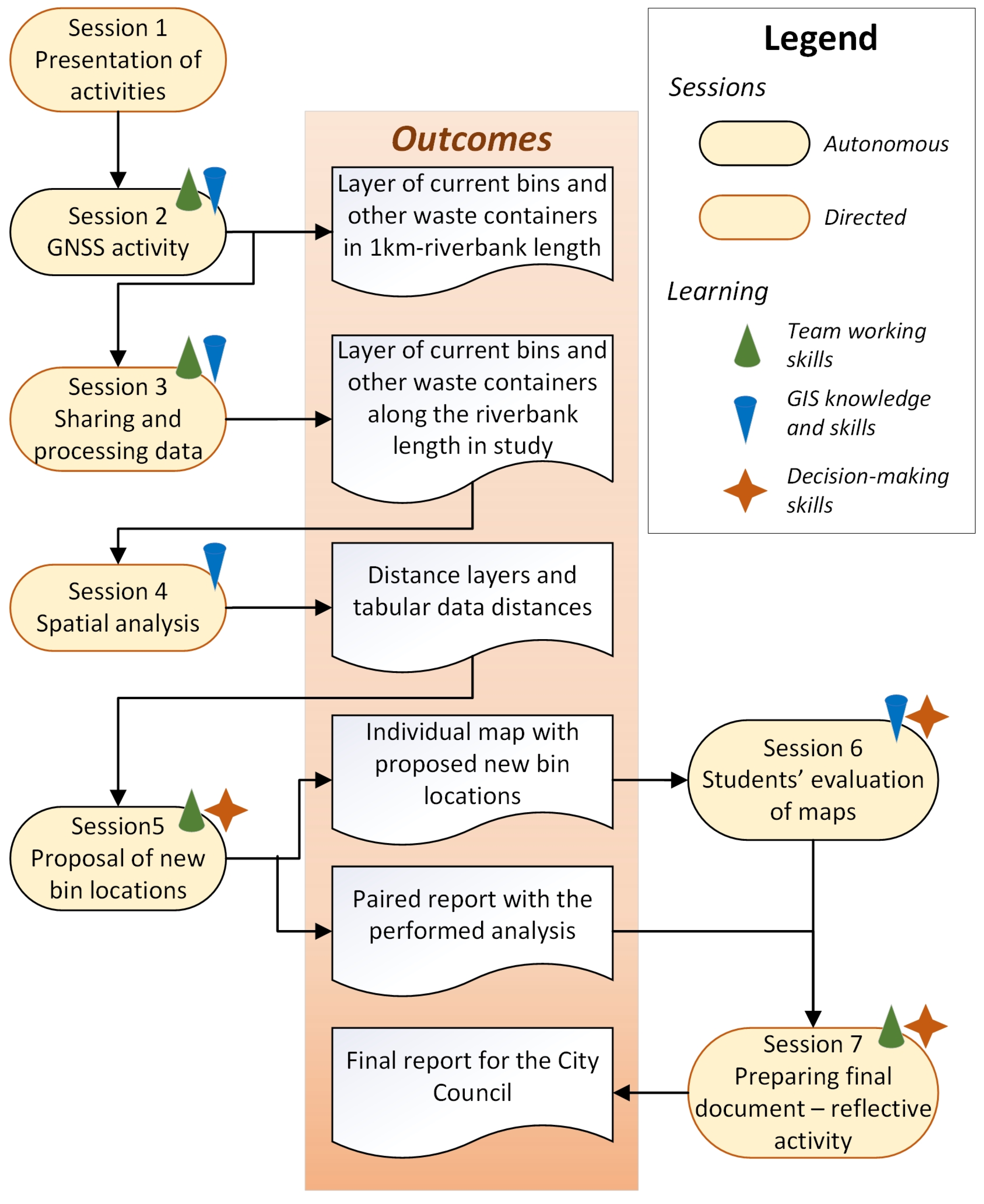
Figure 1. Flowchart with the service performance and reflection sessions.
Sustainability 17 02276 g001
Figure 2. Map chosen from students to incorporate in the final report submitted to the City Council. Different colors refer to different neighborhoods in the location maps (Leon municipality and study area).
Sustainability 17 02276 g002
Figure 3. (A) Schema developed by students evaluated (A) with a low mark and (B) with a high mark.
Sustainability 17 02276 g003
Figure 4. Temporal evolution of the % of students passing, failing and not submitting the complete Cartography, Remote Sensing, and GIS course.
Sustainability 17 02276 g004
Figure 5. Answers to the satisfaction survey completed by the students of the Cartography, Remote Sensing, and GIS course. The answers corresponding to the last two questions are not included as these are open-ended questions.
Sustainability 17 02276 g005
Table 1. Evolution of the percentage of re-enrolled students in Cartography, GIS, and remote sensing courses and number of courses with more than 5% of re-enrolled students.
Academic Course2014–20152015–20162016–20172017–20182018–20192019–2020
% of re-enrolled students in the study course4926212939
Number of courses with >5% re-enrolled students in the Environmental Sciences degree262927333532
Table 2. What is being evaluated to achieve the goals and specific objectives of the present study.
Main GoalsSpecific Objectives Aimed at StudentsWhat Is Being Evaluated
GIS knowledge/skillsUsing a mobile application to locate points in the field using the GNSSFinal report by pairs
Students’ evaluation of the maps.
Applying spatial operations using GIS to the data obtained by the students themselves
Determining satisfaction of the serviceDrawing conclusions from the results obtained and how to present them to deliver to City Council’s environment technicianConversation in a post meeting session with the technician of the Environmental Area of the City Council
Waste problemIncreasing awareness of the existing waste problems in citiesDiscussions with students on-going during the entire project, with emphasis on session 7
Table 3. Student survey (translated from Spanish). Questions 9 and 10 are open-ended; the rest offer four possible answers: dissatisfied, somewhat satisfied, satisfied, and very satisfied.
Student Survey Questionnaire
1. Has your knowledge of the potential of GIS increased?
2. Has your knowledge of how GIS tools work increased?
3. Has your knowledge on how to plan studies with GIS increased?
4. Did the rubbish bin training help you to understand the content of the GIS block of the Cartography, Remote Sensing, and GIS course?
5. How much has your ability to work in a group improved?
6. Do you think that other tools used in this project (Google Drive, GNSS) can help you in your professional practice?
7. Will the achieved results be useful to the City Council of León?
8. Would you recommend that this type of project be performed in the course in other academic years?
9. Was there anything you particularly liked?
10. Is there anything you would change from this project in the course?
Table 4. Survey for the technician of the Environmental Area of the City Council of León.
Technician Survey Questionnaire
1. Do you consider this type of projects to improve the academic training of the students?
2. From a potential employer point of view, do you consider that the content of this project aligns with real-life professional research?
3. Do you consider the results achieved to be able to help the Council to place new rubbish bins?
Table 5. Evolution of student final marks in the GIS block of the Cartography, Remote Sensing, and GIS course in the Environmental Sciences degree of the University of León. Grades in Spain are as follows: C mark is anywhere between 50% and 69%, B is between 70% and 89% and A is between 90% and 100%. A failing mark is that below 50%. Not submitted category corresponds to those students that did not take the examination, which is compulsory to achieve A-C marks (although they submitted the SL project assignment).
Category2017–2018 (%)2018–2019 (%)2019–2020 (%)
Not submitted251311
Failing mark354930
C mark313144
B mark9715
A mark000
Passing rate (a + b + c marks)403859
Disclaimer/Publisher’s Note: The statements, opinions and data contained in all publications are solely those of the individual author(s) and contributor(s) and not of MDPI and/or the editor(s). MDPI and/or the editor(s) disclaim responsibility for any injury to people or property resulting from any ideas, methods, instructions or products referred to in the content.