Abstract
The Haidian District was, historically, rich in water resources. However, with urban development, the groundwater levels have declined, and most rivers have lost their ecological baseflows. To restore the aquatic ecosystems, the district has implemented a cyclic water network and advanced water replenishment projects. Nonetheless, the existing replenishment strategies face challenges, such as an insufficient scientific basis, lack of data, and high energy consumption. There is an urgent need to develop a scientifically robust ecological water replenishment system and optimize pump station scheduling to enhance water resource management efficiency. This study addresses the ecological water replenishment needs of seasonal rivers by integrating the Literature method, Rainfall-Runoff method, and R2cross method to develop a comprehensive approach for calculating the ecological flow and water depth. The proposed method simultaneously meets the ecological functionality and landscape requirements of seasonal rivers. Additionally, the SWMM model is employed to design intelligent pump station scheduling rules, optimizing the replenishment efficiency and energy consumption. Through field measurements and data collection, the ecological water demands of the river channels in different areas are assessed. Using a hydrodynamic model, the dynamic variations in the ecological flow and water depth are simulated. For the Cuihu, Daoxianghu, and Yongfeng areas, this study reveals that the current replenishment volume is insufficient to meet the landscape and ecological needs of the rivers. Most rivers require a 20–30% increase in water levels, with the Dazhai qu needing a substantial rise from 0.17 m to 0.3 m, representing an increase of 76%. Additionally, the results demonstrate that intelligent pump station scheduling can significantly reduce operating costs and energy consumption by dynamically adjusting the replenishment timing and flow rates. This approach optimizes the intervals between equipment activation and deactivation, thereby balancing ecological and energy-saving goals. This research not only provides technical support for the precise calculation of ecological replenishment volumes and the intelligent management of pump stations, but also offers scientific references for water resource management in similar regions. The findings will enhance the ecological functions and landscape quality of the rivers in the Haidian District while promoting refined and intelligent regional water resource management. Moreover, this study presents innovative solutions and theoretical foundations for water resource regulation under the backdrop of climate change.
1. Introduction
The Haidian District was, historically, abundant in groundwater resources, with plentiful springs and flowing streams. However, during the rapid urban development of Beijing, extensive groundwater extraction led to the gradual drying up of springs and a significant reduction in water sources. By 2016, all the municipal rivers maintained perennial flows, while only four district-level rivers had sustained baseflows or received supplementary water: Nansha River and Beisha River had sustained baseflows; Dongbutougou was replenished with treated water from the Wenquan water reclamation plant as part of a self-circulating system; and a tributary of Tuanjiequ was supplied with water from the Yongfeng water reclamation plant. Most other district-level rivers lacked ecological baseflows.
The construction of Haidian District’s cyclic water network will be implemented in six major areas, divided between the southern and northern regions. The southern region primarily focuses on the “three mountains and five gardens” area, with Jinhe and Wanquanhe serving as the central axes. Two major cyclic water networks will be built in the Yuyuanshan and Yuanmingyuan areas, aimed at restoring river and lake landscapes and aquatic ecosystems, while creating water-friendly cultural corridors. The northern region is centered around the Nansha River, with four major cyclic water networks planned in the Cuihu, Daoxianghu, Yongfeng, and Shangzhuang areas. The goal is to gradually form a wetland-connected, river-channel-linked, and functionally complementary water system, creating a vast and harmonious aquatic ecosystem across Haidian.
In recent years, research on river water replenishment has focused on replenishment mechanisms, effect evaluation, and optimization strategies, achieving many theoretical and practical results [1]. In an experimental ecological water replenishment study of the Hutuo River Basin, replenishment significantly increased the water levels, flow rates, and groundwater levels, improving the river’s ecological environment and quantifying the multidimensional impacts of replenishment on the ecosystem [2]. Similarly, in the Yellow River Basin, a data-driven and numerical simulation approach revealed the key role of ecological water replenishment for the interaction between surface water and groundwater, providing scientific evidence for water resource regulation [3]. In an application of artificial water source replenishment, the ecological replenishment of reservoirs showed that the strong convective diffusion caused by large replenishment flows resulted in a stepwise distribution of water quality, which not only improved water quality but also increased dissolved oxygen levels, enhancing the water body’s self-purification capacity [4]. Furthermore, multi-source replenishment studies of river basins, such as the Fuyang River, have found that rational multi-source regulation can improve the ecological benefits of phytoplankton community succession and enhance the overall stability of a river’s ecosystem [5]. Regarding the role of replenishment in improving water quality, researchers have proposed that ecological replenishment can not only dilute pollutants but also effectively reduce the nitrogen content by supplementing the river flow, a mechanism that has been validated in the optimized water replenishment management of Baiyangdian [6]. In addition, studies on replenishing micro-polluted water bodies have revealed the potential of sulfur–iron autotrophic denitrification technology for nitrogen removal, providing new ideas for water quality management after replenishment [7]. Currently, there is a notable gap in the research on the scheduling of ecological water replenishment pumping stations for non-perennial rivers, which urgently requires further exploration and improvement.
Since the establishment of the ecological water replenishment system in Haidian District, the replenishment volumes and schedules have been adjusted multiple times based on the actual conditions, resulting in significant differences from the initial design. Currently, the replenishment pump stations typically operate around the clock, except during storm warning periods. This not only leads to high energy consumption but also highlights the lack of a scientific basis for the current replenishment volumes. To achieve a more rational ecological water replenishment, there is an urgent need to develop scientifically based replenishment strategies and provide effective technical guidance. Furthermore, there is a general lack of hydrological monitoring data for the study area, and the absence of long-term series data and incomplete online monitoring systems further limits a comprehensive understanding of the current hydrological conditions. At the same time, the lack of relevant field pump station management data presents additional challenges for accurately calculating ecological replenishment volumes and optimizing pump station scheduling. To address these issues, this study proposed appropriate ecological flow standards and designed an optimized pump station scheduling scheme aimed at transforming Haidian District’s ecological water replenishment system into a greener and more efficient model. In order to solve these problems, this study combined three ecological flow calculation methods according to the local conditions, proposed the appropriate ecological flow standard, and designed an optimization scheme for pumping station scheduling through a hydrodynamic simulation, aiming to promote the transformation and development of the ecological water replenishment system in Haidian District in a green and efficient direction. After optimization, the energy consumption of the pumping station was reduced by up to 21%, while the water replenishment effect was improved. This effect is remarkable. It is worth noting that this method was specifically designed based on the characteristics of the non-perennial rivers in Haidian District and is not applicable to perennial rivers.
2. Materials and Methods
2.1. Study Area
Haidian District is located in the western and northwestern parts of Beijing and is part of the Haihe River Basin, with a unique climate and geographical environment, as shown in the Figure 1. The district has a temperate humid monsoon climate, characterized by hot and rainy summers and cold, dry winters. In terms of precipitation, the annual rainfall is generally moderate, but it is unevenly distributed. The majority of rainfall occurs in the summer months of June to August, during which time approximately 70% to 80% of the annual precipitation falls. Geographically, the area is primarily a transitional region between mountains and plains, with the terrain gradually descending from the northwest to the southeast, presenting a typical northern Piedmont plain landscape. The district has a well-developed river and lake system, with a total water surface area of 6.7 km2. There are 98 river and canal sections of varying sizes within the area, with major rivers including the Qinghe, Nansha River, Beisha River, Wanquan River, and other large flood control and drainage channels, totaling a length of 70 km. In addition, there are two water diversion canals, the Jingmi Water Diversion Canal and the Yongding River Water Diversion Canal, as well as more than 60 medium and small drainage ditches, such as Zhoujiaxianggou, Hongfengqu, and Qianzhangcungou.
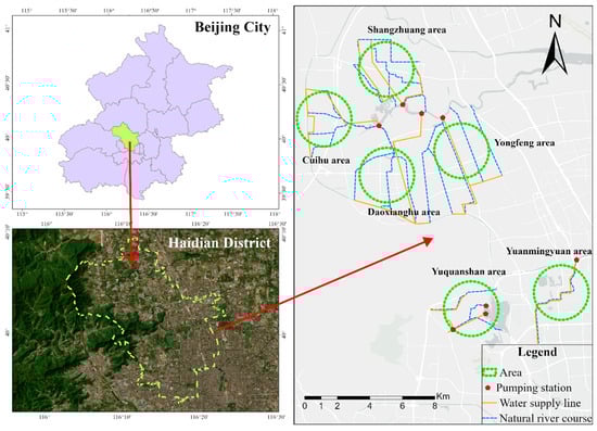
Figure 1.
Distribution of ecological water replenishment areas and replenishment pipelines in Haidian District.
In the southern region, the daily maximum water extraction capacity of the Yuquanshan area is 211,000 cubic meters, while the Yuanmingyuan area has a daily maximum water extraction capacity of 52,000 cubic meters. The total daily water extraction capacity of the two areas reaches 263,000 cubic meters. This has enabled the cyclical water replenishment of seven rivers in the “three mountains and five gardens” area, increasing the river water surface by 39.46 hectares and adding 17.3 hectares of water surface in areas such as Yinghulou Park around Yuyuanshan, helping to replenish the surrounding groundwater and restore the historical water system landscape of the “three mountains and five gardens” area. In the northern region, the total daily water extraction capacity of the Cuihu, Daoxianghu, Yongfeng, and Shangzhuang areas can reach 432,900 cubic meters. A total of 40.75 km of pipelines will be laid across the four areas, achieving cyclical water replenishment of 20 rivers in the Nansha River Basin. This will increase the river water surface by 114.92 hectares and the wetland water surface by 37 hectares, establishing a solid water ecological foundation in the northern part of Haidian.
2.2. Methods
Due to the lack of long-term monitoring data for the ecological water replenishment channels in Haidian District, traditional methods, such as the Tennant method [8] and the QP method, cannot be used for flow analysis. According to the Specification for Calculation of Ecological Flow for Rivers and Lakes (SL/T 712-2021 [9]), “for rivers with significant seasonal flow variations, ecological flow should be calculated using multiple methods and determined through reasonability and feasibility analysis”. Based on field investigations, this study sought to meet ecological base flow requirements while accommodating the landscape functionality of the channels as much as possible. Ecological flow or water depth was ultimately determined using the literature method, Rainfall-Runoff method [10], and R2cross method [11], selecting the maximum value among the three. On the basis of theoretical analysis, to ensure the practical feasibility of the plan, we further combined field investigations, fully considered the balance between ecological flow requirements and the landscape function requirements of ditches, and used a hydrodynamic model to simulate and optimize the intelligent scheduling of water pumps. This process took energy conservation, emission reduction, and intelligent scheduling as its core objectives, proposed specific ecological water replenishment flow processes, and provided targeted recommendations and guidance for practical implementation. However, the methods used in this study still have certain limitations. First, the Literature method relies on existing research results, and its applicability may be limited by regional differences. Second, the calculation results of the Rainfall-Runoff method are affected by the spatiotemporal representativeness of measured data. Due to the lack of long-term monitoring data, it may lead to certain uncertainties. Third, the R2-Cross method is based on river channel geometric parameters and assumed habitat requirements, and may not fully consider the dynamically changing hydrological conditions.
Furthermore, due to the incomplete construction of the Shangzhuang area during the study period, field investigations and model development could not be conducted. Consequently, the Shangzhuang area is excluded from the analysis in the subsequent sections.
2.2.1. Literature-Based Method for Determining Ecological Water Depth
Through comprehensive and in-depth literature research, a typical ecological water depth scheme was selected from numerous options, which had the widest coverage and the highest application frequency, providing a solid data foundation for this study. A detailed analysis of the water requirements for landscape features revealed that when the water depth reaches 15 cm or more, it significantly enhances the visual effect of the landscape and plays a positive role in maintaining the ecological balance of a river. Further research showed that when the water depth exceeds 30 cm, a critical threshold, the species diversity of an aquatic ecosystem is significantly improved [12]. This water depth condition creates a more suitable habitat for various aquatic organisms, promoting the healthy development of the ecosystem. This finding not only highlights the core role of the 30 cm water depth in maintaining biodiversity, but also underscores its significance in preserving ecological balance, providing scientific evidence for the ecological water replenishment design of urban rivers.
2.2.2. Method for Determining Ecological Flow Based on Rainfall-Runoff Method
This study is based on the traditional and classic Rainfall-Runoff calculation method [13], relying on its extensive application history and mature theoretical framework to provide scientific support for ecological water replenishment design. During the calculation process, multiple key hydrological factors need to be considered, as these factors collectively determine the operational state of a river ecosystem. The watershed area is a core parameter affecting the total amount and distribution characteristics of water resources, and its size directly determines the availability of water resources. River width is closely related to flow velocity and flow rate, playing an important role in hydrodynamic characteristics and resource transport capacity. River length, on the other hand, is related to the residence time of the water flow and energy consumption, significantly influencing the distribution of water volume and flow regime changes within a watershed. Base flow depth is an important indicator for maintaining a river’s basic ecological functions and water volume stability, directly impacting the healthy operation of the ecosystem. The water exchange cycle reflects the rate of water renewal and self-purification capacity, which is crucial for improving river water quality and the ecological environment. Precipitation, as a key source of water resource replenishment, along with evaporation and infiltration, jointly influence the dynamic balance of water resources. The water loss due to evaporation and the groundwater interactions caused by infiltration are critical factors to be considered in water resource management. These factors interact to form a complex hydrological system, which not only reflects the diversity of river ecological functions but also provides important foundations for scientifically formulating ecological water replenishment plans. In this analysis, a comprehensive understanding of the relationships between these factors is necessary to ensure that the plan meets the ecological needs of the river while achieving efficient use and sustainable development of water resources. The specific calculation method is shown in Figure 2.
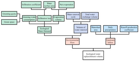
Figure 2.
Flowchart for determining ecological flow based on the Rainfall-Runoff method.
2.2.3. Ecological Water Depth Determination Method Based on Guideline Documents
Based on the authoritative and guiding standard document “Guidelines for Ecological Water Requirement Calculation of Rivers and Lakes SL/T712-2021”, which was officially implemented in the People’s Republic of China in 2021, and closely mirrors the actual situation of the research area, a scientifically reasonable ecological water requirement calculation method was selected. Among numerous calculation methods, after careful consideration, the R2-Cross method [14] was chosen. This method has unique advantages for calculating ecological water requirements the specific calculation method is shown in Table 1. According to the calculation guidelines, the series of principles and parameter requirements they stipulate provide a solid theoretical basis and framework for the application of the R2-Cross method. The guidelines were developed after a comprehensive consideration of the diversity, complexity, and long-term practical experience of China’s river and lake ecosystems. They provide strict and scientific guidance for data collection, processing, and method selection throughout the calculation process.

Table 1.
Standards for determining ecological flow using the R2-Cross single cross-section method.
2.2.4. Ecological Flow and Water Depth Determination Method Based on Hydrodynamic Model
The conceptual simulation of river replenishment is primarily carried out using SWMM (Storm Water Management Model), a hydrological and hydrodynamic simulation model [15] with significant application value for urban stormwater management and drainage system planning and design. This model, originally developed in the 1970s, has undergone multiple updates and improvements, becoming a classic tool for urban hydrological simulation. In this study, SWMM is used to simulate river replenishment, with ecological flow or water depth determined by the aforementioned three methods as input parameters. The simulation produces the corresponding ecological water depth for different ecological flow rates. Based on this, automatic pump station start/stop rules are established to achieve precise control of water depth, significant energy savings in pump station operation, and intelligent scheduling of pump stations. This provides scientific guidance and practical support for the implementation of subsequent automated pump control.
SWMM provides three methods for simulating the conduit (river) runoff process: the constant flow method, the kinematic wave method, and the dynamic wave method. The constant flow method and the kinematic wave method are simplified methods with higher computational efficiency but are generally less effective in their application. The dynamic wave method, based on the complete one-dimensional St. Venant flow equation, provides the best application results. The control equation for the dynamic wave method is the complete St. Venant equation, as shown below:
In the equation, represents the flow rate (m3/s), A represents the cross-sectional area of flow (m2), is time (s), is the distance (m), is the water depth (m), is the gravitational acceleration (m/s2), and is the frictional slope, calculated using the Manning formula:
In the equation, represents gn2, where n is the Manning’s roughness coefficient of the pipe; is the hydraulic radius of the pipe (m); and is the flow velocity, with the absolute value indicating the direction of frictional resistance opposite to the direction of flow (m/s).
2.2.5. Construction and Calibration of the Hydrodynamic Model
This study constructs an ecological water replenishment model for five districts in Haidian. Due to the high consistency in the model’s construction and validation processes, the Daoianghu area is selected as the representative case for designing and analyzing an ecological water replenishment scheme.
The ecological water replenishment in the Daoianghu area mainly relies on surface water from the Nansha River. Water is delivered to the starting points of Ahujiaxiang ditch, Wenquan ditch, Dongbutou ditch, Dazhai ditch, and Tuanjie ditch through a newly constructed pump station located at the southwest corner of Shangzhuang Bridge, with pipelines laid along the eastern road of the core area from north to south. The water flows downstream and returns to the Nansha River, forming a closed-looped water network. The replenishment scale reaches 147,000 cubic meters per day, covering a replenishment length of approximately 22.1 km, meeting the ecological water needs of the region.
The model construction utilizes the hydrodynamic module of SWMM. Based on the principles of mass conservation and momentum conservation, this module numerically solves the Saint Venant equations, precisely simulating the hydrodynamic characteristics of the water replenishment process. The conceptualized river replenishment network and pump station layout for the Daoianghu area are shown in Figure 3, providing reliable technical support for optimizing pump station opening and closing rules and evaluating the water replenishment efficiency.
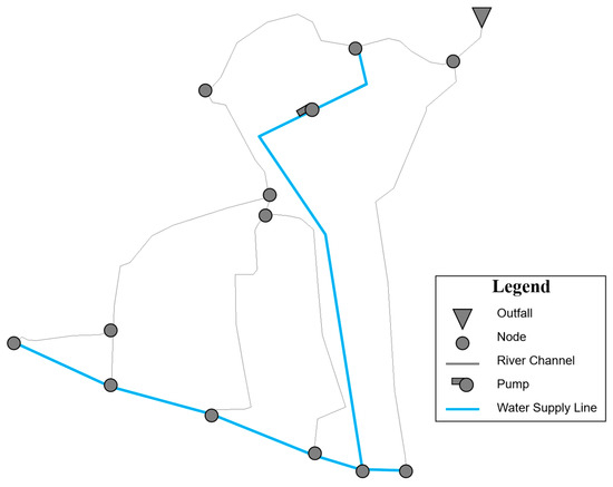
Figure 3.
Conceptual diagram of the Daxianghu area model.
On 5 June 2024, through field measurements, the actual supplement flow, water depth, and flow velocity for six areas were obtained, providing foundational data for subsequent model calibration. Among these, the data for the Daoxianghu area are shown in Table 2.
Table 2.
Measured supplementary water data for Daoxianghu area.
The model calibration was carried out using both calculated and measured results. By combining the actual measurement data and the water level monitoring devices installed along the supplementary water channels, the model was calibrated, resulting in a roughness coefficient (n) of 0.045 for the river channels; the roughness coefficient of the water replenishment pipeline was 0.015. The elevation data were derived from a 12.5-m high-precision DEM, and the river channel section data were obtained from on-site measurements. The calibration results are shown in Figure 4. According to the “Hydrological Information and Forecasting Standards” (SL 250-2000 [16]) issued by the Ministry of Water Resources of the People’s Republic of China, the Nash Efficiency Score (NES) was used as the forecast error indicator to assess the model’s accuracy. The NES for water levels at Zhoujiaxianggou and Dazhaiqu were 0.83 and 0.85, respectively, indicating the model’s reliability.
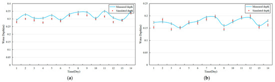
Figure 4.
Fitting of water level monitoring points at (a) Zhoujiaxianggou and (b) Dazhaiqu.
3. Results, Analysis, and Discussion
3.1. Ecological Water Replenishment Scheme
The ecological water replenishment volumes for the rivers were calculated using the literature method, the Rainfall-Runoff method, and the R2-Cross method. Among these, the literature method is primarily used to determine the required water depth, while the latter two are used to calculate the ecological water replenishment flow rates. To address the limitations of the individual methods, a hydrodynamic model was introduced to integrate the results from the three methods. Specifically, for the literature method, the model was used to derive the corresponding ecological flow rates; for the rainfall-runoff method and the R2-Cross method, the model calculated the water depths corresponding to the flow rates, enabling the conversion and alignment between the water depth and flow rate. After completing the simulation, the results from the multiple methods were synthesized to plot a flow–envelope curve, ultimately determining the recommended ecological water replenishment flow rate for each channel, thus providing a scientific basis for river ecological regulation. The calculation results of the three methods are shown in Table 3.
Table 3.
Results of ecological water replenishment volume calculations using three methods.
By comparing the ecological flow rates determined using the three methods with the actual measured values, significant increases in both the water depth and flow rate were observed. This indicates that the current ecological water replenishment capacity is insufficient to meet the river’s landscape and ecological water requirements. Additionally, the energy consumption of the pump stations under the same replenishment conditions was calculated based on the hydrodynamic model.
The three methods used in this study each have their advantages and limitations. Only by combining them in a complementary manner can we more effectively address the issue of calculating the replenishment volume for the ecological water replenishment network in Haidian District. From the final results, it can be seen that the Rainfall-Runoff method contributes relatively little to the overall replenishment effect. The actual values of the envelope curve are primarily determined by the literature method and the R2-Cross method. This also indicates that the local Rainfall-Runoff capacity in Haidian is relatively poor, making it difficult to meet the current landscape water demands of the river, which highlights the necessity of ecological water replenishment. Furthermore, the literature method relies more heavily on empirical values, and its applicability to the Haidian area remains to be verified. However, the final results demonstrate that this method has certain practical value. By introducing the R2-Cross method as a supplement, we achieve a perfect combination of experience and theory, improving the objectivity and interpretability of the results.
The results indicate that the ecological water replenishment volumes for the Cuihu, Daoxianghu, and Yongfeng areas need significant increases, as the recommended replenishment values for most of the channels are much higher than the measured values, as shown in Table 4. Among them, the recommended replenishment values for the Dazhai and Youyi channels exceed the measured values by more than 70%, suggesting that the current water volumes in these channels are significantly insufficient and cannot meet the basic ecological needs. This finding is consistent with the actual conditions observed on-site. In contrast, the measured water replenishment volumes in the Yuxianshan and Yuanmingyuan areas are sufficient, balancing the landscape and ecological needs, which is why their recommended replenishment values are relatively lower.
Table 4.
Comparison of measured values and recommended values for each area.
With an increase in the water replenishment, the energy consumption of the pump stations will inevitably rise significantly. To effectively control the pump station energy consumption while ensuring the water replenishment of the landscape, a smart control strategy for the pump stations could be employed. This strategy would dynamically adjust the pump station’s water replenishment capacity based on the river water levels, achieving a win-win situation for both energy conservation and landscape effectiveness.
3.2. Ecological Water Replenishment Scheme Based on Intelligent Dispatching of Pumping Station
The smart scheduling of pump stations plays a critical role in ecological water replenishment for urban rivers, and is an integral part of smart city development. Its application has already yielded significant results in several cities [17,18]. Through smart scheduling, water resource allocation can be dynamically adjusted based on real-time monitoring data, providing a unified water resource management platform and scientific decision-making support, effectively promoting the intelligent utilization of urban water resources [19]. Meanwhile, the use of smart scheduling has also significantly reduced pump station operational costs and energy consumption, optimized equipment start–stop frequencies and operational efficiency [20], minimized errors from manual interventions, and contributed to the sustainable development of urban water resource management.
In addition, a smart scheduling system can alleviate issues, such as flooding during the rainy season and river channels drying out during the dry season [21]. By integrating weather forecasts and hydrological data for analysis, it enables pre-scheduling, improving the flood prevention capacity while balancing ecological water replenishment. The system not only maintains real-time compliance with river water quality standards and ecosystem stability, but also reduces eutrophication, optimizes the habitat for aquatic plants and animals, and effectively enhances water resource utilization efficiency, achieving precise distribution and dynamic regulation.
The ecological base flow refers to the minimum flow required to maintain the functioning of an aquatic ecosystem and biodiversity. According to the “Study on the Ecological Replenishment Plan for the Nansha River Basin”, reviewed in 2016, the minimum water depth for replenishment is set at 15 cm to ensure the basic ecological needs of a river. At the same time, the maximum water depth for replenishment is determined according to the previously established ecological water depth standards.
In the SWMM, pump stations are defined as special types of links connecting two nodes, with their operation described by pump curves. The operation of pumps can be further controlled using logical control rules, which dictate their on/off status based on dynamic conditions, such as water levels or flow rates. Additionally, the SWMM calculates energy consumption and efficiency based on pump performance curves and operational data, allowing for a detailed analysis of pump energy use. Dynamic hydraulic calculations are employed to determine a pump’s discharge and head during simulations, accounting for its interaction with the overall drainage network.
In practical operations, when the river water depth falls below the minimum required depth, the pump station is activated to replenish the water. When the water depth exceeds the recommended depth, the pump station stops replenishing. This control rule ensures the ecological needs of the river and landscape are met while maximizing the energy savings of the pump station. Based on previous water replenishment experience in Haidian District, the dynamic management of ecological water replenishment should be implemented to ensure the safety and smooth flow of rivers during the flood season. After a heavy rain warning is issued by Beijing, ecological water replenishment operations should immediately stop, freeing up flood storage space in the river and reducing the potential safety risks caused by rain and flood overlap. This emergency measure would not only effectively relieve the pressure on flood management during heavy rainfall, but also ensure the overall operational efficiency of the urban drainage system. The water replenishment control conditions for different channels are provided in Table 5.
Table 5.
River pump station on/off water levels.
By using the SWMM model to design the pump station operation rules, the on/off times of the pump stations and the dynamic changes in river water levels and depths can be accurately simulated and calculated, resulting in more refined and visualized outputs. These visualized data not only intuitively demonstrate the effectiveness of ecological water replenishment but also provide a scientific basis for the daily management and regulation of pump stations. The replenishment processes for different channels are shown in Figure 5, Figure 6, Figure 7, Figure 8 and Figure 9. Compared to the current operation mode, where pump stations run continuously, the intelligent scheduling method significantly reduces the actual operating hours of the pump stations, achieving the goal of energy consumption reduction. Table 6 illustrates the daily energy consumption of the pump stations under the different scenarios. Although the recommended values are significantly higher than the measured values, optimization effectively controls and reduces energy consumption. Notably, the energy consumption of the pump station in the Yuquanshan area decreases by 21.8% after optimization. This scheduling method optimizes the water replenishment efficiency while effectively balancing the energy consumption with the ecological water replenishment requirements of a river.
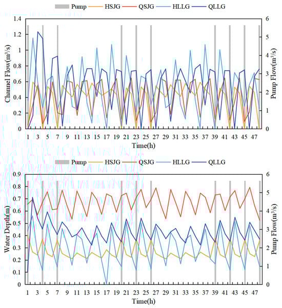
Figure 5.
Comparison of pump station flow, channel flow (up), and water level (down) in the Cuihu area.
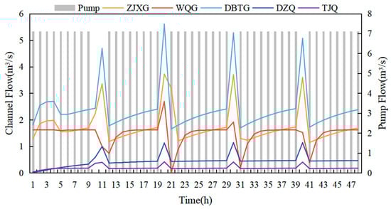
Figure 6.
Comparison of pump station flow, channel flow (up), and water level (down) in the Daoxianghu area.
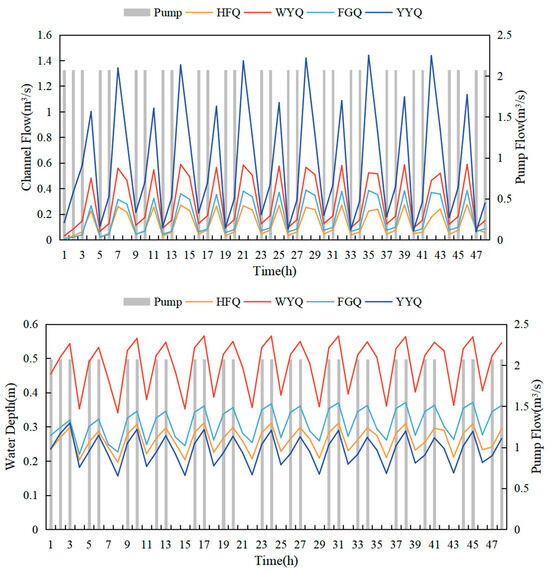
Figure 7.
Comparison of pump station flow, channel flow (up), and water level (down) in the Yongfeng area.
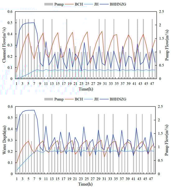
Figure 8.
Comparison of pump station flow, channel flow (up), and water level (down) in the Yuquanshan area.
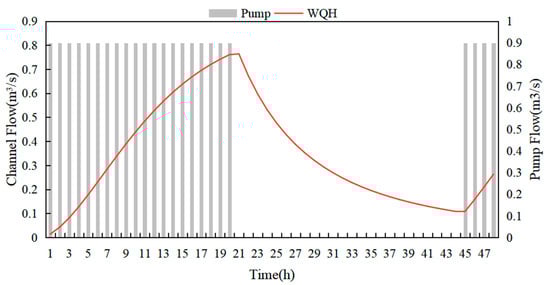
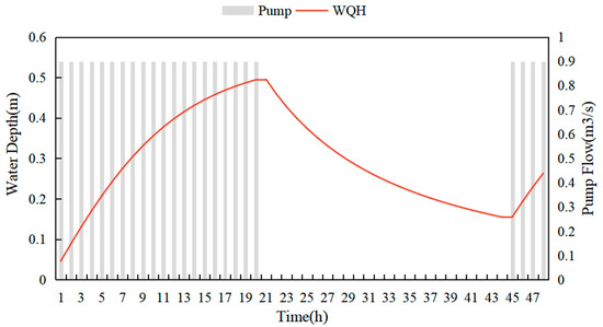
Figure 9.
Comparison of pump station flow, channel flow (up), and water level (down) in the Yuanmingyuan area.
Table 6.
Comparison of pump station energy consumption under different scenarios.
The results indicate that controlling a pump station’s on/off status based on the target channel water level can indeed achieve energy savings and effectively maintain river water levels. However, there are still notable issues. First, due to the limitations of the model, the pump station is oversimplified. Based on field surveys, it was found that different areas have multiple pumps at each station to achieve a “few active, some standby” approach, and the standby pumps can be flexibly activated based on demand. Although the model allows for the setting of multiple pumps, it cannot achieve the goal of starting or stopping pumps based on the operation of other pumps. Therefore, all the pumps are simplified as a single pump, and the number of active pumps is controlled through flow management. Second, it is clear from the results that the pump station only has two states: on and off. In some areas, such as Cuihu, Daoxianghu, and Yongfeng, the on/off intervals for pumps are too short, which is not only unfavorable for pump maintenance but also unrealistic in practice. Each pump has a performance curve that allows for the automatic adjustment of the pump output based on the actual conditions. However, in management and practice, the specific model and performance details of the pump stations are unclear, preventing the input of accurate performance curves. As a result, the simulation is carried out using a binary on/off approach. In future research, if the pump station data can be improved, the simulation of the pumps will become more accurate.
4. Conclusions
This study conducts an in-depth exploration of the determination of non-perennial river ecological flow in Haidian District, employing a combination of the literature method, Rainfall-Runoff method, and R2-Cross method, alongside a hydrodynamic model, to establish the ecological flow and water depth standards applicable to the rivers in this region. Specifically, through a detailed analysis of the rivers in different areas, clear and targeted ecological water replenishment flow values are formulated for numerous channels, in areas such as Cuihu, Daoxianghu, and Yongfeng, providing a quantitative basis for actual ecological water replenishment efforts. Additionally, an innovative ecological water replenishment plan based on the intelligent scheduling of pump stations is proposed, with precise water replenishment start/stop rules. The implementation of this rule effectively ensures both the ecological base flow and landscape requirements of the river, while optimizing energy consumption and ensuring safe and smooth flood discharge during the flood season.
The research outcomes hold significant importance for the restoration and improvement of the aquatic ecological environment in Haidian District. On the one hand, they could contribute to restoring the natural ecological functions of rivers, providing suitable habitats for aquatic organisms, and thereby enhancing biodiversity. On the other hand, they could significantly improve the overall ecological quality of the city, creating a more beautiful, water-friendly, and livable environment, offering residents better ecological spaces. At the same time, the research provides a solid and reliable basis for urban water resource management departments for formulating scientific and reasonable water replenishment strategies and for daily water resource management practices, promoting precision and a scientific approach to the development of water resource management practices.
Particularly noteworthy is the development of intelligent pump station control. Currently, due to hardware issues, pump stations in various areas are offline and cannot remotely control the output flow. Flow adjustments are made manually, which severely limits the realization of intelligent control. Future efforts should focus on addressing this issue by actively advancing the integration of the Internet of Things (IoT) and big data technologies into ecological water replenishment systems. By leveraging IoT technology, pump station equipment and other related facilities can be interconnected, enabling the real-time collection of various data, such as equipment operating status, water levels, and flow rates, also facilitating the optimization of replenishment strategies. For example, based on real-time monitoring data and historical analysis results, replenishment flow rates and times could be dynamically adjusted according to the non-perennial, time-of-day water demands and the actual river conditions, ensuring the efficient allocation of water resources. By applying these technologies, the operational efficiency, management level, and intelligence of an ecological water replenishment system could be further improved, providing stronger support for the sustainable development of urban water ecosystems.
Although there are some shortcomings in the simulation process, the objectives and results achieved are valuable. The simulation provides a reference for calculating the ecological flow requirements and simulating pump operations in areas with limited data. Additionally, managers could input specific scenarios based on actual needs and use the model’s predictive function to evaluate water replenishment strategies under unknown conditions. In the case of extreme weather or special flow requirements, the SWMM could quickly simulate the effects of water replenishment and changes in river water depth, offering effective support for emergency decision-making and long-term planning. This model-based dynamic prediction and optimization design lays the technical foundation for the intelligent management of pump stations and the scientific formulation of ecological water replenishment strategies.
In conclusion, this research provides essential theoretical foundations and practical guidance for non-perennial river ecological water replenishment in Haidian District, while also indicating directions for future studies. Through continuous improvement and innovation, it is expected that a more comprehensive, efficient, and intelligent ecological water replenishment system will be established, ensuring the sustainable and healthy development of urban water ecosystems.
Author Contributions
Conceptualization, J.C. and Z.Z.; Methodology, Z.T. and J.C.; Software, Z.T.; Validation, Z.T.; Formal analysis, Z.T.; Investigation, Z.T., K.Y. and M.M.; Resources, J.C.; Data curation, Z.T., K.Y. and M.M.; Writing—original draft, Z.T.; Writing—review & editing, J.C., Z.Z., Y.Z., T.Z., K.Y., M.M. and Y.W.; Visualization, Z.T.; Supervision, J.C. and Z.Z.; Project administration, J.C. and Z.Z.; Funding acquisition, Y.Z. and Y.W. All authors have read and agreed to the published version of the manuscript.
Funding
This research was funded by a Major Science and Technology Project of the Ministry of Water Resources (SKS-2022070), the Joint Major Project of “Science and Technology +Water-Conservancy” in Jiangxi Province (2022KSG01007), ecological water replenishment and circulation water network control model service in Haidian District (Z0203702024), and by the project of key technology for ecological restoration of rivers and lakes (CSCEC-2022-K-36).
Institutional Review Board Statement
Not applicable.
Informed Consent Statement
Not applicable.
Data Availability Statement
The data that support the findings of this study are available from the corresponding author upon reasonable request.
Conflicts of Interest
Authors Yunfu Zhang and Ying Wang were employed by the company China Construction Eco-Environmental Group Co., Ltd. The remaining authors declare that the research was conducted in the absence of any commercial or financial relationships that could be construed as a potential conflict of interest.
References
- Yuan, K.; Chu, J.; Zhou, Z.; Liu, J.; Chen, Y.; Wang, Y.; Tang, Z. Identifying Non-Perennial River Reaches: A Hybrid Model Combining WEP-L and Random Forest. Sustainability 2024, 16, 10543. [Google Scholar] [CrossRef]
- Yamin, L.; Lizhi, Z.; Jun, L.; Bing, Z. Ecological water replenishment effect in Hutuo River and driving factors. Chin. J. Ecol. 2024, 43, 3423–3432. [Google Scholar] [CrossRef]
- Lyu, K.; Dong, Y.; Lyu, W.; Zhou, Y.; Wang, S.; Wang, Z.; Cui, W.; Zhang, Y.; Zhang, Q.; Cui, Y. Data-driven and numerical simulation coupling to quantify the impact of ecological water replenishment on surface water-groundwater interactions. J. Hydrol. 2025, 649, 132508. [Google Scholar] [CrossRef]
- Zhang, X.; Duan, B.; He, S.; Lu, Y. Simulation study on the impact of ecological water replenishment on reservoir water environment based on Mike21—Taking Baiguishan reservoir as an example. Ecol. Indic. 2022, 138, 108802. [Google Scholar] [CrossRef]
- Sun, B.; Li, N.; Wang, G.; Gao, X.; Zhou, X.; Kong, F. Contribution for lake phytoplankton community succession under multi-source artificial hydrological regulation. J. Environ. Manag. 2024, 372, 123351. [Google Scholar] [CrossRef] [PubMed]
- Hao, P.; Yang, J.; Liu, X.; Strokal, M.; Wijk, D.v.; Bai, Z.; Ma, L. Optimizing nitrogen management for pollution control in Lake Baiyangdian following water replenishment. J. Environ. Manag. 2024, 372, 123374. [Google Scholar] [CrossRef] [PubMed]
- Zhang, M.; Jiang, H.; Zhu, M.; Chen, P. Study of nitrogen removal from micro-polluted surface water by the sulfur-iron autotrophic denitrification CRI. In Proceedings of the Fifth International Conference on Green Energy, Environment, and Sustainable Development (GEESD 2024), Mianyang, China, 28–30 June 2024; Volume 13279. [Google Scholar]
- Jiang, W.; Zhuang, W.; Wen, C.; Pang, Y.; Chao, J. Calculation of ecological water replenishment in small coastal watersheds based on environmental capacity constraints: A case study of eastern Xiamen, China. Ecol. Indic. 2023, 155, 111034. [Google Scholar] [CrossRef]
- SL/T 712-2021; Standards for Calculating Water Requirements for River and Lake Ecological Environments. Ministry of Water Resources the People’s Republic of China: Beijing, China, 2021.
- Worthington, T.A.; Brewer, S.K.; Vieux, B.; Kennen, J. The accuracy of ecological flow metrics derived using a physics-based distributed rainfall-runoff model in the Great Plains, USA. Ecohydrology 2019, 12, 17. [Google Scholar] [CrossRef]
- Liu, C.M.; Zhao, C.S.; Xia, J.; Sun, C.L.; Wang, R.; Liu, T. An instream ecological flow method for data-scarce regulated rivers. J. Hydrol. 2011, 398, 17–25. [Google Scholar] [CrossRef]
- Pan, Y.; Chun, T.; Jun, Z.; Zhichao, M.; Weiyi, Z.; Jia, W.; Shijin, M. Research on Water Supply Under the Protection ofRiver Ecological Water Supply and Landscape Effect. In Proceedings of the 4th First General Meeting and Academic Exchange Conference of the Building Water Supply and Drainage Research Branch of the Architectural Society of China, Xiamen, China, 27 August 2022; p. 5. [Google Scholar]
- Hager, W.H. A simplified hydrological rainfall-runoff model. J. Hydrol. 1984, 74, 151–170. [Google Scholar] [CrossRef]
- Jin, X.; Yan, D.; Wang, H.; Zhang, C.; Tang, Y.; Yang, G.; Wang, L. Study on integrated calculation of ecological water demand for basin system. Sci. China-Technol. Sci. 2011, 54, 2638–2648. [Google Scholar] [CrossRef]
- Yazdi, J.; Kim, J.H. Intelligent Pump Operation and River Diversion Systems for Urban Storm Management. J. Hydrol. Eng. 2015, 20, 04015031. [Google Scholar] [CrossRef]
- SL 250-2000; Specification for Hydrological Information Forecast. Resources the People’s Republic of China: Beijing, China, 2000.
- Zhou, W.; Liao, W. Optimization of Ecological Dispatch and Hydrodynamic Improvements in Tidal River Channels Using SWMM Modeling: A Case Study of the Longjin Yangqi Area in Kurama Mountain. Water 2024, 16, 3336. [Google Scholar] [CrossRef]
- Sunela, M.I.; Puust, R. A visual tool to calculate optimal control strategy for non-identical pumps working in parallel, taking motor and VSD efficiencies into account. Water Sci. Technol.-Water Supply 2015, 15, 1115–1122. [Google Scholar] [CrossRef]
- Ganora, D.; Isacco, S.; Claps, P. Framework for Enhanced Stormwater Management by Optimization of Sewer Pumping Stations. J. Environ. Eng. 2017, 143, 04017025. [Google Scholar] [CrossRef]
- Yazdi, J.; Choi, H.S.; Kim, J.H. A methodology for optimal operation of pumping stations in urban drainage systems. J. Hydro-Environ. Res. 2016, 11, 101–112. [Google Scholar] [CrossRef]
- Lu, C.; Lyu, J.; Yan, W.; Guo, P.; Fu, X.; Mu, D.; Luo, P.; Zhang, Y.; Huo, A. Environmental Regulation and Stormwater Management Strategies for an Urban River in Northwest China: A Sustainable Approach. Water 2024, 16, 1115. [Google Scholar] [CrossRef]
Disclaimer/Publisher’s Note: The statements, opinions and data contained in all publications are solely those of the individual author(s) and contributor(s) and not of MDPI and/or the editor(s). MDPI and/or the editor(s) disclaim responsibility for any injury to people or property resulting from any ideas, methods, instructions or products referred to in the content. |
© 2025 by the authors. Licensee MDPI, Basel, Switzerland. This article is an open access article distributed under the terms and conditions of the Creative Commons Attribution (CC BY) license (https://creativecommons.org/licenses/by/4.0/).