Article

Site Suitability Assessment for Microalgae Plant Deployment in Saudi Arabia Using Multi-Criteria Decision Making and the Analytic Hierarchy Process: A Spatial Approach

by
Mohamad Padri
1,*,
Misdar Amdah
2,
Maisarah Munirah Latief
2 and
Claudio Fuentes-Grünewald
1,*
1
King Abdullah University of Science and Technology, Beacon Development Department (KAUST-KBD), Thuwal, Makkah 23955-6900, Saudi Arabia
2
Geography Department, Faculty of Mathematic and Natural Sciences, Makassar State University, Parantambung Campus, Daeng Tata Street, Makassar 90224, Indonesia
*
Authors to whom correspondence should be addressed.
Sustainability 2025, 17(23), 10480; https://doi.org/10.3390/su172310480 (registering DOI)
Submission received: 2 October 2025 / Revised: 14 November 2025 / Accepted: 18 November 2025 / Published: 22 November 2025
(This article belongs to the Special Issue Agriculture, Food, and Resources for Sustainable Economic Development)

Abstract

Microalgae cultivation presents a promising pathway for sustainable agricultural development in arid environments by minimizing freshwater consumption. In Saudi Arabia, where agricultural expansion coincides with extensive coastal resources, algal biotechnology has emerged as a strategic approach to optimize resource use. This study applies a Geographic Information System (GIS)-based framework integrating the Analytic Hierarchy Process (AHP) within a Multi-Criteria Decision-Making (MCDM) approach to evaluate the suitability of coastal zones for seawater-based microalgae cultivation. Suitability assessment incorporated topography, land use, seawater accessibility, proximity to CO2 emission sources, nutrient availability, and key environmental parameters. The analysis focused on a 24,771 km2 area of interest (AOI) extending from the coastline to the nearest highway. The results indicate that 56% of the AOI is suitable for cultivation, including 4728 km2 classified as highly suitable and 1606 km2 as very highly suitable, predominantly located near industrial CO2 sources and wastewater treatment facilities. Areas with lower suitability remain feasible for cultivation through targeted resource management. These findings highlight the significant potential for large-scale microalgae production in Saudi Arabia, contributing to sustainable biotechnology development and agricultural diversification under the country’s Vision 2030 strategy.

1. Introduction

Saudi Arabia, with its extensive coastlines, high solar irradiance, and vast non-arable desert land, presents a strategic opportunity for large-scale cultivation systems capable of utilizing saline water and marginal land resources. Geographically, the country possesses vast saline water reserves from both the Red Sea and the Arabian Gulf, with coastlines extending 1760 km and 560 km, respectively [1]. The climate of Saudi Arabia experiences significant temperature variations, ranging from −10 °C to 52 °C [2], and These coastal zones are primarily characterized by flat and semi-flat terrain [3], provide promising locations for cultivation systems that can operate under extreme environmental conditions.
Microalgae, as photosynthetic microorganisms, are valued for their capacity to synthesize bioactive compounds such as proteins, carbohydrates, and essential nutrients, making them an important resource for animal feed and nutritional applications [4,5]. Their ability to maintain growth and productivity under diverse conditions, while utilizing a wide range of nutrient sources, makes them a viable alternative to conventional feed ingredients, thereby reducing reliance on imported protein sources. Moreover, they can be cultivated on non-arable land using saline, brackish, or wastewater [6,7], and their tolerance to high salinity and temperature extremes enhances their suitability for arid and semi-arid regions [8]. Large-scale cultivation can also contribute to carbon sequestration, with potential to significantly mitigate global CO2 emissions [9].
Successful microalgae cultivation requires optimal combinations of light, nutrients, and water. While sunlight is the primary energy source, essential nutrients such as carbon, nitrogen, and phosphorus can be obtained from industrial CO2 emissions or organic feedstocks including sodium bicarbonate and molasses [10]. Wastewater can also supply nutrients, enabling integration of biomass production with wastewater treatment [11]. In Saudi Arabia, industrial CO2 emissions amount to approximately 709.79 metric tons annually, with over 50% originating from point sources potentially available for cultivation [12] and relatively low electricity costs further support industrial-scale production.
Environmental and geographical factors, such as land topography, climate, wind speed, and land use, strongly influence site selection for large-scale cultivation, affecting both productivity and operational costs [13,14]. These climate factors include temperature, daylight period, light irradiation, and precipitation play pivotal roles in large scale microalgae cultivation as they affect the growth and biochemical composition of the algal biomass. Furthermore, sources of nutrients from accessible waste/flue gases are also important to consider for large scale cultivation as it can reduce the operational expenditures. Globally, studies from Australia [15], Mexico [14], the United States [16], and Thailand [17] have demonstrated how spatial analysis tools can guide optimal site selection. However, these efforts have largely focused on moderate climates and regions with abundant freshwater, while extreme arid environments remain underexplored despite their potential for saline-based cultivation. These combined environmental, biological and geographical beneficial of identifying optimal sites for microalgae cultivation explicit frameworks such as Multi-Criteria Decision-Making (MDCM) and the Analytic Hierarchy Process (AHP).
This study applied a Geographic Information System (GIS)-based multi-criteria decision-making framework using the Analytic Hierarchy Process (AHP) to evaluate site suitability. The objectives are to (1) locate potential areas for saline-based cultivation and (2) classify them according to environmental and logistical criteria relevant to sustainable large-scale deployment. The findings will offer valuable insights for similar arid, water-limited regions worldwide.

2. Study Area

The Kingdom of Saudi Arabia (KSA), covering approximately 2.25 million km2, is the largest nation in both the Arabian Peninsula and the Middle East. Its geographic profile is characterized by vast desert and arid landscapes, with a total shoreline extending over 2300 km along the Red Sea and the Arabian Gulf [1]. These coastal areas offer substantial resources for seawater-based aquaculture and microalgae cultivation.
Given Saudi Arabia’s limited freshwater resources, primarily sourced from groundwater and desalination [18], seawater and brine water were prioritized as media for microalgae cultivation. Brine water, produced as a byproduct of desalination and evaporation in open systems, serves as an alternative growth medium. Consequently, this study focuses on identifying suitable areas along the Red Sea and Arabian Gulf coastlines for large-scale microalgae production.
To establish the terrestrial boundary from the shoreline, major highways were selected as the limit for site suitability analysis. The choice was based on logistical and economic considerations, as crossing or bypassing highways for resource transportation involves complex construction procedures [19]. The Kingdom’s highway network extends approximately 45,000 km [20], with ongoing expansion driven by economic and population growth. Based on these constraints, the Area of Interest (AOI) is defined as the coastal regions between the shoreline and the nearest major highway within the Red Sea and Arabian Gulf territories of KSA.

3. Materials and Methods

Integrated Geographic Information System (GIS)-based spatial analysis with Multi-Criteria Decision-Making (MCDM) approaches to evaluate the suitability of land areas for microalgae cultivation is adopted in this study. Systematic assessment of environmental, climatic, resources, and infrastructural parameters that influence microalgae growth potential are the main considerations. By combining geospatial datasets, such as temperature, solar irradiance, proximity to seawater or wastewater sources, and land-use restrictions, with weighted decision models, this approach provides a comprehensive, data-driven evaluation of spatial suitability.
This approach is relevant for microalgae planning for identifying optimal cultivation sites without extensive field measurements throughout the country, reducing cost, accessibility limitations, and laborious coverage. This approach also supports strategic planning for selecting large areas for industrial-scale cultivation and feasibility analysis for assessing the influence of environmental constraints on productivity. The use of open-source geospatial databases and transparent weighting criteria also ensures that the model can be replicated, modified, or further developed in different regions and environmental conditions.

3.1. Data Sources

Data layers representing both enabling and restrictive factors were compiled using multiple geospatial tools. Primary software used for data acquisition and processing included Google Earth Engine (GEE) 2024 [21] and ArcGIS Pro 3.3, which facilitated spatial analysis and visualization. GEE provided access to large-scale geospatial datasets, enabling rapid data validation and cross-referencing [21], while ArcGIS Pro 3.3 supported advanced geoprocessing and environmental modeling [22].
The acquired datasets were categorized into restrictive and enabling factors for microalgae cultivation. Restrictive factors included land use classifications (residential, industrial, agricultural), terrain constraints (wadi (valley), slope, rocky surfaces), and infrastructure limitations (highways, railways, electrical grids). Enabling factors comprised proximity to seawater, wastewater treatment plants, industrial carbon dioxide sources, and climatic conditions such as wind speed, temperature, and solar irradiance. All the data were obtained from the open-source database (Table 1).

3.2. Criteria Selection

3.2.1. Microalgae Cultivation Method Assumption

The cultivation system employed in this study consists of a hybrid approach, integrating open raceway ponds with closed photobioreactors. The method is based on the pilot-scale application of seawater microalgae cultivation that has been carried out in an open raceway system [23]. The method follows a two-step process: (1) inoculum preparation and (2) large-scale cultivation. The inoculum preparation stage occurs in a closed system to ensure high-density and contamination-free cultures before their transfer to the open raceway ponds. Open raceway ponds are susceptible to environmental variations such as temperature fluctuations, irradiance levels, high evaporation rates, and potential contamination.
The cultivation process has been demonstrated in a production plant facility of Development of Algal Biotechnology in Kingdom of Saudi Arabia (DAB-KSA) with combination of open system and closed system cultivation (Figure S1). The scale of this production plant facility is 4 hectares, consisting of open raceway ponds with various working volumes and scaling up facility of laboratory and shaded area (Table S1). These cultivation reactors is proven to be successfully cultivated under desert environment conditions. Considering the scarcity of freshwater in the kingdom, seawater cultivation is chosen as the main water used for cultivation. Thus, distance from the sea is one of the crucial aspects in the suitability analysis.
Furthermore, in DAB-KSA project, numerous strains have been tested ranging from commercial to isolated strains from freshwater and seawater sources. Thus, in this study, the suitable microalgae strains are assumed to be seawater or freshwater algae which can be adapted to seawater. Chlorella spp., Limnospira maxima, Dunaliella salina, Tetraselmis sp., and Leptolyngbya sp. are among the widely cultivated algae [23,24,25,26,27,28].

3.2.2. Rationale of Enablers and Restrictors

A conceptual framework enables the systematic identification and organization of spatial and non-spatial factors affecting location-based decisions [29]. The selection of suitable sites for microalgae cultivation is influenced by both enabling and restrictive parameters. Enabling factors include extensive coastlines that provide abundant saline water, reducing freshwater dependency [30]. High solar irradiance in Saudi Arabia supports photosynthetic efficiency and enhances biomass productivity [31].
The integration of wastewater treatment facilities and industrial carbon capture systems can further enhance nutrient availability for microalgae [32,33]. Restrictive factors such as electrical grids, highways, and urban expansion limit land availability. Urbanization trends have significantly reduced the potential land area for microalgae cultivation [34].

3.3. Analytic Hierarchy Process (AHP) Weightage

The Analytic Hierarchy Process (AHP) remains one of the most widely used MCDM techniques due to its capacity to handle both quantitative and qualitative criteria through pairwise comparisons [35]. Multi-criteria decision analysis offers a transparent and replicable approach for integrating diverse datasets into a single site suitability assessment [36].
Each factor was assigned a weight based on its impact on the suitability for microalgae cultivation, following methodologies adapted from Lozano-Garcia et al. [14]. The total weight score (TW) was calculated using Equation (1).
T W = W ( C O 2 ,   W W ,     S , T , C , A g ) × f ( C O 2 ,   W W ,     S , T , C , A g )
In this equation, W represents the weight assigned to each factor, reflecting its importance in determining the suitability of the area for cultivation. The weight W is based on various environmental and logistical factors that influence microalgae growth, such as proximity to carbon emission sources, wastewater treatment facilities, sandstorm exposure, and temperature. Meanwhile, f denotes the factor of importance, which varies according to the relevance of each environmental parameter. These factors are quantified by assessing aspects like distance, intensity, and frequency, which are crucial to understanding the impact on cultivation feasibility.
The factors considered in the equation include CO2 (distance to carbon emission sources), WW (proximity to wastewater treatment facilities), S (sandstorm influence, based on wind speed), T (temperature conditions), C (distance from the coastline), and Ag (proximity to agricultural waste or wastewater emissions). Each enabling factor is assigned a weight based on proximity and relevance to microalgae growth, and this weight is then multiplied by its corresponding factor of importance (Table 2). The calculation of the total weight score (TW) takes into account these weighted factors, providing a composite measure of site suitability for microalgae cultivation.
The Analytic Hierarchy Process (AHP) is employed to derive weights from expert judgments through pairwise comparisons, ensuring consistency in the decision-making process [37].

3.4. Suitability Classification

It is essential to note that any occurrence of restrictive factors—such as proximity to urban areas, unsuitable terrain, or infrastructure limitations—will directly impact the total suitability score. If any restrictive factor is present in the analysis, the total weight score (TW) is set to zero, indicating that the area is unsuitable for cultivation. This ensures that only areas with favorable conditions, free from significant environmental or infrastructural limitations, are considered suitable for large-scale microalgae production. The TW scores were categorized into five suitability classes, as shown in Table 3. Incorporating spatial and temporal dimensions into decision-making processes enhances the relevance and applicability of the resulting recommendations [38].
This systematic approach ensures a precise and quantitative evaluation of potential microalgae cultivation sites, supporting informed decision-making for sustainable production.

4. Results

4.1. Area of Interest

The presented map illustrates potential sites for large-scale microalgae cultivation along the coastal regions of Saudi Arabia, specifically within the Arabian Gulf and Red Sea domains. The site suitability assessment integrates multi-criteria spatial analysis that integrates both enabling and constraining factors influencing microalgae growth and cultivation viability. This evaluation is carried out through the application of Geographic Information System (GIS) combined with Multi-Criteria Decision Making (MCDM) using the Analytic Hierarchy Process (AHP) to identify high-potential zones. This approach combines environmental, infrastructural, and geospatial parameters within a data-driven framework, optimizing site selection in alignment with both biophysical and logistical criteria.
Based on the spatial overlay analysis of designated enabler and restrictor layers, the total land area in Saudi Arabia deemed suitable for microalgae cultivation is approximately 24,771 km2. Of this, 56% is classified as optimal for algal biorefinery infrastructure development, as it is free from significant spatial constraints. The remaining 44% is considered unsuitable for large scale microalgae production due to conflicting land-use patterns, topographical constraints, or environmental limitations.
The spatial distribution of suitable land is concentrated in two primary coastal regions: the Arabian Gulf and the Red Sea. Specifically, the analysis identified 9939 km2 of high-suitability land along the Red Sea coastline and 4070 km2 along the Arabian Gulf, indicating that the Red Sea region demonstrates greater spatial potential for microalgae cultivation (Figure 1). This predominance, accounting for over 70% of the total suitable area, is primarily attributed to the extensive shoreline length and the prevalence of low-relief coastal plains with minimal land use. The spatial suitability assessment emphasizes that the high availability of undeveloped coastal terrain in these regions provides an optimal foundation for large-scale algal biomass production and related biotechnological applications.

4.2. Suitability Index

The suitability index classifies the Area of Interest (AOI) into two primary categories: suitable and non-suitable. To enhance the precision of the assessment, five distinct suitability levels are applied to characterize the land’s potential for microalgae cultivation: very low, low, medium, high, and very high. This scoring and classification system has been utilized for numerous purposes, such as soil quality [39], land-use planning [40], farm restoration [41], and other development purposes.
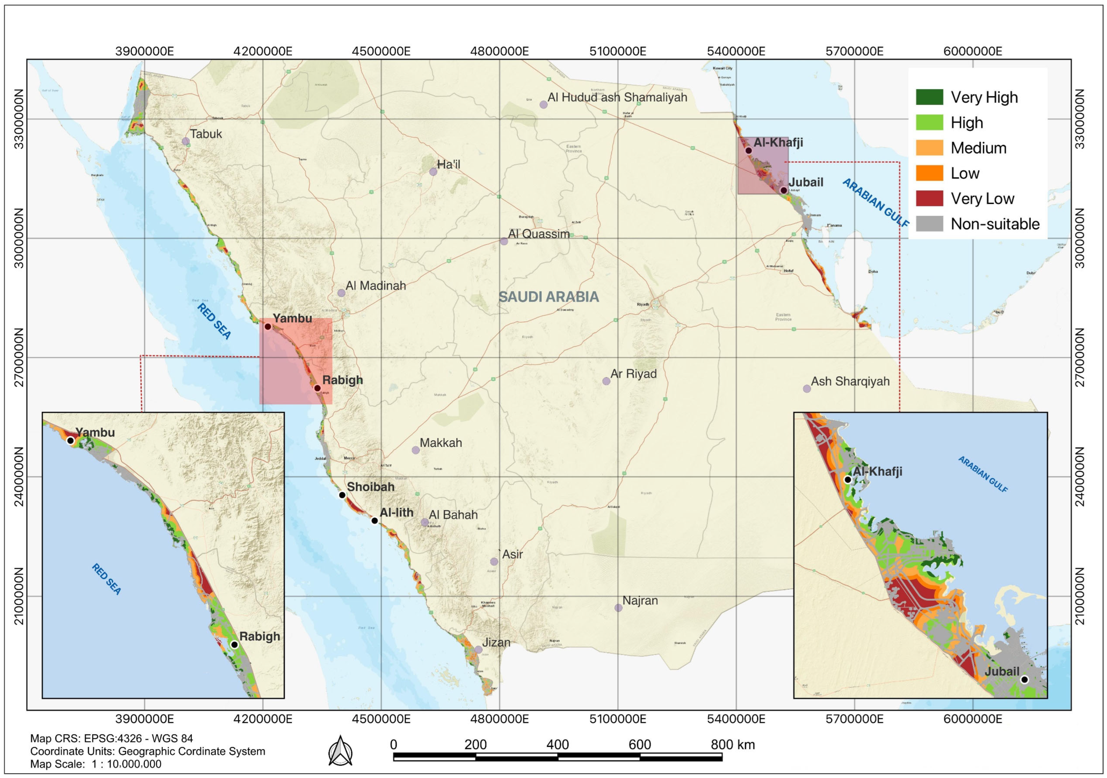
Based on a geographical perspective, the analysis encompasses a total area of 24,771 km2 across the Red Sea and Arabian Gulf coasts, identifying 14,008 km2 as suitable and 10,763 km2 as non-suitable due to land use or environmental constraints (Table 4). These spatial patterns highlight the strong interplay between physical geography and human activities. The suitable areas are further classified based on specific geospatial and environmental criteria relevant to microalgae plant development (Figure 2).
The analysis reveals that approximately 2088 km2 of coast area in the Kingdom of Saudi Arabia is classified as having very low suitability for microalgae cultivation (Table 4). This area is indicated by minimal potential due to no resources found to be advantageous for microalgae production, although no significant spatial restrictors are present. Additionally, the total low suitability area was found to be 1264 km2 while the medium suitability category covers 4322 km2. Both low and medium suitability areas are generally located in coastal regions characterized by minimum supporting resources, such as nutrient availability, freshwater inputs, and other enabling parameters necessary to enhance microalgae growth and reduce the operational cost. From a geographical point of view, these suitability patterns reflect the spatial variability of environmental and infrastructural factors along the Red Sea and Arabian Gulf coastlines.
High suitability areas in the Red Sea and Arabian Gulf regions were found to be 3701 km2 and 1027 km2, respectively. These regions are highly favorable for microalgae cultivation due to optimal environmental conditions and resource availability, allowing for suitable large-scale cultivation. The very high suitability category includes 1606 km2 within the AOI (1336 km2 and 270 km2, in Red Sea and Arabian Gulf coasts, respectively). These areas offer the best conditions for microalgae cultivation, ensuring maximum productivity and efficiency for the microalgae. These prime locations are most suited for high-yield, large-scale microalgae farming operations, as they are nearby nutrient and carbon sources, favorable temperature, and low wind speed to avoid any excessive sandstorm. Moreover, the restrictors such as unfavorable land contours are rarely found in these regions, rendering high possibility to build any construction related to the microalgae plant.

4.3. The Critical Role of Industrial Zones in Microalgae Suitability over Other Key Enablers

The suitability of a given region for large-scale microalgae cultivation is influenced by several key environmental and anthropogenic factors. Among these, three major enablers significantly impact suitability indexing: (1) industrial and mining activities that generate point-source CO2 emissions, (2) wastewater treatment plants (WWTPs) that can provide nutrient-rich effluents, and (3) agricultural sites, particularly animal farms, which contribute organic nutrient sources. These parameters are integrated into GIS-based multi-criteria decision analysis (MCDA) to determine optimal cultivation sites (Table 2). The results highlight the predominant influence of industrial zones, particularly along the Red Sea and Arabian Gulf coasts, where CO2 availability emerges as a decisive factor in determining high-suitability zones.
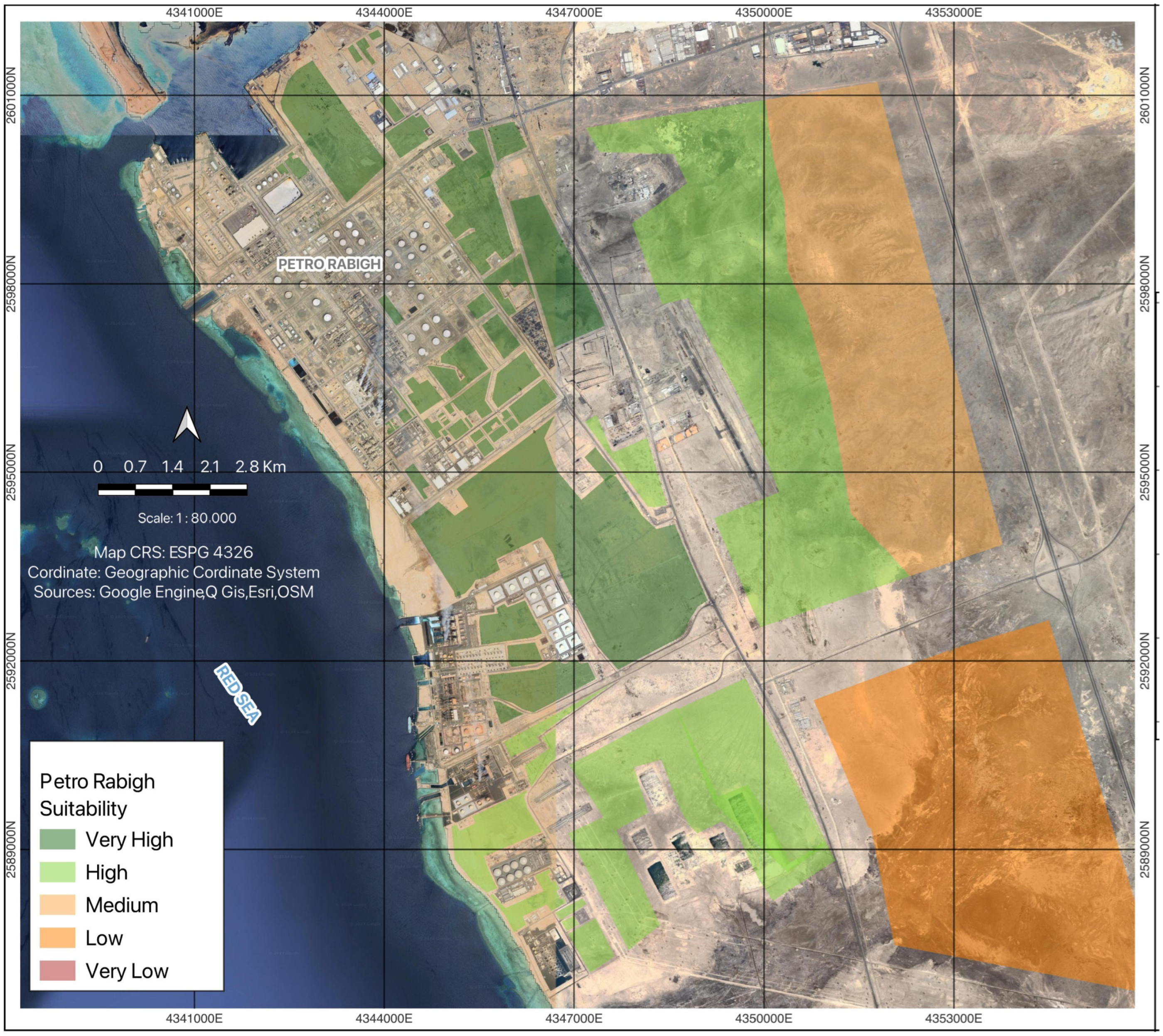
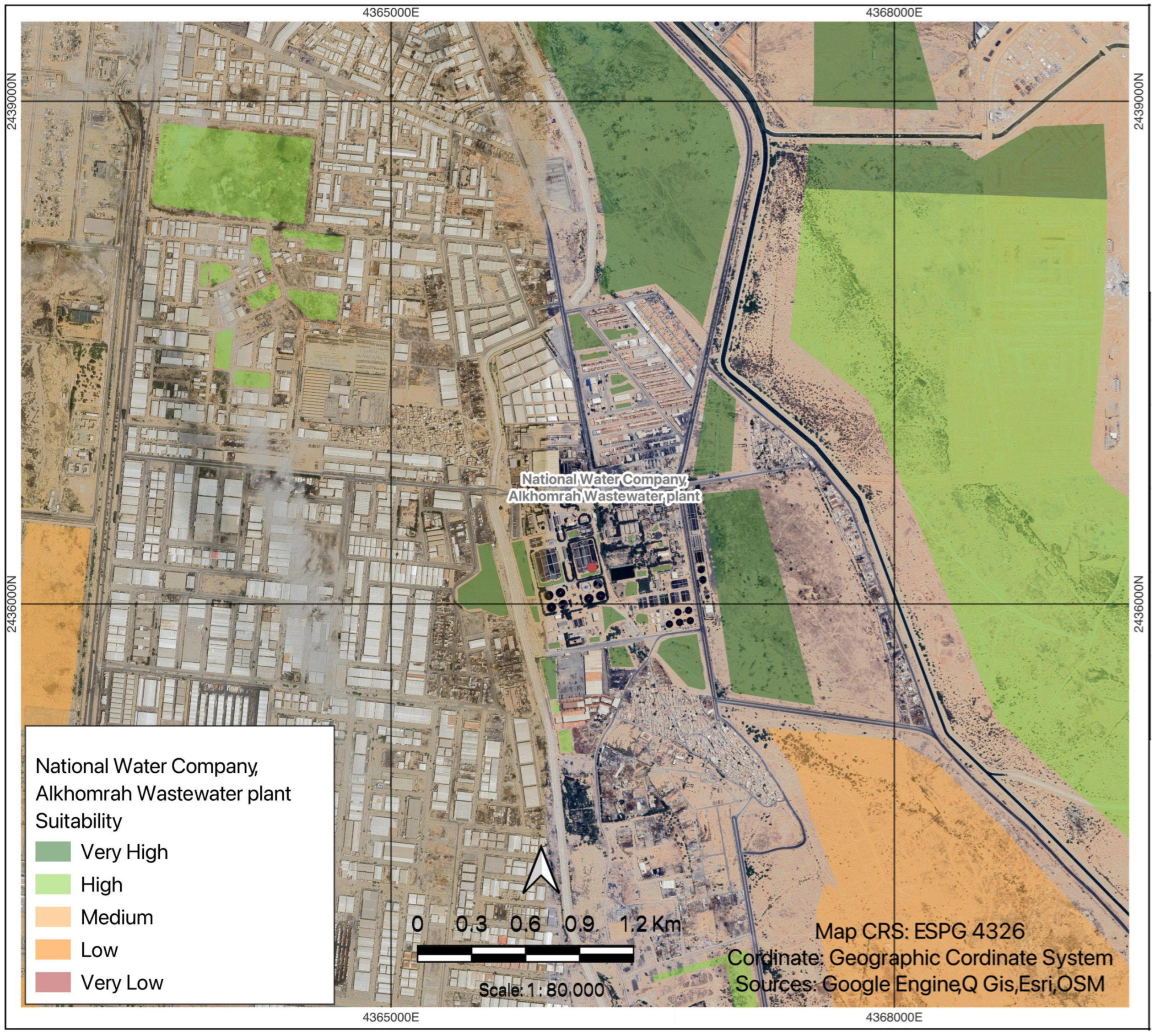
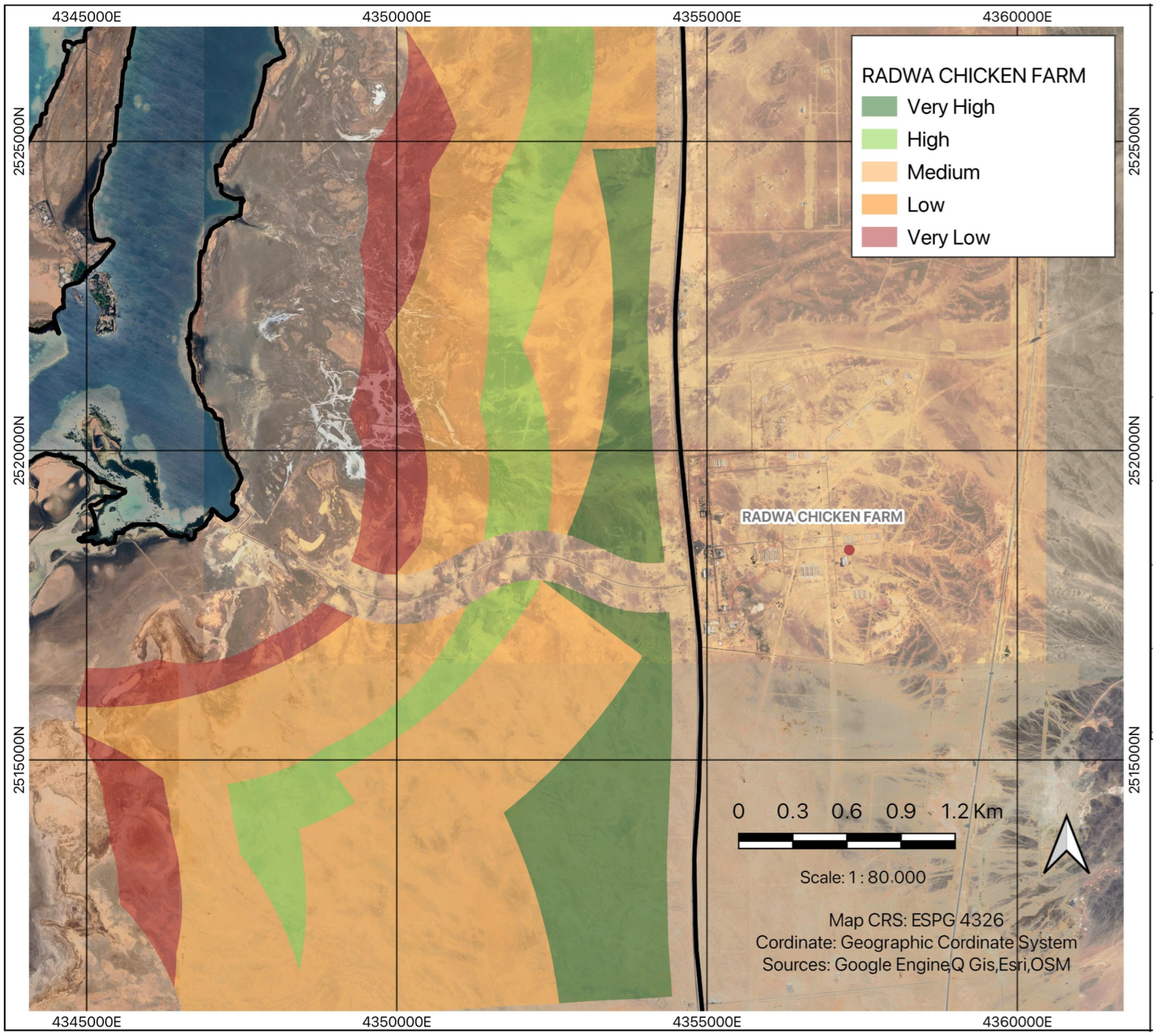
Three different examples of the effects of these enablers toward the suitability of the area for the microalgae plant can be found in Petro Rabigh nearby Rabigh city (Figure 3), Alkhomrah Wastewater plant (National Water Company) nearby Jeddah (Figure 4), and Radwa Chicken Farm managed by Radwa Company (Figure 5). The highly suitable area around Petro Rabigh covers approximately 36.56 km2 primarily due to the presence of a significant industrial zone near the city. High carbon emissions from nearby industries, combined with the availability of carbon capture and purification technologies that produce green CO2 in this area [42] are also suitable for the microalgae cultivation. This green CO2, although it is generated from fuel/coal combustion, still considered as “green” because the valorization of this flue gas can reduce the CO2 release into atmosphere and eventually reduces total greenhouse gasses emission contributing to sustainable process and at the same time reducing the production cost of microalgae biomass. Consequently, very high suitability zones are concentrated around these industrial clusters, reflecting a strong spatial correlation between industrial activity and opportunities for alga biomass production.
Overall, while wastewater treatment facilities and agricultural farms contribute to specific high-suitability patches, their overall influence remains secondary compared to industrial CO2 sources. This contrasts with other global regions where agricultural byproducts and wastewater effluents are dominant enablers for microalgae cultivation systems [43]. Consequently, in western Saudi Arabia, the prioritization of industrial CO2 emissions emerges as the primary determinant for defining microalgae facility suitability indices.
Despite these constraints, several agricultural zones still provide localized opportunities for microalgae plant development. For example, the Radwa Chicken Farm area near Jeddah demonstrates relatively high potential, with approximately 25.06 km2 identified as highly and very highly suitable despite being located outside the area of interest (AOI). However, nearby slopes and frequent high winds during sandstorm seasons impose further geographical limitations on large-scale utilization.
Agricultural areas, including livestock and aquaculture farms, are often located in regions where land-use conflicts and topographic constraints limit their potential contribution to microalgae cultivation suitability. Many of these farms are situated on higher-elevation terrain or within freshwater source zones, where available flat land is scarce for facility development. In addition, fencing and grazing practices typically occupy extensive areas, further reducing suitable land [44].

4.4. Availability of Medium, Low, and Very Low Suitability Area

Medium suitability areas cover approximately 4322 km2, while the low and very low suitability areas are identified in 2088 and 1264 km2, respectively. Several factors need to be enhanced for viable cultivation in this area with low supporting resources for microalgae cultivation [45]. For the management strategy, improvements like nutrient supplementation, water treatment systems, and protective measures against harsh environmental conditions need to be considered in these areas to build a microalgae facility there.
Although this area lacks nutrient sources and some parts experience unfavorable wind speed and temperature conditions, these categories cover a significant portion of the AOI. It is also important to note that some of these areas are connected to highways and other major transportation routes, which can help address the lack of supporting resources by facilitating the supply of construction materials and daily nutrient inputs. Water, nutrients, and CO2 are essential elements for microalgae growth, and the absence of readily available resources can increase production costs [46]. Therefore, the potential of these areas can still be enhanced through further analysis of product applications and target markets for the cultivation outputs.

5. Discussion

5.1. Comparative Analysis of Microalgae Suitability Between the Red Sea and Arabian Gulf Coasts

Saudi Arabia’s coastal regions exhibit distinct yet interconnected potentials for microalgae cultivation, with both the Red Sea Coast and the Arabian Gulf Coast identified as highly suitable zones. Although geographically separated and shaped by differing environmental dynamics, both coasts are strongly influenced by industrial and economic drivers that enhance cultivation prospects, particularly within the designated zones between the coastal line and the highway corridor. Variations in industrial density, wastewater management practices, agricultural land use, and environmental constraints further differentiate their suitability levels, shaping localized opportunities for large-scale microalgae production.

5.1.1. Common Enablers for High Suitability in Both Coasts

Both the Red Sea and Arabian Gulf coasts demonstrate high suitability for microalgae cultivation due to their industrial infrastructure and CO2 emissions, which serve as primary enablers. The results confirm that industrial activity plays a dominant role in determining site suitability, as both regions host extensive petrochemical, mining, and manufacturing industries that produce significant point-source CO2 emissions [42]. These emissions provide a stable and concentrated carbon source, directly supporting microalgae growth by enhancing photosynthetic efficiency.
Additionally, both coasts are characterized by an arid desert climate [47,48]. Limitations also arise from availability of traditional agriculture lands and wastewater treatment facilities. This reduces reliance on agricultural runoff and wastewater-derived nutrients, thereby shifting the suitability model toward industrial carbon utilization and process integration.
However, despite their climatic similarities, the two regions interact differently with wastewater treatment systems and agricultural activities, leading to significant variations in their overall suitability levels.

5.1.2. Key Differences Between the Red Sea and Arabian Gulf Coasts

Despite sharing common industrial drivers that enhance microalgae cultivation potential, the Red Sea and Arabian Gulf coasts exhibit marked differences in industrial density, wastewater infrastructure, agricultural activity, and environmental risks. These variations directly affect the availability of key growth factors, such as CO2 sources and nutrient inputs, while also shaping potential challenges related to contamination and ecosystem stability.
One of the most significant differences lies in industrial distribution and emission characteristics [42]. On the Red Sea coast, especially around Al Wajh and Al Lith, industrial expansion has focused on manufacturing and mining as part of Saudi Arabia’s diversification strategy [49]. These industries emit CO2 but at lower intensities compared to the Arabian Gulf, where petrochemical refining and energy-intensive industries dominate [42]. In areas such as Al-Khafji and Jubail, extensive oil refineries and petrochemical plants generate higher CO2 emissions per site [2], providing a consistent and predictable carbon supply that favors large-scale microalgae cultivation.
Wastewater infrastructure also shapes nutrient availability. On the Red Sea coast, wastewater treatment facilities remain limited because dominant industries consume little water [50]. Consequently, the contribution of wastewater-derived nutrients to microalgae growth remains minimal, necessitating a stronger reliance on direct CO2 supplementation rather than organic nutrient inputs. In contrast, the Arabian Gulf has a more developed wastewater treatment network, driven by higher population density and industrial water usage. However, most treated wastewater is allocated to agricultural irrigation rather than biotechnological processes, limiting its role in microalgae cultivation [51,52].
Agricultural nutrient inputs further distinguish between the two coasts. Along the Red Sea, farming activity is extremely limited due to water scarcity, low soil fertility, and hyper-arid conditions [7]. Consequently, agricultural runoff contributes little to nutrient supply, making industrial CO2 the dominant enabling factor. Conversely, the Arabian Gulf supports more controlled irrigation systems and livestock farming, especially around Al-Khafji and Jubail, which provide modest nutrient inputs from manure and irrigation discharge. However, compared to industrial CO2 emissions, agricultural contributions remain secondary in both regions.
Environmental risks present another layer of contrast. Despite ongoing industrial development, the Red Sea coast faces a lower risk of industrial pollution due to less concentration of heavy industries [53,54]. However, the region is more prone to salinity fluctuations and high evaporation rates, which could present additional challenges for microalgae system stability [55]. In contrast, the Arabian Gulf experiences greater exposure to industrial pollutants, particularly heavy metals and hydrocarbons from oil refineries and petrochemical complexes [54,56]. This risk necessitates more rigorous environmental monitoring and pollution control measures to maintain biomass quality and ecosystem health.
Overall, while both the Red Sea and Arabian Gulf coasts present strong suitability for microalgae cultivation, their differences in industrial structure, wastewater treatment, agricultural contributions, and environmental risks necessitate region-specific approaches to site selection and cultivation system design. The Red Sea coast may require a stronger emphasis on CO2 capture strategies to compensate for the lack of wastewater and agricultural nutrient inputs, while the Arabian Gulf must implement stricter pollution controls to mitigate the risks associated with heavy industrial emissions.

5.2. Comparative Analysis of Microalgae Suitability Studies in Different Regions

Several studies have assessed the suitability of different regions for large-scale microalgae cultivation, each highlighting unique environmental and logistical factors that influence feasibility. A study conducted in Mexico evaluated the potential for microalgae cultivation by considering the availability of freshwater resources [14]. While extensive suitable areas were identified, the high and very high suitability zones were often fragmented and faced environmental and logistical challenges. Similarly, a study in Australia has explored the potential for microalgae production in coastal regions and find strong suitability areas influenced by factors such as water management strategies and regulatory compliance [15]. In Iran, coastal areas along the Oman Sea and the Persian Gulf have been identified as key zones for potential microalgae cultivation, with seawater availability being a primary enabling factor [57]. The potency of water-based approach for identification the suitable areas is important in region with limited freshwater resources. Regions with extreme freshwater scarcity, for instance, face unique challenges in utilizing treated wastewater or agricultural residues for microalgae production. In many cases, site suitability for microalgae cultivation is influenced by the availability of CO2 sources, water resources, and regulatory frameworks. While some regions have well-developed policies supporting wastewater reuse in agriculture and aquaculture, others are exploring alternative strategies that align with their environmental and economic landscapes.

5.3. Limitation and Future Development

While the results highlight a vast area of potential cultivation sites, it is important to acknowledge that the method still presents several challenges. One of the primary limitations is the availability of open-source data, which is often insufficient for comprehensive suitability assessments [58]. Consequently, a significant portion of the analysis must begin with manual digitization, increasing the time and labor required for data processing for further application of this approach in other study area [59]. Furthermore, the temporal limitations of the available datasets provide constraints on real-time accuracy, as some displayed data may have a time lag of up to one year from actual field conditions. To mitigate these distortions, geometric correction processes are required to ensure that the final maps accurately reflect ground conditions [60]. Additionally, limited contextual information in many open-access datasets restricts the ability to incorporate key details, such as administrative boundaries, place names, and other relevant geographic attributes. This limitation may affect decision-making when integrating mapping outputs with policy or investment strategies. Additionally, the analysis also focuses on the suitability of the area considering the algal cultivation and nutrient sources including CO2 with no specific cost calculation for area of interest. However, by focusing on utilization of the freely available nutrient sources and avoiding any environmental limitation, cost-effective cultivation can be achieved in highly suitable areas.
Despite these challenges, the application of GIS-based suitability mapping provides substantial opportunities for enhancing microalgae cultivation planning and decision-making. One of the most significant benefits is site selection for cultivation facilities, allowing stakeholders to identify and prioritize high-potential locations for optimized resource allocation. As outlined in this study, the high and very high suitability areas span 6334 km2, offering a significant potential zone for microalgae development based on resource availability and environmental compatibility in KSA.
The results support resource management by monitoring water and CO2 availability, minimizing environmental impact, and enhancing resilience to Saudi Arabia’s extreme climate. Suitability maps also inform policies on land use, water management, and integrating microalgae cultivation into sustainable, circular economic models. Addressing the existing limitations, such as enhancing data accessibility, improving real-time monitoring capabilities, and refining geometric correction techniques, will further strengthen the role of GIS in optimizing microalgae cultivation. Future advancements in remote sensing, artificial intelligence-based spatial analysis, and integrated data systems can help overcome current constraints [61], improving both the accuracy and efficiency of suitability assessments for large-scale microalgae production.

6. Conclusions

This study highlights the significant potential of microalgae cultivation in Saudi Arabia, particularly along the Red Sea and Arabian Gulf coasts, where industrial emissions serve as a critical enabler of biomass production. A novel delineation of the area between the coastal line and highway was introduced in this study for seawater-based microalgae cultivation. GIS suitability analysis reveals that 56.54% (14,008 km2) of the assessed 24,771 km2 area of interest (AOI) is suitable with no major geographical or land-use constraints, offering viable conditions for large-scale cultivation. Of this, 1032 km2 is classified as high to very high suitability, primarily due to proximity to industrial CO2 sources, while an additional 906 km2 of lower suitability land holds potential for optimization through nutrient augmentation strategies, including wastewater and agricultural waste integration. Industrial zones provide a dual advantage: a stable CO2 supply to enhance microalgal growth while necessitating pollution mitigation measures to ensure biomass quality and environmental safety. While these regions offer substantial advantages, infrastructure limitations, data constraints, and the need for improved environmental monitoring pose challenges to large-scale deployment. Addressing these concerns through refined GIS modeling, industrial symbiosis, and policy-driven incentives can support the scalability and sustainability of microalgae-based bioeconomic initiatives.

Supplementary Materials

The following supporting information can be downloaded at: https://www.mdpi.com/article/10.3390/su172310480/s1, Figure S1: Aerial view of production plant facility of Development of Algal Biotechnology in Kingdom of Saudi Arabia (DAB-KSA) project.; Table S1: Capacity of microalgae plant facility from DAB-KSA in Kingdom of Saudi Arabia.

Author Contributions

Conceptualization, M.P. and C.F.-G.; methodology, M.A. and M.M.L.; software, M.A.; validation, M.P. and C.F.-G.; formal analysis, M.A.; investigation, M.A. and M.M.L.; resources, M.P., M.A. and C.F.-G.; data curation, M.A.; writing—original draft preparation, M.M.L.; writing—review and editing, M.P. and C.F.-G.; visualization, M.A.; supervision, C.F.-G.; project administration, C.F.-G.; funding acquisition, C.F.-G. All authors have read and agreed to the published version of the manuscript.

Funding

The project was funded by the Ministry of Environment Water and Agriculture (MEWA), project number: 52000003916, Kingdom of Saudi Arabia.

Institutional Review Board Statement

Not applicable.

Informed Consent Statement

Not applicable.

Data Availability Statement

The raw data supporting the conclusions of this article will be made available by the authors on request.

Conflicts of Interest

The authors declare no conflicts of interest.

References

  1. Luijendijk, A.P.; Kras, E.; Dagalaki, V.; Morelissen, R.; Hoteit, I.; Ranasinghe, R. Regime Shifts in Future Shoreline Dynamics of Saudi Arabia. Front. Mar. Sci. 2022, 8, 798657. [Google Scholar] [CrossRef]
  2. Sharif, M. Analysis of projected temperature changes over Saudi Arabia in the twenty-first century. Arab. J. Geosci. 2015, 8, 8795–8809. [Google Scholar] [CrossRef]
  3. Nofal, R.; Abboud, I.A. Geomorphological evolution of marine heads on the eastern coast of Red Sea at Saudi Arabian region, using remote sensing techniques. Arab. J. Geosci. 2016, 9, 163. [Google Scholar] [CrossRef]
  4. Kumar Patel, A.; Tseng, Y.-S.; Rani Singhania, R.; Chen, C.-W.; Chang, J.-S.; Di Dong, C. Novel application of microalgae platform for biodesalination process: A review. Bioresour. Technol. 2021, 337, 125343. [Google Scholar] [CrossRef] [PubMed]
  5. Yap, J.K.; Sankaran, R.; Chew, K.W.; Halimatul Munawaroh, H.S.; Ho, S.-H.; Rajesh Banu, J.; Show, P.L. Advancement of green technologies: A comprehensive review on the potential application of microalgae biomass. Chemosphere 2021, 281, 130886. [Google Scholar] [CrossRef]
  6. Ridley, C.J.A.; Parker, B.M.; Norman, L.; Schlarb-Ridley, B.; Dennis, R.; Jamieson, A.E.; Clark, D.; Skill, S.C.; Smith, A.G.; Davey, M.P. Growth of microalgae using nitrate-rich brine wash from the water industry. Algal Res. 2018, 33, 91–98. [Google Scholar] [CrossRef]
  7. Schipper, K.; Al Jabri, H.M.S.J.; Wijffels, R.H.; Barbosa, M.J. Realizing algae value chains in arid environments: An Arabian Peninsula perspective. Trends Biotechnol. 2023, 41, 750–759. [Google Scholar] [CrossRef]
  8. Varshney, P.; Mikulic, P.; Vonshak, A.; Beardall, J.; Wangikar, P.P. Extremophilic micro-algae and their potential contribution in biotechnology. Bioresour. Technol. 2015, 184, 363–372. [Google Scholar] [CrossRef]
  9. Zhao, B.; Su, Y. Macro assessment of microalgae-based CO2 sequestration: Environmental and energy effects. Algal Res. 2020, 51, 102066. [Google Scholar] [CrossRef]
  10. Abreu, A.P.; Morais, R.C.; Teixeira, J.A.; Nunes, J. A comparison between microalgal autotrophic growth and metabolite accumulation with heterotrophic, mixotrophic and photoheterotrophic cultivation modes. Renew. Sustain. Energy Rev. 2022, 159, 112247. [Google Scholar] [CrossRef]
  11. Padri, M.; Boontian, N.; Piasai, C.; Phorndon, T. Coupling wastewater treatment with microalgae biomass production: Focusing on biomass generation and treatment efficiency. Eng. J. 2020, 24, 11–29. [Google Scholar] [CrossRef]
  12. Agboola, M.O.; Bekun, F.V.; Joshua, U. Pathway to environmental sustainability: Nexus between economic growth, energy consumption, CO2 emission, oil rent and total natural resources rent in Saudi Arabia. Resour. Policy 2021, 74, 102380. [Google Scholar] [CrossRef]
  13. Correa, D.F.; Beyer, H.L.; Possingham, H.P.; Thomas-Hall, S.R.; Schenk, P.M. Global mapping of cost-effective microalgal biofuel production areas with minimal environmental impact. GCB Bioenergy 2019, 11, 914–929. [Google Scholar] [CrossRef]
  14. Lozano-Garcia, D.F.; Cuellar-Bermudez, S.P.; del Rio-Hinojosa, E.; Betancourt, F.; Aleman-Nava, G.S.; Parra-Saldivar, R. Potential land microalgae cultivation in Mexico: From food production to biofuels. Algal Res. 2019, 39, 101459. [Google Scholar] [CrossRef]
  15. Boruff, B.J.; Moheimani, N.R.; Borowitzka, M.A. Identifying locations for large-scale microalgae cultivation in Western Australia: A GIS approach. Appl. Energy 2015, 149, 379–391. [Google Scholar] [CrossRef]
  16. Quinn, J.C.; Catton, K.B.; Johnson, S.; Bradley, T.H. Geographical Assessment of Microalgae Biofuels Potential Incorporating Resource Availability. BioEnergy Res. 2013, 6, 591–600. [Google Scholar] [CrossRef]
  17. Das, K.; Salam, P.A. Development of a generic methodology for assessment of microalgae cultivation potential using GIS. In Proceedings of the 2014 International Conference and Utility Exhibition on Green Energy for Sustainable Development (ICUE), Pattaya City, Thailand, 19–21 March 2014; IEEE: Piscataway, NJ, USA, 2014; pp. 1–12. [Google Scholar]
  18. Chowdhury, S.; Al-Zahrani, M. Characterizing water resources and trends of sector wise water consumptions in Saudi Arabia. J. King Saud Univ.—Eng. Sci. 2015, 27, 68–82. [Google Scholar] [CrossRef]
  19. Quintino, F.M.; Nascimento, N.; Fernandes, E.C. Aspects of Hydrogen and Biomethane Introduction in Natural Gas Infrastructure and Equipment. Hydrogen 2021, 2, 301–318. [Google Scholar] [CrossRef]
  20. Yousef, A.M.; Al, N.I.R.; Al, Z.A.A.K. Ownership Structure and Cash Holdings: Empirical Evidence from Saudi Arabia. J. Asian Financ. Econ. Bus. 2021, 8, 323–331. [Google Scholar] [CrossRef]
  21. Gorelick, N.; Hancher, M.; Dixon, M.; Ilyushchenko, S.; Thau, D.; Moore, R. Google Earth Engine: Planetary-scale geospatial analysis for everyone. Remote Sens. Environ. 2017, 202, 18–27. [Google Scholar] [CrossRef]
  22. West, H.; Horswell, M. GIS has changed! Exploring the potential of ArcGIS Online. Teach. Geogr. 2018, 43, 22–24. [Google Scholar]
  23. González-Portela, R.E.; Romero-Villegas, G.I.; Kapoore, R.V.; Alammari, Z.M.; Malibari, R.A.; Shaikhi, A.A.; Al Hafedh, Y.; Aljahdali, A.H.; Banjar, R.E.; Mhedhbi, E.; et al. Cultivation of Limnospira maxima under extreme environmental conditions in Saudi Arabia: Salinity adaptation and scaling-up from laboratory culture to large-scale production. Bioresour. Technol. 2024, 406, 131089. [Google Scholar] [CrossRef] [PubMed]
  24. Isaimozhi, V.; Ajithkumar, V.; Mehta, B.; Lavanya, R.M.; Majumder, A.; Kumar, S.D.; Mantri, V.A.; Dineshkumar, R. Recycling of spent seawater produced by land-based seaweed cultivation for the production of value-added products from a marine microalga Chlorella sp. Biomass Convers. Biorefinery 2025, 15, 28573–28584. [Google Scholar] [CrossRef]
  25. Du, X.; Zhu, C.; Chi, Z. Optimizing calcium and magnesium in seawater medium with high bicarbonate concentration for efficient growth and self-flocculation harvesting of Chlorella sp. Bioresour. Technol. 2025, 430, 132569. [Google Scholar] [CrossRef]
  26. Tahiri, S.; Elmtili, N.E.; Boudoudouh, H.; Elhassani, D.A.; Loulad, H.; El Aamri, F. Effect of Different Culture Media on the Cells Growth of Isochrysis galbana, Tetraselmis suecica and Chaetoceros calcitrans. Thalass. Int. J. Mar. Sci. 2024, 40, 193–202. [Google Scholar] [CrossRef]
  27. Singh, J.; Tripathi, R.; Thakur, I.S. Characterization of endolithic cyanobacterial strain, Leptolyngbya sp. ISTCY101, for prospective recycling of CO2 and biodiesel production. Bioresour. Technol. 2014, 166, 345–352. [Google Scholar] [CrossRef] [PubMed]
  28. Velásquez-Orta, S.B.; Yáñez-Noguez, I.; Ramírez, I.M.; Ledesma, M.T.O. Pilot-scale microalgae cultivation and wastewater treatment using high-rate ponds: A meta-analysis. Environ. Sci. Pollut. Res. 2024, 31, 46994–47021. [Google Scholar] [CrossRef]
  29. Tennakoon, S.; Apan, A.; Maraseni, T.; Altarez, R.D.D. Decoding the impacts of space and time on honey bees: GIS based fuzzy AHP and fuzzy overlay to assess land suitability for apiary sites in Queensland, Australia. Appl. Geogr. 2023, 155, 102951. [Google Scholar] [CrossRef]
  30. Bas, T.G.; Fariña, R.; Gallardo, F.; Vilches, M. Economic–Financial Assessment of Seawater Desalination Plants in Northern Chile to Reduce Hydric Scarcity and a Proposal for the Environmental and Sustainable Use of Brine Waste by Cultivating the Microalga Dunaliella salina to Produce β-Carotene. Processes 2023, 11, 1668. [Google Scholar] [CrossRef]
  31. Farahat, A.; Kambezidis, H.D.; Labban, A. The Solar Radiation Climate of Saudi Arabia. Climate 2023, 11, 75. [Google Scholar] [CrossRef]
  32. Cheah, W.Y.; Ling, T.C.; Show, P.L.; Juan, J.C.; Chang, J.-S.; Lee, D.-J. Cultivation in wastewaters for energy: A microalgae platform. Appl. Energy 2016, 179, 609–625. [Google Scholar] [CrossRef]
  33. Padri, M.; Boontian, N.; Piasai, C. Comparison of single strain, natural algal communities and a native algal bloom: Application for wastewater treatment and biomass generation in cassava biogas effluent. Water Environ. J. 2022, 36, 679–693. [Google Scholar] [CrossRef]
  34. Mastoi, M.S.; Zhuang, S.; Munir, H.M.; Haris, M.; Hassan, M.; Usman, M.; Bukhari, S.S.H.; Ro, J.-S. An in-depth analysis of electric vehicle charging station infrastructure, policy implications, and future trends. Energy Rep. 2022, 8, 11504–11529. [Google Scholar] [CrossRef]
  35. Song, T.; Pu, H.; Schonfeld, P.; Zhang, H.; Li, W.; Peng, X.; Hu, J.; Liu, W. GIS-based multi-criteria railway design with spatial environmental considerations. Appl. Geogr. 2021, 131, 102449. [Google Scholar] [CrossRef]
  36. Roig-Tierno, N.; Baviera-Puig, A.; Buitrago-Vera, J.; Mas-Verdu, F. The retail site location decision process using GIS and the analytical hierarchy process. Appl. Geogr. 2013, 40, 191–198. [Google Scholar] [CrossRef]
  37. Rashidi Shikhteymour, S.; Borji, M.; Bagheri-Gavkosh, M.; Azimi, E.; Collins, T.W. A novel approach for assessing flood risk with machine learning and multi-criteria decision-making methods. Appl. Geogr. 2023, 158, 103035. [Google Scholar] [CrossRef]
  38. Ghezelbash, S.; Ghezelbash, R.; Kalantari, M. Developing a spatio-temporal interactions model for car crashes using a novel data-driven AHP-TOPSIS. Appl. Geogr. 2024, 162, 103151. [Google Scholar] [CrossRef]
  39. El Baroudy, A.A. Mapping and evaluating land suitability using a GIS-based model. CATENA 2016, 140, 96–104. [Google Scholar] [CrossRef]
  40. Ziadat, F.M. Land suitability classification using different sources of information: Soil maps and predicted soil attributes in Jordan. Geoderma 2007, 140, 73–80. [Google Scholar] [CrossRef]
  41. Romano, G.; Dal Sasso, P.; Trisorio Liuzzi, G.; Gentile, F. Multi-criteria decision analysis for land suitability mapping in a rural area of Southern Italy. Land Use Policy 2015, 48, 131–143. [Google Scholar] [CrossRef]
  42. Hamieh, A.; Rowaihy, F.; Al-Juaied, M.; Abo-Khatwa, A.N.; Afifi, A.M.; Hoteit, H. Quantification and analysis of CO2 footprint from industrial facilities in Saudi Arabia. Energy Convers. Manag. X 2022, 16, 100299. [Google Scholar] [CrossRef]
  43. Alkhudhiri, A.; Darwish, N.B.; Hilal, N. Analytical and forecasting study for wastewater treatment and water resources in Saudi Arabia. J. Water Process Eng. 2019, 32, 100915. [Google Scholar] [CrossRef]
  44. Al-Rowaily, S.L.; El-Bana, M.I.; Al-Bakre, D.A.; Assaeed, A.M.; Hegazy, A.K.; Ali, M.B. Effects of open grazing and livestock exclusion on floristic composition and diversity in natural ecosystem of Western Saudi Arabia. Saudi J. Biol. Sci. 2015, 22, 430–437. [Google Scholar] [CrossRef]
  45. Almalki, K.A.; Al Mosallam, M.S.; Aldaajani, T.Z.; Al-Namazi, A.A. Landforms characterization of Saudi Arabia: Towards a geomorphological map. Int. J. Appl. Earth Obs. Geoinf. 2022, 112, 102945. [Google Scholar] [CrossRef]
  46. Acién, F.G.; Molina, E.; Fernández-Sevilla, J.M.; Barbosa, M.; Gouveia, L.; Sepúlveda, C.; Bazaes, J.; Arbib, Z. 20—Economics of microalgae production. In Microalgae-Based Biofuels and Bioproducts; Gonzalez-Fernandez, C., Muñoz, R., Eds.; Woodhead Publishing: Sawston, UK, 2017; pp. 485–503. ISBN 978-0-08-101027-3. [Google Scholar]
  47. Bawadekji, A.; Tonbol, K.; Ghazouani, N.; Becheikh, N.; Shaltout, M. Recent atmospheric changes and future projections along the Saudi Arabian Red Sea Coast. Sci. Rep. 2022, 12, 160. [Google Scholar] [CrossRef]
  48. Almazroui, M.; Islam, M.N.; Jones, P.D.; Athar, H.; Rahman, M.A. Recent climate change in the Arabian Peninsula: Seasonal rainfall and temperature climatology of Saudi Arabia for 1979–2009. Atmos. Res. 2012, 111, 29–45. [Google Scholar] [CrossRef]
  49. Al-Saidi, M.; Elagib, N.A. Ecological modernization and responses for a low-carbon future in the Gulf Cooperation Council countries. WIREs Clim. Change 2018, 9, e528. [Google Scholar] [CrossRef]
  50. Ouda, O.K.M. Treated wastewater use in Saudi Arabia: Challenges and initiatives. Int. J. Water Resour. Dev. 2016, 32, 799–809. [Google Scholar] [CrossRef]
  51. Alzahrani, F.; Elsebaei, M.; Tawfik, R. Public Acceptance of Treated Wastewater Reuse in the Agricultural Sector in Saudi Arabia. Sustainability 2023, 15, 15434. [Google Scholar] [CrossRef]
  52. Al-Jasser, A.O. Saudi wastewater reuse standards for agricultural irrigation: Riyadh treatment plants effluent compliance. J. King Saud Univ.—Eng. Sci. 2011, 23, 1–8. [Google Scholar] [CrossRef]
  53. Badr, N.B.E.; El-Fiky, A.A.; Mostafa, A.R.; Al-Mur, B.A. Metal pollution records in core sediments of some Red Sea coastal areas, Kingdom of Saudi Arabia. Environ. Monit. Assess. 2009, 155, 509–526. [Google Scholar] [CrossRef]
  54. Alharbi, T.; El-Sorogy, A. Assessment of seawater pollution of the Al-Khafji coastal area, Arabian Gulf, Saudi Arabia. Environ. Monit. Assess. 2019, 191, 383. [Google Scholar] [CrossRef]
  55. Bower, A.S.; Hunt, H.D.; Price, J.F. Character and dynamics of the Red Sea and Persian Gulf outflows. J. Geophys. Res. Ocean. 2000, 105, 6387–6414. [Google Scholar] [CrossRef]
  56. Wang, H.; Wang, C.; Ge, B.; Zhang, X.; Zhou, C.; Yan, X.; Ruan, R.; Cheng, P. Effect of heavy metals in aquaculture water on the growth of microalgae and their migration mechanism in algae-shellfish system. Chem. Eng. J. 2023, 473, 145274. [Google Scholar] [CrossRef]
  57. Aslani, A.; Mohammadi, M.; Gonzalez, M.J.I.; Sobczuk, T.M.; Nazari, M.; Bakhtiar, A. Evaluation of the potentials and feasibility of microalgae production in Iran. Bioresour. Technol. Rep. 2018, 1, 24–30. [Google Scholar] [CrossRef]
  58. Notti, D.; Giordan, D.; Caló, F.; Pepe, A.; Zucca, F.; Galve, J.P. Potential and Limitations of Open Satellite Data for Flood Mapping. Remote Sens. 2018, 10, 1673. [Google Scholar] [CrossRef]
  59. Chiang, Y.-Y.; Leyk, S.; Knoblock, C.A. A Survey of Digital Map Processing Techniques. ACM Comput. Surv. 2014, 47, 1–44. [Google Scholar] [CrossRef]
  60. Toutin, T. State-of-the-art of geometric correction of remote sensing data: A data fusion perspective. Int. J. Image Data Fusion 2011, 2, 3–35. [Google Scholar] [CrossRef]
  61. Adsul, S.; Shah, P.; Pathak, A.; Pathak, Y.; Patil, A.; Patil, K. IntelliMap: AI-Driven Terrain Exploration and Mapping. In Proceedings of the 2024 5th International Conference for Emerging Technology (INCET), Belgaum, India, 24–26 May 2024; IEEE: Piscataway, NJ, USA, 2024; pp. 1–9. [Google Scholar]
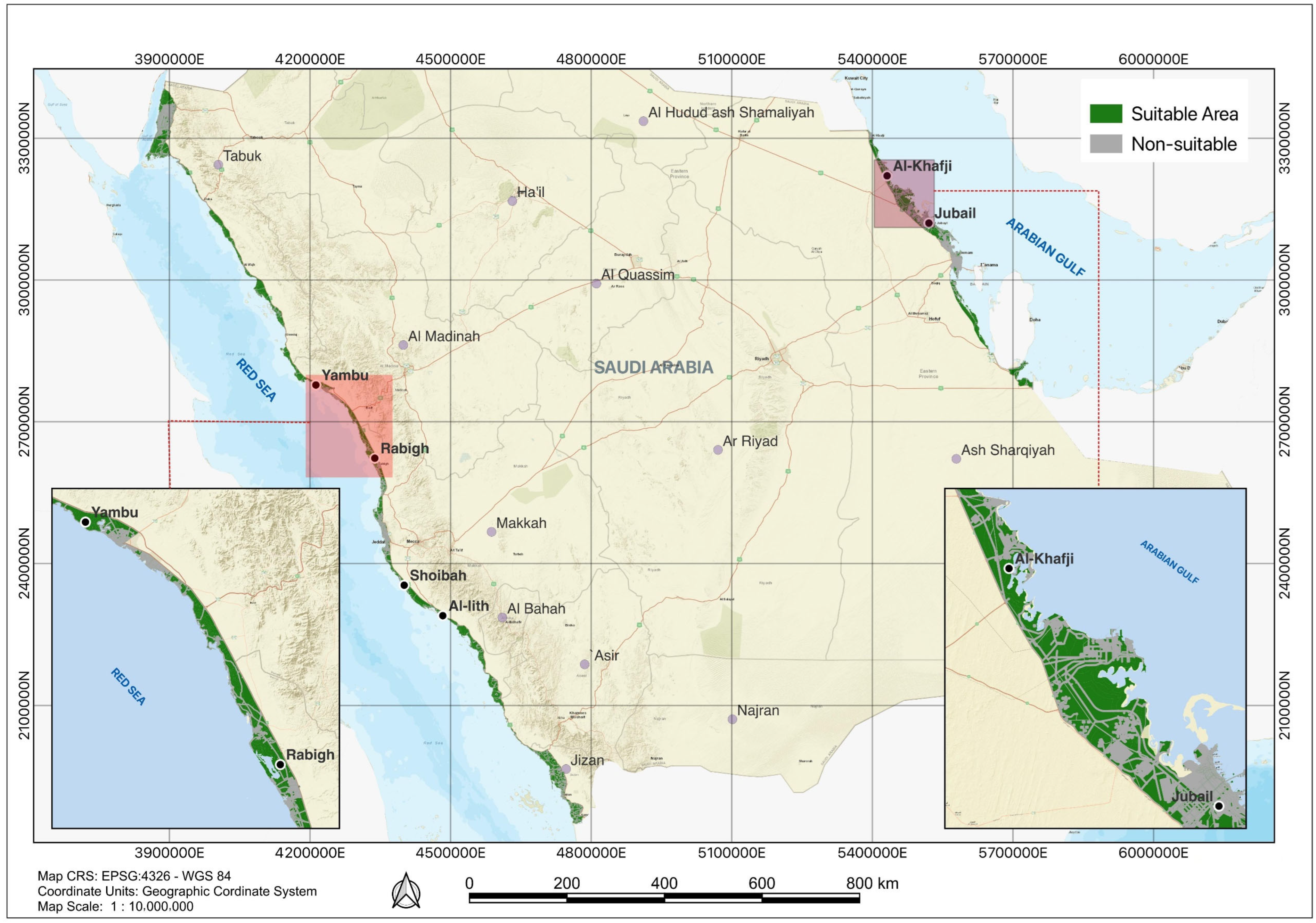
Figure 1. Area of interest with the compilation of restrictors.
Sustainability 17 10480 g001
Figure 2. The suitability map for microalgae cultivation in the Kingdom of Saudi Arabia.
Sustainability 17 10480 g002
Figure 3. The suitability of the area for the microalgae plant Petro Rabigh.
Sustainability 17 10480 g003
Figure 4. The suitability of the area for the microalgae plant Alkhomrah Wastewater Plant, Jeddah, KSA.
Sustainability 17 10480 g004
Figure 5. The suitability of the area for the microalgae plant Radwa Chicken Farm.
Sustainability 17 10480 g005
Table 1. Data Sources and Extraction Methods for Restrictive Factors in Microalgae Cultivation.
RestrictorData SourceExtraction Method
Wadi, Coastal LineAdministrative Map of Saudi Arabia 2023 by General Authority for Statistics, Saudi ArabiaManually extracted and recalibrated to improve accuracy.
Residence, Industries, Agricultural areasLand use Maps of Saudi Arabia 2023 by General Authority for Statistics, Saudi ArabiaDigitally extracted and verified against the latest industrial data using Google Earth Engine (GEE).
Digitally extracted using GIS software (ArcGIS PRO 3.3) with Landsat 8 satellite imagery as a base map.
Wind speed, TemperatureGlobal Wind Atlas 2023 by Technical University of Denmark (DTU)Digitally extracted using climate modeling tools.
Vegetation, Landsat 8 Satellite Imagery by United States Geological Survey (USGS) and NASAAnalyzed and extracted using remote sensing techniques.
Highway, Railway Transportation Network Map of Saudi Arabia 2023 by General Authority for Statistics, Saudi ArabiaManually extracted and recalibrated with Google Satellite 2024 to improve accuracy.
Electrical GridLandsat 8 Satellite Imagery 2023 by United States Geological Survey (USGS) and NASAManually extracted and recalibrated with Google Satellite 2024 to improve accuracy.
Slope, Bare RockLandsat 8 Satellite Imagery 2023 by United States Geological Survey (USGS) and NASA Digitally extracted and verified against the latest industrial data using Google Earth Engine (GEE).
Digitally extracted using GIS software with Landsat 8 satellite imagery as a base map.
Table 2. Sources, description, and weight for enablers and restrictors criteria.
Data SetDescriptionWeightage
Wadi/RiverPolyline shapefile that represents all grids with wadi are excluded.0 (inside wadi), 1 (outside wadi)
ResidencePolygon shapefile utilized to accurately delineate areas that maintain a minimum distance of 500 m from residential zones.0 (within), 1 (outside)
SlopePolygon shapefile are employed to identify areas with slopes exceeding 4%.0 (area with slope > 4%) and 1 (area with slope ≤ 4%)
RailwayPolylines shapefile utilized to accurately delineate areas within a 400-m distance from railway zones.0 (within), 1 (outside)
HighwayPolylines shapefile employed to accurately delineate areas within a 400-m distance from highways.0 (within), 1 (outside)
Electrical GridPolylines shapefile utilized to exclude areas along the electrical route within a 100-m radius.0 (within), 1 (outside)
Land use and rough land contourPolylines shapefile utilized to exclude all the footprint areas.0 (within), 1 (outside)
Industries (Powerplant sites, Desalination sites, Factories, Industries, Oil Mining)Polygons shapefile assigned high weights to regions exhibiting significant interdependencies or correlations with the industrial activities.Proximity (m)Weight
10005
20004
30003
40002
50001
The results of this area will be multiplied by factor (f) of 5.
Wastewater treatment plantPolygons shapefile assigned high weights to regions exhibiting significant water/wastewater treatment facility activities.Proximity (m)Weight
10005
20004
30003
40002
50001
The results of this area will be multiplied by factor (f) of 5.
Agricultural waste/wastewaterPolygons shapefile assigned high weights to regions exhibiting significant agricultural facilities or activities that possibly provide nutrients sources for the cultivation.Proximity (m)Weight
10005
20004
30003
40002
50001
The results of this area will be multiplied by factor (f) of 5.
Wind and Sandstormspolygon shapefile emphasizes lower sandstorm impacts as reflected in the weight or relative value assigned to the area in the overall calculationsAnn. wind speed (m/s)Weight
0–25
2–44
4–63
6–82
>81
The results of this area will be multiplied by factor (f) of 1.
Annual temperaturePolygons shapefile constructed to map annual temperature variations, considering that algae growth requires specific temperature conditions to optimize its growthAnn. temp (C°)Weight
<253
25–305
30–355
35–404
>403
The results of this area will be multiplied by factor (f) of 2.
Coastal linePolylines shapefile employed to establish the minimum distance boundary of areas from the coastline, extending up to 500 m from 1000 m distance.Proximity (m)Weight
10005
20004
30003
40002
50001
The results of this area will be multiplied by factor (f) of 3.
Table 3. Classification of suitability index based on the total score of the area for microalgae plant.
Total WeightageSuitabilitySuitability Index
50–55SuitableVery High
40–49High
30–39Medium
20–29Low
1–19Very Low
0Non-Suitable-
Table 4. Suitability index for microalgae cultivation in the Red Sea and Arabian Gulf Areas, Kingdom of Saudi Arabia.
CategoriesSuitability IndexArea (km2)Total (km2)
Non-SuitableNon-Suitable10,76310,763
SuitableVery low208814,008
Low1264
Medium4322
High4728
Very High1606
Disclaimer/Publisher’s Note: The statements, opinions and data contained in all publications are solely those of the individual author(s) and contributor(s) and not of MDPI and/or the editor(s). MDPI and/or the editor(s) disclaim responsibility for any injury to people or property resulting from any ideas, methods, instructions or products referred to in the content.