Settlement and Deformation Characteristics of Grouting-Filled Goaf Areas Using Integrated InSAR Technologies
Abstract
1. Introduction
- (1)
- An analysis method for the spatio-temporal distribution characteristics of surface deformation in grouting and filling of the goaf is proposed, which integrates various InSAR technologies, effectively addressing the model errors of each InSAR technology and enhancing monitoring accuracy.
- (2)
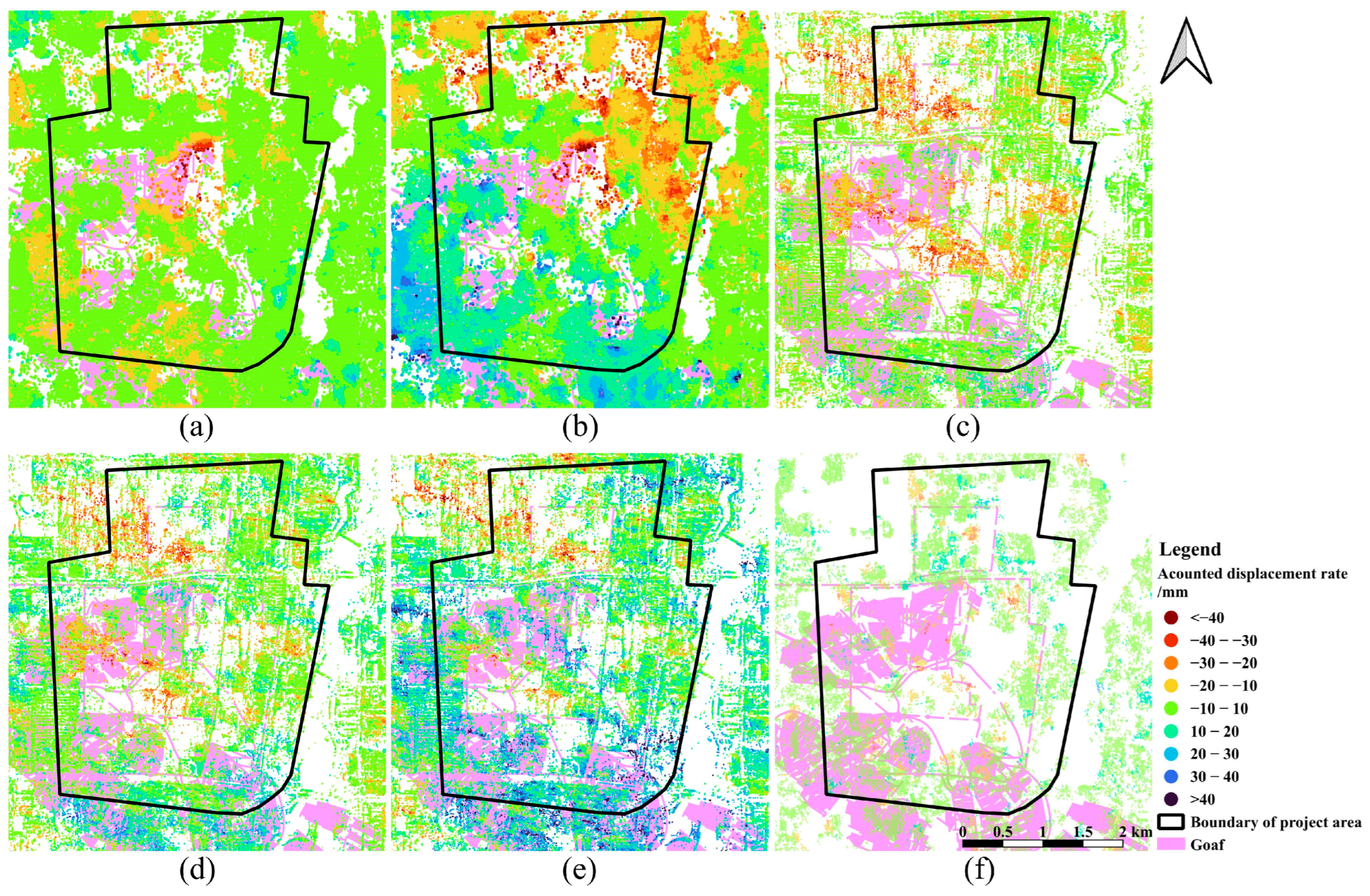
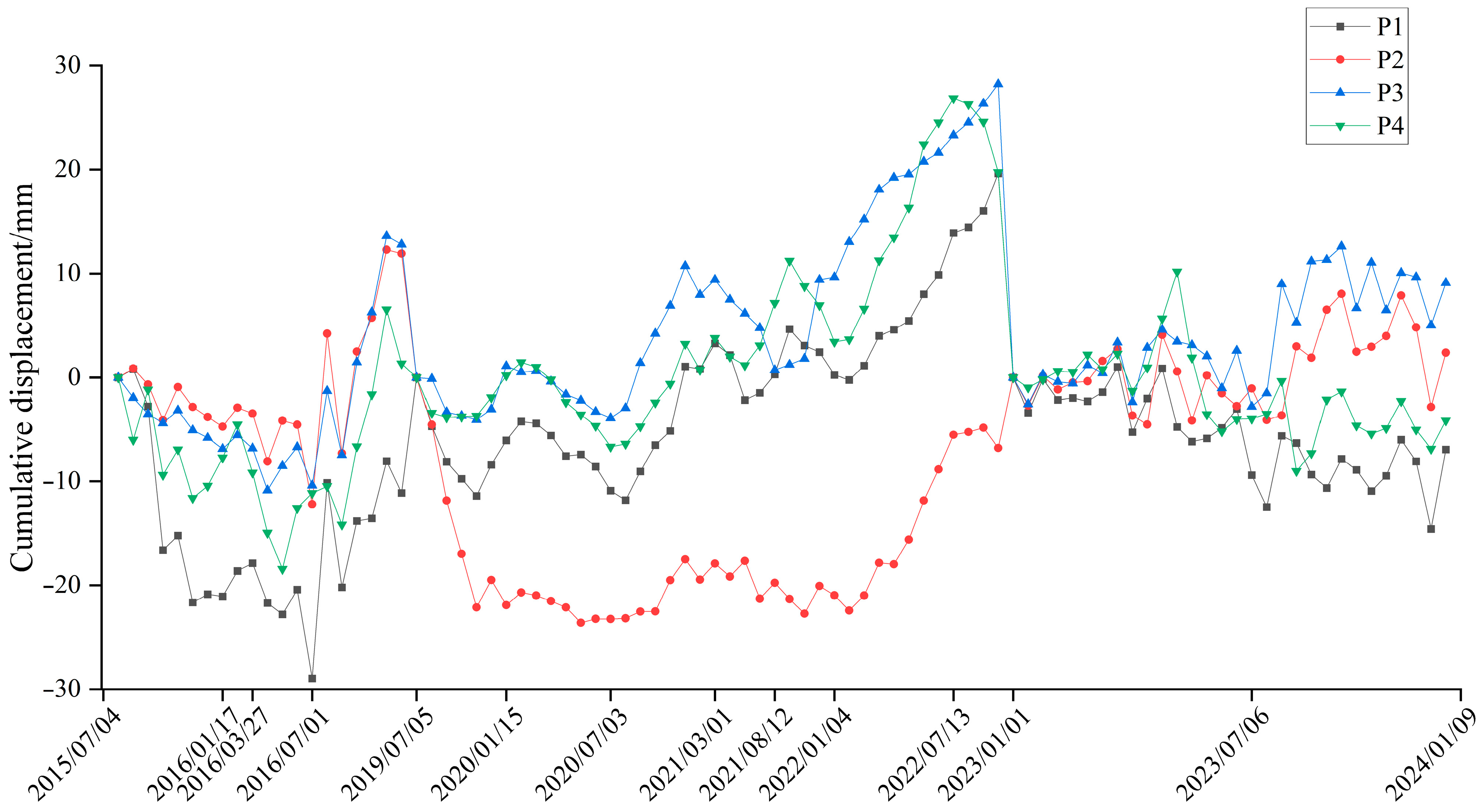
- Through the analysis of regional settlement rates, cumulative settlement values over time series, and typical coherent points, the distribution characteristics of surface deformation in the study area from before grouting, during grouting, and after grouting are obtained. This reveals the variation law of surface deformation in the study area, showing a transition from surface subsidence and residual deformation caused by mining before grouting to slow surface subsidence and uplift during grouting, and then to the stabilization of surface deformation after grouting. These results can provide effective technical support for mining activities and the management of the mining area.
2. Research Area and Data Sources
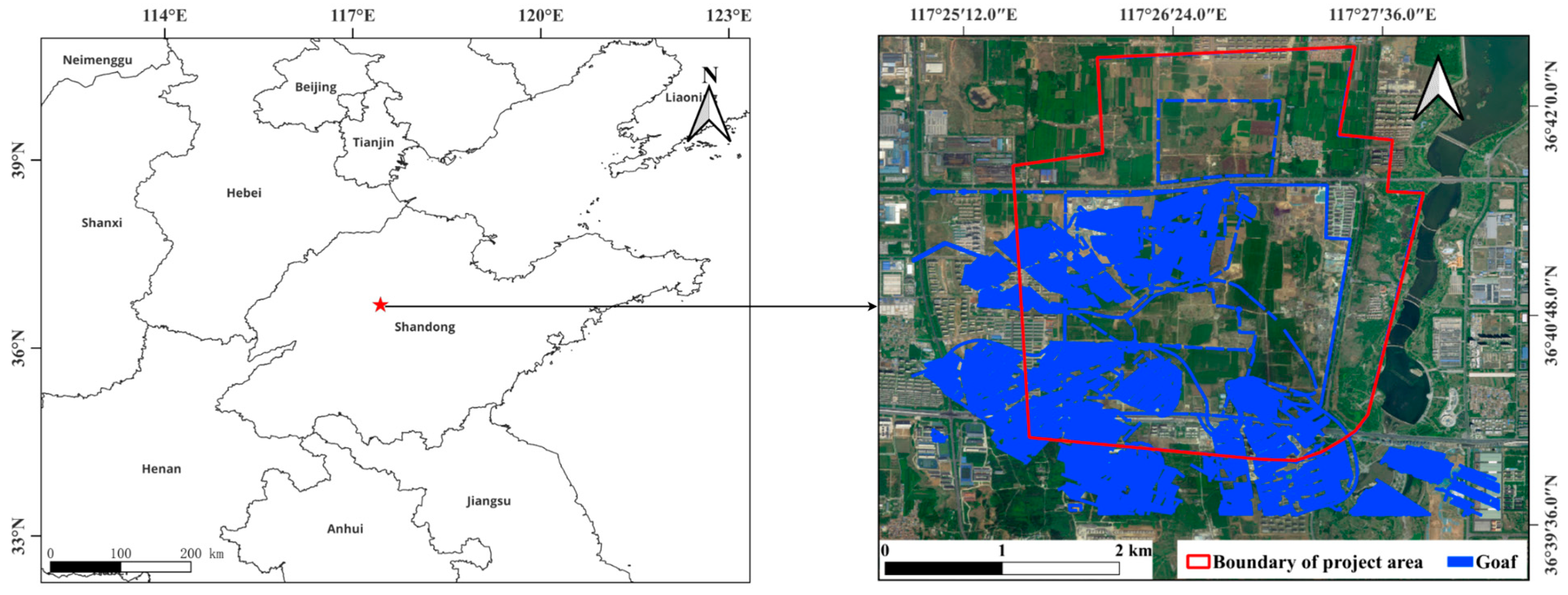
2.1. Overview of the Research Area
2.2. Data Sources
3. Data Processing Methods and Procedures
3.1. Data Processing Techniques
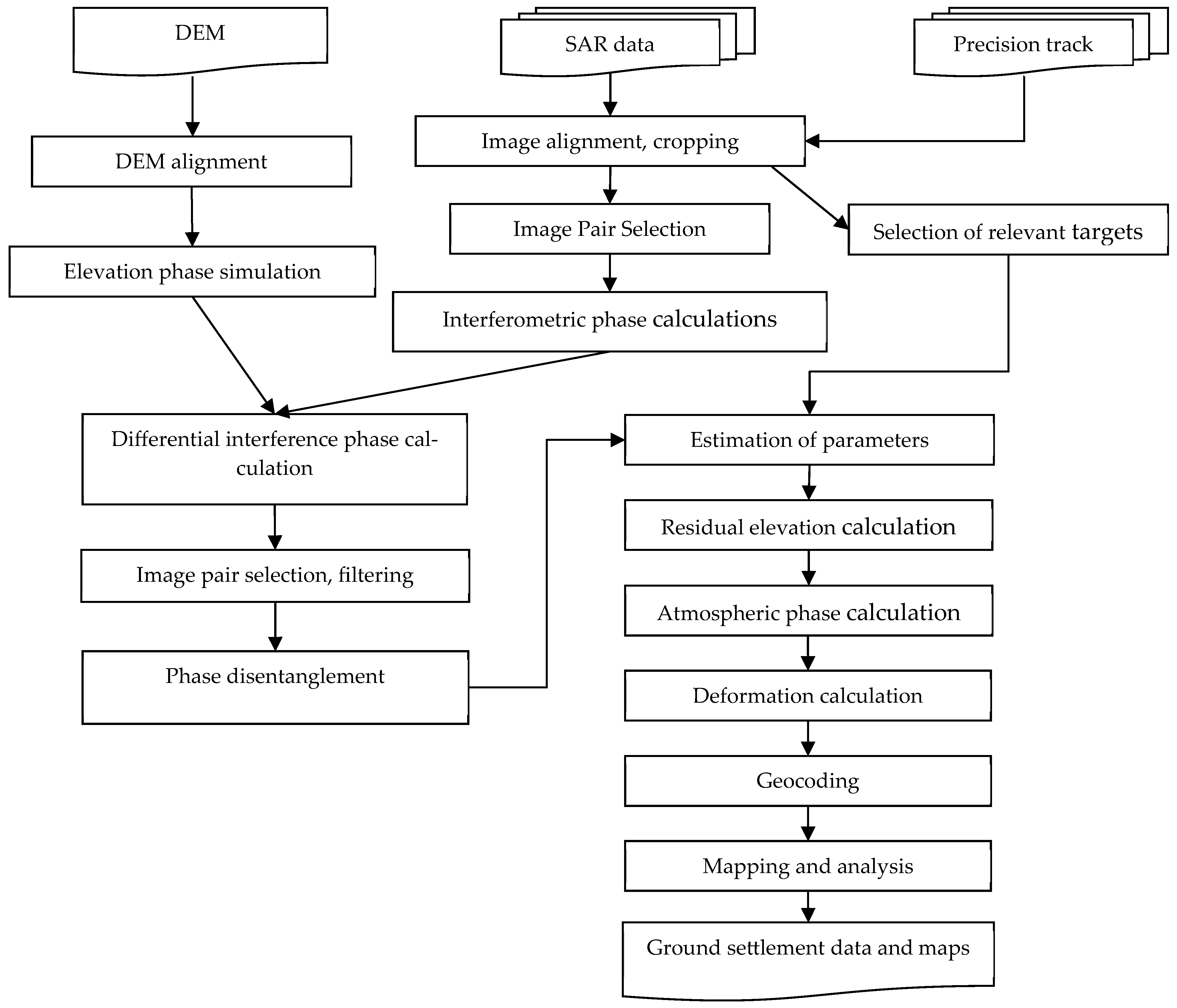
3.2. Data Processing Workflow
- Radar Data Registration
- Interference selection of image pairs and processing using D-InSAR technology
- Coherent Objective Temporal Analysis
4. Experimental Results and Analysis
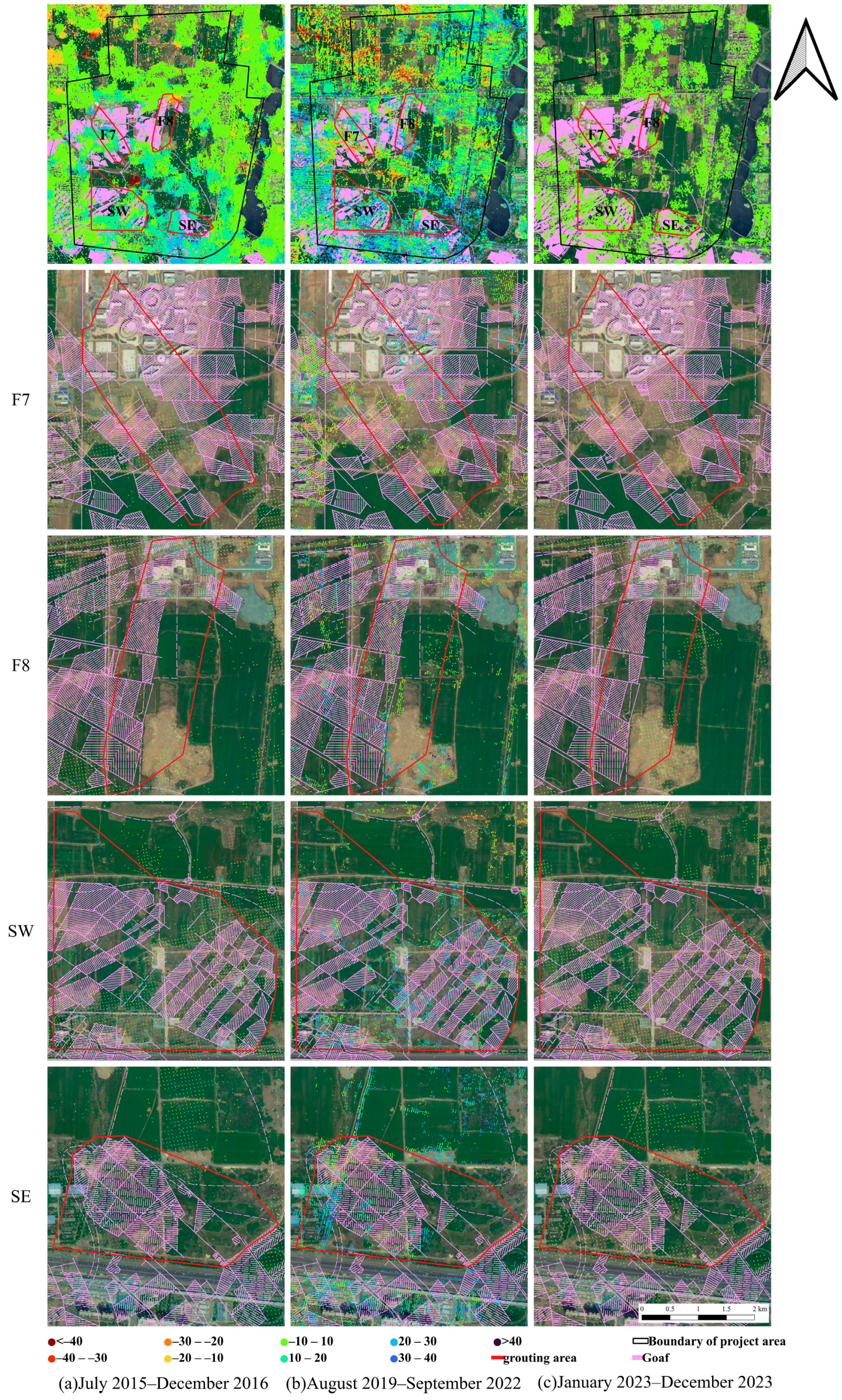
4.1. Analysis of Regional Settlement Rates and Cumulative Settlement Values over Time
4.2. Analysis of Typical Coherent Point Settlement Values
5. Discussion
5.1. Discussion on Experimental Results
5.2. Comparative Analysis
5.3. Limitations and Uncertainties
5.4. Implications for Mine Safety and Sustainable Practices
6. Conclusions
- (1)
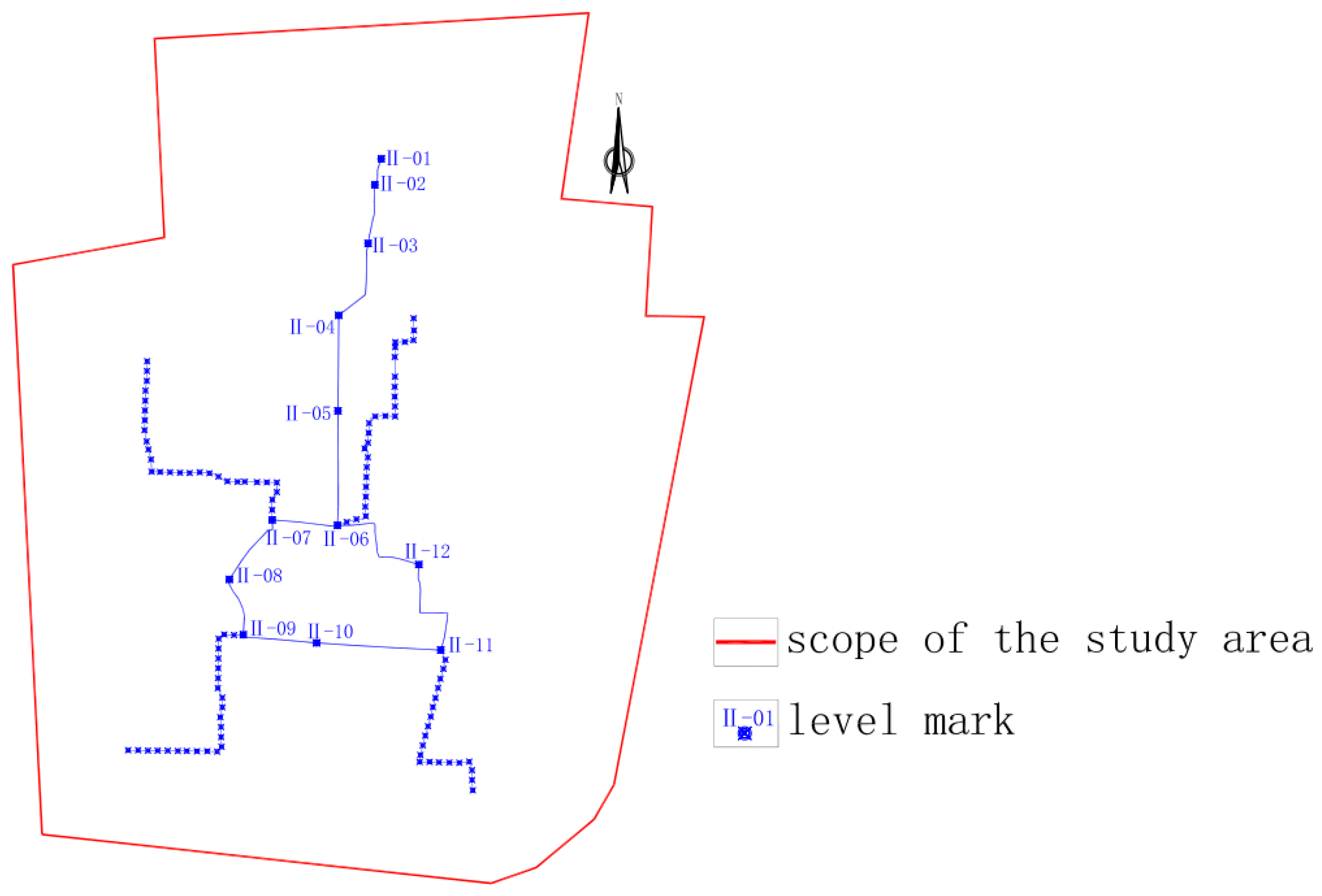
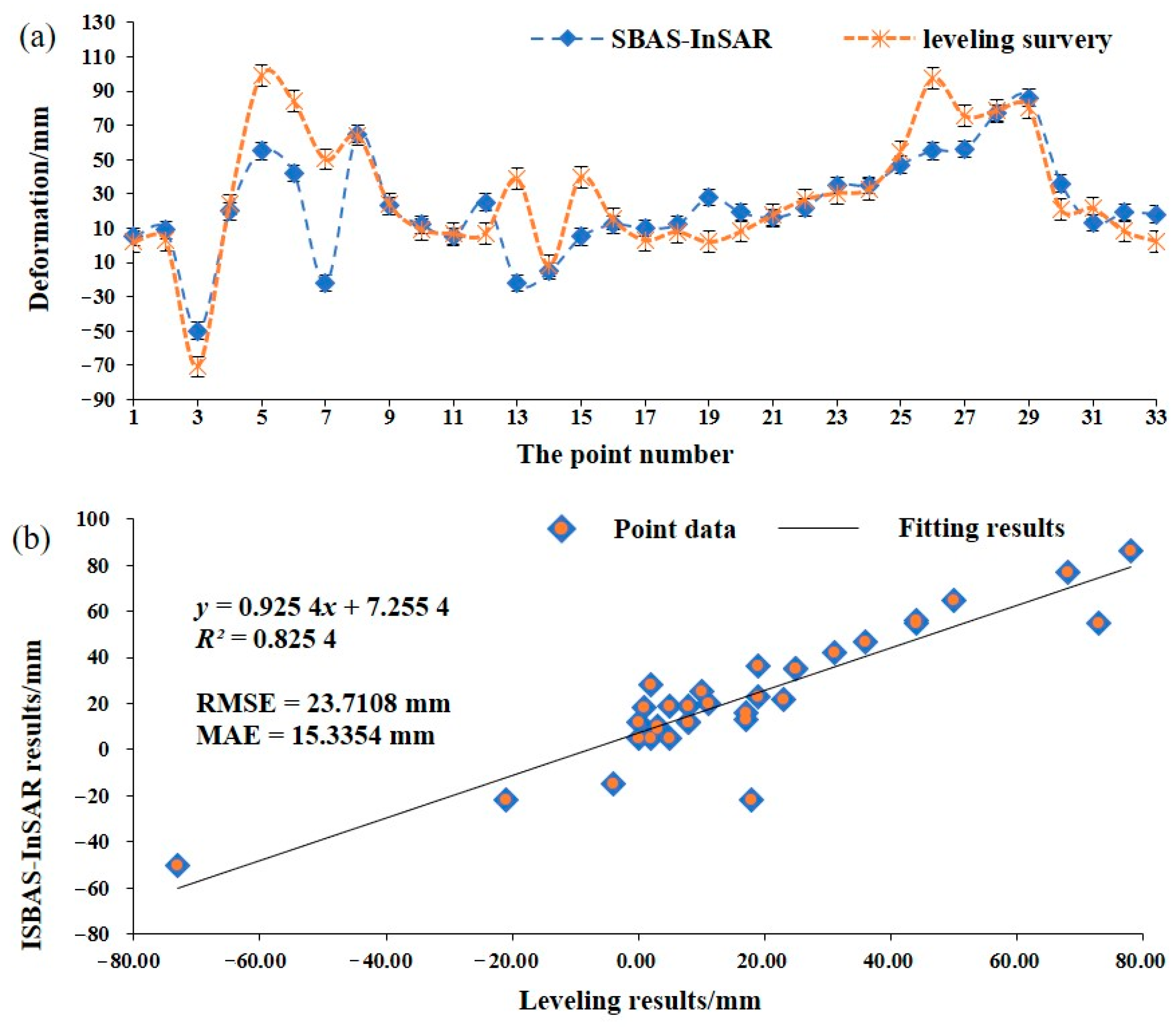
- An integrated approach to analyzing the spatio-temporal characteristics of surface deformation was developed by synthesizing multiple InSAR methodologies, including D-InSAR, PS-InSAR, and SBAS-InSAR. This method applies a strategy to select image pairs with optimal spatial and temporal baselines from SBAS images. Using D-InSAR as the foundation, an interferogram collection is generated, and stable coherent target points are identified through the PS method. The phase information of these coherent target points is resolved to derive surface subsidence rates and time series. The comparison with the leveling measurement data shows that the accuracy of this method meets the requirements and it is suitable for monitoring the residual deformation of the surface after grouting
- (2)
- Through an examination of regional subsidence rates, cumulative settlement values over time, and typical coherent points, the study outlines the distribution characteristics of surface deformation in the research area across the pre-grouting, grouting, and post-grouting stages. The findings show the progression of surface deformation patterns, indicating that prior to grouting, mining activities lead to surface subsidence and residual deformation. During grouting, the deformation gradually shifts to subsidence and uplift, and following grouting, the deformation stabilizes.
- (3)
- Prior to grouting (July 2015–December 2016), the study area exhibited peak deformation rates, with subsidence reaching 98 mm/a and uplift attaining 134 mm/a. During the grouting phase (August 2019–September 2022), these rates were substantially reduced, with maximum uplift and subsidence measured at 18.7 mm/a and −11.2 mm/a, respectively. The maximum uplift rate is 16.0 mm/a, and the maximum subsidence rate is −10.0 mm/a in the post-grouting stage (January 2023–December 2023). Overall, from the pre-grouting stage through the grouting and post-grouting stages, the surface deformation rates in the project area show a consistent declining trend.
Author Contributions
Funding
Institutional Review Board Statement
Informed Consent Statement
Data Availability Statement
Conflicts of Interest
References
- Statistical Bulletin on National Economic and Social Development of the People’s Republic of China, 2023. Available online: https://www.yicaiglobal.com/star50news/2024_02_296663307186254381071 (accessed on 4 November 2025).
- Zhang, H. Research and Application of the Distribution Patterns of Residual Voids in Old Mining Areas. Ph.D. Thesis, China University of Mining and Technology, Xuzhou, China, 2013. [Google Scholar]
- Ghulam, A.; Grzovic, M.; Maimaitijiang, M.; Sawut, M. InSAR monitoring of land subsidence for sustainable urban planning. In Remote Sensing for Sustainability; CRC Press: Boca Raton, FL, USA, 2016; pp. 61–65. [Google Scholar]
- Liang, Y. Research on Grouting Reinforcement in Old Mining Areas of Longwall Mining to Mitigate Residual Subsidence of Overburden. Master’s Thesis, Shandong University of Science and Technology, Qingdao, China, 2020. [Google Scholar]
- Xu, L.; Guo, H.; Zhu, N.; Qin, C. Study on residual deformation law of overlying rock strata and surface above old mined goaf under the building loading. Bull. Surv. Mapp. 2015, 5, 103–108. [Google Scholar]
- Castellazzi, P.; Garfias, J.; Martel, R.; Brouard, C.; Rivera, A. InSAR to support sustainable urbanization over compacting aquifers: The case of Toluca Valley, Mexico. Int. J. Appl. Earth Obs. Geoinf. 2017, 63, 33–44. [Google Scholar] [CrossRef]
- Liu, M.; Li, W.; Ye, Y.; Li, X.; Wei, W.; Xin, C. Identification and Assessment of Geological Hazards in Highly Vegetated Areas Based on Multi-Source Radar Remote Sensing Data: Supporting Sustainable Disaster Risk Management. Sustainability 2025, 17, 8070. [Google Scholar] [CrossRef]
- Zhou, D.; Zuo, X.; Zhao, Z.; Xi, W.; Ge, C. Prediction of urban land subsidence by SBAS-InSAR and improved BP neural network. Geol. Bull. China 2023, 42, 1774–1783. [Google Scholar]
- Wang, F.; Tao, Q.; Liu, G.; Chen, Y.; Han, Y.; Guo, Z.; Liu, X. Monitoring of surface deformation in mining area integrating SBAS InSAR and logistic function. Environ. Monit. Assess. 2023, 195, 1493. [Google Scholar] [CrossRef]
- Wang, Z.; Zhao, Y.; Wang, P.; Wang, X.; Jiang, A.; Zhang, G.; Li, W.; Liu, J. Refined subsidence monitoring and dynamic prediction in narrow and long mining areas based on InSAR and probabilistic integral method. Sci. Rep. 2024, 14, 28009. [Google Scholar] [CrossRef]
- Zhu, M.; Yu, X.; Tan, H.; Yuan, J. Integrated high-precision monitoring method for surface subsidence in mining areas using D-InSAR, SBAS, and UAV technologies. Sci. Rep. 2024, 14, 12445. [Google Scholar] [CrossRef]
- Chen, Y.; Yu, S.; Tao, Q.; Liu, G.; Wang, L.; Wang, F. Accuracy verification and correction of D-InSAR and SBAS-InSAR in monitoring mining surface subsidence. Remote Sens. 2021, 13, 4365. [Google Scholar] [CrossRef]
- Wang, Z.; Dai, H.; Yan, Y.; Liu, J.; Ren, J. Combination of InSAR with a depression angle model for 3D deformation monitoring in mining areas. Remote Sens. 2023, 15, 1834. [Google Scholar] [CrossRef]
- He, Q.; Wei, L.; Xiao, Y. Analysis of spatial-temporal distribution characteristics and influencing factors of land subsidence in Bozhou City, Anhui Province based on SBAS-InSAR technology. Chin. J. Geol. Hazard Control 2023, 34, 81–90. [Google Scholar]
- Liu, X.; Tao, Q.; Niu, C.; Li, B.; Zhang, Y.; Ren, Y. Comparative analysis and veriffcation of D-InSAR and SBAS-InSAR in mining subsidence monitoring. Prog. Geophys. 2022, 37, 1825–1833. [Google Scholar]
- Wang, L.; Zhang, X.N.; Chi, S.S.; Zha, J.F. Parameter inversion model for mining subsidence prediction based on fusion of InSAR and GA. Geomat. Inf. Sci. Wuhan Univ. 2018, 43, 1635–1641. [Google Scholar]
- Colomina, I.; Molina, P. Unmanned aerial systems for photogrammetry and remote sensing: A review. ISPRS J. Photogramm. Remote Sens. 2014, 92, 79–97. [Google Scholar] [CrossRef]
- Zhao, J.; Yang, X.; Zhang, Z.; Niu, Y.; Zhao, Z. Mine subsidence monitoring integrating DS-InSAR with UAV photogrammetry products: Case studies on Hebei and Inner Mongolia. Remote Sens. 2023, 15, 4998. [Google Scholar] [CrossRef]
- Long, N.Q.; Goyal, R.; Bui, L.K.; Cuong, C.X.; Canh, L.V.; Minh, N.Q.; Bui, X.N. Optimal choice of the number of ground control points for developing precise DSM using light-weight UAV in small and medium-sized open-pit mine. Arch. Min. Sci. 2021, 66, 369–384. [Google Scholar]
- Du, S.; Wang, Y.; Zheng, M.; Zhou, D.; Xia, Y. Goaf locating based on InSAR and probability integration method. Remote Sens. 2019, 11, 812. [Google Scholar] [CrossRef]
- Zhang, L.; Gao, P.; Gan, Z.; Wu, W.; Sun, Y.; Zhu, C.; Long, S.; Liu, M.; Peng, H. Surface subsidence monitoring of mining areas in hunan province based on Sentinel-1A and DS-InSAR. Sensors 2023, 23, 8146. [Google Scholar] [CrossRef]
- Fan, H.; Li, T.; Gao, Y.; Deng, K.; Wu, H. Characteristics inversion of underground goaf based on InSAR techniques and PIM. Int. J. Appl. Earth Obs. Geoinf. 2021, 103, 102526. [Google Scholar] [CrossRef]
- Huang, X.; Li, X.; Li, H.; Duan, S.; Yang, Y.; Du, H.; Xiao, W. Study on the Movement of Overlying Rock Strata and Surface Movement in Mine Goaf under Different Treatment Methods Based on PS-InSAR Technology. Appl. Sci. 2024, 14, 2651. [Google Scholar] [CrossRef]
- Xia, Y.; Xia, F.; Hui, Z.; Li, H.; Wan, R.; Ai, J. Combined ps-insar technology and high-resolution optical remote sensing for identifying illegal underground mining in the suburb of yangquan city, shanxi province, China. Remote Sens. 2023, 15, 3565. [Google Scholar] [CrossRef]
- Lee, S.J.; Yun, H.S.; Kwak, S.W. Sustainable Risk Mapping of High-Speed Rail Networks Through PS-InSAR and Geospatial Analysis. Sustainability 2025, 17, 7064. [Google Scholar] [CrossRef]
- Sajjad, M.M.; Wang, J.; Afzal, Z.; Hussain, S.; Siddique, A.; Khan, R.; Ali, M.; Iqbal, J. Assessing the impacts of groundwater depletion and aquifer degradation on land subsidence in Lahore, Pakistan: A PS-InSAR approach for sustainable urban development. Remote Sens. 2023, 15, 5418. [Google Scholar] [CrossRef]
- Lu, X.; Li, X.; Zhang, Q.; Huang, H. Surface subsidence monitoring of old goaf based on the PS-InSAR technology. China Min. Mag. 2019, 28, 104–110. [Google Scholar]
- Chen, Y.; Dong, X.; Qi, Y.; Huang, P.; Sun, W.; Xu, W.; Tan, W.; Li, X.; Liu, X. Integration of DInSAR-PS-stacking and SBAS-PS-InSAR methods to monitor mining-related surface subsidence. Remote Sens. 2023, 15, 2691. [Google Scholar] [CrossRef]
- Wang, R.; Fei, M.; Liang, S.; Xue, H.; Luo, X. Monitoring of surface deformation characteristics in Xi’an based on SBAS-InSAR technology. Bull. Surv. Mapp. 2023, 1, 173–178. [Google Scholar]
- Zhang, F.; Chang, L.; Xun, Z. Surface deformation monitoring in Yanghuopan Mining Area based on SBAS-InSAR technology. China Min. Mag. 2024, 33, 152–159. [Google Scholar]
- Liang, S.; Hu, H. Analysis of residual deformation in goaf based on SBAS-InSAR technology. China Min. Mag. 2022, 31, 70–78. [Google Scholar]
- Yang, L.; Xue, D.; Wang, H.; Fu, L.; Zhang, T. Time series InSAR surface deformation monitoring in Wulonggou Mining Area. China Min. Mag. 2021, 30, 107–112. [Google Scholar]
- Zhang, J.; Cui, L.; Liu, Z.; Wang, X.; Lin, L.; Xu, F. Large-area surface deformation monitoring using Sentinel-1 SAR data and SBAS technology. Bull. Surv. Mapp. 2020, 7, 125–129. [Google Scholar]
- Ma, X.; Wu, P. Polarimetric radar image despeckling by iteratively refined nonlocal means. Acta Geod. Cartogr. Sin. 2019, 48, 1038–1045. [Google Scholar]
- Liu, Z.; Lu, C.; Zhang, S.; Li, M.; He, Z. Surface subsidence monitoring in mining area based on multi-threshold target extraction time series InSAR. China Min. Mag. 2022, 31, 79–85. [Google Scholar]
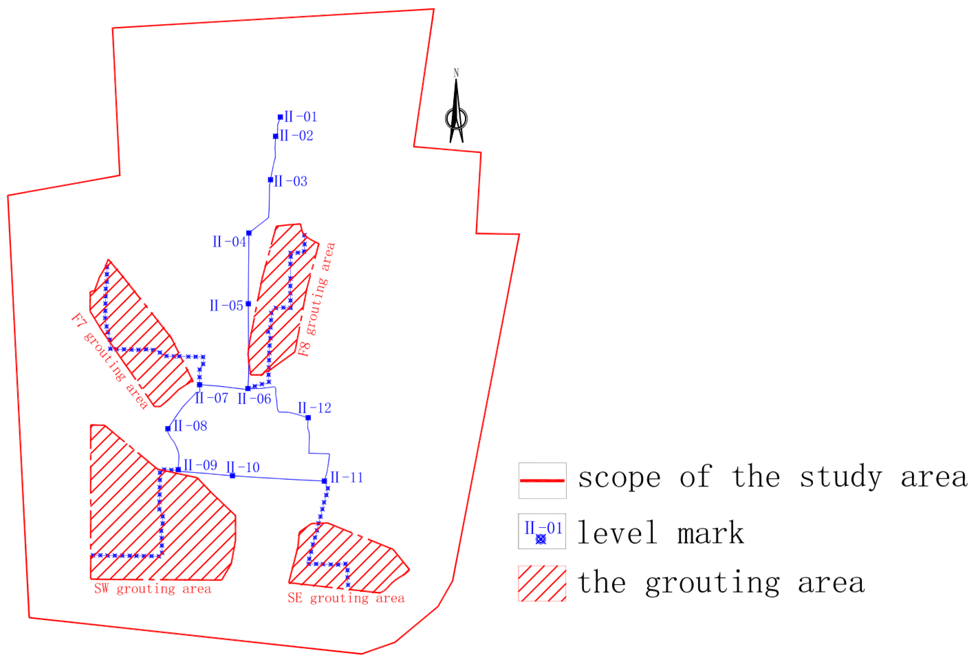

| Grouting Area | Main Coal Seam | Number of Grouting Holes | Grout Amount (M3) |
|---|---|---|---|
| F7 | No. 3 coal seam | 127 | 78,908 |
| F8 | No. 1 and 3 coal seams | 134 | 88,830 |
| SW | No. 3 and 9 coal seams | 220 | 613,468 |
| SE | No. 1 and 3 coal seams | 47 | 93,893 |
| Parameter | Value |
|---|---|
| Satellite type | RadarSAT-2 |
| Waveband | C |
| Imaging mode | XF |
| Spatial resolution | 5 m |
| Lift/descent mode | de-orbiting |
| Polarization mode | VV |
| Number of images | 39 |
| Data level | SLC |
| Monitoring start time | August 2019 |
| Monitoring termination time | September 2022 |
| InSAR processing algorithm | SBAS, D-InSAR, PS-InSAR |
| Number | Date | Number | Date | Number | Date |
|---|---|---|---|---|---|
| 1 | 2 August 2019 | 14 | 27 July 2020 | 27 | 13 December 2021 |
| 2 | 26 August 2019 | 15 | 13 September 2020 | 28 | 6 January 2022 |
| 3 | 19 September 2019 | 16 | 7 October 2020 | 29 | 30 January 2022 |
| 4 | 13 October 2019 | 17 | 31 October 2020 | 30 | 23 February 2022 |
| 5 | 6 November 2019 | 18 | 24 November 2020 | 31 | 19 March 2022 |
| 6 | 17 January 2020 | 19 | 18 December 2020 | 32 | 12 April 2022 |
| 7 | 10 February 2020 | 20 | 28 February 2021 | 33 | 6 May 2022 |
| 8 | 5 March 2020 | 21 | 24 March 2021 | 34 | 30 May 2022 |
| 9 | 29 March 2020 | 22 | 17 April 2021 | 35 | 23 June 2022 |
| 10 | 22 April 2020 | 23 | 4 June 2021 | 36 | 17 July 2022 |
| 11 | 16 May 2020 | 24 | 15 August 2021 | 37 | 10 August 2022 |
| 12 | 9 June 2020 | 25 | 8 September 2021 | 38 | 3 September 2022 |
| 13 | 3 July 2020 | 26 | 2 October 2021 | 39 | 27 September 2022 |
Disclaimer/Publisher’s Note: The statements, opinions and data contained in all publications are solely those of the individual author(s) and contributor(s) and not of MDPI and/or the editor(s). MDPI and/or the editor(s) disclaim responsibility for any injury to people or property resulting from any ideas, methods, instructions or products referred to in the content. |
© 2025 by the authors. Licensee MDPI, Basel, Switzerland. This article is an open access article distributed under the terms and conditions of the Creative Commons Attribution (CC BY) license (https://creativecommons.org/licenses/by/4.0/).
Share and Cite
Li, X.; Dai, H.; Li, F.; Zhang, H.; Fang, J. Settlement and Deformation Characteristics of Grouting-Filled Goaf Areas Using Integrated InSAR Technologies. Sustainability 2025, 17, 10015. https://doi.org/10.3390/su172210015
Li X, Dai H, Li F, Zhang H, Fang J. Settlement and Deformation Characteristics of Grouting-Filled Goaf Areas Using Integrated InSAR Technologies. Sustainability. 2025; 17(22):10015. https://doi.org/10.3390/su172210015
Chicago/Turabian StyleLi, Xingli, Huayang Dai, Fengming Li, Haolei Zhang, and Jun Fang. 2025. "Settlement and Deformation Characteristics of Grouting-Filled Goaf Areas Using Integrated InSAR Technologies" Sustainability 17, no. 22: 10015. https://doi.org/10.3390/su172210015
APA StyleLi, X., Dai, H., Li, F., Zhang, H., & Fang, J. (2025). Settlement and Deformation Characteristics of Grouting-Filled Goaf Areas Using Integrated InSAR Technologies. Sustainability, 17(22), 10015. https://doi.org/10.3390/su172210015


