Abstract
Floods are among the most frequent and damaging natural hazards in the Mekong River Basin, where the interplay of monsoon-driven climate variability, complex topography, and rapid socio-economic change creates high exposure and vulnerability. This study presents a comprehensive assessment of flood disaster patterns, loss distribution, and regional disparities across five countries in the Lower Mekong Basin—Cambodia, Laos, Myanmar, Thailand, and Vietnam. Using multivariate spatiotemporal analysis based on EM-DAT, MRC, and national government datasets, the study quantifies flood frequency, casualties, and affected population to reveal cross-country differences in disaster impact and timing. Results show that while Vietnam and Thailand experience high flood frequency and storm-induced events, Laos and Cambodia face riverine flooding under constrained economic and infrastructural conditions. The findings highlight a basin-wide increase in flood frequency over recent decades, driven by climate change, land use transitions, and uneven development. The analysis identifies critical gaps in adaptive governance, particularly the need for dynamic policy frameworks that can adjust to spatial disparities in flood typologies (e.g., Vietnam’s storm floods vs. Cambodia’s riverine floods) and improve transboundary coordination of reservoir operations. Despite the region’s extensive reservoir capacity, most infrastructure prioritizes hydropower over flood mitigation. The study evaluates the role of regional cooperation frameworks such as the Lancang–Mekong Cooperation (LMC), demonstrating how strengthened institutional flexibility and knowledge-sharing mechanisms could enhance progress toward Sustainable Development Goals (SDGs) related to water governance (SDG 6), resilient infrastructure (SDG 9), and disaster risk reduction (SDG 11). By constructing the first integrated national-level flood disaster database for the basin and conducting comparative analysis across countries, this research provides empirical evidence to support differentiated yet coordinated flood risk governance strategies at both national and transboundary levels.
1. Introduction
Flood disasters have emerged as one of the most significant environmental risks globally, exacerbated by climate change and rapid socio-economic transformation. Flooding poses severe threats to human lives, infrastructure, agricultural production, and ecosystem health, particularly in vulnerable transboundary river basins. However, despite the growing risks, there is still a lack of comprehensive frameworks that guide systematic analysis of spatiotemporal dynamics, risk mechanisms, and adaptive governance of flood disasters in large-scale, multi-country contexts. A critical review of the existing literature reveals significant gaps: many studies focus on single events or localized areas, lacking a basin-scale, transboundary perspective. Furthermore, these studies often fail to integrate multi-source datasets, long-term temporal dimensions, or cross-country comparability, hindering a comprehensive understanding of regional flood risk [1,2,3,4]. The Mekong River is one of the world’s major international rivers, ranking 10th in length and 11th in annual runoff [5,6]. The Lower Mekong Basin (LMB), which spans five countries—Laos, Myanmar, Thailand, Cambodia, and Vietnam—covers an area of approximately 600,000 km2. The region is home to critical ecological assets such as Cambodia’s Tonle Sap Lake and Vietnam’s Mekong Delta, both of which play central roles in hydrological regulation and biodiversity conservation. The basin experiences a tropical monsoon climate, with annual precipitation ranging from 1200 to 3000 mm, of which over 80% occurs during the rainy season (May–October), resulting in frequent flooding. In contrast, the dry season (November–April) faces recurring drought conditions [7,8,9].
The Mekong Basin is home to approximately 70 million people, with a large proportion concentrated in the densely populated plains and delta regions, particularly in Cambodia and Vietnam. Agriculture, particularly rice farming and fisheries, is the main livelihood for these populations. However, the frequency and severity of flooding in the region have significantly increased in recent decades due to climate change, urbanization, and upstream hydrological modifications [8,10]. Between 1980 and 2020, the LMB accounted for over 80% of Southeast Asia’s flood-related fatalities and economic losses, highlighting the region’s extreme vulnerability to floods [9,11]. Despite this, few studies have conducted comprehensive, long-term, transboundary assessments of flood risks in the Mekong River Basin.
This study aims to fill these gaps by establishing a harmonized dataset of flood disaster losses across the Lower Mekong Basin over the past six decades. By integrating international databases, national reports, and field surveys, we employ a multi-source fusion approach to analyze (1) the spatial and temporal dynamics of flood events, (2) the socio-environmental mechanisms driving flood losses, and (3) the implications for adaptive governance.
The ultimate goal is to provide empirical evidence for flood risk management at the basin scale, supporting regionally coordinated disaster governance and adaptive policy formulation. This research also aligns with global Sustainable Development Goals (SDGs), particularly Goal 11: Sustainable Cities and Communities and Goal 13: Climate Action, by contributing to the development of climate-resilient flood governance strategies that can be applied both regionally and globally.
Furthermore, this study bridges environmental science with disaster risk governance and regional planning disciplines, fostering an integrated approach to flood resilience that is critical for sustainable development in the Mekong River Basin and beyond.
2. Materials and Methods
2.1. Data Sources
This study integrates multi-source disaster and environmental data from international organizations and regional institutions to assess flood disasters across the Lower Mekong River Basin. The primary data sources used in this analysis include:
EM-DAT (Emergency Events Database) from the Centre for Research on the Epidemiology of Disasters (CRED) [12], which provides consistent, long-term records of disaster events from 1962 onwards. This dataset includes detailed information on flood occurrences, fatalities, affected populations, and estimated economic losses. EM-DAT has been widely used for global disaster risk assessments and is considered a reliable source for flood-related data in the region.
ADRC Disaster Database, maintained by the Asian Disaster Reduction Center (ADRC) [13]. This database offers event-level data specifically focused on Asian countries, emphasizing local impacts and responses. The ADRC database is particularly valuable for understanding region-specific disaster patterns and the effectiveness of mitigation efforts.
ReliefWeb, managed by the United Nations Office for the Coordination of Humanitarian Affairs (OCHA) [14], provides real-time humanitarian information and disaster response data. This platform is essential for monitoring the immediate aftermath of flood events, including emergency relief and humanitarian efforts across the Mekong Basin.
Mekong River Commission (MRC) datasets, which include annual flood reports, hydrological bulletins [15,16,17,18,19,20,21], and basin planning documents [22,23,24,25]. These high-resolution datasets provide authoritative data on flood events and hydrological conditions specific to the Mekong countries. The MRC datasets are integral for understanding long-term trends in water management and flood risk in the region.
National-level data from the disaster management departments and National Committees of Cambodia, Laos, Thailand, Vietnam, and Myanmar. These sources offer important insights into local disaster management practices and flood mitigation strategies, reflecting the policy responses at the national level.
Additionally, satellite imagery and topographic data, such as 10 m resolution terrain models from Google Earth and Landsat imagery, were used for hydrological interpretation and spatial mapping. These remote sensing tools were crucial for generating accurate flood models and mapping the flood-prone areas. The data were validated through cross-referencing among the sources listed above, supplemented by field surveys, remote sensing interpretation conducted in 2018. This multi-faceted validation approach enhances the reliability of the data and ensures comprehensive flood risk analysis.
2.2. Analytical Methods
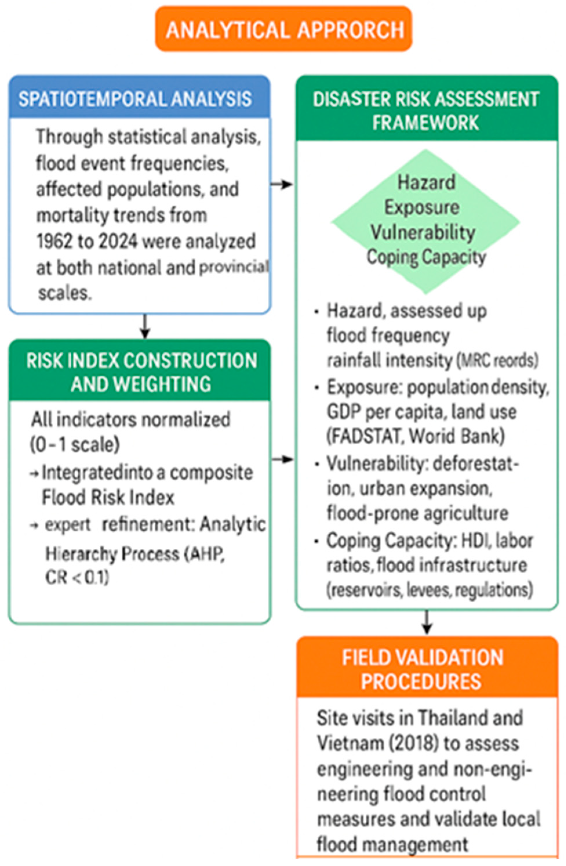
Spatiotemporal Analysis: Through statistical analysis, we mapped flood event frequencies, affected populations, and mortality trends from 1962 to 2024 at both national and provincial scales. The spatial frequency map was created by aggregating flood events based on national administrative units. Flood occurrences were mapped by digitizing historical data from the EM-DAT and ADRC databases into vector point data. These points were then overlaid onto national boundaries, and the occurrence of events was counted within each administrative unit.
Disaster Risk Assessment Framework: We adopted the widely applied four-component risk model recognized in disaster risk literature [26,27]:
- (i)
- Hazard: characterized by flood frequency and rainfall intensity (maximum 1-day and 5-day precipitation events derived from MRC hydrological records [15,16,17,18,19,20,21]).
- (ii)
- Exposure: measured via population density, GDP per capita, and land use classifications (agricultural and urban land proportions derived from FAOSTAT [28] and World Bank data [29].
- (iii)
- Vulnerability: evaluated through land-cover changes (deforestation trends), urban expansion dynamics, and dependency on flood-prone agricultural sectors, using FAOSTAT and MRC data [15,30].
- (iv)
- Coping Capacity: assessed using HDI, youth labor ratios (ages 15–64), and flood infrastructure metrics (reservoir storage per capita, levee density, and regulatory measures from ADB [31], UNDP [32], and MRC annual reports [15,16,17,18,19,20,21,22,23,24,25,30]).
Risk Index Construction and Weighting Process: All risk-related variables were normalized to a 0–1 scale and integrated into a composite Flood Risk Index using a weighted summation approach [26]. Weight assignments were guided by a comprehensive literature review (including established methodologies from INFORM Global Risk Index [33] and GloFAS—Global Flood Awareness System [34]) and further refined through expert judgment using the Analytic Hierarchy Process [35]).
The weighting process involved:
Initial objective weighting derived via the entropy weight method (EWM), which measures variable variance and thus reflects relative importance objectively.
Expert weights were refined through the Analytic Hierarchy Process (AHP), involving 10 specialists from leading Chinese institutions, all with extensive experience in Mekong flood risk governance. Expert scoring consistency was verified (CR < 0.1). Final indicator weights (examples): Hazard (0.30), Exposure (0.25), Vulnerability (0.25), Coping Capacity (0.20).
Field Validation Procedures: The analytical approach for this study is structured in Figure 1, which integrates spatiotemporal analysis, risk assessment, and field validation. Site visits were conducted in Thailand and Vietnam in 2018 to assess both engineering and non-engineering flood control measures in place. These visits aimed to validate the effectiveness of local flood management strategies and to provide ground-truth verification for flood risk assessments.
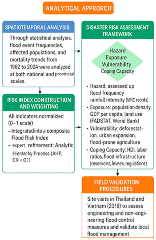
Figure 1.
Analytical Framework of Flood Disaster Assessment in the Mekong River Basin.
During the field visits, the following activities were carried out:
Inspection of Engineering Measures: Key flood control infrastructure, such as dams, levees, flood barriers, and drainage systems, were visited to assess their design, maintenance, and functionality in mitigating flood risks. Local engineers and government officials provided insights into the operational status and challenges faced by these infrastructures.
Evaluation of Non-Engineering Measures: Non-structural flood risk management practices, including early warning systems, flood zoning, land use regulations, and community-based response strategies, were reviewed.
In this study, “high-resolution data” specifically refers to spatial resolution, including 10 m resolution Digital Elevation Models (DEM) and Landsat satellite imagery. These data sources support fine-scale flood inundation analysis and hydrological modeling across diverse topographic and land use settings.
3. Results
3.1. Spatiotemporal Trends of Flood Disasters (1962–2024)
This analysis aims to assess the long-term trends in flood occurrence and their impacts across the Mekong River Basin, providing a foundation for understanding the evolving risk dynamics and contributing to flood risk management efforts in the region. To examine the temporal dynamics of flood disasters in the Mekong River Basin, this study analyzed three representative indicators from 1962 to 2024: the number of flood events, flood-related fatalities, and affected population.
In this analysis, “disasters” are specifically defined as flood events recorded in the EM-DAT and ADRC databases, with each event meeting at least one of the following criteria: at least ten fatalities, at least 100 people affected, declaration of a state of emergency, or international assistance requested.
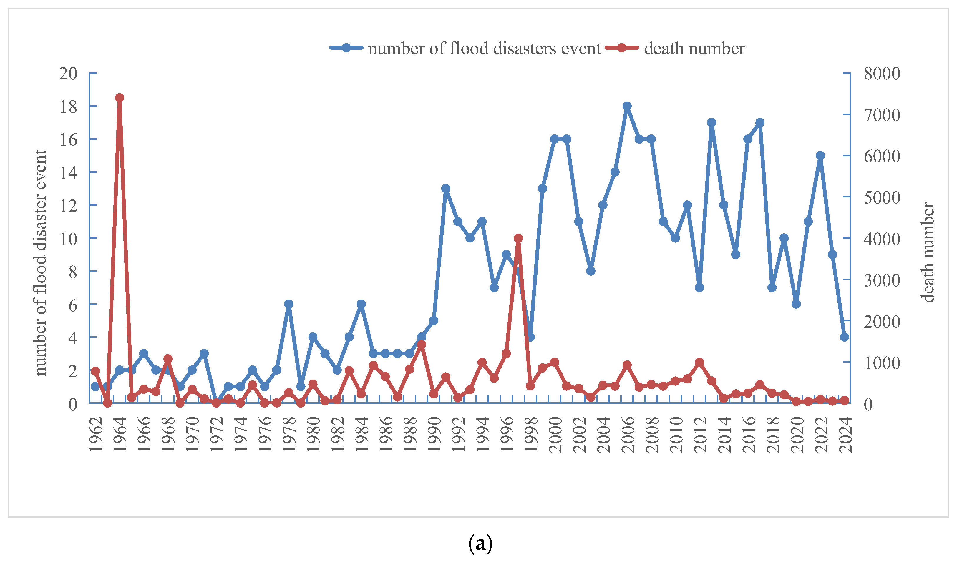
The analysis indicates a significant upward trend in flood frequency since 1962, peaking in the late 1990s, with annual flood occurrences frequently surpassing ten events in recent years (Figure 2a). This trend highlights compounded influences of climate variability and intensified basin development.
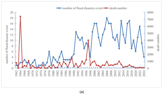
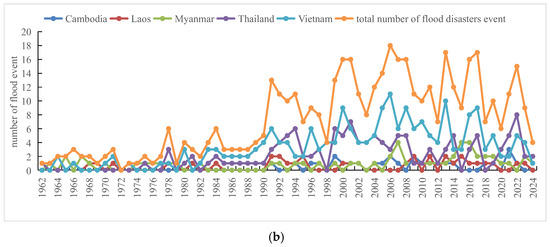
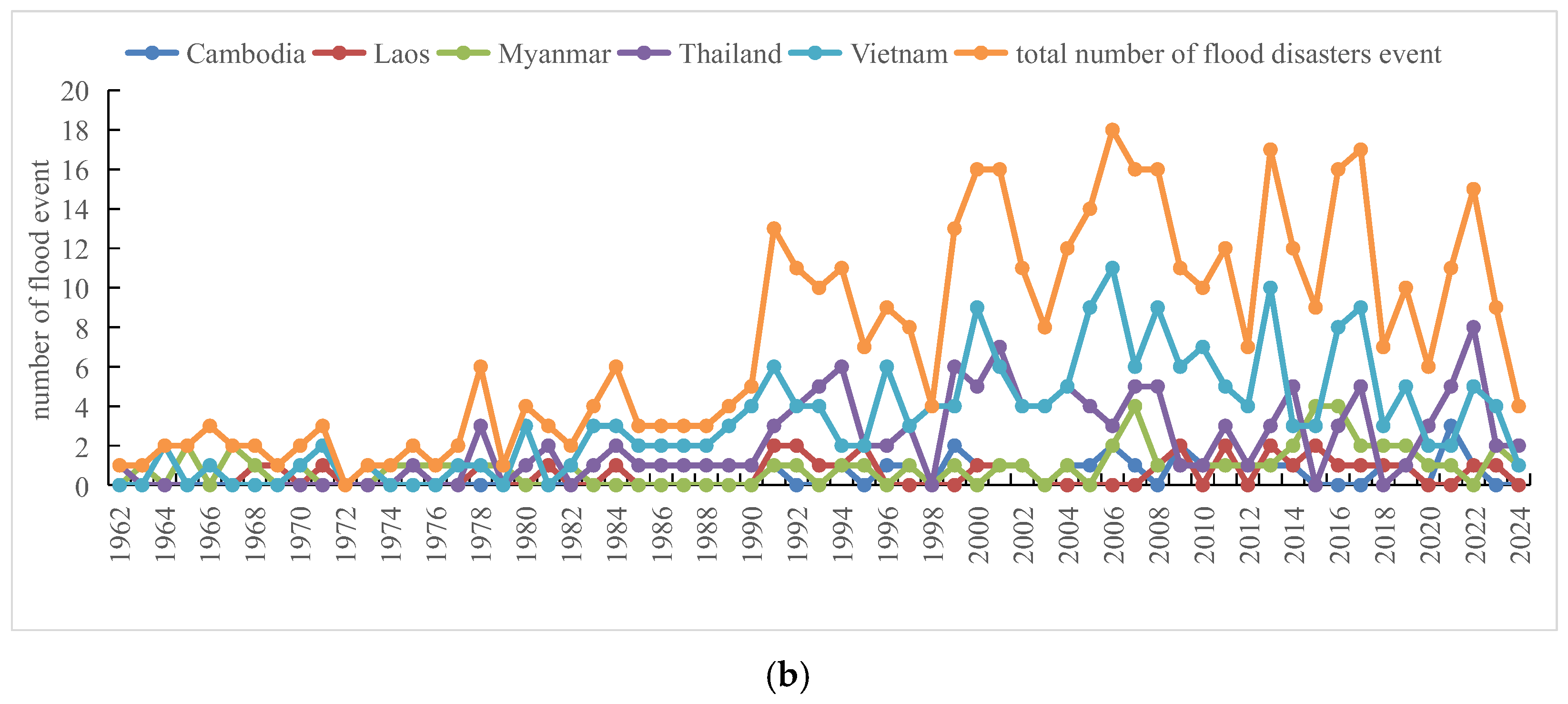
Figure 2.
(a). Temporal variations in total flood occurrences and fatalities in Mekong Basin countries (1962–2024). (b) Annual variations in flood occurrences by country (1962–2024).
The frequency of flood events has shown a sharp increase over the past few decades, with 1990 marking a clear inflection point. Specifically, the average annual number of flood occurrences rose from approximately 3 times in 1962–1989 to about 7.5 times in 1990–2024, representing a growth of over 150%. This significant uptrend reflects the growing exposure to flood risks due to both climate and development pressures in the basin.
Despite increasing flood frequency, the total fatalities have shown a declining trend (Figure 2a). Peak fatality years (e.g., 1966 and 1997) correspond to extreme flood events. Post-2000 fatalities remain relatively low, likely reflecting improved early warning systems and emergency response capacities.
Country-level analysis (Figure 2b) shows Vietnam and Thailand experiencing both highest flood frequencies and greatest numbers of casualties.
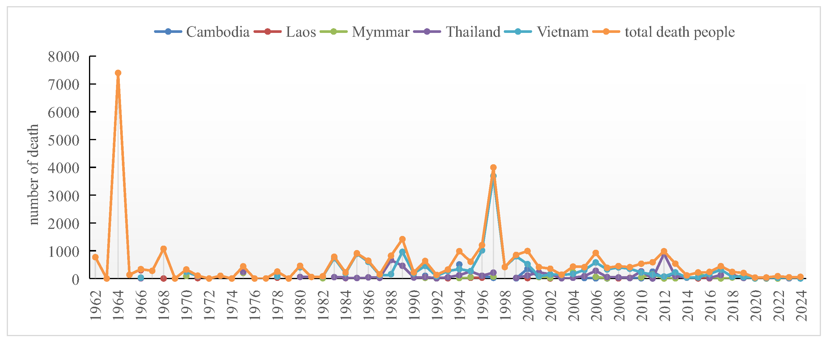
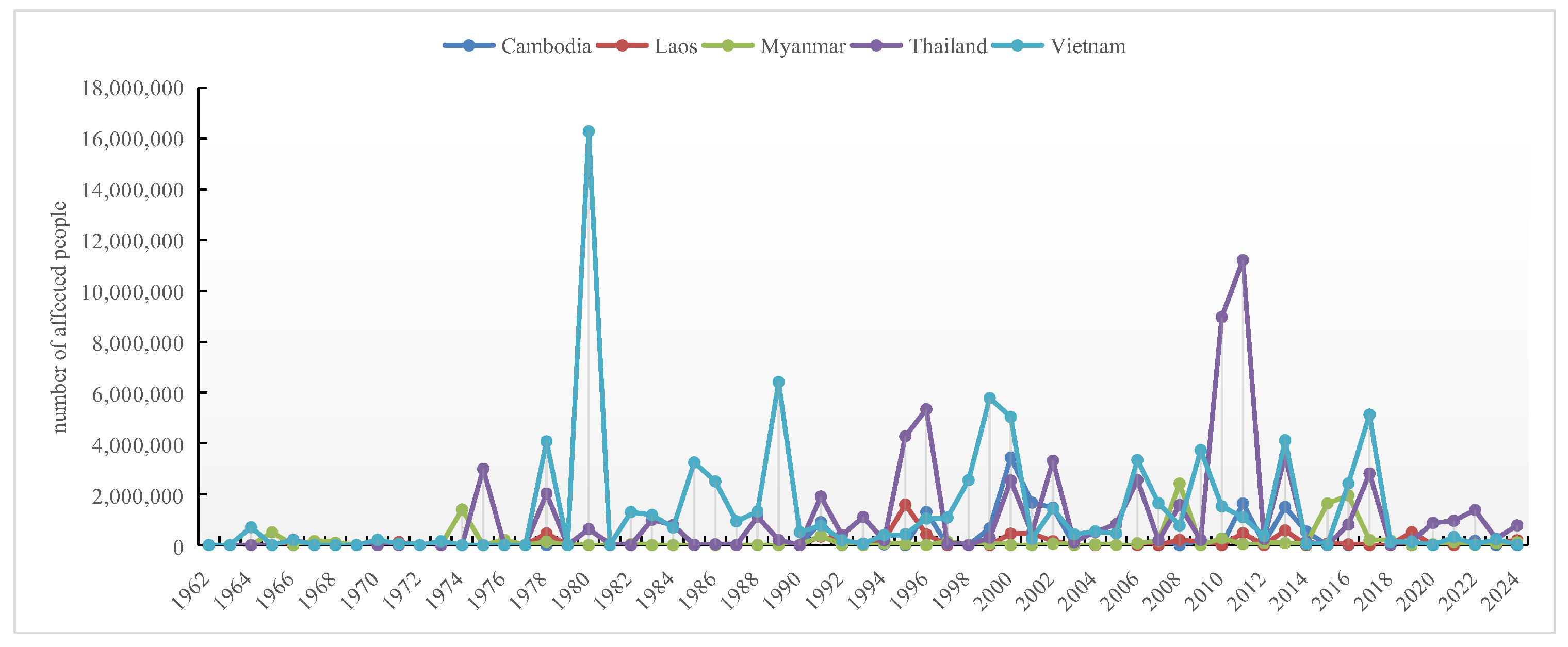
Vietnam consistently experienced years with over ten flood events, with fatalities approaching 8000 in specific extreme years (Figure 3), particularly in the central coast and Mekong Delta regions. Thailand faced catastrophic flooding in 2011, affecting over ten million people, primarily due to continuous heavy rain.
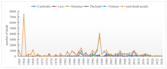
Figure 3.
Annual variations in fatalities caused by floods in Mekong Basin countries (1962–2024).
In contrast, Cambodia, Laos, and Myanmar reported fewer flood events and fatalities (Figure 4). Lower population densities and community-based responses likely contribute to fewer casualties. Vietnam’s disproportionately high fatality toll underscores its vulnerability, especially in coastal regions frequently impacted by tropical cyclones.
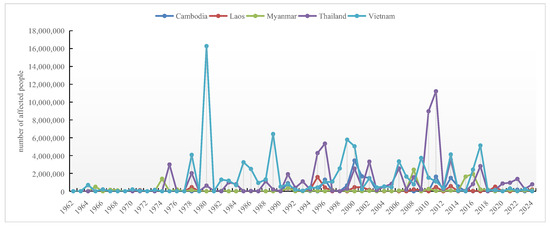
Figure 4.
Annual variations in flood-affected populations in Mekong Basin countries (1962–2024).
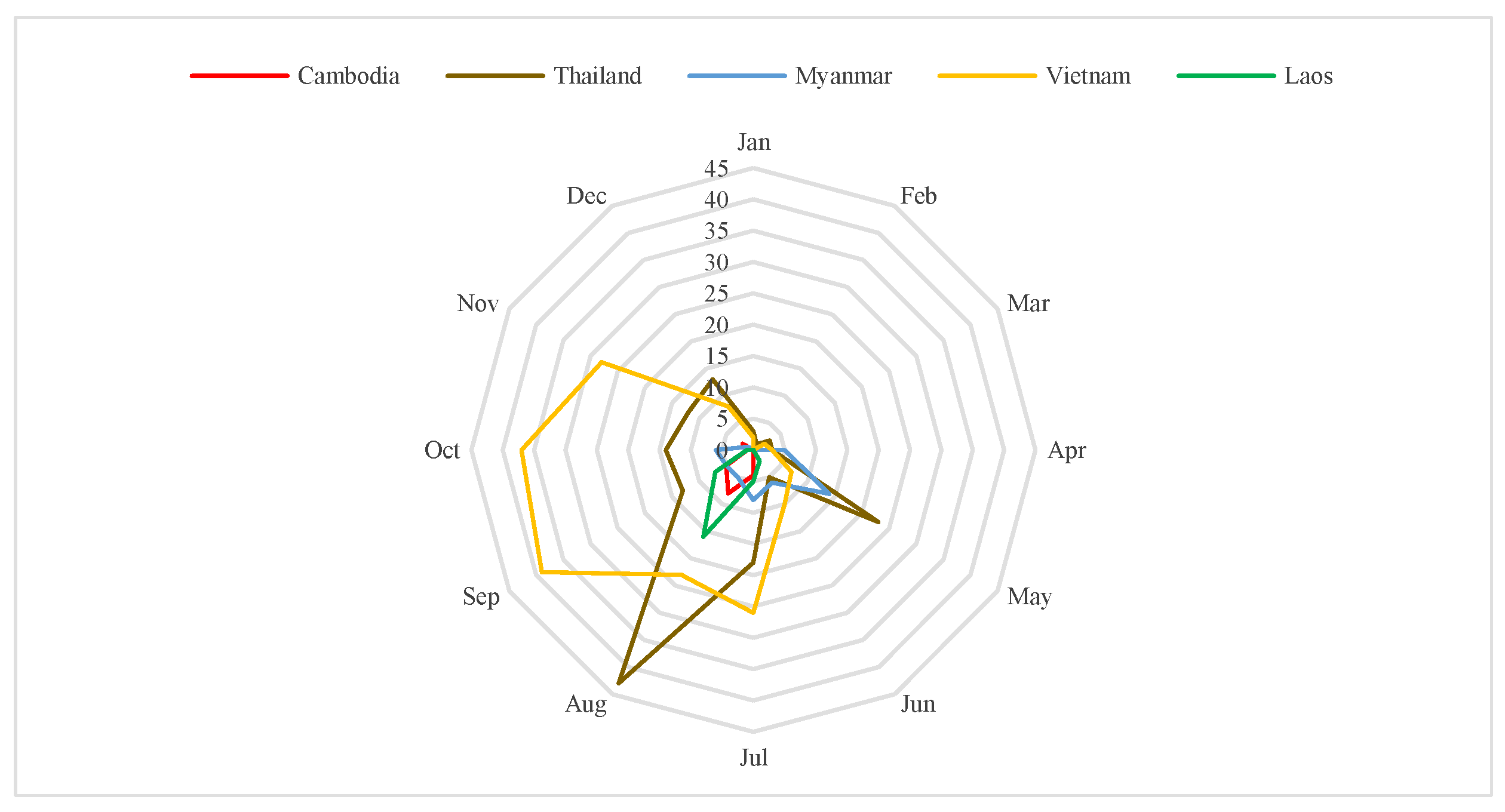
The intra-annual flood occurrence (Figure 5) shows floods predominantly occur between July and November, aligning with rainy seasons. Vietnam and Thailand experience extended flood seasons into December, while Myanmar has a distinct May peak, influenced by Bay of Bengal cyclones. These patterns underscore region-specific preparedness needs.
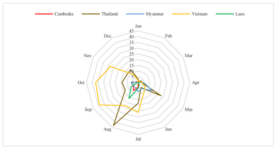
Figure 5.
Intra-annual distribution of flood damages in Mekong Basin countries (1962–2024).
3.2. Spatial Distribution Characteristics of Floods
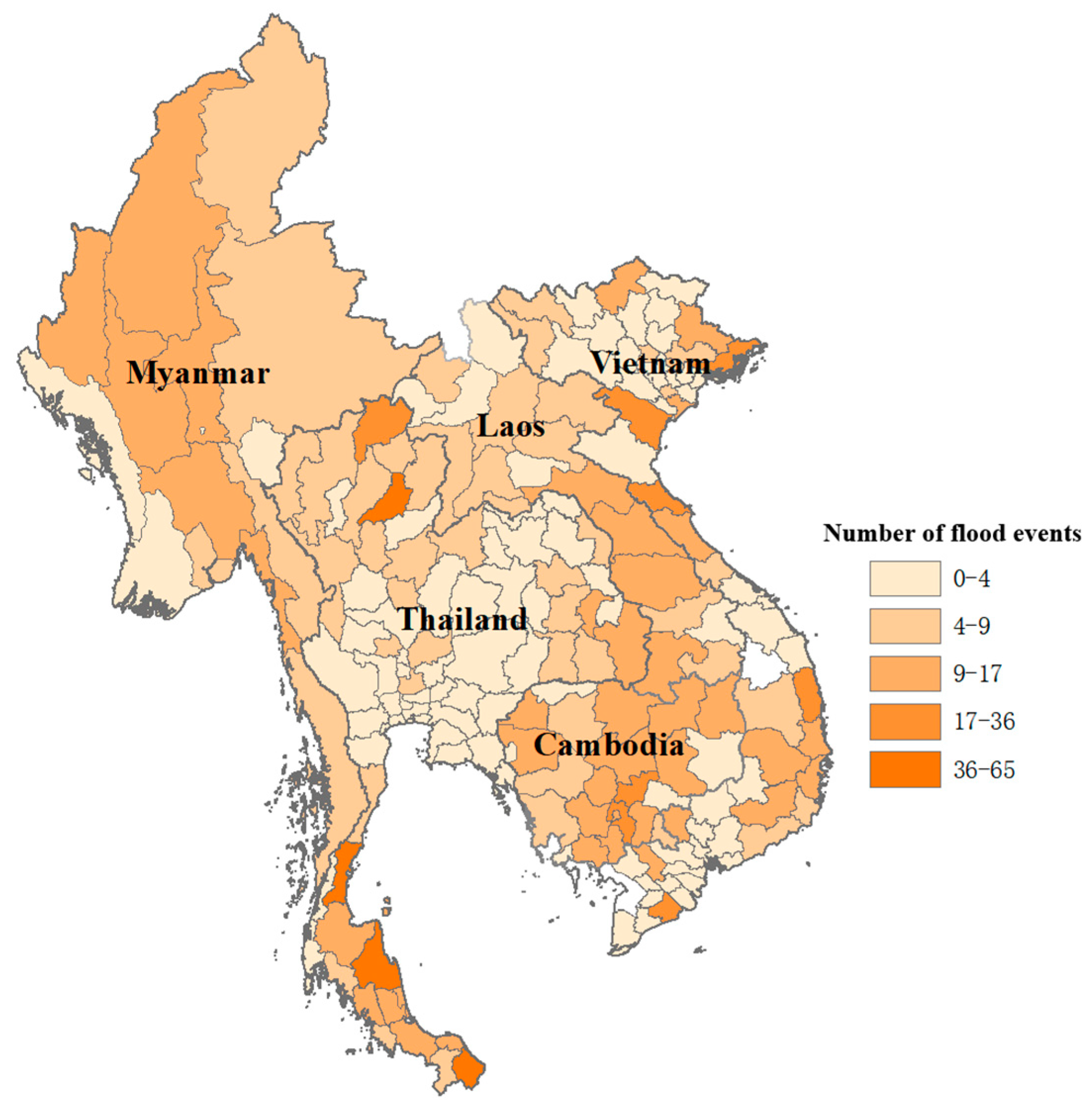
Flood occurrences show distinct spatial heterogeneity across the Mekong Basin (Figure 6). Coastal and deltaic regions of Vietnam are identified as high-risk zones (up to 17 events annually), aligning with low elevation, marine climates, and dense settlements. Laos experiences moderate frequency (8–12 events annually) primarily near the Mekong mainstream. Thailand shows high flood frequency (>12 events) in southern coastal provinces and central Mekong areas. Myanmar exhibits higher frequency in the northwest due to monsoon impacts, decreasing inland. Cambodian floods concentrate around Mekong and Tonle Sap Lake.
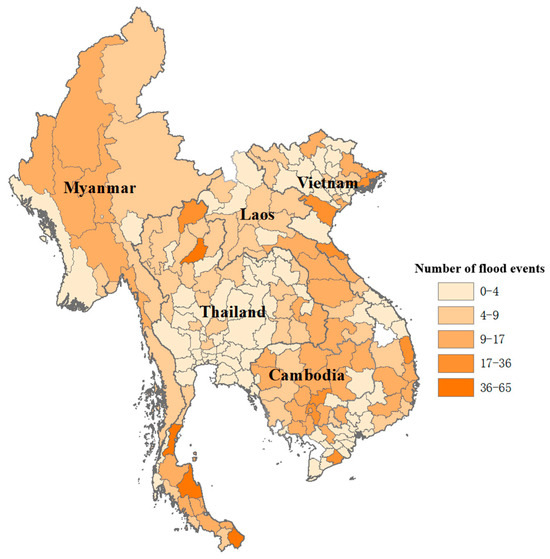
Figure 6.
Distribution of annual flood event frequencies (1962–2024).
These patterns emphasize the need for place-based flood risk management approaches.
3.3. Driving Forces of Flood Disasters
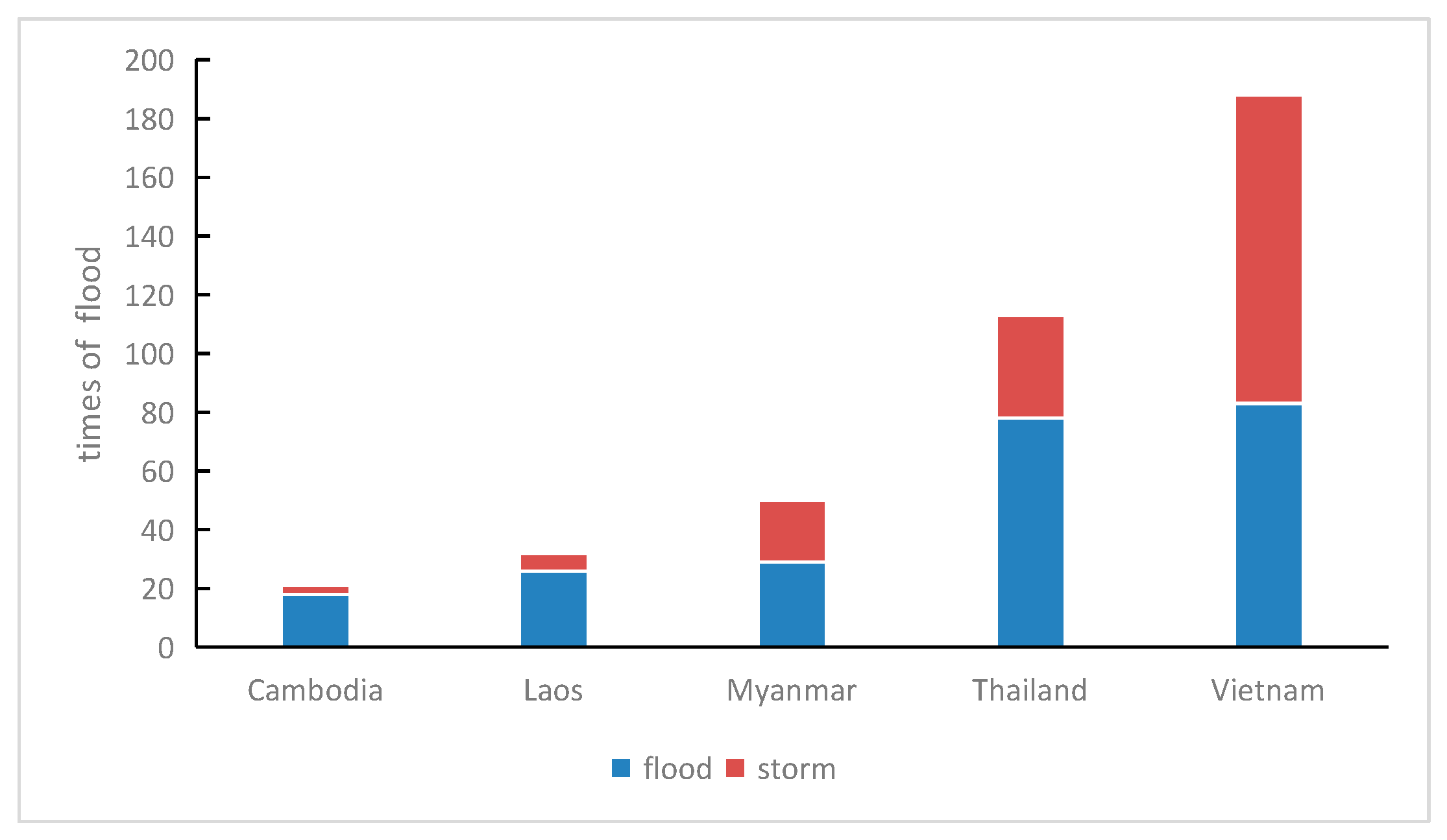
Flood drivers across the Lower Mekong Basin exhibit substantial spatial variability, shaped by diverse climatic regimes and geomorphological settings (Figure 7). The figure specifically illustrates two major types of flood triggers—riverine floods and storm-induced floods—based on event classifications from EM-DAT and ADRC databases. Other flood types, such as flash floods, pluvial (urban) floods, and dam-related flooding, do occur in the region but are less frequently reported and represent a smaller share of total recorded events. As such, they are not the focus of this analysis.
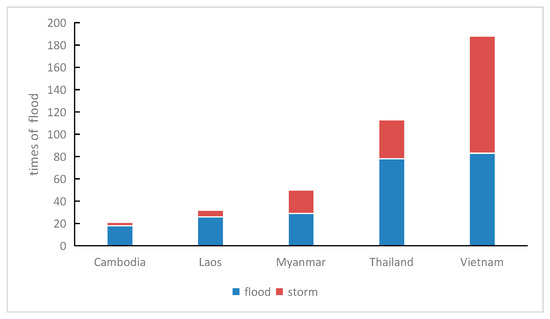
Figure 7.
Flood drivers (riverine floods and storms) in Mekong River Basin countries (1962–2024).
In Figure 7, blue bars represent the number of storm-related flood events, directly corresponding to the left y-axis, which denotes event count. These typically arise from tropical storms and typhoons making landfall, resulting in coastal or inland flooding. Gray bars denote riverine flood events, associated with prolonged monsoon rainfall and upstream basin contributions. This classification reflects documented causes listed per event in the databases.
Vietnam shows a clear dominance of storm-induced flooding, with 105 such events recorded, owing to its long, typhoon-prone coastline and deltaic exposure. Thailand exhibits the highest number of riverine flood events (78), consistent with its central position in the Mekong hydrological network and its extensive lowland floodplain. Laos and Cambodia are predominantly affected by river floods, while Myanmar demonstrates a relatively balanced flood trigger profile—storm-induced events are notably frequent in its northwestern regions due to tropical cyclones originating from the Bay of Bengal.
This differentiation of flood types is critical for tailoring risk mitigation strategies, as storm-induced and riverine floods often require distinct forecasting, infrastructural, and institutional responses.
3.4. Assessment of Coping and Adaptive Capacity to Flood Disasters
In addition to natural hydrometeorological conditions, socio-economic transformations—such as rising population density, accelerated urbanization, and forest-to-agriculture land conversion—have exacerbated flood risks across the Mekong River Basin. These anthropogenic drivers, combined with regional climatic diversity influenced by tropical monsoons and marine conditions, result in country-specific flood dynamics. For example, Vietnam’s elongated coastline makes it vulnerable to tropical storms, while Myanmar experiences both riverine and coastal flooding influenced by the Bay of Bengal. Thailand and Laos are mainly impacted by river overflows, whereas Cambodia’s flat terrain makes it prone to poor drainage and prolonged inundation.
3.4.1. Evaluation Index System
The composite flood risk assessment framework is grounded in classical risk theory (i.e., Risk = Hazard × Exposure × Vulnerability/Coping Capacity), as widely adopted in leading frameworks [36,37]. To facilitate clear expression, the study summarizes this into the following functional form:
F (Flood Risk) = f (Hazard, Susceptibility, Exposure, Coping Capacity).
Each dimension includes representative sub-indicators:
- Hazard: Rainfall intensity and frequency (e.g., annual precipitation, max 1/3/5-day rainfall).
- Environmental Susceptibility: Terrain index, hydrological network index, vegetation cover; emphasis on land use change (especially cropland and forest).
- Exposure: Population density, GDP per capita.
- Coping Capacity: Working-age population ratio, GDP per capita (as proxies for disaster preparedness and recovery potential).
3.4.2. Risk Analysis on Flood Disasters
Hazard Factors: Rainfall Intensity and Frequency
R. Osti and S. Hishinuma et al. [2] analyzed long-term rainfall data (1961–2007) across parts of South and East Asia, revealing that most countries showed no clear trend in annual rainfall totals, with many time series lacking significant directional change. However, maximum 3-day and 5-day rainfall volumes have shown an increasing trend in many countries. This suggests that with global warming, short-duration heavy rainfall events are becoming more frequent, thereby increasing the probability of flood disasters.
Environmental Susceptibility
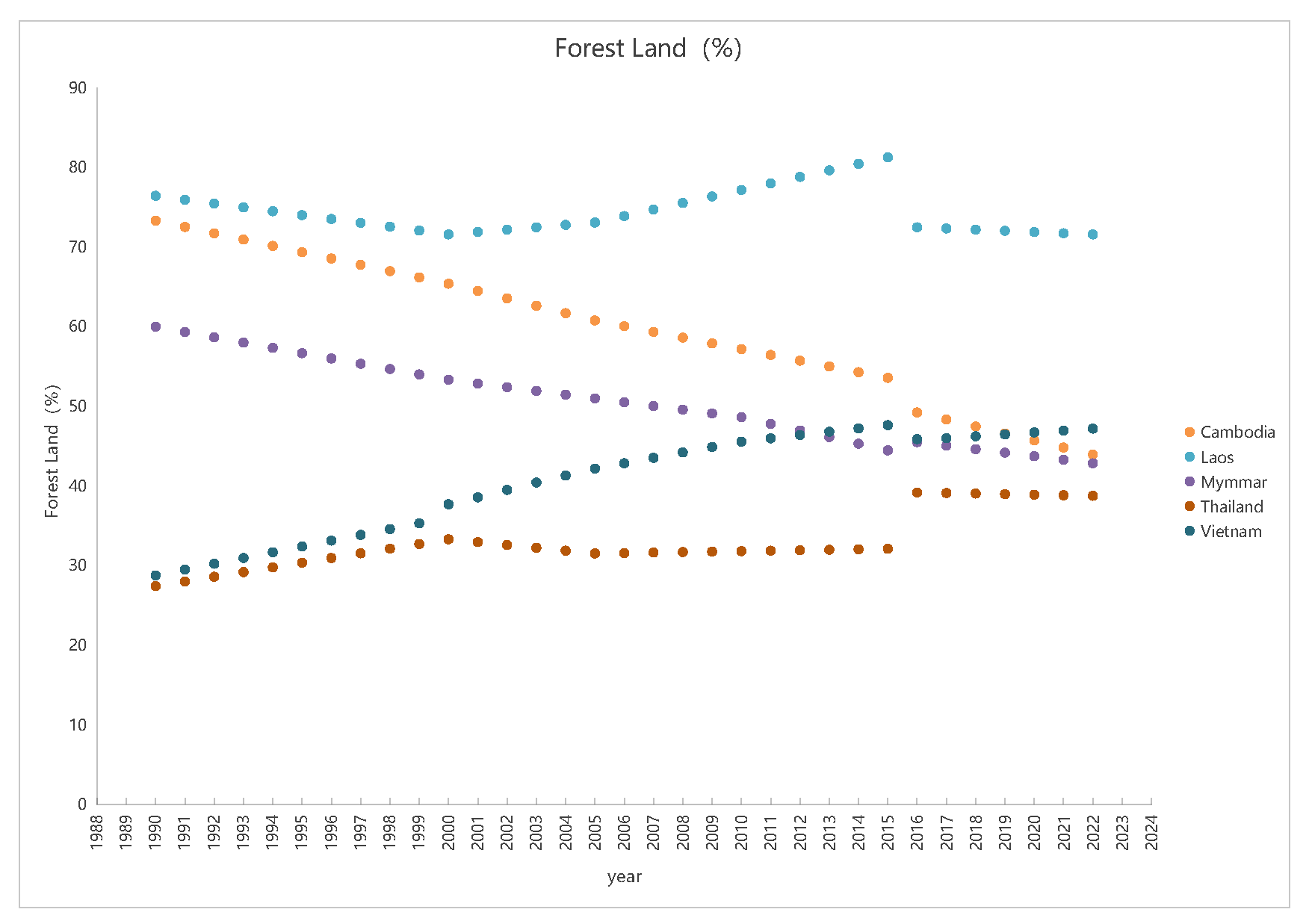
Figure 8 shows the changes in forest and agricultural land cover proportions in the five countries of the Mekong Basin. Forest cover in Vietnam has steadily increased, largely due to national forest recovery and vegetation management initiatives such as the “Forest Coverage Promotion Plan” [25], which significantly enhanced natural flood regulation capacity. However, this increase in forest cover does not appear to have resulted in a notable reduction in the frequency of flood events (Figure 2a). One possible explanation is that while reforestation improves long-term watershed retention and soil stability, its effects on extreme flood events are often limited, especially when other drivers—such as urban expansion, climate change-induced rainfall intensity, and upstream hydrological alterations—exert stronger influence. Additionally, many reforested areas are located in upland or mountainous regions, whereas flood-prone zones are typically concentrated in low-lying urban or deltaic areas where forest regulation has limited direct effect. Laos experienced a decline followed by a recovery in forest area, strongly associated with transboundary cooperation projects like UNDP-supported reforestation initiatives, which have played a critical role in mountain flood control [28,32]. Thailand’s forest cover has remained relatively stable, supported by strict conservation policies and logging bans, although agricultural expansion has challenged ecological restoration in certain areas. In contrast, Cambodia and Myanmar have seen significant forest loss, driven by rapid agricultural expansion, illegal logging, and urbanization, which has directly weakened flood buffering capacity and increased downstream flood risk.
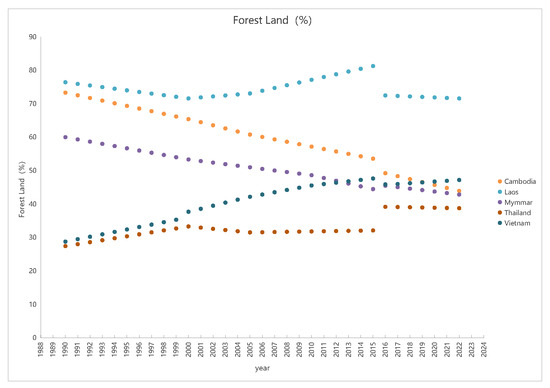
Figure 8.
Forest cover proportions in Mekong Basin countries (1962–2022).
Vietnam’s forest cover increased by 9.5% from 2000 to 2022, yet this expansion has not significantly reduced flood frequency in the same period. In contrast, Cambodia and Myanmar experienced substantial deforestation, with forest cover declining by 21.5% and 10.5% in the two countries respectively over the same timeframe. However, research suggests that such losses contribute to heightened flood risks in downstream regions, though local infrastructure and rainfall patterns also play critical roles.
Declining forest cover reduces soil infiltration capacity, increases surface runoff, and shortens flood concentration time, while also weakening ecosystems’ ability to buffer extreme rainfall events [38]. These changes not only intensify flood frequency and severity but also alter upstream-downstream flood dynamics. These land cover changes not only intensify the frequency and severity of floods but also reshape upstream–downstream hydrological interactions. For example, extensive deforestation in upstream countries such as Laos and Cambodia increases runoff and sediment loads, elevating flood pressure in downstream regions like Thailand and Vietnam. In contrast, Vietnam’s forest recovery has somewhat alleviated local flood risk through enhanced infiltration and slope stabilization [38]. Furthermore, Winsemius et al. [38] highlighted that regional land use changes and urbanization further complicate the propagation of flood disasters.
Agricultural Land Expansion and Hydrological Impacts
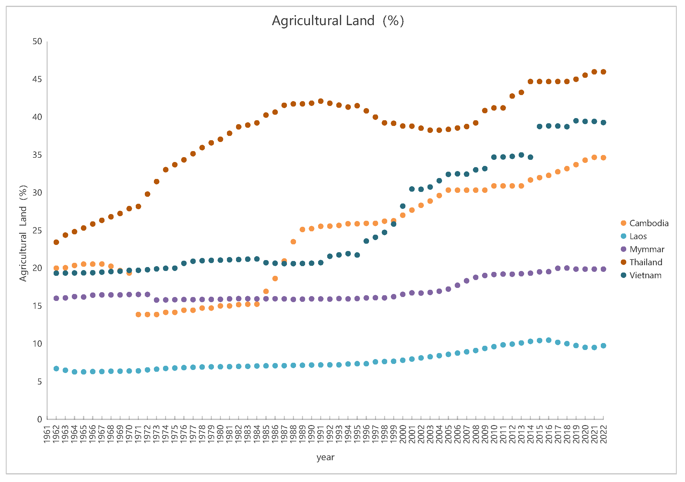
Figure 9 illustrates a general upward trend in agricultural land cover across the five countries of the Mekong River Basin, with distinct spatial and temporal patterns. In Cambodia, steady agricultural expansion has been driven by rice and cash crop cultivation, often at the cost of forest clearance and habitat degradation. Vietnam’s Mekong Delta has experienced an accelerated increase in agricultural land use since 1998, largely attributable to state-led agricultural modernization and food security initiatives, particularly in rice farming and aquaculture. Thailand exhibited rapid agricultural growth in the late 20th century, followed by stabilization due to industrialization and urbanization. In contrast, agricultural expansion in Myanmar and Laos has remained modest, constrained by underdeveloped infrastructure and mountainous terrain, respectively. The transition of land use from forests to agricultural areas has profound implications for flood management and water resources. Understanding these changes is critical for devising strategies that balance agricultural expansion with flood risk reduction.
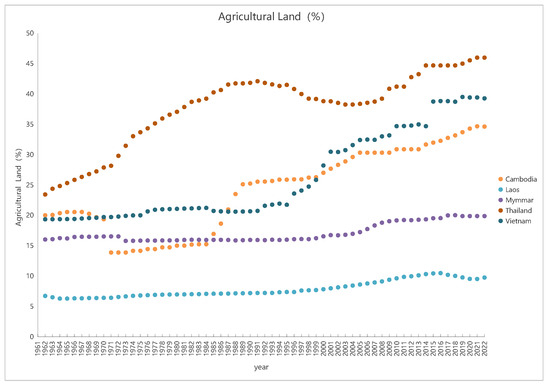
Figure 9.
Agricultural land cover proportions (1962–2022).
This land use transition has significant implications for the region’s hydrological regulation capacity. The conversion of wetlands and floodplains into agricultural areas reduces soil infiltration, intensifies surface runoff, and ultimately increases both the frequency and severity of flood events [27,38]. In Vietnam, for example, agricultural encroachment into flood retention zones has diminished flood absorption capacity [27,30], while expansion in Cambodia has exacerbated downstream flood risks [39,40,41]. Moreover, uneven agricultural expansion between upstream (e.g., Laos, Myanmar) and downstream (e.g., Vietnam, Thailand) countries has disrupted the spatial equilibrium of water resources and altered basin-wide flood propagation patterns. As shown in Figure 9, Vietnam’s agricultural land ratio surged after 1998, while Thailand’s growth plateaued after the early 1990s [29,30]. Overall, the decline in forest cover and the shift toward cropland contribute to altered natural hydrological regimes and increased vulnerability of agricultural systems to flood-related damage [27,33,42].
Several abrupt year-to-year changes in land cover trends warrant explanation. In Laos, the approximately 10% decline in forest cover observed in the early 2000s may be linked to a surge in logging concessions and rapid expansion of cash crop plantations, particularly rubber and banana farming, which accelerated deforestation during this period. Conversely, the ~10% increase in Thailand’s forest cover over a similar timeframe reflects strong national reforestation policies and community forestry initiatives implemented after 1997, including protected area expansion and incentives for afforestation.
The sharp drop in Cambodia’s agricultural land area likely corresponds to land reclassification in national datasets, where previously cultivated floodplains or seasonal wetlands were re-designated as non-agricultural due to prolonged flooding or conservation zoning changes. As for Thailand’s agricultural land, the observed short-term dip followed by resumed growth may reflect temporary disruptions from flood events (e.g., the 2011 mega-flood), after which land use returned to pre-disaster patterns. These fluctuations highlight the importance of interpreting satellite-derived land cover data in conjunction with national land use policies and extreme climatic events.
Exposure and Vulnerability
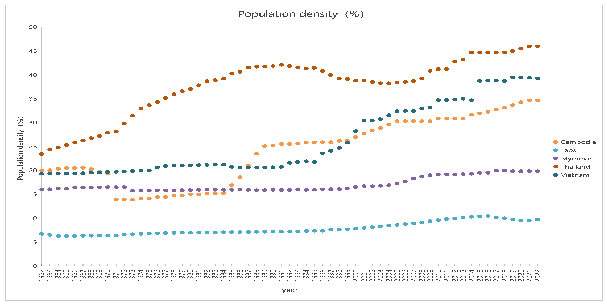
Population density (Figure 10) has risen markedly across all five countries, with Vietnam exhibiting the highest growth. High-density settlements in flood-prone areas—such as the Mekong Delta—have significantly elevated exposure levels and disaster vulnerability [27]. In Cambodia and Myanmar, densely populated riparian agricultural zones face dual challenges of ensuring food security and mitigating recurrent flood risks [43,44]. Even in relatively low-density countries like Laos, the concentration of populations in river valleys has created localized hotspots of flood exposure [45].
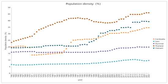
Figure 10.
Population density trends (1962–2024).
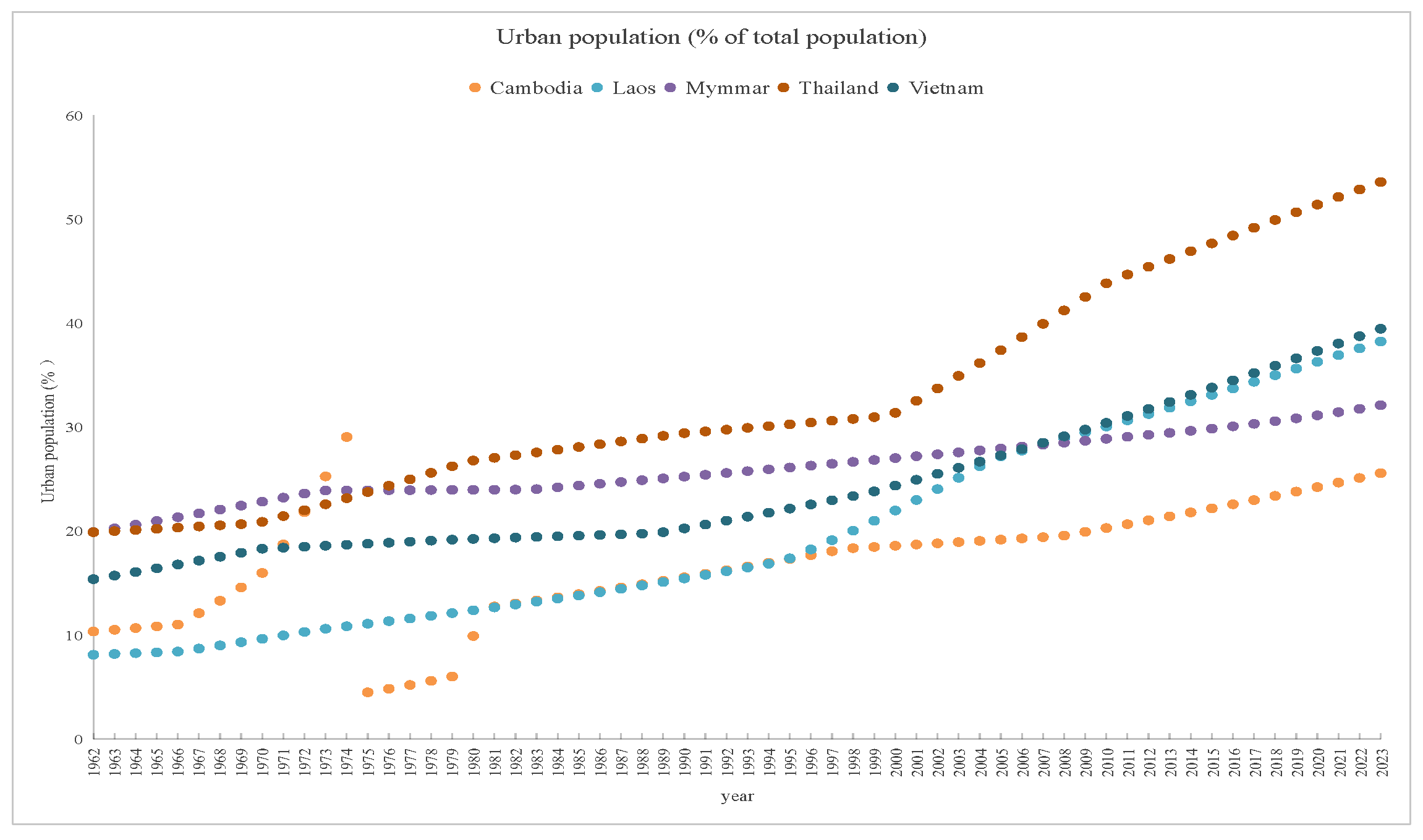
Urbanization (Figure 11) has accelerated particularly in Laos, Thailand, and Vietnam. Urban sprawl reduces natural floodplain storage, increases impervious surface areas, and exacerbates urban flood risks, as evidenced in cities such as Bangkok and Ho Chi Minh City [27,31]. In Laos and Cambodia, infrastructure development has lagged behind rapid urban growth, increasing the population’s exposure to flood hazards [24,45]. Even in countries with more established urban centers—such as Vietnam and Thailand—flood defense systems often fall short of urbanization pace, undermining resilience efforts [24,31]. The rapid urbanization and population growth in flood-prone areas underscore the urgent need for integrated flood risk management that combines land use planning, urban design, and flood defense infrastructure. Furthermore, socio-economic development trends have increasingly influenced transboundary flood transmission dynamics. Upstream land use changes such as deforestation in Laos and Myanmar have intensified downstream flood risks, particularly in low-lying areas of Vietnam [38,41]. These developments underscore that basin-wide flood vulnerability is no longer solely shaped by geography or hydrology but increasingly defined by population distribution, urban planning, and infrastructure investment patterns [24,27,33].
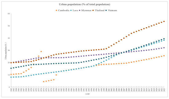
Figure 11.
Urban population trends (1962–2024).
Disaster Prevention and Mitigation Capacity
The flood disaster response capacity of countries in the Mekong River Basin critically determines their effectiveness in managing and recovering from flood events. Three widely recognized indicators—Human Development Index (HDI), GDP per capita, and the proportion of working-age population (15–64 years)—are commonly used to evaluate national coping capacity. The HDI reflects levels of public awareness, education, and institutional responsiveness to disasters; GDP per capita signals available economic resources for investing in resilient infrastructure and technology; and the working-age population ratio indicates the labor force available for emergency operations.
- (a)
- GDP per Capita and Infrastructure Investment
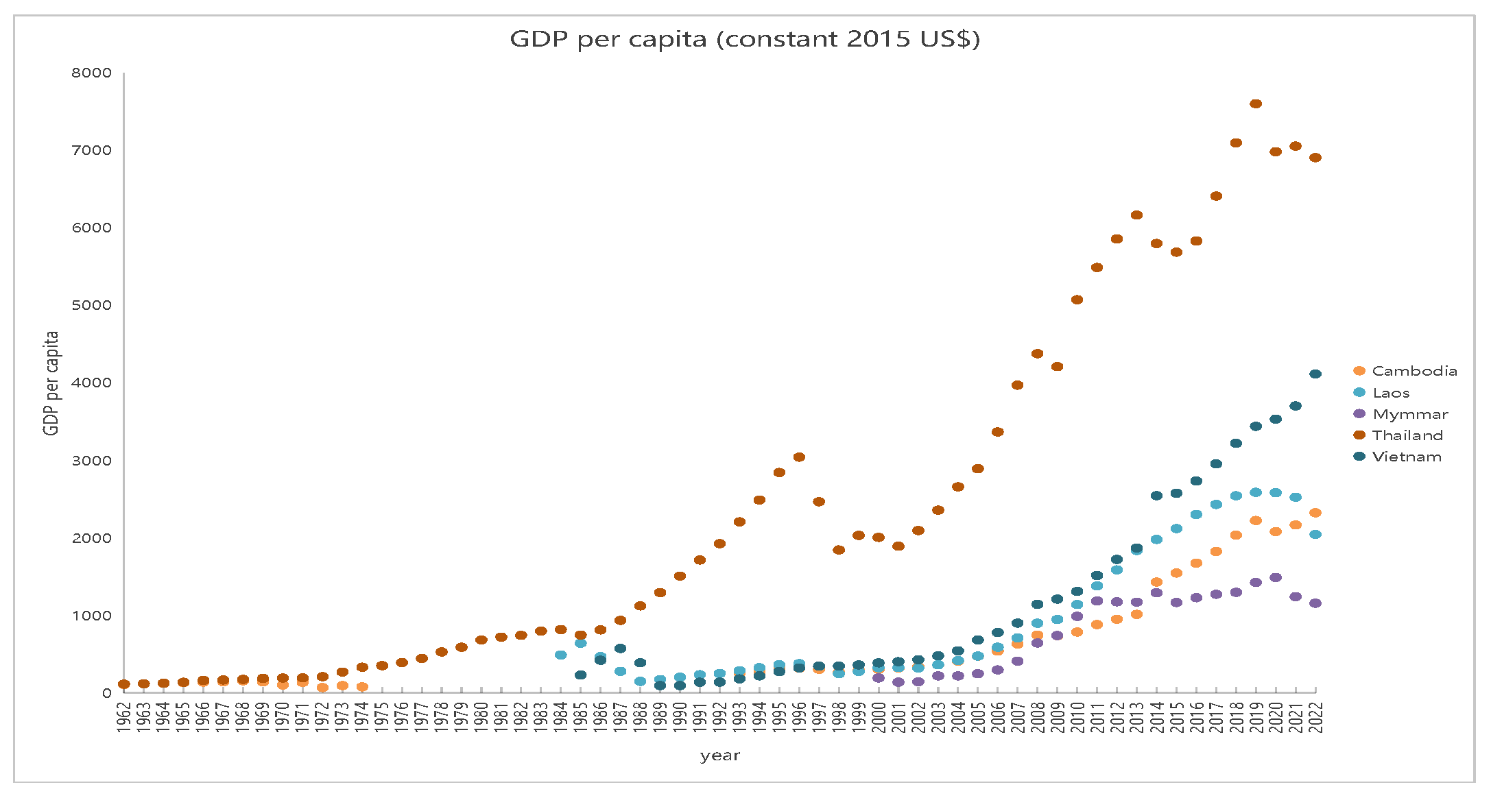
Economic capability, as measured by GDP per capita, directly affects a country’s ability to invest in flood mitigation infrastructure. Higher-income nations generally maintain more sophisticated drainage networks, early-warning systems, and disaster recovery funds. Thailand and Vietnam, both exhibiting rising GDP trends (Figure 12), have significantly expanded their investments in water resource management and flood defenses [24,46]. Conversely, Cambodia and Laos continue to face financial constraints. Cambodia still depends largely on natural floodplains with limited structural protection, while Laos has prioritized hydropower development for energy export over flood control infrastructure [25,32]. These disparities in fiscal capacity reinforce the infrastructural and institutional vulnerabilities of the lower-income countries in the basin. Regional frameworks such as the Lancang–Mekong Cooperation (LMC) offer potential mechanisms to promote financial and technical support across member states [25,31]. From 2000 to 2023, Thailand’s GDP per capita surged by 268% (2007→7182 USD), while Vietnam’s grew even more rapidly by 746% (388→4282 USD). In contrast, Cambodia’s growth, though substantial at 704% (302→2429 USD), remained significantly lower in absolute terms. This stark economic disparity underscores the divergent capacities for infrastructure investment and flood resilience across the region.
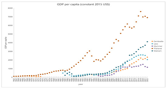
Figure 12.
GDP per capita trends (1962–2022).
- (b)
- Working-age Population and Emergency Response
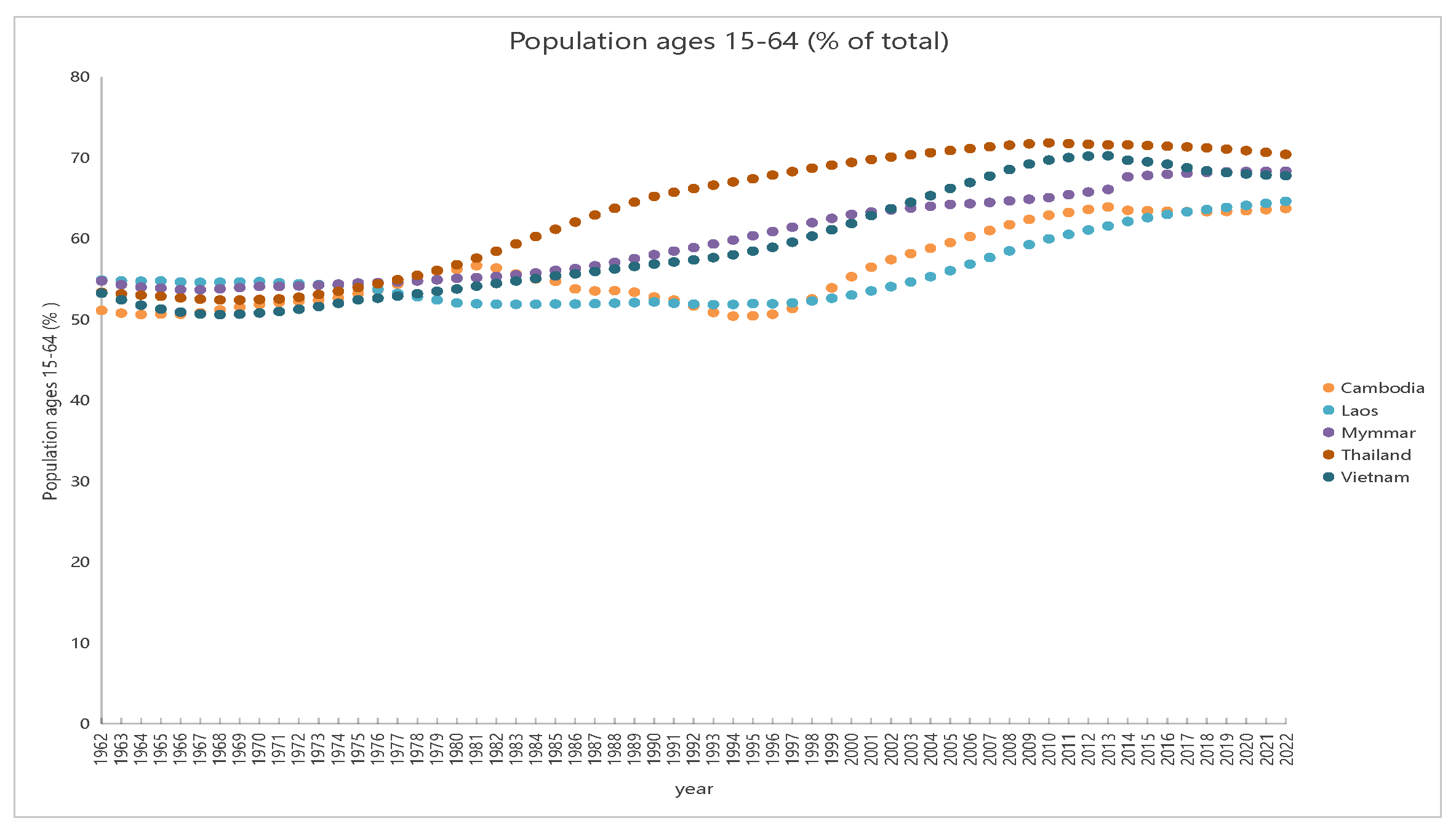
A high proportion of working-age individuals (15–64 years) provides vital labor resources for flood preparedness, emergency mobilization, and post-disaster reconstruction. Laos and Cambodia possess relatively high youth ratios, theoretically offering substantial labor potential during flood crises. However, poor infrastructure and limited coordination hinder the effective deployment of these resources [25,32]. Thailand and Vietnam, despite having slightly older demographic profiles, display stronger institutional preparedness and disaster governance structures [24,36]. Urbanization-driven labor shifts from rural to urban regions—especially in Vietnam and Cambodia—have also weakened local emergency capacities in rural and flood-prone areas [32,43]. As shown in Figure 13, all five countries exhibit relatively high and stable working-age population proportions, indicating that labor availability is not the primary constraint; instead, infrastructure investment and inter-agency coordination remain the main bottlenecks in disaster response capacity [28,32].
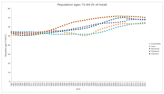
Figure 13.
Working-age population ratios (1962–2022).
Since 2000, the proportion of the working-age population (aged 15–64) in Thailand (brown) and Vietnam (dark blue) has stabilized at around 70% of the total population; while the proportion of the working-age population in Cambodia (orange) and Laos (light blue) was initially relatively low. Then it showed an upward trend, gradually approaching 70% by 2020, and has remained relatively stable since then. This slowdown in the growth of the working-age population proportion suggests persistent challenges in labor force utilization.
- (c)
- HDI and Disaster Resilience
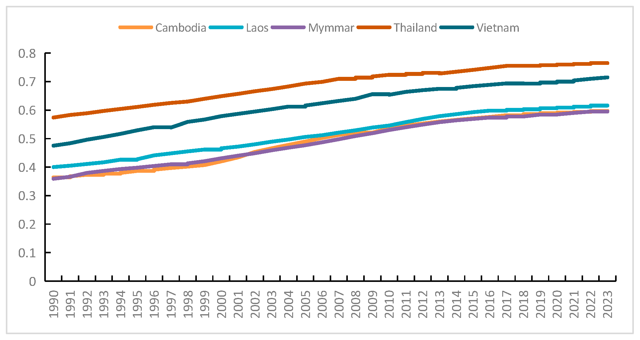
In terms of flood resilience, a higher HDI usually means a stronger awareness of disasters, a more refined education system, and more robust public health infrastructure. Figure 14 shows a steady upward trend in HDI scores for all five countries from 1990 to 2023.Judging from the trend of the curves in the graph, Thailand demonstrates a stronger adaptive capacity, with its HDI remaining at a relatively high level for a long time; Vietnam also shows a good performance. However, due to their relatively low starting points in social development, although the HDIs of Cambodia and Myanmar are on an upward trend, their absolute values are still lower than those of Thailand and Vietnam, leaving them in a relatively vulnerable state [32].
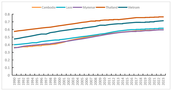
Figure 14.
HDI scores in Mekong Basin countries (1990–2024).
From 1990 to 2023, Thailand’s HDI score has increased significantly, reflecting its remarkable progress in the fields of health, education, and infrastructure; Vietnam has made outstanding progress, with its HDI continuously climbing; although Cambodia and Myanmar started from low bases, they have achieved a certain degree of growth. It should be noted that despite the upward trend of their HDIs, the HDIs of Cambodia and Myanmar in 2023 were still lower than those of Thailand and Vietnam, highlighting the persistent gaps in the basic development areas that “affect disaster prevention and adaptive capacity” in these countries. The steady improvement of Laos’ HDI reflects the steady development of regional resilience-building efforts.
Despite Thailand and Vietnam having higher HDI levels—indicating stronger overall capacity in education, health, and living standards—they continue to suffer the greatest flood-related losses in the Mekong Basin. Each major flood event results in substantial human casualties and economic disruption. This highlights that HDI alone is not a definitive predictor of flood damage outcomes. Flood losses are influenced by multiple factors including GDP per capita, demographic composition, and population density. Both Thailand and Vietnam concentrate economic activity in low-lying, high-risk areas such as the Mekong Delta, where high population and GDP density lead to amplified disaster losses. Furthermore, although both countries benefit from sizable working-age populations, high proportions of elderly and children—more vulnerable segments—exacerbate social vulnerability. Urbanization and population clustering intensify pressure on disaster management and resource allocation, presenting ongoing challenges.
3.4.3. Current Capacity of Flood Control
This subsection evaluates the current structural flood control capacity of each Lower Mekong Basin country and compares it to actual flood event impacts, aiming to explore whether disparities in infrastructure and governance contribute to observed differences in flood risk.
Cambodia remains highly vulnerable to floods and records one of the highest frequencies and severities of flood impacts in the region (Figure 2b). Despite having a multi-tier disaster response system, its structural defenses are underdeveloped outside of Phnom Penh and several provincial centers. The per capita reservoir storage is only 0.01 m3/person, far below the global average of 1000 m3/person [33,34]. Although Tonle Sap Lake and surrounding floodplains offer significant natural retention capacity, rapid urban encroachment and land use change are undermining their buffering effect [47]. The high flood impact observed in Cambodia aligns with its weak structural capacity, suggesting a strong link between inadequate engineered infrastructure and elevated flood risk. Cambodia’s per capita reservoir storage of 0.01 m3/person is substantially lower than Thailand’s 155 m3/person and Vietnam’s 120 m3/person, indicating a significant infrastructure gap that directly contributes to higher flood vulnerability [48].
Laos, in contrast, has a national-to-local disaster management framework and ranks among the global leaders in per capita hydropower reservoir storage, estimated at 11,060 m3/person [36]. However, most of these reservoirs prioritize energy production over flood control and provide limited flood regulation downstream [37]. Despite this, Laos experiences fewer fatalities and smaller affected populations compared to Cambodia (Figure 2b), likely due to its mountainous terrain, lower population density in flood-prone areas, and early warning mechanisms developed after the 2018 dam collapse. This suggests that structural storage alone may not directly translate to lower flood impacts unless flood regulation is explicitly integrated. The high per capita hydropower reservoir storage in Laos of 11,060 m3/person illustrates its superior infrastructure capacity compared to Cambodia, yet Laos still experiences less than half the fatalities of Cambodia, demonstrating the importance of integrating flood control with broader disaster management strategies.
Myanmar operates under the NDPCC and partners with Red Cross and meteorological agencies to manage flood risks. Structural defenses are more established along the Irrawaddy and Salween Rivers, but remain limited in the Mekong portion. Nevertheless, Myanmar records moderate flood frequency and lower casualty rates, indicating that regional topography, cyclone preparedness, and community-based responses contribute to resilience despite structural gaps [35,38].
Thailand demonstrates high structural capacity in the Mekong region, with embankments protecting 31% of riverbanks and a well-developed disaster response system. However, its per capita reservoir storage is only 155 m3/person, and regulatory effectiveness is challenged by fragmented institutional mandates. Despite this, Thailand manages to mitigate impacts through robust meteorological and hydrological monitoring networks [42], showing that institutional and technical capacity can partially compensate for structural limitations.
Vietnam, with over 10 reservoirs operating in the Mekong Basin mainly for hydropower, faces high exposure due to its low-lying delta. However, proactive interventions such as housing elevation, resettlement programs, and strengthened flood forecasting systems have significantly reduced human losses [30]. The legal framework for disaster risk reduction is comprehensive, though limited flood storage still constrains regulatory control.
Overall, structural flood control capacity varies widely across the basin and correlates with observed flood impacts to varying degrees. Cambodia’s minimal infrastructure corresponds to high vulnerability and repeated severe impacts. Laos’s large storage capacity is not fully effective due to design priorities, yet lower exposure mitigates consequences. Thailand and Vietnam illustrate how monitoring systems and adaptive governance can reduce flood impacts even under moderate structural capacity, while Myanmar balances limited defenses with regional cooperation and terrain-driven resilience.
4. Key Findings and Policy Implications
In view of the frequent and far-reaching impact of flood disasters on countries in the Mekong River Basin, this study uses publicly available flood bulletin data from the Asian Disaster Reduction Center (ADRC), United Nations Office for the Coordination of Humanitarian Affairs (UNOCHA), the Mekong River Commission (MRC), and national governments. Flood frequency, death tolls, and affected population numbers are adopted as representative evaluation indicators to quantitatively assess flood-related losses in each country and across the basin. This analysis provides a foundation for developing targeted flood control strategies.
Key Findings
- (1)
- Over the past 60 years, the frequency of flood disasters in the Mekong River Basin has shown an increasing trend, while overall casualties have decreased significantly. The frequency and severity of floods vary across countries, and flood events do not occur synchronously. Temporally, Laos, Myanmar, and Cambodia experience peak floods from July to November, while Vietnam and Thailand are affected throughout the year, though also mainly between July and November. Spatially, Vietnam, Thailand, Myanmar, and Cambodia experience frequent floods, with Vietnam showing the highest concentration of flood-prone provinces, especially in its central region and in Cambodia.
- (2)
- Although Cambodia, Laos, Myanmar, Thailand, and Vietnam all lie within the Mekong River Basin, the causes of floods differ across countries due to variations in geography, regional conditions, and climate. In Vietnam, floods are primarily caused by storms, followed by riverine flooding. In Myanmar and Thailand, riverine floods are dominant, with storms contributing significantly. Mirza (2003) observed analogous hydrometeorological drivers in Bangladesh’s extreme floods, underscoring the role of regional climate patterns in flood generation [49]. In Laos and Cambodia, riverine floods are also the main driver, with storms accounting for 10~20% of events.
The five countries are tightly connected by the Mekong River, but differences in land occupation, population distribution, and geographic location lead to varying degrees of flood exposure and damage. This study’s main contribution lies in compiling a national-level flood disaster database for the Mekong Basin using international disaster datasets, thereby revealing the temporal and spatial distribution of flood losses in each country. These insights support more informed, localized flood mitigation and governance strategies moving forward.
5. Discussion
This study, by integrating multiple data sources, analyzed the spatiotemporal distribution and loss characteristics of flood disasters in the Mekong River Basin and identified key driving forces and regional disparities. The analysis reveals that different disaster databases (e.g., EM-DAT, MRC, and national data sources) exhibit inconsistencies in spatial coverage and statistical standards. EM-DAT, with its long time series and broad spatial scope, is well-suited for identifying basin-wide flood trends but lacks precision in local-scale assessments. In contrast, MRC and country-level datasets provide more detailed and accurate event-based records, enabling better analysis of regional flood impacts.
To address these discrepancies and enhance analytical transparency, macro-scale temporal trends were assessed using EM-DAT, while localized exposure and flood loss assessments relied on MRC and national statistical datasets. The combination of these multi-scale datasets strengthens both large-scale trend analysis and micro-level impact evaluation, facilitating more robust insights for flood risk governance.
Nevertheless, several limitations remain. The completeness and timeliness of international public data need improvement, particularly for early-stage flood records, which often suffer from statistical gaps or underreporting, limiting the accuracy of trend analysis. Furthermore, the lack of sub-national or high-resolution flood damage data—especially concerning affected agricultural areas and economic losses—restricts fine-scale spatial assessments. These issues are not unique to the Mekong Basin but reflect a global data gap. Ward et al. noted that many flood loss assessment frameworks neglect spatial heterogeneity, complicating quantification of inter-regional damage variation [50]. Similarly, Sampson et al. emphasized the importance of high-resolution modeling to improve spatial accuracy in flood assessments [51]. Future research should thus incorporate satellite-derived flood extent data (e.g., Sentinel-1 imagery) and remote sensing techniques to enhance spatial and temporal resolution in flood evaluation.
The findings demonstrate a marked increase in flood frequency over the past 30 years, driven by global climate change, land use transitions, and water resource development. Hirabayashi et al. predicted via global climate models that future flood risks will escalate, especially in tropical and subtropical basins [46]. Bhusal et al. specifically identified rising precipitation intensity and shifting seasonal rainfall patterns as key contributors to increased flood frequency in the Mekong Basin [44]. Moreover, Winsemius et al. emphasized that rapid urbanization and land use change complicate flood propagation dynamics [38]. This study builds on these findings by using multi-source data to identify the dominant flood triggers in each country, which supports targeted policy measures. For instance, the prevalence of flash floods in Laos and Myanmar aligns with the observed concentration of disasters in mountainous upstream areas, suggesting a need for improved slope stabilization and early-warning infrastructure in those zones.
Flood disasters remain the most impactful natural hazard across the five countries of the Mekong Basin, with significant implications for human safety and socio-economic development. However, the causes and impacts of floods vary widely due to differences in geography, climate, and development patterns. For instance, Cambodia relies on the natural flood regulation capacity of the Tonle Sap–Mekong floodplain system, but this capacity has declined in recent years due to land reclamation and infrastructure expansion [40,45]. In Laos, flash floods dominate; although numerous reservoirs exist, most are designed for power generation rather than flood control [45]. Thailand and Vietnam have invested in robust flood warning systems and protective infrastructure but lack a unified basin-wide coordination mechanism. These case-specific examples reflect the importance of tailoring policy interventions to country-level challenges. Policy recommendations that are not aligned with the local hydro-political context risk being ineffective.
The total reservoir capacity in the Mekong Basin exceeds 20 billion cubic meters, suggesting considerable potential for flood regulation. However, this study finds that most reservoirs are primarily operated for hydropower and irrigation, with minimal provisions for flood mitigation. For example, Laos has a per capita reservoir volume of 5507 m3—well above the global average of 1000 m3—but lacks dedicated flood control protocols. This indicates that investment alone is insufficient if not matched with appropriate operational strategies. Future policies should promote multi-purpose reservoir operation frameworks that explicitly include flood mitigation objectives.
Regional cooperation remains essential for enhancing flood disaster preparedness and response. The Lancang–Mekong Cooperation (LMC) offers a promising platform for cross-border data sharing, technical collaboration, and joint reservoir management. Recent LMC initiatives—such as hydrological data exchange and joint flood preparedness drills—demonstrate the value of transnational coordination. Additionally, the MRC’s 2023 Annual Flood Report emphasized the importance of upstream reservoir coordination in mitigating downstream flood impacts. some scholars recommend the establishment of a unified flood management regime at the basin scale to facilitate shared risk responses and improve resilience [52,53,54]. Furthermore, the integration of historical flood data, including mapping inundated areas, plays a crucial role in improving flood preparedness. By communicating past flood events and their impacts, it enhances public awareness and contributes to more effective territorial planning. Knowledge of historic floods allows for better risk forecasting and helps communities and governments design targeted measures for disaster preparedness. These efforts, which include public mapping initiatives and the creation of flood risk zones, can facilitate disaster resilience, as seen in studies on land use planning and flood management [55,56].
While this study provides important insights into the distribution and causes of flood disasters in the Mekong Basin, several areas merit further investigation. First, flood loss estimation methods require refinement through the development of sector-specific and region-specific economic impact frameworks [47]. Second, the long-term impacts of climate change on rainfall regimes and hydrological processes in the basin should be better quantified. Future research should integrate climate models, hydrological simulations, and socio-economic projections to evaluate flood risks under various scenarios. Finally, the application of high-resolution geospatial data and satellite monitoring holds promise for enhancing the precision and reliability of flood impact assessments.
6. Conclusions
This study developed a multi-source data integration framework to assess the spatiotemporal patterns, driving mechanisms, and governance capacity of flood disasters across the Lower Mekong River Basin. The main research objectives were achieved through the following key findings:
- (1)
- Spatiotemporal dynamics of flood disasters were clarified.
Longitudinal analyses using EM-DAT and national datasets revealed a rising trend in flood frequency and affected populations over the past six decades, particularly since the 1990s. Significant spatial disparities were observed, with upstream countries (e.g., Laos, Myanmar) experiencing flash floods in mountainous regions, while downstream countries (e.g., Cambodia, Vietnam) face recurrent riverine floods.
- (2)
- Key drivers of flood risk were identified.
The combined effects of deforestation, agricultural expansion, hydropower-oriented dam operations, and land use change were shown to influence flood risks across national borders. This highlights the importance of land governance and hydrological coordination in a transboundary context.
- (3)
- Governance and infrastructure capacities were evaluated comparatively.
Structural flood control remains unevenly distributed: Cambodia lacks basic protection infrastructure, Laos has high storage capacity but limited flood-regulating function, and Thailand and Vietnam offer strong monitoring but fragmented management. These differences explain variations in flood vulnerability and underscore the need for basin-wide coordination mechanisms.
- (4)
- Policy implications for sustainable flood management were proposed.
The study provides evidence-based suggestions, including preserving natural floodplains, enhancing early warning systems, integrating disaster risk reduction into land use planning, and improving data-sharing under regional frameworks such as the Mekong River Commission.
- (5)
- Limitations and future research directions were addressed.
The study is limited by gaps in sub-national disaster loss data and the spatial resolution of historical land use datasets. Future work should integrate high-resolution remote sensing and socio-economic vulnerability indicators to support more granular and adaptive flood governance.
These findings not only advance academic understanding but also offer actionable implications for policymakers seeking to design tailored and cooperative flood mitigation strategies. By integrating theoretical concepts such as adaptive governance and risk management, this study emphasizes the importance of flexible, context-specific approaches to disaster management, which are essential for building long-term flood resilience in the region.
Author Contributions
All authors (X.C., Z.D., X.L., B., H.L.) made equal contributions to this study. Specifically, X.C., B. and H.L. were mainly responsible for flood disaster data collection and analysis; Z.D. focused on flood risk analysis; and X.L. participated in data collection. All authors have read and agreed to the published version of the manuscript.
Funding
Basic Scientific Research Operating Funds of China Institute of Water Resources and Hydropower Research, Grant No. HY110145B0012025.
Institutional Review Board Statement
Not applicable.
Informed Consent Statement
Not applicable.
Data Availability Statement
The data presented in this study are available on request from the corresponding author.
Conflicts of Interest
The authors declare no conflict of interest.
References
- Polpanich, O.U.; Bhatpuria, D.; Santos Santos, T.F.; Krittasudthacheewa, C. Leveraging multi-source data and digital technology to support the monitoring of localized water changes in the Mekong Region. Sustainability 2022, 14, 1739. [Google Scholar] [CrossRef]
- Osti, R.; Hishinuma, S.; Miyake, K.; Inomata, H. Lessons learned from statistical comparison of flood impact factors among southern and eastern Asian countries. J. Flood Risk Manag. 2011, 4, 203–215. [Google Scholar] [CrossRef]
- Oddo, P.C.; Ahamed, A.; Bolten, J.D. Socioeconomic impact evaluation for near real-time flood detection in the lower Mekong river basin. Hydrology 2018, 5, 23. [Google Scholar] [CrossRef]
- Ly, S.; Kim, L.; Demerre, S.; Heng, S. Flood mapping along the lower Mekong River in Cambodia. Eng. J. 2018, 22, 269–278. [Google Scholar] [CrossRef]
- Senga, K. Greater Mekong Subregion Atlas of the Environment; Asian Development Bank: Manila, Philippines, 2004. [Google Scholar]
- Mekong River Commission. Annual Mekong Flood Report 2013; Mekong River Commission: Vientiane, Laos, 2014. [Google Scholar]
- Intergovernmental Panel on Climate Change (IPCC). Climate Change 2014—Impacts, Adaptation and Vulnerability: Regional Aspects; Working Group II Contribution to the IPCC Fifth Assessment Report; Cambridge University Press: Cambridge, UK, 2014; pp. 1787–1820. [Google Scholar]
- Mehmood, H.; Rathnayake, R.M.P.J. Spatial and Temporal Assessment of Agriculture in Lower Mekong Countries; The United Nations ESCAP: Bangkok, Thailand, 2025. [Google Scholar]
- Islam, M.R.; Khan, N.A. Threats, vulnerability, resilience and displacement among the climate change and natural disaster-affected people in South-East Asia: An overview. In Climate Change Mitigation and Sustainable Development; Routledge: Oxfordshire, UK, 2020; pp. 111–138. [Google Scholar]
- Adamson, P.T.; Rutherfurd, I.D.; Peel, M.C.; Conlan, I.A. The hydrology of the Mekong River. In The Mekong; Academic Press: Cambridge, MA, USA, 2009; pp. 53–76. [Google Scholar]
- Hoang, L.P.; van Vliet, M.T.; Kummu, M.; Lauri, H.; Koponen, J.; Supit, I.; Leemans, R.; Kabat, P.; Ludwig, F. The Mekong’s future flows under multiple drivers: How climate change, hydropower developments and irrigation expansions drive hydrological changes. Sci. Total Environ. 2019, 649, 601–609. [Google Scholar] [CrossRef]
- CRED (Center for Research on the Epidemiology of Disasters). EM-DAT: The International Disaster Database. Available online: https://public.emdat.be/ (accessed on 2 April 2018).
- ADRC (Asian Disaster Reduction Center). ADRC Disaster Databases. Available online: http://www.adrc.asia (accessed on 2 April 2018).
- OCHA (United Nations Office for the Coordination of Humanitarian Affairs). ReliefWeb: Disasters. Available online: https://reliefweb.int/ (accessed on 2 April 2018).
- Mekong River Commission. Annual Mekong Flood Report 2008; Mekong River Commission: Vientiane, Laos, 2009. [Google Scholar]
- Mekong River Commission. Annual Mekong Flood Report 2009; Mekong River Commission: Vientiane, Laos, 2010. [Google Scholar]
- Mekong River Commission. Annual Mekong Flood Report 2010; Mekong River Commission: Vientiane, Laos, 2011. [Google Scholar]
- Mekong River Commission. Annual Mekong Flood Report 2011; Mekong River Commission: Vientiane, Laos, 2014. [Google Scholar]
- Mekong River Commission. Annual Mekong Flood Report 2012; Mekong River Commission: Vientiane, Laos, 2014. [Google Scholar]
- Mekong River Commission. Annual Mekong Flood Report 2015; Mekong River Commission: Vientiane, Laos, 2018. [Google Scholar]
- Mekong River Commission. Annual Mekong Flood Report 2014; Mekong River Commission: Vientiane, Laos, 2015. [Google Scholar]
- Mekong River Commission (MRC). Flood and Drought Risk Reduction and Management Plan (2011–2015); Mekong River Commission (MRC): Vientiane, Laos, 2012. [Google Scholar]
- Mekong, R.C. Atlas of the Lower Mekong River Basin; Lao Unprint Press Co., Ltd.: Vientiane, Laos, 2011. [Google Scholar]
- Mekong River Commission. Mekong River Commission State of the Basin Report 2019; MRC: Vientiane, Laos, 2019. [Google Scholar]
- Mekong River Commission. Strategic Plan 2021~2025; MRC: Vientiane, Laos, 2021. [Google Scholar]
- Birkmann, J.; Cardona, O.D.; Carreño, M.L.; Barbat, A.H.; Pelling, M.; Schneiderbauer, S.; Kienberger, S.; Keiler, M.; Alexander, D.; Zeil, P.; et al. Framing vulnerability, risk and societal responses: The MOVE framework. Nat. Hazards 2013, 67, 193–211. [Google Scholar] [CrossRef]
- IPCC (Intergovernmental Panel on Climate Change). Climate Change 2022: Impacts, Adaptation and Vulnerability. In Contribution of Working Group II to the Sixth Assessment Report of the Intergovernmental Panel on Climate Change; Cambridge University Press: Cambridge, UK, 2022; Available online: https://www.ipcc.ch/report/ar6/wg2/ (accessed on 6 May 2025).
- Food and Agriculture Organization of the United Nations (FAO). FAOSTAT Land Use Database (1962–2023). 2024. Available online: https://www.fao.org/faostat/en/#data/RL (accessed on 8 January 2025).
- World Bank Group. Data360. Available online: https://data360.worldbank.org (accessed on 6 May 2025).
- Mekong River Commission. MRC Annual Report 2023; MRC Secretariat: Phnom Penh, Cambodia, 2024. [Google Scholar]
- Asian Development Bank (ADB). Greater Mekong Subregion Environmental Outlook; ADB: Manila, Philippines, 2020. [Google Scholar]
- United Nations Development Programme (UNDP). Human Development Index (HDI) Time Series 1990–2024. Human Development Reports Database. 2024. Available online: https://hdr.undp.org/data-center/human-development-index#/indicies/HDI (accessed on 8 January 2025).
- European Commission. INFORM Risk Index: Global, Open-Source Risk Assessment for Humanitarian Crises and Disasters; Joint Research Centre (JRC), European Commission: Brussels, Belgium, 2023; Available online: https://drmkc.jrc.ec.europa.eu/inform-index (accessed on 9 July 2025).
- Alfieri, L.; Burek, P.; Dutra, E.; Krzeminski, B.; Muraro, D.; Thielen, J.; Pappenberger, F. GloFAS—Global Flood Awareness System: Operational global streamflow forecasting and flood early warning. Hydrol. Earth Syst. Sci. 2013, 17, 1161–1175. [Google Scholar] [CrossRef]
- Saaty, T.L. Analytic hierarchy process. In Encyclopedia of Operations Research and Management Science; Springer: Boston, MA, USA, 2013; pp. 52–64. [Google Scholar]
- UNDRR. Sendai Framework for Disaster Risk Reduction 2015–2030; UNDRR: Geneva, Switzerland, 2015. [Google Scholar]
- Wisner, B.; Blaikie, P.; Cannon, T.; Davis, I. At Risk: Natural Hazards, People’s Vulnerability and Disasters; Routledge: Oxfordshire, UK, 2004. [Google Scholar]
- Winsemius, H.C.; Aerts, J.C.; Van Beek, L.P.; Bierkens, M.F.; Bouwman, A.; Jongman, B.; Kwadijk, J.C.; Ligtvoet, W.; Lucas, P.L.; Van Vuuren, D.P.; et al. Global drivers of future river flood risk. Nat. Clim. Change 2016, 6, 381–385. [Google Scholar] [CrossRef]
- Västilä, K.; Kummu, M.; Sangmanee, C.; Chinvanno, S. Modelling climate change impacts on the flood pulse in the Lower Mekong floodplains. J. Water Clim. Change 2010, 1, 67–86. [Google Scholar] [CrossRef]
- Delgado, J.M.; Apel, H.; Merz, B. Flood trends and variability in the Mekong river. Hydrol. Earth Syst. Sci. 2010, 14, 407–418. [Google Scholar] [CrossRef]
- Kuenzer, C.; Campbell, I.; Roch, M.; Leinenkugel, P.; Tuan, V.Q.; Dech, S. Understanding the impact of hydropower developments in the context of upstream–downstream relations in the Mekong river basin. Sustain. Sci. 2013, 8, 565–584. [Google Scholar] [CrossRef]
- Brewer, J.; Langston, J.D.; Ferretti-Gallon, K.; Innes, J.L.; Xin, S.; Zhai, H.; Wang, G. Alleviating forest degradation in the Lancang-Mekong Region requires closing management—Measurement gaps. J. For. Res. 2020, 31, 2033–2051. [Google Scholar] [CrossRef]
- Nguyen, M.T.; Sebesvari, Z.; Souvignet, M.; Bachofer, F.; Braun, A.; Garschagen, M.; Schinkel, U.; Yang, L.E.; Nguyen, L.H.K.; Hochschild, V.; et al. Understanding and assessing flood risk in Vietnam: Current status, persisting gaps, and future directions. J. Flood Risk Manag. 2021, 14, e12689. [Google Scholar] [CrossRef]
- Bhusal, S.; Shrestha, S.; Aryal, T. Climate change impacts on flood hazards and surface-subsurface water interactions in the Lancang Mekong River Basin. J. Hydrol. 2025, 658, 133082. [Google Scholar] [CrossRef]
- McCartney, M.; Brunner, J. Improved water management is central to solving the water-energy-food trilemma in Lao PDR. Int. J. Water Resour. Dev. 2020, 37, 619–639. [Google Scholar] [CrossRef]
- Hirabayashi, Y.; Mahendran, R.; Koirala, S.; Konoshima, L.; Yamazaki, D.; Watanabe, S.; Kim, H.; Kanae, S. Global flood risk under climate change. Nat. Clim. Change 2013, 3, 816–821. [Google Scholar] [CrossRef]
- Apipattanavis, S.; Ketpratoom, S.; Kladkempetch, P. Water management in Thailand. Irrig. Drain. 2018, 67, 113–117. [Google Scholar] [CrossRef]
- Varazanashvili, O.; Tsereteli, N.; Amiranashvili, A.; Tsereteli, E.; Elizbarashvili, E.; Dolidze, J.; Qaldani, L.; Saluqvadze, M.; Adamia, S.; Arevadze, N.; et al. Vulnerability, hazards and multiple risk assessment for Georgia. Nat. Hazards 2012, 64, 2021–2056. [Google Scholar] [CrossRef]
- Monirul Qader Mirza, M. Three recent extreme floods in Bangladesh: A hydro-meteorological analysis. Nat. Hazards 2003, 28, 35–64. [Google Scholar] [CrossRef]
- Ward, P.J.; Jongman, B.; Weiland, F.S.; Bouwman, A.; van Beek, R.; Bierkens, M.F.P.; Ligtvoet, W.; Winsemius, H.C. Assessing flood risk at the global scale: Model setup, results, and sensitivity. Environ. Res. Lett. 2013, 8, 044019. [Google Scholar] [CrossRef]
- Sampson, C.C.; Smith, A.M.; Bates, P.D.; Neal, J.C.; Alfieri, L.; Freer, J.E. A high-resolution global flood hazard model. Water Resour. Res. 2015, 51, 7358–7381. [Google Scholar] [CrossRef]
- Phy, S.R.; Try, S.; Wong, Y.J.; Ly, S.; Uk, S.; Sok, T.; Oeurng, C. Understanding climate change, dam impact, and flood management in the Mekong River Basin. In The Mekong Delta Environmental Research Guidebook; Elsevier: Amsterdam, The Netherlands, 2025; pp. 19–41. [Google Scholar]
- Hoang, L.P.; Lauri, H.; Kummu, M.; Koponen, J.; van Vliet, M.T.; Supit, I.; Leemans, R.; Kabat, P.; Ludwig, F. Mekong River flow and hydrological extremes under climate change. Hydrol. Earth Syst. Sci. 2016, 20, 3027–3041. [Google Scholar] [CrossRef]
- Mekong River Commission. State of the Basin Report 2023; MRC Secretariat: Vientiane, Laos, 2025. [Google Scholar]
- Gizzi, F.T.; Bovolin, V.; Villani, P.; Potenza, M.R.; Voria, S.; Amodio, A.M. Rewinding the Tape: Documentary Heritage to (Re)discover “Lost” Natural Hazards—Evidence and Inferences from Southern Italy. Sustainability 2024, 16, 2789. [Google Scholar] [CrossRef]
- Oliva, A.; Olcina, J. Historical Floods and Territorial Planning: Lessons Learned and Opportunities Lost after the Santa Teresa Flood (1879) in the Segura Basin (Spain). Land 2024, 13, 28. [Google Scholar] [CrossRef]
Disclaimer/Publisher’s Note: The statements, opinions and data contained in all publications are solely those of the individual author(s) and contributor(s) and not of MDPI and/or the editor(s). MDPI and/or the editor(s) disclaim responsibility for any injury to people or property resulting from any ideas, methods, instructions or products referred to in the content. |
© 2025 by the authors. Licensee MDPI, Basel, Switzerland. This article is an open access article distributed under the terms and conditions of the Creative Commons Attribution (CC BY) license (https://creativecommons.org/licenses/by/4.0/).

