Abstract
This article presents an integrated assessment of pasture ecosystem degradation under conditions of extreme aridity in the Atyrau Region, where high livestock density, limited grazing capacity, and institutional fragmentation of land tenure exacerbate degradation risks. The study aimed to conduct a spatio-temporal analysis of pasture conditions and identify critical load zones to support sustainable management strategies. The methodology was based on a multi-factor Anthropogenic Load (AL) model integrating (1) calculation of pasture load (PL) using 2023 agricultural statistics with livestock numbers converted into livestock units; (2) spatial analysis of grazing concentration through Kernel Density Estimation in ArcGIS 10.8; (3) assessment of infrastructural accessibility (Accessibility Index, Ai); and (4) quantitative evaluation of institutional land use organization (Institutional Index, Ii). This integrative approach enabled the identification of stable, transitional, and critically overloaded zones and provided a cartographic basis for sustainable management. Results revealed persistent degradation hotspots within 3–5 km of water sources and settlements, while up to 40% of productive pastures remain excluded from use. The proposed AL model demonstrated high reproducibility and applicability for environmental monitoring and regional land use planning in arid regions of Central Asia.
1. Introduction
Pasture ecosystems play a crucial role in ensuring the sustainability of the agricultural sector in arid regions, while simultaneously representing fragile natural systems vulnerable to both anthropogenic and climatic stresses. Under conditions of increasing climate instability, the growing frequency of extreme weather events, and the exacerbation of water resource scarcity, the issue of pasture degradation assumes a transregional dimension, impacting food security, biodiversity, and the resilience of rural areas. These processes are particularly acute in Central Asia, where due to historical transformations—including the collapse of collective farming systems, the transition to a market-oriented model, and the lack of clear institutional regulation of land relations—pastures are often subject to chaotic and largely unregulated use [1,2].
Pasture ecosystems in Kazakhstan play a system-forming role in agricultural production and in the spatial development of rural areas. They cover approximately 70% of the country’s total territory [3,4], making them one of the key natural resources of Central Asia. At the same time, these ecosystems are highly vulnerable to both climatic and anthropogenic pressures. Pasture degradation processes are manifested through a decline in forage productivity, desertification, disruption of soil and vegetation cover, and the loss of biodiversity, all of which collectively pose a serious threat to food security and the sustainable development of rural regions [5,6].
According to the Ministry of Agriculture of Kazakhstan, the area of degraded pastures exceeded 27 million hectares by 2023, with further expansion recorded annually. The problem is particularly acute in the arid regions of Western Kazakhstan, where extreme natural conditions (low precipitation, high evaporation rates, and secondary soil salinization) are combined with high grazing pressure near settlements and water sources [7,8]. Moreover, the uneven spatial distribution of pasture load is exacerbated by the institutional fragmentation of land use systems. This fragmentation is manifested in the coexistence of several poorly coordinated land use regimes:: leased lands of agricultural producers, household pastures, reserve lands, and “ownerless” territories that remain outside cadastral registration and rotational management. Such institutional instability reduces the effectiveness of governance, provokes conflicts among land users, and accelerates degradation processes [9,10].
Despite the accumulated experience of international and national research, several knowledge gaps remain. First, the majority of studies are limited to the biophysical assessment of pasture conditions (NDVI, vegetation indices, and grassland productivity) without integrating spatial and institutional factors into a unified analytical framework [11,12]. Second, at the national level, GIS platforms have been developed for the inventory and mapping of pasture resources [13]; however, their application in regional planning practice remains fragmented and largely declarative. Third, research concerning the Atyrau Region is episodic in nature and primarily focused on climatic and soil aspects, while overlooking the systemic interplay of ecological, spatial, and institutional determinants of degradation.
Thus, a substantial scientific and applied gap persists: there is a lack of comprehensive spatial–institutional studies capable of integrating the assessment of pasture load, spatial modeling of grazing, and institutional diagnostics of land use mechanisms. The development of scientifically grounded strategies for the sustainable management of pasture resources in the arid regions of Kazakhstan cannot be achieved without addressing these gaps.
The purpose of this study is to address the identified research gap. Its objective is to conduct an integrated spatio-temporal assessment of pasture degradation processes under the arid climatic conditions of the Atyrau Region, based on the development and testing of an Anthropogenic Load (AL) model. Unlike previous approaches, this model integrates: (1) the calculation of pasture load using agricultural statistics for 2023; (2) geospatial analysis of grazing concentration through Kernel Density Estimation; (3) assessment of pasture infrastructural accessibility (Accessibility Index, Ai); and (4) institutional diagnostics of land use organization (Institutional Index, Ii). The combination of these components enables the identification not only of spatial “hot spots” of degradation but also of management and institutional dysfunctions that affect ecosystem sustainability.
This approach provides a robust scientific and methodological framework for designing adaptive, spatially oriented strategies for sustainable pasture management, which are pertinent both to Kazakhstan and to other countries within the arid belt of Central Asia.
2. Literature Review and Research Question
The of degradation of pasture ecosystems in arid and semi-arid regions has become the subject of active scientific consideration in recent decades due to the global trend of declining productivity of natural forage lands and increasing vulnerability of agricultural areas [14,15]. According to the definition of the United Nations Convention to Combat Desertification (UNCCD, 2017) [16], land degradation encompasses a set of processes—from the reduction in biodiversity to the loss of the productive function of land under the influence natural and anthropogenic factors. In the context of pasture lands, the main triggers of degradation are recognized as: redistribution of grazing, water deficit, increasing pasture load, and climatic extremes [17,18].
In the post-Soviet space, this issue has been studied in the context of the transformation of land use systems and the collapse of centralized pasture rotation systems [19]. In Kazakhstan, pasture degradation is associated with the institutional vacuum in land management, the absence of grazing rotation mechanisms, and the high spatial concentration of livestock near villages [20,21]. Additionally, there is a noted insufficiency in the monitoring of land conditions and a weak implementation of geoinformation analysis tools in agroecological planning.
In countries with long-established cadastral systems, such as Austria and the Netherlands, land registries were replaced by cadastral records, providing institutional continuity and economic stability. In contrast, in countries such as Germany and Switzerland, cadastral systems and registries function in parallel, reinforcing property rights through dual mechanisms [22,23,24]. These examples differ fundamentally from Kazakhstan, where many pastures lack formal registration, creating institutional fragmentation. This contrast demonstrates that LA reforms in characterized by the absence of long-lasting property rights are subject to unique challenges and may produce economic outcomes distinct from those in countries with strong cadastral systems.
While previous studies on pasture degradation in Central Asia have primarily focused on ecological and biophysical drivers, relatively little attention has been given to institutional factors, such as land tenure reforms, lease systems, and the fragmentation of governance structures [25]. Comparative evidence from Mongolia and Inner Mongolia (China) shows that shifts in land management institutions—such as the collapse of collective herding or the introduction of fencing policies—can dramatically alter grazing intensity and spatial distribution [26,27]. Similar dynamics are observed in the Sahel region, where weak community-based governance leads to hotspot degradation [28]. By situating the Atyrau Region case within this broader comparative context, the present study highlights the theoretical contribution of integrating institutional dimensions into the assessment of pasture degradation.
The Anthropogenic Load (AL) model draws on the theoretical framework of human–environment interaction and carrying capacity concepts, which have been used to assess ecological pressure at various spatial scales [29]. Previous applications of composite indices for pasture analysis in Central Asia and Mongolia [30] have mainly focused on ecological and biophysical factors, with limited attention to institutional and infrastructural drivers. The present study advances this tradition by proposing a multi-component AL model that explicitly integrates ecological, spatial, infrastructural, and institutional dimensions into a reproducible framework for diagnosing pasture degradation in arid regions.
One of the few systematic steps in this field was the creation of the national GIS platform for the assessment of pasture resources of Kazakhstan within the framework of the program of the Ministry of Agriculture of the Republic of Kazakhstan [31], where maps of forage capacity, water availability, breed zoning, and pasture load at a scale of 1:1,500,000 were developed [32]. However, the implementation of these developments in local management practice remains fragmented. Regional studies of pasture degradation in Western Kazakhstan are sporadic, including in the Atyrau Region, where there is no comprehensive analysis that considers both biophysical parameters and institutional constraints.
An increasingly relevant direction is the integrative approach to the assessment of pasture degradation, which involves the simultaneous use of multispectral data, pasture load models (based on the livestock unit coefficient per 100 hectares), and typologization of areas according to the degree of transformation. Such approaches, tested in a number of studies, demonstrate high practical relevance for the development of adaptive management scenarios and the restoration of degraded pastures [33,34,35].
Despite the accumulation of a substantial body of international and national experience, assessing degradation at the local level considering socio-economic and natural-geographical conditions, remain challenging. Under the conditions of the Atyrau Region, characterized by extreme aridity, excessive pasture load, and limited water availability, it is advisable to conduct an in-depth spatial analysis aimed at identifying degradation hotspots and determining zones of priority intervention.
In the context of Kazakhstan and neighboring countries, pasture degradation is closely associated with changes in both natural and anthropogenic factors, including climatic fluctuations, increasing livestock density, changes in land pasture degradation is closely associated with changes in both natural and anthropogenic factors patterns, and the impact of industrial facilities [36,37]. Studies conducted in the Atyrau Region have allowed identification of spatial patterns in the distribution of vegetation cover, its seasonal dynamics, and degradation changes, which are of critical importance for assessing the condition of pasture ecosystems in the region.
In the work of Makhambetov et al. (2015), a spatial-temporal characterization of vegetation cover under the ecosystem conditions of the Atyrau Region is presented, with an emphasizing its dependence on hydroclimatic and soil factors [38]. The authors demonstrated that the most sensitive changes in vegetation cover are observed in the Caspian Lowland, where pasture communities experience pronounced seasonal variation and are subject to desertification processes even with minor fluctuations in climatic parameters.
The region’s pasture landscapes face an additional threat from the technogenic impacts associated with oil production. The study by Koshim et al. (2022), conducted on the example of the Tengiz oil field, demonstrates a significant deterioration in the condition of vegetation and soils resulting from industrial pressure, salinization, and pollution, which directly affects the degradation of coastal pasture lands [39]. The authors emphasize the need for spatial ecological monitoring and the integration of maps of technogenic impact into land management and pasture resource eco-protection plans.
A comprehensive ecological assessment of soil conditions, conducted by Izimova et al. (2024), revealed that areas adjacent to oil wells and infrastructure in the Atyrau Region exhibit a high level of degradation and loss of productive potential [40]. The authors’ use of geochemical analysis and index-based soil quality assessment confirmed the presence of persistent degradation hotspots, which are incompatible with traditional pasture use without prior reclamation and sanitary–ecological interventions.
Despite the substantial body of research on pasture degradation in Central Asia, the majority of studies remain limited to biophysical assessments of vegetation cover and forage productivity, while spatial, infrastructural, and institutional dimensions have received comparatively little attention. This gap necessitates the clarification of a research hypothesis and the formulation of specific analytical directions.
The study assumes that the application of a multi-factor Anthropogenic Load (AL) model—integrating indicators of pasture load, spatial concentration of grazing, infrastructural accessibility, and institutional land use arrangements—will enable the identification of key degradation zones and provide a scientific basis for strategies of sustainable pasture management under arid climatic conditions.
In line with the stated aim, the study pursued the following objectives:
- to calculate the pasture load (PL) based on 2023 agricultural statistics with livestock numbers converted into livestock units;
- to perform spatial analysis of grazing concentration using the Kernel Density Estimation method in the ArcGIS 10.8 environment;
- to assess infrastructural accessibility of pastures through the Accessibility Index (Ai);
- to evaluate institutional conditions of land use by means of the Institutional Index (Ii);
- to integrate these results into a multi-factor AL model and carry out cartographic zoning of stable, transitional, and critically overloaded areas.
Regional studies confirm that pasture degradation in the Atyrau Region is caused not only by biophysical and climatic factors but also by increasing anthropogenic pressure, primarily from extractive industries. This highlights the relevance of integrative approaches capable of combining GIS analysis, remote sensing, regulatory calculations of pasture load, and the assessment of technogenic impacts within a unified methodological platform for sustainable pasture management.
3. Materials and Methods
The Atyrau Region is located in the western part of Kazakhstan and is characterized by an extremely arid climate, high evaporation rates, scarcity of surface freshwater resources. The main type of land use consists of pasture lands, a substantial portion of which is subjected to loads exceeding sustainable limits. The primary types of pastures are desert, semi-desert, and salt-marsh complexes, within which various stages of degradation are observed: from the initial stage (thinning of vegetation cover) to severe stages (soil exposure, erosion, overgrowth with inedible species) (Figure 1).
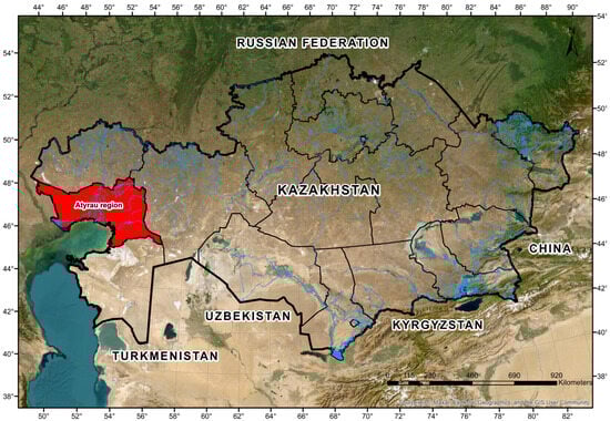
Figure 1.
Study area: Atyrau Region, Kazakhstan. Source: compiled by the authors based on data from ESRI, Maxar Technologies, Earthstar Geographics, and the GIS User Community.
The integrated assessment of pasture ecosystem degradation under the arid conditions of the Atyrau Region was based on five complementary methodological components, each of which reveals a specific aspect of the sustainability, vulnerability, and transformation of pasture resources.
The objective of the developed methodology is to conduct a comprehensive and quantitatively substantiated assessment of the condition of pasture ecosystems under the arid conditions of the Atyrau Region, taking into account the intensity of zootechnical load, the spatial distribution of grazing, the availability of pasture infrastructure, and the institutional orderliness of land use. The methodology aims to identify spatially localized degradation hotspots, analyzing factors of overload and institutional conflicts, as well as zoning areas according to the degree of anthropogenic impact for the subsequent development of recommendations on the sustainable management of pasture resources.
The cartographic basis of the study was formed on the digital platform “Geoinformation Support of Pastures of Kazakhstan,” developed by the Kazakh Research Institute of Livestock and Forage Production (2018) [41]. Thematic maps of pasture forage capacity, water availability, productivity, and classification of pasture types at a scale of 1:1,500,000 were used, as well as administrative boundaries of regions, districts, and rural districts. In ArcGIS 10.8, key characteristics of pasture lands were digitized: area, seasonality of use, average annual yield, dominant vegetation types, and the presence of water sources. This stage provided a spatial-analytical foundation for subsequent comparison with pasture load data.
Figure 2 illustrates the conceptual framework of the Anthropogenic Load (AL) Model, which integrates spatial, infrastructural, and institutional dimensions for the comprehensive assessment of pasture degradation in arid regions.

Figure 2.
Methodological framework of the Anthropogenic Load (AL) Model for integrated assessment of pasture degradation in arid regions. Source: Compiled by the authors.
3.1. Calculation of Pasture Load (PL)
The assessment of pasture load is the central stage in diagnosing the condition of pasture ecosystems in arid regions. In contexts where traditional livestock breeding serves not only as a key sector of agriculture but also as the main source of livelihood for the rural population, the analysis of the correspondence between livestock numbers and the potential of the pasture forage base becomes particularly relevant.
Pasture load was assessed as the quantitative ratio between the actual livestock population (in livestock units) and the forage capacity of the corresponding pastures. For the calculation of actual load, statistical data by districts and rural districts were used, including the number of livestock by species (cattle, small ruminants, horses, etc.). All types of livestock were converted into sheep livestock units according to commonly accepted coefficients. The permissible load was calculated based on the forage mass yield of pastures (in kg/ha), the duration of the grazing period, and the daily feed requirement of one livestock unit. The difference between the actual and the normatively permissible load enabled determination the degree of pasture overload for each rural district [42].
Pasture load (PL) is a quantitative indicator of the degree of exploitation of pasture resources and is defined as the ratio of the adjusted number of agricultural animals (converted into livestock units) to the area of utilized pasture lands [43]. It makes it possible to identify areas with sustainable, stressful, or critical levels of anthropogenic pressure on the ecosystem, as well as to predict threats of its degradation. The model expression is
where
—pasture load (LU/ha);
—total number of livestock units;
—area of utilized pastures, ha.
The conversion coefficients for livestock into sheep units were adopted from the official guidelines of the Ministry of Agriculture of Kazakhstan (2018), which are standardized for arid regions. Their applicability to the Atyrau Region was validated by local experts. A preliminary sensitivity analysis, varying coefficients by ±10%, indicated minimal impact on the district-level PL classification (<5%), confirming the robustness of the approach.
The conversion of the actual livestock population into livestock units (LU) performed using standard zootechnical equivalence coefficients, not based on live weight but on the coefficient value: sheep and goats = 1 sheep unit, cattle = 5 sheep units, horses = 6 sheep units, camels = 7 sheep units (Table 1).

Table 1.
Conversion coefficients of different types of livestock into livestock units (LU) for the calculation of pasture load.
The calculation of the total pasture load in each district or rural district was carried out according to the following formula [44]:
where is the number of livestock of the corresponding type.
The area of pasture lands accounted for both agricultural lands officially registered in the state land cadastre (according to data from akimats and the Land Committee of the Republic of Kazakhstan), and areas actually used for seasonal livestock grazing (identified through spatial analysis in ArcGIS 10.8 based on departmental maps and land use schemes).
For the analysis of the sustainability of pasture use, a regulatory-expert classification scale of pasture load was applied, adapted to the ecological and geographical conditions of the Atyrau Region (Table 2).
Table 2.
Classification of pasture load (PL) levels and their ecological interpretation.
The applied approach was used to obtain an objective and reproducible assessment of the degree of pasture utilization for each district and allowed inter-territorial comparisons. The results of pasture load calculations were visualized as thematic (choropleth) maps, which illustrated the spatial differentiation of anthropogenic pressure.
The calculations were carried out using 2023 statistical data aggregated by the eight districts of the Atyrau Region. All numerical indicators (livestock numbers and pasture areas) were verified for internal consistency and cross-checked with data from local akimats [45,46,47,48,49,50,51,52]. Particular attention was given to districts with limited pasture area and high livestock density, as even minor deviations in these cases may significantly affect the accuracy of the estimates. The pasture load calculation was applied as a quantitative basis for further analysis of degradation factors, cartographic zoning, and the formulation of recommendations for sustainable pasture management.
3.2. Limitations and Scope of the KDE Method
It should be noted that the Kernel Density Estimation (KDE) method has both strengths and limitations. KDE provides a smoothed visualization of livestock concentration and allows the identification of localized overload zones (“hot spots”), which makes it highly effective for detecting areas of increased anthropogenic pressure near settlements and water sources [53]. However, this method does not reflect actual pasture boundaries and is sensitive to the choice of bandwidth, which determines the degree of smoothing. Moreover, the accuracy of KDE depends on the quality and completeness of the input data, and it does not directly account for pasture productivity or vegetation biomass. In this study, KDE was applied as a diagnostic tool for spatial analysis of grazing unevenness, with the results serving as a basis for further ecological assessment and sustainable management planning.
3.3. Institutional Load Index ()
The Institutional Load Index () was constructed to capture the degree of institutional regulation of pasture use. is defined as the normalized sum of five binary parameters: (1) presence of lease agreements, (2) seasonal use, (3) rotation practice, (4) presence of access conflicts, and (5) cadastral registration. Each parameter was coded as 0 (regulation present) or 1 (regulation absent). The index is calculated as
where represents the binary score of parameter k in district i. Values of range between 0 (strong institutional regulation) and 1 (complete absence of regulation). The selection of parameters was based on established literature linking land tenure, governance, and rangeland sustainability [54,55]. This framework allows to serve as a proxy for institutional vulnerability in pasture management systems.
One of the critical drivers of pasture degradation is the institutional disorder of land use. To quantitatively capture the degree of formalization of access and regulation, the Institutional Load Index () was developed, normalized on a scale from 0 (complete institutional control) to 1 (complete absence of regulation). For interpretation, four descriptive ranges were introduced:
- –
- 0.00–0.25 (low institutional load): lease agreements are in place, pastures are registered in the cadaster, and seasonal rotation is applied consistently.
- –
- 0.26–0.50 (moderate institutional load): land is formally leased but pasture rotation is only partially implemented; seasonal schedules are occasionally violated; isolated access conflicts are recorded.
- –
- 0.51–0.75 (high institutional load): pastures are only partially leased and cadastral registration is incomplete; spontaneous grazing is widespread; recurrent conflicts between private households and lessees are observed.
- –
- 0.76–1.00 (critical institutional load): no lease or cadastral registration; spontaneous, unregulated grazing dominates without seasonality or rotation; conflicts and degradation risks are systemic.
The calculation of Ii was based on the analysis of five parameters: (1) presence of lease agreements; (2) seasonality of use; (3) presence of pasture rotation practices; (4) occurrence of access conflicts (private household plots versus lessees); and (5) official registration of pastures in the cadaster. Each parameter was coded in a binary manner (1 = absence of regulation, 0 = presence of regulation), and the aggregated index was derived as the normalized sum of violations across all parameters.
3.4. Integral Model of Anthropogenic Load on Pasture Ecosystems
Assessment of the degree of anthropogenic impact on pasture ecosystems requires going beyond simple numerical registration of livestock numbers and covering a broader range of factors influencing spatial stability and degradation processes in the landscape shell. For this purpose, within the framework of the present study, an integral model of anthropogenic load (AL) was developed, representing a multi-component index reflecting the spatial-ecological intensity of pastureland exploitation [56,57,58].
This model is based on the premise that anthropogenic pressure is the result of the combined effect of not only operational (quantitative) indicators but also spatial, institutional, and infrastructural characteristics that determine the intensity, localization, and legal regulation of pasture use.
Spatial density () was calculated using Kernel Density Estimation with a fixed radius of 5 km, reflecting the average livestock grazing distance from water sources and settlements.
Accessibility index () was defined as an inverse-distance function ( = 1/d), with values normalized to the range [0;1]. Beyond the 5 km buffer zone, accessibility was considered negligible.
Institutional load index () was calculated as the normalized sum of five binary parameters (lease agreements, seasonality, rotation, conflict presence, cadaster registration), with the final value ranging between 0 (full regulation) and 1 (absence of regulation).
The conceptual model is based on the following integrative equation [59,60]:
—generalized index of anthropogenic load on pasture cell;
—level of pasture load (LU/ha), reflecting the ratio between livestock units and the area of used pastures;
—spatial density of livestock distribution, expressed through the smoothed density value (Kernel Density) within a given radius;
—accessibility index, calculated as a function of the inverse distance from the center of the cell to the nearest water source, road, or pasture camp, taking into account a 5 km buffer zone;
—institutional coefficient, reflecting the degree of legal regulation and governability of land use (lease agreements, presence of seasonal pasture rotation, presence of access conflict);
α, β, γ, δ—weighting coefficients reflecting the relative significance of each component in the load structure.
For the integral assessment of anthropogenic load (AL) on pasture ecosystems, weighting coefficients α, β, γ, and δ were used, reflecting the relative contribution of each component (pasture load, spatial density, infrastructural accessibility, institutional index) to the overall load level.
To determine the weighting coefficients (α, β, γ, δ), we applied the Analytic Hierarchy Process (AHP). A pairwise comparison matrix was constructed for the four components (pasture load, spatial density, infrastructural accessibility, institutional index) based on expert judgments of specialists in rangeland ecology and regional planning (n = 12). The normalized principal eigenvector of the comparison matrix yielded the relative weights of the indicators, while the consistency ratio (CR) was calculated to verify the reliability of expert judgments (CR < 0.1). As a result, the coefficients were established as follows: α = 0.35, β = 0.25, γ = 0.20, δ = 0.20.
The weighting coefficients (α, β, γ, δ) were derived using the Analytic Hierarchy Process (AHP) based on expert pairwise comparisons (n = 12). The consistency ratio was below the acceptable threshold (CR < 0.1), ensuring the reliability of expert judgments. The classification thresholds of the Pasture Load Index (PL) were adapted to the ecological and geographical conditions of the Atyrau region through expert consultations. It should be noted that the present assessment is based on statistical data for 2023, providing a snapshot rather than a multi-temporal trend.
The final component of the analysis was the assessment of organizational and legal conditions of pasture use. Forms of ownership (state, leased, communal), lease conditions, seasonality of access (summer and winter pastures), as well as the presence or absence of pasture rotation were analyzed. It was identified that a substantial portion of pastures within settlements (about 20 million ha nationwide) lacks a secure usage regime, leading to their spontaneous and excessive use. It was also established that reserve lands and remote pastures (over 50 million ha) remain poorly accessible due to lack of infrastructure, despite their high forage potential. It was found that degradation processes intensify under conditions of absence of a legal mechanism regulating access to pastures, weak coordination between lessees, local administrations, and government bodies.
4. Results
The implementation of the integrated methodology for assessing anthropogenic load on pasture ecosystems in the Atyrau region allowed obtaining a comprehensive picture of the spatial-functional state of the region’s pasture fund. Based on a multi-component analysis, including calculation of pasture load (PL), spatial livestock density (Kernel Density), assessment of infrastructural accessibility (Accessibility Index), and institutional usage regime (Institutional Index), a typology of degradation pressure was formed, taking into account both quantitative and structural parameters of pastureland exploitation.
The analysis of the spatial structure of pasture lands revealed a pronounced territorial differentiation within the Atyrau region (Figure 3).
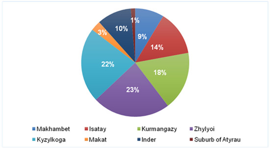
Figure 3.
Structure of pasture land distribution by districts of the Atyrau region. Source: compiled by the authors based on land use analysis and data from the Atyrau Regional Department of Agriculture for 2023.
The largest share of pasture resources is concentrated in the Zhylyoi (23%) and Kyzylkoga (22%) districts, which is explained by the extensive territory and low population density. A significant proportion of pastures is also recorded in the Kurmangazy district (18%), where livestock farming is actively developing along the Ural River valley and near border zones. In the Makhambet (9%), Isatay (14%), and Inder (10%) districts, the share of pastures is moderate, ranging from 9 to 14%, which is associated with more intensive agricultural development and competition for land resources from irrigated areas and arable lands. The smallest share of pastures is observed in the suburb of Atyrau (1%) and in the Makat district (3%), where large areas are occupied by industrial infrastructure, oil fields, and urbanized territories.
4.1. Results of Spatial Analysis of Pasture Load in the Atyrau Region
For the quantitative assessment of anthropogenic pressure on pasture lands in the Atyrau region, the Pasture Load Index (PLi) was calculated based on the integration of data on the number of agricultural animals converted to livestock units and the indicators of pasture forage capacity at the level of rural districts. Agricultural statistics data were aggregated at the district level with subsequent calculation of the weighted average PLi, which allowed obtaining a picture of the spatial differentiation of pressure on natural pasture resources [61].
Methodologically, the PLi represents the ratio between the livestock’s demand for forage resources (calculated per livestock unit) and the potential pasture production (in centners per hectare per year). PLi > 1 indicates exceeding the permissible load, whereas PLi < 1 indicates a reserve in forage capacity.
The analysis results showed significant differences in PLi values among the districts of the Atyrau region. The most critical situation was recorded in the Kurmangazy district, where the index reached 3.35, more than three times exceeding the ecologically permissible load. Similar values were registered in the Inder district (1.64), as well as in the suburb of Atyrau (1.24), which also corresponds to the category of pasture overload. In these districts, a high concentration of livestock is observed against the background of limited accessibility to pastures and water sources, as well as weak territorial diversification of grazing systems.
The average PLi value in the Zhylyoi district was 0.94, approaching the threshold value and indicating a trend toward increased load. This zone can be characterized as transitional, where without additional management decisions, a shift toward degradation processes may occur.
In several districts (Isatay—0.35, Kyzylkoga—0.30, Makat—0.20), a relatively favorable pasture situation is observed, where the livestock forage demand does not exceed the productive capacity of the pastures. However, a low PLi in these districts does not necessarily indicate sustainability—it may also reflect underutilization of potential due to low livestock numbers, limited transport and water accessibility of the lands, or population migration.
Livestock numbers in the Makat district are characterized by relatively low values, which allows classifying the territory among regions with moderate pasture load. At the same time, the district is located in an active oil production zone, which causes substantial technogenic impact on the natural environment. Moreover, the predominance of saline soils and unfavorable agroecological conditions significantly limit the possibilities for livestock development, reducing the forage capacity of lands and increasing the risk of degradation of pasture ecosystems.
The obtained results confirm the presence of spatial inequality in the distribution of pasture load, which, in turn, is caused by a combination of natural, infrastructural, and socioeconomic factors. High PLi values are predominantly recorded in arid and semi-desert areas with limited water sources, which intensifies degradation processes. Furthermore, irrational seasonal redistribution of pastures, absence of rotational systems, and ineffective institutional regulation also contribute to the local concentration of overload.
For a clearer visualization of the results, a thematic map was created classifying districts by degrees of pasture load (Figure 4).

Figure 4.
Spatial differentiation of pasture load in the Atyrau region: 1—Kurmangazy district; 2—Isatay district; 3—Inder district; 4—Makhambet district; 5—Kyzylkoga district; 6—Makat district; 7—Zhylyoi district; 8—suburb of Atyrau. Source: compiled by the authors based on the calculations of the Pasture Load Index (PLI) and data from the Atyrau Regional Department of Agriculture, 2023.
The following classes are distinguished: underload (PLi < 0.8)—favorable zones with potential for sustainable livestock increase; moderate load (0.8–1.0)—zones with permissible use; overload (1.0–1.5)—risk zones requiring adaptive management; critical load (>1.5)—zones with a high probability of pasture degradation where urgent measures are needed (grazing restrictions, vegetation cover restoration, artificial irrigation, etc.).
The spatial differentiation of total livestock numbers and their species composition is presented in Figure 5 and Figure 6.
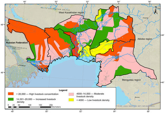
Figure 5.
Spatial distribution of livestock in the Atyrau region. Source: compiled by the authors based on data from the Atyrau Regional Department of Agriculture.
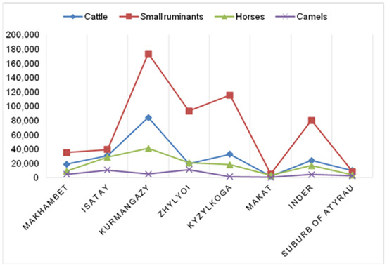
Figure 6.
Distribution of the main livestock species by districts of the Atyrau region. Source: compiled by the authors based on data from the Atyrau Regional Department of Agriculture.
Additional analysis revealed that the levels of pasture load (PLi) are closely linked to the species composition of livestock. Districts with a predominance of small ruminants (sheep and goats) show the highest PLi values, reflecting the stronger pressure exerted on vegetation cover due to selective grazing. In contrast, territories with a higher share of cattle demonstrate relatively lower stress per livestock unit, while the presence of horses and camels leads to a more spatially dispersed use of pastures. This relationship highlights the importance of considering not only the total number of animals but also their structural composition when developing management recommendations.
The classification is based on the aggregation of all livestock species (cattle, small ruminants, horses, camels). The most pronounced zones of high and elevated livestock density are associated with rural districts located along the valleys of the Ural, Oyil, and Zhem rivers, as well as areas with residual irrigation infrastructure. These zones are characterized by intensive agricultural exploitation and high anthropogenic pressure on pasture lands. In the southern and southeastern parts of the region, areas with low livestock density prevail, which may be due to both limited accessibility to water resources and the degradation of the forage base because of aridization.
4.2. Spatial Concentration of Anthropogenic Pressure: Overload Zones and “Hotspots”
To identify localized hotspots of excessive pasture load under arid conditions in the Atyrau region, the method of spatial livestock density estimation (Kernel Density Estimation, KDE) was applied, based on constructing a smoothed density surface within a specified search radius (5 km). The use of this method in ArcGIS 10.8 made it possible to determine areas with the highest concentration of livestock units by comparing them with parameters of accessibility, infrastructural coverage, and forage productivity of pasture lands.
The next stage involved analyzing the spatial imbalance between livestock distribution and the potential productivity of pastures. For this purpose, spatial analysis tools were employed, including layer intersection, kernel density estimation of livestock distribution, buffering of 5 km zones around water points, and hotspot analysis to identify areas of maximum overload. The results showed that, in most cases, livestock was concentrated within 3–5 km of water sources, leading to localized resource depletion, while remote pastures remained underutilized.
The analysis showed that in the territory of most rural districts (in particular, Birlik, Kudryashov, Bukeykhan, Shortanbai, Koptogai, and others), there is a pronounced spatial polarization of pasture load (Figure 7).

Figure 7.
Spatial distribution of “hotspot” areas of pasture load and 5 km buffer zones in the Atyrau region. Source: compiled by the authors based on geospatial analysis of pasture pressure, using satellite imagery and infrastructure layers.
The formation of “hotspots” occurs predominantly within a radius of 5 km from permanent or temporary water sources (wells, boreholes, irrigation canals) and pasture camps. These areas are characterized by: high grazing intensity per unit area (>5 LU/ha locally), absence of pasture rotation, significant anthropogenic transformation of the vegetation cover (trampling, depletion of forage species), disruption of phytocoenotic mosaic structure, and displacement of valuable pasture formations.
In contrast, remote areas of pastures (located 7–15 km or more from infrastructure nodes) within the same districts remain practically unused. Spatial comparison of the livestock density map with the map of potential pasture productivity (based on thematic data from the Kazakh Research Institute of Animal Husbandry) revealed a high level of mismatch: on average, from 38% to 45% of the pasture forage capacity remains outside of economic use due to: lack of transport accessibility (absence of roads, bridges, access routes), shortage of water sources and infrastructure for livestock maintenance in remote areas, the informal nature of land use, and absence of secured grazing routes.
This circumstance indicates a systemic spatial imbalance between the actual load and resource capacity, leading to local overload in zones of intensive grazing and inefficient use of the overall pasture fund. Such imbalance is further aggravated by seasonal factors—during the summer period, overload of “hotspots” is especially pronounced due to dependence on water, while in winter, the situation shifts towards areas located near settlements.
The KDE methodology and comparative spatial analysis make it possible not only to quantitatively identify zones of pressure redistribution but also to substantiate the transition to a spatially adaptive pasture management system. This includes decentralization of water supply, restoration of pasture infrastructure, expansion of accessible areas through the establishment of temporary standing points, as well as the introduction of digital grazing control at the level of rural districts.
4.3. Institutional Fragmentation and Access Conflicts over Pasture Resources
The study of the institutional component of pastureland uses under the arid conditions of the Atyrau region revealed a critical level of structural instability and fragmentation of pasture management mechanisms. The analysis of materials from local administrations, land cadaster data, and interviews with key stakeholders (representatives of leaseholders, rural districts, and private household plots) established that more than 60–65% of utilized pastures (mainly reserve lands and pastures within settlement boundaries) are exploited under informal or spontaneous access regimes. These areas are not covered by lease agreements, are not included in rotational schemes, lack spatial restrictions, and are subject to multiple, uncoordinated use.
Particularly pronounced institutional fragmentation is observed in certain rural districts of the Kurmangazy, Isatay, Makhambet, Inder, and Kyzylkoga districts, where high rural population density and significant livestock numbers are combined with the absence of clearly defined and secured boundaries of pastureland use. Under these conditions, several parallel and poorly coordinated management regimes operate: agricultural land leaseholders who obtained land through competitive procedures; private household plot owners (PHP), who practice spontaneous and uncontrolled grazing near settlements; and extensive “no-man’s” zones exploited based on spatial accessibility without formal allocation to specific legal entities.
Such institutional fragmentation complicates effective management of pasture resources, increases conflict potential, and contributes to ecosystem degradation.
As a result, conflict configurations of pasture use are formed, characterized by: competition for limited pasturelands between leaseholders and local residents; non-compliance with inter-seasonal or rotational grazing regimes (due to their absence); high probability of overuse, local depletion, and overgrowth with weeds and inedible species.
For the quantitative assessment of the degree of institutional pressure, the Institutional Load Index (Ii) was used, calculated as a normalized value on a [0–1] scale, where 0 indicates full regulation (lease agreements, pasture rotation schedules, cadastral registration), and 1 indicates a complete absence of institutional control (spontaneous and unsecured grazing). In districts with high population density and mixed forms of land use, Ii reaches values from 0.75 to 0.88, indicating an extremely low level of formalization.
For the spatial analysis of the level of formalization and governability of pastureland use, all rural districts were classified based on the value of the Institutional Load Index (Ii), normalized within the range [0–1] (Figure 8).

Figure 8.
Cartogram of institutional load (Ii) in rural districts of the Atyrau region. Source: compiled by the authors.
According to the Institutional Load Index (Ii), a clear differentiation of districts was revealed across four categories of institutional load. Districts with critical load (Ii > 0.8) were characterized by the absence of formal lease agreements, spontaneous grazing, and the lack of pasture rotation. This group included Zhylyoi, Makat, and Kyzylkoga districts. Areas with a high load (0.6 < Ii ≤ 0.8) demonstrated fragmented management practices and a partial lack of regulation, such as Kulsary, Birlik, Almaly, and Zhana Karaton. Districts classified as having a moderate load (0.4 < Ii ≤ 0.6) showed partial elements of institutional regulation but suffered from insufficient infrastructure and incomplete cadastral coverage; these included the suburbs of Atyrau, Teniz, Safon, Shortanbai, Koptogai, and Zhanbay. Finally, districts with a low load (Ii ≤ 0.4), such as Zhanatalap, Bokeykhan, Kudryash, and Nurzhau, exhibited a relatively stable institutional regime with functioning lease agreements, cadastral registration, and partial or full seasonal rotation.
The spatial comparison of the Institutional Load Index (Ii) with the actual pasture load level (PL) allowed for the recognition of zones subject to institutional overload, where high values of both indicators coincide. It is precisely in these zones (Kurmangazy district, the southern part of Inder district, and Makhambet district) that persistent degradation hotspots are forming, combining ecological-resource and management vulnerabilities. These results highlight the urgent need for institutional intervention: the introduction of zoning mechanisms, formal lease agreements, digital grazing monitoring, and pasture regulation systems at the rural district level.
The institutional vacuum in pasture management exacerbates degradation trends and creates preconditions for conflicts among land use stakeholders. Without a comprehensive policy of institutionalizing pasture turnover, the sustainable use of natural resources in arid regions is impossible.
4.4. Integrated Assessment of Anthropogenic Load and Geographical Zoning of Degradation Risks
The final stage of the integrated analysis of the pasture ecosystem conditions in the Atyrau region involved the synthesis of quantitative, spatial, infrastructural, and institutional data within the framework of the integrated anthropogenic load (AL) assessment model. For each conditional spatial cell with a size of 5 × 5 km, a generalized value of the AL index was calculated, allowing for characterization of the degree of ecological-resource and management overload. The methodology was based on the preliminary normalization of component indicators (pasture load, livestock density, accessibility index, and institutional coefficient), followed by the assignment of weights reflecting their contribution to the overall load.
The aggregated results of spatial modeling showed that the territory of the Atyrau region demonstrates a pronounced mosaic structure, alternating between areas with stable and critically overloaded pasture use regimes. Based on cluster analysis and expert classification, three functional–ecological categories were identified, differing in the degree of anthropogenic transformation and degradation risk (Figure 9).
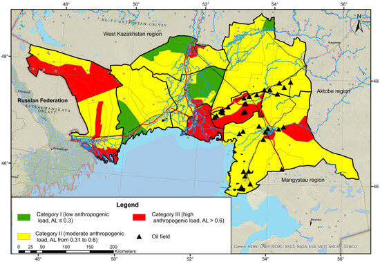
Figure 9.
Spatial distribution of anthropogenic load levels on pasture ecosystems in the Atyrau region. Source: compiled by the authors.
Low load, AL ≤ 0.3 (I)—primarily covers remote areas characterized by a balanced livestock population, well-developed seasonal rotation, and institutionally secured usage schemes. These pastures show no signs of overload, demonstrate stable recovery of phytomass after grazing, and infrastructural limitations are compensated by low livestock density.
Moderate load, AL from 0.31 to 0.6 (II)—includes areas with limited water availability, intermittent rotation, and localized access conflicts. Initial degradation hotspots are observed here: decreased forage productivity, trampling, and displacement of valuable species. The load pressure is moderate; however, there is increasing stress, especially near wells and along transport corridors.
High load, AL > 0.6 (III) constitutes critically vulnerable areas where four degradation factors combine: exceeding permissible pasture load, spatial hyper-concentration of livestock, remoteness from water sources, and absence of legal regulation of land use. These areas are identified near settlements (Atyrau, Inder, Kyzylkoga), where pasture rotation is absent, and the pressure on pastures reaches critical levels. These zones experience vegetation cover exhaustion, formation of persistent erosion hotspots, overgrowth with inedible species, and a sharp decline in biodiversity.
The zoning results provide not only diagnostic information but also a spatial foundation for developing priority sustainable management measures. Specifically, for category III areas, it is recommended to implement pasture restoration programs, water supply to remote areas, creation of micro-water sources, redistribution of grazing, as well as digital registration of users and GIS-based monitoring. For category II, relevant measures include institutionalizing access and developing mobile infrastructure, while category I requires only systematic observation and prevention of excessive load.
5. Discussion
This study has theoretical significance as it is the first to integrate three key dimensions of degradation processes in the context of Kazakhstan’s arid ecosystems: anthropogenic load (livestock density), infrastructural accessibility, and institutional fragmentation of land tenure systems. The scientific novelty lies in the development and testing of the multifactor AL model, which enables the quantitative incorporation of institutional factors, an aspect that has been largely overlooked in previous research. Furthermore, the use of GIS-based approaches (Kernel Density Estimation, accessibility indices) provides the opportunity for spatial validation of the obtained results and guarantees the model’s reproducibility in other arid regions of Central Asia.
The study has several limitations. First, the temporal scope of the analysis is restricted to a single year (2023), which reduces the ability to identify long-term trends of degradation. Second, the model relies on livestock statistics and satellite imagery, both of which are subject to errors and assumptions (for instance, informal grazing or seasonal livestock migration is not always reflected in official records). Third, the institutional parameters (land use orderliness index) are based on secondary data and expert assessments, which may introduce a degree of subjectivity. Finally, the proposed model requires further validation through an expanded geographical and temporal coverage, as well as adaptation for practical application in state-level planning.
In the discussion of the identified pasture hotspots, it is essential to emphasize that the revealed underutilization of 38–45% of forage capacity reflects not only ecological and logistical constraints but also institutional and historical legacies. The prevailing scheme of highly centralized “circular grazing around wells” results in both the overexploitation of localized areas and the simultaneous neglect of distant, high-quality rangelands. This spatial asymmetry suggests the persistence of a path dependency effect: the transition from nomadic and semi-nomadic pastoralism to a sedentary and more intensive form of livestock management in the post-Soviet era has locked the system into suboptimal spatial practices. Furthermore, this situation can be interpreted as an institutional failure, where existing regulatory and organizational mechanisms do not provide adequate incentives for the rational redistribution of grazing pressure. Consequently, the observed mismatch between ecological potential and actual land use highlights the need to strengthen institutional frameworks for pasture governance, including mechanisms of rotational grazing, community-based management, and the diversification of water and transport infrastructure.
The underutilization of 38–45% of forage capacity due to poor accessibility and water scarcity reflects a structural imbalance in pasture use. Addressing this requires not only infrastructure investments but also specific measures such as decentralized watering points, improved feeder roads, and institutional support for rotational grazing and cooperative management.
The results of the integrated assessment of anthropogenic load on pasture ecosystems in the Atyrau region clearly demonstrated the complex and multidimensional nature of degradation processes shaped by arid climatic conditions and the socio-economic transformation of rural land use. Despite the substantial size of the pasture fund, the spatial distribution of load was found to be highly uneven: in several districts, there is a persistent trend of hyper-concentration of livestock in near-settlement and water-accessible areas, accompanied by phytocenosis depletion, formation of dust hotspots, and soil humus depletion.
The conducted territorial classification based on the integrated AL index made it possible to identify three consistently distinct types of pasture exploitation. Pasture areas of category I, where actual load, land productivity, and seasonal grazing rhythms align, occupy less than 30% of the entire study area. Most districts are characterized by a permanent transition to risk zones (category II), where pasture potential remains but signs of ecosystem imbalance are already evident. The most alarming situation is observed in the critical load zones (category III), predominantly in rural districts of Inder, Kyzylkoga, and the suburban belt of Atyrau, where spatial overload, high livestock density, absence of rotation, and institutional disorder of access converge.
Particular attention within the discussion deserves the identified institutional fragmentation of pastureland use. Up to 65% of used land is exploited outside legal frameworks—without lease agreements, secured boundaries, or regulated schedules. This not only hampers the implementation of sustainable management practices (e.g., pasture rotation) but also generates conflict interactions between leaseholders and private household plots, as confirmed by the high value of the institutional index (Ii > 0.8) in several districts. Similar institutional crises are observed in other countries of the arid belt—Mongolia, Iran, Morocco—where the absence of regulation over traditional grazing exacerbates ecosystem instability [62,63].
Integrated cartographic zoning allows for the clear localization of pasture stress hotspots and the structuring of space according to risk and resilience levels, creating a basis for targeted sustainable land use policies in arid regions.
Spatial analysis based on KDE and hotspot modeling made it possible not only to map overload hotspots but also to identify structural gaps in pasture water supply infrastructure. Approximately 38–45% of productive lands remain underutilized due to their remoteness from water points and livestock camps. This highlights the need for the reinfrastructure of pasture areas, including the installation of wells, restoration of water-lifting mechanisms, and optimization of seasonal grazing route logistics.
The summarized research results demonstrate that pasture degradation processes in the Atyrau region are shaped by the intersection of four factors: biophysical (resource limitations in arid zones); spatial (load localization); demographic (increasing livestock numbers while maintaining traditional grazing systems); and institutional (legal vacuum in land use management).
Preventing pasture degradation requires a systemic approach that combines spatial planning, institutional reforms, justified livestock regulation, and the restoration of degraded lands. The developed anthropogenic load model can be adapted for other regions of Kazakhstan and Central Asia as a diagnostic tool for spatial monitoring and a foundation for sustainability-oriented pasture policy.
Compared to previous studies that mostly relied on descriptive surveys or localized assessments of grazing pressure, our AL model demonstrates higher reproducibility by integrating livestock density, accessibility, and institutional fragmentation into a unified geospatial framework. This not only overcomes the limitations of fragmented local analyses but also provides a quantifiable indicator of institutional effects on pasture degradation. The model’s transferability across arid regions of Central Asia makes it applicable for environmental monitoring systems and regional land use planning initiatives.
6. Conclusions
The integrated assessment of pasture load under the arid conditions of the Atyrau region revealed pronounced territorial differences in the degree of anthropogenic pressure on ecosystems, determined not only by livestock numbers but also by the spatial accessibility of pastures, water availability, and the institutional organization of land use. The obtained results allow for the following applied and strategically oriented conclusions:
The most overloaded areas are localized within a radius of 3–5 km from water sources, where “hotspots” of redistributed load are observed. This necessitates the implementation of spatial load redistribution programs and incentives for the use of remote pastures.
High values of the Ii index (up to 0.88) in several districts indicate the absence of legal regulation mechanisms and rotational use. A priority task is the development and implementation of a legally established scheme of pasture rotation and a user rights accounting system.
Up to 40% of productive pastures remain unutilized due to infrastructural inaccessibility, indicating the need for investments in the development of transport and water infrastructure and a network of watering points.
Cartographic division of the territory into three categories (sustainable, stressed, critically overloaded zones) forms the basis for a targeted approach to pasture management: from enhanced monitoring and regulation in category III zones to support programs in category I–II zones.
The proposed methodology enabled a comprehensive assessment of the multidimensional structure of anthropogenic pressure and facilitated the identification of priority risk zones. This provided a scientific foundation for spatially oriented management of pasture resources in climatically vulnerable territories. The obtained results demonstrate the practical applicability of the model: they can be employed in the development of regional sustainable land use strategies, in pasture monitoring programs, and in geoecological zoning initiatives.
The proposed anthropogenic load model is reproducible and scalable for other regions of Kazakhstan and Central Asia with similar arid conditions. It can be integrated into environmental monitoring systems, cadastral planning, and sustainable rural development programs.
Author Contributions
Conceptualization, K.A. and M.M.; methodology, K.A. and M.M.; software, K.S. and D.I.; validation, A.S. and R.I.; formal analysis, K.S., A.S. and R.I.; investigation, K.A., N.S., M.M., K.S., A.S., R.I., A.T. and D.I.; writing—original draft preparation, M.M., K.S. and A.S.; writing—review and editing, K.A., N.S. and R.I.; supervision, R.I.; visualization, A.S., A.T. and D.I.; project administration, K.S. and R.I. All authors have read and agreed to the published version of the manuscript.
Funding
This research was supported by the Science Committee of the Ministry of Science and Higher Education of the Republic of Kazakhstan under the program-targeted funding project (PCF) IRN: BR21882122, titled: “Sustainable development of natural-economic and socio-economic systems of the West Kazakhstan region in the context of green growth: complex analysis, concept, forecast estimates and scenarios”.
Data Availability Statement
The data presented in this study are available in this article.
Conflicts of Interest
The authors declare no conflicts of interest.
References
- Nasiyev, B.; Karynbayev, A.; Khiyasov, M.; Bekkaliyev, A.; Zhanatalapov, N.; Begeyeva, M.; Bekkaliyeva, A.; Shibaikin, V. Influence of cattle grazing methods on changes in vegetation cover and productivity of pasture lands in the semi-desert zone of western Kazakhstan. Int. J. Des. Nat. Ecodynamics 2023, 18, 767–774. [Google Scholar] [CrossRef]
- Wei, W.; Zhu, Y.; Li, H.; Zhang, K.; Wang, B.; Yang, X.; Shi, Z. Spatio-Temporal Reorganization of Cropland Development in Central Asia during the Post-Soviet Era: A Sustainable Implication in Kazakhstan. Sustainability 2018, 10, 4042. [Google Scholar] [CrossRef]
- Alimaev, I.I.; Skorintseva, I.B.; Basova, T.A.; Krylova, V.S. Sustainable Management of Kazakhstan’s Pasture Resources Using GIS Technologies. Geogr. Water Resour. 2017, 2, 64–74. [Google Scholar]
- Agency of the Republic of Kazakhstan on Statistics. Agriculture, Forestry, and Fisheries of Kazakhstan in 2024: Statistical Yearbook; Agency of the Republic of Kazakhstan on Statistics: Astana, Kazakhstan, 2025. [Google Scholar]
- Robinson, S.; Milner-Gulland, E.J.; Alimaev, I. Rangeland degradation in Kazakhstan during the Soviet era: Re-examining the evidence. J. Arid Environ. 2003, 53, 419–439. [Google Scholar] [CrossRef]
- Mirzabaev, A.; Ahmed, M.; Werner, J.; Pender, J.; Louhaichi, M. Rangelands of Central Asia: Challenges and opportunities. J. Arid Land 2016, 8, 93–108. [Google Scholar] [CrossRef]
- Tokbergenova, A.; Skorintseva, I.; Ryskeldiyeva, A.; Kaliyeva, D.; Salmurzauly, R.; Mussagaliyeva, A. Assessment of Anthropogenic Disturbances of Landscapes: West Kazakhstan Region. Sustainability 2025, 17, 573. [Google Scholar] [CrossRef]
- Ongayev, M.; Denizbayev, S.; Umbetkaliyev, N.; Yesmagulova, B.; Shadyarov, T.; Ozhanov, G. The zonality of underground water supply sources for pastures in the West Kazakhstan region. J. Ecol. Eng. 2022, 23, 56–65. [Google Scholar] [CrossRef]
- Robinson, S.; Jamsranjav, C.; Gillin, K. Pastoral property rights in Central Asia—Factors and actors driving the reform agenda. Études Rural. 2017, 200, 220–253. [Google Scholar] [CrossRef]
- Kerven, C.; Robinson, S.; Behnke, R. Pastoralism at scale on the Kazakh rangelands: From clans to workers to ranchers. Front. Sustain. Food Syst. 2021, 4, 590401. [Google Scholar] [CrossRef]
- Tomaszewska, M.A.; Henebry, G.M. Remote Sensing of Pasture Degradation in the Highlands of the Kyrgyz Republic: Finer-Scale Analysis Reveals Complicating Factors. Remote Sens. 2021, 13, 3449. [Google Scholar] [CrossRef]
- Zhu, S.; Chen, X.; Zhang, C.; Fang, X.; Cao, L. Carbon variation of dry grasslands in Central Asia in response to climate controls and grazing appropriation. Environ. Sci. Pollut. Res. 2022, 29, 32205–32219. [Google Scholar] [CrossRef] [PubMed]
- Alimaev, I.I.; Krylova, V.S. Digital model of pasture resource managementin practical application. Issues Geogr. Geoecol. 2019, 1, 76–82. Available online: https://cyberleninka.ru/article/n/tsifrovaya-model-upravleniya-pastbischnymi-resursami-v-prakticheskom-primenenii (accessed on 5 April 2025).
- Reynolds, A.Q.; Derner, J.D.; Augustine, D.J.; Porensky, L.M.; Wilmer, H.; Jorns, T.; Briske, D.D.; Scasta, J.D.; Fernández-Giménez, M.E. Ecological sites: Can they be managed to promote livestock production? Rangelands 2019, 41, 239–243. [Google Scholar] [CrossRef]
- Safriel, U. Land Degradation Neutrality (LDN) in drylands and beyond–where has it come from and where does it go. Silva Fenn. 2017, 51, 1650. [Google Scholar] [CrossRef]
- United Nations Convention to Combat Desertification. Global Land Outlook 2nd Edition. Available online: https://www.unccd.int/resources/global-land-outlook/global-land-outlook-2nd-edition (accessed on 16 July 2025).
- Asner, G.P.; Elmore, A.J.; Olander, L.P.; Martin, R.E.; Harris, A.T. Grazing systems, ecosystem responses, and global change. Annu. Rev. Environ. Resour. 2004, 29, 261–299. [Google Scholar] [CrossRef]
- Herrick, J.E.; Shaver, P.; Pyke, D.A.; Pellant, M.; Toledo, D.; Lepak, N. A strategy for defining the reference for land health and degradation assessments. Ecol. Indic. 2019, 97, 225–230. [Google Scholar] [CrossRef]
- Kussainova, M.; Spaeth, K.E.; Zhaparkulova, E. Efficiency of using the rangeland hydrology and erosion model for assessing the degradation of pastures and forage lands in Aydarly, Kazakhstan. Eurasian J. Soil Sci. 2020, 9, 186–193. [Google Scholar] [CrossRef][Green Version]
- Pashkov, S.V.; Sergeyeva, A.M. Diversification of cropping structure as a way to intensify agriculture in old developed areas of Kazakhstan. Proc. Tula States Univ.-Sci. Eart 2025, 1, 140–150. [Google Scholar][Green Version]
- Plokhikh, R.; Shokparova, D.; Fodor, G.; Berghauer, S.; Tóth, A.; Suymukhanov, U.; Zhakupova, A.; Varga, I.; Zhu, K.; Dávid, L. Towards Sustainable Pasture Agrolandscapes: A Landscape-Ecological-Indicative Approach to Environmental Audits and Impact Assessments. Sustainability 2023, 15, 6913. [Google Scholar] [CrossRef]
- Hämäläinen, E.; Krigsholm, P. Exploring the Strategy Goals and Strategy Drivers of National Mapping, Cadastral, and Land Registry Authorities. ISPRS Int. J. Geo-Inf. 2022, 11, 164. [Google Scholar] [CrossRef]
- Steudler, D.; Williamson, I.P. Evaluation of national land administration system in Switzerland. Surv. Rev. 2005, 38, 317–330. [Google Scholar] [CrossRef]
- Matuk, O.; Calka, B. Consolidating the Polish Land Use Cadastral Register with the Austrian and German Systems: An Extension of the Polish Cadastre Model Towards Sustainable Land Management. Sustainability 2025, 17, 5783. [Google Scholar] [CrossRef]
- Kreutzmann, H. Pastoralism in Central Asian mountain regions. In Pastoralism and Rangeland Management in Mountain Areas in the Context of Climate and Global Change; Kreutzmann, H., Abdulalishoev, K., Zhao, L.H., Eds.; Jürgen Richter Deutsche Gesellschaft für Internationale Zusammenarbeit (GIZ) GmbH: Feldafing, Germany, 2011; pp. 38–64. [Google Scholar]
- Fernandez-Gimenez, M.E. Spatial and social boundaries and the paradox of pastoral land tenure: A case study from postsocialist Mongolia. Hum. Ecol. 2002, 30, 49–78. [Google Scholar] [CrossRef]
- Li, W.; Huntsinger, L. China’s grassland contract policy and its impacts on herder ability to benefit in Inner Mongolia: Tragic feedbacks. Ecol. Soc. 2011, 16, 1–14. Available online: https://www.jstor.org/stable/26268879?seq=7 (accessed on 18 May 2025). [CrossRef]
- Turner, M.D.; Ayantunde, A.A.; Patterson, K.P.; Patterson, E.D. Livelihood transitions and the changing nature of farmer–herder conflict in Sahelian West Africa. J. Dev. Stud. 2011, 47, 183–206. [Google Scholar] [CrossRef] [PubMed]
- Archer, S.; Stokes, C. Stress, disturbance and change in rangeland ecosystems. In Rangeland Desertification; Arnalds, O., Archer, S., Eds.; Kluwer Publishing Company: Dordrecht, The Netherlands, 2000; pp. 17–38. [Google Scholar]
- Angerer, J.; Han, G.; Fujisaki, I.; Havstad, K. Climate change and ecosystems of Asia with emphasis on Inner Mongolia and Mongolia. Rangelands 2008, 30, 46–51. [Google Scholar] [CrossRef][Green Version]
- Kazakh Research Institute of Livestock and Fodder Production. Methodological Recommendations for Assessing the Condition of Pasture Lands and Determining the Permissible Pasture Load, 2018. Available online: https://www.kazniizhik.kz/ru/materialy (accessed on 15 July 2025).[Green Version]
- Torekhanov, A.A.; Alimaev, I.I.; Zhazylbekov, N.A.; Tadzhiyev, K.P. Scientific and Methodological Guidelines on the Stocking Rates of Farm Animals on Rehabilitated and Degraded Pastures of Kazakhstan; Ministry of Agriculture of the Republic of Kazakhstan, Department of Science, Scientific-Production Center for Animal Husbandry and Veterinary Medicine: Almaty, Kazakhstan, 2004; 55p. [Google Scholar][Green Version]
- Wang, Z.; Deng, X.; Song, W.; Li, Z.; Chen, J. What is the main cause of grassland degradation? A case study of grassland ecosystem service in the middle-south Inner Mongolia. Catena 2017, 150, 100–107. [Google Scholar] [CrossRef]
- Zhou, Y.; Li, Y.; Li, W.; Li, F.; Xin, Q. Ecological Responses to Climate Change and Human Activities in the Arid and Semi-Arid Regions of Xinjiang in China. Remote Sens. 2022, 14, 3911. [Google Scholar] [CrossRef]
- Pierre, C.; Hiernaux, P.; Rajot, J.L.; Kergoat, L.; Webb, N.P.; Touré, A.A.; Marticorena, B.; Bouet, C. Wind erosion response to past and future agro-pastoral trajectories in the Sahel (Niger). Landsc. Ecol. 2022, 37, 529–550. [Google Scholar] [CrossRef]
- Kaldybaev, S.; Zholamanov, K.; Yerzhanova, K.; Beketova, A.; Ertaeva, Z.; Rustemov, B. Interactive geoinformation map of degraded pastures of Kazakhstan with different degrees of degradation and measures for their management. J. Theor. Appl. Inf. Technol. 2022, 100, 5336–5346. [Google Scholar]
- Yesmagulova, B.; Assetova, A.; Tassanova, Z.; Zhildikbaeva, A.; Molzhigitova, D. Determination of the Degradation Degree of Pasture Lands in the West Kazakhstan Region Based on Monitoring Using Geoinformation Technologies. J. Ecol. Eng. 2023, 24, 179–187. [Google Scholar] [CrossRef] [PubMed]
- Makhambetov, M.Z.; Mirzadinov, R.A.; Orlovsky, N.S.; Izimova, R. Regularities and dynamics of vegetation distribution in the ecosystem of the Atyrau region. Biosci. Biotechnol. Res. Asia 2015, 12, 425–431. [Google Scholar] [CrossRef]
- Koshim, A.G.; Sergeyeva, A.M.; Yegizbayeva, A. Impact of the Tengiz Oil Field on the State of Land Cover. Quaest. Geogr. 2022, 41, 83–93. [Google Scholar] [CrossRef]
- Izimova, R.; Toktaganova, G.B.; Makhambetov, M.Z.; Issayev, G.I.; Abdraimova, K.T. Comparative ecological assessment of soil condition in the territory of oil fields of Atyrau region. In News of the National Academy of Sciences of the Republic of Kazakhstan; Series of Geology and Technical Sciences; National Academy of Sciences of the Republic of Kazakhstan: Almaty, Kazakhstan, 2024; Volume 3, pp. 71–81. [Google Scholar] [CrossRef]
- Alimaev, I.I.; Karymsakov, T.N.; Ombaev, A.M. Geoinformation Support of Pastures in Kazakhstan (GIS Mapping of Pasture Resources): Recommendations and Rules; Kazakh Research Institute of Livestock and Fodder Production LLP: Almaty, Kazakhstan, 2018; p. 20. [Google Scholar]
- Zhao, Y.; Zhang, Y.; Li, X.; Qian, C. Assessment on Land-Water Resources Carrying Capacity of Countries in Central Asia from the Perspective of Self-Supplied Agricultural Products. Land 2022, 11, 278. [Google Scholar] [CrossRef]
- Numata, I.; Roberts, D.A.; Chadwick, O.A.; Schimel, J.; Sampaio, F.R.; Leonidas, F.C.; Soares, J.V. Characterization of pasture biophysical properties and the impact of grazing intensity using remotely sensed data. Remote Sens. Environ. 2007, 109, 314–327. [Google Scholar] [CrossRef]
- Asanov, K.A.; Alimaev, I.I. New forms of rangelands management in Kazakhstan. In Problems of Desert Development; Academy of Sciences of the Turkmen SSR: Ashgabat, Turkmenistan, 1990; pp. 42–49. [Google Scholar]
- Agency of the Republic of Kazakhstan on Statistics. Socio-Economic Development of West Kazakhstan, Mangystau, Aktobe, and Atyrau Regions from 1991 to 2024; Agency of the Republic of Kazakhstan on Statistics: Astana, Kazakhstan, 2024; 687p. Available online: https://stat.gov.kz/ru/publication/collections/ (accessed on 15 July 2025).
- On the Approval of the Pasture Management and Utilization Plan for 2023–2024 in the Baigetoben Rural District of the Makat District—IPS “Adilet”. Available online: https://adilet.zan.kz/rus/docs/G23TG00030M (accessed on 5 May 2025).
- On the Approval of Pasture Management and Utilization Plans for 2023–2024 in the Kurmangazy District—IPS “Adilet”. Available online: https://adilet.zan.kz/rus/docs/G22TH00214M (accessed on 5 May 2025).
- On the Approval of Pasture Management and Utilization Plans for 2023–2024 in the Zhylyoi District—IPS “Adilet”. Available online: https://adilet.zan.kz/rus/docs/G22TB00173M (accessed on 5 May 2025).
- On the Approval of Pasture Management and Utilization Plans for 2023–2024 in the Kyzylkoga District—IPS “Adilet”. Available online: https://adilet.zan.kz/rus/docs/G23TE00027M (accessed on 5 May 2025).
- On the Approval of Pasture Management and Utilization Plans for 2023–2024 in the Isatay District—IPS “Adilet”. Available online: https://adilet.zan.kz/rus/docs/G23TD00009M/info (accessed on 5 May 2025).
- On the Approval of Pasture Management and Utilization Plans for 2023–2024 in the Makhambet District—IPS “Adilet”. Available online: https://adilet.zan.kz/rus/docs/G23TC00027M/info (accessed on 5 May 2025).
- On the Approval of Pasture Management and Utilization Plans for 2023–2024 in the Inder District—IPS “Adilet”. Available online: https://adilet.zan.kz/rus/docs/G23TF00018M (accessed on 5 May 2025).
- Porto, S.M.; Castagnolo, G.; Valenti, F.; Cascone, G. Kernel density estimation analyses based on a low power GPS for monitoring environmental issues of grazing cattle. J. Agric. Eng. 2022, 53, 1323. [Google Scholar] [CrossRef]
- Robinson, S.; Petrick, M. Land degradation in the mountain regions of Central Asia: The role of pastoral tenure systems. In Safeguarding Mountain Social-Ecological Systems; Schneiderbauer, S., Fontanella, P., Shroder, J., Szarzynski, J., Eds.; Elsevier: Amsterdam, The Netherlands, 2024; Volume 2, pp. 241–246. [Google Scholar]
- Knapp, C.N.; Fernandez-Gimenez, M.E. Knowledge in practice: Documenting rancher local knowledge in northwest Colorado. Rangel. Ecol. Manag. 2009, 62, 500–509. [Google Scholar] [CrossRef]
- Kulik, K.N.; Petrov, V.I.; Yuferev, V.G.; Tkachenko, N.A.; Shinkarenko, S.S. Geoinformational Analysis of Desertification of the Northwestern Caspian. Arid Ecosyst. 2020, 10, 98–105. [Google Scholar] [CrossRef]
- Hu, Y.; Han, Y.; Zhang, Y. Land desertification and its influencing factors in Kazakhstan. J. Arid Environ. 2020, 180, 104203. [Google Scholar] [CrossRef]
- Li, T.; Cui, L.; Scotton, M.; Dong, J.; Xu, Z.; Che, R.; Tang, L.; Cai, S.; Wu, W.; Andreatta, D.; et al. Characteristics and trends of grassland degradation research. J. Soils Sediments 2022, 22, 1901–1912. [Google Scholar] [CrossRef]
- Christensen, L.; BurnSilver, S.; Coughenour, M. Integrated assessment of the dynamics, stability and resilience of the Inner Mongolian grazing ecosystems. Nomadic Peoples 2005, 9, 131–145. [Google Scholar] [CrossRef]
- Liedloff, A.C.; Coughenour, M.B.; Ludwig, J.A.; Dyer, R. Modelling the trade-off between fire and grazing in a tropical savanna landscape, northern Australia. Environ. Int. 2001, 27, 173–180. [Google Scholar] [CrossRef] [PubMed]
- National Environmental Report on the State of the Environment and the Use of Natural Resources of the Republic of Kazakhstan for 2024; Ministry of Ecology and Natural Resources of the Republic of Kazakhstan: Astana, Kazakhstan, 2025; 648p.
- Baival, B.; Fernández-Giménez, M.E. Meaningful Learning for Resilience-Building among Mongolian Pastoralists. Nomadic Peoples 2012, 16, 53–77. [Google Scholar] [CrossRef]
- Kassam, A. Integrating Conservation Into Agriculture. In Innovations in Sustainable Agriculture; Springer International Publishing: Cham, Switzerland, 2019; pp. 27–41. [Google Scholar] [CrossRef]
Disclaimer/Publisher’s Note: The statements, opinions and data contained in all publications are solely those of the individual author(s) and contributor(s) and not of MDPI and/or the editor(s). MDPI and/or the editor(s) disclaim responsibility for any injury to people or property resulting from any ideas, methods, instructions or products referred to in the content. |
© 2025 by the authors. Licensee MDPI, Basel, Switzerland. This article is an open access article distributed under the terms and conditions of the Creative Commons Attribution (CC BY) license (https://creativecommons.org/licenses/by/4.0/).