Article

Vulnerability Assessment and Differentiated Regulation of Rural Settlement Systems in the Alpine Canyon Area of Western Sichuan Under Geological Hazard Coercion: Taking Maoxian County of Sichuan as an Example

1
College of Geography and Planning, Chengdu University of Technology, Chengdu 610059, China
2
Research Center for Human Geography of Tibetan Plateau and Its Eastern Slope, Chengdu 610059, China
3
Chengdu Planning Research and Application Technology Center, Chengdu 610042, China
4
Sichuan Zhongjia Wanxing Architectural Design & Planning Co., Ltd., Chengdu 610036, China
*
Author to whom correspondence should be addressed.
Sustainability 2025, 17(19), 8629; https://doi.org/10.3390/su17198629
Submission received: 1 September 2025 / Revised: 22 September 2025 / Accepted: 24 September 2025 / Published: 25 September 2025
(This article belongs to the Special Issue Rural Economy and Sustainable Community Development)

Abstract

Rural settlement systems in core ecological barrier zones face heightened geological disaster risks, making vulnerability assessment crucial for enhancing resilience and sustainable development. This study examines Maoxian County, a typical high-risk disaster zone in western Sichuan, using the Vulnerability Scoping Diagram (VSD) model framework. The framework integrates exposure, sensitivity, and resilience dimensions to construct a comprehensive vulnerability assessment index system. Using the CRITIC-AHP combined weighting method and the Spatially Explicit Vulnerability Model, this research evaluates spatial differentiation patterns of geological disaster vulnerability in rural settlement systems at the township level to identify dominant vulnerability types and their underlying mechanisms. Results reveal significant spatial differentiation in vulnerability across the study area with distinct patterns: exposure exhibits an “east-high, west-low” distribution, sensitivity shows a “northwest-high, southeast-low” pattern, and resilience follows a “southeast-high, northwest-low” distribution. Overall vulnerability presents a “northwest–southeast high, central low” spatial configuration. The dominant factor method identified eight vulnerability types in rural settlements, including strong comprehensive vulnerability and exposure-sensitivity vulnerability. Based on the principle of “ecological security anchoring, systemic hierarchical regulation, chain-based risk interruption, and spatial precision adaptation,” tailored resilience enhancement strategies were proposed for each vulnerability type. This study provides a scientific basis for disaster risk prevention and control, land use optimization, and sustainable development in rural settlement systems.

1. Introduction

Vulnerability originates from disaster science, referring to the degree of damage that natural systems may suffer after responding to internal and external factors [1]. Since the early 21st century, the concept has expanded in scope to serve as a core analytical framework for examining the disturbance response capacity of socio-ecological systems (SESs), with research content becoming increasingly comprehensive. Ru Shaofeng et al. examined the ecological and environmental vulnerability of the Yellow River Basin [2], innovatively employing multi-methodological approaches that provide a reference technical pathway for large-basin ecological and environmental vulnerability studies. Yang Long et al. pioneered the analysis of livelihood vulnerability from the perspective of pastoral households within the unique context of Qinghai Lake National Park [3,4], addressing the limitations of previous macro-regional studies and enriching micro-level vulnerability research perspectives. Fang Chuanglin et al. conducted comprehensive measurements and spatial differentiation analyses of urban vulnerability in China [5,6], establishing an integrated evaluation system for urban vulnerability assessment. Yang Ren et al. expanded both the theoretical framework and application domains of rural vulnerability research [7,8,9,10]. As spatial carriers of human–land interactions, rural settlements exhibit vulnerability arising from multidimensional interactions among natural stressors, socioeconomic transformation, and institutional–cultural shifts. Natural stresses include frequent disasters and climate change pressures, and socioeconomic transformation manifests primarily through industrial decline and population loss, while institutional–cultural shifts involve traditional knowledge erosion and governance inefficiencies. These factors collectively result in economic production resilience deficits, disordered living spaces, and degraded ecological services within rural systems [11]. Recent scholarship has extensively examined rural territorial system vulnerability from diverse perspectives using multiple methodologies, with key developments including the paradigmatic evolution in research approaches: early studies typically focused on single systems, such as Li Yuheng et al.’s rural disaster vulnerability evaluation in Xun County, Henan Province [12]; Tang Honglin et al.’s examination of demographic structure relationships with urban economic system vulnerability [13]; Ren Guoping et al.’s innovative analysis of flow element impacts on vulnerability in urban fringe contexts [14]; Li Yi et al.’s pioneering research on farmland utilization vulnerability evolution during urbanization [15]; and Zhu Siji et al.’s livelihood vulnerability analysis in southwestern mountainous rural areas [16]. Research has subsequently evolved from single-system studies toward multi-factor coupled system vulnerability analysis, emphasizing socio-ecological perspectives in rural settlement vulnerability assessments [17,18]. Guo Xiaoming et al. proposed a four-dimensional theoretical framework for rural governance analysis [19]. In terms of research methods, quantifying vulnerability by constructing a multi-dimensional index system is the most widely used method. In the early days, there were mainly the comprehensive index method, BP neural network [20], entropy weight DEA-TOPSISH [21], etc., with the wide application of GIS and RS technology. The evaluation method adopts the VSD (Vulnerability Scoping Diagram) model [22], ADV (Agent Differential Vulnerability) model [23], PSR (Pressure–State–Response) model [24], and human–environment coupling system model [25]. The VSD model decomposes vulnerability into exposure, sensitivity, and adaptive capacity dimensions to construct multi-indicator evaluation systems, enabling quantitative assessment and spatial zoning, suitable for dynamic vulnerability simulation and driving force analysis in ecological and disaster systems. The ADV model provides a fuzzy logic-based quantitative assessment framework for analyzing vulnerability imbalances among agents with differing attributes in specific environments. The PSR model focuses on ecological evaluation, analyzing system sustainability through pressure–state–response chains. Human–environment coupling system models investigate vulnerability frameworks for human–natural system interactions under global environmental change, emphasizing adaptability and system resilience. These methodologies provide robust support for data acquisition, spatial analysis, and visualization, establishing foundational infrastructure for precise, comprehensive research across diverse topics. These technical methods strongly support data acquisition, data spatial analysis, and data visualization, providing support for accurate and in-depth studies on various topics. However, significant research gaps persist: ① While substantial progress has been achieved in rural settlement vulnerability studies across typical zones—including the Loess Plateau, Qinghai–Tibet Plateau, eastern low-to-medium elevation plains, and southern hilly regions—research in Southwest China’s high-mountain canyon areas remains insufficient. Given regional variations in rural ecological environments and human–land relationships, rural settlement vulnerability assessment requires evaluation indicator systems tailored to local conditions. Maoxian County, characterized by complex high-mountain gorge terrain and frequent geological activity, experiences high susceptibility to natural disasters including landslides and debris flows, resulting in ecological fragility. This study therefore integrates natural disaster stress factors into the evaluation framework, extending beyond traditional rural settlement assessment systems to enhance evaluation frameworks for settlements in high-risk geological hazard zones. ② Current weight calculation methods predominantly employ entropy weighting, which reflects indicator importance but typically ignores inter-indicator correlations, potentially reducing evaluation reliability due to conflicting or overlapping information. To address this limitation, this study employs the CRITIC-AHP combined objective–subjective weighting methodology. The CRITIC method quantifies indicator conflicts and variability, addressing information redundancy and compensating for entropy weighting limitations, while the AHP method incorporates expert knowledge to adjust weights for indicators difficult to quantify objectively. This integrated approach enhances the scientific validity and rationality of weight determination.
The high-mountain canyon region of western Sichuan, which serves as both a core belt of the national ecological security barrier and a typical ecologically sensitive area, is riddled with tensions between natural restrictions and increased development demands within its rural settlement system. Maoxian County, as the Qiang ethnic group’s major settlement area, is vulnerable not only in its natural and economic systems, but also in the particular risk of cultural heritage degradation. It has three characteristics—“ecological fragility, high disaster risk, and cultural distinctiveness”—which distinguish ethnic regions from typical rural communities. Conducting in-depth research on the vulnerability of rural settlements in Maoxian County is increasingly urgent and critical for safeguarding ethnic cultural roots, protecting the lives and property of local residents, and promoting sustainable development in ethnic regions. It represents a key challenge that must be addressed in the fields of rural development and disaster prevention in ethnic areas. This study provides an ideal case for analyzing the vulnerability mechanisms of mountainous rural systems. Based on this, the research intends to solve three major problems (Figure 1): to construct a vulnerability assessment framework for rural settlements in alpine canyon areas suitable for geological disaster chain stress; to analyze the spatial differentiation pattern and formation mechanism of multi-dimensional vulnerability; based on the diagnosis of fragile types, to propose a differentiated resilience improvement path. The research results can provide theoretical support and practical reference for the spatial planning, disaster adaptive governance, and rural revitalization of mountainous villages in western Sichuan.

2. Study Area and Data Source

2.1. Study Area

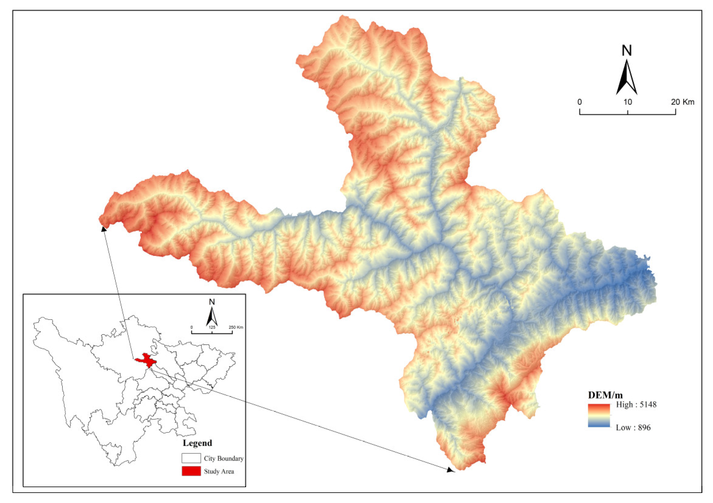
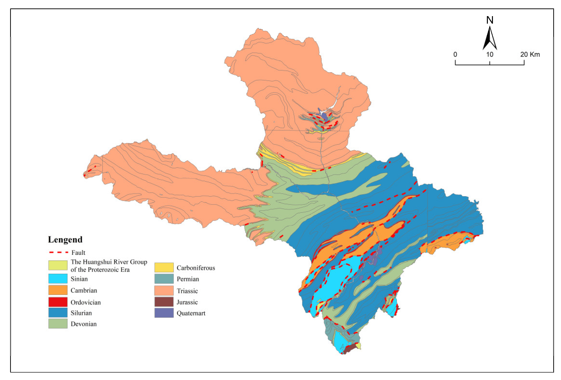
Maoxian County is located in the southeast of Aba Tibetan and Qiang Autonomous Prefecture, Sichuan Province (Figure 2), with a total area of 3896.3 km2. The topography is dominated by high-mountain gorges, with extensively developed Silurian Maoxian Group metamorphic rock series (Figure 3). The terrain is high in the northwest and low in the southeast. The elevation of the peaks is generally more than 4000 m, of which the main peak of the Wannian Snow Mountain in the west is 5230 m, and the lowest point of the Tumen River Valley in the east is only 910 m, with a relative height difference of more than 2000 m. Affected by the intersection of the eastern margin of the Qinghai–Tibet Plateau and the northern section of the Hengduan Mountains, the county formed a three-dimensional gradient structure of “deep incised canyon-steep slope transition zone-basin margin mountain”. The Minjiang River in the west was strongly incised to form a deep “V”-type canyon. The northern part is the steep slope area of the transition from alpine to plateau, and the trend for the mountains in the southeast involves a less steep slope and continuous hills. Because it spans the middle section of the Longmenshan fault zone and is located in the core zone of the XI intensity zone of the Wenchuan earthquake, the strong earthquake disturbance leads to a sudden drop in the integrity of the rock mass, forming a large-scale loose accumulation body, which makes it easy to trigger the “landslide–blocking river–burst–debris flow” chain of geological disasters under the action of rainfall and gravity [26,27].
A total of 11 towns (Fengyi town, Fushun town, Tumen town, Weimen town, Goukou town, Diexi town, Wadi town, Chibusu town, Shaba town, Heihu town, and Nanxin town), 104 administrative villages, 403 village groups, 12 resident groups, and 885 geological hazard points were found in the county (Table 1).
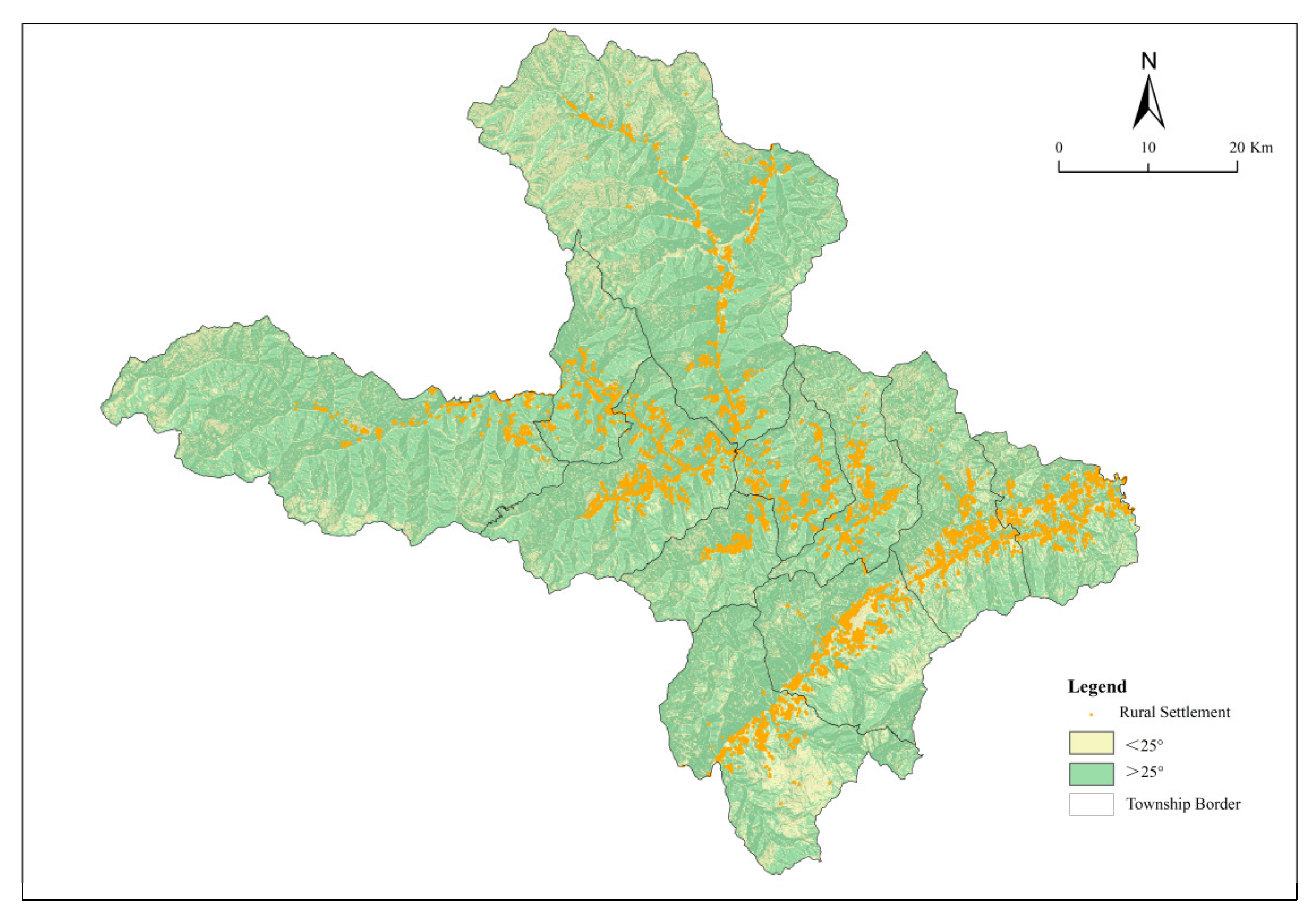
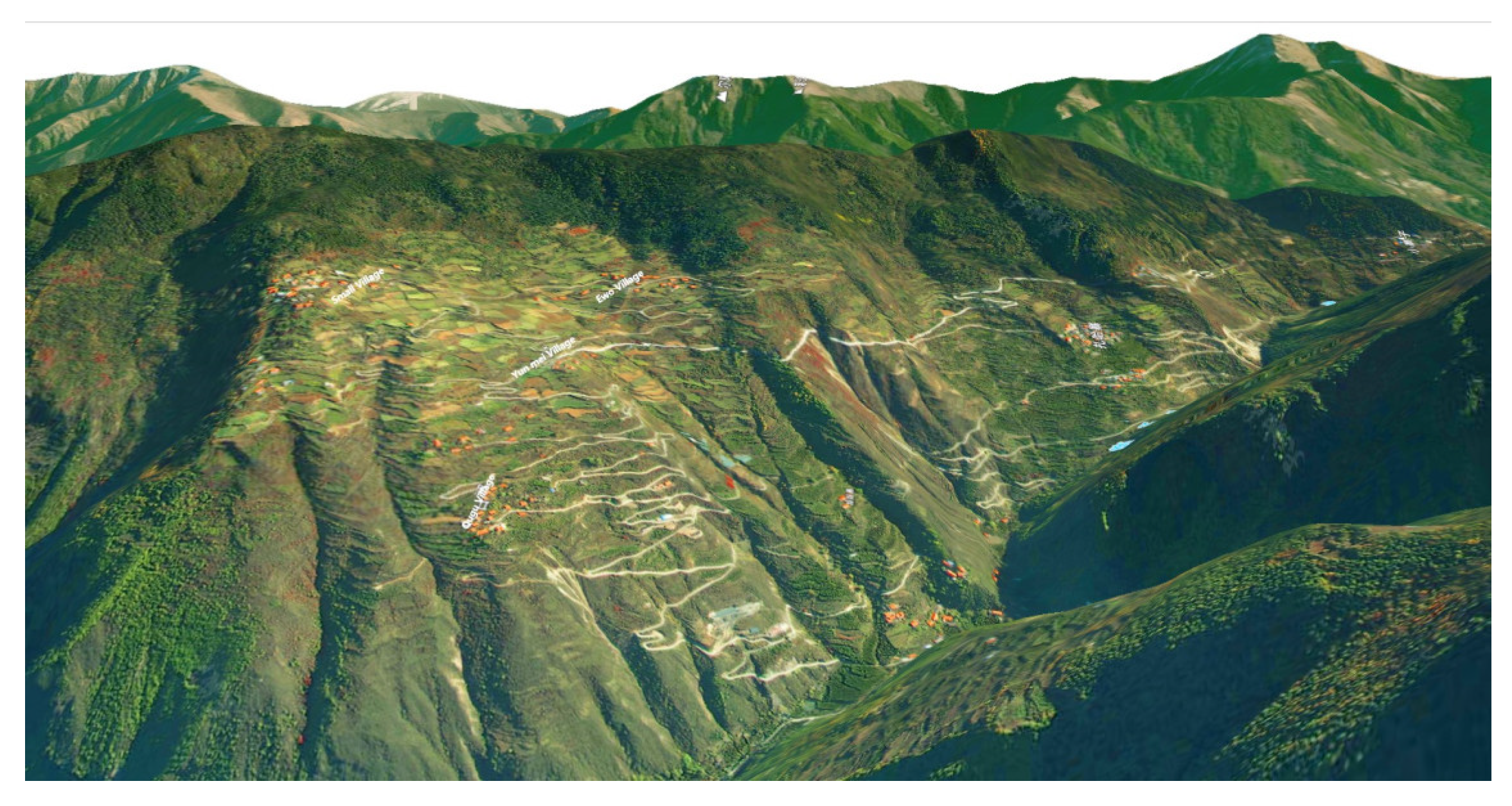
The human, social, and economic system of Maoxian County presents the characteristics of “three high and one fragile”: First, high ethnic population. Maoxian County is the largest Qiang core area in China, and the Qiang population accounts for 88.92% of the county. Traditional watchtowers and settlements are mostly distributed on >25° slopes in order to adapt to the steep slope environment (Figure 4 and Figure 5), which aggravates the risk of disaster exposure. The second is high disaster disturbance. In 2017, the Diexi landslide buried Xinmo Village, and other cases highlighted the vulnerability of disaster-bearing bodies. The national highway G213 was interrupted due to disasters, which restricted regional connectivity. The third is high development pressure. The construction of the Sichuan–Qinghai Railway and the operation of 61 hydropower stations aggravate the conflict between people and land. In 2023, the urbanization rate reached 52.68%, the permanent population of the county was 108,500, and the tertiary industry structure was 24.6:30.3:45.1. The tourism industry depends on Qiang culture (watchtower/Shibi) and natural landscape (Jiudingshan/Diexihaizi). Fourth, cultural inheritance is fragile. The destruction of settlement carriers and the outflow of population under disaster stress pose challenges to the inheritance of living culture, and it is urgent to coordinate ecological security and the survival of national cultural heritage. Therefore, Maoxian County has become a typical sample for analyzing the vulnerability of rural settlements in alpine gorge areas. In the natural background, “terrain gradient + chain disaster” constitutes an extreme stress environment. In the humanistic system, “steep slope settlement + national culture + rapid urbanization” forms a complex vulnerability-driving mechanism. The scientific understanding of the spatial differentiation of its vulnerability has urgent practical value for coordinating “ecological security–cultural heritage survival–rural revitalization”.

2.2. Data Sources and Preprocessing

A comprehensive assessment of the vulnerability of rural settlement systems in Maoxian County was conducted using multi-source data, covering three categories: spatial, remote sensing, and attribute data. Spatial data includes administrative division and land use data sourced from the 2020 Third Land Change Survey Database of Maoxian County, and 30 m resolution elevation data from the Geospatial Data Cloud platform of the Computer Network Information Center [28]. Soil erosion data was sourced from the Resource and Environment Science Data Center, Chinese Academy of Sciences [32]. Remote sensing data primarily consisted of normalized difference vegetation index sourced from the 2023 NASA MOD13A3 dataset [33]. Attribute data such as socioeconomic data was sourced from the “2023 Statistical Bulletin of National Economic and Social Development of Maoxian County” [34]. Other data sources include the “Overall Territorial Spatial Planning of Maoxian County (2020–2035)”, “Overall Territorial Spatial Planning of Maoxian Tumen Green Circular Economy Zone (2021–2035)” [35], “Overall Territorial Spatial Planning of Maoxian Goukou Ecological Governance Zone (2021–2035) [36]”, “Overall Territorial Spatial Planning of Maoxian Fengyi Industry-City Integration Zone (2021–2035) [37]”, “Overall Territorial Spatial Planning of Maoxian Diexi Cultural Tourism Resort Zone (2021–2035) [38]”, “Overall Territorial Spatial Planning of Maoxian Chibusu High-altitude Agricultural Specialty Zone (2021–2035) [39]”, “Maoxian Territorial Spatial Ecological Restoration Planning (2021–2035) [40]”, “Maoxian 14th Five-Year Plan for Comprehensive Transportation Development”, “Maoxian 2023 Annual Water Resources Bulletin [41]”, and “Maoxian Geological Disaster Survey Data (2024)”. Microscopic data on settlement population structure, infrastructure status, and cultural heritage were supplemented through field surveys, departmental interviews, and township discussions.

3. Research Methods

3.1. Vulnerability Assessment of Rural Settlement Systems

3.1.1. Index System Construction

To scientifically evaluate the vulnerability of the rural settlement system in Maoxian County under geological disaster stress, based on the Exposure-Sensitivity-Adaptive Capacity (VSD) evaluation framework proposed by Polsky et al. [42], this framework systematically integrates natural indicators (terrain slope, hazard frequency) with social indicators (population density, economic structure) to achieve comprehensive vulnerability analysis. Considering Maoxian County’s distinctive regional characteristics—complex alpine canyon topography, frequent geological hazards, fragile ecosystems, and limited arable land—this study adapts the VSD framework to local conditions based on established vulnerability research methodologies [18,43,44,45,46]. Following principles of systematicity, relevance, operability, and data availability, the adapted framework consists of three dimensions, eight components, and 25 specific indicators (Table 2). The framework operates on the principle that exposure and sensitivity exhibit positive correlations with vulnerability, while adaptive capacity demonstrates negative correlation with vulnerability [47].
Exposure (EI) characterizes the intensity and possibility of internal and external disturbances in the rural settlement system, especially the potential threat of geological disasters [48]. In Maoxian County, the intensity of exposure is mainly controlled by the following factors [18]: ① The intensity of natural environment disturbance, annual average precipitation, river network density, soil erosion intensity, number of important geological disaster hidden danger points directly reflect the potential occurrence frequency and intensity of major geological disasters in Maoxian County. ② The intensity of social and economic disturbance, select urbanization rate, proportion of rural settlements in the total land area, population distribution density, proportion of subsistence allowances and poverty monitoring households, per capita income level of farmers (reverse index; the lower the income, the weaker the impact of disturbance, and the stronger the exposure perception) reflect the disturbance of human activities, development pressure, and socioeconomic factors on the stability of the system. These indicators jointly describe the direct pressure sources of rural settlements in Maoxian County facing natural disturbances such as geological disasters and social disturbances such as urbanization. The higher the indicator value, the higher the degree of system exposure to adverse disturbances, and the greater the vulnerability risk.
Sensitivity (SI) characterizes the difficulty of adverse changes in the structure and attributes of the rural settlement system in the face of disturbances [49]. In the alpine gorge area of Maoxian County, the sensitivity of the system is highly affected by the topography and resource endowment constrained by the vertical band spectrum, which is mainly reflected in the following four aspects [44]: ① Natural background vulnerability, average altitude, average slope, surface undulation and normalized difference vegetation index (NDVI) (reverse index; low vegetation coverage means weak soil and water conservation capacity, and the ecosystem is more vulnerable) are selected to directly reflect the inherent vulnerability of topography and ecological base to disturbance. ② Resource supply constraints, select water supply (reverse index; water shortage aggravates system pressure), per capita arable land area, and garden area reflect the key resource endowments that support rural production and life and their susceptibility to interference. ③ Vulnerability of economic structure: The proportion of cultivated land and garden land located in high-risk areas of disasters and the added value of the primary industry, which reflect the direct exposure of core means of production to risks, are selected to reflect the sensitivity of the economic base to disasters. ④ Population structure vulnerability: The proportion of rural labor force (reverse index; sufficient labor force has great potential for recovery) and the proportion of population under 15 years old and over 65 years old (dependent and relatively static vulnerability attributes; the steeper and more complex the terrain, the scarcer and more singular the resources, the higher the economic dependence on nature, the greater the proportion of non-labor population, the more vulnerable the system is to damage under the same exposure, and the higher the sensitivity) are selected.
Adaptive Capacity (AI) characterizes the ability of rural settlement systems to cope with disturbances, mitigate potential losses, and recover from them through adjustment, management, and investment [50]. Maoxian County mainly improves its adaptability through infrastructure [45] and livelihood security [46]. The infrastructure selects regional road network density (reverse index; traffic accessibility affects rescue, material circulation, and post-disaster recovery efficiency) as the representative of key infrastructure. The people’s livelihood security ability selects the number of beds in medical institutions per 10,000 people, the number of disaster shelters per 10,000 people, the number of beds in social welfare homes per 10,000 people, and the number of middle school students per 10,000 people to measure the support ability of social services and security systems for residents to cope with disasters and maintain basic life. These metrics measure the resources and capabilities of the system to proactively respond and recover. The more perfect the infrastructure and the higher the level of public services, the stronger the ability of the system to absorb shocks, the better the organizational response and recovery and reconstruction, the higher the adaptability, and the greater the offsetting effect on vulnerability (VI).

3.1.2. Evaluation Model

Standardization of data processing
Because the selected indicators have different dimensions, in order to ensure the scientificity and rationality of the evaluation results, the range method is used to standardize the original data in the rural settlement vulnerability evaluation index system [51], and the indicators include positive indicators and reverse indicators.
The processing method of the positive index is as follows:
        y i j = x i j min x i j max x i j min x i j + 0.01
The processing method of the negative index is as follows:
y i j = max x i j x i j max x i j min x i j + 0.01
In Formulas (1) and (2), x i j   a n d   y i j represent the original data and standardized data of the i index of the j sample respectively, and max x i j and min y i j represent the maximum and minimum values of the i-th index respectively.
Subjective and objective combination weighting method
This study employs a combined subjective–objective weighting methodology to determine indicator weights within the assessment system. Subjective weights are derived through expert synthesis using the Analytic Hierarchy Process (AHP), while objective weights quantify indicator data information value using the CRiteria Importance Through Intercriteria Correlation (CRITIC) method. Composite weights are calculated as the arithmetic mean of subjective and objective weights from the CRITIC-AHP integration. This hybrid weighting approach balances the inherent characteristics of both methodologies to address limitations of individual weighting techniques. The method mitigates shortcomings of objective approaches, which lack comprehension of individual indicator influence levels, and biases from excessive subjectivity in purely subjective methods. The integration preserves data-driven rigor while incorporating expert knowledge of actual influencing factors, thereby enhancing both scientific validity and practical applicability of weight determination. The CRITIC method [52] reflects the contrast intensity by measuring the degree of index variation by standard deviation, and analyzes the conflict between indexes by means of correlation coefficient to reduce information redundancy. This method takes into account the dual effects of the index’s own variation and the correlation between the indicators and effectively reduces the weight overlap. The specific calculation steps are as follows:
Variability   of   indicators   s j = Σ i = 1 n x i j 1 n Σ i = 1 n x i j 2 n 1
Equation (3) reflects the degree of variation of the index in the form of standard deviation, and x i j represents the ith value of the index j ; s j represents the standard deviation of the j index, which reflects the degree of fluctuation of the difference between the values of each index. The greater the difference, the greater the standard deviation, which more significantly reflects the difference between the evaluation objects and is given a relatively large weight, that is, the greater the weight of the index   i .
The   conflict   of   indicators :   R j = i = 1 P 1 r i j
In Equation (4), r i j represents the mutual coefficient between evaluation indexes i and j and represents the correlation coefficient between index i and index j . The larger the coefficient value is, the stronger the correlation between the two indexes is, the higher the convergence is, and the smaller the conflict is. There is a large degree of overlap or information redundancy in the evaluation content, and it tends to give lower weight in the weight distribution.
Objective   weight :   w j = S j × R j j = 1 P S j × R j
In Equation (5), the subjective and objective combination weight of the j index is as follows: w j = β W a j + 1 β W b j , where Waj represents the CRITIC weight, and Wbj represents the AHP weight. It is considered that the subjective weighting method and the objective weighting method have the same importance, and β = 0.5.
Based on the SERV model of explicit space proposed by Frazier et al. [53] and the existing research results [54], the measurement method of rural settlement system vulnerability is as follows:
VI = EI + SI − AI
In Formula (6), VI represents vulnerability, EI represents exposure, EI represents sensitivity, and AI represents adaptability.

3.2. Vulnerability Classification of Rural Settlement System

In order to reveal the spatial differentiation pattern and dominant causes of the vulnerability of rural settlement systems in Maoxian County, this study uses the dominant factor method to classify the vulnerability types. Based on the comprehensive evaluation results, this method identifies the key dimensions that play a decisive role in the formation and differentiation of vulnerability in different township spatial units, and uses the dominant dimension as the core symbol to define the boundary of regional types [55]. This method can effectively reveal the dominant driving mechanism of spatial heterogeneity of vulnerability and provide a scientific basis for implementing differentiated risk management and resilience improvement strategies.

4. Results

4.1. Spatial Differentiation of Rural Settlement Vulnerability in Maoxian County

Using the established rural settlement vulnerability assessment framework, this study calculated standardized values for each indicator through Equations (1) and (2). The CRITIC method and AHP were applied to determine indicator weights via Equations (3)–(5). Exposure, sensitivity, and adaptive capacity for rural settlements across Maoxian County townships were computed using the weighted sum tool in ArcGIS 10.4.(ArcGIS Desktop, Version 10.4, manufactured by Esri, Redlands, CA, USA). The spatial vulnerability model defined in Equation (6) subsequently generated vulnerability assessment indices for rural territorial systems throughout the county’s townships. Natural breakpoint analysis classified vulnerability scores into low, medium, and high categories (Table 3), with spatial distributions visualized in ArcGIS 10.4.

4.1.1. Exposure

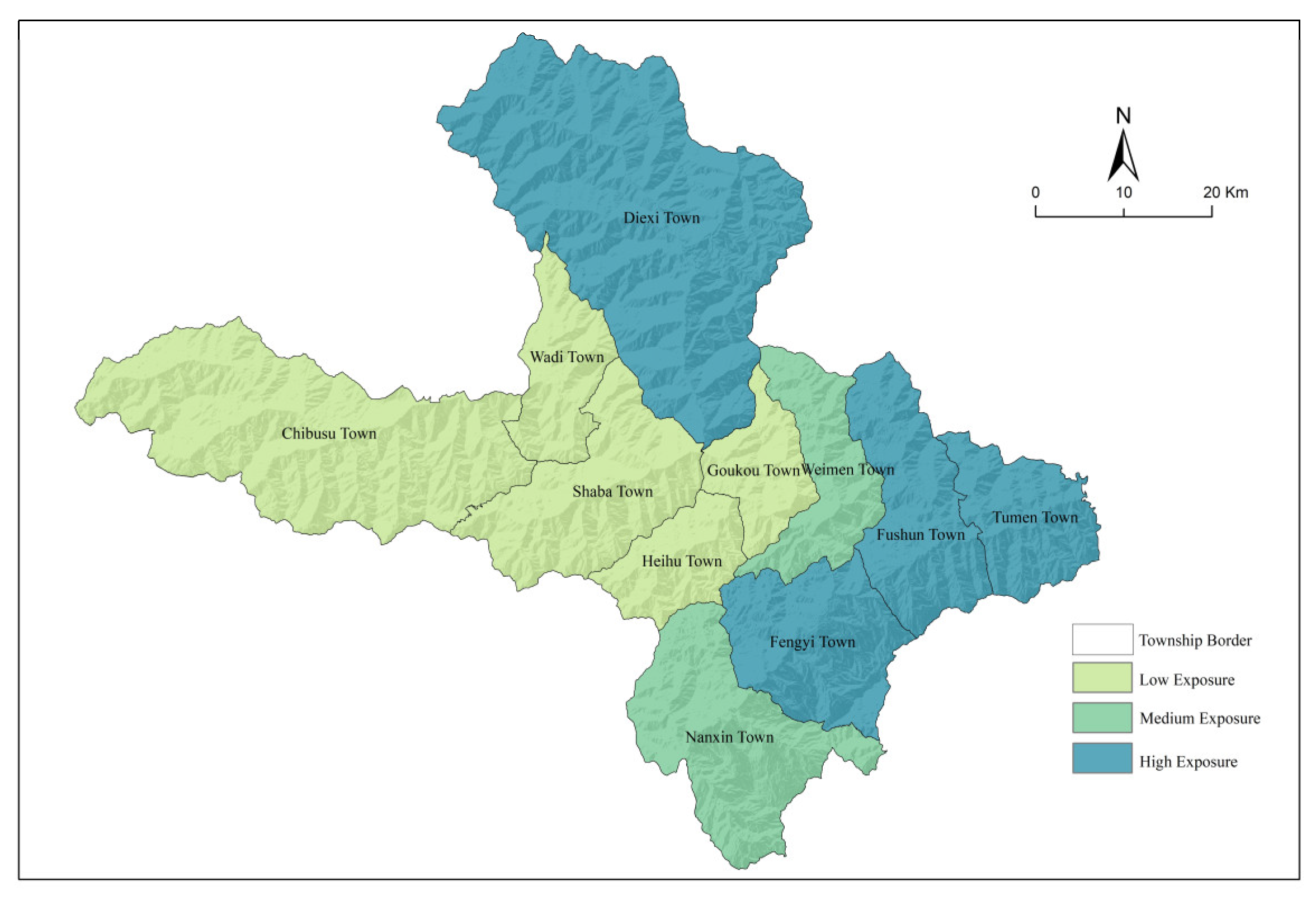
The exposure index of rural settlements in 11 townships in Maoxian County is at a high overall, with an average value of 0.1348 and a median of 0.1181, indicating a clear geographical differentiation pattern of “high in the east and low in the west” (Figure 6). It is the result of the dual pressures of “natural stress type” and “human activity dominant type”. The eastern deep valley area is a high-exposure core area that includes Fengyi Town, Diexi Town, Fushun Town, and Tumen Town. The Minjiang River and its tributaries pass through this area. The density of the river network is high, as is the yearly rainfall. For example, the annual rainfall of Diexi Town and Tumen Town surpasses 730 mm, which worsens slope runoff and soil erosion. At the same time, the fracture of rock mass in the fault zone induces the dense distribution of hidden danger points of geological disasters, and the risk of chain disaster is prominent. Furthermore, 56.2% of the county’s population resides in the deep valley area in the eastern part, Fengyi Town has a 56.05% urbanization rate, a population density of 150.4 people/km2, and the steep slope reclamation is layered on top of the disruption of the G213 traffic trunk line, creating a double pressure known as “disaster-livelihood”. The exposure is further increased when the stress of human activity is layered on top of the chain catastrophe risk. Five towns—Wadi Town, Shaba Town, Wadi Town, Heihu Town, and Goukou Town—are located in western China’s low-exposure zone. In the post-disaster reconstruction, this area continues to promote high-altitude population migration, and the low population density reduces the intensity of human–land conflict. Terrain limits also limit settlement expansion and minimize human activity disturbance. Nanxin Town and Weimen Town are among the regions that are exposed. The two cities are situated in the transition zone of “deep canyon-basin edge mountain”, with medium topographic relief, moderate density of disaster hidden hazard locations, and medium spatial threat. Although the hydropower station in Nanxin Town has the highest proportion in the county, the Sichuan–Qinghai Railway also passes through Weimen Town, but the associated engineering protection decreases the risk.

4.1.2. Sensitivity

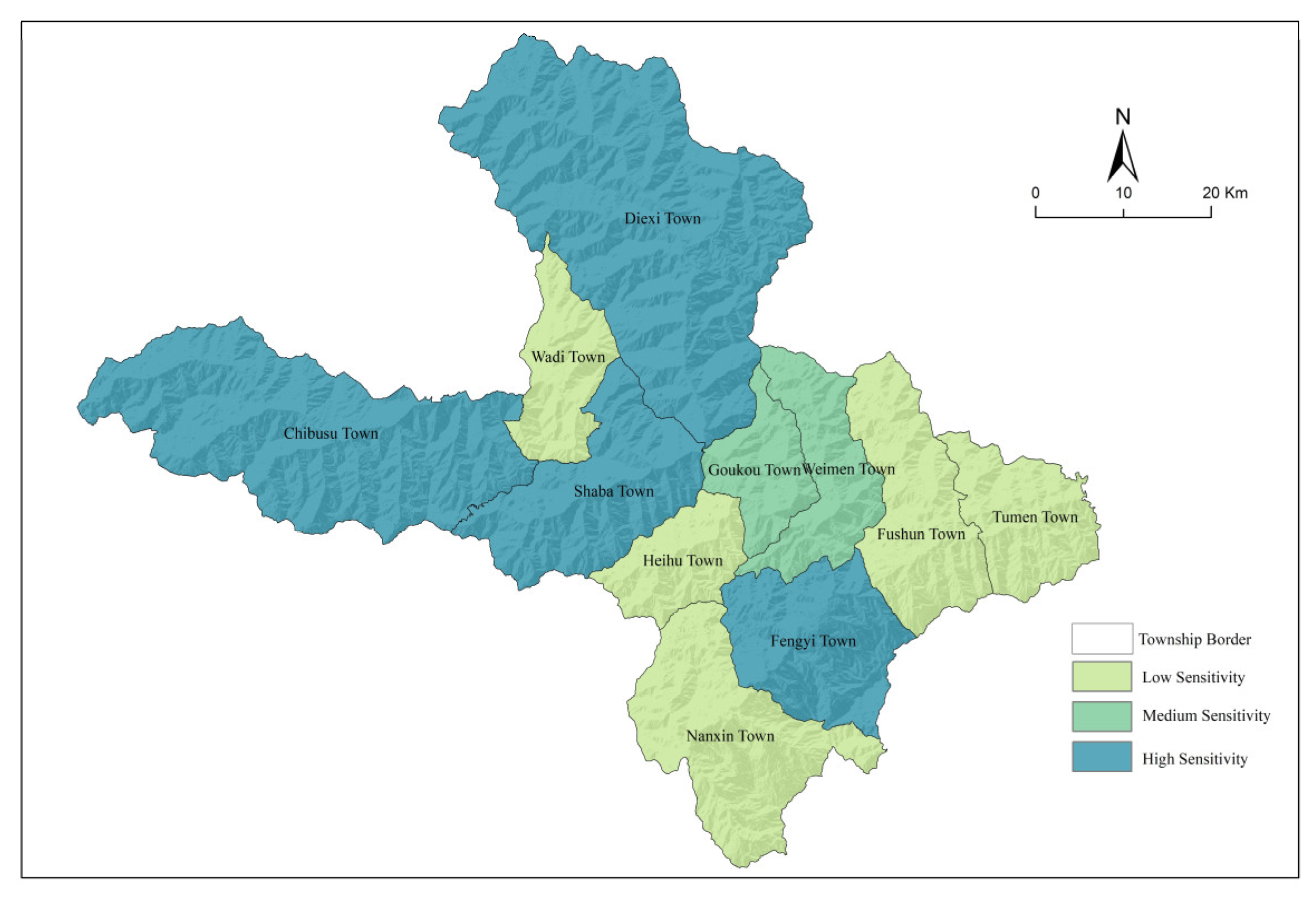
The sensitivity index of rural settlements in Maoxian County is at a high level as a whole, with an average value of 0.1769 and a median value of 0.1709. The regional distribution exhibits a considerable “northwest high and southeast low” differentiation pattern (Figure 7). Shaba, Chibusu, Diexi, and Fengyi towns are among the northwest’s most vulnerable places. The sensitivity is the spatial combination of “natural background sensitivity” and “socioeconomic vulnerability”. The topography in these places is steep, with an average slope of 31.51°. More than 70% of all agricultural land and gardens are located on slopes greater than 28°. Soil erosion is highly sensitive due to the combination of high altitude and extensive terrain variation, limiting agricultural production due to irrigation water scarcity and frequent disruption from geological disasters. At the same time, the traditional farming mode is obliged to continue due to the fragmentation of arable land, the aging of population structure, the low birth rate, and the outflow of young and middle-aged people, which exacerbate the “hollowing sensitivity”, resulting in a natural–social composite pressure. The southeast’s low-sensitivity zones comprise five townships: Tumen Town, Fushun Town, Wadi Town, Heihu Town, and Nanxin Town. These areas have relatively mild slopes, a low fraction of high-risk cultivated land for geological disasters, and extensive plant cover. The ecosystem’s stability is preserved, although its sensitivity is greatly reduced. The sensitive locations are Goukou Town and Weimen Town. The topographic relief of the two towns is the median of the whole region, which partially buffers the typical soil erosion chain reaction in the alpine gorge area. Tourism and agricultural product processing industries reduce the sensitivity of single agriculture to natural disturbances.

4.1.3. Adaptability

The adaptability index of rural settlements in Maoxian County is poor overall, with an average value of 0.0811 and a median value of 0.0823. The spatial distribution exhibits a substantial differentiation pattern of “high in the southeast and low in the northwest” (Figure 8), which is limited by the geography of alpine canyons and the availability of public amenities. The high-adaptability area in the southeast centers on Fengyi Town, leveraging the county’s location advantages, consolidating 75% of the county’s medical resources and 90% of high-quality schools, forming a composite support system for medical, educational, and social welfare facilities, and systematically improving disaster resilience. The adjacent Tumen Town and Goukou Town offer protection against natural hazards by the robustness of their transportation networks. The geography in the northwest limits adaptation greatly. The region’s average road density is 17.27 km/100 km2, significantly lower than Sichuan Province’s average of 85.8 km/100 km2. The poor road network causes a lag in disaster aid response. The location is the farthest from the county town of Fengyi, making it difficult to exchange public service resources. The medical coverage flaw, the structure of emergency shelters, and the spatial distinction of catastrophes are all incorrect, and it is caught in the compound vulnerability conundrum of “natural high risk-low adaptability”.

4.1.4. Vulnerability

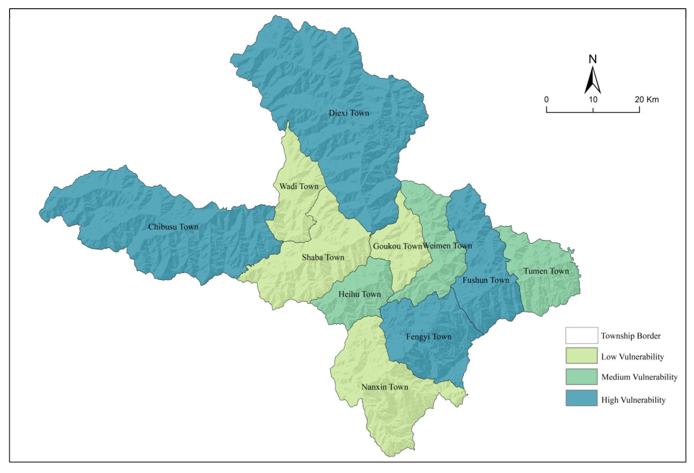
The average vulnerability index for rural settlements in Maoxian County is 0.2306, with a median of 0.2234. The regional differentiation revealed a typical dual-core structure of “northwest disaster sensitive type” and “southeast socioeconomic pressure type”, with the comprehensive value increasing from southeast to northwest (Figure 9). Diexi Town is the focal point of the northwest’s very-high-vulnerability area. Constrained by the deep canyon terrain, it is easy to form a high-level landslide-heavy rain-steep slope farming disaster chain threat, and the road network is sparse, emergency facilities are insufficient, adaptability is the lowest in the entire region, and vulnerability is significantly increased. Chibusu Town’s vulnerability exceeded the threshold (≥0.2912) due to a problem with steep slope reclamation and public service. Human engineering operations, such as hydropower station development, disrupt middle- and high-vulnerability places like Heihu Town and Tumen Town, exacerbating natural hazards and positively feeding back to exposure and sensitivity. The low-vulnerability districts in the southeast of Fengyi Town and Nanxin Town benefit from the alpine canyon’s comparatively easy slope. Urbanization agglomeration and external transportation convenience constitute the “infrastructure-service” double support, which considerably increases system resilience and buffers against high exposure risks. This pattern is strongly influenced by the combination between alpine canyon terrain and human activity. Because of the high terrain and natural limits of the canyon, the northwest’s reliance on traditional agriculture has increased sensitivity, and the combination of financial weakness has fallen into the “low adaptability trap”; while the southeast improves resilience through resource tilt, human construction activities increase exposure risks.

4.2. Vulnerability Types Division

4.2.1. Vulnerable Areas and Vulnerability Type Division

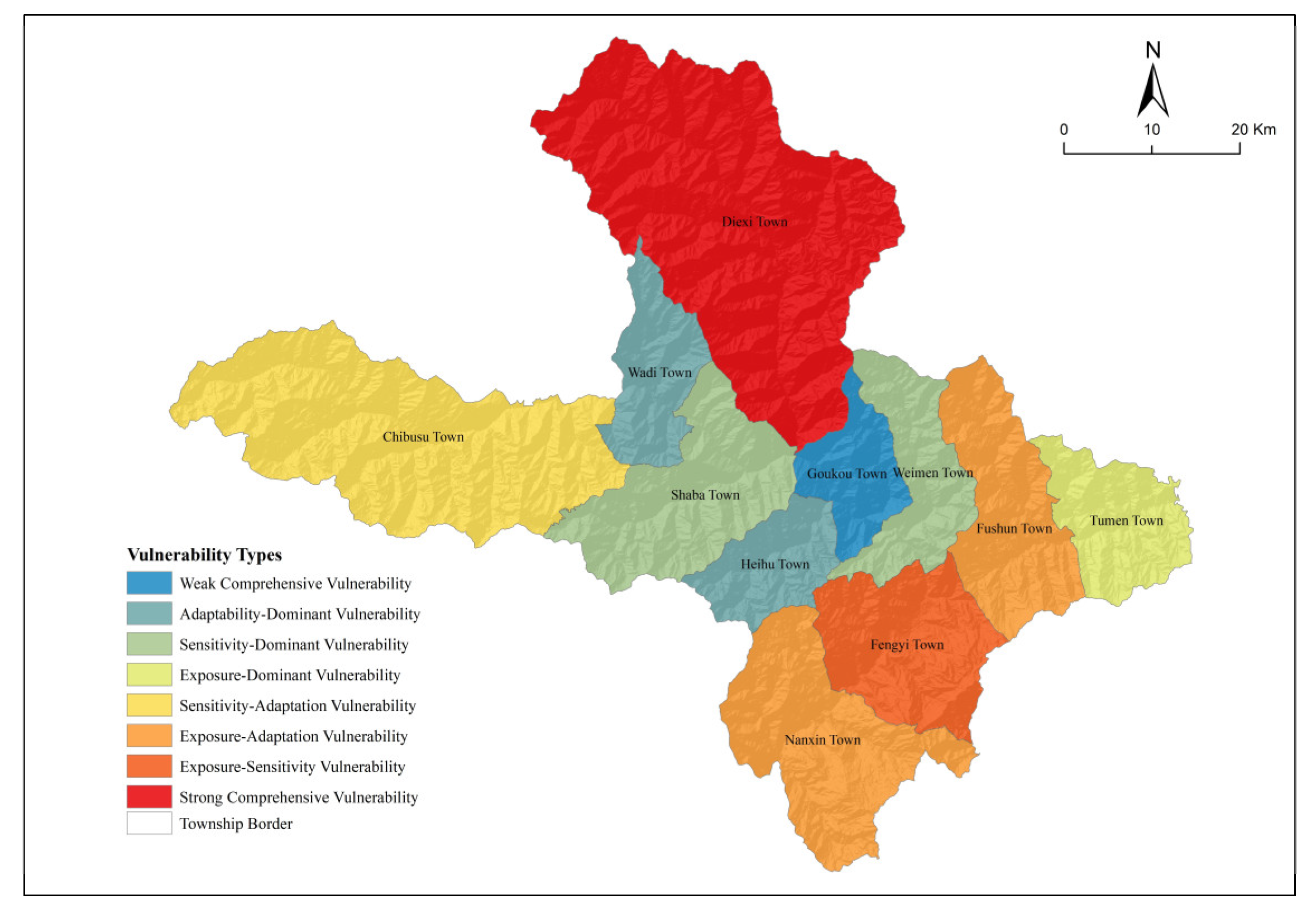
When the three dominant factors of the vulnerability of the rural settlement system in Maoxian County are combined, this type is defined as strong comprehensive vulnerability (high exposure–high sensitivity–low adaptability). When there are two dominant elements, they are classified into three types: exposure-sensitive vulnerability type (high exposure–high sensitivity), exposure-adaptive vulnerability type (high exposure–low adaptability), and sensitive-adaptive vulnerability type. When the number of dominant factors is one, the dominant factor kinds are as follows: exposure vulnerability type (high exposure), sensitivity vulnerability type (high sensitivity), and adaptability vulnerability type (poor adaptability). When the number of dominant factors is 0, it is defined as weak comprehensive vulnerability (low exposure–low sensitivity–high adaptability); there are 8 types (Figure 10). The vulnerability measurement results are superimposed with the preliminary vulnerability classification types to obtain the specific types of township vulnerable areas in Maoxian County (Table 4).

4.2.2. Vulnerability Characteristics

Strong comprehensive vulnerability type (Diexi Town): The town combines Maoxian County’s core area of natural pressure with its weak area of social security. The alpine canyon environment contributes to a high background value of geological disaster risk, and there is a severe deficit of vital infrastructure and social security such as roads, medical care, emergency shelter, social welfare, and education. The exposure, fragility, and recovery ability of rural settlements to external pressure are all significant challenges.
Exposure-sensitivity vulnerability type (Fengyi Town): The town is the focus area of social and environmental pressures. As the county’s central town, it features a highly concentrated population, a high level of urbanization, dense settlements, intense human activities, widespread arable land resources, and a relatively high added value of the primary industry. The social and economic system is highly sensitive to disturbances. At the same time, the number of geological hazard points is high, and the landscape in the southern region is undulating, with a high rate of soil erosion. As a result, a prominent “human activity–hydrological process–geological disaster” chain effect developed, considerably increasing the region’s exposure and sensitivity.
Exposure-adaptation vulnerability type (Nanxin Town, Fushun Town): Its high susceptibility is defined by a combination of high exposure and low adaptation. The dense regional water network, the vast number of concealed risk spots of geological disasters, and the significant geographical overlap between river distribution, geological disaster locations, and soil erosion areas all limit the high level of exposure. The river’s dynamic motion can easily cause landslides and debris flows. At the same time, it produces a typical “erosion-transport-disaster canyon chain” as the primary “carrier” of soil erosion. The lack of adaptation is evident in the relative lag of public services such as medical and health care, emergency shelter, social welfare, and education, all of which impede rural communities’ disaster response and recovery capabilities.
Sensitivity-adaptation vulnerability type (Chibusu Town): The town’s vulnerability stems mostly from its high sensitivity and lack of adaptation. The extreme sensitivity is attributed to the usual deep-cutting alpine gorge landform. The high mountain area makes up a substantial share, and the natural habitat is fragile. With a high proportion of primary industry and a single economic structure, it is extremely vulnerable to changes in the natural environment and disasters.
Exposure-dominated vulnerable type (Tumen Town): The primary driving force behind this form of susceptibility is high exposure. Due to the high yearly precipitation, the spatial distribution of soil erosion and geological hazard concealed spots are highly correlated, resulting in a chain risk. Although the terrain is gentle in comparison to the northwest and the sensitivity does not exceed the dominant threshold, human development activities as a green circular economy area continue to disrupt slope stability, and the existing traffic network density and emergency facility configuration fail to effectively buffer the high exposure risk, resulting in the system’s overall vulnerability exhibiting significant exposure-oriented characteristics.
Sensitivity-dominated vulnerability type (Weimen Town, Shaba Town): The essence of its vulnerability stems from the prevailing mechanism of high sensitivity. Shaba Town, as a typical example, has the lowest exposure degree in the county due to population migration, yet it is limited by the high topography of alpine canyons. The traditional slope farming model is constrained by the dual pressures of irrigation water scarcity and soil erosion; at the same time, the socioeconomic system’s “hollowing sensitivity” contributes to its poor self-recovery potential. The spatial superposition of natural backdrop and socioeconomic sensitivity becomes the primary reason for increased vulnerability.
Adaptability-dominant vulnerability type (Wadi Town, Heihu Town): Vulnerability is manifested as a systemic short board with low adaptability. The limited road network density causes a significant lag in disaster response, and the steep and narrow terrain restricts the spatial coverage of public service facilities. In addition to making it challenging to share the county emergency response system’s support, the supply failures of essential resources like medical beds and disaster shelters also impose the strict limitations of steep slope reclamation on industrial transformation, creating a vicious cycle of “continuous accumulation of natural risks–continuous attenuation of adaptability”. Lack of adaptability has emerged as the primary barrier to vulnerability evolution against the backdrop of exposure and sensitivity not reaching the dominant threshold.
Weak comprehensive vulnerability type (Goukou Town): This type demonstrated a positive synergistic impact of limited exposure, low sensitivity, and great adaptability. Goukou Town, as an important region of ecological management, effectively maintained ecosystem stability through high vegetation covering, with much fewer geological danger points than the county average. Natural disturbance sensitivity is minimized using the Qiang settlement’s traditional ecological wisdom (for example, the disaster prevention arrangement of the watchtower group). At the same time, it benefits from the proximity of the nearby regional service center. The accessibility of the road network and the level of medical resource distribution provide an adaptive comparative advantage. The three-dimensional benign mutual feedback creates a low-fragility and resilient foundation.

4.3. Differential Regulation Countermeasures

4.3.1. General Requirements

Based on the vulnerability differentiation law of the “nature–economy–society” composite system, the resilience improvement path of “ecological foundation construction, industrial hematopoiesis, strong facilities and institutional shaping” is constructed from the county scale. 1 Ecological foundation. Strictly abide by the requirements of land space bottom line control, and delineate the extremely high risk area of geological disasters, the red line area of ecological protection, the steep slope greater than 25° and the water source area as the “ecological forbidden area”; through the ecological corridor, repair the fragile habitat of alpine canyon. 2 Industrial hematopoiesis. Promote the transfer of industry to the middle- and low-altitude valley, reduce the pressure of steep slope reclamation; the integration system of “vertical gradient agriculture-Qiang cultural value chain-ecotourism” is constructed to form a closed loop of “planting-processing-cultural tourism”. 3 Strong facilities. Improve the accessibility of rural roads and layout of disaster-adaptive road networks, and develop integrated wind, solar and energy storage in high-altitude areas; construct an integrated geological disaster monitoring network system. 4 System shaping. Combined with the overall planning of land space in Maoxian County, five township-level governance units are formed, five unitized public service cores are configured, and three-color zoning control of geological disasters is implemented for disaster prevention: forced relocation of extremely high-risk areas, engineering protection of high-risk areas, and joint community prevention of medium–low-risk areas.

4.3.2. Differential Regulation

Through differentiated intervention and breaking the vicious cycle of “exposure–sensitivity–adaptation”, the paradigm shift from vulnerability mitigation to resilience construction is realized according to the principle of “ecological security anchoring–system hierarchical regulation–chain risk blocking–space precise adaptation”.
Strong comprehensive vulnerability type (Diexi Town). This involves comprehensive vulnerability reduction through systematic risk decomposition and resilience reconstruction. Ecological restoration includes establishing ecological exclusion zones in high-risk landslide areas and rehabilitating water-source conservation forests. Developing ecological restoration services to replace traditional agriculture creates a “disaster avoidance–ecology–livelihood” integration model. A dual-track emergency response system combining “Qiang clan mutual aid networks with professional rescue teams” incorporates traditional “Sibi culture” disaster prevention knowledge.
Exposure-sensitivity vulnerability type (Fengyi town). This involves reducing exposure and sensitivity through spatial defense and risk mitigation by converting frontline exposed areas into blue-green infrastructure. Cultivating low-exposure service industries and promoting integrated primary–tertiary sector development enhance economic resilience. Establishing a regional smart emergency command center enables county-wide disaster data sharing. GIS-based geological hazard pathway simulation facilitates bio-barrier deployment and soil moisture monitoring networks. Participatory mapping of “rural community risk maps” improves villagers’ risk awareness and self-evacuation capabilities.
Exposure-adaptation vulnerability type (Nanxin Town, Fushun Town). This involves strengthening engineering resilience and cultivating adaptive capacity through technical protection zones that combine geotechnical engineering with ecological slope stabilization to form disaster barriers. Constructing distributed reservoirs and disaster-resistant facility agriculture enhances agricultural resilience in arid river valleys. Establishing enterprise–community disaster prevention alliances and pre-positioned emergency storage systems boosts industrial economic resilience.
Sensitivity-adaptation vulnerability type (Chibusu Town). This involves implementing dual-track interventions of sensitivity reduction and adaptation enhancement. Advancing ecological conversion of steep slopes (≥25°) through agroforestry systems reduces agricultural sensitivity dependence, sustaining population relocation from high-altitude to lower-elevation areas while improving co-construction and shared utilization of rural road infrastructure and public services. Reviving the Qiang ethnic group’s traditional “Yihua Ping” deliberative mechanism integrates indigenous disaster prevention knowledge.
Exposure-dominated vulnerability type (Tumen Town). This involves isolating exposure sources at origins and upgrading protective systems and designating “disaster buffer zones,” relocating residents from exposed areas to low-altitude terraces, constructing sediment retention dams in valley areas, and establishing deep-rooted mixed tree–shrub forests to form biological barriers. Developing spatial defenses, valley-adaptive agriculture, and strengthened management of minor to moderate geological hazards, and promoting regional co-construction and sharing of disaster prevention facilities enhance disaster resilience.
Sensitivity-dominated vulnerability type (Weimen Town, Shaba Town). This involves implementing vertical ecological governance by establishing “ecological corridor-terraced fields-settlements” vertical structures to reduce erosion kinetic energy. Forming geological hazard monitoring teams integrated into community-based monitoring and prevention systems enhances rural community participation. Establishing “ecological guardian” position subsidy systems broadens employment channels.
Adaptability-dominated vulnerability type (Wadi town, Heihu Town). Regional resilience hubs are constructed through regional emergency supply reserve centers and multi-functional shelters while enhancing transportation network redundancy, developing county-level disaster resource dispatch platforms and refining cross-town emergency response protocols. Creating “strong villages supporting weaker villages” mutual aid alliances allows for sharing disaster prevention organizational expertise.
Weak comprehensive vulnerability type (Goukou Town). Preventive conservation and cultural resilience preservation is implemented through biodiversity monitoring networks and ecological baseline threshold alerts. Maoxian’s regional culture is revitalized through digital empowerment of Qiang watchtowers and low-disturbance ecological agriculture. Negative list management systems for construction activities are enforced while strengthening community self-organization capabilities in rural disaster prevention through “Qiang New Year Festivals.”

5. Conclusions

This study reveals that the resilience of rural settlements in Maoxian exhibits a gradient differentiation characterized by “extreme fragility in the northwest and southeast, and strong resilience in the central region.” This phenomenon fundamentally stems from the spatial misalignment between geological hazard risks and the socioeconomic system. The main conclusions are as follows:
(1)
Under geological hazard stress scenarios, the vulnerability of rural settlement systems manifests as the dynamic response state of human–land coupled systems to internal and external disturbances. This state fundamentally reflects the nonlinear feedback between disturbance intensity and recovery capacity, embodying both the spatial destruction intensity of disasters on settlements and the system’s self-organized resilience. Its core dimensions can be deconstructed into exposure sensitivity and adaptive capacity.
(2)
Significant spatial differentiation of vulnerability and multidimensional coupling serve as core drivers. Exposure in Maoxian’s rural settlements exhibits a distinct “east-high, west-low” spatial pattern under dual pressures of “human activity-dominated” and “natural stress-type” hazards. Sensitivity displays a “northwest-high, southeast-low” spatial differentiation, reflecting the spatial superposition of “natural baseline sensitivity” and “socioeconomic vulnerability.” Adaptability exhibits a “high in southeast, low in northwest” spatial pattern, reflecting a polarized structure dominated by “infrastructure-driven” and “public service deficit” factors. Rural settlement vulnerability in Maoxian County shows a “high in northwest–southeast, low in central” spatial distribution, resulting from the dual-core structure of “northwest disaster sensitivity” and “southeast socioeconomic pressure.” Research indicates that the core contradiction in Maoxian’s high-vulnerability zones lies in the conflict between “ecological security barrier functions” and “rural development demands”: The high-vulnerability northwest requires strict adherence to ecological protection redlines to interrupt disaster chains, yet traditional agriculture relies on steep slope cultivation, and industrial transformation lacks financial and technical support. The southeastern high-vulnerability zone relies on urbanization for economic growth, yet population and industrial concentration amplify exposure risks to geological hazards, while existing disaster prevention facilities struggle to address the chain reactions triggered by human activities and geological disasters.
(3)
Differentiated regulation is imperative. The vulnerability of rural settlement systems in Maoxian County is categorized into eight types: strong comprehensive vulnerability, exposure-sensitivity vulnerability, exposure-adaptation vulnerability, sensitivity-adaptation vulnerability, exposure-dominated vulnerability, sensitivity-dominated vulnerability, adaptation-dominated vulnerability, and weak comprehensive vulnerability. Following the principle of “Ecological Security Anchoring—System Graded Regulation—Chain Risk Interruption—Spatial Precision Matching,” differentiated approaches guide the reduction in vulnerability in rural settlement systems: For high-integrated vulnerability, a tripartite collaborative system is established, integrating ecological restoration, industrial structure optimization, and emergency capacity enhancement to achieve vulnerability reduction. Exposure-Sensitivity Vulnerability should reduce exposure and sensitivity through blue-green space substitution, smart early warning systems, and enhanced villager risk awareness. Exposure-Adaptation Vulnerability should cultivate adaptive capacity and resilience by constructing protective works and coordinating enterprise–township disaster response to reduce exposure. Sensitivity-Adaptation Vulnerability should lower disaster sensitivity and enhance adaptive resilience through farmland-to-forest conversion and cultural empowerment. For exposure-dominant vulnerability, agricultural structures in rural settlements should be adapted to enhance disaster resistance by designating “disaster buffer zones” and jointly building disaster prevention facilities with townships to reduce exposure. For sensitivity-dominant vulnerability, ecological sensitivity regulation and vertical spatial governance should be implemented while repatriating returning populations to mitigate aging. For adaptation-capacity-dominant vulnerability, transportation, emergency response, and educational infrastructure should be improved. For the weak comprehensive vulnerability type, preventive conservation should be implemented and cultural resilience sustained.
Overall, the resilient development of rural settlements must confront the deep-seated contradiction between the rigid constraints of natural stressors and the elastic growth of development demands. It requires breaking away from traditional single-factor disaster reduction thinking, shifting from disaster loss reduction to disaster-adaptive development, identifying key risk nodes and critical vulnerability dimensions, and enhancing disaster adaptation capacity through differentiated regulation.

6. Discussion

(1)
Comparison with rural settlement systems in other typical regions
Regional differences in natural environments, human–land relationships, resource endowments, and distinctive cultures necessitate developing region-specific indicator systems for rural settlement vulnerability assessment—a core research focus. Comparative analysis with studies in the Loess Plateau’s hilly gully areas [22] reveals that while both investigations employ the VSD model as their core framework, regional differences in environmental stressors generate distinct evaluation systems and outcomes. Chen Feng et al. developed an indicator system emphasizing soil erosion modulus, land use intensity, farmland fragmentation, and soil organic matter content to address progressive soil erosion characteristic of the Loess Plateau. Conversely, Maoxian County represents a typical high-mountain gorge region where frequent geological hazards and steep-slope settlements necessitate additional indicators including geological hazard site density, proportion of high-risk disaster areas within cultivated land, and disaster shelter availability per 10,000 residents. This approach enables more accurate analysis of how Maoxian’s episodic, high-intensity geological hazards impact rural settlement system vulnerability.
(2)
Study Limitations
① Insufficient spatial scale resolution: Township-level evaluation obscures inter-village vulnerability differences. Data scale limitations result in township-level assessments masking village-level variations—for instance, the vulnerability disparity between Xinmo Village (affected by 2017 landslides) and other villages within Diexi Township remains inadequately captured. Furthermore, focusing exclusively on Maoxian County without integration into the broader western Sichuan high-mountain gorge regional context precludes vulnerability comparisons with neighboring counties (e.g., Wenchuan, Litang), thereby limiting regional applicability of findings.
② Inadequate consideration of inter-village resource and industrial differentiation: Significant disparities exist among villages within identical townships regarding natural resource conditions (arable land quality, water resource accessibility, forest coverage) and specialized industrial orientations (traditional agriculture, Qiang ethnic cultural tourism, livestock farming). This generates potentially overly broad township-level vulnerability classifications, limiting precision and operational feasibility of differentiated regulatory strategies.
③ Temporal discontinuity and static analysis: The study employed static 2023 data for vulnerability assessment without analyzing post-2008 Wenchuan earthquake or post-2017 Diexi landslide vulnerability trajectories, precluding investigation of “disaster occurrence–system recovery–vulnerability evolution” cycles.
④ Cultural specificity underrepresentation: Given the cultural distinctiveness of Qiang ethnic settlements in western Sichuan’s high-mountain canyon regions, current research exhibits significant limitations in assessing cultural resource distribution impacts on rural settlement system vulnerability, failing to adequately capture the “vulnerability consequence amplification effect resulting from cultural carrier immobility.”
(3)
Future Research Directions
① Spatial scale refinement and geographical expansion: Future studies should adopt village-level evaluation scales through field surveys collecting micro-level data on village-specific disaster risk points, population structures, and infrastructure conditions. Integration with high-resolution remote sensing imagery to extract settlement distribution and vegetation coverage information will enable precise inter-village vulnerability characterization. Simultaneously, expanding study areas to encompass major counties throughout western Sichuan’s high-mountain canyon region (Wenchuan, Litang, Maoxian, Songpan) will facilitate cross-county vulnerability pattern comparisons, analyzing regional commonalities and distinctive characteristics to enhance research generalizability.
② Evaluation system enhancement: Future research should deepen granular analysis of village-level resource endowments and industrial characteristics. For resource endowments, village-level evaluation systems should be constructed based on micro-topography, incorporating arable land quality, water resource quality, and soil quality indicators to optimize resource endowment assessments. For industrial characteristics, village-level industrial differentiation evolutionary mechanisms should be traced through historical document analysis and farmer livelihood interviews. Resilience assessment frameworks should be developed tailored to distinct village typologies—traditional agricultural villages, Qiang ethnic cultural tourism villages, and ecological agriculture villages—identifying intrinsic relationships between industrial structure and vulnerability while establishing differentiated analyses linking industrial characteristics with adaptation strategies.
③ Temporal dimension strengthening: Future investigations should conduct longitudinal vulnerability analyses revealing dynamic evolutionary processes following the Wenchuan earthquake and Diexi landslide, exploring vulnerability factor shifts and interactive mechanisms.
④ Cultural resource quantification: Vulnerability in ethnic regions requires consideration of cultural resource distribution effects. In core Qiang cultural areas (Chibus Town, Heihu Town), distinctive ethnic cultural carrier immobility (watchtowers, altars) results in more severe vulnerability consequences even under exposure levels comparable to ordinary villages. This characteristic requires systematic quantification in subsequent research.

Author Contributions

Conceptualization, X.S.; Methodology, X.X. and X.S.; Software, X.X.; Validation, X.X.; Formal analysis, X.X.; Investigation, X.X. and X.S.; Resources, X.X. and X.S.; Data curation, X.X.; Writing – original draft, X.X., X.S. and T.W.; Writing – review & editing, X.S., T.W., X.W. and K.H.; Visualization, X.X.; Project administration, X.S.; Funding acquisition, X.S. All authors have read and agreed to the published version of the manuscript.

Funding

This research was funded by Youth Fund of Natural Science Foundation of Sichuan Province, 2022NSFSC1170.

Institutional Review Board Statement

Not applicable.

Informed Consent Statement

Not applicable.

Data Availability Statement

The original contributions presented in this study are included in the article. Further inquiries can be directed to the corresponding author.

Conflicts of Interest

Author Huang Ke are employed by Sichuan Zhongjia Wanxing Architectural Design & Planning Co., Ltd. The remaining authors declare that the research was conducted in the absence of any commercial or financial relationships that could be construed as a potential conflict of interest.

References

  1. Wu, X.Y.; Zhu, C.L.; Yu, J.B.; Zhai, L.; Zhang, H.X.; Yang, K.J.; Hou, X.L. Ecological Vulnerability in the Red Soil Erosion Area of Changting under Continuous Ecological Restoration: Spatiotemporal Dynamic Evolution and Prediction. Forests 2022, 13, 2136. [Google Scholar] [CrossRef]
  2. Ru, S.F.; Ma, R.H. Assessment, spatial analysis and prediction of ecological environment vulnerability in the Yellow River Basin. J. Nat. Resour. 2022, 37, 1722–1734. [Google Scholar]
  3. Yang, L.; Wang, S. Analysis of farmers’ vulnerability and its influencing factors in poverty-stricken areas. China Popul. Resour. Environ. 2015, 25, 150–156. [Google Scholar]
  4. Zhong, J.T.; Ma, Y.T.; Mi, W.B.; Shi, J.L.; Jiang, X. Evaluation of livelihood vulnerability of herdsmen in Qinghai Lake National Park under multiple pressures. Econ. Geogr. 2024, 44, 169–177 + 217. [Google Scholar]
  5. Fang, C.; Wang, Y. Comprehensive measurement and spatial differentiation characteristics of urban vulnerability in China. J. Geogr. 2015, 70, 234–247. [Google Scholar]
  6. Li, Y.Y.; Wang, M.; Wang, Y.Y.; Fang, C.H.; Gou, M.H. The concept, measurement and spatial differentiation characteristics of urban spatial vulnerability-a case study of prefecture-level cities in Chengdu-Chongqing economic circle. Urban Plan. J. 2025, 69, 43–50. [Google Scholar]
  7. Yang, R.; Pan, Y. The spatial characteristics, formation mechanism and countermeasures of rural vulnerability in China ’s counties. Acta Geogr. Sin. 2021, 76, 1438–1454. [Google Scholar]
  8. Yu, T.T.; Jiang, C.Y.; Leng, H.; Yuan, Q. Rural Vulnerability Assessment for Territorial Space Governance in Rural Areas - Theoretical Thinking, Empirical Research and Application Prospect. Urban Plan. 2022, 46, 45–53 + 73. [Google Scholar]
  9. Peng, P.; Gu, D.; Zhou, G. The influence mechanism of vulnerability pattern change and response index of rural human settlements in Hunan Province. Econ. Geogr. 2022, 42, 168–178. [Google Scholar]
  10. Speranza, C.I.; Wiesmann, U.; Rist, S. An indicator framework for assessing livelihood resilience in the context of social-ecological dynamics. Glob. Environ. Change 2014, 28, 109–119. [Google Scholar] [CrossRef]
  11. Li, B.; Su, F.; Yang, Z.; Han, Z.L.; Guo, J.K.; Pan, H. From the perspective of vulnerability, the evolution of regional system characteristics and sustainable development model of human-sea relationship in Liaoning coastal areas. Reg. Res. Dev. 2017, 36, 32–36. [Google Scholar]
  12. Li, Y.; Wang, S.; Huang, H. Rural disaster vulnerability assessment and influencing factors-Taking Xunxian County, Henan Province as an example. Geogr. Sci. 2024, 44, 1818–1825. [Google Scholar]
  13. Tang, H.; Liu, Y.; Gu, J. Vulnerability assessment and spatial differentiation characteristics of China ’s urban economic system under the influence of population aging. Geogr. Sci. 2025, 45, 835–847. [Google Scholar]
  14. Ren, G.P.; Zheng, H.K.; Yin, G.; Liu, L.M. Spatio-temporal evolution characteristics of social-ecological system vulnerability and the influence of flow factors in metropolitan suburbs. Geogr. Sci. Prog. 2024, 43, 531–544. [Google Scholar]
  15. Li, Y.; Fang, B.; Zhang, Z. Evolution and optimal regulation of cultivated land use vulnerability in the process of urbanization-Taking Huaihai Economic Zone as an example. Resour. Environ. Yangtze River Basin 2024, 33, 2410–2424. [Google Scholar]
  16. Zhu, S.J.; Wu, Y.M.; Sun, J.; Ke, Y.C.; Lu, Q.P.; Liu, J.L. Spatial-temporal evolution characteristics and influencing factors of rural livelihood resilience in southwest mountainous areas from 2000 to 2020. Resour. Environ. Yangtze River Basin 2025, 34, 1371–1384. [Google Scholar]
  17. Li, J.; Hu, D.; Xie, M.; Zhang, Y.; Teng, L.; Chu, J.; Yin, H. Vulnerability assessment of rural settlement system from the perspective of society-ecology-a case study of Mengwa flood storage area. Ecology 2023, 43, 9164–9176. [Google Scholar]
  18. Li, Z.; Shi, L.; Zhang, C. Vulnerability assessment and differentiated coping strategies of county rural regional system from the perspective of society-ecology. Econ. Geogr. 2022, 42, 175–184. [Google Scholar]
  19. Guo, X.; Lv, Z.; Zhou, X. Holistic Governance and Rural Resilient Development: A “Four-Dimensional” Theoretical Analysis Framework. Soc. Sci. Res. 2024, 39, 13–22. [Google Scholar]
  20. Peng, F.; Han, Z.L.; Yang, J.; Zhong, J.Q. Research on the spatial and temporal differentiation of marine economic system vulnerability in China ’s coastal areas based on BP neural network. Resour. Sci. 2015, 37, 2441–2450. [Google Scholar]
  21. Ren, G.P.; Liu, L.M.; Li, H.Q.; Ji, X.; Yin, G. Optimization of rural land comprehensive improvement pattern based on improved entropy weight DEA-TOPSIS model. J. Earth Inf. Sci. 2022, 24, 280–298. [Google Scholar]
  22. Chen, F.; Li, Z.H.; Dong, S.C.; Rn, Y.; Li, J.N.; Rykov, P.V. Ecological vulnerability assessment of counties in hilly and gully regions of the Loess Plateau based on VSD model-A case study of Lintao County, Gansu Province. Resour. Environ. Arid Areas 2018, 32, 74–80. [Google Scholar]
  23. Acosta-Michlik, L.; Espaldon, V. Assessing vulnerability of selected farming communities in the Philippines based on a behavioural model of agent’ s adaptation to global environmental change. Glob. Environ. Change 2008, 18, 554–563. [Google Scholar] [CrossRef]
  24. Polsky, C.; Neff, R.; Yarnal, B. Building comparable global change vulnerability assessments, The vulnerability scoping diagram. Glob. Environ. Change 2007, 17, 472–485. [Google Scholar] [CrossRef]
  25. Turner, B.L.; Kasperson, R.E.; Matson, P.A.; McCarthy, J.J.; Corell, R.W.; Christensen, L.; Eckley, N.; Kasperson, J.X.; Luers, A.; Martello, M.L. A frame work for vulnerability analysis in sustainability science. Proc. Natl. Acad. Sci. USA 2003, 100, 8074–8079. [Google Scholar] [CrossRef]
  26. Huang, R. Analysis of post-disaster effect of Wenchuan earthquake. J. Eng. Geol. 2011, 19, 145–152. [Google Scholar]
  27. Yang, Z.; Guo, C.; Yao, X.; Du, G. Susceptibility assessment of geological disasters in the eastern margin of the Qinghai-Tibet Plateau considering post-earthquake effects. Chin. J. Geol. Disasters Prev. 2017, 28, 103–112. [Google Scholar]
  28. Computer Network Information Center, Chinese Academy of Sciences. Geospatial Data Cloud [EB/OL]. Available online: https://www.gscloud.cn/ (accessed on 18 September 2025).
  29. Tianditu. Administrative Division Visualization [EB/OL]. (May 2024). Available online: https://cloudcenter.tianditu.gov.cn/administrativeDivision (accessed on 21 September 2025).
  30. Li, C.; Wang, X.; He, C.; Wu, X.; Kong, Z.; Li, X. National 1:200,000 Digital Geological Map (Public Version) Spatial Database. Geol. China 2019, 46 (Suppl. S1), 1–10. [Google Scholar]
  31. 91 Satellite Image Assistant Official Website. 91 Satellite Image Assistant - Imagery Elevation Download Expert [EB/OL]. (May 2024). Available online: https://www.91weitu.com/ (accessed on 21 September 2025).
  32. Institute of Geographic Sciences and Natural Resources Research, Chinese Academy of Sciences. Resource and Environmental Science and Data Platform. Available online: https://www.resdc.cn/ (accessed on 18 September 2025).
  33. Didan, K. MOD13A3 MODIS/Terra Vegetation Indices Monthly L3 Global 1km SIN Grid V006 [EB/OL]. (19 August 2015). Available online: https://www.earthdata.nasa.gov/data/catalog/lpcloud-mod13a3-006 (accessed on 18 September 2025).
  34. Maoxian County People’s Government. Statistical Bulletin of National Economic and Social Development of Maoxian County 2023 [EB/OL]. (21 May 2024). Available online: https://www.maoxian.gov.cn/mxrmzf/c100087/202405/57946b4127da4b48924d8b8bdb59a74c.shtml (accessed on 18 September 2025).
  35. Maoxian Natural Resources Bureau. Overall Territorial Spatial Planning of Maoxian Tumen Green Circular Economy Zone (2021–2035) (Public Notice Version) [EB/OL]. (5 June 2024). Available online: https://www.maoxian.gov.cn/mxrmzf/c100053/202406/be5c82be9e0c46529d43c1ddd71119bf.shtml (accessed on 18 September 2025).
  36. Maoxian Natural Resources Bureau. Public Notice by Maoxian Natural Resources Bureau on “Overall Territorial Spatial Planning of Maoxian Goukou Ecological Governance Zone (2021–2035) (Draft for Public Comment)” [EB/OL]. (5 June 2024). Available online: https://www.maoxian.gov.cn/mxrmzf/c100053/202406/9a7e5bf7c381405b900dcd0f621a4b71.shtml (accessed on 18 September 2025).
  37. Maoxian Natural Resources Bureau. Public Notice by Maoxian Natural Resources Bureau on “Overall Territorial Spatial Planning of Maoxian Fengyi Industry-City Integration Zone (2021–2035) (Public Notice Draft)” [EB/OL]. (5 June 2024). Available online: https://www.maoxian.gov.cn/mxrmzf/c100053/202406/c01fac8deba24144ab1655259cd01cad.shtml (accessed on 18 September 2025).
  38. Maoxian Natural Resources Bureau. Public Notice by Maoxian Natural Resources Bureau on “Overall Territorial Spatial Planning of Maoxian Diexi Cultural Tourism Resort Zone (2021–2035) (Draft for Public Comment)” [EB/OL]. (5 June 2024). Available online: https://www.maoxian.gov.cn/mxrmzf/c100053/202406/b5ae4213771e4055a6b20d4701517a48.shtml (accessed on 18 September 2025).
  39. Maoxian Natural Resources Bureau. Public Notice by Maoxian Natural Resources Bureau on “Overall Territorial Spatial Planning of Maoxian Chibusu High-Altitude Agricultural Specialty Zone (2021-2035) (Public Comment Draft)” [EB/OL]. (5 June 2024). Available online: https://www.maoxian.gov.cn/mxrmzf/c100053/202406/a34cd1c4bdef49d88ab85a6744eea859.shtml (accessed on 18 September 2025).
  40. Maoxian Natural Resources Bureau. Public Notice by Maoxian Natural Resources Bureau on “Maoxian Territorial Spatial Ecological Restoration Planning (2021–2035) (Draft for Comment)” [EB/OL]. (23 February 2023). Available online: https://www.maoxian.gov.cn/mxrmzf/c100053/202302/d65fe1319fbf4daba46ddf9ea9b89204.shtml (accessed on 18 September 2025).
  41. Maoxian Water Affairs Bureau. Public Notice by Maoxian Water Affairs Bureau on “Maoxian 2023 Annual Water Resources Bulletin” [EB/OL]. (12 November 2024). Available online: https://www.maoxian.gov.cn/mxrmzf/c100053/202411/3746a8e597cc4a91af53989002ea5640.shtml (accessed on 18 September 2025).
  42. Luers, A.L. The surface of vulnerability: An analytical framework for examining environmental change. Glob. Environ. Change 2005, 15, 214–223. [Google Scholar] [CrossRef]
  43. Taubenböck, H.; Post, J.; Roth, A.; Zosseder, K.; Strunz, G.; Dech, S. A conceptual vulnerability and risk framework as outline to identify capabilities of remote sensing. Nat. Hazards Earth Syst. Sci. 2008, 8, 409–420. [Google Scholar] [CrossRef]
  44. Zhou, X.; Li, H.; Yin, J. Research on the Evolution of Vulnerability in Rural Regional Systems and Classification of Its Causes in Jilin Province. Res. Agric. Mod. 2022, 43, 679–690. [Google Scholar]
  45. Yang, Q.; Liu, Q.; Yin, S.; Zhang, J.; Yang, X.; Gao, Y. Vulnerability of Rural Transportation Environment and Its Influencing Factors in Qinba Mountain Area: A Case Study of Luonan County, Shaanxi Province. Acta Geogr. Sin. 2019, 74, 1236–1251. [Google Scholar]
  46. Wei, L.; Lu, Y. Evaluation of Rural Agglomeration and Vulnerability in Counties of Jiangsu Province. J. Geoinf. Sci. 2020, 22, 218–230. [Google Scholar]
  47. Huang, J.Y.; Liu, Y.; Ma, L.; Li, H.; Su, F. Review of Foreign Vulnerability Theoretical Models and Assessment Frameworks. Reg. Res. Dev. 2012, 31, 1–5 + 15. [Google Scholar]
  48. Xu, P.P.; Xu, J.M.; Shang, Y.W.; Ma, J.; Wang, L.F.; Qian, H. Evaluation of Water Resource Vulnerability and Influencing Factors in Southern Shaanxi Urban Agglomerations Based on the VSD Model. Res. Soil Water Conserv. 2024, 31, 319–327 + 343. [Google Scholar]
  49. Chen, J.; Yang, X.J.; Yin, S.; Wu, K.S. Evolution and Simulation of Socio-Ecological System Vulnerability in Semi-Arid Regions Based on the VSD Framework. Acta Geogr. Sin. 2016, 71, 1172–1188. [Google Scholar]
  50. Dang, E.S.; Hu, W.J.; Chen, G.L.; Ma, Z.Y.; Chen, B.; Chen, Z.Q.; Liu, W.H. Evaluation of Regional Ecological Vulnerability in the Coastal Zone of Dongshan County Based on the VSD Model. Mar. Environ. Sci. 2017, 36, 296–302. [Google Scholar]
  51. Zhang, M.; Luo, H.; Chen, L. Vulnerability Assessment of Resource-Based Cities: The Case of Panzhihua City. Resour. Environ. Yangtze River Basin 2018, 27, 1170–1178. [Google Scholar]
  52. Wu, X. Comparative analysis of three weighting methods. China ’s Collect. Econ. 2016, 32, 73–74. [Google Scholar]
  53. Frazier, G.T.; Thompson, M.C.; Dezzani, J.R. A framework for the development of the SERV model: A Spatially Explicit Resilience-Vulnerability model. Appl. Geogr. 2014, 51, 158–172. [Google Scholar] [CrossRef]
  54. Metzger, M.J.; Rounsevell, M.D.; Acosta-Michlik, L.; Leemans, R.; Schröter, D. The vulnerability of ecosystem services to land use change. Agric. Ecosyst. Environ. 2006, 114, 69–85. [Google Scholar] [CrossRef]
  55. Wang, C.; He, Y. Spatial-temporal differentiation and differential regulation of rural production space system vulnerability in Chongqing. Geogr. J. 2020, 75, 1680–1698. [Google Scholar]
Figure 1. Overall flowchart of the research.
Sustainability 17 08629 g001
Figure 2. Administrative division and topographic map of Maoxian County. Data sources: elevation data [28]; administrative division data of Sichuan Province [29].
Sustainability 17 08629 g002
Figure 3. Geological map of Maoxian County. Data sources: National 1:200,000 Digital Geological Map (Public Version) Spatial Database [30].
Sustainability 17 08629 g003
Figure 4. Distribution map of rural settlements in Maoxian County. Data sources: Administrative division data of Sichuan Province [29]. Settlement data is sourced from the Maoxian County Third Land Change Survey Database.
Sustainability 17 08629 g004
Figure 5. Map of rural settlement distribution in the alpine valley region of Mao County [31].
Sustainability 17 08629 g005
Figure 6. Spatial distribution of exposure in Maoxian County.
Sustainability 17 08629 g006
Figure 7. Spatial distribution of sensitivity in Maoxian County.
Sustainability 17 08629 g007
Figure 8. Spatial distribution of adaptability in Maoxian County.
Sustainability 17 08629 g008
Figure 9. Spatial distribution of vulnerability in Maoxian County.
Sustainability 17 08629 g009
Figure 10. Spatial distribution of vulnerability types in Maoxian County.
Sustainability 17 08629 g010
Table 1. Types of geologic hazards in Maoxian County.
Hazard TypeQuantity (Place)Proportion (%)Main Risk Characteristics
Landslide56864.2It is concentrated in the steep slope transition zone, which is mostly triggered by heavy rainfall.
Collapse18420.8Common in deep canyon rock walls
Debris flow13315.0Mostly developed in the valleys rich in loose deposits.
Total885100.028 high-risk points
Date Sources: the results report of the geological hazard risk assessment (1:100,000) in Aba Prefecture, Sichuan Province.
Table 2. Vulnerability evaluation system of rural settlement systems.
Dimensional LayerElement LayerIndicator LayerIndex ContentNature of IndicatorsCRITIC Weights (Waj)AHP Weights (Wbj)Combination Weight (Wj)
Exposure +
(0.3780)
Hydrographic conditionPrecipitationMean annual precipitation 1+0.03190.03130.0316
river systemRiver network density 2+0.02780.02760.0277
Geological disaster riskSoil erosionSoil erosion intensity 3+0.02640.02570.0261
Geological calamityNumber of important geological disaster hidden danger points 2+0.03630.04780.0421
Human activitiesUrbanization levelUrbanization rate 1+0.03910.05340.0463
Proportion of rural settlementsThe proportion of rural settlements in the total land area 2+0.04110.05520.0481
Rural development pressureSocial stabilityThe proportion of low-income households and poverty- monitoring households 1+0.04240.05890.0507
Peasants to get richThe per capita income level of farmers 10.03750.03860.0380
Population densityPopulation distribution density 1+0.04270.06620.0544
Sensitivity +
(0.3620)
Natural backgroundElevationMean altitude 4+0.03950.04670.0431
GradientMean gradient 4+0.03930.04470.0420
Disfigurement of surfaceRelief degree of land surface 4+0.04000.04280.0414
Vegetated surfaceNormalized difference vegetation index (NDVI) 50.03760.03310.0353
Resource supplyWater resourcesWater supply 1-0.03810.03110.0346
Cultivated land resourcesFarmland areas per person 1+0.03790.03700.0374
garden landGarden area 2+0.03850.03500.0367
Economic developmentHighly sensitive farmland/garden plot ratioProportion of cultivated land 2 and garden plots in high disaster risk areas 2+0.03860.03890.0388
Industrial structureValue added of the primary industry 1+0.03770.02920.0334
PopulationRural laborProportion of rural labor force 10.03640.02720.0318
Age structureProportion of population under 15 and over 65 years of age 1+0.03400.02330.0287
Adaptive capacity -
(0.260)
InfrastructureTraffic accessRegional road network density 20.04660.05830.0525
People’s livelihood securityHealth and medical communityNumber of beds in medical institutions per 10,000 people 10.04560.05350.0495
Emergency shelterThe number of disaster shelters per 10,000 people 10.04640.06080.0536
Social welfareNumber of beds in social welfare homes per 10,000 people 10.04570.03650.0411
educational levelNumber of secondary school students per 10,000 people 10.04610.03400.0401
Data sources: Data 1 is sourced from the 2023 Statistical Yearbook of Maoxian County and planning documents of various townships [34,35,36,37,38,39,40,41]. Data 2 is sourced from the database of the Third Land Change Survey in Maoxian County. Data 3 is sourced from the Resource and Environmental Science Data Center of the Chinese Academy of Sciences [32]. Data 4 is sourced from the Geospatial Data Cloud Platform [28]. Data 5 is sourced from the National Aeronautics and Space Administration’s 2023 MOD13A3 dataset [33]. Note: Positive indicators (+) are positively correlated with vulnerability, the higher the value, the stronger the system vulnerability; negative indicators (-) are negatively correlated with vulnerability, the higher the value, the weaker the system vulnerability.
Table 3. Grade criteria of vulnerability measurement.
GradeExposureSensitivityAdaptabilityVulnerability
Low-value area≤0.1097≤0.1625≤0.0625≤0.1902
Median-value area0.1097–0.12010.1625–0.18360.0625–0.08760.1902–0.2334
High-value area≥0.1201≥0.1836≥0.0876≥0.2334
Table 4. Vulnerability typing of rural settlement systems in Maoxian County.
Frangibility ZoningVulnerability TypesTownship NameDominant Feature
High-Vulnerability ZoneStrong Comprehensive VulnerabilityDiexi townHigh exposure, high sensitivity, low adaptability
Exposure-Sensitivity VulnerabilityFengyi Town High exposure, high sensitivity
Exposure-Adaptation Vulnerability Fushun Town High exposure, low adaptability
Sensitivity-Adaptation VulnerabilityChibusu Town High sensitivity, low adaptability
Medium-Vulnerability ZoneExposure-Dominant Vulnerability Tumen Town High exposure
Sensitivity-Dominant VulnerabilityWeimen Town High sensitivity
Adaptability-Dominant VulnerabilityHeihu Town Low adaptability
Low-Vulnerability ZoneWeak Comprehensive Vulnerability Goukou Town Low exposure, low sensitivity, high adaptability
Sensitivity-Dominant VulnerabilityShaba Town High sensitivity
Adaptability-Dominant VulnerabilityWadi Town Low adaptability
Exposure-Adaptation VulnerabilityNanxin TownHigh exposure, low adaptability
Disclaimer/Publisher’s Note: The statements, opinions and data contained in all publications are solely those of the individual author(s) and contributor(s) and not of MDPI and/or the editor(s). MDPI and/or the editor(s) disclaim responsibility for any injury to people or property resulting from any ideas, methods, instructions or products referred to in the content.