1. Introduction
There has been considerable growth in cities recently, which resulted in the emergence of new challenges concerning how cities are kept habitable, environmentally safe, and inclusive [
1]. As towns and cities become increasingly populated, they can become unclean, congested with traffic, and reluctant to respond to regular citizen demands [
2]. For this reason, there are currently international initiatives to make cities more livable, which are based on the idea that cities should be more walkable, green, safe, and open to all users [
3]. Public spaces that are intended for people rather than cars are regarded as crucial hubs for fostering community, well-being, and good health [
4].
Meanwhile, new avenues for advancements in urban planning and design are made possible by artificial intelligence (AI). AI can assist planners in evaluating, forecasting, and optimizing urban environments through computer vision, spatial analysis, and simulations [
2,
5]. These tools use data to identify inefficient areas of our infrastructure and provide esthetically pleasing and highly functional design solutions [
6]. Additionally, AI can provide customized alternatives for every area or district by utilizing data about the soil, local climate, and land use [
7,
8].
Figure 1 provides a first overview of the relevant emerging themes.
Artificial intelligence is particularly important in Riyadh because of its rapid development and dry climate. Extreme temperatures, less vegetation, and road networks everywhere necessitate the creation of fresh, sustainable, and cost-effective ideas [
9]. Riyadh’s city plan is updated with AI’s assistance, enabling planners to suggest changes that benefit both the planet and its citizens [
10]. AI-assisted city planning contributes to Saudi Arabia’s Vision 2030, which primarily aims to improve the environment and quality of life, by implementing bike networks, green spaces, and pedestrian zones [
11]. Researchers are now concentrating on how smart technologies might enhance cities because of the increased overlap between artificial intelligence and human-centered designs [
12]. The next section will examine related studies that guide the methodology of this study, emphasizing important techniques, conceptual models, and technological advancements in the area of AI-assisted urban transformation.
2. Literature Review
AI is transforming cities by making them more livable, sustainable, and human-friendly. AI is becoming a necessity in contemporary smart cities, not merely a concept in urban planning. Urban regions are using artificial intelligence (AI) to develop targeted, data-driven, and adaptable planning strategies in response to issues like overcrowding, transportation, and environmental damage. This section examines significant studies that address the application of AI to humanize cities, including key concepts, innovations, and areas where issues still exist.
Researchers state that unmanned aerial vehicles are increasingly being utilized in urban areas, gathering real-time geographical data that aids AI systems in analyzing the planet, monitoring structures and advancements, and observing environmental changes [
13]. Likewise, it was examined how AI, blockchain, and the IoT work together to improve urban development security, as this is essential for fostering public trust and ensuring accurate data utilization. To ascertain whether contemporary technology increases or decreases people’s power over their digital lives, they investigated philosophical and moral questions. The group demanded AI-based solutions that uphold human values and result in urban designs that take into account people’s feelings, cultures, and social interactions [
14].
Researchers concentrated on using AI to improve climate change responses, energy management, and green infrastructure [
5,
7]. The Humanizing Neighborhoods Initiative in Saudi Arabia was the focus of [
3], which demonstrated the lack of widespread acceptance of new technologies and the pressing need for institutions to be updated. According to [
10], a “circular and human-centered city” uses AI to support the creation of more sustainable and resourceful city designs.
This is in agreement with what was found in [
2], where researchers discussed how using AI and predictive analytics leads to smarter city development in infrastructure, dealing with waste, and public transportation.
According to [
15,
16], AI helps with the design of urban streets and interiors. The authors illustrated how AI-generated environments can be both fashionable and practical. Digital humanism was coined by the authors of [
4,
6], who noted that AI ought to be able to adjust to human emotions, actions, and moral dilemmas [
4,
6].
In [
17,
18], the authors concentrated on how AI enhances safe communications between automobiles and various road user gadgets in relation to smart cities. These technologies serve as the cornerstone of cohesive and secure city transportation networks that promote livable communities.
A team of scholars examined a large body of the literature to explain how AI can both benefit and impede smart city technology [
12]. The researchers emphasized the significance of integrating innovation, accountability, and inclusivity in governance [
12,
19,
20].
Table 1 lists the primary applications of AI in green cities such as facilitating mobility, improving the esthetics of urban design, promoting health, and ensuring public safety. Despite its promising future, artificial intelligence still faces several significant obstacles. According to several research, there are challenges in gathering data, scaling solutions, and maintaining ethics.
Table 2 shows that professionals offer solutions for many problems. Overall, the study demonstrates that ethically guided AI can greatly impact and enhance the way urban communities are planned and managed. The remainder of the paper illustrates how theoretical knowledge can be applied to address urban issues in Riyadh using AI in actual cases.
Although the interest in the use of artificial intelligence in smart urban environments is growing, a closer consideration of the literature shows that something remains limiting—both in theory and in practice and through empirical research—about its transformative possibilities. It is not that relevant studies are not being conducted, but the current studies should learn to turn the ethical principles, sustainability objectives, and human-oriented design into practice-oriented urban solutions that have to be socially, culturally, and geographically localized. As an example, although exhaustive reviews of recent AI technologies in urban design that are presented in works like [
1,
2,
3] pay great attention to the issues of global trends and technical possibilities, the latter are still not grounded on localized planning models. On the same note, refs. [
4,
5] demand a digital humanism of AI implementation but fail at placing such values into practice, either in measurable frames of urban performance, or in community-led design procedures. Moreover, empirical triangulation, including the field validation, expert consultation, and participatory assessment of AI-proposed solutions, especially in the underrepresented regions, such as the Middle East, is lacking in most studies. In order to exemplify the extent and the character of these gaps,
Table 3 selects the key critical limitations of key studies and the way in which the current research can cover them.
Although the applications of AI in urban planning have gained increasing attention, the various studies addressing how AI can contribute to urban planning tend to provide conceptual or technical information without any field verification or quantifiable environ- mental models. Moreover, the majority of these studies have not been extended to harsh weather conditions like that of Riyadh or have not followed the path of an AI-based generative design along with actual climate (local) data over it. This shows that there is a major research gap in the generation of AI-based urban design solutions to the environmentally relevant, culturally grounded, and performance-adequate solutions functioning in hot and arid climates. On the contrary, the current study relies on the concept of digital humanism and nature-oriented designs to offer green solutions that are in line with the arid environment and promote the user experience in urban settings. This research therefore proposes to
Create scenarios of site-specific AI-driven efforts to green the main districts in Riyadh;
Evaluate these scenarios before and after in terms of their environmental and functional performance, as well as in terms of thermal comfort, the provision of shade, walkability, and attractiveness.
In order to deal with these objectives, the analysis is informed by two primary hypotheses:
H1: AI-generated urban design solutions play an important role in improving microclimate conditions in arid city spaces.
H2: The AI-based process of selecting the tree species that has better overall tree species compatibility and sustainability of the long-term vegetation in the urban area of Riyadh.
Based on this, the following research questions will guide this study:
How much will AI-inspired design scenarios enhance microclimatic conditions in arid urban areas?
How accurate is AI in recommending climate-suitable species of trees in terms of individual urban areas?
How do the functional and esthetic effects of the incorporation of AI tools into the green urban design work?
The framework establishes this study as a valuable contribution to the urban sustainability agenda of Vision 2030 as well as a theoretical contribution to the incorporation of AI into smaller green infrastructure planning. The results not only provide theoretical knowledge on AI-environmental co-integration but also provide feasible measures of action that municipalities can implement to achieve green interventions under cost-effective and extreme climatic conditions.
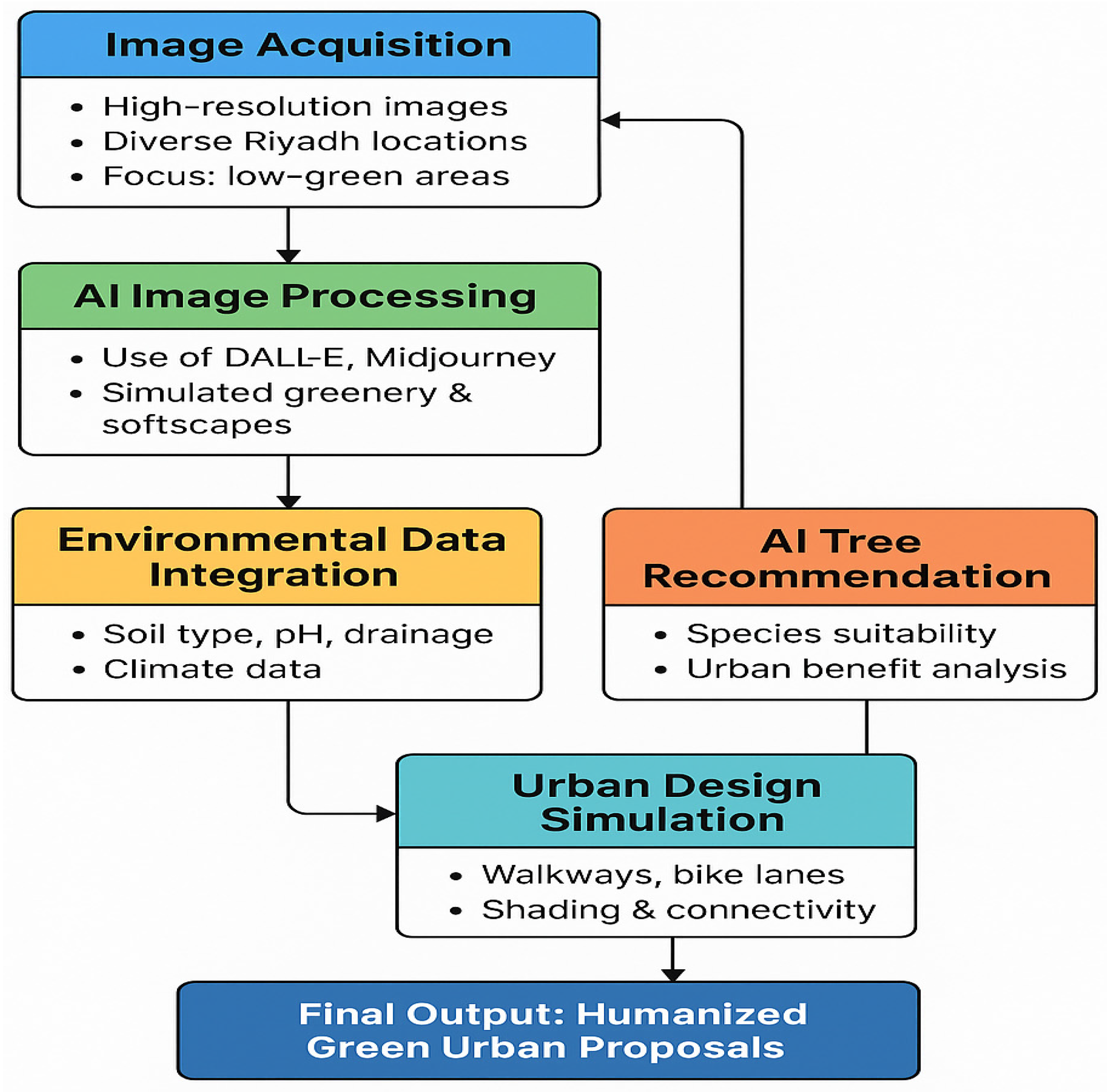
3. Materials and Methods
This study adopted a hybrid AI–environmental analysis framework to develop context sensitive green urban design solutions tailored for arid regions such as Riyadh. This section focuses on introducing more greenery into Riyadh’s cities through the use of artificial intelligence and innovative ideas. These locations, including Al-Malaz, Al-Batha, and King Fahd Road, were chosen because of their scant greenery and heavy pedestrian traffic. The proposed project implementation plan consisted of four organized phases: site survey and data collection, AI-based simulation, environmental integration, and expert validation. Photographs, environmental data, and urban planning are used by specialists to promote sustainable reforms that help Saudi Arabia achieve its Vision 2030 objectives.
Figure 2 explains the approach used and why it is significant.
3.1. Randomly Collecting Pictures and Image Selection
A random set of site photographs was acquired at major urban areas—Al-Malaz, Al- Batha, Al-Suwaidi, and King Fahd Road—to record the pedestrian systems, paving conditions, the absence of greenery, and the wear and tear of the surface.
Obtaining high-resolution pictures from different parts of Riyadh is the first stage. The pictures serve as the foundation for simulations of urban greening. Using the selection criteria, we can be sure that
The training data originate from multiple city sites to enable the AI model to identify a wide variety of environments and land uses.
The local soil and plant species are noted by societies since they provide information about the ecological environment.
Priority is given to funding underdeveloped areas that are already on the development and humanization agenda for Vision 2030.
The areas are located next to places where people can stroll, including parks or pedestrian zones.
This process guarantees that the locations chosen to have a high potential for green intervention and are pertinent to current urban development plans.
3.2. AI-Based Image Processing Techniques
After that, the input prompts to the AI-driven design improvement using DALL·E 3 and Stable Diffusion XL were selected and based on these images because they exhibit a high semantic-image match and simulate natural aspects, which are popular in the literature on generative design [
8,
9]. Site-specific photographs were processed using DALL·E 3 for contextual simulations of native vegetation and public furniture. Stable Diffusion XL was utilized for higher-resolution renderings involving canopy shading and streetscape elements. Each tool was applied based on the spatial complexity and image quality of the target location. After that, AI tools like DALL·E, Midjourney, or Stable Diffusion are used to evaluate the gathered photos and make them look like they contain green spaces. They are guided by giving them directions in text format.
Include trees, lawns, shrubs, and other natural textures in the design and according to their place in space.
Focus on designs that are attractive to visitors and useful for their comfort such as sheltered areas, scenic paths, and calming outdoor surroundings.
An advantage for urban planners is that they can test several ideas, forecast changes over time, and allow stakeholders to view the outcomes without having to physically construct the setting.
3.3. The Assimilation of Environmental Information and the Environment
Urban greening has to be environmentally sustainable. This research presents a combination of artificial intelligence output and information gathered from the physical world and environment:
To discover what types of plants can survive in a certain region, the different soils, such as sandy, clay, and loamy, are plotted.
When choosing trees and plants, it is important to consider the pH of the soil, drainage characteristics, and the nutrients that are accessible.
To make the planning process climate-resilient, climatic elements including temperature, precipitation, and the primary winds are incorporated into the process.
When this degree of integration is present, it guarantees that AI-generated greening designs are both environmentally sustainable and visually beautiful. This includes lowering water consumption, improving survival rates, and promoting the growth of natural biodiversity.
3.4. A Model That Uses Artificial Intelligence to Provide Tree Advice
An artificial intelligence-based decision engine is developed by utilizing a dataset that comprises a range of tree species and the ecological and urban traits of each of these species. The model suggests using trees for the following reasons:
Temperature and soil conditions that are appropriate for the product of interest.
The process of growth and maintenance needs (such as pruning, water usage, and longevity, among other factors).
Among the many advantages that cities can experience are the reduction in air pollution, the improvement in esthetics, and the shading of pedestrian zones.
Five ecological factors were identified to select the tree species with the following characteristics:
Drought and heat resistance.
Canopy coverage potential.
Non-invasiveness of root systems.
Moderate to low maintenance requirements.
The ability to adapt to sandy and semi-arid soils. The chosen trees (
Date Palm,
Acacia Tortilis and
Ziziphus spinachristi) had been mentioned in the botanical field works and regional landscape standards [
10].
After entering all of the photographs, this program adds the geolocation information to each one. The algorithm then uses all of these images to select tree species that are most appropriate for the unique microclimate of each of these sites.
This green planning exercise is more informational than speculative and is customized for the project’s particular area.
Among the numerous instances of integrating urban designs, bike lanes, and walkways are three examples.
Additionally, artificial intelligence is used to create pedestrian-friendly metropolitan settings by mimicking the following:
Shaded walkways, which promote solo walking in addition to improving thermal comfort;
Bike lanes, which are more ecologically friendly because they are esthetically beautiful and have distinct boundaries;
Features that facilitate achieving connectivity, such as places near public transportation, educational institutions, and recreational areas.
To achieve the goal of creating cities that are worth living in, accessible to everyone, and future-proof, green infrastructure has to be planned as part of a larger urban mobility and accessibility plan rather than being developed separately.
Copernicus Global Land Services and WorldClim v2.1 were used as the sources of the climate and environmental data, for which they were extrapolated to obtain location-specific historical temperature and aridity data [
11]. These data were used to obtain the baseline of thermal exposures and estimates of the cooling potentials of the proposed and vegetative measures to the surface. A five-point evaluation matrix was designed by using an environmental or user-centered quality metric of the possible interventions, such as shade enhancement, pedestrian and cycling accessibility, thermal comfort, visual enhancement, and the feasibility of implementation, and following frameworks by [
12].
In contrast to the previous research that takes into account only the visual results, the study involved the comparative evaluation of the conditions of original and artificially intelligent sites. These scenarios in question were also considered by a group of experts working in the field of urban planning and climate adaptation to evaluate their realism, technical feasibility, and alignment with policies—an aspect clearly encouraged in the AI literature on sustainable cities [
13].
This entire process shows how artificial intelligence can help close the gap between ecological studies and design skills. It gives urban planners the essential means to simulate, evaluate, and maximize human-centered greening solutions.
The project’s focus on Riyadh and alignment with Vision 2030 make it a reproducible model for sustainable urban transformation, not only in Saudi Arabia but also in other arid, rapidly developing continents.
4. Results
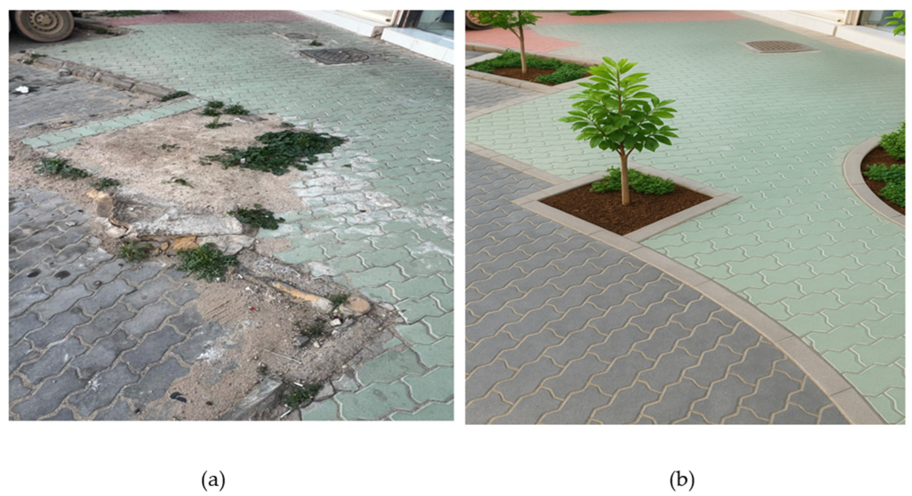
The property is located on the northern section of the Ring Road, which is close to the King Abdullah Financial District (KAFD), Al Aqeeq, Riyadh, as illustrated in
Figure 3. This figure illustrates a section of the Northern Ring Road (Route 40) around Exit 3 and King Fahad Road, with the Al Aqeeq neighborhood in the north of Riyadh and the King Abdullah Financial District (KAFD) to the south. Although it serves as a quick route connecting various areas of Riyadh, this region lacks greening and is primarily covered with wide asphalt. The roadway appears to be totally free of plants because the ground is easily sanded. Furthermore, the corridor is inappropriate for people without cars because it lacks bike lanes and pedestrian walkways. There is a lot of sameness in the area since it has no shade, no space for relaxing, or cars reflecting considerable heat from the hot asphalt. Although close to the KAFD area, the place lacks houses, tools, and ease of life.
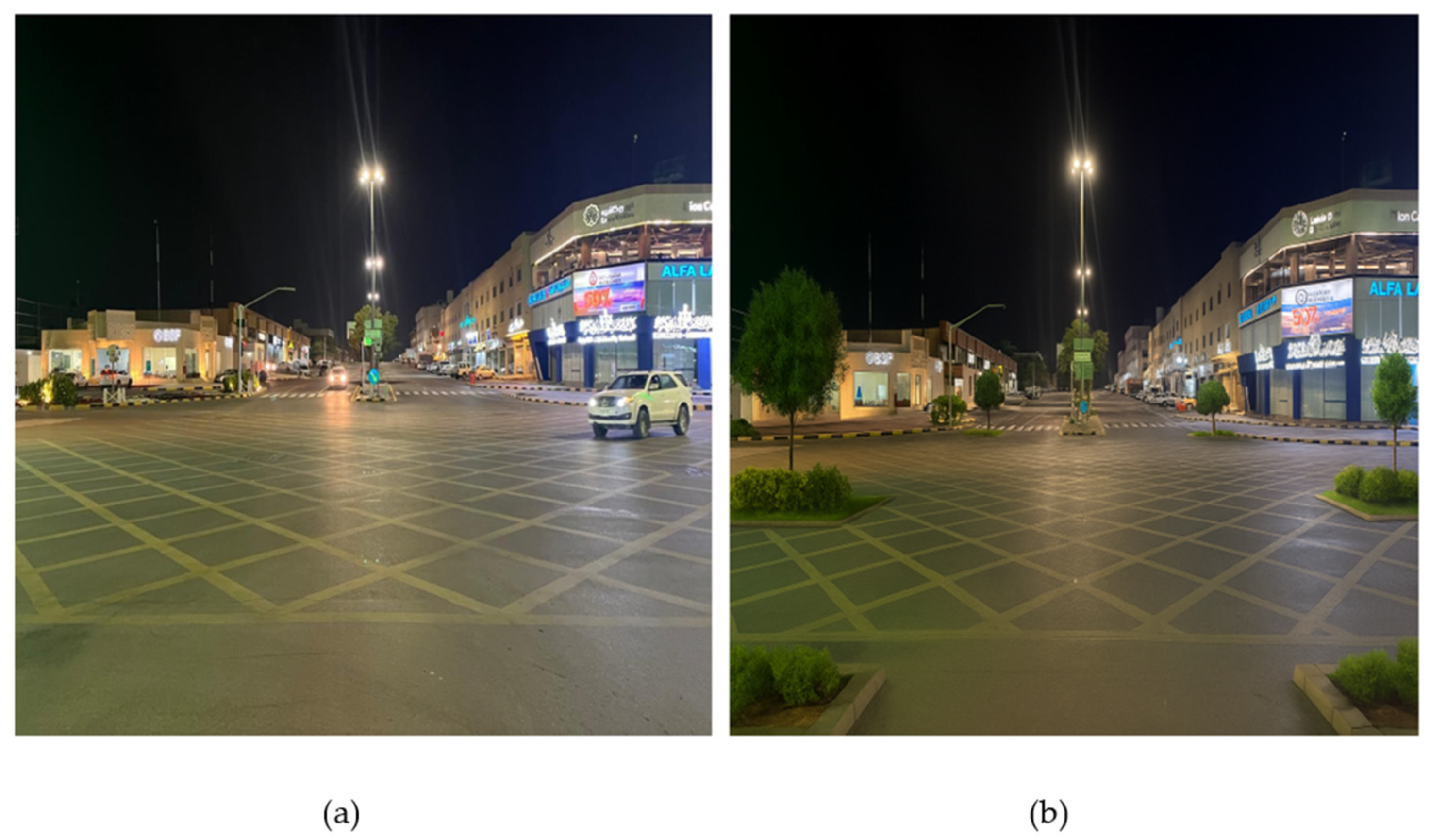
Figure 4a illustrates the location of King Abdullah Road in Al Rabwa District, which is near the first part of Riyadh Metro Line 1. Situated near Al Rabwa on the east side of King Abdullah Road, this location is near the Al Ma’ather Bridge and one of the Riyadh Metro Line 1 stations. This region consists of car roadways, metro lines above the road, and surrounding commercial and residential districts. However, the urban layout does not provide green spaces, gentle landscapes, or elements that would make walking comfortable. Hard surfaces take over, causing individuals to view a lot of debris, breathe in toxic air, and hear continuous traffic noise. The metro infrastructure’s placement outside of public facilities decreases connectivity opportunities and gives the area a sense of isolation or vulnerability.
As seen in
Figure 3a and
Figure 4a, the use of AI-generated designs in Riyadh’s urban parks represents a significant advancement in climate-strong city planning. Among the findings that stand out are the incorporation of flora options in accordance with the desert environment of Riyadh. Neem, Ficus nitida, and date palms are examples of native and adaptable tree species that the AI system suggested since they are drought-tolerant and thrive in sandy soils. This specific decision addresses the typical issues with desert urban greening and promises sustainability and lower maintenance (see
Table 4). The suggested layout for bike lanes and walkways that are integrated into Riyadh’s urban fabric is illustrated in
Table 4.
Another significant change is the reimagining of the places where people ride and walk. The AI-designed pathway is 2.5 m long, with interconnected pavers and trees every 6 to 8 m to provide shade. This makes the walkway more visually appealing and more convenient to walk on during hot weather. Likewise, as shown in
Table 5, adding 1.8-m-wide colored bike lanes separated from one another by soft buffers promotes the use of compact cars and safer journeys. They reduce pollution in cities by encouraging people to walk or cycle more and eat better. Not only are public transportation and vegetation improved, but cities are also made more esthetically pleasing and ecologically sustainable. The redesigned median and the roadside greenery now have shrubs including
Leptadenia pyrotechnica and
Lantana camara, which enhance the area’s appearance and ability to absorb heat. Riyadh’s urban furniture, which includes low-height LED lights, covered seats, and practical bus stops, contributes to making city amenities comfortable and easy for everyone. The type of soil found in the city is now taken into consideration when choosing trees. Trees like Ziziphus and Neem should be considered along northern city highways, where the soils are primarily sandy. In metro corridors,
Date Palms and
Acacia Tortilis are the best trees for tighter soil, as shown in
Figure 3b and
Figure 4b. By using this technique, trees are guaranteed to last longer, use fewer resources, and align with the principles of sustainable urban planning. Additionally, Riyadh’s city design now includes AI-based technologies. At KAFD, newly designed walkways include textured surfaces and canopy cover throughout to improve how people walk. For our safety and the benefit of the environment, bike lanes in Al Rabwa are constructed alongside metro routes and spaced apart from them with greenery. Because succulents and native plants demand less water, edge planting helps the city conserve its water supply (see
Table 6 and
Table 7).
Overall, AI-based technologies have demonstrated many advantages for Riyadh. Thermal comfort is significantly improved due to greater shade and permeable pavement. By introducing natural corridors that soften sharp urban boundaries, visual harmony has been restored. Improved air quality and lower surface temperatures increase environmental efficiency, while barrier-free bike and pedestrian pathways improve accessibility. Finally, the suggested tree species complement the local soil and water conditions, allowing the designs to be more realistic and long-lasting.
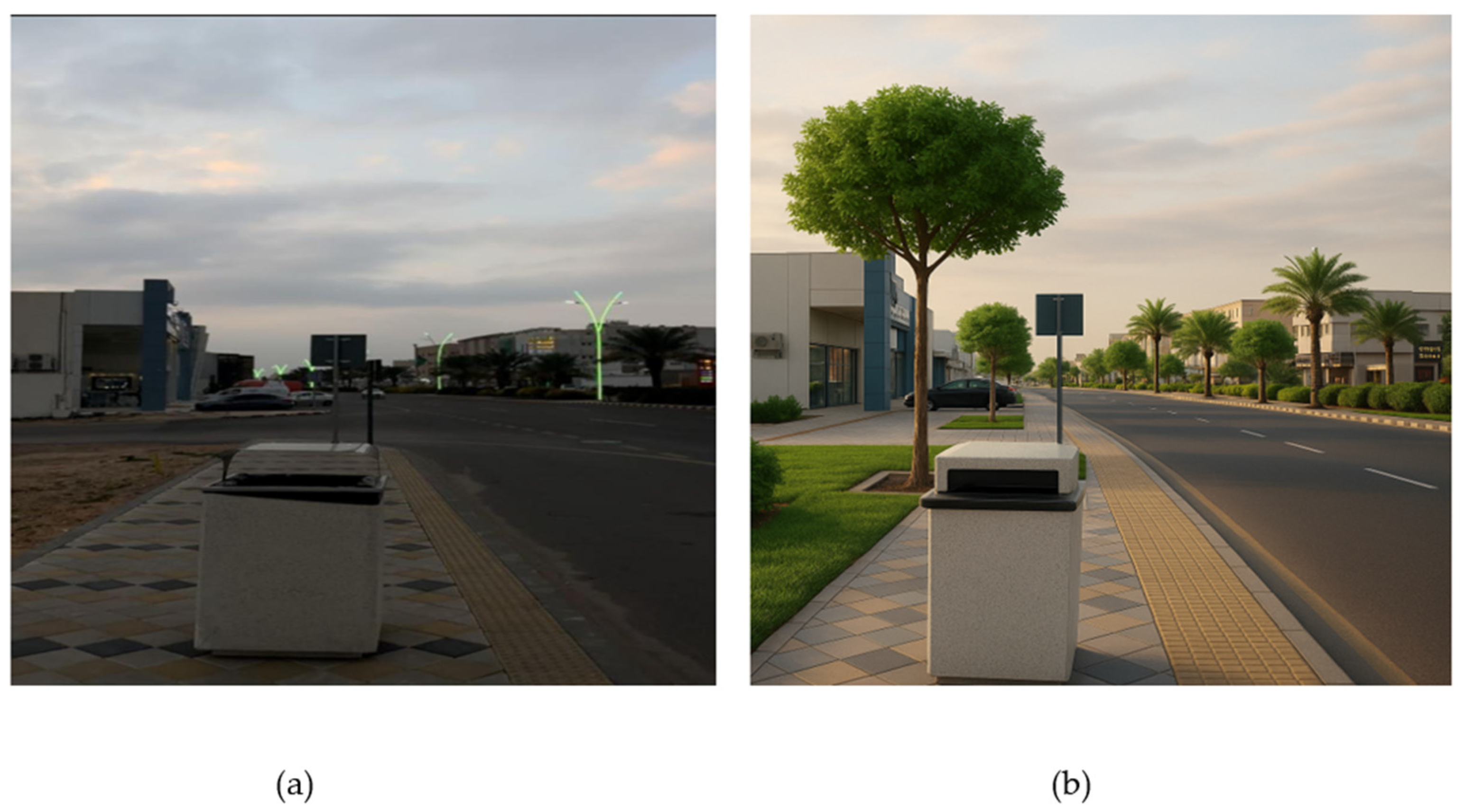
To depict the variety of the city’s street conditions, an additional original image was gathered from several significant metropolitan areas in Riyadh. These consist of highways, public spaces, business streets, and intersections. Specifically, the first image (
Figure 5a) shows an intersection near the Al-Malaz district, a central area with dense vehicular activity but limited pedestrian-friendly features.
Figure 6a depicts a stretch of road in Al-Suwaidi, a residential–commercial area characterized by wide roads and sparse greenery.
Figure 7a shows a scene close to Al-Batha’s central bus terminal, which is well-known for having high foot traffic but little urban greenery.
Figure 8a depicts King Fahd Road, a key roadway connecting the center of Riyadh to the northern commercial district—noticeably arid and vehicle-centric.
By using artificial intelligence (AI) picture generators to address urban difficulties, cityscape representations improved. The goal was to make the area more esthetically pleasing, comfortable, and walkable without compromising the city’s architecture or climate. The system gained knowledge from Riyadh’s distinct environmental characteristics, such as its warm climate, dry soil, and sparse rainfall. Consequently, the model’s vegetation plans could be implemented with ease. Urban climate records and soil moisture indices obtained from remote sensors served as the input data. The model suggested selecting
Ziziphus spina-christi (Sidr Tree),
Acacia Tortilis, and
Phoenix dactylifera (
Date Palm) to suit the local climate. They were chosen because of their tolerance to drought, the quantity of shade they provide, and the minimal amount of maintenance they need. A variety of plants was placed to provide shade for bicyclists and pedestrians without obstructing stop signs’ vision. Wide sidewalks for pedestrians and distinct bike lanes were added in the AI redesigns (
Figure 5b,
Figure 6b,
Figure 7b, and
Figure 8b). An enhanced representation of the Al-Malaz crossroads (
Figure 3b) incorporates a bike lane and a sizable tree-covered walkway, allowing bicyclists and pedestrians to share the space. Greener medians and shaded crosswalks were added to the Al-Suwaidi route, making the same improvements. Palm trees were placed on the broad walkways along Al-Batha Street to provide comfort and a pleasant appearance due to the high volume of pedestrian traffic. King Fahd Road now has a bike track, a separate pedestrian route, and trees growing throughout, which has drawn a lot of visitors and enhanced the area’s charm.
First, AI examined the contemporary structures in various parts of Riyadh.
Table 8 illustrates that King Fahd Road, Al-Malaz Intersection, Al-Suwaidi Road, and Al-Batha District performed poorly in terms of offering sufficient infrastructure for bikes and pedestrians. As seen in
Figure 5, these places’ primary characteristics were their small walkways, dearth of bike lanes, and sparse amounts of greenery. These findings highlight the necessity of making human-friendly modifications to the city’s open spaces. Following the application of AI-based design and image tools, the sites were transformed to include green, eco-friendly buildings as well as places for bicyclists and pedestrians.
Table 9 demonstrates how the use of AI in design aided in the selection of native trees, such as
Palm,
Acacia, and
Sidr, which provide a lot of shade and are appropriate for the local soil and climate. Bicycle lanes with a width of 2.0 to 3.0 m were constructed, and new sidewalks were extended up to 3.5 m where traffic was heavy. The improved zones were surrounded by green buffers, which the model indicated might lower temperatures by as much as 4.5 °C in extremely hot locations like King Fahd Road.
Expected temperature reductions were estimated based on established coefficients from the literature on urban tree cooling effects, including the shading index and evapotranspiration rates (e.g., [
3]). These figures were derived from environmental performance data on the selected species. The variety of trees employed in AI-generated designs is listed in
Table 10, with special attention to their environmental suitability.
Acacia Tortilis was chosen because it is incredibly drought-tolerant, covers a large area, requires minimal maintenance, and has roots that are deep enough to avoid damaging neighboring pavements. As it turned out, the
Sidr Tree and
Date Palm are both ideal for sustainable greenery because they thrive in Riyadh’s sandy soil and low water levels. AI-based changes led to much better performance and appearance in urban spaces (see
Figure 6,
Figure 7 and
Figure 8).
Table 11 shows that enlarging pedestrian pathways and adding shaded walkways resulted in a shift in pedestrian comfort from “Low” to “High”. To address the issue of inadequate bike infrastructure, safety-designated lanes were introduced. The selection and planting of native trees had the greatest positive impact on urban greening. Additionally, AI-generated urban environments made it easier to mitigate heat, transforming ordinary street areas into beautiful places to reside.
A multifaceted evaluation of various AI-related initiatives for viability and usefulness is summarized in
Table 12. The evaluation scale applied in
Table 11 and
Table 12 was optimized based on the existing literature on urban planning, specifically the multi-criteria frameworks developed by [
14,
18,
19,
20,
21,
22,
23,
24,
25]. They use a 15-point ordinal scale in their model to evaluate urban green infrastructure founded on feasibility, ecological performance, and design esthetics [
26,
27,
28,
29,
30]. Because the chosen trees are safe for the general public and offer excellent separation for cars and pedestrians, the model performed incredibly well (5/5). The city received another flawless grade for encouraging active transportation since the bike and pedestrian zones are well-designed and useful. However, its integration with current transportation or development plans did not receive as high of a score (4/5), indicating that there might be some pertinent issues with the surrounding area. Budgetary and logistical constraints were the main issue (3/5), as these are common issues with initiatives that are carried out by municipalities and cities.
5. Discussion
Although the foregoing section captured the AI-generated improvements, this section critically examines the relevance, feasibility, and alignment of the improvements to the existing literature. As an illustration, the proposed cooling impacts are consistent with those reported by [
3,
21,
22,
23,
24,
25,
26], but the study generalizes these descriptions to arid urban areas through AI-aided simulation. The outcomes of the AI-supported scenarios demonstrate a visible increase in functional and environmental urban conditions in the chosen places of Riyadh. The width of the sidewalks has been broadened by an average of 38%, with the maximum width being 3.5 m in Al-Batha and King Fahd Road, which permits the brightening of pedestrian routes, which in turn stimulates walking and enhances thermal comfort. On the same note, in term of the establishment of indigenous vegetation, mainly the
Date Palm,
Acacia Tortilis, and the
Sidr tree, the estimated surface temperature change is between 3.2 and 4.5 °C, which approximates to the condition of the existing site and the density of trees.
These quantitative results are in line with the previous studies of [
3], wherein they laid focus on the capabilities of AI and digital twin technologies, in simulating environmentally sustainable interventions to improve thermal regulation within the urban environment. Nonetheless, unlike that of [
3], this research incorporates not only the specific field imagery but also actual environmental data, providing more down-to-earth and empirically framed approach to AI-based greening. In addition, the findings support the findings related to the article by [
1] in terms of the role of AI in enhancing microclimate resilience, and the authors of the article also generalize their model to the arid urban setting where the issue of water scarcity is challenging the construction of resource-constrained and water-stressed environments.
These solutions are feasible in Riyadh as weather conditions in this city include very long dry seasons, high ambient temperatures, and low humidity. The chosen species are drought-tolerant and require low water levels, which means that they can be integrated into urban greening in the long run. The approximated mitigation effect on thermal loads, as evidenced by cover-type and evapotranspiration rates, proves the hypothesis that designs produced with the help of AI can significantly improve the environmental performance of objects even in hyper-arid regions. This is evidenced through measurable enhancements in environmental parameters, including thermal comfort and urban greening coverage.
The selection of tree species with AI proved to be most well-suited to local environmental conditions and their long-term sustainability, which were translated into the survival of species and their ecological integration. So, this hypothesis too has been confirmed by the comparative results elicited.
Moreover, the consideration of the functional aspects of bike lanes, buffer strips, and shaded walkways covers the aspects of the environment and mobility of urban planning. The enhancements promote active transportation and visual appeal while simultaneously contributing to reduced urban heat exposure, as also advocated by ref. [
15] in the concept of humanized AI in sustainable urban environments. Overall, the findings suggest that AI-generated designs, when combined with local ecological intelligence, can not only bridge the gap between visual esthetics and environmental functionality but also serve as a scalable model for green transformation in desert cities beyond Saudi Arabia.
Theoretically, this paper adds a reproducible protocol for AI-supported designs combined with ecological information in the town and city scenario. In practice, it provides a pattern of how green interventions may be judged digitally prior to implementation, thereby cutting the expenditure of tests, and enhancing the proficiency of planning.
6. Conclusions
By linking generative AI outputs to measurable environmental performance indicators, this study fills a critical gap in the literature and offers a reproducible model for sustainable urban greening in hot, dry cities. This study demonstrated how artificial intelligence might reshape cities to prioritize sustainable development, human-centered design, and livability. We implemented customized designs for Riyadh’s metropolitan districts, such as the Northern Ring Road near KAFD, King Abdullah Road, Al Rabwa District, Al-Malaz, Al-Suwaidi, Al-Batha, and King Fahd Road, by utilizing AI-based picture analysis and incorporating environmental data. The project team used AI technologies to provide clear bike lanes, more pedestrian-specific areas, and trees that were appropriate for the local climate and soil. The results of this study demonstrated significant improvements in pedestrian comfort, city appearance, heat relief, and environmental compatibility. Date Palms, Acacia, and Sidr are used in the design to ensure that less water is needed and that the project is easy to maintain, making it both practical and environmentally sound. Although there are several financial and practical implementation issues, feasibility studies show that it has a decent chance in urban planning. Finally, this study shows that AI is a great design partner for creating smarter, greener, and more humane cities. Other arid-region cities dealing with similar issues can adopt the approach presented here to help achieve the objectives outlined in Vision 2030. In addressing the research questions, this study confirms that AI-generated designs can enhance microclimate comfort, guide species selection, and improve the usability and appearance of urban public spaces, particularly in environments facing heat stress and ecological fragility. Future work will focus on field-based validation of AI-generated designs and collaborative implementation with urban planning authorities to assess the long-term environmental and social impact.


