
Temporal and Spatial Analysis of the Environmental State of the Valencia Plain Aquifer Area Using the Weighted Environmental Index (WEI)

 ,
,  and
and 
Abstract
1. Introduction and Objectives
1.1. Conversion of Agricultural Land into Urban Land
1.2. Urban Pressure in Natural Protected Areas
1.3. Objective of This Research
2. Materials and Methods
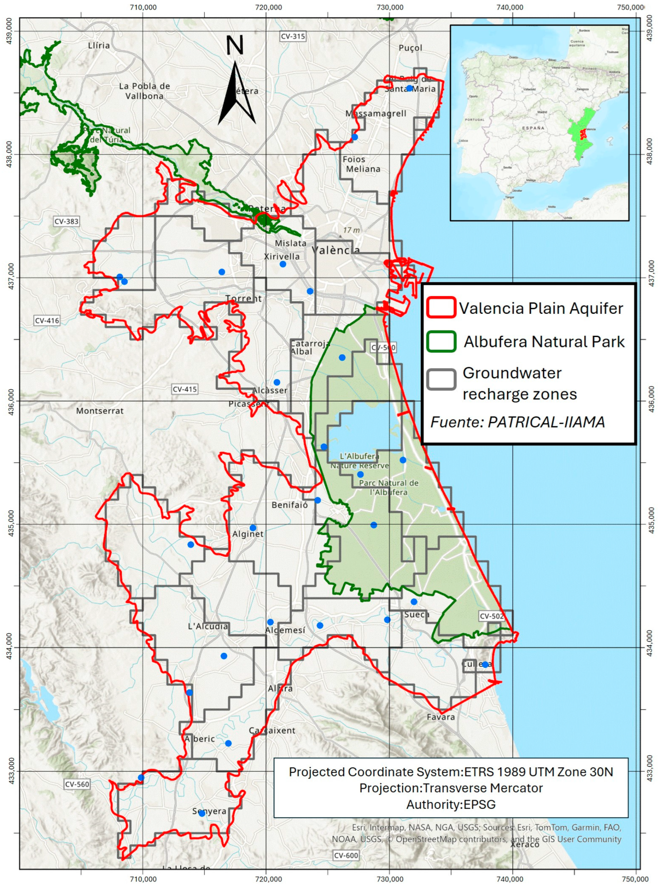
2.1. Study Area
2.2. The Weighted Environmental Index (WEI) Revisited
2.3. Adaptation of the Use of WEI to CORINE Land Cover (CLC) and World Settlement Footprint (WSF) Data
3. Results
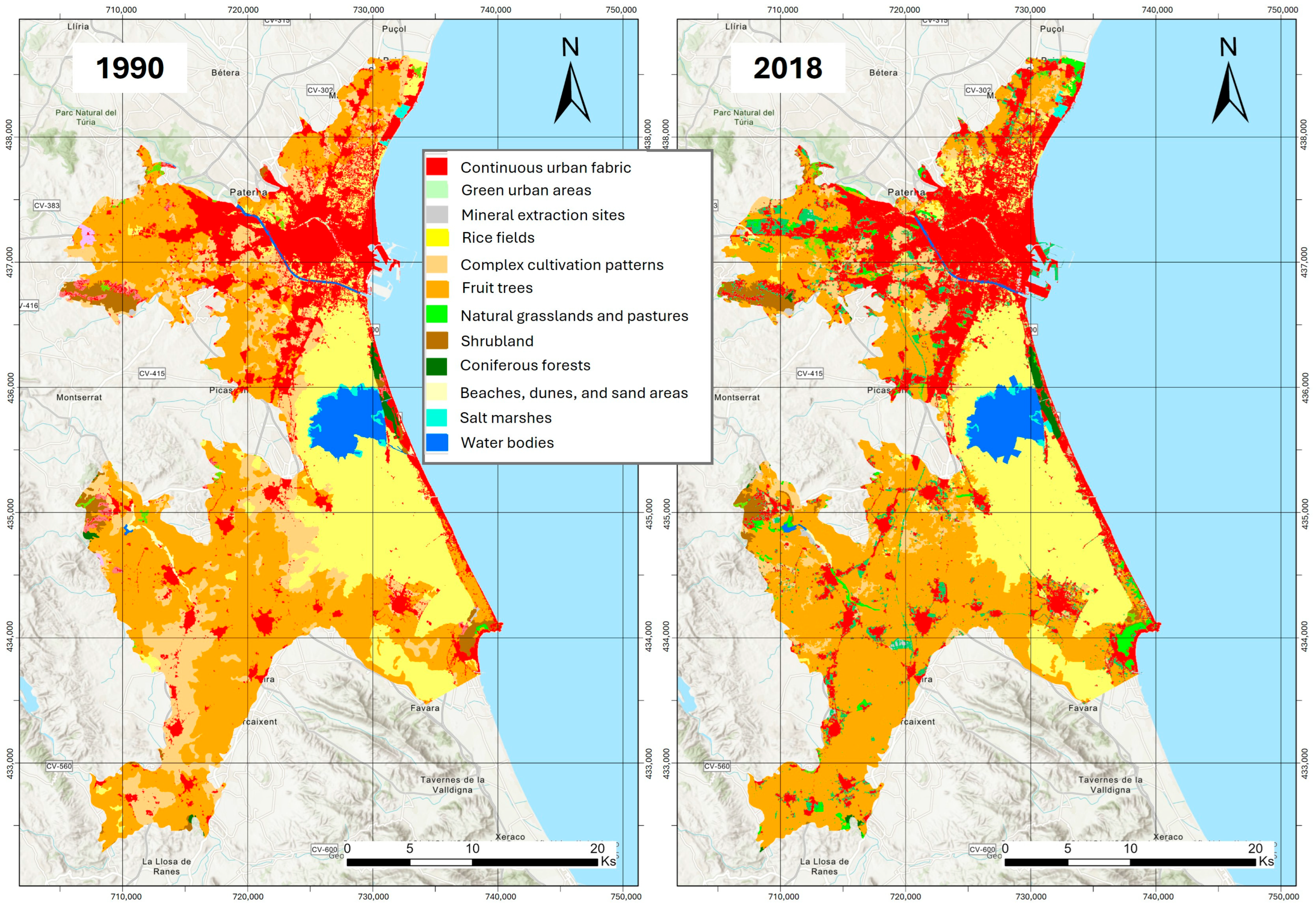
3.1. Soil Dynamics Between 1990 and 2018
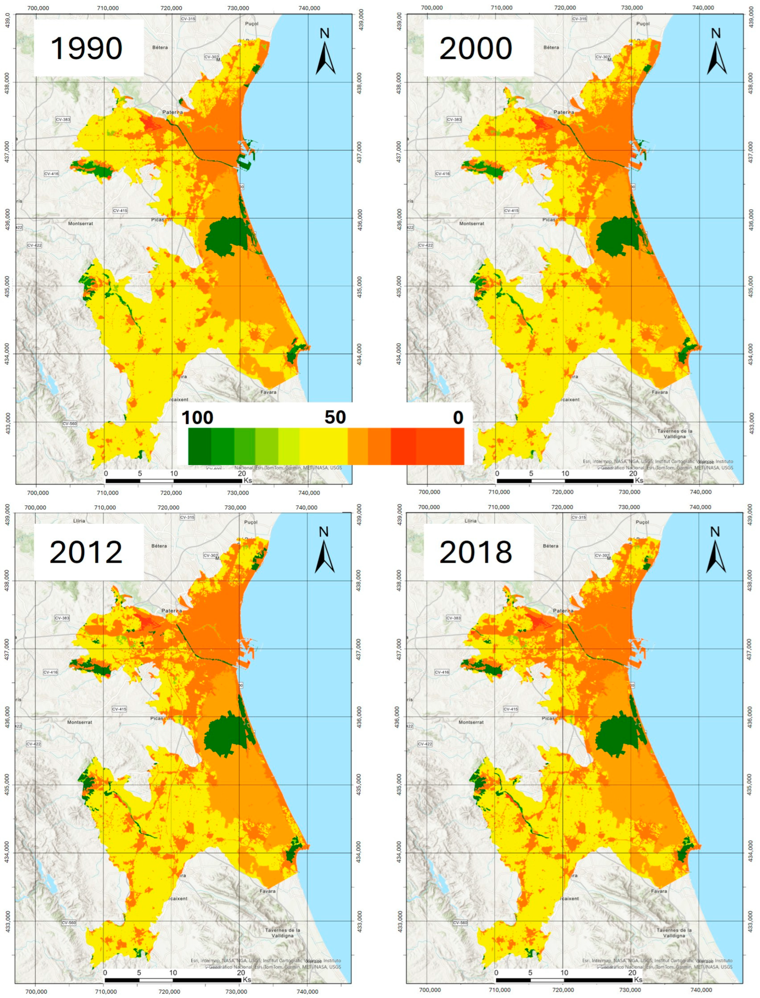
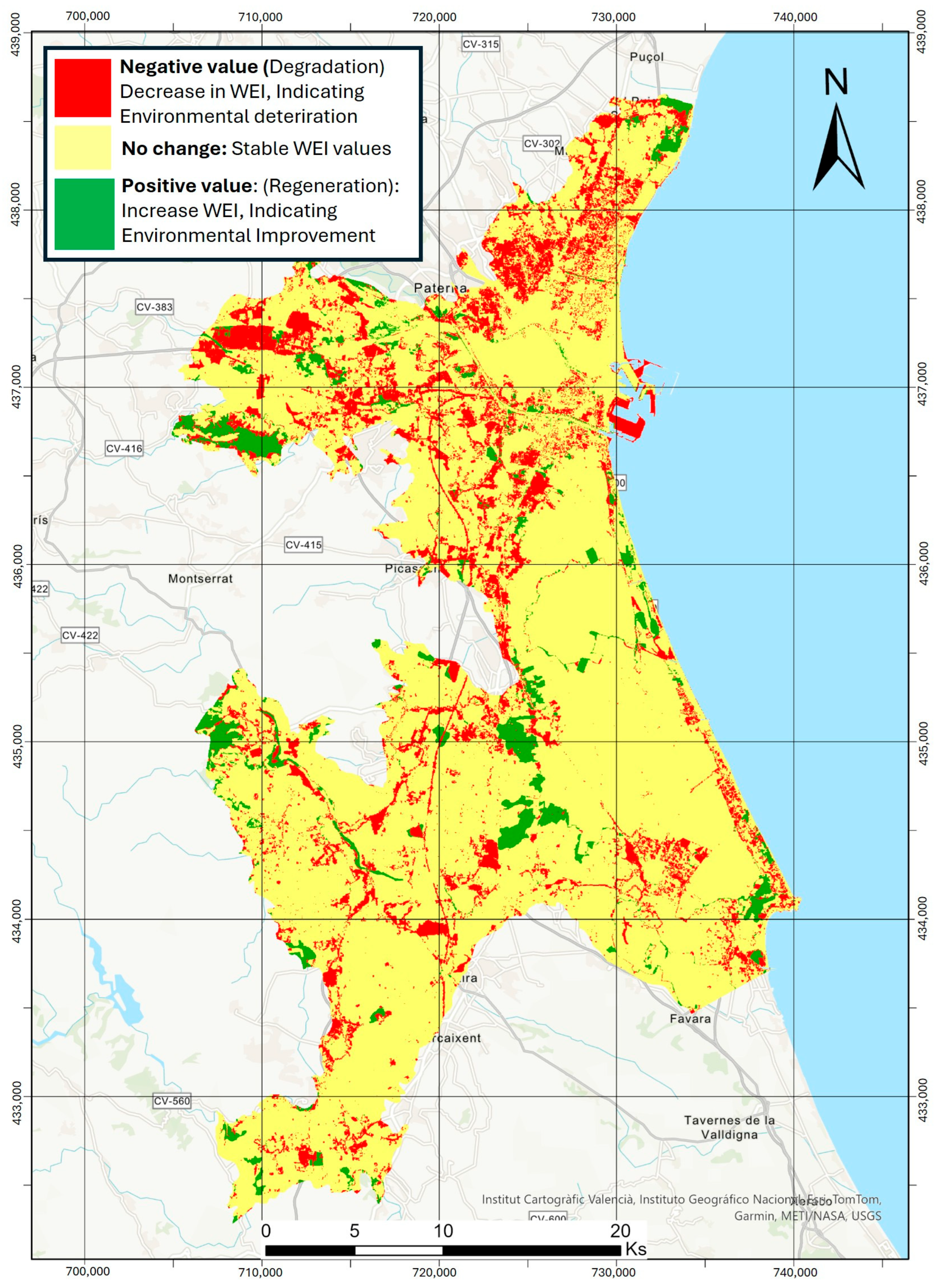
3.2. Dynamic of Soil Use Using the WEI Index
4. Discussion
4.1. Urban Expansion and the Decrease in the Environmental Value
4.2. The Reduction in Agricultural Areas and Its Environmental Implications
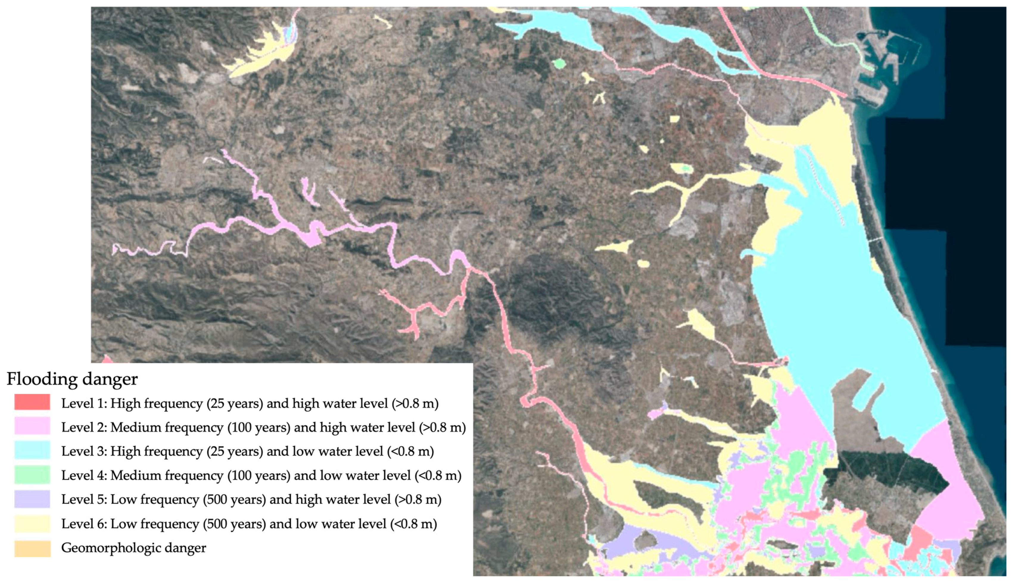
4.3. Evolution of the Environmental Value in the Albufera Natural Park
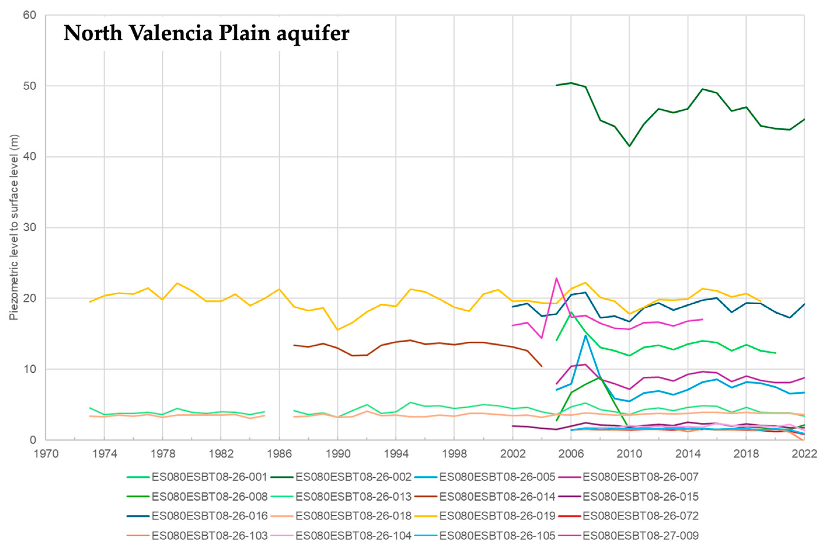
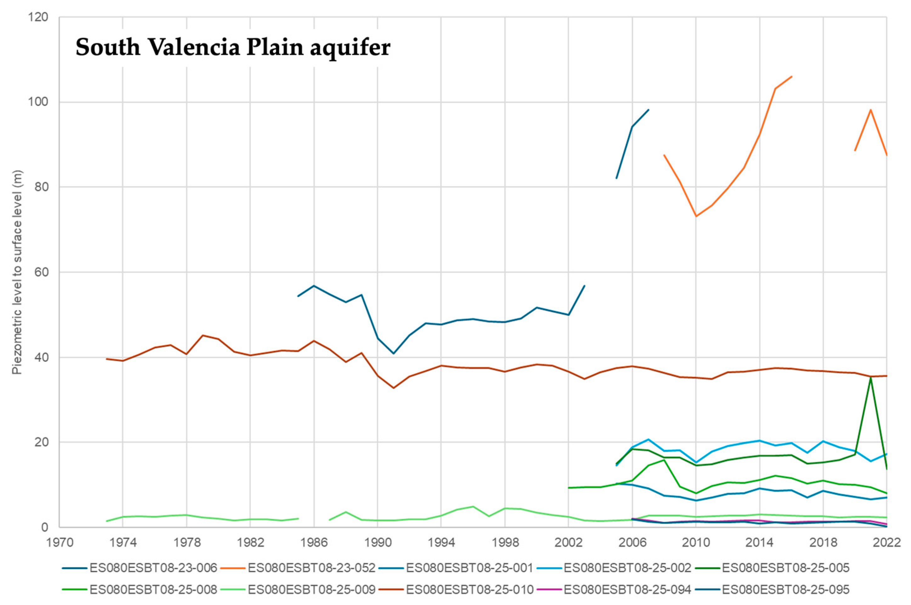
4.4. The WEI: Between the Visible and Invisible Dimensions of the Water Cycle
4.5. Opportunities for the Recovery and/or Maintenance of Ecosystem Functions
5. Conclusions
Supplementary Materials
Author Contributions
Funding
Institutional Review Board Statement
Informed Consent Statement
Data Availability Statement
Acknowledgments
Conflicts of Interest
References
- Chen, Z.; Dong, H. Exploring urban and agricultural land use planning. Results Eng. 2024, 24, 103093. [Google Scholar] [CrossRef]
- Hersperger, A.M.; Grădinaru, S.R.; Siedentop, S. Towards a better understanding of land conversion at the urban-rural interface: Planning intentions and the effectiveness of growth management. J. Land Use Sci. 2020, 15, 644–651. [Google Scholar] [CrossRef]
- Kocur-Bera, K.; Pszenny, A. Conversion of Agricultural Land for Urbanization Purposes: A Case Study of the Suburbs of the Capital of Warmia and Mazury, Poland. Remote Sens. 2020, 12, 2325. [Google Scholar] [CrossRef]
- Beckers, V.; Poelmans, L.; Van Rompaey, A.; Dendoncker, N. The impact of urbanization on agricultural dynamics: A case study in Belgium. J. Land Use Sci. 2020, 15, 626–643. [Google Scholar] [CrossRef]
- Prasada, I.Y.; Masyhuri, M. The Conversion of Agricultural Land in Urban Areas (Case Study of Pekalongan City, Central Java). AGRARIS J. Agribus. Rural. Dev. Res. 2019, 5, 112–118. [Google Scholar] [CrossRef]
- Radwan, T.M.; Blackburn, G.A.; Whyatt, J.D.; Atkinson, P.M. Dramatic Loss of Agricultural Land Due to Urban Expansion Threatens Food Security in the Nile Delta, Egypt. Remote Sens. 2019, 11, 332. [Google Scholar] [CrossRef]
- D’Amour, C.B.; Reitsma, F.; Baiocchi, G.; Barthel, S.; Güneralp, B.; Erb, K.-H.; Haberl, H.; Creutzig, F.; Seto, K.C. Future urban land expansion and implications for global croplands. Proc. Natl. Acad. Sci. USA 2017, 114, 8939–8944. [Google Scholar] [CrossRef]
- Ayele, A.; Tarekegn, K. The impact of urbanization expansion on agricultural land in Ethiopia: A review. Environ. Socio-Econ. Stud. 2020, 8, 73–80. [Google Scholar] [CrossRef]
- Khan, A.A.; Arshad, S.; Mohsin, M. Population Growth and Its Impact on Urban Expansion: A Case Study of Bahawalpur, Pakistan. Univers. J. Geosci. 2014, 2, 229–241. [Google Scholar] [CrossRef]
- Salazar-Galán, S.; Mascort-Albea, E.; Sánchez-Fuentes, D. Redefinición territorial pos COVID-19: Resiliencia frente a riesgos y desequilibrios en los modelos urbano-rurales. Rev. EURE Rev. Estud. Urbano Reg. 2022, 48, 1–9. [Google Scholar] [CrossRef]
- García-Vega, D.; Newbold, T. Assessing the effects of land use on biodiversity in the world’s drylands and Mediterranean environments. Biodivers. Conserv. 2020, 29, 393–408. [Google Scholar] [CrossRef]
- Fusco, J.; Walker, E.; Papaïx, J.; Debolini, M.; Bondeau, A.; Barnagaud, J.-Y. Land Use Changes Threaten Bird Taxonomic and Functional Diversity Across the Mediterranean Basin: A Spatial Analysis to Prioritize Monitoring for Conservation. Front. Ecol. Evol. 2021, 9, 612356. [Google Scholar] [CrossRef]
- Ferreira, C.S.S.; Seifollahi-Aghmiuni, S.; Destouni, G.; Ghajarnia, N.; Kalantari, Z. Soil degradation in the European Mediterranean region: Processes, status and consequences. Sci. Total Environ. 2022, 805, 150106. [Google Scholar] [CrossRef]
- Imbrenda, V.; Quaranta, G.; Salvia, R.; Egidi, G.; Salvati, L.; Prokopovà, M.; Coluzzi, R.; Lanfredi, M. Land degradation and metropolitan expansion in a peri-urban environment. Geomat. Nat. Hazards Risk 2021, 12, 1797–1818. [Google Scholar] [CrossRef]
- Kéfi, S.; Rietkerk, M.; Alados, C.; Pueyo, Y.; Papanastasis, V.P.; ElAich, A.; de Ruiter, P.C. Spatial vegetation patterns and imminent desertification in Mediterranean arid ecosystems. Nature 2007, 449, 213–217. [Google Scholar] [CrossRef]
- Salvia, R.; Egidi, G.; Vinci, S.; Salvati, L. Desertification Risk and Rural Development in Southern Europe: Permanent Assessment and Implications for Sustainable Land Management and Mitigation Policies. Land 2019, 8, 191. [Google Scholar] [CrossRef]
- Symeonakis, E.; Calvo-Cases, A.; Arnau-Rosalen, E. Land Use Change and Land Degradation in Southeastern Mediterranean Spain. Environ. Manag. 2007, 40, 80–94. [Google Scholar] [CrossRef]
- Tewolde, M.G.; Cabral, P. Urban sprawl analysis and modeling in Asmara, Eritrea. Remote Sens. 2011, 3, 2148–2165. [Google Scholar] [CrossRef]
- Jimoh, B.A.; Mustapha, D.; Bejide, O.I.; Ojeifo, D.O. Effects of Urban Encroachment on Rural Agricultural Land: A Case Study of Ibie-Nafe Community of Edo State, Nigeria. Asian Rev. Environ. Earth Sci. 2020, 7, 35–40. [Google Scholar] [CrossRef]
- Doygun, H. Effects of urban sprawl on agricultural land: A case study of Kahramanmaraş, Turkey. Environ. Monit. Assess. 2009, 158, 471–478. [Google Scholar] [CrossRef]
- Pahlevi, M.R.; Dinanti, D.; Subagiyo, A.; Qomariyah, Y.; Varo, J. The Relationship Between Community Characteristics and Urban Sprawl in Driyorejo Sub-District, Gresik Regency, Indonesia. Reg. Rural. Stud. 2023, 1, 22–31. [Google Scholar] [CrossRef]
- Prasada, I.Y.; Masyhuri, M. Factors Affecting Farmers’ Perception toward Agricultural Land Sustainability in Peri-Urban Areas of Pekalongan City. Caraka Tani J. Sustain. Agric. 2020, 35, 203–212. [Google Scholar] [CrossRef]
- Dadi, D.; Azadi, H.; Senbeta, F.; Abebe, K.; Taheri, F.; Stellmacher, T. Urban sprawl and its impacts on land use change in Central Ethiopia. Urban For. Urban Green. 2016, 16, 132–141. [Google Scholar] [CrossRef]
- Azadi, H.; Ho, P.; Hasfiati, L. Agricultural land conversion drivers: A comparison between less developed, developing and developed countries. Land Degrad. Dev. 2011, 22, 596–604. [Google Scholar] [CrossRef]
- Song, M.; Huntsinger, L.; Han, M. How does the Ecological Well-Being of Urban and Rural Residents Change with Rural-Urban Land Conversion? The Case of Hubei, China. Sustainability 2018, 10, 527. [Google Scholar] [CrossRef]
- Suwarlan, S.A.; Lai, L.Y.; Said, I. A review of agricultural and coastal cities in Indonesia in finding urban sprawl priority parameters. Modul 2022, 22, 91–99. [Google Scholar] [CrossRef]
- Robinson, L.; Newell, J.P.; Marzluff, J.M. Twenty-five years of sprawl in the Seattle region: Growth management responses and implications for conservation. Landsc. Urban Plan. 2005, 71, 51–72. [Google Scholar] [CrossRef]
- Kew, B.; Lee, B.D. Measuring sprawl across the urban rural continuum using an amalgamated sprawl index. Sustainability 2013, 5, 1806–1828. [Google Scholar] [CrossRef]
- Fernández-Nogueira, D.; Corbelle-Rico, E. Land use changes in Iberian Peninsula 1990–2012. Land 2018, 7, 99. [Google Scholar] [CrossRef]
- Kuemmerle, T.; Levers, C.; Erb, K.; Estel, S.; Jepsen, M.R.; Müller, D.; Plutzar, C.; Stürck, J.; Verkerk, P.J.; Verburg, P.H.; et al. Hotspots of land use change in Europe. Environ. Res. Lett. 2016, 11, 064020. [Google Scholar] [CrossRef]
- van der Sluis, T.; Pedroli, B.; Kristensen, S.B.P.; Cosor, G.L.; Pavlis, E. Changing land use intensity in Europe—Recent processes in selected case studies. Land Use Policy 2016, 57, 777–785. [Google Scholar] [CrossRef]
- Gardi, C.; Panagos, P.; Van Liedekerke, M.; Bosco, C.; De Brogniez, D. Land take and food security: Assessment of land take on the agricultural production in Europe. J. Environ. Plan. Manag. 2015, 58, 898–912. [Google Scholar] [CrossRef]
- Jiménez, V.; Campesino, A.-J. The Clandestine Transition towards an Unsustainable Urban Model in Extremadura, Spain. Urban Sci. 2018, 2, 103. [Google Scholar] [CrossRef]
- Gimmi, U.; Schmidt, S.L.; Hawbaker, T.J.; Alcántara, C.; Gafvert, U.; Radeloff, V.C. Increasing development in the surroundings of U.S. National Park Service holdings jeopardizes park effectiveness. J. Environ. Manag. 2011, 92, 229–239. [Google Scholar] [CrossRef]
- Seto, K.C.; Sánchez-Rodríguez, R.; Fragkias, M. The new geography of contemporary urbanization and the environment. Annu. Rev. Environ. Resour. 2010, 35, 167–194. [Google Scholar] [CrossRef]
- Vukomanovic, J.; Singh, K.K.; Vogler, J.B.; Meentemeyer, R.K. Protection status and proximity to public-private boundaries influence land use intensification near U.S. parks and protected areas. Conserv. Sci. Pract. 2020, 2, e190. [Google Scholar] [CrossRef]
- Guerra, C.A.; Rosa, I.M.D.; Pereira, H.M. Change versus stability: Are protected areas particularly pressured by global land cover change? Landsc. Ecol. 2019, 34, 2779–2790. [Google Scholar] [CrossRef]
- Luna, Á.; Romero-Vidal, P.; Hiraldo, F.; Tella, J.L. Cities may save some threatened species but not their ecological functions. PeerJ 2018, 6, e4908. [Google Scholar] [CrossRef]
- Tena, E.; Tellería, J.L. Modelling the distribution of bat activity areas for conservation in a Mediterranean mountain range. Anim. Conserv. 2022, 25, 65–76. [Google Scholar] [CrossRef]
- Marull, J.; Padró, R.; Cirera, J.; Giocoli, A.; Pons, M.; Tello, E. A socioecological integrated analysis of the Barcelona metropolitan agricultural landscapes. Ecosyst. Serv. 2021, 51, 101350. [Google Scholar] [CrossRef]
- Salvati, L.; Tombolini, I.; Ippolito, A.; Carlucci, M. Land quality and the city: Monitoring urban growth and land take in 76 Southern European metropolitan areas. Environ. Plan. B Urban Anal. City Sci. 2018, 45, 691–712. [Google Scholar] [CrossRef]
- Gómez, L.A.E.; González, J.A.G.; Navarro, J.M.M. Medium-sized Cities in Spain and Their Urban Areas within National Network. Urban Sci. 2019, 3, 5. [Google Scholar] [CrossRef]
- Rodrigo-Ilarri, J.; Romero, C.P.; Rodrigo-Clavero, M.E. Land Use/Land Cover Assessment over Time Using a New Weighted Environmental Index (WEI) Based on an Object-Oriented Model and GIS Data. Sustainability 2020, 12, 10234. [Google Scholar] [CrossRef]
- Marconcini, M.; Metz-Marconcini, A.; Esch, T.; Gorelick, N. Understanding current trends in global urbanisation—The world settlement footprint suite. GI_Forum 2021, 9, 33–38. [Google Scholar] [CrossRef]
- Vera-Herrera, L.; Romo, S.; Soria, J. How Agriculture, Connectivity and Water Management Can Affect Water Quality of a Mediterranean Coastal Wetland. Agronomy 2022, 12, 486. [Google Scholar] [CrossRef]
- Spadaro, C.; Vallerani, F. Re-imagining urban wetlands: Watery heritage and food policies in the Albufera de València. Shima 2023, 17, 10–31. [Google Scholar] [CrossRef]
- Sánchez-González, J.M.; Rodrigo-Ilarri, J.; Romero, C.P.; Rodrigo-Clavero, M.E. Environmental Sustainability Analysis of Land Use/Land Cover Change Using the WEI Index: Application to the Municipalities around the Doñana Area in Spain. Sustainability 2024, 16, 4241. [Google Scholar] [CrossRef]
- Rodrigo-Ilarri, J.; Rodrigo-Clavero, M.E.; Romero, C.P.; Suárez-Romero, P. Do Solid Waste Landfills Really Affect Land Use Change? Answers Using the Weighted Environmental Index (WEI). Remote Sens. 2022, 14, 5502. [Google Scholar] [CrossRef]
- Azevedo, S.; Barros, M. The application of the triple bottom line approach to sustainability assessment: The case study of the UK automotive supply chain. J. Ind. Eng. Manag. 2017, 10, 286–322. [Google Scholar] [CrossRef]
- Cattaneo, A.; Hellerstein, D.; Nickerson, C.; Myers, C. Balancing the Multiple Objectives of Conservation Programs. 2006. Available online: https://www.ers.usda.gov/ (accessed on 23 February 2025).
- Xu, H.; Xu, M.; Wang, H. Study on Rural Environmental Quality Comprehensive Evaluation Model. In Proceedings of the 2nd International Conference on Systems Engineering and Modeling (ICSEM 2013); Atlantis Press: Paris, France, 2013; pp. 396–401. [Google Scholar] [CrossRef]
- Hu, C.; Song, M.; Zhang, A. Dynamics of the eco-environmental quality in response to land use changes in rapidly urbanizing areas: A case study of Wuhan, China from 2000 to 2018. J. Geogr. Sci. 2023, 33, 245–265. [Google Scholar] [CrossRef]
- Zhang, T.; Gao, Y.; Li, C.; Xie, Z.; Chang, Y.; Zhang, B. How Human Activity Has Changed the Regional Habitat Quality in an Eco-Economic Zone: Evidence from Poyang Lake Eco-Economic Zone, China. Int. J. Environ. Res. Public Health 2020, 17, 6253. [Google Scholar] [CrossRef] [PubMed]
- Gill, S.E.; Handley, J.F.; Ennos, A.R.; Pauleit, S. Adapting Cities for Climate Change: The Role of the Green Infrastructure. Built Environ. 2007, 33, 115–133. [Google Scholar] [CrossRef]
- Mohamed, A.; DeClerck, F.; Verburg, P.H.; Obura, D.; Abrams, J.F.; Zafra-Calvo, N.; Rocha, J.; Estrada-Carmona, N.; Fremier, A.; Jones, S.K.; et al. Securing Nature’s Contributions to People requires at least 20%–25% (semi-)natural habitat in human-modified landscapes. One Earth 2024, 7, 59–71. [Google Scholar] [CrossRef]
- Van Der Ree, R.; Smith, D.J.; Grilo, C. The Ecological Effects of Linear Infrastructure and Traffic: Challenges and Opportunities of Rapid Global Growth. In Handbook of Road Ecology; Wiley: Hoboken, NJ, USA, 2015; pp. 1–9. [Google Scholar] [CrossRef]
- García-Ayllón, S. Predictive diagnosis of agricultural periurban areas based on territorial indicators: Comparative landscape trends of the so-called ‘Orchard of Europe’. Sustainability 2018, 10, 1820. [Google Scholar] [CrossRef]
- Cantos, J.O.; Hernández, M.H. Climate and Water on the Spanish Mediterranean Coast: Challenges for the Future; Springer Geography: Berlin/Heidelberg, Germany, 2021; pp. 121–143. [Google Scholar] [CrossRef]
- Sukopp, H.; Werner, P. Nature in Citie: A Report and Review of Studies and Experiments Concerning Ecology, Wildlife, and Nature Conservation in Urban and Suburban Areas; Council of Europe; Manhattan Pub. Co.: New York, NY, USA, 1982. [Google Scholar]
- Sadler, J.; Bates, A.; Hale, J.; James, P. Bringing cities alive: The importance of urban green spaces for people and biodiversity. In Urban Ecology; Cambridge University Press: Cambridge, MA, USA, 2013; pp. 230–260. [Google Scholar] [CrossRef]
- Gómez, F.; Tamarit, N.; Jabaloyes, J. Green zones, bioclimatics studies and human comfort in the future development of urban planning. Landsc. Urban Plan. 2001, 55, 151–161. [Google Scholar] [CrossRef]
- Gómez, F.; Jabaloyes, J.; Montero, L.; De Vicente, V.; Valcuende, M. Green Areas, the Most Significant Indicator of the Sustainability of Cities: Research on Their Utility for Urban Planning. J. Urban Plan. Dev. 2011, 137, 311–328. [Google Scholar] [CrossRef]
- Romero, J. Spanish Mediterranean Huertas: Theory and reality in the planning and management of peri-urban agriculture and cultural landscapes. In Sustainable Development and Planning VII; WIT Press: Southampton, UK, 2015; pp. 585–595. [Google Scholar] [CrossRef]
- Vallés-Planells, M.; Galiana, F.; Torrijos, I.D. Agricultural abandonment and resilience in a mediterranean periurban traditional agroecosystem: A landscape approach. Ecol. Soc. 2020, 25, 5. [Google Scholar] [CrossRef]
- de Molina, M.G.; Fernández, D.S.; Casado, G.G.; Infante-Amate, J.; Fernández, E.A.; Traver, J.V.; Ruiz, R.G. The Social Metabolism of Spanish Agriculture, 1900–2008; The Mediterranean Way Towards Industrialization: Florence, Italy, 2019. [Google Scholar] [CrossRef]
- Sanchis-Ibor, C.; Pulido-Velazquez, M.; de Palma, J.V.; García-Mollá, M. Water allocation in Spain. Legal framework, instruments and emerging debates. In Water Resources Allocation and Agriculture: Transitioning from Open to Regulated Access; IWA Publishing: London, UK, 2022; pp. 93–103. [Google Scholar] [CrossRef]
- Guzmán, G.I.; Fernández, D.S.; Aguilera, E.; Infante-Amate, J.; de Molina, M.G. The close relationship between biophysical degradation, ecosystem services and family farms decline in Spanish agriculture (1992–2017). Ecosyst. Serv. 2022, 56, 101456. [Google Scholar] [CrossRef]
- Molina, J.A.; Martín-Sanz, J.P.; Valverde-Asenjo, I.; Sánchez-Jiménez, A.; Quintana, J.R. Mediterranean grassland succession as an indicator of changes in ecosystem biodiversity and functionality. Biodivers. Conserv. 2023, 32, 95–118. [Google Scholar] [CrossRef]
- Vila-Traver, J.; Aguilera, E.; Infante-Amate, J.; de Molina, M.G. Climate change and industrialization as the main drivers of Spanish agriculture water stress. Sci. Total Environ. 2021, 760, 143399. [Google Scholar] [CrossRef]
- Pascual-Aguilar, J.; Andreu, V.; Gimeno-García, E.; Picó, Y. Current anthropogenic pressures on agro-ecological protected coastal wetlands. Sci. Total Environ. 2015, 503–504, 190–199. [Google Scholar] [CrossRef] [PubMed]
- Pascual-Aguilar, J.; Andreu, V.; Picó, Y. An environmental forensic procedure to analyse anthropogenic pressures of urban origin on surface water of protected coastal agro-environmental wetlands (L’Albufera de Valencia Natural Park, Spain). J. Hazard. Mater. 2013, 263, 214–223. [Google Scholar] [CrossRef] [PubMed]
- Marco, J.B. Hydrometeorological and Hydraulic Factors and Problems Related to Floods in Arid Regions of Spain. 1995. Available online: https://citeseerx.ist.psu.edu/document?repid=rep1&type=pdf&doi=e91a70f1c47de07718e34aeb5f8ac74cb11aa6ec (accessed on 15 April 2025).
- Belmonte, A.M.C.; Beltran, F.S.; Madrid, S. Flood events in Mediterranean ephemeral streams (ramblas) in Valencia region, Spain. Catena 2001, 45, 229–249. [Google Scholar] [CrossRef]
- Salazar-Galán, S.; García-Bartual, R.; Salinas, J.L.; Francés, F. A process-based flood frequency analysis within a trivariate statistical framework. Application to a semi-arid Mediterranean case study. J. Hydrol. 2021, 603, 127081. [Google Scholar] [CrossRef]
- Martínez-Gomariz, E.; Forero-Ortiz, E.; Russo, B.; Locatelli, L.; Guerrero-Hidalga, M.; Yubero, D.; Castan, S. A novel expert opinion-based approach to compute estimations of flood damage to property in dense urban environments. Barcelona case study. J. Hydrol. 2021, 598, 126244. [Google Scholar] [CrossRef]
- Olcina, J. Land Use Planning and Green Infrastructure: Tools for Natural Hazards Reduction. In Disaster Risk Reduction for Resilience: Disaster Risk Management Strategies; Springer International Publishing: Berlin/Heidelberg, Germany, 2022; pp. 129–146. [Google Scholar] [CrossRef]
- Salazar, S.; Francés, F.; Komma, J.; Blume, T.; Francke, T.; Bronstert, A.; Blöschl, G. A comparative analysis of the effectiveness of flood management measures based on the concept of ‘retaining water in the landscape’ in different European hydro-climatic regions. Nat. Hazards Earth Syst. Sci. 2012, 12, 3287–3306. [Google Scholar] [CrossRef]
- Generalitat Valenciana. Plan de Acción Territorial de Carácter Sectorial Sobre Prevención del Riesgo de Inundación en la Comunitat Valenciana (PATRICOVA). 2015. Available online: https://mediambient.gva.es/es/web/planificacion-territorial-e-infraestructura-verde/patricova-docs (accessed on 14 June 2025). (In Spanish).

| Code | Description | F1 | F2 | F3 | F4 | F5 | WEIk | |
|---|---|---|---|---|---|---|---|---|
| 1. Artificial surfaces | 111 | Continuous urban fabric | 30 | 30 | 10 | 20 | 10 | 20 |
| 112 | Discontinuous urban fabric | 30 | 30 | 10 | 20 | 10 | 20 | |
| 121 | Industrial or commercial units | 30 | 30 | 10 | 20 | 10 | 20 | |
| 122 | Road and rail networks and associated land | 20 | 40 | 20 | 15 | 5 | 20 | |
| 123 | Port areas | 10 | 10 | 10 | 10 | 10 | 10 | |
| 124 | Airports | 10 | 10 | 10 | 10 | 10 | 10 | |
| 131 | Mineral extraction sites | 10 | 10 | 10 | 10 | 10 | 10 | |
| 132 | Dump sites | 0 | 0 | 0 | 0 | 0 | 0 | |
| 133 | Construction sites | 30 | 30 | 10 | 20 | 10 | 20 | |
| 141 | Green urban areas | 60 | 65 | 70 | 80 | 75 | 70 | |
| 142 | Sport and leisure facilities | 20 | 20 | 20 | 20 | 20 | 20 | |
| 2. Agricultural areas | 211 | Non-irrigated arable land | 60 | 65 | 40 | 50 | 50 | 53 |
| 212 | Permanently irrigated land | 60 | 65 | 80 | 75 | 70 | 70 | |
| 213 | Rice fields | 60 | 10 | 80 | 45 | 55 | 50 | |
| 221 | Vineyards | 60 | 65 | 80 | 75 | 70 | 70 | |
| 222 | Fruit trees and berry plantations | 60 | 65 | 80 | 75 | 70 | 70 | |
| 223 | Olive groves | 60 | 65 | 80 | 75 | 70 | 70 | |
| 231 | Pastures | 80 | 80 | 90 | 100 | 100 | 90 | |
| 241 | Annual crops associated with permanent crops | 60 | 37 | 80 | 60 | 62 | 60 | |
| 242 | Complex cultivation patterns | 47 | 59 | 70 | 66 | 57 | 60 | |
| 243 | Land principally occupied by agriculture | 75 | 75 | 75 | 72 | 72 | 74 | |
| 244 | Agro-forestry areas | 90 | 90 | 100 | 100 | 85 | 93 | |
| 3. Forest and semi-natural areas | 311 | Broad-leaved forest | 100 | 100 | 100 | 100 | 100 | 100 |
| 312 | Coniferous forest | 100 | 100 | 100 | 100 | 100 | 100 | |
| 313 | Mixed forest | 100 | 100 | 100 | 100 | 100 | 100 | |
| 321 | Natural grasslands | 80 | 80 | 80 | 80 | 80 | 80 | |
| 322 | Moors and heathland | 100 | 100 | 100 | 100 | 100 | 100 | |
| 323 | Sclerophyllous vegetation | 100 | 100 | 100 | 100 | 100 | 100 | |
| 324 | Transitional woodland–shrub | 70 | 70 | 70 | 70 | 70 | 70 | |
| 331 | Beaches, dunes, sands | 100 | 100 | 50 | 100 | 100 | 90 | |
| 332 | Bare rocks | 80 | 50 | 30 | 30 | 60 | 50 | |
| 333 | Sparsely vegetated areas | 70 | 70 | 70 | 70 | 70 | 70 | |
| 334 | Burnt areas | 0 | 50 | 0 | 0 | 0 | 10 | |
| 335 | Glaciers and perpetual snow | 100 | 100 | 100 | 100 | 100 | 100 | |
| 4. Wetlands | 411 | Inland marshes | 90 | 60 | 70 | 90 | 90 | 80 |
| 412 | Peat bogs | 100 | 100 | 100 | 100 | 100 | 100 | |
| 421 | Salt marshes | 80 | 50 | 30 | 80 | 60 | 60 | |
| 422 | Saline areas | 90 | 30 | 40 | 80 | 60 | 60 | |
| 5. Water bodies | 423 | Intertidal flats | 80 | 50 | 30 | 80 | 60 | 60 |
| 511 | Water courses | 100 | 100 | 100 | 100 | 100 | 100 | |
| 512 | Water bodies | 100 | 100 | 100 | 100 | 100 | 100 | |
| 521 | Coastal lagoons | 100 | 100 | 100 | 100 | 100 | 100 | |
| 522 | Estuaries | 80 | 50 | 30 | 80 | 60 | 60 | |
| 523 | Seas and oceans | 100 | 100 | 100 | 100 | 100 | 100 |
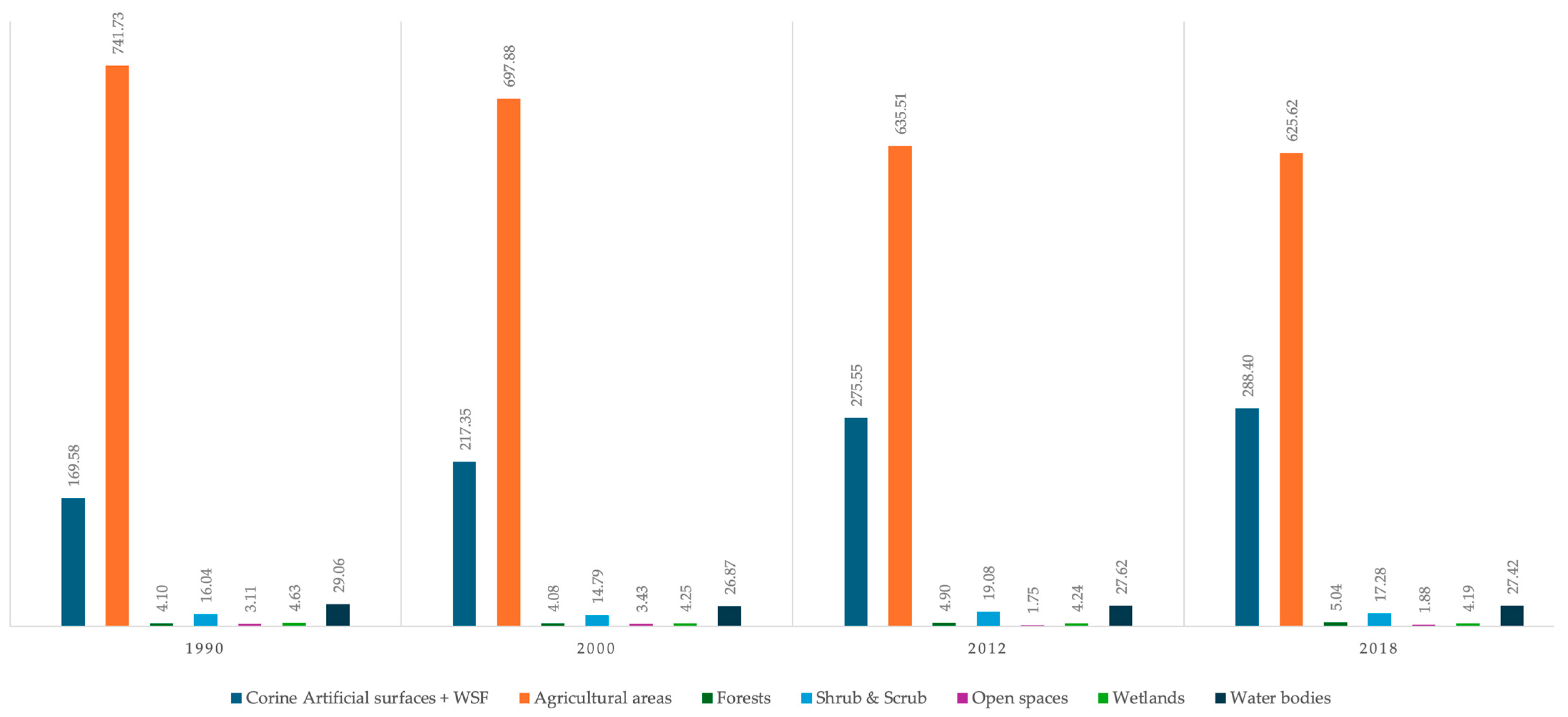
| Description | 1990 (km2) | 2000 (km2) | Variation 1990–2000 | 2012 (km2) | Variation 2000–2012 | 2018 (km2) | Variation 2012–2018 | Variation 1990–2018 |
|---|---|---|---|---|---|---|---|---|
| Urban | 168.97 | 216.78 | +47.81 | 274.82 | +58.04 | 287.56 | +12.74 | +118.59 |
| Crops | 741.73 | 697.88 | −43.85 | 628.58 | −69.30 | 618.44 | −10.14 | −123.29 |
| Trees | 4.10 | 4.08 | −0.02 | 4.90 | +0.82 | 5.04 | +0.14 | +0.94 |
| Grass | 0.33 | 0.41 | +0.08 | 7.01 | +6.60 | 6.10 | −0.91 | +5.77 |
| Shrubs and Scrub | 15.72 | 14.39 | −1.33 | 12.07 | −2.32 | 11.18 | −0.89 | −4.54 |
| Bare ground | 3.11 | 3.43 | +0.32 | 1.75 | −1.68 | 1.88 | +0.13 | −1.23 |
| Water | 33.69 | 31.12 | −2.57 | 31.86 | +0.74 | 31.61 | −0.25 | −2.08 |
| Year | Total WEI | Area (km2) | |||||
|---|---|---|---|---|---|---|---|
| Urban | Irrigated Crops | Rainfed Crops | Trees | Natural Pastures | Bare Ground | ||
| 1990 | 44.80 | 168.97 | 589.87 | 151.86 | 4.10 | 0.33 | 3.11 |
| 2000 | 43.23 | 216.78 | 572.32 | 125.56 | 4.08 | 0.41 | 3.43 |
| 2012 | 41.15 | 274.82 | 566.92 | 61.66 | 4.90 | 7.01 | 1.75 |
| 2018 | 40.68 | 287.56 | 563.69 | 54.75 | 5.04 | 6.10 | 1.88 |
| Category (km2) | 1990 | 2000 | 2012 | 2018 |
|---|---|---|---|---|
| Urban areas | 168.97 | 216.78 | 274.82 | 287.56 |
| Crops | 741.7 | 697.88 | 635.51 | 625.62 |
| Natural and semi-natural | 57.56 | 54.00 | 58.31 | 56.65 |
| Natural/Semi-natural vs. Valencia Plain | 6.3% | 5.9% | 6.4% | 6.2% |
| Natural/Semi-natural vs. Urban | 34.1% | 24.9% | 21.2% | 19.7% |
| Natural/Semi-natural vs. Crops | 7.8% | 7.7% | 9.2% | 9.1% |
| Zone | Urban (km2) | Irrigated Crops (km2) | Rainfed Crops (km2) | Recharge (m) |
|---|---|---|---|---|
| 8135010 | 2.28 | −2.94 | 0.2 | −0.06 |
| 8135022 | 6.3 | −3.15 | −4.21 | −0.01 |
| 8135026 | 13.57 | −10.03 | −3.4 | −0.05 |
| 8135040 | 7.28 | −5.72 | −1.69 | −0.04 |
| 8135050 | 6.45 | −4.93 | −1.98 | −0.05 |
| 8135060 | 7.49 | −0.5 | −7.17 | −0.01 |
| 8135070 | 4.47 | −4.25 | 0.47 | −0.04 |
| 8135080 | 7.02 | −3.73 | −3.12 | −0.04 |
| 8135090 | 10.19 | −5.72 | −6.04 | −0.05 |
| 8135094 | −0.01 | −0.61 | −0.01 | −0.03 |
| 8135504 | 0.42 | −1.26 | 0.33 | −0.04 |
| 8135510 | 4.34 | 8.76 | −13.84 | −0.27 |
| 8135520 | 3.01 | −3.97 | −0.28 | −0.21 |
| 8135522 | 5.75 | 15.42 | −21.17 | −0.25 |
| 8135526 | 4.54 | −2.44 | −2.47 | −0.31 |
| 8135530 | 3.82 | 2.4 | −6.55 | −0.37 |
| 8135540 | 7.53 | 6.25 | −13.79 | −0.27 |
| 8135550 | 3.02 | −2.39 | −0.63 | −0.33 |
| 8135560 | 2.08 | 1.11 | −3.45 | −0.08 |
| 8135570 | 2.52 | −0.27 | −2.27 | −0.17 |
| 8135580 | 5.78 | −5.16 | −1.28 | −0.11 |
Disclaimer/Publisher’s Note: The statements, opinions and data contained in all publications are solely those of the individual author(s) and contributor(s) and not of MDPI and/or the editor(s). MDPI and/or the editor(s) disclaim responsibility for any injury to people or property resulting from any ideas, methods, instructions or products referred to in the content. |
© 2025 by the authors. Licensee MDPI, Basel, Switzerland. This article is an open access article distributed under the terms and conditions of the Creative Commons Attribution (CC BY) license (https://creativecommons.org/licenses/by/4.0/).
Share and Cite
Rodrigo-Ilarri, J.; Romero-Hernández, C.P.; Salazar-Galán, S.; Rodrigo-Clavero, M.-E. Temporal and Spatial Analysis of the Environmental State of the Valencia Plain Aquifer Area Using the Weighted Environmental Index (WEI). Sustainability 2025, 17, 5921. https://doi.org/10.3390/su17135921
Rodrigo-Ilarri J, Romero-Hernández CP, Salazar-Galán S, Rodrigo-Clavero M-E. Temporal and Spatial Analysis of the Environmental State of the Valencia Plain Aquifer Area Using the Weighted Environmental Index (WEI). Sustainability. 2025; 17(13):5921. https://doi.org/10.3390/su17135921
Chicago/Turabian StyleRodrigo-Ilarri, Javier, Claudia P. Romero-Hernández, Sergio Salazar-Galán, and María-Elena Rodrigo-Clavero. 2025. "Temporal and Spatial Analysis of the Environmental State of the Valencia Plain Aquifer Area Using the Weighted Environmental Index (WEI)" Sustainability 17, no. 13: 5921. https://doi.org/10.3390/su17135921
APA StyleRodrigo-Ilarri, J., Romero-Hernández, C. P., Salazar-Galán, S., & Rodrigo-Clavero, M.-E. (2025). Temporal and Spatial Analysis of the Environmental State of the Valencia Plain Aquifer Area Using the Weighted Environmental Index (WEI). Sustainability, 17(13), 5921. https://doi.org/10.3390/su17135921