
Consolidating the Polish Land Use Cadastral Register with the Austrian and German Systems: An Extension of the Polish Cadastre Model Towards Sustainable Land Management


Abstract
1. Introduction
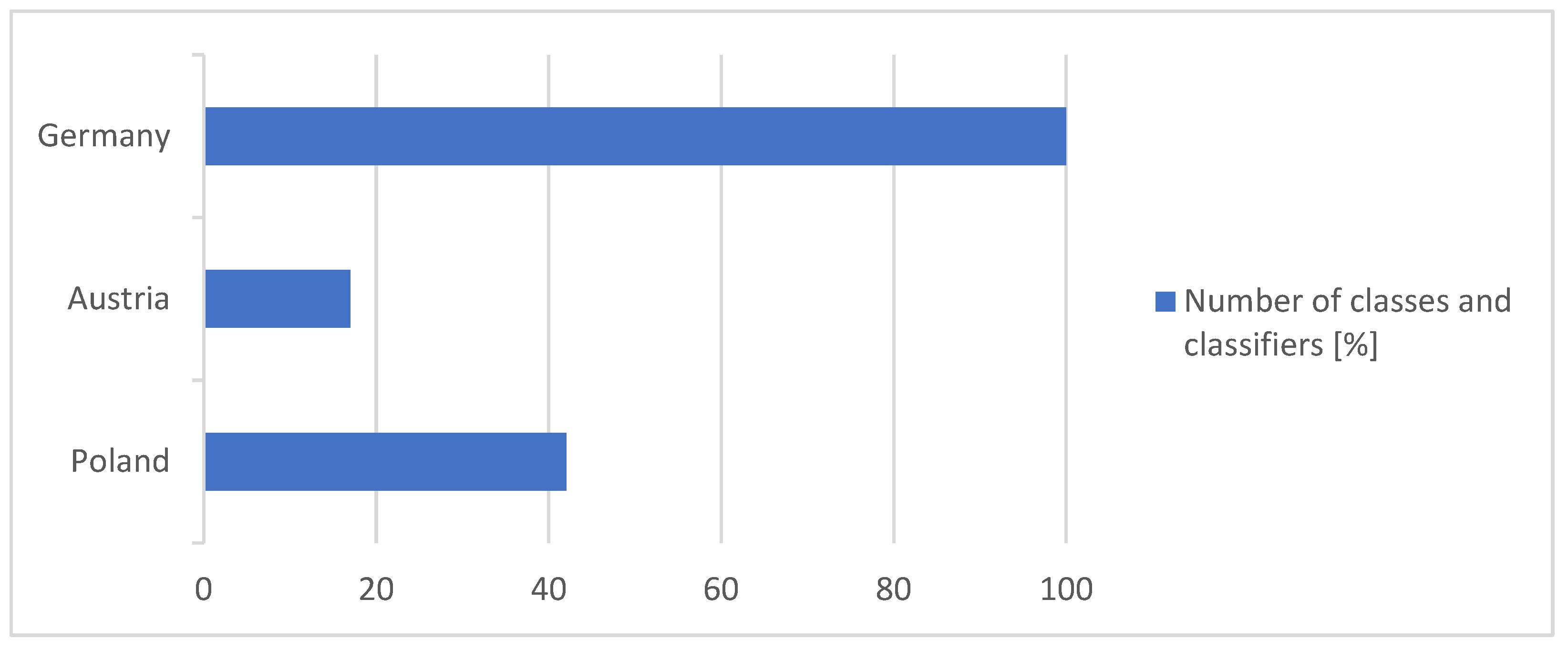
- How detailed are land use registrations in the studied countries regarding the classifiers distinguished within land use classes?
- Based on an analysis of how land use is registered in other countries, is it possible to propose a new land use class of a specific functional nature related to the Polish tax system?
2. Materials and Methods
2.1. The Tax System in Poland
2.2. Land Use Registration
- Building land—areas used for construction and primarily designated for such use;
- Land used for agricultural purposes—including arable land, meadows, and pastures;
- Gardens—land used for horticultural activities or primarily for recreation and leisure;
- Vineyards—land dedicated to viticulture;
- Alps—land used for mountain farming;
- Forests—land designated for forestry;
- Waters—land covered with running or stagnant water bodies, including adjoining slopes, embankments, swamps, and reed-covered areas;
- Other types of land.
- Built-up areas,
- Transportation areas,
- Agricultural and forest land,
- Land under water.
3. Examination of Records in Cadastral Registers
3.1. Land Use in Austria
- Storage areas, understood as land occupied by warehouse buildings.
- Business premises.
- Parking lots at shopping centers, recreational facilities, and other parking areas.
- Harbor facilities.
- Airport facilities.
- Waste disposal sites.
3.2. Germany—State of Brandenburg
- Water supply system.
- Nuclear power plant.
- Power system using solar energy.
- Power system using wind energy.
- Power system—combustion.
- Supply facility—coal.
- Hydroelectric power plant.
- Nuclear power plant.
- Power plant using solar energy.
- Wind power plant.
- Power plant using combustion.
- Coal-fired power plant.
- Thermal power plant—nuclear power plant.
- Heating installation using solar energy.
- Heating installation using combustion.
- Coal-fired heating plant.
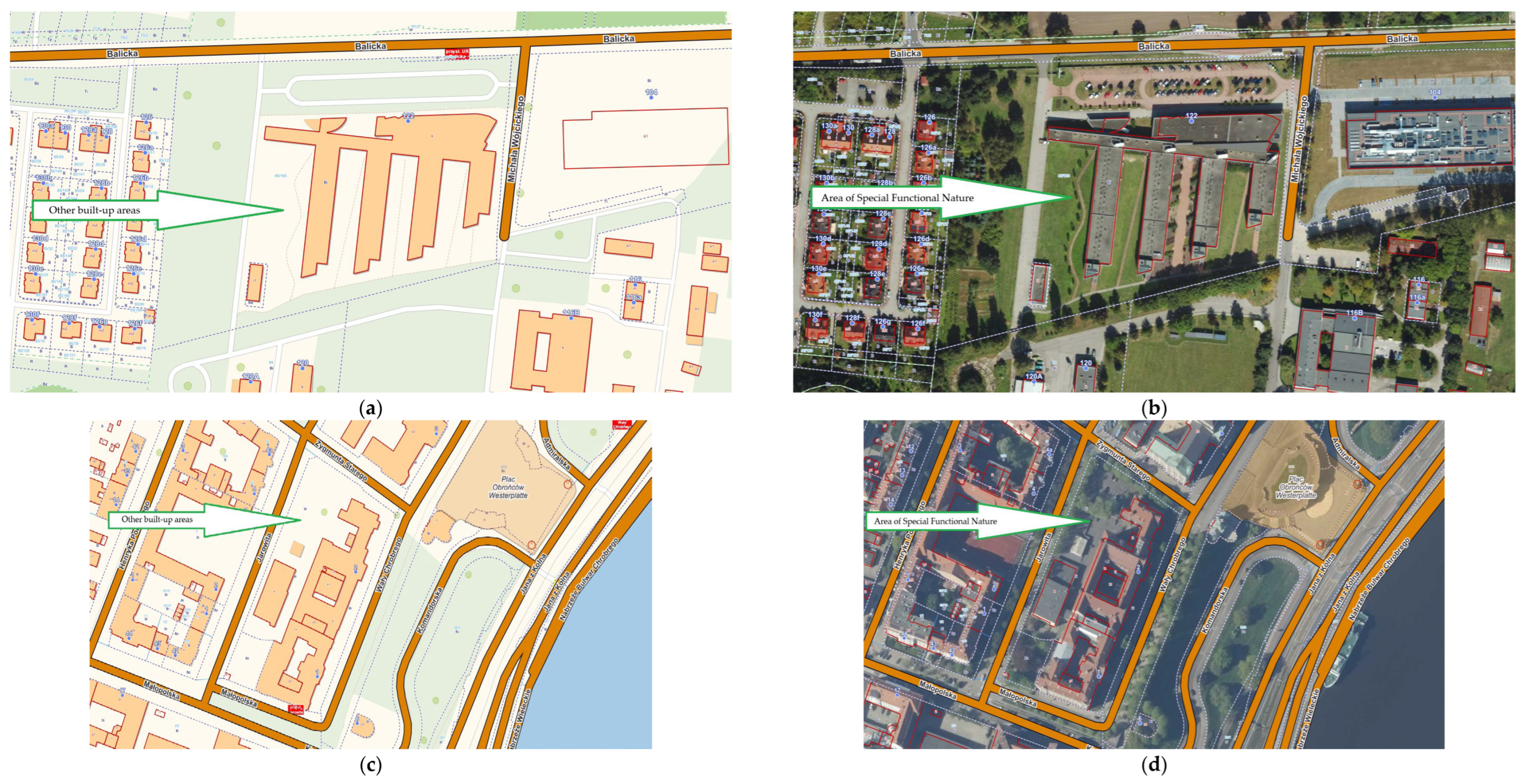
- An area of special functional nature, including “open” development in terms of how individual buildings are used in this area.
- Special usage area, where building development exceeds 50% of the plot.
- Public tasks and society.
- Administration.
- Education and scientific research.
- Culture.
- Religious institutions.
- Health, spa.
- Community, referring to an area mainly containing social buildings such as kindergartens, youth and senior centers, shelters, and facilities for the homeless.
- Security and order.
- Areas containing publishing houses, radio, film studios, television, and areas used for communication.
- Historical complex.
- International airport
- Regional airport
- Special airport
- Commercial airport
- Special landing site
- Helipad
- Gliding site
4. Results
4.1. Results of the Comparison of Land Use Registration in Poland with Land Use in Austria and the Brandenburg Region of Germany
- occupied by residential buildings;
- occupied by utility and technical buildings functionally related to the residential buildings referred to in point 1, as well as installations, in particular courtyards, driveways, walkways, home playgrounds and recreational areas, wells, tanks, overhead lines, sewage collection and treatment devices, waste bins, waste disposal sites, small architectural objects, fences, ponds, and rock gardens;
- located between or directly adjacent to the buildings and installations referred to in points 1 and 2 and not used for another purpose that would justify their classification under a different land use group, including areas occupied by lawns, flower beds, flower gardens, and vegetable gardens [35].
- Area of special functional nature—open space
- Area of special functional use—densely built-up space, the development creates continuous fronts
4.2. Proposal for Changes
- (a)
- Administration, i.e., areas where mainly public administration buildings are located, such as town halls, courts, or district offices;
- (b)
- Education and scientific research, i.e., areas where mainly buildings such as schools, universities, and research institutes are located;
- (c)
- Culture, i.e., areas where buildings and facilities are primarily used for cultural purposes, such as concert halls, museums, libraries, theaters, cinemas, and radio and television headquarters;
- (d)
- Religious institutions;
- (e)
- Healthcare, i.e., areas where mainly healthcare buildings are located, such as hospitals, clinics, treatment centers, sanatoriums, health resorts, and nursing homes;
- (f)
- Social services, i.e., areas where mainly social buildings are located, such as social welfare homes, hospices, kindergartens, youth and senior facilities, centers for foreigners, and homeless shelters;
- (g)
- Public safety and order, i.e., areas where mainly police, fire departments, border guards, customs, and tax services are located, as well as military areas and correctional institutions.
5. Discussion
6. Conclusions
Author Contributions
Funding
Institutional Review Board Statement
Informed Consent Statement
Data Availability Statement
Conflicts of Interest
Abbreviations
| MDPI | Multidisciplinary Digital Publishing Institute |
| DOAJ | Directory of open access journals |
| TLA | Three-letter acronym |
| LD | Linear dichroism |
Appendix A

| No. | Germany | Poland |
|---|---|---|
| 1 | Residential area | Residential areas |
| 2 | Single-family housing | |
| 3 | Multi-family housing | |
| 4 | Residential area associated with housing zones | |
| 5 | Industrial-commercial areas | Industrial areas |
| 6 | Industry and commerce | |
| 7 | Storage space | |
| 8 | Shipyard | |
| 9 | Trade and services | Other built-up areas |
| 10 | Trade | |
| 11 | Exhibition, fairs | |
| 12 | Horticulture | |
| 13 | Public utility supplying electricity, heat, and water | Industrial areas |
| 14 | Water supply system | |
| 15 | Nuclear power plant | |
| 16 | Power system using solar energy | |
| 17 | Power system using wind | |
| 18 | Power system—combustion | |
| 19 | Supply facility—coal | |
| 20 | Facilities for extraction of raw materials and energy sources | Extractive land uses |
| 21 | Extraction—crude oil | |
| 22 | Extraction—natural gas | |
| 23 | Water supply | Industrial areas |
| 24 | Power plant | |
| 25 | Hydroelectric power plant | |
| 26 | Nuclear power plant | |
| 27 | Power plant using solar energy | |
| 28 | Wind power plant | |
| 29 | Power plant using combustion | |
| 30 | Coal-fired power plant | |
| 31 | Substation | |
| 32 | Refinery | |
| 33 | Heating plant | |
| 34 | Thermal power plant—nuclear power plant | |
| 35 | Heating installation using solar energy | |
| 36 | Heating installation using combustion | |
| 37 | Coal-fired heating plant | |
| 38 | Waste disposal | |
| 39 | Wastewater treatment plant | |
| 40 | Waste processing facility | |
| 41 | Landfill (above ground) | Industrial area. No specification whether the landfill is above or below ground. |
| 42 | Landfill (underground) | |
| 43 | Industrial and commercial parking areas | Other built-up areas |
| 44 | Spoil heap | Industrial areas |
| 45 | Underground mine | Industrial areas, but since the area concerns post-extraction sites, it may also be classified as extractive land use. |
| 46 | Mining operation—decommissioned | |
| 47 | Open-pit mine, pit, quarry | |
| 48 | Open-pit mine, pit, quarry—clay | |
| 49 | Open-pit mine, pit, quarry—clay—decommissioned, abandoned | |
| 50 | Open-pit mining, mine, quarry—clay | |
| 51 | Open-pit mining, mine, quarry—clay Inactive, closed, abandoned | |
| 52 | Open-pit mine, pit, quarry—sand | |
| 53 | Open-pit mine, pit, quarry—sand—decommissioned, abandoned | |
| 54 | Open-pit mine, pit, quarry—gravel, gravelly sand | |
| 55 | Open-pit mine, pit, quarry—gravel, gravel sand—decommissioned, abandoned | |
| 56 | Open-pit mine, pit, quarry—quartz sand | |
| 57 | Open-pit mine, pit, quarry—quartz sand—decommissioned, abandoned | |
| 58 | Open-pit mine, pit, quarry—limestone | |
| 59 | Open-pit mine, pit, quarry—limestone—decommissioned, abandoned | |
| 60 | Open-pit mine, excavation, quarry—greywacke | |
| 61 | Open-pit mine, excavation, quarry—greywacke—decommissioned, abandoned | |
| 62 | Open-pit mine, excavation, quarry—peat | |
| 63 | Open-pit mine, excavation, quarry—peat Inactive, decommissioned, abandoned | |
| 64 | Open-pit mine, excavation, quarry—lignite | |
| 65 | Open-pit mining, mine, quarry—lignite—inactive, closed, abandoned | |
| 66 | Open-pit mine, excavation, quarry—areas not included in the above classes | |
| 67 | Area with special functional characteristics | Industrial areas, other built-up areas, miscellaneous areas |
| 68 | Area with special functional characteristics—open space | |
| 69 | Area with special land use characteristics—densely built-up space | |
| 70 | Public and societal functions | Other built-up areas |
| 71 | Administration | |
| 72 | Education and research | |
| 73 | Culture | |
| 74 | Religious institution | |
| 75 | Safety and public order | |
| 76 | Health, spa | Other built-up areas or recreational areas |
| 77 | Community | Other built-up areas |
| 78 | Media and communication | |
| 79 | Historic complex | Residential areas or other built-up areas or industrial areas or recreational areas |
| 80 | Public and societal functions | Miscellaneous areas |
| 81 | Public and societal functions | Recreational areas |
| 82 | Sports facility | Other built-up areas or recreational areas |
| 83 | Golf course | Recreational areas |
| 84 | Recreational facility | |
| 85 | ZOO | |
| 86 | Safari park or wildlife park | |
| 87 | Amusement park | |
| 88 | Open-air theater | |
| 89 | Heritage park (skansen) | |
| 90 | Drive-in cinema, outdoor cinema | |
| 91 | Model aircraft flying area | Other transport areas, miscellaneous areas |
| 92 | Recreational area | Recreational areas |
| 93 | Weekend and holiday home area | |
| 94 | Swimming pools | |
| 95 | Campground | |
| 96 | Green area | |
| 97 | Park | |
| 98 | Allotment gardens | |
| 99 | Sports, leisure, and recreation area—areas not classified under the above categories | |
| 100 | A cemetery is defined as a plot of land that is or was used for burials, unless it would be more appropriate to classify it as a green area. | Other built-up areas or recreational areas |
| 101 | Cemetery—area not classified in the above category | Other built-up areas |
| 102 | Road traffic | Roads |
| 103 | Area associated with road traffic | |
| 104 | Path | Residential areas or roads |
| 105 | Square | Roads |
| 106 | Pedestrian zone | |
| 107 | Parking space | |
| 108 | Rest area | |
| 109 | Rest area or truck stop | |
| 110 | Festival grounds | |
| 111 | Railway transport | Railway areas |
| 112 | Area accompanying rail traffic | |
| 113 | Railway transport—areas not included in the above classes | |
| 114 | Air traffic | Other transport areas |
| 115 | International airport | |
| 116 | Regional airport | |
| 117 | Special airport | |
| 118 | Commercial airport | |
| 119 | Special landing site | |
| 120 | Helipad | |
| 121 | Gliding area | |
| 122 | Air traffic—areas not included in the above classes | |
| 123 | Shipping traffic | |
| 124 | Port facility (land area) | |
| 125 | Lock (land area) | |
| 126 | Shipping traffic—areas not included in the above classes |
Appendix B
| No. | Austria | Poland |
|---|---|---|
| 1 | Built-up Area | Residential Areas |
| 2 | Buildings | |
| 3 | Paved surfaces directly related to buildings | |
| 4 | Gardens | |
| 5 | Road infrastructure | Transport areas—roads |
| 6 | Railway infrastructure | Transport areas—railway land |
| 7 | Side surfaces | Areas are integrated into adjacent land uses |
| 8 | Parking areas | Other transport areas |
| 9 | Business areas (industrial and commercial land) | Areas designated for commerce are classified under other built-up areas. For this study, Austrian industrial land is considered equivalent to industrial areas. |
| 10 | Storage areas | Industrial areas |
| 11 | Waste disposal sites | |
| 12 | Company premises | Other built-up areas |
| 13 | Parking areas in shopping centers, recreational facilities, and other types of parking | Other transport areas |
| 14 | Port facilities | |
| 15 | Airport facilities | |
| 16 | Spoil heaps and landfill areas | Extractive land |
| 17 | Permanent storage areas for mining waste | Industrial areas, but since the area concerns post-mining land, it may also be classified as extractive land. |
| 18 | Recreational areas | Recreational or wooded/shrubby areas recorded as forest land use |
| 19 | Cemeteries | Other built-up areas |
| 20 | Rocky and gravel areas | Unused land |
References
- Kaim, D.; Kozak, J.; Kolecka, N.; Ziółkowska, E.; Ostafin, K.; Ostapowicz, K.; Gimmi, U.; Munteanu, C.; Radeloff, V.C. Broad scale forest cover reconstruction from historical topographic maps. Appl. Geogr. 2016, 67, 39–48. [Google Scholar] [CrossRef]
- Steffen, W.; Crutzen, P.J.; McNeill, J.R. The Anthropocene: Are humans now overwhelming the great forces of nature. Ambio-J. Hum. Environ. Res. Manag. 2007, 36, 614–621. [Google Scholar] [CrossRef]
- Kazak, J.K.; Błasik, M.; Świater, M. Land use change in suburban zone: European context of urban sprawl. J. Water Land Dev. 2022, 92–98. [Google Scholar] [CrossRef]
- Karabin-Zych, M. The Issue of Updating the Real Estate Cadastre in the Field of Land Use in Connection with the Construction of a Building. Geomat. Environ. Eng. 2021, 15, 33–58. [Google Scholar] [CrossRef]
- Matuk, O. A Comparison of Land Use Classifications in Urbanized Areas in Selected European Countries. Geomat. Environ. Eng. 2021, 15, 59–66. [Google Scholar] [CrossRef]
- Noszczyk, T. A review of approaches to land use changes modeling. Hum. Ecol. Risk Assess. 2019, 25, 1377–1405. [Google Scholar] [CrossRef]
- Ustawa z dnia 12 Stycznia 1991 r. o Podatkach i Opłatach Lokalnych [Act of 12 January 1991 on Local Taxes and Fees] (t.j.Dz. U. z 2023 r.poz. 70, 1313,2291, z 2024 r.poz. 1572, 1635,1757.). Available online: https://isap.sejm.gov.pl/isap.nsf/DocDetails.xsp?id=WDU19910090031 (accessed on 10 March 2025).
- Piotrowska-Marczak, K.; Głuchowski, J.; Fila, J. Konsekwencje Zmiany Obciążeń Podatkowych W Polsce [The Consequences of Changes in Tax Burdens in Poland]; Difin: Warsaw, Poland, 2013; ISBN 978-83-7930-369-4. [Google Scholar]
- Ustawa z dnia 13 Maja 1994 r. o Stosunku Państwa do Kościoła Ewangelicko-Reformowanego w Rzeczypospolitej Polskiej [Act of 13 May 1994 on the Relationship Between the State and the Evangelical Reformed Church in the Republic of Poland] (Dz.U.2015.483 t.j. z dnia 2015.04.03). Available online: https://isap.sejm.gov.pl/isap.nsf/DocDetails.xsp?id=WDU19940730324 (accessed on 10 March 2025).
- Ustawa z dnia 20 Lutego 1997 r. o Stosunku Państwa do Gmin Wyznaniowych Żydowskich w Rzeczypospolitej Polskiej [Act of 20 February 1997 on the Relationship Between the State and Jewish Religious Communities in the Republic of Poland] (Dz.U.2014.1798 t.j. z dnia 2014.12.15). Available online: https://isap.sejm.gov.pl/isap.nsf/DocDetails.xsp?id=WDU19970410251 (accessed on 10 March 2025).
- Ustawa z dnia 30 Maja 1996 r. o Gospodarowaniu Niektórymi Składnikami Mienia Skarbu Państwa i Agencji Mienia Wojskowego [the Act of 30 May 1996 on the Management of Certain Components of State Treasury Property and on the Military Property Agency] (Dz.U. Nr 90, poz. 405 z późno zm.). Available online: https://isap.sejm.gov.pl/isap.nsf/DocDetails.xsp?id=WDU19960900405 (accessed on 10 March 2025).
- Ustawa z dnia 13 Października 1998 r. o Systemie Ubezpieczeń Społecznych [Act of 13 October 1998 on the Social Insurance System] (Dz.U. Nr 1 37, poz. 8 87 z późno zm.). Available online: https://isap.sejm.gov.pl/isap.nsf/DocDetails.xsp?id=wdu19981370887 (accessed on 10 March 2025).
- Ustawa z dnia 20 Lipca 2017r. o Krajowym Zasobie Nieruchomości [Act of 20 July 2017 on the National Property Stock] (t.j.: Dz. U. z 2024 r. poz. 1026, 1089, z 2025 r. poz. 39.). Available online: https://isap.sejm.gov.pl/isap.nsf/DocDetails.xsp?id=wdu20170001529 (accessed on 10 March 2025).
- Etel, L. Opodatkowanie Nieruchomości Problemy Praktyczne [Property Taxation: Practical Issues]; Temida 2: Białystok, Poland, 2001. [Google Scholar]
- Bielecka, E.M.; Jenerowicz, A. Intellectual Structure of CORINE Land Cover Research Applications in Web of Science: A Europe-Wide Review. Remote Sens. 2019, 11, 2027. [Google Scholar] [CrossRef]
- Matuk, O. Zmiany rejestracji użytków gruntowych od założenia ewidencji grantów i budynków do chwili obecnej wraz ze zmieniającą się sytuacją polityczną. Przegląd Geod. [Geod. Rev.] 2023, 10, 38–41. [Google Scholar]
- Stańczuk-Gławniczek, M. Analysis of class-land use symbols inconsistencies with the conceptual cadastral data model specification. Infrastruct. Ecol. Rural. Areas 2018, 3, 829–842. [Google Scholar] [CrossRef]
- Noszczyk, T.; Hernik, J. The necessity to keep land and property registers in an active manner. Infrastruct. Ecol. Rural. Area 2017, 1, 229–241. [Google Scholar] [CrossRef]
- LUCAS 2015 (Land Use/Cover Area Frame Survey)—Dokument Źródłowy: C3 Klasa (Użytk Lądowy i Pokrywa Gruntów); Eurostat Technical Report; European Commission: Brussels, Belgium, 2015.
- Stehman, S.V. Sampling designs for accuracy assessment of land cover. Int. J. Remote Sens. 2009, 30, 5243–5272. [Google Scholar] [CrossRef]
- Aune-Lundberg, L.; Strand, G.H. Comparison of variance estimation methods for use with two-dimensional systematic sampling of land use/land cover data. Environ. Model. Softw. 2014, 61, 87–97. [Google Scholar] [CrossRef]
- Geiß, C.; Pelizari, P.A.; Schrade, H.; Brenning, A.; Taubenböck, H. On the effect of spatially non-disjoint training and test samples on estimated model generalization capabilities in supervised classification with spatial features. IEEE Geosci. Remote Sens. Lett. 2017, 14, 2008–2012. [Google Scholar] [CrossRef]
- Weigand, M.; Staab, J.; Wurm, M.; Taubenböck, H. Spatial and semantic effects of LUCAS samples on fully automated land use/land cover classification in high-resolution Sentinel-2 data. Int. J. Appl. Earth Obs. Geoinf. 2020, 88, 102065. [Google Scholar] [CrossRef]
- Agenda 2030. Transforming Our World: The 2030 Agenda for Sustainable Development. Available online: https://sdgs.un.org/2030agenda (accessed on 24 February 2025).
- FAO. The State of the World’s Land and Water Resources for Food and Agriculture; FAO: Rome, Italy, 2011. [Google Scholar]
- Jansen, L.J.M.; Di Gregorio, A. Parametric land cover and land-use classifications as tools for environmental change detection. Agric. Ecosyst. Environ. 2002, 91, 89–100. [Google Scholar] [CrossRef]
- Diaz-Pacheco, J.; Gutierrez, J. Exploring the limitations of CORINE Land Cover for monitoring urban land-use dynamics in metropolitan areas. J. Land Use Sci. 2014, 9, 243–259. [Google Scholar] [CrossRef]
- Ahlcrona, E.; Ledwith, M.; Olsson, B. Global Land Cover 2000: Classification Legend for “Scandinavian Window”; Institute for Environment and Sustainability: Ispra, Italy, 2000. [Google Scholar]
- Letourneau, A.; Verburg, P.H.; Stehfest, E. A land-use systems approach to represent land-use dynamics at continental and global scales. Environ. Model. Softw. 2012, 33, 61–79. [Google Scholar] [CrossRef]
- Mika, M. Modernisation of the Cadastre in Poland as a tool to improve the land management and administration process. Surv. Rev. 2020, 52, 224–234. [Google Scholar] [CrossRef]
- Grzelak, G. Ontologia—próba usystematyzowania pojęć informatyka ekonomiczna [Ontology—An attempt to systematize concepts in economic informatics]. In Business Informatics; Publishing House of the Wrocław University of Economics: Wrocław, Poland, 2013; Volume 4, ISSN 1507-3858. [Google Scholar]
- Hanus, P. Wykorzystanie dokumentacji byłego katastru austriackiego do regulacji stanu prawnego nieruchomości. Geomat. Environ. Eng. 2007, 1, 127–138. [Google Scholar]
- Mika, M. Historia katastru polskiego [History of the Polish Cadastre]. In Infrastructure and Ecology of Rural Areas, Nr 6/2010; Polish Academy of Sciences, Branch in Kraków: Kraków, Poland, 2010; pp. 75–85. [Google Scholar]
- Rozporządzenie Ministra Rozwoju i Technologii z dnia 19 Grudnia 2024 r. Zmieniające Rozporządzenie w Sprawie Ewidencji Gruntów i Budynków [Regulation of the Minister of Development and Technology of 19 December 2024 Amending the Regulation on the Land and Building Register] (Dz.U. 2024 poz. 1954). Available online: https://isap.sejm.gov.pl/isap.nsf/DocDetails.xsp?id=WDU20240001954 (accessed on 10 March 2025). (In Polish)
- Rozporzedzanie Ministra Rozwoju, Pracy i Technologii z dnia 27 Lipca 2021 r. w Sprawie Ewidencji Gruntów i Budynków, Zmienione [Regulation of the Minister of Development, Labour and Technology of 27 July 2021 on the Land and Building Register] (Dz.U. 2021 poz. 1390). Available online: https://isap.sejm.gov.pl/isap.nsf/DocDetails.xsp?id=WDU20210001390 (accessed on 10 March 2025). (In Polish)
- Rozporządzenie Ministra Rozwoju, Pracy i Technologii z dnia 23 Września 2021 r. Zmieniające Rozporządzenie w Sprawie Ewidencji Gruntów i Budynków [Regulation of the Minister of Development, Labour and Technology of 23 September 2021 Amending the Regulation on the Land and Building Register] (Dz.U. 2021 poz. 1781). Available online: https://isap.sejm.gov.pl/isap.nsf/DocDetails.xsp?id=WDU20210001781 (accessed on 10 March 2025). (In Polish)
- Rozporządzenie Ministra Rozwoju i Technologii z dnia 15 Marca 2023 r. Zmieniające Rozporządzenie w Sprawie Ewidencji Gruntów i Budynków [Regulation of the Minister of Development and Technology of 15 March 2023 Amending the Regulation on the Land and Building Register] (Dz.U. 2023 poz. 745). Available online: https://isap.sejm.gov.pl/isap.nsf/DocDetails.xsp?id=WDU20230000745 (accessed on 10 March 2025). (In Polish)
- Bundesgesetz Vom 3. Juli 1968 Über Die Landesvermessung und den Grenzkataster (Vermessungsgesetz) [Federal Law of July 3, 1968 on Land Surveying and the Boundary Cadastre—Surveying Law]. Available online: https://www.ris.bka.gv.at/GeltendeFassung.wxe?Abfrage=Bundesnormen&Gesetzesnummer=10011400 (accessed on 10 March 2025). (In Austrian).
- Verordnung des Bundesministers für Wirtschaft, Familie und Jugend über die Angabe und Definition der Benützungsarten und Nutzungen im Grenzkataster, BGBl. II Nr. 116/2010 [Ordinance of the Federal Minister for Economic Affairs, Family and Youth on the Indication and Definition of the Types of Use and Uses in the Border Cadastre, BGBl. II No. 116/2010]. Available online: https://www.ris.bka.gv.at/GeltendeFassung.wxe?Abfrage=Bundesnormen&Gesetzesnummer=20006750 (accessed on 10 March 2025). (In Austrian).
- Act of 27 May 2009 on the Geodesy of the Federal State of Brandenburg (Brandenburg Geodesy Act—BbgVermG) (Gwoli/09, Nr 08, s.166). Available online: https://bravors.brandenburg.de/gesetze/bbgvermg (accessed on 10 March 2025). (In German).
- Gesetz und Verordnungsblatt für das Land Brandenburg Teil I—Gesetze, Gesetz zur Änderung des Brandenburgischen Vermessungsgesetzes Vom 19. June 2019 (GVBl. I—2019, nr (32). Available online: https://bravors.brandenburg.de/sixcms/media.php/76/GVBl_I_32_2019.pdf (accessed on 10 March 2025). (In German).
- Nachweis der Nutzungsarten und Klassifizierungen im Liegenschaftskataster (Nutzungsartenerlass) vom 1. Juli 2024. Available online: https://mik.brandenburg.de/sixcms/media.php/9/2024-09-16_Erlass_Nutzungsarten_2024-07-01.pdf (accessed on 10 March 2025). (In German).


| No. | Land Use Class | Basic Classifiers for Land Use Classification |
|---|---|---|
| 1 | Residential Areas | Land not classified as agricultural Land occupied by residential buildings Land occupied by buildings functionally related to residential buildings Land between buildings functionally related to residential buildings |
| 2 | Industrial Areas | Land built up with industrial buildings Land built up with warehouse buildings Land built up with buildings functionally related to industrial buildings Land built up with buildings functionally related to warehouses Land between buildings functionally related to industrial or warehouse buildings Land occupied by transport and repair bases Transformer stations Above-ground pipelines, collectors, and water supply systems Heaps Landfills Water intakes |
| 3 | Other Built-up Areas | Land occupied by buildings other than residential Land occupied by buildings other than industrial Land occupied by buildings other than warehouses Structures or facilities related to buildings other than residential, industrial, or warehouse buildings Land located between buildings, structures, and facilities Land occupied by active cemeteries Land occupied by inactive cemeteries Animal burial sites |
| 4 | Urbanized Unbuilt or Under-construction Areas | Land where construction has started but not been completed Land excluded from agricultural or forestry production When determining the contours of urbanized unbuilt or under-construction areas, the provisions of the decision excluding the land from agricultural or forestry production are considered |
| 5 | Recreational and Leisure Areas | Land of holiday resorts Children’s playgrounds Beaches Landscaped parks Squares Green areas outside street lanes Historic areas such as castle ruins, strongholds, burial mounds, natural monuments Sports areas such as stadiums, sports fields, ski jumps, toboggan runs, shooting ranges, swimming areas, golf courses Entertainment areas such as amusement parks, funfairs Zoos Botanical gardens Uncultivated green areas not classified as forests or afforested and shrubby lands Family allotment gardens |
| 6 | Mining Areas | Land occupied by active open-pit mines where mineral extraction occurs Excavations after mineral extraction Sinkholes and land affected by mining activity |
| 7 | Roads | Land under the road corridors of public and internal roads |
| 8 | Railway Areas | Land occupied by structures and other facilities intended for the operation and service of railway traffic, transport of people or goods, or maintenance: railway lines, sidings with infrastructure as part of them, stations, ramps, warehouses, etc. |
| 9 | Other Transport Areas | Airports Structures and facilities serving air transport Harbor facilities, harbors, structures, and facilities serving water transport Structures and facilities for cable railways Tramway tracks outside street and road lanes, as well as objects and facilities related to urban transport Organized parking lots outside state forests, bus stations Water protection embankments adapted for vehicular traffic |
| 10 | Land Designated for Public Roads or Railways | Land owned by the State Treasury or local government units, allocated for public roads or railway lines based on administrative decisions |
| Austria | Poland |
|---|---|
| Built-up area Buildings Paved surfaces directly associated with buildings Gardens | Residential areas |
| Road traffic infrastructure | Transport areas—roads |
| Railway transport infrastructure | Transport areas—railway land |
| Side areas | Areas are included as part of adjacent land uses |
| Parking spaces | Other transport areas |
| Activity areas (industrial and commercial land) | There is no separate classifier for land designated for commercial use. Instead, the classifier “industrial land” is used. Land designated for commercial purposes is registered under other built-up areas. However, for the purposes of this study, it was assumed that industrial areas registered in Austria are equivalent to industrial areas. |
| Storage areas Waste disposal sites | Industrial areas |
| Company premises | These are not distinguished as a separate classifier. Land used in this way is included under other built-up areas. |
| Parking lots at shopping centers, recreational facilities, and other types of parking areas Port facilities Airport facilities | Other transport areas |
| Heap and landfill surfaces | Extractive land use |
| Areas for permanent storage of mining waste | There is no specific classifier for this category. Land used as spoil heaps is classified as industrial land, but since it concerns post-mining areas, it may also be included under extractive land use. |
| Recreational areas | Recreational areas or wooded and bush-covered areas are registered under forest land use. |
| Cemeteries | Other built-up areas |
| Rocky and gravel area Buildings | Wasteland |
| Germany | Poland |
|---|---|
| Areas with a Special Functional Nature | |
| Areas with a special functional nature—open space Areas with a special functional use—densely built-up space, the development creates continuous fronts | Industrial areas, other built-up areas, miscellaneous areas |
| Public and community services—Other built-up areas Administration Education and research Culture Religious institutions Safety and public order | Public and community services—Other built-up areas |
| Health, spa services | Other built-up areas or recreational areas |
| Community Media and communication | Other built-up areas |
| Historical areas | Residential areas or other built-up areas or industrial areas or recreational areas |
| Area with a special functional nature—land not classified under the above categories | Miscellaneous areas |
Disclaimer/Publisher’s Note: The statements, opinions and data contained in all publications are solely those of the individual author(s) and contributor(s) and not of MDPI and/or the editor(s). MDPI and/or the editor(s) disclaim responsibility for any injury to people or property resulting from any ideas, methods, instructions or products referred to in the content. |
© 2025 by the authors. Licensee MDPI, Basel, Switzerland. This article is an open access article distributed under the terms and conditions of the Creative Commons Attribution (CC BY) license (https://creativecommons.org/licenses/by/4.0/).
Share and Cite
Matuk, O.; Calka, B. Consolidating the Polish Land Use Cadastral Register with the Austrian and German Systems: An Extension of the Polish Cadastre Model Towards Sustainable Land Management. Sustainability 2025, 17, 5783. https://doi.org/10.3390/su17135783
Matuk O, Calka B. Consolidating the Polish Land Use Cadastral Register with the Austrian and German Systems: An Extension of the Polish Cadastre Model Towards Sustainable Land Management. Sustainability. 2025; 17(13):5783. https://doi.org/10.3390/su17135783
Chicago/Turabian StyleMatuk, Olga, and Beata Calka. 2025. "Consolidating the Polish Land Use Cadastral Register with the Austrian and German Systems: An Extension of the Polish Cadastre Model Towards Sustainable Land Management" Sustainability 17, no. 13: 5783. https://doi.org/10.3390/su17135783
APA StyleMatuk, O., & Calka, B. (2025). Consolidating the Polish Land Use Cadastral Register with the Austrian and German Systems: An Extension of the Polish Cadastre Model Towards Sustainable Land Management. Sustainability, 17(13), 5783. https://doi.org/10.3390/su17135783