Article

Apennine Natural Pasture Areas: Soil, Plant, and Livestock Interactions and Ecosystem Characterization

1
Dipartimento Agricoltura, Ambiente e Alimenti, Università degli Studi del Molise, 86100 Campobasso, Italy
2
Scuola di Bioscienze e Medicina Veterinaria, Università degli Studi di Camerino, 62032 Camerino, Italy
3
Global Agronomy, LLC, Marana, AZ 85658, USA
*
Author to whom correspondence should be addressed.
Sustainability 2025, 17(12), 5238; https://doi.org/10.3390/su17125238
Submission received: 10 March 2025 / Revised: 28 May 2025 / Accepted: 31 May 2025 / Published: 6 June 2025
(This article belongs to the Section Sustainability, Biodiversity and Conservation)

Abstract

:
Grasslands and livestock are essential to support the diversity of soils, plants, and animals. This study analyzes changes that occurred from 2019 to 2022 in two protected pasture areas of the Italian Apennines, designated as UNESCO (area 1) and NATURA2000 (area 2). In each area, three sampling sites were identified and georeferenced, and the soil was studied. Forage quality and productivity were assessed from botanical and chemical perspectives using biomass samples. Adult bovine unit and grazing index were calculated. Soils, classified as Phaeozems in area 1 and Fluvisols in area 2, exhibit a weak structure with an increased risk of compaction and erosion. The height of forage species and vegetal diversity increased during the study, and variations in botanical and chemical composition were observed. Forage productivity averaged 2760 (±1380 SEM) kg DM/ha in area 1 and 3740 (±1160) kg DM/ha in area 2. Animal population declined by 11.4% in area 1 and by 1.14% in area 2, along with a decrease in the number of livestock farms. From a multidisciplinary perspective, improving management would enhance the ecosystem services of pasture areas, including promoting the role of soil as a carbon sink. The results present means of resilience to enhance cultural and naturalistic values of sites in inner Mediterranean ecosystems.

1. Introduction

Pasture areas, which account for one-third of the world’s lands used for agricultural practices and production, are generally located in hilly and mountain regions characterized by peculiar pedo-climatic conditions that can affect vegetative growth. As a result, forage is available for short periods of time, mainly during spring and summer seasons [1,2,3]. Grassland areas, which include pasture and permanent meadows, can meet human needs and well-being by providing ecosystem services, such as soil, plant and animal conservation, environmental and landscape preservation, climate regulation, and unique cultural and recreational heritage protection [4,5,6,7,8]. Intensive land-use changes occurred during the 20th century in Mediterranean pasture areas. Socio-economic transformations weakened the pasture ecosystems due to natural and anthropogenic soil degradation processes [9]. Consequently, marginal and low-income areas of South-Central Italy were frequently depopulated and abandoned [10], contributing to a gradual decrease in small-scale agricultural production and consequent land degradation and loss of biodiversity. In addition to ecosystem services being related to human well-being in decision-making processes [11,12], European grasslands are responsible for producing up to 15 tons of dry matter ha−1 of forage [13]. Moreover, proper pasture management can increase the soil’s ability to store carbon dioxide and beneficially influence carbon and nitrogen fluxes, thereby mitigating greenhouse gas emissions from the livestock sector. Grasslands represent one of the most important biomes, able to contain about 30% of the world’s soil carbon stocks; however, poor grassland management has the potential to convert pastures from carbon sinks into carbon sources [14,15,16].
The vulnerability of montane ecosystems to global warming and climate change is particularly high in terms of soil water erosion [17]. Global warming can also have a significant negative impact on global soil organic carbon (SOC) stocks, increasing SOC mineralization at high temperatures [18,19] and reducing available water capacity [20], ultimately resulting in the decline of plant diversity [21]. The loss of plant and animal diversity can further alter SOC pools, reducing carbon input and increasing CO2 outputs from montane ecosystems to the atmosphere [22]. Increased plant species diversity can enhance carbon biomass production and subsequently boost SOC storage, whereas a decline in plant species diversity is associated with SOC depletion [6,15,23]. With ongoing losses in plant and animal diversity, the relationships among soil carbon cycling, land use, and soil management become critical for the survival of biodiversity in mountain environments [24,25,26]. In addition, soil quality strongly influences the primary growth of plants and animals, enabling the maintenance of healthy mountain ecosystems [27]. However, soil functionality is increasingly compromised by the long-term impacts of degradative processes, both natural and human-induced. Remediating soil fragility depends upon shifting from traditional grazing management to science-based and scalable sustainable solutions in pasture areas. By integrating advanced technologies, regenerative practices, and ecosystem-focused strategies, it is possible to improve soil health, grazing practices, and plant diversity to achieve broader environmental and social outcomes [28]. This integrated approach has the potential to transform pasture management and create lasting positive impacts on ecosystem services and human communities [29].
Mediterranean grasslands in the Central Apennine region represent a valuable case study of soil, plant, and animal diversity that play a crucial role in meeting the demand for animal products [30]. Grazing animals are characterized by specific feeding behavior to meet their nutritional needs, which vary according to their physiological state [16]. Moreover, pasture ecosystems can be influenced by animal species, grazing activity, landscape peculiarities, and management practices [31], which may also contribute to the heterogeneity of forage nutritive value [2]. Therefore, it is desirable to adopt a reliable tool to assess sustainable grazing pressure [32] since an inadequate distribution of livestock densities over a defined period of time can lead to either over-grazing or under-grazing. Consequently, maintaining grassland integrity together with soil functions will be increasingly important from different points of view, especially in vulnerable areas relevant for cultural and environmental reasons.
Research into soil functioning is essential to plan strategies to mitigate climate change effects on pasture areas due to the fact that climate changes in the Mediterranean mountains can alter grassland growth and biodiversity [33]. Human management practices, such as animal husbandry, directly influence soil quality and forage yields. The vulnerability of agricultural grasslands and the negative impacts of livestock management on ecosystem services and biodiversity emphasize the urgent need for solutions based on sustainable soil management systems to safeguard pastures in Mediterranean areas.
The aim of this study was to investigate soil characteristics, botanical composition, and related plant productivity, as well as the grazing livestock in two relevant pasture areas representative of inner Mediterranean regions over a four-year period, from 2019 to 2022. The study specifically focuses on one of the most important ecosystems in the region: natural pastures, which have historically served as a primary source of forage for livestock. Based on the existing literature and official records since 1992 [34], the present study provides a comprehensive view of ecosystem evolution in relevant areas with an interdisciplinary approach.

2. Materials and Methods

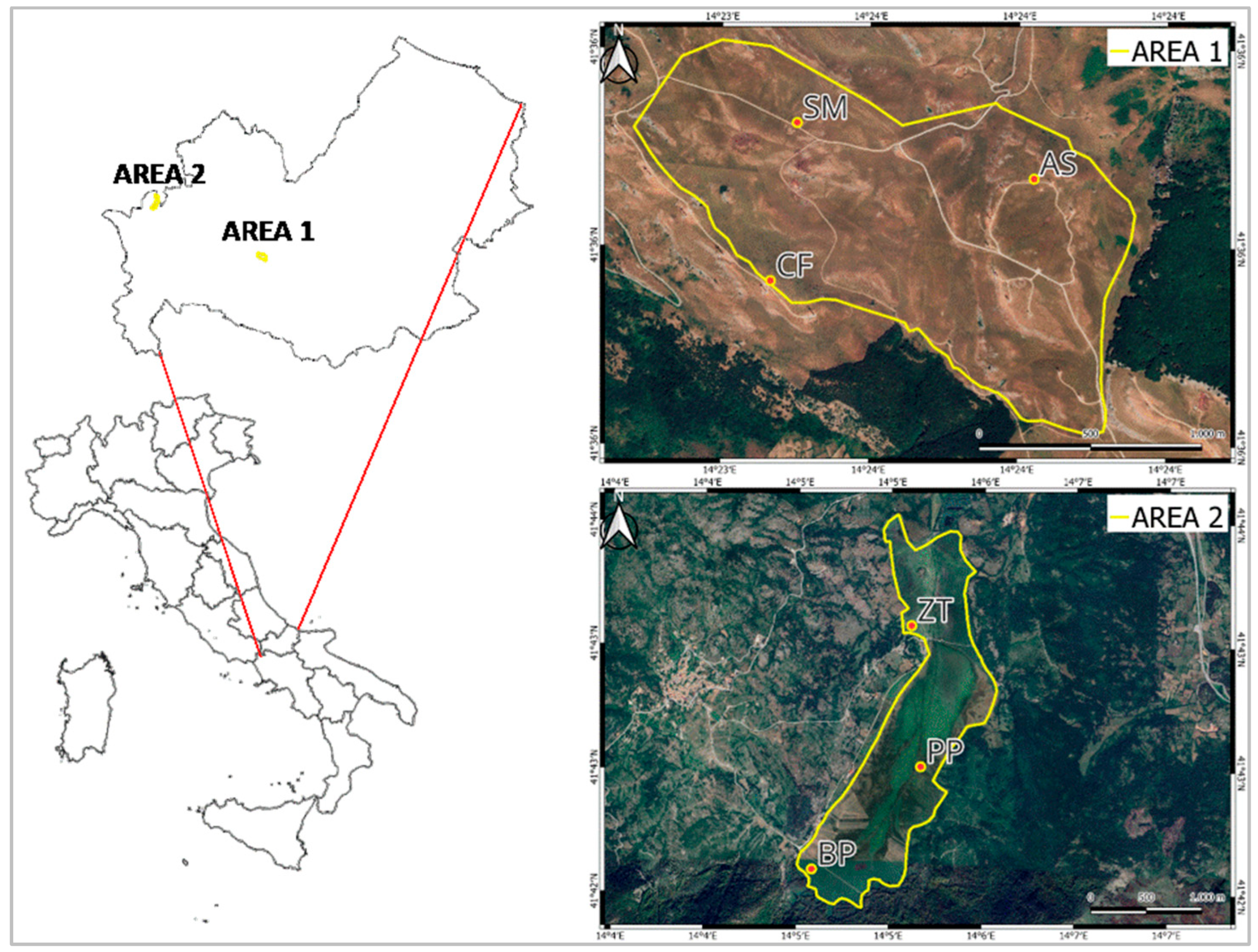
2.1. Study Area Description

The study was conducted in two grassland areas of Apennine (Isernia province, Italy): area 1, located in Frosolone municipality (41°36′ N 14°27′ E), and area 2, located in Montenero Val Cocchiara municipality (41°43′ N 14°04′ E) (Figure 1).
The two areas were chosen according to the existing literature [34] regarding the same areas, representative of the original landscape of South-Central Italy with different pedo-climatic conditions and grazing management.
The first area is a montane Apennine area at 1200 m above sea level, while the second area is a peatland situated at 850 m above sea level. These inner areas, historically used for seasonal migrations of sheep and cattle between mountain and lowland pastures in the neighboring Abruzzo and Molise regions, hold relevance from environmental and cultural points of view. More in detail, area 1 is located along the ancient transhumance roads (Tratturi), recognized as an Intangible Cultural Heritage [35]. Pasture wetland in area 2 is a Sites of Community Importance (SIC) under a protection program aimed to preserve habitats and local breeds, i.e., autochthonous Pentro horse, as well as plant communities, i.e., Salix pentandra and Dactylorhiza incarnata [36,37].
Figure 1. Geographical localization of the study areas (yellow line) and spatial representation of sampling areas 1 and 2 [38].
Sustainability 17 05238 g001
According to Molise Regional Law No. 6 of 18 January 2000, municipal authorities regulate the use of pasture areas reserved for farmers residing in the municipalities, following a declaration of species and number of grazing animals, as well as certification of the animals’ good health.
In area 1, cattle, equines, sheep, and goats graze for five months per year, from May to October, on natural pasture covering approximately 1000 hectares of agricultural area.
Area 2 is the southernmost peat bog in Europe, consisting of an intermontane basin originating from an ancient lake, covering about 200 hectares and crossed by the Zittola River [36]. The Montenero Val Cocchiara area, grazed by cattle and equines, includes around 900 hectares of agricultural area. The utilization of about 700 (out of 900) hectares of pasture area 2 is allowed from July to next March. Before the beginning of the grazing season, forage is allowed to be mechanically harvested by local farmers following the public allocation of parcels.

2.2. Sampling Design

Sampling sites (approximately 200 m2 each) were identified, respectively, in area 1 (Frosolone), namely Acqua Spruzza (AS), Colle Campo di Fave (CF), and Piana di Santa Maria (SM), and in area 2 (Montenero Val Cocchiara), namely Bocca del Pantano (BP), Ponte di Pietra (PP), and Zittola (ZI) (Figure 1). The pasture area of the ZI site (about 200 hectares) is grazed throughout the entire year.
Focusing on the grazing seasons of the period 2019–2022, sample sites were georeferenced and described from topographic and climatic perspectives, retrieving the average monthly temperature (°C) and monthly rainfall (mm) from official archives [39,40]. A thermo-pluviometric diagram was made for each area, according to Bagnouls and Gaussen [41]. The Aridity Index (AI), based on mean annual precipitation (MAP) and mean annual temperature (MAT) for a given region [42], was calculated for each study area for the period 1987–2022, as follows:
A I = M A P ( 10 + M A T )
Based on AI, ecosystems are classified into four types: semi-arid (10 < AI < 20), semi-humid (20 < AI < 30), humid (30 < AI < 60), and very humid (AI > 60) [42]. Moreover, dry years are characterized by drought intensities greater than 35% (for instance, a reduction in annual rainfall of more than 35% compared to the long-term average rainfall per year in each area), whereas common years exhibit drought intensities of less than 35% [43].
Within the studied sites, representative areas (0.5 m2, n = 99) were sampled in triplicate during the grazing periods. In each area sampled, the average forage height was recorded, and plant samples were cut at about 3–5 cm from the ground, simulating the animals’ feeding behavior. To assess forage quality in both pasture areas, biomass samples (n = 54 in area 1; n = 45 in area 2) were collected. Biomass sampling in ZI (area 2) was only possible in 2019, but site inspection was conducted during the grazing periods. Samples were analyzed for dry matter (DM), crude protein (CP), ash, neutral detergent fiber (NDF), and acid detergent fiber (ADF) contents, according to official methods [44]. A dichotomous key was used to identify plant species [45], while vegetal coverage was assessed according to Cislaghi et al. [46].
The soil sampling was performed in the studied sites according to the existing literature [34], considering the combination of a set of geographical factors, including the geological component, geomorphological elements (altitude and slope), and microclimate. Consequently, these landscape units represent homogeneous territorial areas with distinct characteristics, facilitating the examination and characterization of spatial and temporal variability. In the present study three soil profiles were investigated, respectively in area 1 and area 2. The six profiles were sampled, described, and classified using standard soil survey methodologies according to the International Union of Soil Sciences (IUSS) Working Group WRB classification [47]. Soil organic carbon was determined by wet digestion using the Walkley–Black procedure and total carbonates were determined by a gas-volumetric procedure (n = 15 for each area) [48,49]. The bulk density was determined using undisturbed samples (n = 15 for each area), according to Colombo and Miano [49].
For both the investigated period and previous years (2012–2018), variations in the number of livestock were analyzed by monitoring the number of grazing populations based on data provided by municipal archives. According to the official records, the grazing population was considered an adult bovine unit (ABU), i.e., the equivalent of one adult bovine, one adult equine, or six ovine and caprine heads. The grazing index (GI) was then calculated as the load of animals in pasture areas (ABU per hectare). Additionally, variations in the number of farms from 1982 to 2021 were recorded from the literature and official archives [34,50].

2.3. Statistical Analysis

Data on forage productivity, plant community, chemical components of pasture, and soil organic carbon were analyzed using one-way ANOVA; the Duncan test was used to compare mean values, and differences were considered significant at p < 0.05. All statistical analyses were conducted with IBM SPSS Statistics (Ver. 25.0. IBM Corp, Armonk, NY, USA). Data are presented as the mean and standard error of the mean (SEM).

3. Results

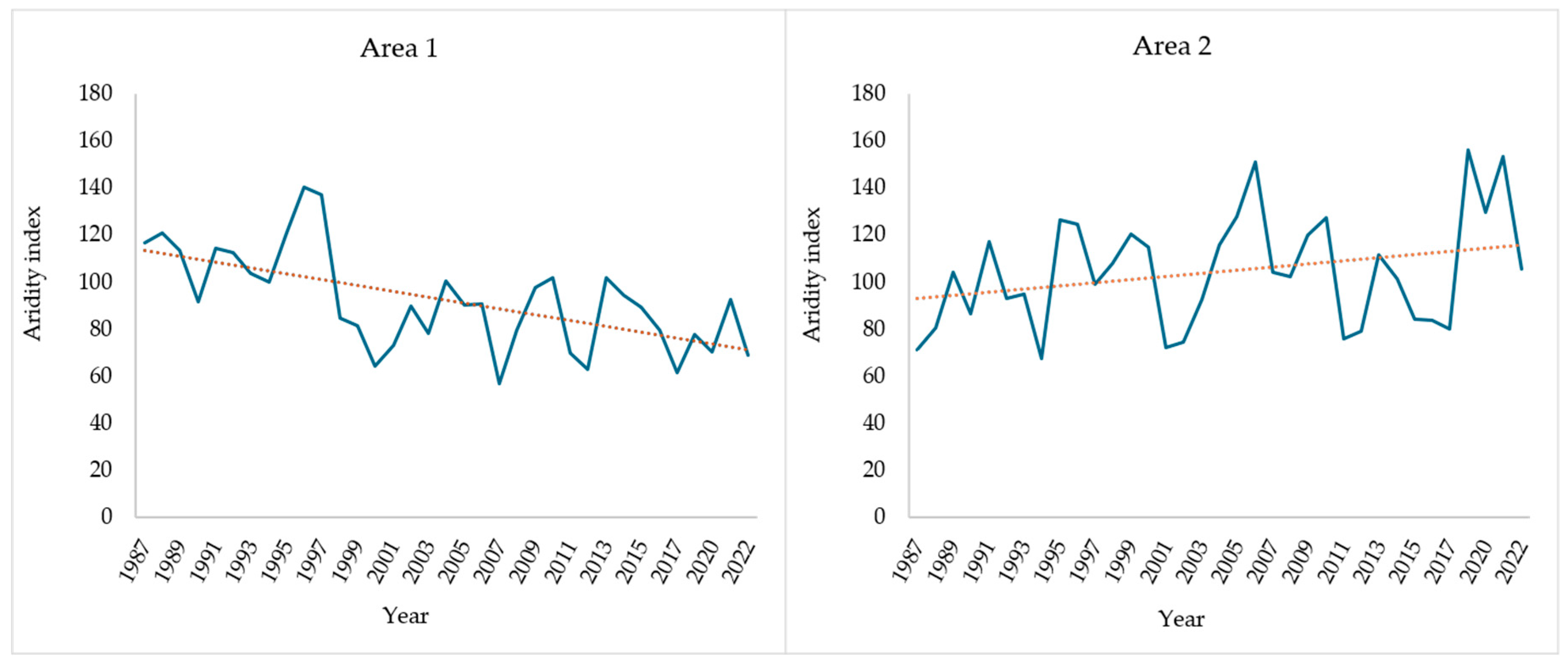
3.1. Topographical and Climatic Characterization of Study Areas

In area 1, sites AS and CF were characterized, respectively, by 10% slope and south and north-east exposure, while the SM site was in a flat area. Sites in area 2 (BP, PP, and ZI) were in a flat peatland. The climatic characterization of the investigated areas is described by thermo-pluviometric diagrams, as depicted in Figure 2. During the study period, the average annual precipitation in area 1 was 875.7 mm, and the monthly average rainfall varied from a minimum of 26.7 mm in June to a maximum of 178.4 mm in November. The average monthly temperature varied from a minimum of 3.8 °C in January to a maximum of 22.8 °C in July and August. Data from the grazing periods in area 1 indicate an increase in temperature and a decrease in rainfall in 2021, while in 2022, both temperature and rainfall increased.
In area 2, November was the rainiest month (241.4 mm), June was the driest (52.9 mm), and the average annual precipitation was 1331.5 mm. Based on the average monthly temperature, January was the coldest month (1.2 °C), while July was the hottest (20.8 °C). The 2019 grazing period was the warmest and the wettest.
The AI shows a declining trend for area 1, whereas it exhibits an upward pattern for area 2 over the analyzed period (Figure 3). However, the observed values of area 2 display greater dispersion around the trend line. Notably, both study areas exhibited anomalous years characterized by a reduction in rainfall. In area 1 this decline reached 39% in 2007, while in area 2 it peaked at 41% in 1994.

3.2. Plant Community Composition and Forage Characterization

During the period 2019–2022, the vegetal land cover in area 1 averaged 96.2 (±1.52 SEM)%, increasing from 90.0 (±2.89)% in 2019 to full coverage (100%) in 2022. The height of forage and the number of vegetal species in area 1 increased by 85.6% and 21.9%, respectively. No differences (p > 0.05) were observed among years within each family (Table 1). On average, Gramineae (grasses) were the most abundant plants in area 1 (about 60%), while Labiatae were the least represented. Grasses always remained predominant, followed by a prevalence of legumes, especially in the CF site, and by Compositae, especially in the AS site. Other herbaceous species observed in all selected sites were Achillea millefolium, Cardus spp., Festuca spp., Galium spp., Trifolium spp., while the most abundant shrub species were Crataegus monogyna and Rosa canina. Invasive species, such as Cynodon dactylon and Rumex crispus, were mainly detected along animal roads and in resting areas, particularly near the water points. The average annual productivity of area 1, 2760 (±1380) kg DM/ha, ranged from 1900 to 5000 kg DM/ha.
As Figure 4 shows, the biomass DM content in area 1 varied over the investigated period (p < 0.05), showing a minimum value of 28.5 g/100 g recorded in 2020, up to a maximum value of 40.3 g/100 g recorded in 2019; crude protein varied from a minimum value of 7.6 g/100 g DM in 2019 to a maximum value of 11.6 g/100 g DM in 2020 (p < 0.05); ash content increased from 6.73 g/100 g DM in 2019 to 8.32 g/100 g DM in 2022 (p < 0.001); and NDF content showed a sharp increase in 2021 (62.0 g/100 g DM, p < 0.05). The ADF content varied (p < 0.05) during the same study period (Figure 4).
As reported in Table 2, forage height and number of vegetal species did not vary in area 2 (p > 0.05) during the 2019–2022 period. About the vegetal land cover, a rise of 5.34% was observed, with a minimum value of 93.3% recorded in 2019 and a maximum value of 100% in 2022. However, it is worth noting that during 2019, samplings were conducted when grazing animals had early access to the BP, PP, and ZI sampling areas, meaning that a portion of the pasture had already been grazed. Considering the average forage composition, Gramineae plants fluctuated (p > 0.05) during the investigated period (Table 2) as they recovered especially in BP e PP sites. The Leguminosae family showed a considerable increase (50%, p < 0.05) in 2020 compared to the average for the entire period (about 25%); the Labiatae family increased tendentially (p < 0.1) in 2021, and Compositae remained stable (Table 2). More in detail, the dominant herbaceous species were Convolvulus arvensis, Lolium perenne, Phleum pratense, and Trifolium spp, especially in BP and PP sampling sites. Conversely, by a visual appraisal, the ZI site was characterized by the progressive expansion of Cardus spp, Ranunculus spp, and Juncus spp. The average forage productivity from 2019 to 2022 was 3740 (±1160) kg DM/ha, ranging from a minimum of 550 kg DM/ha in 2019 to a maximum of 5800 kg DM/ha in 2022.
DM content in area 2 varied significantly (p < 0.001) from 38.8 g/100 g in 2019 to 22.1 g/100 g in 2021. Average crude protein content ranged from 12.5 g/100 g DM (2019) to 7.5 g/100 g DM (2022) (p < 0.05), and ash content and fiber fractions remained stable during the investigated period (p > 0.05) (Figure 4).

3.3. Soil Characterization of Study Areas

The landscape unit of Frosolone mountain (area 1) is characterized by a plateau (maximum altitude: 1421 m above mean sea level), where the bedrock occasionally emerges together with several karstic depressions (dolina). The pasture area (1000 ha), developed on limestone outcrops, is surrounded by shrubs and a dense beech forest. Despite limestone being the geological substrate, soil profiles sampled in area 1 are totally decarbonated, generally acidic, and contain a substantial amount of siliceous skeleton in the deeper horizons. In the summit areas, the soil profile is less developed, with A-C horizon types (AS, Table 3). In two sampled profiles (SM and CF), a thin black layer at 52–77 cm depth, containing macroscopic charcoal remains (ranging in size from millimeters to two centimeters), was observed and identified as “fire relicts” (Table 3). The landscape of area 1, which is rich in surface Paleolithic stone artifacts [51], was identified as a Bronze Age settlement close to an ancient lake. These soils are classified as Andic (SM, CF) and Leptic (AS) Phaeozems, characterized by their dark, deep, and fertile profile. They are also rich in organic matter, particularly in the upper horizon, which gives them their dark coloration. The mean bulk density is 0.73 g d.w. cm−3 (±0.02). As shown in Table 3, these soil profiles exhibit a significant accumulation of SOC, ranging from 6% to 8% in the upper 20 cm layer.
The soils sampled in Montenero Val Cocchiara (area 2) were developed in a catchment area of about 2065 ha. The landscape units are characterized by an alluvial floodplain surrounded by mountains, and the elevation ranges from 820 m to 1258 m above sea level (Monte Curvale), representative of the variability in topographic, vegetative, and moisture conditions in the Zittola river catchment. According to the IUSS WRB classification [47], these soils are categorized as Histic Fluvisols. Their profiles extend to a depth of 60–70 cm, encompassing a peat layer rich in organic matter and roots, as detailed in Table 4. In the northern region of the catchment area, soil formation was influenced by Holocene alluvial calcareous sediments dated to over 2000 years ago. These soils exhibit moderate to high levels of calcium carbonate and a substantial SOC content (>7%) in both the surface layers and the buried horizons (Table 4). More in detail, the soils in area 2 are classified as Histic (PP) and Gleyic (ZI, BP) Fluvisols. These characteristics suggest that the soils formed under alluvial or fluvial conditions are usually found in areas where river or stream sediments accumulate. These result in soils that are rich in SOC mixed with silt and sand. These soils are developed under anaerobic conditions, where alluvial or fluvial processes contribute to the deposition of organic-rich materials, causing the formation of a distinct histic horizon (O or H) with a distinct layer of peat accumulation (Hb horizon, Table 4). The structure of a superficial horizon in Fluvisols varies from small lumpy to crumbly, indicating a marked phenomenon of surface compaction (Table 4). Compared to area 1, the mean bulk density values increased to 0.86 g d.w. cm−3 (±0.02). This condition could be a consequence of pasture management practices, which allow animals to graze mainly when the water table is near the surface.
Figure 5 shows the mean values of SOC in the two study areas. In Area 1 the high SOC content remains relatively stable (p > 0.05) across sampling sites, as also observed in area 2 according to their drainage conditions.

3.4. Grazing Animal and Farm Variations

The animal load of the studied areas, expressed as ABU, varied from 2019 to 2022, as shown in Table 5. In area 1, the average number of grazing animals decreased (−11.4%), and a lesser 1.14% decrease in livestock was observed in area 2 (Table 5). Accordingly, GI tended to decrease in both areas, with a 12.9% reduction in area 1 and a 1.14% reduction in area 2. Although the number of livestock farms was constant during the study period, it decreased during the past four decades [34]. In area 1, the number of farms decreased from 518 to 101 (80.5%), while in area 2, farms decreased from 100 to 23 units (77%).

4. Discussion

The variations observed in pasture areas over time may be attributable to a variety of factors, including climate, soil characteristics, plant and animal habitats, and anthropogenic activities. The Apennine chain, acting as a natural topographic barrier between warm western air masses and cold–humid eastern air masses, plays an important role in regulating the Italian climate [52]. According to the Köppen-Geiger classification system, climate is categorized into five main groups based on seasonal precipitation and temperature variations. South-Central Italy is predominantly characterized by hot summer and Mediterranean and temperate oceanic climate [53,54]. As is typical in the Apennine region, both selected pasture areas are characterized by seasonal temperature contrasts, with hot summers and cold winters, during which snowfall occurs frequently. Based on historical data reported in the literature [34,55], the average annual precipitation varied in the study areas. In 1992, the average annual rainfall was about 1537 mm and 1005 mm, respectively, in areas 1 and 2. Over the thirty-five-year time frame explored, precipitation halved in area 1, whereas it increased in area 2, as also confirmed by the reported AI trend. More in detail, the AI trend is due to different geomorphological conditions because area 2 is within a closed basin fed by several springs, while area 1 is a watershed ridge characterized by erosive morpho-dynamics. Comparing the present data with data from the literature [34], the average monthly temperature increased in area 1, compared to the minimum and the maximum recorded in 1992, which were 0.8 °C in January and 18.4 °C in August, respectively. During the same period, a decrease in the average temperature was observed in area 2, with historical minimum and maximum values recorded in January (3.6 °C) and in July (21.1 °C).
Soil plays a fundamental role in supporting plant life, influencing the forage productivity, management, and conservation of pasture areas. Consequently, degradation of soil health can lead to biodiversity loss, underscoring the need for tools to monitor and mitigate such declines to promote sustainable pasture ecosystems [56]. Andic Phaeozems, commonly found in temperate regions with grassland vegetation, are highly valued for mountain agriculture due to their excellent fertility and moisture-retaining capacity, both of which support plant growth and resilience of pastures in these important ecosystems [47].
In Area 1, Andic Phaeozems are a specific subgroup characterized by the presence of volcanic materials such as ash, tephra, or pyroclastic deposits, which contribute to their unique physical and chemical properties [57,58]. Leptic Phaeozems, on the other hand, are identified by their shallow profiles with direct lithic contact, often resulting from erosive processes that remove volcanic ash or upper soil layers. While these soils are characterized by high organic matter accumulation, their limited depth and lithic contact can affect their water-holding capacity and agricultural potential [47]. In the superficial horizons, the absent or lamellar structure has been observed, likely due to strong disturbance caused by animal trampling. Indeed, numerous livestock paths created by animal movements were observed throughout both the pasture areas. However, these soils formed on volcanic ash, although they are very rich in organic matter, can be considered particularly fragile due to their vulnerability to erosion by water and to compaction. CF and AS soils seem to lose their structure in the topsoil, making them more susceptible to physical degradation, especially in areas with steep slopes [59]. This structural fragility makes them particularly susceptible to soil compaction [15,60], especially in animal resting areas and along livestock roads. Soil compaction can interfere with the mechanisms responsible for the stabilization of SOC, thus reducing carbon accumulation capacity likely due to the high carbon input from land use and the effective preservation of SOC against decomposition. However, in soils formed on volcanic materials, the mechanisms responsible for the stabilization of SOC are particularly enhanced, contributing to their long-term carbon storage capacity [61]. These mechanisms include: (i) formation of SOC within organo-mineral complexes involving minerals containing aluminum (Al); (ii) reduced microbial activity due to low soil pH, limited cation content, and/or phosphorus deficiency; and (iii) physical protection of SOC within stable microaggregates [62]. The presence of volcanic materials, such as pyroclastic deposits in the mountainous area [63] and alluvial peat deposits in wetlands, highlights their importance in terms of soil development and soil properties in the South-Central Apennines [55,64]. The macroscopic charcoal remains observed in area 1, particularly within buried horizons as “fire relicts”, can be linked to paleo-surfaces where forest vegetation was replaced by pasture through the practice of burning, a method widely documented across the Apennines, particularly during Bronze Age human settlements [65,66]. The combustion of the original vegetation led to changes in land use, facilitating the expansion of open areas and subsequent conversion to pasture. This phenomenon has also been observed in other Apennine areas, such as Monte Cusna and Monte Cimone, where anthropogenic pressure on natural processes is documented [67]. The carbon storage capacity observed in area 1, according to Matus et al. [68], is closely related to the high concentration of poorly crystalline constituents associated with soil organic matter, i.e., humic–Al complexes, which provide physical and chemical protection against decomposition. These features indicate the significant role of pasture areas as carbon sinks. In area 2, the frequently high water table is mainly responsible for carbon accumulation within the soil. Fluvisols often display a wide range of textures that vary in depth, depending on the deposition history of the surrounding water bodies. In fact, Histic Fluvisols are characterized by a notable organic matter accumulation, primarily in the form of peat or muck, within the soil profile. The actual hydrologic condition of the wetland, determined mainly by anaerobic conditions, results in a significant buildup of organic matter [69]. In certain instances, this results in the appearance of grayish hues or patches, known as mottles, caused by the reduction in iron compounds. These characteristics are typical of Gleyic Fluvisols, indicating their presence within the wetland. The gley characteristics of aquic soils develop under conditions of anoxia, prolonged water saturation, and the depletion of elemental oxygen, which triggers reduction reactions involving Fe, Mn, and S [70]. However, the release of carbon dioxide into the atmosphere, which contributes to climate warming, is also driven by the interaction among carbon distribution across the soil horizons, microbial activity, the availability of nitrogen in pastures, and grazing activities [71,72]. In this regard, it is worth noting that animal trampling can lead to soil compaction, reducing soil porosity and penetrability, which affects the hydrological processes occurring within the soil [72]. Given the characteristics of area 2 soils and the specific mechanisms involved in the accumulation of SOC, this area appears to be more vulnerable to carbon release into the atmosphere, especially considering climate change perspectives. In the Apennine landscapes, soil development has been significantly influenced by frequent heavy rainfall, storm events, steep terrain, and extensive human activities. These factors make the soils notably fragile and vulnerable to erosion by water [73]. Additionally, abandoned landscapes underlain by hard rock formations, such as limestones, have been recognized as areas with a substantial risk of erosion [74]. Furthermore, the intensive agricultural practices adopted in the Apennine regions since the Neolithic period have likely influenced key soil functions and ecosystem services, including soil fertility, productivity, and carbon sequestration.
The dominant herbaceous species detected in all the selected sites align with previous findings reported in the literature for the same study areas [34,75,76]. The pasture productivity recorded in area 1 ranged between 2200 kg DM/ha [34] and 2900 kg DM/ha [75]. Pasture productivity observed in area 2 increased from values (900 kg DM/ha) reported by Di Rocco et al. [34], consistently with other Apennine areas [46] but accounting for only 10% of the productivity of Atlantic pastures [13]. The relatively low pasture yield of area 2 in 2019 is closely related to the lower forage cover observed. Regarding pasture quality, as indicated by chemical composition, grazed area 1 exhibited higher levels of both DM and NDF contents when compared to the literature data [75], with the highest values recorded in 2021, likely due to high temperature and low rainfall. In contrast, area 2 was characterized by lower DM and NDF contents, which may be related to peculiarities of the land where area 2 is located. Over the past thirty years, an increase in invasive species has been observed in both area 1 and area 2. The presence of Cardus spp. and Ranunculus spp. could be a symptom of the periodic expansion of the riverbed, combined with the negative selective pressure due to the grazing animals that have utilized the area throughout the year, as confirmed by the results on soil structure. In this regard, although Cardus spp. are not considered palatable, some species may still be of environmental interest (Miraglia, personal communication). However, there has been a notable increase in the presence of Lolium perenne, Phleum pratense, and Trifolium species from 1992 to 2022. This phenomenon could suggest a general enhancement of pasture quality.
Proper grazing management represents a crucial co-factor for optimizing pasture ecosystems’ ability to provide ecosystem services, enabling a balance to be struck between forage production and land preservation. However, grazing management is influenced by various regional and temporal factors, as well as the specific backgrounds and demographics of producers [15,77]. According to the literature, the grazing animal population in area 1 has halved over a period of thirty years, as data from 1992 report 2.80 ABU/ha [34]. The largest reduction was observed in small ruminants, representing most of the grazing population in 1992 and only 50% in the investigated period. In area 2 the grazing animal population, consisting only of large herbivores, did not vary during the thirty-year period, with 1.44 ABU/ha in 1992 [34] and 1.45 ABU/ha in 2022. The decrease in traditional agro-pastoral farms and the resulting land abandonment in marginal areas are likely related to depopulation trends and progressive population aging. Furthermore, particularly in area 1, the number of grazing animals decreased between 2020 and 2021 after the COVID-19 lockdown due to a brucellosis outbreak [78].
During the last decades, pasture areas of Apennine have been characterized by a gradual reduction in livestock density [79], influencing both pasture and its plant diversity. When the animal load per unit area is unbalanced with the availability and quality of forage, either over-grazing or under-grazing can occur [77]. Over-grazing is a phenomenon that can also contribute to the decline of rare plant species and the degradation of habitat structure [80], as the reduction in forage coverage exposes soil to erosion by wind and water. Conversely, a low grazing load promotes selective animal consumption of vegetation, with a progressive decline of forage quality and nutritive value, combined with uneven manure distribution. The progressive disuse of pasture areas results in changes in plant communities, including an increase in invasive species such as shrubs and woody plants. Moreover, the degradation of pasture can negatively affect ecosystem functions, biodiversity, and the livelihoods of local communities [81]. The expansion of wooded areas and the resulting contraction of pasture contribute to land-use changes and to the increase in wildlife populations, which exhibit greater trophic plasticity compared to livestock [80,82,83,84]. The growth of forage in temperate regions is influenced by several factors, including season, climate, pasture management, fertilizer availability, and soil type [85]. These factors affect animal grazing activity and forage intake, vegetal biomass availability, animal management, and the types of grazed species, given that equines can ingest large amounts of poor-quality forages [2]. As far as the forage quality is concerned, the decrease in diversity and productivity of grassland is often associated with a trend toward forest recolonization [86], as already noted in several inner Mediterranean areas [8,87,88], causing spontaneous re-growth of shrub and wood species and, consequently, increased fire risks. Over-grazing, one of the primary causes of grassland degradation, negatively affects soil structure [16,89], increasing compaction and reducing soil porosity [74,90]. This could have occurred in the area 2 ZI, which is grazed all year. Despite similar SOC content across the two studied sites, the mean bulk density values of the surface layers differ, affecting the ability of plants to revegetate due to a lack of energy storage in their reserve organs. In the investigated areas, the uncontrolled grazing pressure, likely related to the decline of traditional agro-pastoral activities, seems to be a crucial co-factor of the observed changes in pasture composition and forage quality. This has led to an increase in bare soil surfaces, which are more vulnerable to erosion by water and wind, as reported in several pasture areas [16,91,92,93]. To mitigate these issues, the adoption of more ecologically sound strategies such as rotational grazing, weed control, and fertilization is therefore becoming increasingly crucial for sustainable pasture management and for preserving the ecosystem services provided by pastures.

5. Conclusions

In recent decades, Apennine pasture areas have experienced a gradual decline in livestock density, leading to imbalances in grazing pressure, plant diversity, and soil features. This research emphasizes, from a multidisciplinary point of view, the socio-economic and cultural relevance of two Apennine pasture sites: (i) UNESCO Intangible Cultural Heritage site recognized for transhumance and drove roads; (ii) wetland landscape protected as a NATURA 2000 Site of Community Importance.
Despite high levels of soil organic carbon across the studied sites, differences in grazing pressure have affected the soil characteristics. Soils of both areas show a weak disrupted structure in the surface layers that makes them susceptible to compaction. Official records from 2019 to 2022 indicate a perceptible decrease in the grazing animal population and the number of livestock farms, which is a plausible consequence of the abandonment of marginal lands. The depopulation of marginal lands is of great concern in Mediterranean inner districts, as related to land degradation and land-use changes. Pasture management and grazing practices are crucial to maintaining ecosystem services provided by agriculture in marginal inner areas. These services are of considerable value to modern society, particularly in terms of safeguarding the landscape, preserving traditional culture, and producing typical local foods with added nutritional value. Implementing sustainable grazing management is essential to reverse soil degradation trends and promote more resilient ecosystems for animal production.

Author Contributions

Conceptualization, Methodology, A.F., A.M., E.D.I., L.C., F.F., L.T., C.C. and E.S.; Investigation, Formal analysis, Data curation, A.F., A.M., E.D.I., L.C. and C.C.; Writing—Original Draft Preparation, A.F., F.F., L.T. and E.S.; Writing—Review and Editing, A.F., A.M., E.D.I., L.C., F.F., L.T., T.W.C.J., C.C. and E.S. All authors have read and agreed to the published version of the manuscript.

Funding

This research received no external funding.

Institutional Review Board Statement

Not applicable.

Informed Consent Statement

Not applicable.

Data Availability Statement

The raw data supporting the conclusions of this article will be made available by the authors on request.

Conflicts of Interest

Author Thomas W. Crawford Jr is the owner of the company Global Agronomy, LLC. The remaining authors declare that the research was conducted in the absence of any commercial or financial relationships that could be construed as a potential conflict of interest.

References

  1. Orlandi, S.; Probo, M.; Sitzia, T.; Trentanovi, G.; Garbarino, M.; Lombardi, G.; Lonati, M. Environmental and Land Use Determinants of Grassland Patch Diversity in the Western and Eastern Alps under Agro-Pastoral Abandonment. Biodivers. Conserv. 2016, 25, 275–293. [Google Scholar] [CrossRef]
  2. Miraglia, N.; Salimei, E.; Fantuz, F. Equine Milk Production and Valorization of Marginal Areas—A Review. Animals 2020, 10, 353. [Google Scholar] [CrossRef] [PubMed]
  3. Bellini, E.; Martin, R.; Argenti, G.; Staglianò, N.; Costafreda-Aumedes, S.; Dibari, C.; Moriondo, M.; Bellocchi, G. Opportunities for Adaptation to Climate Change of Extensively Grazed Pastures in the Central Apennines (Italy). Land 2023, 12, 351. [Google Scholar] [CrossRef]
  4. FAO. The Contributions of Livestock Species and Breeds to Ecosystem Services; Food and Agriculture Organization of the United Nation: Rome, Italy, 2016; pp. 2–20. [Google Scholar]
  5. Pittarello, M.; Probo, M.; Perotti, E.; Lonati, M.; Lombardi, G.; Ravetto Enri, S. Grazing Management Plans Improve Pasture Selection by Cattle and Forage Quality in Sub-Alpine and Alpine Grasslands. J. Mt. Sci. 2019, 16, 2126–2135. [Google Scholar] [CrossRef]
  6. Zhao, Y.; Liu, Z.; Wu, J. Grassland Ecosystem Services: A Systematic Review of Research Advances and Future Directions. Landsc. Ecol. 2020, 35, 793–814. [Google Scholar] [CrossRef]
  7. Schils, R.L.M.; Bufe, C.; Rhymer, C.M.; Francksen, R.M.; Klaus, V.H.; Abdalla, M.; Milazzo, F.; Lellei-Kovács, E.; Berge, H.T.; Bertora, C.; et al. Permanent Grasslands in Europe: Land Use Change and Intensification Decrease Their Multifunctionality. Agric. Ecosyst. Environ. 2022, 330, 107891. [Google Scholar] [CrossRef]
  8. Pauler, C.M.; Homburger, H.; Lüscher, A.; Scherer-Lorenzen, M.; Schneider, M.K. Ecosystem Services in Mountain Pastures: A Complex Network of Site Conditions, Climate and Management. Agric. Ecosyst. Environ. 2025, 377, 109272. [Google Scholar] [CrossRef]
  9. Milazzo, F.; Francksen, R.M.; Abdalla, M.; Ravetto Enri, S.; Zavattaro, L.; Pittarello, M.; Hejduk, S.; Newell-Price, P.; Schils, R.L.M.; Smith, P.; et al. An Overview of Permanent Grassland Grazing Management Practices and the Impacts on Principal Soil Quality Indicators. Agronomy 2023, 13, 1366. [Google Scholar] [CrossRef]
  10. Scotti, I.; Ievoli, C.; Bindi, L.; Bispini, S.; Belliggiano, A. Facing Climate Vulnerability in Mountain Areas: The Role of Rural Actors’ Agency and Situated Knowledge Production. Sustainability 2023, 15, 15877. [Google Scholar] [CrossRef]
  11. Kaltenborn, B.P.; Linnell, J.D.C.; Gómez-Baggethun, E. Can Cultural Ecosystem Services Contribute to Satisfying Basic Human Needs? A Case Study from the Lofoten Archipelago, Northern Norway. Appl. Geogr. 2020, 120, 102229. [Google Scholar] [CrossRef]
  12. Li, R.; Zheng, H.; Polasky, S.; Hawthorne, P.L.; O’Connor, P.; Wang, L.; Li, R.; Xiao, Y.; Wu, T.; Ouyang, Z. Ecosystem Restoration on Hainan Island: Can We Optimize for Enhancing Regulating Services and Poverty Alleviation? Environ. Res. Lett. 2020, 15, 084039. [Google Scholar] [CrossRef]
  13. Dillon, P. The Evolution of Grassland in the European Union in Terms of Utilisation, Productivity, Food Security and the Importance of Adoption of Technical Innovations in Increasing Sustainability of Pasture-Based Ruminant Production Systems. In Proceedings of the 27th General Meeting of the European Grassland Federation, Cork, Ireland, 17–21 June 2018; pp. 3–16. [Google Scholar]
  14. Oates, L.G.; Jackson, R.D. Livestock Management Strategy Affects Net Ecosystem Carbon Balance of Subhumid Pasture. Rangel. Ecol. Manag. 2014, 67, 19–29. [Google Scholar] [CrossRef]
  15. Vazquez, E.; Teutscherova, N.; Lojka, B.; Arango, J.; Pulleman, M. Pasture Diversification Affects Soil Macrofauna and Soil Biophysical Properties in Tropical (Silvo)Pastoral Systems. Agric. Ecosyst. Environ. 2020, 302, 107083. [Google Scholar] [CrossRef]
  16. Wróbel, B.; Zielewicz, W.; Staniak, M. Challenges of Pasture Feeding Systems—Opportunities and Constraints. Agriculture 2023, 13, 974. [Google Scholar] [CrossRef]
  17. Panagos, P.; Borrelli, P.; Poesen, J.; Ballabio, C.; Lugato, E.; Meusburger, K.; Montanarella, L.; Alewell, C. The New Assessment of Soil Loss by Water Erosion in Europe. Environ. Sci. Policy 2015, 54, 438–447. [Google Scholar] [CrossRef]
  18. Crowther, T.W.; Todd-Brown, K.E.O.; Rowe, C.W.; Wieder, W.R.; Carey, J.C.; Machmuller, M.B.; Snoek, B.L.; Fang, S.; Zhou, G.; Allison, S.D.; et al. Quantifying Global Soil Carbon Losses in Response to Warming. Nature 2016, 540, 104–108. [Google Scholar] [CrossRef]
  19. Ramesh, T.; Bolan, N.S.; Kirkham, M.B.; Wijesekara, H.; Kanchikerimath, M.; Srinivasa Rao, C.; Sandeep, S.; Rinklebe, J.; Ok, Y.S.; Choudhury, B.U.; et al. Soil Organic Carbon Dynamics: Impact of Land Use Changes and Management Practices: A Review. In Advances in Agronomy; Elsevier: Amsterdam, The Netherlands, 2019; Volume 156, pp. 1–107. ISBN 978-0-12-817598-9. [Google Scholar]
  20. Bonfante, A.; Basile, A.; Bouma, J. Exploring the Effect of Varying Soil Organic Matter Contents on Current and Future Moisture Supply Capacities of Six Italian Soils. Geoderma 2020, 361, 114079. [Google Scholar] [CrossRef]
  21. Reichstein, M.; Bahn, M.; Ciais, P.; Frank, D.; Mahecha, M.D.; Seneviratne, S.I.; Zscheischler, J.; Beer, C.; Buchmann, N.; Frank, D.C.; et al. Climate Extremes and the Carbon Cycle. Nature 2013, 500, 287–295. [Google Scholar] [CrossRef]
  22. Zhou, Z.; Wang, C.; Luo, Y. Meta-Analysis of the Impacts of Global Change Factors on Soil Microbial Diversity and Functionality. Nat. Commun. 2020, 11, 3072. [Google Scholar] [CrossRef]
  23. De Graaff, M.-A.; Adkins, J.; Kardol, P.; Throop, H.L. A Meta-Analysis of Soil Biodiversity Impacts on the Carbon Cycle. Soil 2015, 1, 257–271. [Google Scholar] [CrossRef]
  24. Smith, P.; House, J.I.; Bustamante, M.; Sobocká, J.; Harper, R.; Pan, G.; West, P.C.; Clark, J.M.; Adhya, T.; Rumpel, C.; et al. Global Change Pressures on Soils from Land Use and Management. Glob. Change Biol. 2016, 22, 1008–1028. [Google Scholar] [CrossRef] [PubMed]
  25. Montanarella, L.; Pennock, D.J.; McKenzie, N.; Badraoui, M.; Chude, V.; Baptista, I.; Mamo, T.; Yemefack, M.; Singh Aulakh, M.; Yagi, K.; et al. World’s Soils Are under Threat. Soil 2016, 2, 79–82. [Google Scholar] [CrossRef]
  26. Wiesmeier, M.; Urbanski, L.; Hobley, E.; Lang, B.; Von Lützow, M.; Marin-Spiotta, E.; Van Wesemael, B.; Rabot, E.; Ließ, M.; Garcia-Franco, N.; et al. Soil Organic Carbon Storage as a Key Function of Soils—A Review of Drivers and Indicators at Various Scales. Geoderma 2019, 333, 149–162. [Google Scholar] [CrossRef]
  27. Bouma, J. Soil Security as a Roadmap Focusing Soil Contributions on Sustainable Development Agendas. Soil Secur. 2020, 1, 100001. [Google Scholar] [CrossRef]
  28. Gulaiya, S.; Kumar, M.; Kumar, R.; Kumar, R.; Singh, N.; Yadav, K.; Singh, S.; Kumar, D.; Rajpoot, A.S. Regenerative Agriculture: Integrating Soil Health, Carbon Management and Socio-Ecological Outcomes. Int. J. Environ. Clim. Change 2024, 14, 92–105. [Google Scholar] [CrossRef]
  29. McBratney, A.B.; Field, D.; Morgan, C.L.S.; Huang, J. On Soil Capability, Capacity, and Condition. Sustainability 2019, 11, 3350. [Google Scholar] [CrossRef]
  30. Fernández-Habas, J.; García Moreno, A.M.; Hidalgo-Fernández, M.T.; Leal-Murillo, J.R.; Abellanas Oar, B.; Gómez-Giráldez, P.J.; González-Dugo, M.P.; Fernández-Rebollo, P. Investigating the Potential of Sentinel-2 Configuration to Predict the Quality of Mediterranean Permanent Grasslands in Open Woodlands. Sci. Total Environ. 2021, 791, 148101. [Google Scholar] [CrossRef]
  31. González-Gómez, L.; González-Tokman, D.; García, J.H.; Lira-Noriega, A.; Escobar, F. Influence of Landscape and Livestock Management on Dung Beetle Diversity in Tropical Cattle Pastures. Biodivers. Conserv. 2023, 32, 1687–1707. [Google Scholar] [CrossRef]
  32. Pulina, G.; Salimei, E.; Masala, G.; Sikosana, J.L.N. A Spreadsheet Model for the Assessment of Sustainable Stocking Rate in Semi-Arid and Sub-Humid Regions of Southern Africa. Livest. Prod. Sci. 1999, 61, 287–299. [Google Scholar] [CrossRef]
  33. Blum, W.E.H. Soil and Land Resources for Agricultural Production: General Trends and Future Scenarios-A Worldwide Perspective. Int. Soil Water Conserv. Res. 2013, 1, 1–14. [Google Scholar] [CrossRef]
  34. Di Rocco, A.; Raimondo, P.; Tomaro, A.; Notarangelo, P.; Rossodivita, I.; De Renzis, M.; Iannetta, M.; Litterio, M.; Santopolo, A.; Motti, R.; et al. Inventario Regionale Della Risorsa Pascolo. Rapporto Tecnico Finale. Volume 1 e 2; Regione Molise, Assessorato Agricoltura e Foreste; Associazione Provinciale Allevatori: Campobasso, Italy, 1992; pp. 1–401. [Google Scholar]
  35. UNESCO Intangible Cultural Heritage 2019. Available online: https://ich.unesco.org/en/RL/transhumance-the-seasonal-droving-of-livestock-01964 (accessed on 23 April 2025).
  36. Fatica, A. Studies on Sustainable Feedstuffs in Livestock Productions of Inner Areas in Centre-South Italy; University of Molise: Campobasso, Italy, 2021; pp. 1–130. [Google Scholar]
  37. Natura2000 2023. Available online: https://natura2000.eea.europa.eu/Natura2000/SDF.aspx?site=IT7212126 (accessed on 20 September 2023).
  38. Google Earth 2023. Available online: https://www.google.it/intl/it/earth/ (accessed on 18 July 2023).
  39. Dipartimento IV Servizio Di Protezione Civile 2021. Available online: http://www.protezionecivile.molise.it/index.php/photogallery/view/21.html (accessed on 25 January 2023).
  40. Meteonetwork 2023. Available online: https://meteonetwork.eu/it (accessed on 20 October 2023).
  41. Bagnouls, F.; Gaussen, H. Les Climats Biologique et Leur Classification. Ann. Géographie 66e Année 1957, 355, 193–220. [Google Scholar] [CrossRef]
  42. De Martonne, E. Une Nouvelle Function Climatologique: L’indice d’aridité [A New Climatological Function: The Aridity Index]; La Meteorologie Volume 2; Impr. Gauthier-Villars: Paris, France, 1926; pp. 449–458. [Google Scholar]
  43. Peri, P.L.; Toledo, S.; Gándara, L.; Trinco, F.; Atanasio, M.A.; Calamari, N.C.; Casaubon, E.; Martínez, N.; Ledesma, R.; Gomez, F.; et al. Response of Forage Production to Drought in Silvopastoral Systems in Argentina. Agroforest Syst. 2024, 98, 2109–2123. [Google Scholar] [CrossRef]
  44. AOAC, Association of Official Analytical Chemist. Official Methods of Analysis, 17th ed.; The Association of Official Analytical Chemists: Gaithersburg, MD, USA, 2000; ISBN 0-935584-67-6. [Google Scholar]
  45. Pignatti, S. Flora d’Italia; Edagricole: Bologna, Italy, 1982. [Google Scholar]
  46. Cislaghi, A.; Giupponi, L.; Tamburini, A.; Giorgi, A.; Bischetti, G.B. The Effects of Mountain Grazing Abandonment on Plant Community, Forage Value and Soil Properties: Observations and Field Measurements in an Alpine Area. Catena 2019, 181, 104086. [Google Scholar] [CrossRef]
  47. IUSS Working Group WRB. World Reference Base for Soil Resources 2014, Update 2015 International Soil Classification System for Naming Soils and Creating Legends for Soil Maps; FAO: Rome, Italy, 2015; pp. 1–192. [Google Scholar]
  48. Walkey, A.; Black, I.A. An Examination of the Degtjareff Method for Determining Organic Carbon in Soils: Effect of Variations in Digestion Conditions and of Inorganic Soil Constituents. Soil Sci. 1934, 63, 251–263. [Google Scholar] [CrossRef]
  49. Colombo, C.; Miano, T. Metodi Di Analisi Chimica Del Suolo; Ministero Politiche Agricole Alimentari e Forestali: Modugno, Italy, 2015; pp. 1–470. [Google Scholar]
  50. ISTAT—Istituto Nazionale Di Statistica 2023. Available online: http://dati-censimentoagricoltura.istat.it/Index.aspx# (accessed on 20 September 2023).
  51. Peretto, C.; Minelli, A. Preistoria in Molise: Gli Insediamenti Del Territorio Di Isernia. Centro Europeo Di Ricerche Preistoriche; Aracne Editore: Isernia, Italy, 2006; Volume Collana Ricerche, pp. 1–416. ISBN 88-548-0742-7. [Google Scholar]
  52. Raparelli, E.; Tuccella, P.; Colaiuda, V.; Marzano, F.S. Snow Cover Prediction in the Italian Central Apennines Using Weather Forecast and Land Surface Numerical Models. Cryosphere 2023, 17, 519–538. [Google Scholar] [CrossRef]
  53. Pesaresi, S.; Biondi, E.; Casavecchia, S. Bioclimates of Italy. J. Maps 2017, 13, 955–960. [Google Scholar] [CrossRef]
  54. Climate Change Knowledge Portal. Climate Change Overview—Country Summary. 2023. Available online: https://climateknowledgeportal.worldbank.org/country/italy (accessed on 20 July 2023).
  55. Fatica, A.; Circelli, L.; Di Iorio, E.; Colombo, C.; Crawford, T.W.; Salimei, E. Stresses in Pasture Areas in South-Central Apennines, Italy, and Evolution at Landscape Level. In Handbook of Plant & Crop Stress; CRC Press Taylor and Francis Group: Boca Raton, FL, USA, 2019; pp. 271–291. [Google Scholar]
  56. Orgiazzi, A.; Panagos, P.; Yigini, Y.; Dunbar, M.B.; Gardi, C.; Montanarella, L.; Ballabio, C. A Knowledge-Based Approach to Estimating the Magnitude and Spatial Patterns of Potential Threats to Soil Biodiversity. Sci. Total Environ. 2016, 545–546, 11–20. [Google Scholar] [CrossRef] [PubMed]
  57. Gianfagna, A.; Bigazzi, G. Volcanic Ashes from Frosolone (Isernia, Italy): Mineralogical Characterisation and Fission-Track Dating. Geol. Romana 2004, 37, 97–108. [Google Scholar]
  58. Mileti, F.A.; Vingiani, S.; Manna, P.; Langella, G.; Terribile, F. An Integrated Approach to Studying the Genesis of Andic Soils in Italian Non-Volcanic Mountain Ecosystems. Catena 2017, 159, 35–50. [Google Scholar] [CrossRef]
  59. Bachmann, J.; Goebel, M.-O.; Krueger, J.; Fleige, H.; Woche, S.K.; Dörner, J.; Horn, R. Aggregate Stability of South Chilean Volcanic Ash Soils—A Combined XPS, Contact Angle, and Surface Charge Analysis. Geoderma 2020, 361, 114022. [Google Scholar] [CrossRef]
  60. Lal, R. Soil Compaction and Rehabilitation of Subsoil. In Encyclopedia of Soil Science, 3rd ed.; CRC Press: Boca Raton, FL, USA, 2015; pp. 307–316. [Google Scholar]
  61. Di Iorio, E.; Circelli, L.; Lorenzetti, R.; Costantini, E.A.C.; Egendorf, S.P.; Colombo, C. Estimation of Andic Properties from Vis-NIR Diffuse Reflectance Spectroscopy for Volcanic Soil Classification. Catena 2019, 182, 104109. [Google Scholar] [CrossRef]
  62. Di Iorio, E.; Circelli, L.; Angelico, R.; Torrent, J.; Tan, W.; Colombo, C. Environmental Implications of Interaction between Humic Substances and Iron Oxide Nanoparticles: A Review. Chemosphere 2022, 303, 135172. [Google Scholar] [CrossRef]
  63. Colombo, C.; Sellitto, V.M.; Palumbo, G.; Di Iorio, E.; Terribile, F.; Schulze, D.G. Clay Formation and Pedogenetic Processes in Tephra-Derived Soils and Buried Soils from Central-Southern Apennines (Italy). Geoderma 2014, 213, 346–356. [Google Scholar] [CrossRef]
  64. Colombo, C.; Palumbo, G.; Di Iorio, E.; Russo, F.; Terribile, F.; Jiang, Z.; Liu, Q. Soil Development in a Quaternary Fluvio-Lacustrine Paleosol Sequence in Southern Italy. Quat. Int. 2016, 418, 195–207. [Google Scholar] [CrossRef]
  65. Masseroli, A.; Bollati, I.M.; Fracasetti, L.; Trombino, L. Soil Trail as a Tool to Promote Cultural and Geoheritage: The Case Study of Mount Cusna Geosite (Northern Italian Apennines). Appl. Sci. 2023, 13, 6420. [Google Scholar] [CrossRef]
  66. Vittori Antisari, L.; Agnelli, A.; Corti, G.; Falsone, G.; Ferronato, C.; Marinari, S.; Vianello, G. Modern and Ancient Pedogenesis as Revealed by Holocene Fire—Northern Apennines, Italy. Quat. Int. 2018, 467, 264–276. [Google Scholar] [CrossRef]
  67. Mariani, G.S.; Compostella, C.; Trombino, L. Complex Climate-Induced Changes in Soil Development as Markers for the Little Ice Age in the Northern Apennines (Italy). Catena 2019, 181, 104074. [Google Scholar] [CrossRef]
  68. Matus, F.; Rumpel, C.; Neculman, R.; Panichini, M.; Mora, M.L. Soil Carbon Storage and Stabilisation in Andic Soils: A Review. Catena 2014, 120, 102–110. [Google Scholar] [CrossRef]
  69. Kalisz, B.; Urbanowicz, P.; Smólczyński, S.; Orzechowski, M. Impact of Siltation on the Stability of Organic Matter in Drained Peatlands. Ecol. Indic. 2021, 130, 108149. [Google Scholar] [CrossRef]
  70. Husson, O. Redox Potential (Eh) and pH as Drivers of Soil/Plant/Microorganism Systems: A Transdisciplinary Overview Pointing to Integrative Opportunities for Agronomy. Plant Soil 2013, 362, 389–417. [Google Scholar] [CrossRef]
  71. Liu, L.; Chen, H.; Tian, J. Varied Response of Carbon Dioxide Emissions to Warming in Oxic, Anoxic and Transitional Soil Layers in a Drained Peatland. Commun. Earth Environ. 2022, 3, 313. [Google Scholar] [CrossRef]
  72. Niu, W.; Ding, J.; Fu, B.; Zhao, W.; Eldridge, D. Global Effects of Livestock Grazing on Ecosystem Functions Vary with Grazing Management and Environment. Agric. Ecosyst. Environ. 2025, 378, 109296. [Google Scholar] [CrossRef]
  73. Costantini, E.A.C.; Lorenzetti, R. Soil Degradation Processes in the Italian Agricultural and Forest Ecosystems. Ital. J. Agron. 2013, 8, e28. [Google Scholar] [CrossRef]
  74. Rosskopf, C.M.; Di Iorio, E.; Circelli, L.; Colombo, C.; Aucelli, P.P.C. Assessing Spatial Variability and Erosion Susceptibility of Soils in Hilly Agricultural Areas in Southern Italy. Int. Soil Water Conserv. Res. 2020, 8, 354–362. [Google Scholar] [CrossRef]
  75. Salimei, E.; Costantini, M.; Miraglia, N.; Polidori, M.; Pilla, F. Aree Pascolive in Molise: Gestione Del Carico Animale Quale Mezzo Di Difesa Idrogeologica e Di Valorizzazione Delle Risorse Del Territorio. In Proceedings of the Atti X Convegno Interdisciplinare IPSAPA/ISPALEM 2005, Udine, Italy, 3–4 November 2005; pp. 1–6. [Google Scholar]
  76. Colonna, M.; Rosati, D. Aree Pascolive e Salvaguardia Della Biodiversità Zootecnica Molisana; ARSARP: Campobasso, Italy, 2015; pp. 47–98. [Google Scholar]
  77. Stanley, P.L.; Wilson, C.; Patterson, E.; Machmuller, M.B.; Cotrufo, M.F. Ruminating on Soil Carbon: Applying Current Understanding to Inform Grazing Management. Glob. Change Biol. 2024, 30, e17223. [Google Scholar] [CrossRef] [PubMed]
  78. Mazzeo, A.; Rossi, N.; Sorrentino, E.; Tremonte, P.; Sassi, E. Reemerging Bovine Brucellosis and Concomitant Onset of COVID-19 Pandemic Suggest Including Economic Health in the One Health Approach. In Proceedings of the Abstract Book of the 3rd Annual Scientific Meeting of the One Health EJP, Copenhagen, Denmark, 9–11 June 2021; pp. 55–69. [Google Scholar]
  79. Primi, R.; Viola, P.; Rossi, C.M.; Ripert, S.; Ripa, M.N.; Spina, R.; Ronchi, B. Impacts of Changing Livestock Farming Practices on the Biocultural Heritage and Landscape Configuration of Italian Anti-Apennine. Land 2024, 13, 243. [Google Scholar] [CrossRef]
  80. Demarchi, L.; Kania, A.; Ciężkowski, W.; Piórkowski, H.; Oświecimska-Piasko, Z.; Chormański, J. Recursive Feature Elimination and Random Forest Classification of Natura 2000 Grasslands in Lowland River Valleys of Poland Based on Airborne Hyperspectral and LiDAR Data Fusion. Remote Sens. 2020, 12, 1842. [Google Scholar] [CrossRef]
  81. Wang, Z.; Yan, J.; Pawley, M.; Brunton, D.H.; Qu, J.; Grueter, C.C.; He, J.-S.; Ji, W.; Nan, Z. Do Degraded Grasslands Provide a Better Habitat for Plateau Pika? —Testing the Nutritional Hypothesis. Agric. Ecosyst. Environ. 2024, 367, 108993. [Google Scholar] [CrossRef]
  82. Espunyes, J.; Lurgi, M.; Büntgen, U.; Bartolomé, J.; Calleja, J.A.; Gálvez-Cerón, A.; Peñuelas, J.; Claramunt-López, B.; Serrano, E. Different Effects of Alpine Woody Plant Expansion on Domestic and Wild Ungulates. Glob. Change Biol. 2019, 25, 1808–1819. [Google Scholar] [CrossRef]
  83. Agnoletti, M.; Piras, F.; Venturi, M.; Santoro, A. Cultural Values and Forest Dynamics: The Italian Forests in the Last 150 Years. For. Ecol. Manag. 2022, 503, 119655. [Google Scholar] [CrossRef]
  84. Barbero-Palacios, L.; Ferraro, K.M.; Barrio, I.C.; Krumins, J.A.; Bartolomé, J.; Albanell, E.; Jarque-Bascuñana, L.; Lavín, S.; Calleja, J.A.; Carreira, J.A.; et al. Faecal Nutrient Deposition of Domestic and Wild Herbivores in an Alpine Grassland. Sci. Total Environ. 2023, 903, 166616. [Google Scholar] [CrossRef] [PubMed]
  85. Ruelle, E.; Hennessy, D.; Delaby, L. Development of the Moorepark St Gilles Grass Growth Model (MoSt GG Model): A Predictive Model for Grass Growth for Pasture Based Systems. Eur. J. Agron. 2018, 99, 80–91. [Google Scholar] [CrossRef]
  86. Marino, S.; Brugiapaglia, E.; Miraglia, N.; Persichilli, C.; De Angelis, M.; Pilla, F.; Di Brita, A. Modelling of the Above-Ground Biomass and Ecological Composition of Semi-Natural Grasslands on the Strenght of Remote Sensing Data and Machine Learning Algorithms. Ecol. Inform. 2024, 82, 102740. [Google Scholar] [CrossRef]
  87. Arnaez, J.; Lasanta, T.; Errea, M.P.; Ortigosa, L. Land Abandonment, Landscape Evolution, and Soil Erosion in a Spanish Mediterranean Mountain Region: The Case of Camero Viejo. Land Degrad. Dev. 2011, 22, 537–550. [Google Scholar] [CrossRef]
  88. Pornaro, C.; Basso, E.; Macolino, S. Pasture Botanical Composition and Forage Quality at Farm Scale: A Case Study. Ital. J. Agron. 2019, 14, 1480. [Google Scholar] [CrossRef]
  89. Gao, W.; Jiang, H.; Zhang, S.; Hai, C.; Liu, B. Vegetation Characteristics and Soil Properties in Grazing Exclusion Areas of the Inner Mongolia Desert Steppe. Int. Soil Water Conserv. Res. 2023, 11, 549–560. [Google Scholar] [CrossRef]
  90. Frate, L.; Carranza, M.L.; Evangelista, A.; Stinca, A.; Schaminée, J.H.J.; Stanisci, A. Climate and Land Use Change Impacts on Mediterranean High-Mountain Vegetation in the Apennines since the 1950s. Plant Ecol. Divers. 2018, 11, 85–96. [Google Scholar] [CrossRef]
  91. Lu, X.; Yan, Y.; Sun, J.; Zhang, X.; Chen, Y.; Wang, X.; Cheng, G. Short-Term Grazing Exclusion Has No Impact on Soil Properties and Nutrients of Degraded Alpine Grassland in Tibet, China. Solid Earth 2015, 6, 1195–1205. [Google Scholar] [CrossRef]
  92. Quaranta, G.; Salvia, R.; Salvati, L.; Paola, V.D.; Coluzzi, R.; Imbrenda, V.; Simoniello, T. Long-term Impacts of Grazing Management on Land Degradation in a Rural Community of Southern Italy: Depopulation Matters. Land Degrad. Dev. 2020, 31, 2379–2394. [Google Scholar] [CrossRef]
  93. Sollenberger, L.E.; Newman, Y.C.; Macoon, B. Pasture Design and Grazing Management. In Forages: The Science of Grassland Agriculture; John Wiley & Sons Ltd: New York, NY, USA, 2020; pp. 803–814. [Google Scholar]
Figure 2. Thermo-pluviometric diagram of areas 1 and 2 for 2019–2022 period.
Sustainability 17 05238 g002
Figure 3. Aridity index graph for the studied areas 1 and 2. The dashed lines represent the trends over the 1987–2022 period.
Sustainability 17 05238 g003
Figure 4. Chemical components (average values ±SEM) of pasture areas. a–c Means with different superscripts differ (p < 0.05). Bars are standard error of mean.
Sustainability 17 05238 g004
Figure 5. Soil organic carbon (SOC) content (average values ±SEM) in areas 1 and 2.
Sustainability 17 05238 g005
Table 1. Study area 1: Forage description and plant community composition (average values ± SEM).
2019202020212022p Value
Forage height, cm9.00 (±5.57)16.7 (±4.41)13.3 (±4.41)16.7 (±6.01)0.693
Number of species13.7 (±1.33)17.7 (±1.45)14.0 (±2.08)16.7 (±1.67)0.308
Average forage composition, %
Gramineae63.3 (±4.41)56.7 (±6.01)58.3 (±1.67)58.3 (±3.33)0.705
Leguminosae8.33 (±1.67)18.3 (±7.26)16.7 (±6.01)13.3 (±4.41)0.578
Compositae8.33 (±3.33)11.7 (±1.67)15.0 (±2.89)15.0 (±2.89)0.330
Labiatae8.33 (±3.33)6.67 (±1.67)6.67 (±1.67)6.67 (±1.67)0.931
Other11.7 (±1.67)6.67 (±1.67)6.67 (±1.67)6.67 (±1.67)0.160
Table 2. Study area 2: Forage description and plant community composition (average values ± SEM). a,b Means with different superscripts differ (p < 0.05).
2019202020212022p Value
Forage height, cm4.00 (±1.00)26.7 (±14.8)18.3 (±7.26)26.7 (±10.9)0.382
Number of species9.33 (±0.67)17.7 (±1.45)14.3 (±2.33)15.0 (±2.89)0.097
Average forage composition, %
Gramineae40.0 (±13.2)25.0 (±2.89)36.7 (±3.33)31.7 (±4.41)0.530
Leguminosae23.3 (±6.01) a50.0 (±5.77) b20.0 (±5.77) a30.0 (±0.00) a0.012
Compositae15.0 (±7.64)10.0 (±2.89)16.7 (±3.33)15.0 (±2.89)0.765
Labiatae6.67 (±1.67)5.00 (±0.00)10.0 (±0.00)6.67 (±1.67)0.085
Other15.0 (±7.64)10.0 (±5.00)16.7 (±6.67)16.7 (±6.67)0.872
Table 3. Study area 1: Soil profile description and characterization.
SITEHORIZONDEPTH (CM)HORIZON BOUNDARIESCOLOR 1ROCK FRAGMENTSSTRUCTURECONCENTRATIONSROOTSCARBONATES (%)SOC 2 (%)
ASA0–20Gradual smoothVery dark grayish brown
(10YR 3/2)
5%, GravelCrumbly, friableAbsentFine, very fine, common07
C20+UnknownBrown
(10YR 4/3)
60% Gravel and stonesSubangular blocky, friableAbsentFine, very fine, few04
CFA0–16Clear smoothVery dark brown
(10YR 2/2)
AbsentCrumbly, non-coherentAbsentVery fine, common06
Stone line16–20Clear smooth 60%, Gravel 3
Bw120–32Diffuse smoothVery dark brown
(7.5YR 2.5/2)
25%, GravelGranular, firmAbsentVery fine, few02
Bw232–50Gradual wavyVery dark brown
(10YR 2/2)
5% Gravel and stonesLumpyAbsentVery fine, few02
C50+UnknownBlack
(7.5YR 2.5/1)
30% Gravel and stonesAbsentAbsentAbsent06
SMOi0–2Abrupt smoothBlack
(10YR 2/1)
AbsentCrumbly, non-coherentAbsentFine, very fine, common08
A12–15Clear smoothVery dark
brown
(10YR 2/2)
1%, GravelCrumbly, non-coherentAbsentFine, very fine, common08
A215–30Gradual wavyVery dark brown
(10YR2/2)
AbsentGranular, firm5%, Charcoal fragments
(3–10 mm)
Fine, very fine, common04
Bw30–52Abrupt smoothVery dark brown
(10YR 2/2)
AbsentAngular blocky5%, Charcoal fragments
(3–10 mm)
Fine, very fine, few04
2Bw1b fire52–77Clear smoothBlack
(2.5Y 2.5/1)
5%, GravelLumpy15%, Charcoal fragments
(3–10 mm)
Absent04
2Bw2b77+UnknownDark yellowish brown
(10YR 3/4)
AbsentSubangular blockyAbsentAbsent01
1 Hue notation for soil color: YR = yellow/red; Y = yellow; 2 SOC = soil organic carbon.
Table 4. Study area 2: Soil profile description and characterization.
SITEHORIZONDEPTH (CM)HORIZON BOUNDARIESCOLOR 1ROCK FRAGMENTSSTRUCTURECONCENTRATIONSROOTSCARBONATES
(%)
SOC 2
(%)
BPA0–5Diffuse smoothVery dark grayish brown
(10YR 3/2)
AbsentLumpy, fineAbsentVery fine, common127
AB5–18Diffuse smoothDark grayish brown
(2,5Y 4/2)
<5% tinySubangular blockyAbsentVery fine, common192
Bw118–40Diffuse smoothOlive brown
(2,5Y 4/3)
AbsentLumpy, crumblyAbsentVery fine, few272
Bw240–80Gradual wavyLight olive brown
(2,5Y 5/3)
AbsentLumpy, crumblyAbsentVery fine, few272
Bwg180–93Clear smoothGrayish brown
(2,5Y 5/2)
AbsentLumpy, crumblyAbsentVery fine, few221
Bwg193–105Clear smoothGray
(5Y 4/1)
AbsentLumpy, crumblyAbsentVery fine, few132
Ab105 +UnknownBlack
(10YR 2/1)
AbsentLumpy, crumblyAbsentVery fine, few46
PPA0–10Gradual smoothVery dark grayish brown
(10YR 3/2)
AbsentCrumbly, fineAbsentFine, very fine, common167
Bw10–25Gradual smoothDark gray
(10YR 4/1)
AbsentSubangular prismatic, mediumIron-manganese, very fine noduleFine, very fine, few213
Bwg125–55Gradual smoothDark grayish brown
(10YR 4/2)
AbsentSubangular prismatic, mediumIron-manganese, very fine noduleFine, very fine, few173
Bwg255–70Clear smoothVery dark gray
(10YR 3/1)
AbsentSubangular prismatic, fineIron-manganese, very fine noduleAbsent05
Hb70+UnknownBlack
(10YR 2/1)
AbsentFibrousAbsentAbsent014
ZIA0–10Clear smoothVery dark grayish brown
(10YR 3/2)
AbsentCrumbly, fineAbsentFine, very fine, common287
Bw110–25Gradual smoothDark grayish brown
(10YR 4/2)
AbsentSubangular prismatic, fineIron-manganese, fine, very fine noduleFine, very fine, common373
Bw225–40Gradual smoothDark grayish brown
(10YR 4/2)
AbsentSubangular prismatic, mediumIron-manganese, fine, very fine noduleFine, very fine, common362
Bwg140–55Clear smoothDark grayish brown
(2.5Y 4/2)
AbsentSubangular prismatic, mediumIron-manganese, very fine noduleAbsent203
Bwg255+UnknownDark grayish brown
(2.5Y 4/2)
AbsentSubangular prismatic, mediumAbsentAbsent23
1 Hue notation for soil color: YR = yellow/red; Y = yellow; 2 SOC = soil organic carbon.
Table 5. Total grazing animal consistency and grazing index on both study areas for 2019 through 2022.
2019202020212022
Area 1
Total ABU1472144714001281
GI, ABU/ha1.471.451.401.28
Area 2
Total ABU1318130513541303
GI, head/ha1.461.451.501.45
ABU = adult bovine unit, GI = grazing index, calculated considering 1000 ha and 900 ha of utilized agricultural area for area 1 and 2, respectively.
Disclaimer/Publisher’s Note: The statements, opinions and data contained in all publications are solely those of the individual author(s) and contributor(s) and not of MDPI and/or the editor(s). MDPI and/or the editor(s) disclaim responsibility for any injury to people or property resulting from any ideas, methods, instructions or products referred to in the content.

