Article

The Limited Role of Socio-Ecological Indicators in Temporary Use of Space—Deficits in Revitalization of Degraded Urban Areas

1
Faculty of Social Sciences, University of Ljubljana, Kardeljeva pl. 5, 1000 Ljubljana, Slovenia
2
Faculty of Education, University of Primorska, Cankarjeva ul. 5, 6000 Koper, Slovenia
*
Author to whom correspondence should be addressed.
These authors contributed equally to this work.
Sustainability 2025, 17(11), 5224; https://doi.org/10.3390/su17115224
Submission received: 8 April 2025 / Revised: 23 May 2025 / Accepted: 24 May 2025 / Published: 5 June 2025
(This article belongs to the Section Social Ecology and Sustainability)

Abstract

:
Temporary use of space in degraded areas is gaining significance in spatial planning due to limitations and conflicts stemming from traditional models that overlook social (soft) environmental components. This article addresses the lack of socio-ecological indicators in contextual analyses that precede planning processes in degraded areas. Using a plural case study approach across sites in Portugal and Slovenia, it combines primary data from semi-structured questionnaires and terrain analysis with secondary sources. The findings reveal that only specific types of temporary uses foster dynamic and adaptive social networks among stakeholders. These networks enhance the social and environmental sustainability of urban areas, particularly when socio-ecological indicators are refined to account for informal practices, community engagement and cultural value. Furthermore, the study highlights how these practices contribute to social sustainability by supporting inclusive governance models and stimulating local economies. A key finding of the study is the identification of a strong link between social networks and environmental sustainability, highlighting the need to incorporate updated socio-ecological indicators into spatial planning for degraded areas. Temporary uses are not merely stop-gap solutions but also strategic tools for cultivating sustainable urban areas.

1. Introduction

Temporary use of space has lately become a very popular concept in spatial planning due to its transformative role in areas that have been neglected, abandoned or have deteriorated over longer periods of time [1,2,3,4,5]. Temporary use of space in this regard represents a relatively cheap and simple planning approach that can potentially add a lot of value to degraded space and contribute to the quality of life in a community or city in general. Therefore, temporary use of space is seen as a progressive spatial practice that provides opportunities for active engagement in urban revitalisation as well as alternative models for development or spatial experience for individuals and local communities.
The concept of temporary use of space is not a new social phenomenon and has been present in spatial planning for a longer period of time [6,7,8,9,10]. In the past, mainly perceived as a complementary praxis that adds to classical hierarchical (top-down) models of spatial planning, the temporary use of space was regarded as a form of useful sidekick tool that helps in organising the informal use of space in the city [11,12,13].
This rather diminutive role of temporary use of space in historical perception was at the beginning of the new millennia seriously transformed [3,14]. The new contemporary urban planning concepts try to differ significantly from these past approaches [5,15]. Instead of perceiving it as a sidekick, they put temporary use of space at the centre of spatial planning. The current shift that re-centred the role of temporary use of space occurred due to the inability of formal planning procedures to solve the complexities surrounding present spatial interventions, which demand more ad hoc social coordination and integration of numerous functions, services, civil, interest groups, public, state institutions and other stakeholders [10,16,17,18]. Temporary use of space allows numerous small modifications at various stages of a project, which significantly increases the flexibility of spatial planning. It is exactly this possibility to instantly adapt to momentary spatial incursions or respond to current situations that produces beneficial effects for the community and involved stakeholders.

Main Research Questions Identifying the Gap Between Declarative and Practical Temporary Use of Space

A significant body of literature points to the need to establish a more open, flexible, multi-directional and responsive type of spatial planning that allows multiple stakeholders to address the complexities of modern societies. A large number of authors cite openness, transparency, dialogicity and consensuality [19,20,21], distribution and collective intelligence [19], and “rhizomaticity” [22] (p. 34) as important characteristics of such spatial planning. Additionally cited are “transhumanity” and “distancing” [23] (p. 5), “contingent openness” [24] (p. 224), networking and establishing a space of flows [25,26], spatial liquidity [27,28], global fluidity [29], and last but not least, “a new paradigm in theorizing about social life” [30] (p. 1333) that is based on a radical departure from outdated concepts originating in “hierarchy, boundedness and format” [30] (p. 1333). The presented concepts are all elements of potential new types of spatial planning that advocate for greater inclusion of social dimensions and socio-ecological indicators that challenge traditional notions regarding how to intervene in complex contemporary urban space [31].
Regardless of the call for the application of new modes of spatial planning that extensively employ socio-ecological indicators, more visible transformations of present spatial systems have not yet occurred [32]. In this vein, various authors [14,17] point out that, in line with the increase in global instability, there is also an increase in complexity within the subsystems of modern societies [33,34,35,36]. Spatial planning is one such social subsystem, which faces an increasing number of conflicts and unexpected complications each time spatial interventions are implemented Several unforeseen NIMBY (not-in-my-backyard) or gentrification cases, which arise after the implementation of spatial projects in this regard illustrate the conflictive character of contemporary spatial planning procedures that are based on efficacy, mere physical transformation and the reduction in costs [37,38]. Such a one-dimensional approach obscures the ability to anticipate a multitude of social, economic and environmental complexities found in modern societies [17,39].
This article will first, in the theoretical section, more precisely identify the need for the presence of more transitory, temporary and transformative use of space in spatial planning, and then in the empirical section, analyse the gap in the use of socio-ecological indicators that are needed in this endeavour. The elaboration of socio-ecological indicators can help not only identify possibilities for the reactivation of degraded urban areas but also pave the way for the formation of policy recommendations that provide potential blueprints for the insertion of missing elements in current traits of spatial planning. Last but not least, by emphasising the need for further fusion of socio-ecological indicators and spatial planning, the article tries to emphasise the inseparability of social and physical (material) elements within spatial development processes.
The main research trait of the article is based on the assumption that current models of spatial development and planning with temporary use of space significantly limit the use of soft socio-ecological indicators and consequently produce deficits in the quality of information, data and policies required for the preservation and improvement of liveability.
The key purpose of the article is, therefore, to shed light on the exceptional importance of soft factors (social networks, relational dependencies, trust, etc.) in the context of sustainable urban revitalisation. It is also an attempt to change existing patterns of spatial planning, which too often perceive the accumulated soft (social) elements of urban spaces as a relatively unimportant part of local economies and an acceptable part of potential collateral damage when it comes to radical physical transformations of space.

2. Conceptual–Theoretical Background and Literature Review

The Conceptual–Theoretical Section elaborates on different notions, uses and approaches to temporary use of space in degraded areas. Each subsection includes a set of concepts and theories that are supported by a literature review which demonstrates their significance for four research processes defining temporary use of space.
A single definition for the temporary use of space has not yet been adopted. The scientific literature lists different definitions and different terms for temporary use of space, such as “temporary use” or “temporary urbanism” [3,4,6,15,17,39,40,41,42,43], “interim use” [44,45], “tactical urbanism” [14,46,47,48,49], “do-it-yourself/DIY urbanism” [50,51,52,53,54,55], “guerrilla urbanism” [56,57], “hand-made urbanism” [58], “transitional spaces” [59,60], “borrowed spaces” [61], “second hand spaces” [62] and “indeterminate spaces” [63,64]. Concepts such as temporary use, meanwhile use and intermediate use are most often cited and mostly refer to temporary solutions (formal or informal) linked to the place-making strategies that promote urban regeneration, while the concepts of tactical urbanism, do-it-yourself (DIY) urbanism and indeterminate spaces refer mainly to informal temporary activities, which are characterised by alternative uses of space, a “bottom-up” approach and insurgent place making.
Despite the lack of a common theoretical definition of temporary space use, most of the scientific and professional literature, regardless of the country of origin, emphasises similar themes or characteristics. All the listed temporary spatial practices have in common that they usually take place outside the framework of institutional urbanism, include innovative uses of space, are based on modest financial resources and, on the basis of more or less short-term temporary uses, encourage reflection on long-term change and reuse of space. Such kinds of unconventional spatial planning approaches mostly arose as a response to the unsuccessful public management of space, which is often characterised by excessive formalisation and inflexibility on the one hand, and weak regulation of private and individual interests on the other, both of which are often to the detriment of local communities and common welfare. In addition, these types of mostly informal spatial practices are a reaction to the worsening financial situation of local administrations and city services, whose contribution to public good is consequently decreasing almost everywhere in the world [4,14]. They are often associated with crisis, with the occupation of empty, unused spaces, project proposals that try to improve social conditions and emphasise the importance of community while exploiting time breaks, and pauses in the process of commodification of property [65,66,67,68].
In order to make proper distinction between typical temporary uses of space that associate with commodification and other uses of the concept, this article focuses on atypical “extraordinary temporary uses” of spaces [69] (p. 6) or “temporary urbanism” [70] (p. 4). For further discussion, it is necessary to emphasise that temporary uses of space are divided into ordinary temporary uses and atypical temporary uses [69,71]. Typical temporary uses are commercial spatial practices, often resorted to by public/private landowners who, with profit-oriented, temporary solutions, such as for-profit charging for parking in parking lots in empty, undeveloped urban areas or renting out land for billboards, obtain exclusively economic benefit [69]. The article distances itself from typical temporary uses and investigates atypical extraordinary temporary uses of spaces, which mostly arose as bottom-up community initiatives that go beyond pure economic interests and try to develop urban forms which, compared to formal top-down urban planning approaches, are more adapted to the needs of local urban communities and current trends of sustainable urban development [5,18,72]. The rise in new atypical temporary uses of space is thus seen as a reaction to the underestimation of the role of local communities, informal social and cultural dimensions within the concepts of sustainable urban development [17,73].

2.1. Defining Physical and Social Sustainability Dimensions in Temporary Use of Space

Temporary use of space potentially helps develop degraded areas and local communities in a sustainable way through a variety of actions that beside the physical reconstruction of space, also include aspirations for the social reconstruction that elevates the quality of life through the improvement of social relations in the community. The relation between community and environment in the case of temporary use of space covers multiple dimensions which respond to the concept of sustainability in an unorthodox way. Above all, it is important to stress that when the term sustainable urban development is used in this article, we refer to it in terms of social urban sustainability and not classical urban sustainable development that associates with direct physical preservation of specific resources.
Urban sustainability can, therefore, be defined in two ways. “Physical green sustainability” is the first dimension, which entails ensuring appropriate protocols that allow the physical preservation of particular spatial resources using green materials, practices and other green approaches that do not interfere with the cycles of natural ecosystems [74,75]. The second aspect of sustainable urban development is primarily concerned with social sustainability, which is more challenging to define, maintain or develop.
This approach tends to strike a balance between the quality of life in the local community and management of resources that exist in a location. For the purpose of our research study, we extend the notion of resources from physical resources to social resources whose availability and preservation constitute the basis of social sustainability. Social sustainability thus includes social networks and various forms of social and cultural capital [39,76,77,78,79,80,81,82]. Some authors in this regard talk about soft (social) factors as typical contextual elements that define social functioning in specific settings [72,83,84,85]. On the general note, social sustainability in urban settings is based on four core dimensions: equity, social cohesion, community participation and a sense of place, all of which are crucial in shaping both social resilience and long-term urban viability [82]. For the purpose of our research, we focused on social networks as identifiers of social cohesion, as we see them as a particularly neglected soft indicator, which is difficult to contextualise without proper accumulation of data from deep social analysis which is often evaded in spatial planning procedures.
Soft location factors relate to improvements in personal lifestyles or the general quality of life, whereas hard (physical) variables mostly refer to the availability of certain resources. Because social networks serve as a stimulant for social engagement or sociability in the community, this article views them as soft factors. Soft factors, as such, pave the way for the development of social sustainably which legitimises physical urban sustainability. Within this article, we will evaluate the extent of social sustainability on specific locations precisely through the analysis of social networks and other social elements. In other words, if the community does not accept and internalise the right set of socio-ecological values, or identify with the goals of sustainable development, then its practical long-term implementation in actual space may be questionable.
A genuinely sustainable model for urban development must incorporate social sustainability and foster the ability to ensure fair and balanced involvement of all stakeholders [82]. This supports the long-term growth of local communities while also benefiting the broader public by safeguarding resources and maintaining access to spaces. Achieving this balance between local and public interests over the long term requires experimenting with suitable urban solutions, which can only be realised through the implementation of temporary uses of space. Paradoxically, the temporary use of space serves to validate long-term spatial planning, yet its absence or intentional avoidance highlights the risk of potentially ineffective solutions that could escalate costs for investors, political authorities and the public. This approach is inherently complex and involves unpredictable factors, as it requires close collaboration with local communities, experts, property owners and various institutions (local, municipal and state) involved in managing spatial resources. Furthermore, temporary use can foster these social sustainability dimensions by building trust, encouraging informal participation and reinforcing place attachment over time [82].

2.2. Degraded Areas and Temporary Use of Space

When analysing the potential spatial temporary uses, it is important to elaborate on the concept of degraded areas as they represent the most frequent situational context in which we find them. Degraded areas are in different countries and scientific research fields defined very differently. There is still no unified understanding, classification or uniform criteria for the phenomenon in question [86,87,88]. Different definitions have been created [88,89], conditioned mainly by the physical–geographical location and local conditions that reflect the system of spatial planning, economic development and the past political system in a specific country. From various analyses of degraded areas [86,87,89,90,91,92,93], it is possible to identify degraded areas as spaces affected by their past use, abandoned or underutilised, located in urban areas and that cannot be effectively reused by the market. In many cases, they are related to actual or potential pollution with substances harmful to the environment and humans, but not necessarily. For example, in Spain, brownfield sites include former industrial sites that are polluted (or suspected to be polluted) and are located in urban or suburban areas. In France, Ireland, Great Britain and Germany, the definition is slightly more extended and degraded areas are defined as brownfields, which in addition to abandoned industrial areas, include other types of brownfields and are not necessarily polluted [93]. In Belgium, degraded areas are those areas that were originally intended for economic activities but whose current state is in conflict with efficient land use [92]. From the literature, it is possible to create two more recognisable types of degraded areas, which differ according to environmental pollution. The first type is brownfield, which is an environmentally polluted degraded area, and the second type is greyfield, which is mainly a poorly or underutilised area that has outdated infrastructure but is usually not environmentally polluted [94,95]. When we refer to degraded areas in this article, we stick to the more general definition and see degraded areas as areas affected by past use, that are abandoned or underutilised, located in urban space and that cannot yet be effectively reused by the market by maximising economic benefits. In this regard, we tend to analyse degraded areas of temporary use of space that fall under all the enlisted domains and are used by socially and economically very diversified groups of users. Taking into consideration the notion of degraded areas, combining it with social sustainability and the dual relationship between tactics and strategies, the next empirical section elaborates on the need for upgrading socio-ecological indicators in spatial planning.

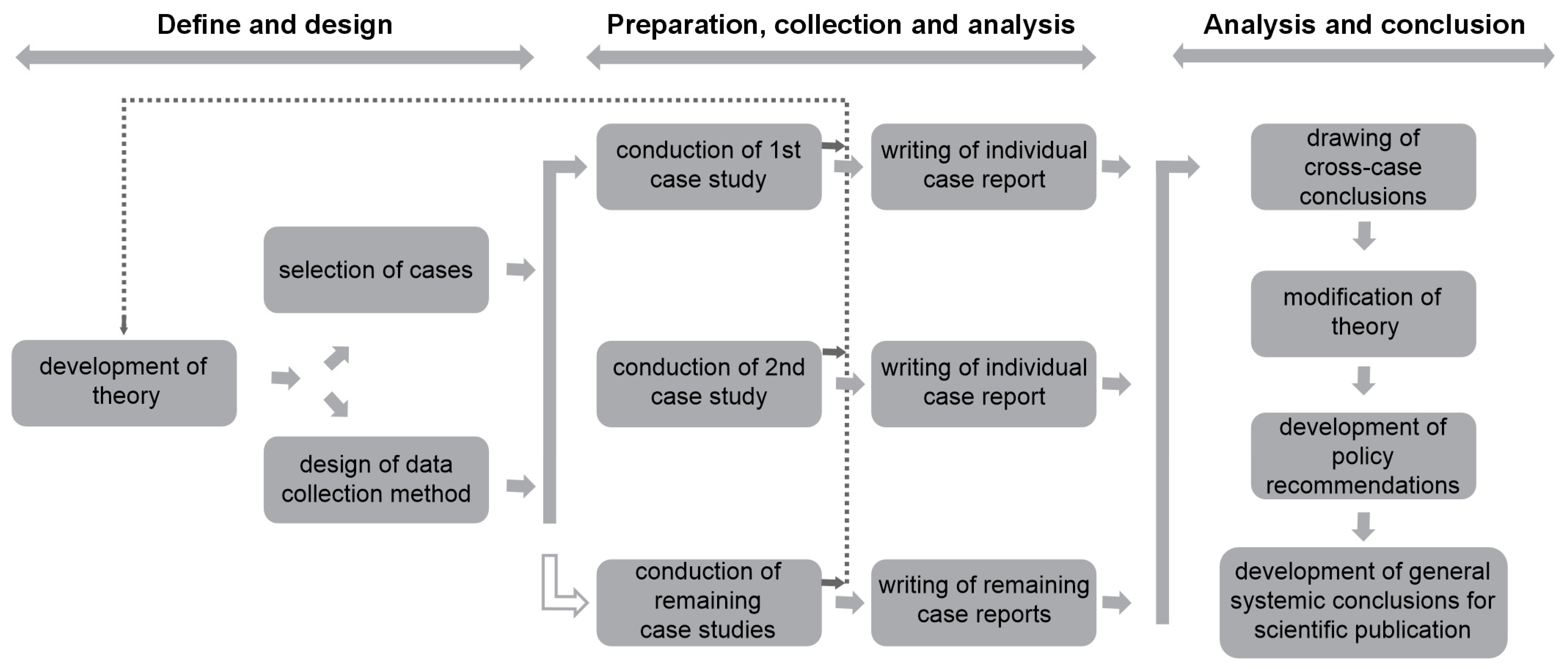
3. Methods and Case Study Analysis

3.1. Methodology

To research the temporary use of space in degraded areas, a plural case study methodology was applied (Figure 1). Based on multiple case studies, the differences in approaches to spatial development processes were first analysed. Each case was analysed in relation to the context in which the spatial implementation process was carried out and what effects the temporary use of space triggered in its surroundings. Special attention was paid not to physical redevelopment of the degraded area but to social effects in local communities. On these bases, potential additional socio-environmental indicators were proposed, which could be used by interested actors (inhabitants, users, visitors, services, authorities) to evaluate the suitability of degraded urban areas for reactivation through temporary use of space.
The plural case study methodology appears as a research strategy or as a path that leads to the gradual structuring of knowledge that actively builds its theoretical–epistemological foundations and does not rely on already built assumptions [96] (p. 19). Instead it actively supports their formation and development from the very start, which is embedded in specific research circumstances and environmental contexts. The case studies are therefore not limited to the deductive explanation of established concepts in spatial planning but help to form new, upgraded versions that are combined into new, inductively formed approaches. The latter is explained by the “method of constant comparison” [96] (p. 19), which can be used to analyse the differences, similarities and peculiarities of the investigated phenomena. Case studies of degraded areas with temporary use of space were collected on the basis of the criteria of a differentiated ownership structure of the area, location, type of temporary use of the space, time (duration) component and context of the implementation of temporary use of space (formal or informal). The differences between the cases was therefore the basis for the comparison and evaluation of effects through which we created a synthesis of results on which we proposed the upgrade of socio-ecological indicators.
Figure 1. Case study research design and procedure. Source: [97,98].
Sustainability 17 05224 g001
The analysis used four cases from Portugal and Slovenia. Two cases were selected from each country. The selection criteria for the case studies lie in the similar levels of socio-economic development of Portugal and Slovenia. Despite specific cultural differences arising from the broader historical context (colonial–non-colonial past, past political order shifts etc.), the countries can be placed in a similar wider systemic environment within the context of current economic development and political relations of the EU. The second reason is that, despite socio-economic similarities, the countries originate from distinctively different spatial planning traditions after the Second World War (eastern (post-socialist) vs. western (liberal economic)), which creates the conditions for comparison and potential identification of common characteristics, which is the goal of the research. In other words, through the analysis, we wanted to obtain data that crosscut through comparable yet, in some features, distinctive state–cultural–economic contexts in order to control the parameters of research.
The primary data in the form of semi-structured interviews and visual (photo) materials from participant observation were supplemented by secondary data from the study of the literature and other scientific sources or databases. The data in all four cases on temporary use of space comprise a random sample of semi-structured interviews with actors or premise users evenly dispersed across the location of the study. The questionnaire was divided into four sections, including the sections on contextual locational characteristics of the area, social networks, demography and GDPR. The whole form included 28 open questions. The questionnaire was pretested by 10 interviewees consisting of experts and random citizens. Data collection for the tobacco factory was divided into two stages of the Urban Education Live research [99], which was conducted over an extended period of time. In the first phase, which lasted from April to August 2018, 31 interviews within different stakeholder groups were conducted. In the second phase, which lasted from January to April 2020, another 30 interviews were gathered, for a total of 61 interviews. In the case of the LX Factory in Lisbon and Prisão Paraíso in Trafarii (both located in Portugal), and the case of the project “Beyond Construction Site” in Ljubljana (Slovenia), a total of 36 semi-structured interviews were collected (thus, 12 per location) in the period from 2017 to 2022. The interviews were conducted in each of the four locations using a random sample of people who either work or use the facilities on selected locations. The weighting of the interviewed groups was based on the concept of equitable geographic distribution throughout the areas (to reflect the use of diverse structures, functions and services in the locations). Nonetheless, the tobacco factory sample and the other three samples differed in a few ways. A wide range of stakeholder groups, including staff members of non-governmental organisations, public institutions and innovative enterprises, were included in the analysis of the tobacco factory case. With few exceptions, the tobacco factory area is largely a mixed business, craft and cultural area that has no permanent residents. The predominant groups of interviewees were consequently deeply engaged with the activities in the selected area. In the case of the LX Factory, Prisão Paraíso and the project Beyond Construction Site, the semi-structured interviews were performed with representatives of owners, formal authorities and civil (local community) groups being evenly represented in the sample.
The interviews conducted at each of the four sites were designed to allow for the examination of specific social network components in connection to the selected areas. It was exactly because of this combination of socio-spatial analysis that methodologies other than interviews were required to supplement the process of research. To support the interviews, a mix of different qualitative methods (participant observation, field observation, cognitive mapping, etc.) was therefore used, the combination of which was expected to provide a credible outline of the connections between the spaces and their meanings for the various actors. The use of multi-layered data enabled cross-checking and validation of the case study findings and significantly contributed to greater reliability of the research. The article’s applied methodology, which combines gathered primary and secondary data, is best described as either the “grounded theoretical approach” [100,101] or the “mixed research methodology” approach [97,102], which synthesises different types of data to produce a more general theory.

3.2. Analysing the Limited Range of Current Sets of Indicators for Temporary Use of Space in Degraded Areas

The majority of existent models that try to identify the main characteristics of degraded areas with temporary uses of space prevalently relate to physical factors. In this regard, the matrix of indicators for temporary use generally includes a strong set of physical factors, which are supplemented by smaller sets of social factors. Such models thus tend to mix social and environmental factors but put significantly more weight onto physical characteristics of areas and much less focus on social factors, which are more used as a supplement or a form for legitimisation of the supposedly holistic structure of the model. In other words, the majority of models may on a declarative level include a heterogeneous structure of socio-ecological indicators but do not go particularly deep into the analysis of the social effects of temporary uses of space. This problem of deficient deep social immersion or absence of micro-social factors when addressing peculiar aspects of temporary use of space is relevant as it shapes the approach to spatial planning. The limited range of social immersion means that the factors are more directed towards the analysis of physical, superficial, incremental sets of material elements on locations. Incrementalism in the use of particular sets of indicators can be perceived as an effort to produce quick but limited amount of data and information for investors and planners to speed up the spatial planning actions [103,104,105,106].
From the literature [93,98,107,108,109,110], it is possible to identify models that produce limited socio-environmental analysis of potential temporary uses of space in degraded areas. These models most often operate within the domain of four categories of indicators that include as follows:
  • The evaluation of FUNCTIONAL DEGRADATION or abandonment of the space by users (for example, the degree of abandonment in relation to the presence of operational services, maintenance of infrastructure, evaluation of traffic accessibility, fluctuation of consumers; it may include some partial statistical indicators on social degradation like vandalism or presence of crime, ghettoization, etc.)
  • The evaluation of PHYSICAL DEGRADATION, including environmental and historic–cultural conservation degradation in relation to protection regimes (includes indicators that evaluate the level of environmental degradation according to specific natural elements, like, for example, the activity, influence on water, soil, air, vegetation, surface or physical degradation of built environment and elements under historical–cultural protection, etc.)
  • The evaluation of other influential SPATIAL FRAMING INDICATORS that define, shape and put limits to the use of space in question (such as time of abandonment, size of the area (net floor area of the area or facility), ownership distribution according to particular owners, etc.)
  • The evaluation of STRATEGIC SPATIAL PLANS FOR THE DEVELOPMENT of the location in relation to investors and formal authorities (in the analysis are included, for example, documents, formal data related to strategic planning (land planning, purpose use) at the level of state, region, municipality, investors, etc.)
These four general categories of indicators are formed from numerous sub-indicators, which can be further deconstructed into additional layers of information or sub-sub-indicators that point to the precision with which we want to address the subject of contextuality in socio-spatial analysis. Some of the sub-indicators belonging to more general categories are presented in Table 1, while a few examples of further or refined elaboration of specific sub-indicators into layers of particular information (sub-sub-indicators) are presented in Table 2.
The sub-indicators (Table 1) and sub-sub-indicators (Table 2) allow us to further detect the presence of specific elements that are by various interest groups perceived as important for evaluating the degraded area’s potential for the introduction of particular temporary use. The sub-indicators outline spatial, environmental and also some basic social conditions in the degraded area, which are important for the subsequent evaluation and decision-making process regarding the revival of the area through temporary use of the space. Some of the sub-indicators can be then further dissolved into additional layers of information structured in sub-sub-indicators which provide even more particular information on specific spatial elements connected to the degraded area intended for potential temporary use.
During the process of the evaluation of a degraded area for potential temporary uses, the presented sub-indicators combine in order to create a more informed snapshot of the situation on terrain for decision makers. However, the presented most frequently used indicators still give just a partial view of a potentially much more complex context that may exist on a selected area. The presented indicators can be illustratively described as “fast-forward indicators” in terms of the quick accumulation of information on terrain in order to make straightforward decisions according to the established goals, plans and investments of decision makers.

3.3. Analysing an Alternative Matrix of Socio-Ecological Indicators for Temporary Uses of Space in Degraded Areas

In the continuation of this article, we will try to show the importance of social information for the potential temporary use of space and long-term development of an area. The intention is to show how the range of socio-environmental indicators in the analysis of temporary use of space should be extended with the inclusion of multiple soft factors and, particularly, social networks as one of their key ingredients.
The so-called “soft location factors”, “soft spatial factors” or simply “soft factors” [83,84,111] are different from hard factors, which describe the physical elements of an area. They typically include other contextual elements that enhance social aspects in specific environments and contribute to establish the ecosystem that produces urban influences that trespass to the wider scale of the city. Soft spatial circumstances are frequently used to describe the broader aspect of social networks, which encompass personal connections, professional and social networks, and other local social groups associated with individuals’ life trajectories [112]. It is important to highlight that we acknowledge that “being embedded in a place is mainly being embedded in personal networks and when analysing personal networks we refer to the sets of links people create in certain places during their life trajectory” [85] (p. 357).
Social networks can be thus embedded within specific spatial situations and may constitute an important form of social capital of an area that contributes to the functioning of the wider area and city economy in general. If this type of capital becomes lost during the process of transformation, it can have detrimental effects not only for the temporary users of the area but also translate into the obstruction of city development.
In the next two subsections, we will first look into the detailed analysis of specific social factors in the case of the tobacco factory in Ljubljana to show the complexity of temporary use of space. This subsection will, in the second part, be followed by a more general overview of multiple cases of temporary use of space in order to support the argumentation that points to the need for a more complex analysis of the temporary use of space in present spatial planning procedures.

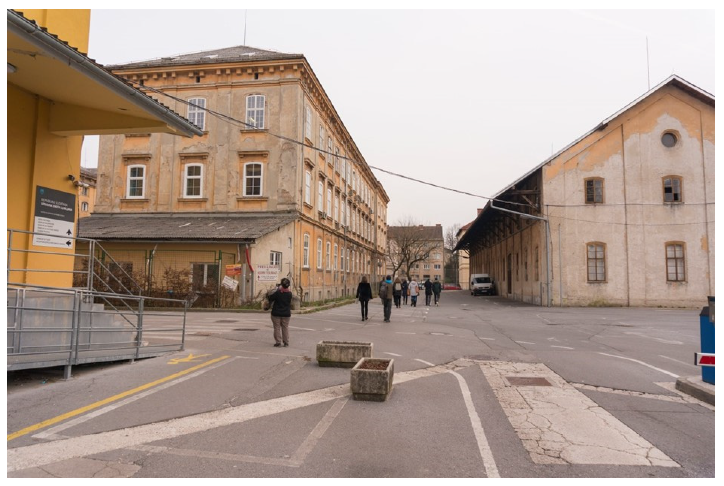
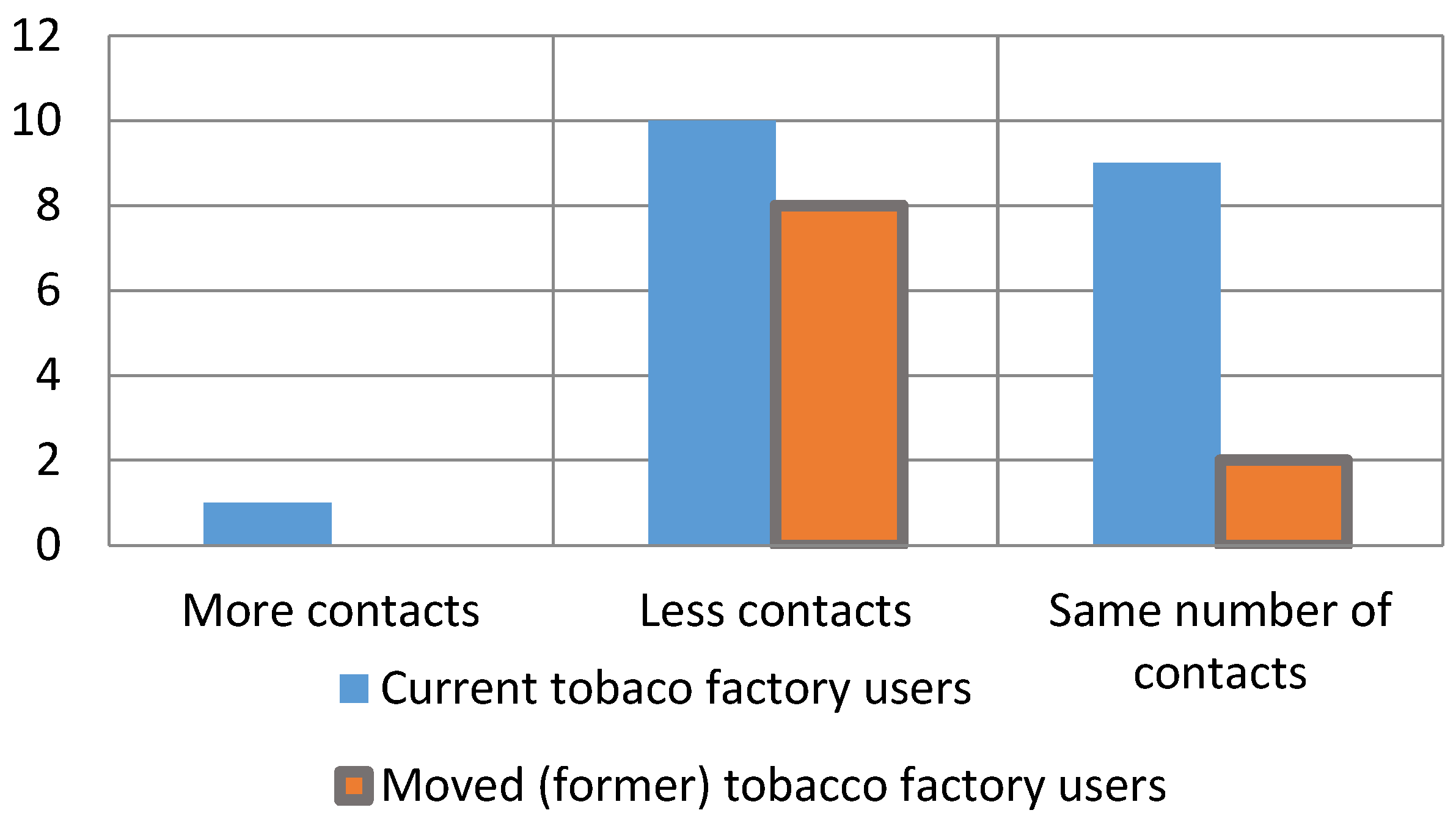
3.3.1. The Case of Tobacco Factory in Ljubljana

The first case of the tobacco factory (built between 1871 and 1890 in Ljubljana) presents the measurement of specific soft factors in temporary uses of space that are usually not included in the long-term plans of the development of an area. Following decades of diverse industrial development, the tobacco factory complex’s ownership structure underwent significant changes in 1991, which resulted in the gradual cessation of tobacco product production and the implementation of a number of short-term uses for the space (Figure 2). In 1991, the area was populated by a wide range of players, including artists, NGOs, cultural societies, small business owners and independent contractors. The tobacco factory area, known as “Tobačna tovarna” in Slovene, had more than 400 small businesses with an average of two to three employees, according to data gathered from databases of standard classifications of activities [113]. The Tobacco Museum, a gallery, the Poligon Creative Centre, the Hekovnik Institute, design and architectural studios, several non-governmental organisations, start-ups and art institutions, as well as a variety of administrative services and numerous other organisations, societies and businesses associated with creative production, were among the many activities that took place on the premises. According to the Creative Cities survey [114,115], the area is one of Slovenia’s most dynamic in terms of the quantity and diversity of small creative businesses (SMEs). When a private investor purchased the entire Tobačna neighbourhood in 2019, they broke off ties with the majority of the building’s prior short-term tenants.
In the analysis of social networks in the former area of the tobacco factory, the suspension of temporary activities that had been gradually redeveloping the area for thirty years raised a number of questions about the former users, their functions and the impact that the area’s abolition has on the functioning of the larger socio-economic ecosystem of Ljubljana.
According to the gathered information, individuals in the area of the tobacco factory typically had a wide variety of social networks. The development of creative activities was significantly impacted by formal networks, which are defined as working, project and contractual connections (a client–contractor relationship). However, informal networks, which are based on friendly ties and manifest in socialising, spending free time during breaks, lunches, walks, drinking coffee and so on, were also of huge importance and significantly complemented the formal networks. Interview results revealed that respondents’ length of time in the tobacco factory area had a significant impact on the depth or intensity of their social networks. As with earlier social network analyses [116,117,118], the findings show that the time length variable, or process duration, plays a crucial influence. In this way, the number and diversity of a person’s networks were dependent upon the duration of specific processes associated with specific places (social nodes). The interviews further confirmed the significance of informal interactions in the context of socio-economic activity clustering. As the creative ecosystems demand a higher level of interpersonal trust, informal contacts represented fundamental communication channels that helped build and strengthen the creative production in the area. They also facilitated a greater exchange of tacit information about how the tobacco factory ecosystem operated. The higher the number of years in the area would according to this empirical observation correspond to greater number and diversification of an individual’s formal and informal networks in the Tobacco factory (Figure 3).
The number of spaces in the interviewees’ “mental maps” [119] increased exponentially with the number of years spent in the tobacco factory area. These spaces included social nodes for both formal and informal socialising in the tobacco factory area (the most popular social nodes were restaurants, bars and entrances in front of the main buildings). Given the significance of social networks for socio-economic clustering, the study demonstrated that the length of time spent in the tobacco factory area also affected the development of new formal social connections there, which were subsequently translated into different types of contractual business cooperations. The number of contractual business relationships grew together with the amount of years spent in the area. The respondents acquired 3.5 new contacts on average. During their time working in the tobacco factory area, the interviewees made an average of 3.5 new contacts.
Formal and informal relationships were thus evaluated in respect to a time variable, demonstrating how social capital emerged in the tobacco factory area over time and manifested in social networks through a variety of businesses, social events and commercial contacts. It should be highlighted that the social capital that has accumulated in the area is deeply entwined with the specific contextuality emerging from the merger of unique physical, cultural and social characteristics on the location. One could characterise it as a principle of the “social production of space” [120] (pp. 299–346), according to which the social structure of space becomes undetachable from space as a physical category. The significance of the temporal component of space production is highlighted, suggesting that based on particular uses (spatial practices, presentation of space, spaces of representation and collective experience), a new space that defies easy definitions of a physical environment with aesthetic value emerges over time [120]. The type, duration and role of social networks in an area in this regard represent the corner stone of social sustainability. The case of the tobacco factory shows that it is possible to measure the impact of spatial interventions in an area according to the consequences it has on the full spectrum of formal and informal social networks. From here, it is possible to elaborate on a different and innovative approach to contextual analysis in temporary use of space that breaks with the tradition of classical spatial contextual analysis that focuses on physical factors.
The process of spatial development becomes simplified if the production of a space is limited to the physical changes made to it and ignores other types of (social) values that have emerged in the area. This results in a decrease in social networks, social capital and capacity for long-term social sustainability in the area. This was revealed in the context of the tobacco factory when comparing the interview data for the years prior to restructuring (in 2018) and following the sale of the area (in 2020), which subsequently resulted in the closure of most of the socio-economic activity in the area. The volume of all examined dimensions of formal and informal networks as well as business (contractual) contacts has drastically decreased since the sale of most of the area, leaving only one building open for socio-economic activity. For instance, the index of newly formed social connections decreased from an average of four connections to roughly one new connection during the comparable period between 2018 and 2020 (Figure 4).
According to the data, the growth of social networks has been severely constrained by the closure of the majority of social nodes in the area. It may be argued that the drastic spatial transformation process logically prevented any further growth of social networks in the area undergoing complete restructuring of functions, services and activities. However, it is also important to note the general shrinkage of social networks that was caused by the forced relocation of some creative actors from the tobacco factory site to other locations throughout the city. More precisely, while the economic actors who moved away or stayed in the tobacco factory area reported that they had made some new contacts in the new environment, they also explained that, compared to prior years, the number and frequency of their daily connections in the social networks of formal and informal contacts had decreased. Both present and past tobacco factory users concurred that the area’s reorganisation impacted how frequently they met, collaborated and interacted with other tobacco factory users (Figure 5).
This longitudinal research allowed for a comparison of the altered social networks of the tobacco factory area’s present users and those of the previous users who were compelled to relocate after the ownership change. Approximately one-third of the 30 individuals interviewed in 2020 belonged to the latter category. Due to the potential for comparison with 2018, this set of respondents was especially intriguing because of the significant decline in their social networks following their relocation from the tobacco factory area. The data indicate that attempts at separating social networks (by eviction or relocation) from the local context or milieu have had a significant impact on their scope and functionality, despite the fact that social networks are fundamentally based on intangible connections and are not directly related to physical parameters or visible bases. This highlights the significance of the social production of space, where intricate dependencies and communication relationships between creative players have developed over several years. When this process is hindered, the socio-economic ecosystem’s volume decreases, which means that the city’s capacity for social sustainability on the long-term scale has diminished and additional collateral costs will be incurred. These cost can be identified both in the lost financial resources and lost time needed to rebuild comparable socio-economic networks in other parts of the city. It is impossible to predict how many years and financial resources will be needed to create comparable new hubs and rebuild social networks in the socio-economic ecosystem of small businesses, which promote local community development but are also in a disadvantaged position due to the unforgiving market conditions that require short-term capital maximisation.
The case of the tobacco factory exposes the need for new socio-ecological indicators that allow in-depth analysis of soft (social) factors that might exist in temporary use of space in degraded areas. The measurement of social networks is, in this regard, a typical socio-ecological indicator that is in the majority of cases of spatio-environmental redevelopment deliberately neglected due to its complex analysis and consequently potential prolongation of spatial planning procedures. In the next section, a general analysis is presented of a few additional examples of temporary use of space in degraded areas that detects the problematic gap between the use of physical–environmental and socio-ecological indicators in spatial development procedures.

3.3.2. General Case Studies on Temporary Use of Space in Degraded Areas

The section presents three general case studies focusing on the temporary use of space in degraded areas, with the goal of analysing and contrasting different approaches to urban revitalisation. The selected cases, the LX Factory in Lisbon, Prisão Paraíso in Trafarii (both located in Portugal) and the “Beyond Construction Site” in Ljubljana (Slovenia) project in Ljubljana, represent distinct socio-economic and spatial contexts, offering a multi-scalar perspective on the management of temporary space, community involvement, and the application of socio-ecological indicators in redevelopment processes.
The case studies not only illustrate the diversity of strategies for temporary use but also highlight key differences in the intensity and effectiveness of integrating social and ecological considerations into redevelopment frameworks. Each case is analysed through four key dimensions: the history of the degraded area, its temporary use, the nature of the redevelopment process and the inclusion of socio-ecological indicators, with a particular focus on the preservation and transformation of social networks after the temporary use ends. These dimensions formed the basis for a qualitative analysis of interviews with stakeholders, identifying broader narratives on how different models of temporary use have influenced spatial transformation and social dynamics.
More importantly, the cases underscore the role of different management styles, top-down, bottom-up or a mix of both, in shaping the sustainability and legacy of temporary interventions. These management styles significantly influence the long-term functionality of communities, quality of life and even local economies, as evidenced by comparable processes observed in large-scale redevelopments such as the LX Factory in Lisbon. The discussion thus opens a broader reflection on the adequacy of current spatial planning indicators, which often rely heavily on physical metrics, and calls for a stronger integration of socially grounded indicators. Table 3 summarises the main characteristics of each case across the four analytical dimensions.
The three cases illustrate the differences in approaches to the temporary use of space and open additional insights into the debate on the adequacy of existent prevalently physical indicators in procedures of spatial planning. The three cases point not only to differences in the intensity of use of socio-ecological indicators in the redevelopment process but above all show different management styles (top-down or bottom-up) that either more or less integrate social dimensions into the spatial planning procedures. Different management styles of temporary use of space in degraded areas can have long-term effects on the functioning of communities and potential repercussions not only for the local quality of the life in the area but, as the case of the tobacco factory showed, also the economy of the cities. The case of the tobacco factory in this regard combines with the three illustrative cases and opens the debate on long- and short-term effects, which result from the use of limited spatial development indicators.

4. Conclusions—Optimising the Model of Socio-Environmental Indicators for Temporary Uses of Space in Degraded Areas

The study on the temporary use of space in degraded areas opens important new research streams that reach beyond classical notions of spatial planning. It provides chances for a thorough comprehension of social and cultural impacts, the development of possible new governance models and integration of these practices into more comprehensive plans for socially responsible urban growth. In this regard, the study is a rare interdisciplinary attempt to construct a conceptual platform from which it is possible to bridge the gap that exists between declarative and applicative use of social practices in spatial planning. Although the study stresses the importance of in-depth contextual analysis, it is precisely this contextuality that puts limits on the study in terms of the generalisation of results. The study has limitations in terms of the generalisation of results in regard to other environments due to its small sample. In order to extend the value of the results to the global scale, a wider sample of locations and stakeholder groups that allows more detailed insights into specific socio-cultural systems of states and global regions should be implemented.
  • The scientific value of the performed research study lies in its innovative approach that connects the concept of social sustainability with temporary use of space and consequently addresses potential new approaches in spatial planning that may stem from it. These new, flexible approaches integrate the contextual analysis of social networks into spatial planning as part of necessary socio-ecological indicators that are now markedly deficient (see Table 1).
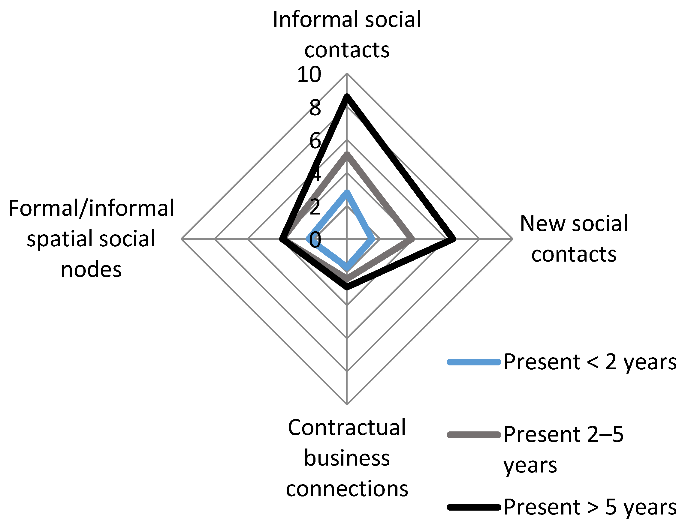
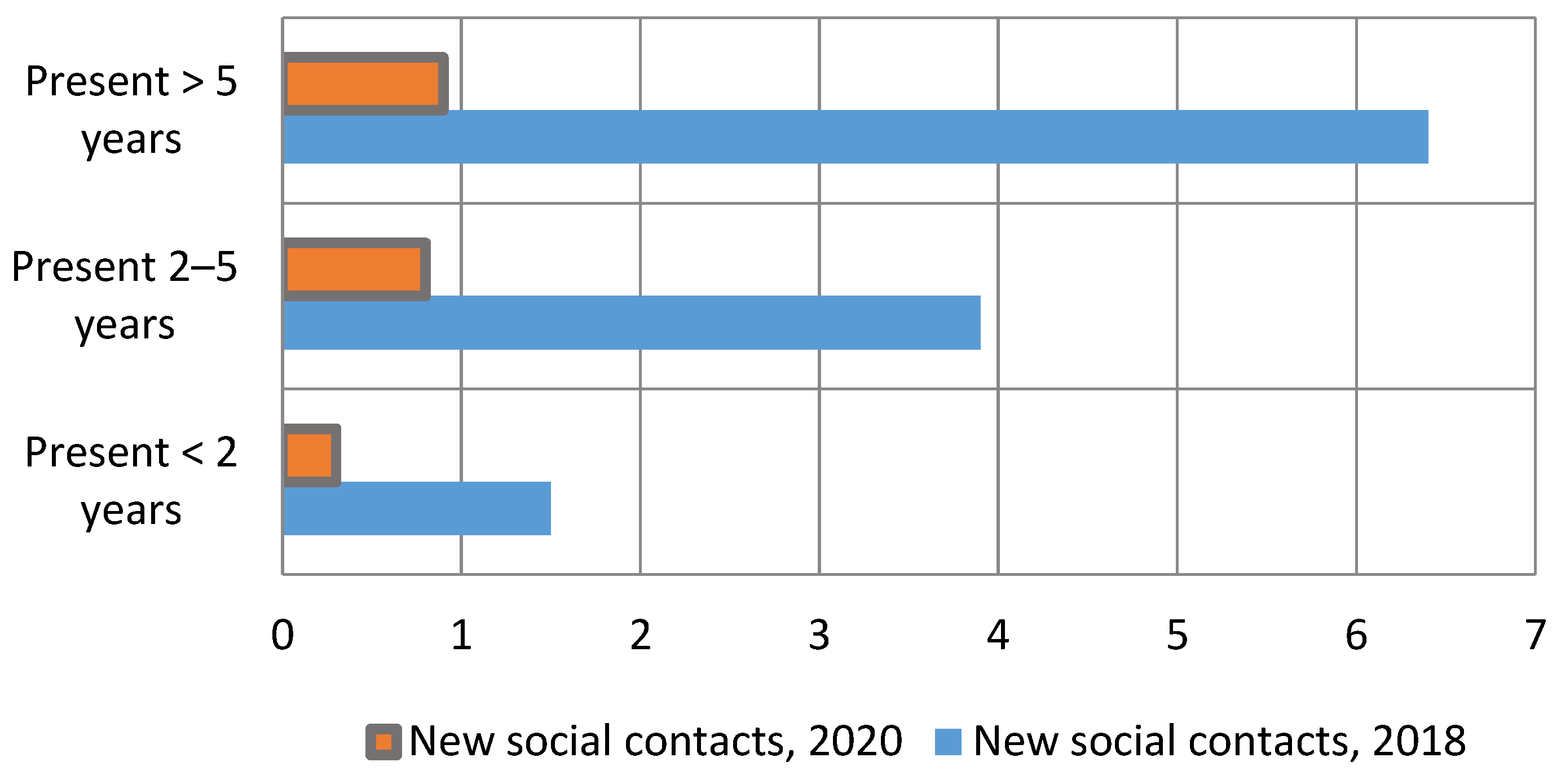
  • Scientific value can be found also in the new model of innovative critical reflection that uses social networks in temporary use of space as detectors for analytical deficits in spatial planning (see Figure 3, Figure 4 and Figure 5). This model based on the analysed tobacco factory can be applied (replicated) to other spatial procedures found across the whole spectrum of the EU planning system that in the majority of cases, exclude more detailed elaboration of socio-ecological indicators that would use/analyse the type, duration and role of social networks as the standardised principle of spatial planning. The study in this regard elaborates on specific phases at which the classical spatial planning approaches produce deficits in contextual spatial analysis and resort to fast-forward indicators.
  • The empirical section allows the replicability of the analytical model in terms of social network analysis in temporary use of space. In particular, the case of the tobacco factory exposed the necessary dimensions of the type, duration and role of social networks that should be taken into analysis. In terms of the replicability and standardisation of analytical process, each location is case specific and should be adapted accordingly. However, the main elements of analysis are exposed and when adequately used or integrated into spatial planning, each of these factors can significantly influence the perception of decision makers regarding the need for inclusion, participation of specific groups that during the period of temporary use helped develop the areas through their physical work, development of local economies, use of services and other beneficial effects on liveability.
  • The study also presented particular shortcomings in spatial planning that follows a linear one-dimensional approach and paves the way for collateral damaging processes on locations. The empirical section in this regard used socio-ecological indicators to provide new insights into particular problems of the management of temporary uses of space in degraded areas that extend beyond the selected locations of the LX Factory, Prisão Paraíso and Beyond Construction Site. For example, the problems associated with gentrification, diminishment of the quality of life and reduced resilience of local economies in contemporary cities are deeply connected to deficits in socio-spatial locational analysis within the processes of spatial planning [3,5,15].
  • Last but not least, the shift in urban governance should be preceded by the shift in the use of tools and mechanisms that support more sustainable processes of spatial transformation [9,86,87]. An alternative perspective on urban planning that is grounded in promoting social justice, equality and a higher standard of living in addition to material resources should be taken into account. For this reason, current approaches that try to quantify the social and cultural worth of a particular productive ecosystem on site are typically associated with short-term economic models rather than social ones. Techniques for “measuring non-monetary values” [121] (p. 436), or non-material, intangible values in a particular area, should receive more attention because it appears that certain significant aspects of a productive ecosystem may be overlooked when employing a superficial evaluation scheme.
Regardless of these shortcomings, the analysis adequately identified key elements and characteristics of social sustainability and connected them to the field of temporary use of space in spatial planning. This represents a novelty in regard of approaches that try to develop new traits in contextual analysis of spatial planning. The analysis used various layers of data to present shortcomings in the use of socio-ecological indicators when it comes to temporary use of space in degraded areas [121]. Better integration of socio-ecological indicators within spatial planning would allow the identification of the main local socio-spatial contextual characteristics for the optimal use of resources on terrain to generate the reactivation of degraded areas in local communities. The study points to the need for the development of new methodologies and indicators to evaluate the impact of various groups of inhabitants, users, visitors in terms of quality of life, skills enhancement, and the development of a milieu and social inclusion. To do that, the task is first to identify different kind of values that exist on a specific locality and connect them to the redevelopment process. Optimal spatial development operates at the intersections between values, emotions, culture, economy and other spheres of everyday life. Due to this, fluid borders of both tangible and intangible impacts will have to be measured to provide a good assessment of the socio-environmental impact on location. Therefore, the issue with today’s spatial planning models is not that they can create short-term, physical effects in degraded areas, but rather that they are unable to systematically identify and permit the integration of social sustainability elements that are essential for the long-term development, preservation and maintenance of such places.

Author Contributions

Conceptualization, M.U. and T.C.; methodology, M.U. and T.C.; software, M.U. and T.C.; validation, M.U. and T.C.; formal analysis, M.U.; investigation, M.U. and T.C.; resources, M.U. and T.C.; data curation, M.U. and T.C.; writing—original draft preparation, M.U.; writing—review and editing, M.U. and T.C.; visualization, M.U. and T.C.; supervision, M.U. and T.C.; project administration, M.U. and T.C.; funding acquisition, M.U. and T.C. These authors contributed equally to this work. All authors have read and agreed to the published version of the manuscript.

Funding

The article was supported by the HEI-TRANSFORM project, part of the research scheme of the Slovenian Research and Innovation Agency (ARIS, project title: “Heritage for Inclusive Sustainable Transformation—HEI-TRANSFORM”; code: J7-4641).

Institutional Review Board Statement

Ethics Committee on Research at the Faculty of Social Sciences, University of Ljubljana 801-2025-007/TD 2025-04-14.

Informed Consent Statement

Informed consent was obtained from all subjects involved in the study.

Data Availability Statement

The data supporting the findings of this study are available from the corresponding author upon request.

Conflicts of Interest

The authors declare no conflicts of interest.

References

  1. Colomb, C. Pushing the Urban Frontier: Temporary Uses of Space, City Marketing, and the Creative City Discourse in 2000S Berlin. J. Urban Aff. 2012, 34, 131–152. [Google Scholar] [CrossRef]
  2. Bishop, P. From the Subversive to the Serious: Temporary Urbanism as a Positive Force. Archit. Des. 2015, 85, 136–141. [Google Scholar] [CrossRef]
  3. Ferreri, M. The Seductions of Temporary Urbanism “Saving” the City: Collective Low-Budget Organizing and Urban Practice. Ephemera 2015, 15, 181–191. [Google Scholar]
  4. Madanipour, A. Temporary Use of Space: Urban Processes between Flexibility, Opportunity and Precarity. Urban Stud. 2018, 55, 1093–1110. [Google Scholar] [CrossRef]
  5. Stevens, Q.; Dovey, K. Temporary and Tactical Urbanism: (Re)Assembling Urban Space; Routledge: New York, NY, USA; London, UK, 2023; ISBN 978-1-032-25653-5. [Google Scholar]
  6. Urban Catalyst: The Power of Temporary Use; Oswalt, P., Overmeyer, K., Misselwitz, P., Eds.; DOM Publishers: Berlin, Germany, 2013; ISBN 978-3-86922-261-5. [Google Scholar]
  7. Crowther, P. Temporary Public Spaces: A Technological Paradigm. J. Public Space 2016, 1, 63. [Google Scholar] [CrossRef]
  8. Honeck, T. From Squatters to Creatives. An Innovation Perspective on Temporary Use in Planning. Plan. Theory Pract. 2017, 18, 268–287. [Google Scholar] [CrossRef]
  9. Schuster, M. Ephemera, Temporary Urbanism, and Imaging. In Imaging the City; Routledge: New York, NY, USA, 2001; pp. 361–396. ISBN 978-0-429-33521-1. [Google Scholar]
  10. Inti, I. Che Cos’ è Il Riuso Temporaneo? Territorio 2011, 2011, 18–42. [Google Scholar] [CrossRef]
  11. Pruijt, H. Is the Institutionalization of Urban Movements Inevitable? A Comparison of the Opportunities for Sustained Squatting in New York City and Amsterdam. Int. J. Urban Reg. Res. 2003, 27, 133–157. [Google Scholar] [CrossRef]
  12. Roy, A. Urban Informality: Transnational Perspectives from the Middle East, Latin America, and South Asia; Roy, A., AlSayyad, N., AlSayyad, N., Eds.; Transnational Perspectives on Space and Place; Lexington Books: Lanham, MD, USA, 2004; ISBN 978-0-7391-0741-6. [Google Scholar]
  13. Langegger, S. Rights to Public Space Law, Culture, and Gentrification in the American West; Softcover Reprint of the Original 1st Edition 2017; Springer International Publishing Palgrave Macmillan: Cham, Switzerland, 2018; ISBN 978-3-319-82286-0. [Google Scholar]
  14. Lydon, M.; Garcia, A. Tactical Urbanism: Short-Term Action for Long-Term Change; Island Press/Center for Resource Economics: Washington, DC, USA, 2015; ISBN 978-1-59726-451-8. [Google Scholar]
  15. Andres, L.; Zhang, A.Y. Transforming Cities Through Temporary Urbanism: A Comparative International Overview; The Urban Book Series; Springer International Publishing: Cham, Switzerland, 2020; ISBN 978-3-030-61752-3. [Google Scholar]
  16. Frediani, A.A.; Cociña, C. “Participation as Planning”: Strategies from the South to Challenge the Limits of Planning. Built Environ. 2019, 45, 143–161. [Google Scholar] [CrossRef]
  17. Galdini, R. Temporary Uses in Contemporary Spaces. A European Project in Rome. Cities 2020, 96, 102445. [Google Scholar] [CrossRef]
  18. Högyeová, M.; Agócsová, Á.; Hajduk, M.; Gažová, D. The Role of Temporary Use of Public Space in Sustainable Development: A Case Study. Period. Polytech. Soc. Manag. Sci. 2023, 31, 100–111. [Google Scholar] [CrossRef]
  19. Healey, P. Planning in Relational Space and Time: Responding to New Urban Realities. In A Companion to the City; Bridge, G., Watson, S., Eds.; Wiley: Hoboken, NJ, USA, 2003; pp. 517–530. ISBN 978-0-631-21052-8. [Google Scholar]
  20. Forester, J. The Deliberative Practitioner: Encouraging Participatory Planning Processes; 2. Print.; MIT Press: Cambridge, MA, USA, 2000; ISBN 978-0-262-56122-8. [Google Scholar]
  21. Kostaki, E.; Frangopoulos, Y.; Makridou, A.; Kapitsinis, N. Participatory Governance for the Temporary Use of Urban Abandoned Areas. A Socio-Spatial Approach to the “Old Hospital” Area in Alexandroupolis, Greece. Cities 2024, 154, 105378. [Google Scholar] [CrossRef]
  22. Deleuze, G.; Guattari, F. City State. In ZONE 1/2: The Contemporary City; Urzone, Incorporated: New York, NY, USA, 1986; pp. 1–2, 194–199. ISBN 0-942299-22-1. [Google Scholar]
  23. Amin, A.; Thrift, N. Cities: Reimagining the Urban; Polity: Cambridge, UK, 2002; ISBN 978-0-7456-2413-6. [Google Scholar]
  24. Hillier, J. Stretching Beyond the Horizon, 1st ed.; Routledge: London, UK, 2017; ISBN 978-1-351-89750-1. [Google Scholar]
  25. Castells, M. The Rise of the Network Society, 1st ed.; Wiley: Hoboken, NJ, USA, 2009; ISBN 978-1-4051-9686-4. [Google Scholar]
  26. Latour, B. Reassembling the Social: An Introduction to Actor-Network-Theory; Clarendon Lectures in Management Studies; 1. publ. in pbk.; Oxford University Press: Oxford, UK, 2007; ISBN 978-0-19-925605-1. [Google Scholar]
  27. Bauman, Z. Liquid Modernity; Polity Press: Cambridge, UK; Blackwell: Malden, MA, USA, 2000; ISBN 978-0-7456-2409-9. [Google Scholar]
  28. Bauman, Z. Globalization: The Human Consequences; Reprint; Columbia University Press: New York, NY, USA, 2001; ISBN 978-0-231-11429-5. [Google Scholar]
  29. Urry, J. Sociology Beyond Societies: Mobilities for the Twenty-First Century; International Library of Sociology; Transferred to Digital Printing; Routledge: London, UK, 2006; ISBN 978-0-415-19089-3. [Google Scholar]
  30. Simonsen, K. Networks, Flows, and Fluids—Reimagining Spatial Analysis? Environ. Plan. Econ. Space 2004, 36, 1333–1337. [Google Scholar] [CrossRef]
  31. Partnership on Circular Economy and Sustainable Land Use. Handbook—Sustainable and Circular Re-Use of Spaces and Buildings. 2019. Available online: https://ec.europa.eu/futurium/en/system/files/ged/sustainable_circular_reuse_of_spaces_and_buildings_handbook.pdf (accessed on 14 May 2025).
  32. Kasperczyk, Z.; Pazder, D. Komercyjne Tymczasowe Użytkowanie Przestrzeni Jako Narzędzie Kreowania Współczesnego Środowiska Mieszkaniowego—Szanse i Zagrożenia. Śr. Mieszk. 2022, 39, 53–65. [Google Scholar] [CrossRef]
  33. Offe, C. The Utopia of the Zero-Option. Modernity and Modernization as Normative Political Criteria. Prax. Int. 1987, 7, 1–24. [Google Scholar]
  34. Beck, U. Risk Society: Towards a New Modernity; Theory, Culture & Society; Sage Publications: London, UK; Newbury Park, CA, USA, 1992; ISBN 978-0-8039-8345-8. [Google Scholar]
  35. Giddens, A. The Consequences of Modernity; Polity Press: Cambridge, UK, 1990; ISBN 978-0-7456-0923-2. [Google Scholar]
  36. Mariano, C.; Gràvalos Lacambra, I.; Di Monte, P. Open Urban Space Regeneration Strategies Based on Urban Welfare: A Project and Experiment in the San Lorenzo District in Rome, Italy. Sustainability 2022, 14, 16487. [Google Scholar] [CrossRef]
  37. Lefebvre, H.; Nicholson-Smith, D.; Lefebvre, H. The Production of Space; 33. Print; Blackwell Publishing: Malden, MA, USA, 2013; ISBN 978-0-631-18177-4. [Google Scholar]
  38. Marra, G.; Barosio, M.; Eynard, E.; Marietta, C.; Tabasso, M.; Melis, G. From Urban Renewal to Urban Regeneration: Classification Criteria for Urban Interventions. Turin 1995–2015: Evolution of Planning Tools and Approaches. J. Urban Regen. Renew. 2016, 9, 367. [Google Scholar] [CrossRef]
  39. Jaspers, S.; Steen, T. The Sustainability of Outcomes in Temporary Co-Production. Int. J. Public Sect. Manag. 2019, 33, 62–77. [Google Scholar] [CrossRef]
  40. Haydn, F.; Temel, R. Temporary Urban Spaces: Concepts for the Use of City Spaces; Birkhäuser: Basel, Switzerland, 2006; ISBN 978-3-7643-7460-0. [Google Scholar]
  41. Bishop, P.; Williams, L. The Temporary City; Routledge: London, UK; New York, NY, USA, 2012; ISBN 978-0-415-67055-5. [Google Scholar]
  42. Andres, L. Differential Spaces, Power Hierarchy and Collaborative Planning: A Critique of the Role of Temporary Uses in Shaping and Making Places. Urban Stud. 2013, 50, 759–775. [Google Scholar] [CrossRef]
  43. Tardiveau, A.; Mallo, D. Unpacking and Challenging Habitus: An Approach to Temporary Urbanism as a Socially Engaged Practice. J. Urban Des. 2014, 19, 456–472. [Google Scholar] [CrossRef]
  44. Blumner, N. Planning for the Unplanned: Tools and Techniques for Interim Use in Germany and the United States; German Institute of Urban Affairs: Berlin, Germany, 2006; pp. 1–62. [Google Scholar]
  45. Németh, J.; Langhorst, J. Rethinking Urban Transformation: Temporary Uses for Vacant Land. Cities 2014, 40, 143–150. [Google Scholar] [CrossRef]
  46. Mould, O. Tactical Urbanism: The New Vernacular of the Creative City. Geogr. Compass 2014, 8, 529–539. [Google Scholar] [CrossRef]
  47. Webb, D. Tactical Urbanism: Delineating a Critical Praxis. Plan. Theory Pract. 2018, 19, 58–73. [Google Scholar] [CrossRef]
  48. Wohl, S. Tactical Urbanism as a Means of Testing Relational Processes in Space: A Complex Systems Perspective. Plan. Theory 2018, 17, 472–493. [Google Scholar] [CrossRef]
  49. De Certeau, M. The Practice of Everyday Life; University of California Press: Berkeley, CA, USA, 1984; ISBN 978-0-520-23699-8. [Google Scholar]
  50. Deslandes, A. Exemplary Amateurism: Thoughts on DIY Urbanism. Cult. Stud. Rev. 2013, 19, 216–227. [Google Scholar] [CrossRef]
  51. Finn, D. DIY Urbanism: Implications for Cities. J. Urban. Int. Res. Placemaking Urban Sustain. 2014, 7, 381–398. [Google Scholar] [CrossRef]
  52. Iveson, K. Cities within the City: Do-It-Yourself Urbanism and the Right to the City. Int. J. Urban Reg. Res. 2013, 37, 941–956. [Google Scholar] [CrossRef]
  53. Sawhney, N.; De Klerk, C.; Malhotra, S. Civic Engagement through DIY Urbanism and Collective Networked Action. Plan. Pract. Res. 2015, 30, 337–354. [Google Scholar] [CrossRef]
  54. Fabian, L.; Samson, K. Claiming Participation—A Comparative Analysis of DIY Urbanism in Denmark. J. Urban. Int. Res. Placemaking Urban Sustain. 2016, 9, 166–184. [Google Scholar] [CrossRef]
  55. Spataro, D. Against a De-Politicized DIY Urbanism: Food Not Bombs and the Struggle over Public Space. J. Urban. Int. Res. Placemaking Urban Sustain. 2016, 9, 185–201. [Google Scholar] [CrossRef]
  56. Hou, J. Insurgent Public Space: Guerrilla Urbanism and the Remaking of Contemporary Cities; Routledge: New York, NY, USA, 2010; ISBN 978-0-415-77966-1. [Google Scholar]
  57. Hou, J. Guerrilla Urbanism: Urban Design and the Practices of Resistance. URBAN Des. Int. 2020, 25, 117–125. [Google Scholar] [CrossRef]
  58. Rosa, M.; Weiland, U.; Alvarez, A.; Sennett, R. Handmade Urbanism; Jovis: Berlin, Germany, 2013; ISBN 978-3-86859-225-2. [Google Scholar]
  59. Mady, C. Diversity in Conviviality: Beirut’s Temporary Public Spaces. Open House Int. 2012, 37, 63–71. [Google Scholar] [CrossRef]
  60. Webster, C.J.; Lai, L.W. Property Rights, Planning and Markets: Managing Spontaneous Cities; Elgar: Cheltenham, UK, 2003; ISBN 978-1-84064-904-8. [Google Scholar]
  61. Smith, A. ‘Borrowing’ Public Space to Stage Major Events: The Greenwich Park Controversy. Urban Stud. 2014, 51, 247–263. [Google Scholar] [CrossRef]
  62. Ziehl, M.; Osswald, S.; Schnier, D.; Hasemann, O. Second Hand Spaces: Über das Recyceln von Orten im städtischen Wandel; Recycling Sites Undergoing Urban Transformation; Jovis: Berlin, Germany, 2012; ISBN 978-3-86859-155-2. [Google Scholar]
  63. Sandercock, L. Towards Cosmopolis: Planning for Multicultural Cities; J. Wiley: Chichester, UK; New York, NY, USA, 1998; ISBN 978-0-471-97197-9. [Google Scholar]
  64. Groth, J.; Corijn, E. Reclaiming Urbanity: Indeterminate Spaces, Informal Actors and Urban Agenda Setting. Urban Stud. 2005, 42, 503–526. [Google Scholar] [CrossRef]
  65. Krmpotić Romić, I.; Bojanić Obad Šćitaroci, B. Temporary Urban Interventions in Public Space. Prostor 2022, 30, 178–187. [Google Scholar] [CrossRef] [PubMed]
  66. Chowdhury, M.T.A.; Sharma, N. LotRec: A Recommender for Urban Vacant Lot Conversion. arXiv 2022, arXiv:2202.02481. [Google Scholar]
  67. Grávalos Lacambra, I.; Di Monte, P. Temporary Use Toolkit. Herramientas Para La Reactivación de Edificios En Desuso. ZARCH 2024, 132–145. [Google Scholar] [CrossRef]
  68. Agheyisi, J.E. Temporary Use of Urban Vacant Spaces: A pro-Poor Land Use Strategy in the Global South. J. Urban Aff. 2025, 47, 978–1002. [Google Scholar] [CrossRef]
  69. Martin, M.; Deas, I.; Hincks, S. The Role of Temporary Use in Urban Regeneration: Ordinary and Extraordinary Approaches in Bristol and Liverpool. Plan. Pract. Res. 2019, 34, 537–557. [Google Scholar] [CrossRef]
  70. Madanipour, A. Cities in Time: Temporary Urbanism and the Future of the City; Bloomsbury Academic: London, UK, 2017; ISBN 978-1-4742-2071-2. [Google Scholar]
  71. Martin, M.; Hincks, S.; Deas, I. Temporary Use in England’s Core Cities: Looking beyond the Exceptional. Urban Stud. 2020, 57, 3381–3401. [Google Scholar] [CrossRef]
  72. Karachalis, N. Temporary Use as a Participatory Placemaking Tool to Support Cultural Initiatives and Its Connection to City Marketing Strategies—The Case of Athens. Sustainability 2021, 13, 1652. [Google Scholar] [CrossRef]
  73. De Smet, A. The Role of Temporary Use in Urban (Re)Development: Examples from Brussels. J. Res. Bruss. 2016. [Google Scholar] [CrossRef]
  74. Scardigno, R.; Mininni, G.; Cicirelli, P.G.; D’Errico, F. The ‘Glocal’ Community of Matera 2019: Participative Processes and Re-Signification of Cultural Heritage. Sustainability 2022, 14, 12673. [Google Scholar] [CrossRef]
  75. Foster, G. Circular Economy Strategies for Adaptive Reuse of Cultural Heritage Buildings to Reduce Environmental Impacts. Resour. Conserv. Recycl. 2020, 152, 104507. [Google Scholar] [CrossRef]
  76. Bourdieu, P. The Forms of Capital. In Handbook of Theory and Research for the Sociology of Education; Greenwood Press: Westport, CT, USA, 1986; pp. 241–258. ISBN 978-0-313-23529-0. [Google Scholar]
  77. Coleman, J.S. Social Capital in the Creation of Human Capital. Am. J. Sociol. 1988, 94, S95–S120. [Google Scholar] [CrossRef]
  78. Putnam, R.D. Tuning In, Tuning Out: The Strange Disappearance of Social Capital in America. PS Polit. Sci. Polit. 1995, 28, 664–683. [Google Scholar] [CrossRef]
  79. Thornton, S. The social logic of subcultural capital. In The Subcultures Reader; Gelder, K., Thornton, S., Eds.; Routledge: London, UK, 1997; pp. 200–209. ISBN 0-415-12727-0. [Google Scholar]
  80. Ursic, M. Managing Cultural Diversity in the City: Exclusion/Inclusion of (Sub)Cultures as a Factor for Urban Regeneration. In Culture and the City; Eckardt, F., Ed.; Berliner Wissenschafts: Berlin, Germany, 2009; pp. 85–102. ISBN 3-8305-1640-1. [Google Scholar]
  81. Ursic, M.; Imai, H. Creativity in Tokyo: Revitalizing a Mature City; Springer: Singapore, 2020; ISBN 978-981-15-6686-8. [Google Scholar]
  82. Dempsey, N.; Bramley, G.; Power, S.; Brown, C. The Social Dimension of Sustainable Development: Defining Urban Social Sustainability. Sustain. Dev. 2011, 19, 289–300. [Google Scholar] [CrossRef]
  83. Murphy, E.; Redmond, D. Location Factors of Creative Knowledge Companies in the Dublin Region; The Managers’ View; AMIDSt, University of Amsterdam: Amsterdam, The Netherlands, 2008; ISBN 978-90-75246-93-3. [Google Scholar]
  84. Martin-Brelot, H.; Grossetti, M.; Eckert, D.; Gritsai, O.; Kovács, Z. The Spatial Mobility of the ‘Creative Class’: A European Perspective. Int. J. Urban Reg. Res. 2010, 34, 854–870. [Google Scholar] [CrossRef]
  85. Musterd, S.; Gritsai, O. The Creative Knowledge City in Europe: Structural Conditions and Urban Policy Strategies for Competitive Cities. Eur. Urban Reg. Stud. 2013, 20, 343–359. [Google Scholar] [CrossRef]
  86. Rey, E.; Laprise, M.; Lufkin, S. Urban Brownfields: Origin, Definition, and Diversity. In Neighbourhoods in Transition; The Urban Book Series; Springer International Publishing: Cham, Switzerland, 2022; pp. 7–45. ISBN 978-3-030-82207-1. [Google Scholar]
  87. Jacek, G.; Rozan, A.; Desrousseaux, M.; Combroux, I. Brownfields over the Years: From Definition to Sustainable Reuse. Environ. Rev. 2022, 30, 50–60. [Google Scholar] [CrossRef]
  88. Lee, R.J.; Newman, G. A Classification Scheme for Vacant Urban Lands: Integrating Duration, Land Characteristics, and Survival Rates. J. Land Use Sci. 2019, 14, 306–319. [Google Scholar] [CrossRef] [PubMed]
  89. Oliver, L.; Ferber, U.; Grimski, D.; Millar, K.; Nathanail, P. The Scale and Nature of European Brownfields; LQM Ltd.: Nottingham UK; Belfast, UK, 2005; pp. 5–6. [Google Scholar]
  90. Bergatt Jackson, J.; Ferber, U.; Górski, M.; Nathanail, P. Brownfields Handbook; Leonardo da Vinci Project; VŠB-TU Ostrava: Poruba, Czech Republic, 2006. [Google Scholar]
  91. Evert, K.-J.; Ballard, E.B.; Elsworth, D.J.; Oquiñena, I.; Schmerber, J.-M.; Stipe, R.E. Encyclopedic Dictionary of Landscape and Urban Planning: = Diccionario Enciclopédico—Paisaje y Urbanismo = Dictionnaire Encyclopédique Du Paysage et de l’urbanisme = Enzyklopädisches Lexikon—Landschafts-Und Stadtplanung; SpringerLink Bücher; Springer: Berlin/Heidelberg, Germany, 2010; ISBN 978-3-540-76455-7. [Google Scholar]
  92. Špes, M.; Krevs, M.; Lampič, B.; Mrak, I.; Ogrin, M.; Plut, D.; Vintar Mally, K.; Vovk, A.; Bec, D. Sonaravna Sanacija Okoljskih Bremen Kot Trajnostno Razvojna Priložnost Slovenije. Degradirana Območja: [Ciljni Raziskovalni Program (CRP) “Konkurenčnost Slovenije 2006-2013”]: Zaključno Poročilo; Oddelek za Geografijo Filozofske Fakultete Univerze v Ljubljani: Ljubljana, Slovenia, 2012. [Google Scholar]
  93. Lampič, B.; Cigale, D.; Kušar, S.; Potočnik Slavič, I. Celovita Metodologija za Popis in Analizo Degradiranih Območij, Izvedba Pilotnega Popisa in Vzpostavitev Ažurnega Registra: Končno Poročilo; Filozofska fakulteta Univerze v Ljubljani, Fakulteta za Gradbeništvo in Geodezijo Univerze v Ljubljani, Geodetski Inštitut Slovenije: Ljubljana, Slovenia, 2017. [Google Scholar]
  94. Grimski, D.; Ferber, U. Brownfields and Redevelopment of Urban Areas; Federal Environment Agency: Vienna, Austria, 2002. [Google Scholar]
  95. Dorsey, J.W. Brownfields and Greenfields: The Intersection of Sustainable Development and Environmental Stewardship. Environ. Pract. 2003, 5, 69–76. [Google Scholar] [CrossRef]
  96. Lieto, L. Studi di Caso in Pianificazione Territoriale: Una Introduzione Allo Studio di Caso Come Metodo di Ricerca; Gianni Fovana Editore: Omegna, Italy, 2002. [Google Scholar]
  97. Yin, R.K. Case Study Research: Design and Methods, 3rd ed.; Applied Social Research Methods Series; Sage Publications: Thousand Oaks, CA, USA, 2003; ISBN 978-0-7619-2552-1. [Google Scholar]
  98. Cotič, T. Temporary Use of Space as a Factor in the Revitalisation of Degraded Urban Areas in the City of Koper (Začasna Raba Prostora Kot Dejavnik Revitalizacije Degradiranih Urbanih Območij Mesta Koper. Ph.D. Thesis, Univeristy of Ljubljana, Ljubljana, Slovenia, 2023. [Google Scholar]
  99. Urban Education Live. UEL—Skupnost Tobačna (Tobacco Factory Community): Final Research Report—Phase 3; Faculty of Social Sciences, Centre for Spatial Sociology: Ljubljana, Slovenia, 2020. [Google Scholar]
  100. Holt-Jensen, A.; Fullerton, B.; Holt-Jensen, A. Geography, History and Concepts: A Student’s Guide, 2nd ed.; Chapman: London, UK, 1988; ISBN 978-1-85396-011-6. [Google Scholar]
  101. Glaser, B.G. Doing Grounded Theory: Issues and Discussions, First printing; Sociology Press: Mill Valley, CA, USA, 1998; ISBN 978-1-884156-11-3. [Google Scholar]
  102. Tashakkori, A.; Teddlie, C. SAGE Handbook of Mixed Methods in Social & Behavioral Research; SAGE Publications, Inc.: Thousand Oaks, CA, USA, 2010; ISBN 978-1-4129-7266-6. [Google Scholar]
  103. Putnam, R.D. Bowling Alone: The Collapse and Revival of American Community. In Proceedings of the 2000 ACM Conference on Computer Supported Cooperative Work, Philadelphia, PA, USA, 2–6 December 2000; p. 357. [Google Scholar]
  104. Harvey, D. Spaces of Hope; California Studies in Critical Human Geography; University of California Press: Berkeley, CA, USA, 2000; ISBN 978-0-520-22577-0. [Google Scholar]
  105. Smith, N. The New Urban Frontier: Gentrification and the Revanchist City; Routledge: London, UK; New York, NY, USA, 1996; ISBN 978-0-415-13255-8. [Google Scholar]
  106. Zukin, S. Naked City: The Death and Life of Authentic Urban Places, Softcover ed.; Oxford Univ. Pr.: Oxford, UK, 2011; ISBN 978-0-19-979446-1. [Google Scholar]
  107. Koželj, J.; Filipič, P.; Hočevar, P.; Strle, K.; Kušar, K. Merila in Kriteriji Za Določitev Degradiranih Urbanih Območij—DUO 2; Univeristy of Ljubljana: Ljubljana, Slovenia, 2016. [Google Scholar]
  108. Monteiro, R.C.; Rodrigues, G.S. A System of Integrated Indicators for Socio-Environmental Assessment and Eco-Certification in Agriculture—Ambitec-Agro. J. Technol. Manag. Innov. 2006, 1, 47–59. [Google Scholar]
  109. Romero-Vargas, M.; Bermúdez-Roja, T.; Duque-Gutiérrez, M. Evaluación Cualitativa de Indicadores de Sostenibilidad Socioambiental Para Su Selección y Aplicación En Ciudades Costarricenses. Rev. Geográfica América Cent. 2019, 1, 17–41. [Google Scholar] [CrossRef]
  110. Jacobi, P.R. Environmental Governance of the São Paulo Macrometropolis: Perspectives on Climate Variability, 1st ed.; The Urban Book Series; Springer International Publishing AG: Cham, Switzerland, 2024; ISBN 978-3-031-59610-0. [Google Scholar]
  111. Murie, A.; Musterd, S. Making Competitive Cities; Real Estate Issues; Blackwell: Chichester, UK, 2010; ISBN 978-1-4051-9415-0. [Google Scholar]
  112. Grabher, G. Learning in Projects, Remembering in Networks?: Communality, Sociality, and Connectivity in Project Ecologies. Eur. Urban Reg. Stud. 2004, 11, 103–123. [Google Scholar] [CrossRef]
  113. Braunsberger, F.; Hlavaty, M.; Schlamberger, N.; Stevanovič, S. Standardna Klasifikacija Dejavnosti 2008; Statistični urad Republike Slovenije: Ljubljana, Slovenia, 2010; ISBN 978-961-239-156-0. [Google Scholar]
  114. Žaucer, T.; Peterlin, M.; Uršič, M.; Očkerl, P.; Marn, T.; Murovec, N. Kreativna Urbana Regeneracija: Priložnosti v Ljubljanski Urbani Regiji = Creative Urban Regeneration: Potentials in the Ljubljana Urban Region; IPoP, Inštitut za politike prostora: Ljubljana, Slovenia, 2012; ISBN 978-961-92936-6-9. [Google Scholar]
  115. IPoP, Institute for Spatial Policies. Potentials of Creative Urban Regeneration; IPoP, Inštitut za Politike Prostora: Ljubljana, Slovenia, 2011. [Google Scholar]
  116. Filipovič Hrast, M. Prostorska Determiniranost Omrežij Starejših in Vloga Sosedov v Časovni Perspektivi. Teor. Praksa 2017, 44, 298–316. [Google Scholar]
  117. Gibbons, J.; Nara, A.; Appleyard, B. Exploring the Imprint of Social Media Networks on Neighborhood Community Through the Lens of Gentrification. Environ. Plan. B Urban Anal. City Sci. 2018, 45, 470–488. [Google Scholar] [CrossRef]
  118. Ye, X.; Liu, X. Integrating Social Networks and Spatial Analyses of the Built Environment. Environ. Plan. B Urban Anal. City Sci. 2018, 45, 395–399. [Google Scholar] [CrossRef]
  119. Lynch, K. The Image of the City; The MIT Press, Massachusetts Institute of Technology: Cambridge, MA, USA; London, UK, 1996; ISBN 978-0-262-12004-3. [Google Scholar]
  120. Lefebvre, H. The Production of Space; Reprinted; Blackwell: Oxford, UK, 1997; ISBN 978-0-631-14048-1. [Google Scholar]
  121. Olsson, K. Cultural Built Heritage as a Strategy. In City and Culture: Cultural Processes and Urban Sustainability; Nyström, L., Fudge, C., Eds.; Swedish Urban Environment Council [Stadsmiljörådet]: Kalmar, Sweden, 1999; pp. 430–444. ISBN 91-7147-529-X. [Google Scholar]
Figure 2. Former tobacco factory area (source by author, 2019).
Sustainability 17 05224 g002
Figure 3. Different forms of social networks according to years present in the tobacco factory area. Source: [99].
Sustainability 17 05224 g003
Figure 4. Comparison of growth in new social contacts between 2018 and 2020. Source: [99].
Sustainability 17 05224 g004
Figure 5. Do you socialize, meet or cooperate with other tobacco factory users after the sale of the area? Comparison of present and relocated creative actors in the tobacco factory area. (n = 30; source [99]).
Sustainability 17 05224 g005
Figure 6. LX Factory hosts architectural and design offices, art ateliers, shops, restaurants, cafés, night clubs, start-ups, co-working spaces and even a hostel. It also hosts cultural activities, workshops, concerts and a Sunday market of biological and vintage products. Reprinted with permission from Melita Gjergjek (2017).
Sustainability 17 05224 g006
Figure 7. Mobile cinema structure “Cinemar” built by a multidisciplinary collective at the Antigo Presídio da Trafaria. Reprinted with permission from EDA Archive (2018).
Sustainability 17 05224 g007
Figure 8. Deserted construction site transformed into a community garden, social place or workshop location. Reprinted with permission from KUD Obrat (2013).
Sustainability 17 05224 g008
Table 1. Overview of main categories of indicators and sets of specific sub-indicators on temporary use of space (source [93,98,107,108,109,110]).
CategorySub-Indicators
FUNCTIONAL DEGRADATION
  • presence of operational services
  • maintenance of infrastructure
  • evaluation of traffic accessibility
  • fluctuation of consumers
  • vandalism
  • presence of crime
  • social differentiation of population (ghettoization)
  • level of abandonment
PHYSICAL DEGRADATION
  • activity, influence on natural elements (water, soil, air, vegetation)
  • activity, influence on surface (landscape)
  • activity, influence on built environment (buildings, parks, recreational areas)
  • activity, influence on elements under historical–cultural protection
SPATIAL FRAMING INDICATORS
  • time (duration) of abandonment
  • size of the area (net floor area of the area or facility)
  • ownership or ownership distribution according to particular owners
  • legislation obstacles, barriers (basic legality issues)
STRATEGIC SPATIAL PLANS FOR
THE DEVELOPMENT
  • general strategic documents, at the level of state, region, municipality, particular investors
  • particular (locally bound) documents on the use of space (land planning, purpose use, municipal plans)
  • formal databases (geo-locational information) related to strategic planning
Table 2. Examples of further or refined elaboration of specific sub-indicators into layers of particular information (source [93,98,107,108,109,110]).
CategorySub-IndicatorsExamples of Further (Refined) Elaboration of Sub-Indicators
FUNCTIONAL
DEGRADATION
maintenance of infrastructure on locationThe level of maintenance is assessed according to the level of preservation of existent infrastructure; for example:
(a)
not maintained,
(b)
poorly maintained,
(c)
well maintained.
evaluation of traffic accessibilityThe location of the area is assessed according to the distance (air distance) of the nearest point of the degraded area from the road of the corresponding category; for example:
(a)
suitable (up to 100 m),
(b)
less suitable (100 to 500 m),
(c)
not suitable (500 m and more).
level of abandonment
(a)
completely abandoned—100% (no activity is carried out in the area and it is completely abandoned),
(b)
mostly abandoned—50 to 99% (the area is mostly abandoned, but in some places, certain activities are still taking place),
(c)
partially abandoned—10 to 50% (the area is mostly still functional, while parts of the area or buildings are abandoned or without function).
PHYSICAL DEGRADATIONactivity, influence on natural elements (water, soil, air, vegetation)Assessment of the potential negative impact of the implementation of activities on water, soil, air, vegetation, surface; an expert assesses suspected environmental degradation:
(a)
there is no suspicion of environmental impact,
(b)
suspicion of environmental impact on 1 component of the environment,
(c)
suspicion of environmental impact on several components of the environment.
SPATIAL FRAMING INDICATORStime (duration) of abandonmentEstimation of the duration of abandonment—the longer the site is abandoned, the more likely the level of its physical degradation will be high:
(a)
completely abandoned up to and including 5 years,
(b)
mostly abandoned up to 5 years,
(c)
completely abandoned for over 5 years.
STRATEGIC SPATIAL PLANS FOR THE DEVELOPMENTgeneral strategic documents, at the level of state, region, municipalityEstimation of planning definition: dominance of particular dedicated use (75% and more of the area is dedicated) according to envisioned spatial plans:
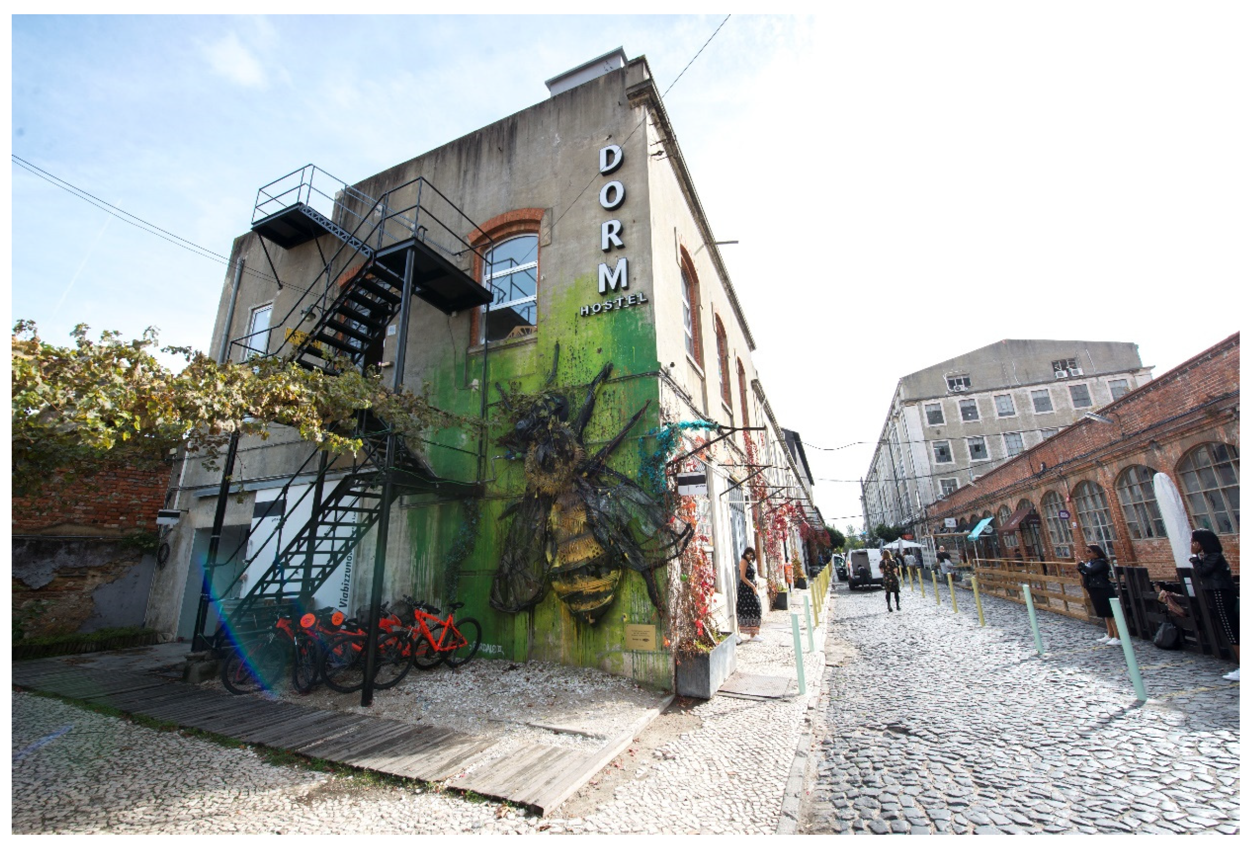
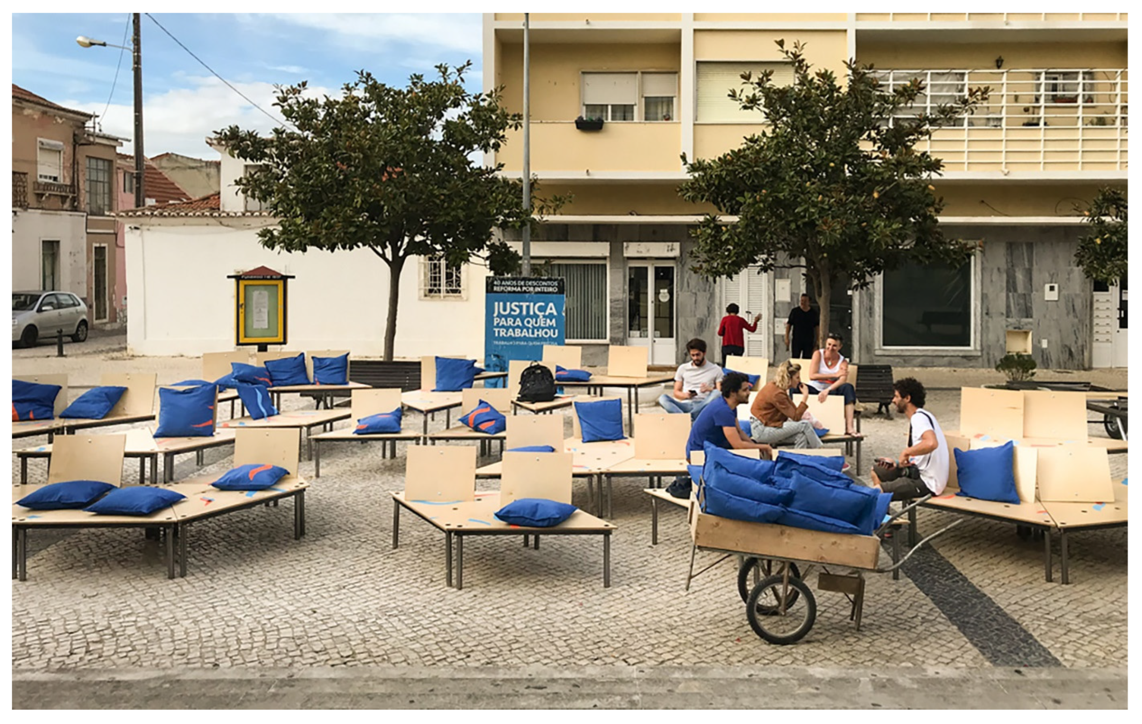
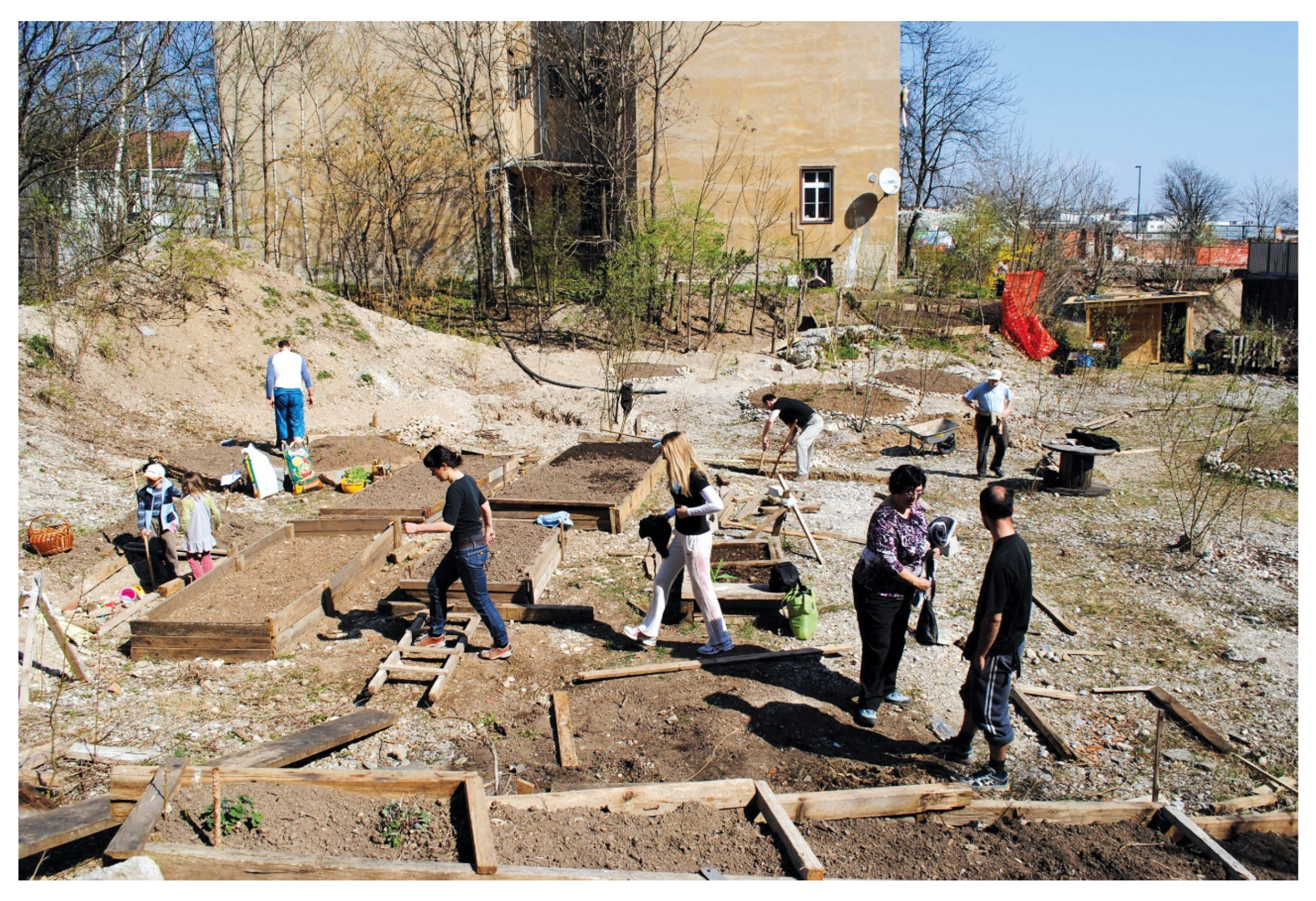
(a)
appropriate,
(b)
less appropriate,
(c)
is not appropriate.
Table 3. Comparative overview of three case studies according to four analytical dimensions.
Dimension/LocationLX Factory
(Lisbon, Portugal)
(see Figure 6)
Prisão Paraíso
(Trafaria, Portugal)
(see Figure 7)
Beyond a Construction Site
(Ljubljana, Slovenia)
(see Figure 8)
Previous use (history) of the degraded areaIndustrial area (textile, food, printing) until the 1990s.
Located in the neighbourhood of Alcântara.
Military prison until 1981, later abandoned. Located in Setubal (municipality of Almada).Abandoned construction site after investor insolvency. Located in Ljubljana central area.
Temporary use of the areaSite repurposed by a private investor for creative industries, cultural production and leisure spaces. Industrial heritage was used as economic and aesthetic leverage, with limited community involvement.Cultural and social activation initiated by the municipality in collaboration with the EDA collective, focusing on art, education and community events. Temporary use helped shape the vision for future institutional functions.Initiated by a local NGO as a bottom-up community project involving residents in co-creating green spaces, urban gardens and a public program of temporary use. Strong local engagement was present on the site.
Description of redevelopment process in the degraded areaTop-down approach is noticeable. Private owners are focused on monetization and market-driven uses. Temporary use served as a transitional phase with minimal social integration and deprivation of or participatory elements for marginal stakeholders in the process.Predominantly bottom-up approach with minor presence of top-down components. The temporary activities that were set up before redevelopment represented the basic structure of activities in the post-redevelopment period and helped set the future plans for the area through collaboration with institutional stakeholders and civil society.Predominantly top-down approach with minor bottom-up components. Temporary use ended with the redevelopment of the area into social housing. Despite strong local engagement during the temporary use phase, this participatory potential was not preserved after the end of the project.
Inclusion of socio-ecological
indicators in the process of
redevelopment of the area
Mainly physical indicators (e.g., safety, accessibility) were applied in the redevelopment process. Socio-environmental aspects were secondary. Social networks were not preserved during or supported after the redevelopment, and the community had/has limited influence on redevelopment and new activities on site.Both socio-environmental and physical–environmental indicators were used in the redevelopment process. This balanced approach allowed synergies between the owners (municipality), temporary users and local community. Cooperation between stakeholders helped select permanent sustainable uses and contents for the area.Socio-environmental indicators were used in the pre-redevelopment period to spark local community engagement and uses. This potential was abolished during the redevelopment where prevalently physical–environmental indicators were used in the process by the owners (municipality). After redevelopment, residual elements of social knowledge and networks were partially transferred to other local initiatives in the city (e.g., Creative Laboratory, Krater).
Disclaimer/Publisher’s Note: The statements, opinions and data contained in all publications are solely those of the individual author(s) and contributor(s) and not of MDPI and/or the editor(s). MDPI and/or the editor(s) disclaim responsibility for any injury to people or property resulting from any ideas, methods, instructions or products referred to in the content.

