

Flood Analysis in Lower Filyos Basin Using HEC-RAS and HEC-HMS Software

Abstract
1. Introduction
2. Materials and Methods
2.1. Description of the Study Area
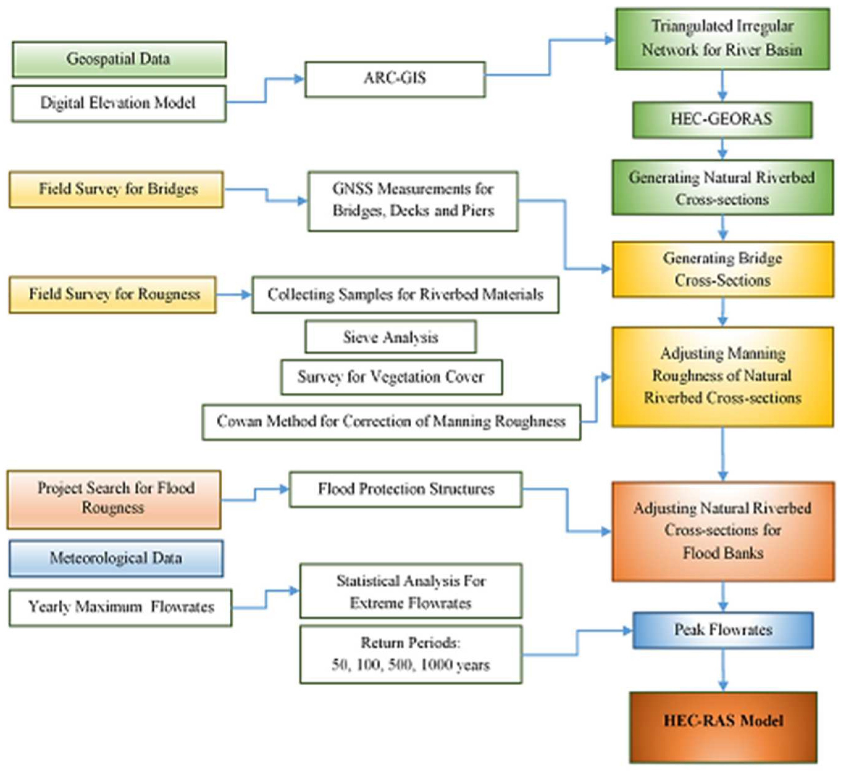
2.2. Method
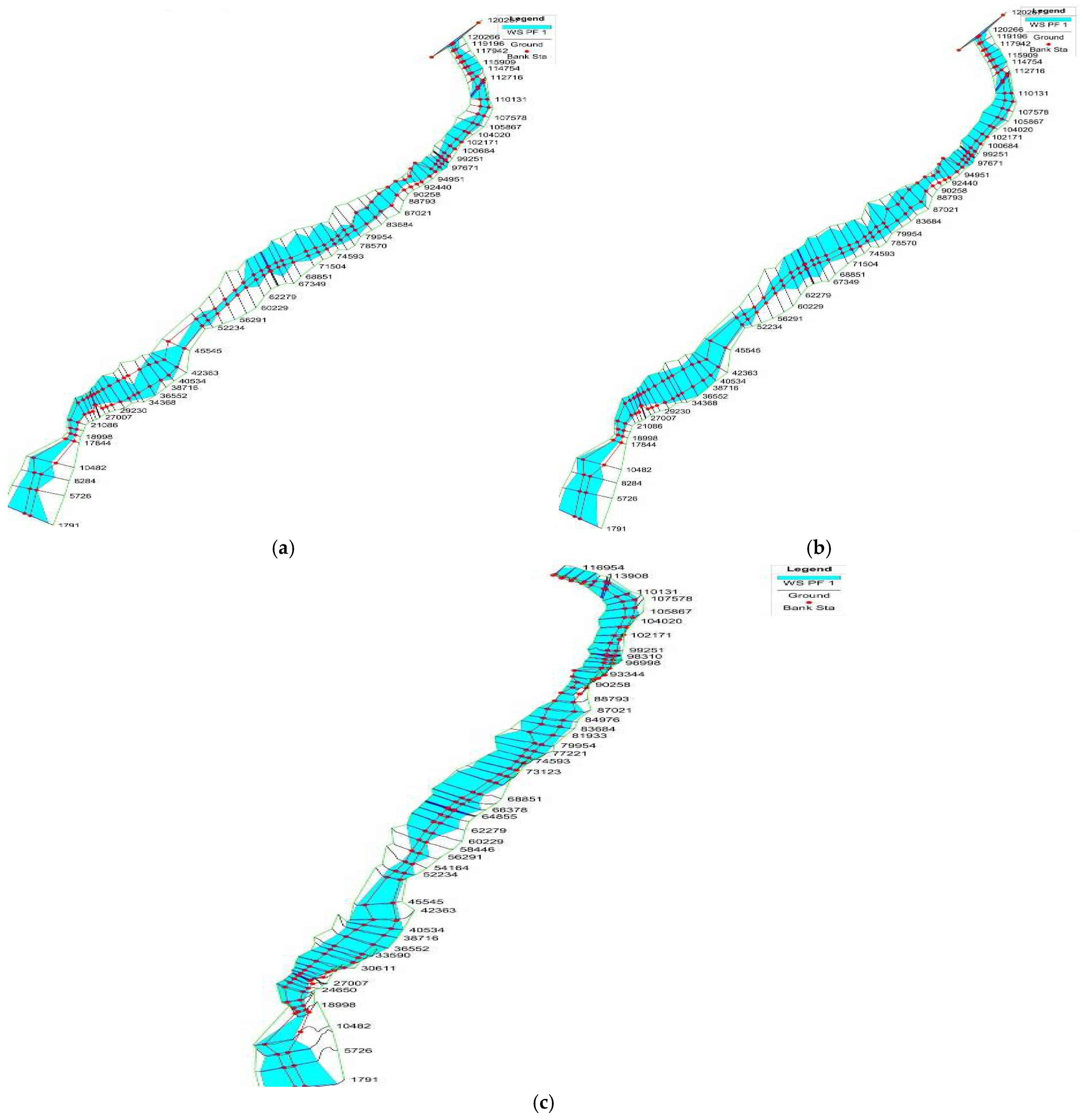
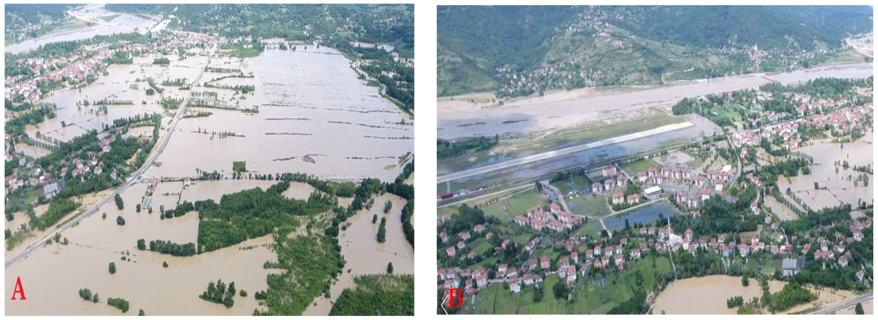
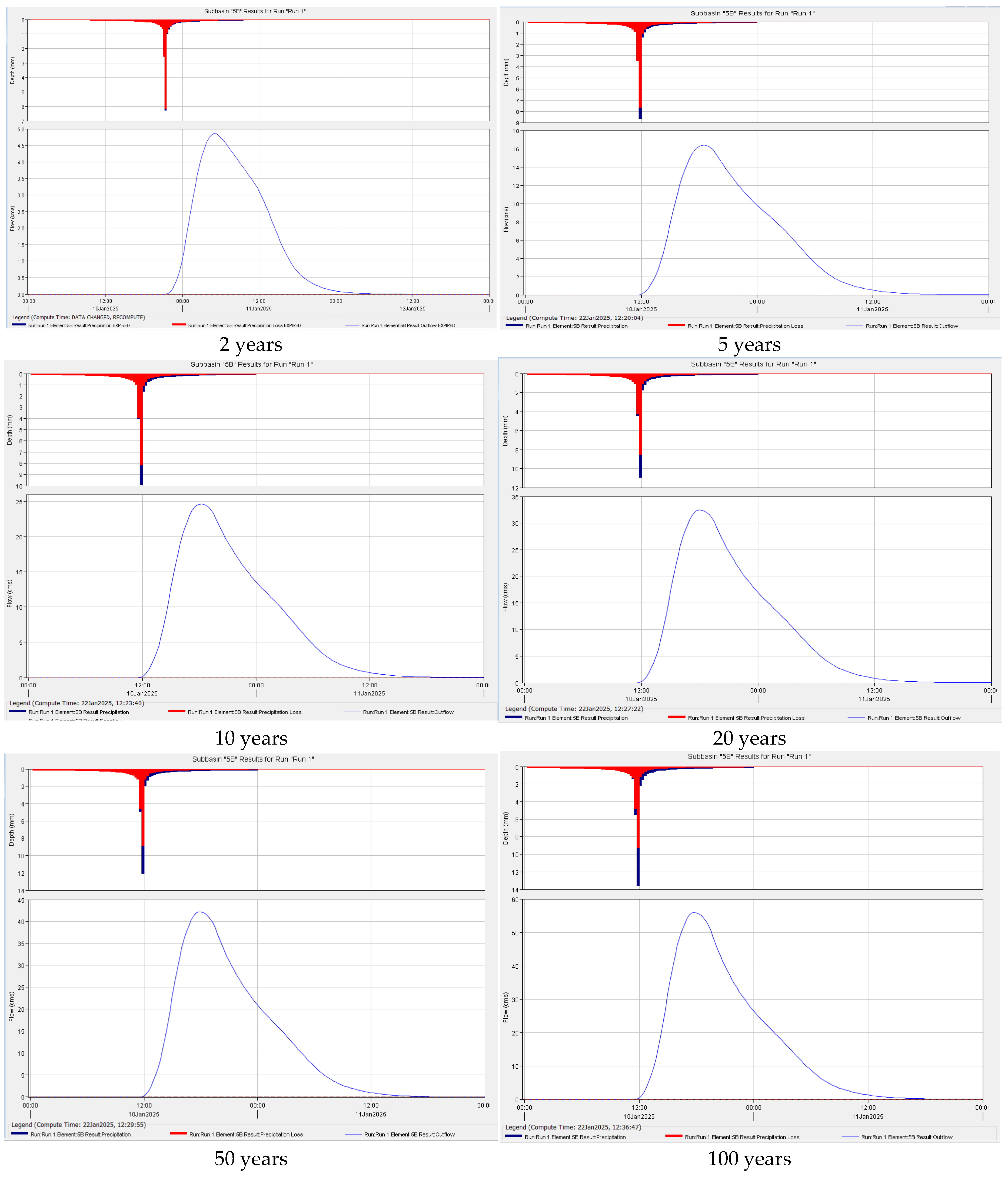
3. Results and Discussion

| Time (min) | 10 | 20 | 30 | 60 | 120 | 180 | 360 | 720 | 1440 |
|---|---|---|---|---|---|---|---|---|---|
| Bell Average | 0.2 | 0.279 | 0.343 | 0.435 | 0.565 | 0.626 | 0.75 | 0.877 | 1 |
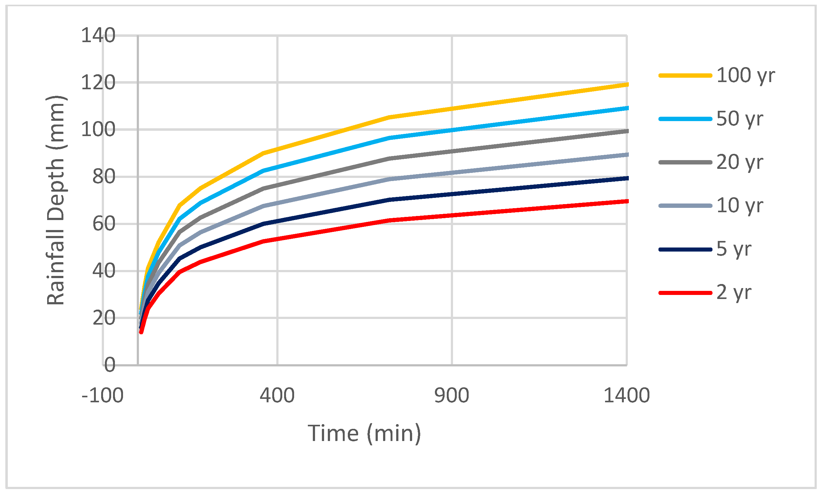
| Return Period | Time (Min) | ||||||||
|---|---|---|---|---|---|---|---|---|---|
| 10 | 20 | 30 | 60 | 120 | 180 | 360 | 720 | 1440 | |
| 2 yr | 14.0 | 19.5 | 24.0 | 30.5 | 39.6 | 43.83 | 52.5 | 61.4 | 70.1 |
| 5 yr | 16.0 | 22.3 | 27.4 | 34.8 | 45.2 | 50.07 | 60.0 | 70.2 | 79.9 |
| 10 yr | 18.0 | 25.1 | 30.9 | 39.2 | 50.9 | 56.34 | 67.5 | 79.0 | 90.0 |
| 20 yr | 20.0 | 27.9 | 34.3 | 43.5 | 56.5 | 62.61 | 75.0 | 87.7 | 100.1 |
| 50 yr | 22.0 | 30.7 | 37.7 | 47.9 | 62.2 | 68.85 | 82.5 | 96.5 | 109.9 |
| 100 yr | 24.0 | 33.5 | 41.2 | 52.2 | 67.8 | 75.12 | 90.0 | 105.2 | 120.0 |
4. Conclusions
- Development of flood early warning systems: An early warning network with automatic sensors and meteorological monitoring systems should be established in the Filyos River basin, which has a high risk of flash flooding. Thus, the risk of flooding in sudden precipitation can be detected in advance, and rapid intervention can be provided.
- Strengthen drainage and infrastructure systems: Existing stormwater drainage systems should be expanded and permeable surfaces increased. In addition, flood channels in urbanized areas should be strengthened to protect the natural flow paths of water.
- Protecting natural floodplains and reviewing land use planning: Narrowing the river bed is one of the main factors that increases the flood impact. In areas with high flood risk, green areas should be increased, and construction should be limited.
- Update hydraulic modeling studies: Changes in precipitation regime caused by climate change affect flood dynamics. Existing flood forecasting models should be revised at regular intervals, supported by up-to-date data.
- Preparation of basin-based flood management plans: DSİ, municipalities, and other relevant institutions should develop a common flood management strategy and create region-specific action plans. In this context, measures should be taken for the renewal of flood evacuation infrastructure and water diversion in high-risk areas.
- Organization of community awareness activities and disaster preparedness training programs: Information on what to do during and after floods should be provided to people living in flood-prone areas. Disaster awareness should be increased through training programs organized by schools, local administrations, and non-governmental organizations.
Funding
Institutional Review Board Statement
Informed Consent Statement
Data Availability Statement
Conflicts of Interest
References
- Venegas-Cordero, N.; Kundzewicz, Z.W.; Jamro, S.; Piniewski, M. Detection of trends in observed river floods in Poland. J. Hydrol. Reg. Stud. 2022, 41, 101098. [Google Scholar] [CrossRef]
- Cui, P.; Peng, J.; Shi, P.; Tang, H.; Ouyang, C.; Zou, Q.; Liu, L.; Li, C.; Lei, Y. Scientific Challenges of Research on Natural Hazards and Disaster Risk. Geogr. Sustain. 2021, 2, 216–223. [Google Scholar] [CrossRef]
- Das, S.; Pardeshi, S.D. Comparative Analysis of Lineaments Extracted from Cartosat, SRTM and ASTER DEM: A Study Based on Four Watersheds in Konkan Region, India. Spat. Inf. Res. 2018, 26, 47–57. [Google Scholar] [CrossRef]
- Ahmad, D.; Afzal, M. Flood Hazards and Livelihood Vulnerability of Flood-Prone Farm-Dependent Bait Households in Punjab, Pakistan. Environ. Sci. Pollut. Res. 2022, 29, 11553–11573. [Google Scholar] [CrossRef]
- Jones, E.R.; Bierkens, M.F.P.; Wanders, N.; Sutanudjaja, E.H.; Van Beek, L.P.H.; Van Vliet, M.T.H. DynQual v1.0: A high-resolution global surface water quality model. Geosci. Model Dev. 2023, 16, 4481–4500. [Google Scholar] [CrossRef]
- Ertan, A.; Özelkan, E.; Karaman, M. Determination of Flood Areas in Geographic Information Systems Platform Using Analytical Hierarchy Process: A Case Study in Çanakkale—Karamenderes Basin. J. Res. Atmos. Sci. 2021, 3, 1–9. [Google Scholar] [CrossRef]
- Ministry of Environment, Urbanization and Climate Change. Available online: https://csb.gov.tr/en (accessed on 23 May 2025).
- Mosavi, A.; Öztürk, P.; Chau, K. Flood Prediction Using Machine Learning Models: Literature Review. Water 2018, 10, 1536. [Google Scholar] [CrossRef]
- Tehrany, M.S.; Lee, M.J.; Pradhan, B.; Jebur, M.N.; Lee, S. Flood Susceptibility Mapping Using Integrated Bivariate and Multivariate Statistical Models. Environ. Earth Sci. 2014, 72, 4001–4015. [Google Scholar] [CrossRef]
- Turkish Court of Accounts. Available online: https://www.sayistay.gov.tr/?lang=en (accessed on 23 May 2025).
- Kazezyılmaz-Alhan, C.M.; Yalçın; Javanshour, K.; Aytekin, M.; Gülbaz, S. A Hydrological Model for Ayamama Watershed in Istanbul, Turkey, Using HEC-HMS. Water Pract. Technol. 2021, 16, 154–161. [Google Scholar] [CrossRef]
- Tsakiris, G. Flood Risk Assessment: Concepts, Modelling, Applications. Nat. Hazards Earth Syst. Sci. 2014, 14, 1361–1369. [Google Scholar] [CrossRef]
- Abdessamed, D.; Abderrazak, B. Coupling HEC-RAS and HEC-HMS in Rainfall–Runoff Modeling and Evaluating Floodplain Inundation Maps in Arid Environments: Case Study of Ain Sefra City, Ksour Mountain. SW of Algeria. Environ. Earth Sci. 2019, 78, 586. [Google Scholar] [CrossRef]
- Wang, X.; Liu, C. Flash Floods: Forecasting, Monitoring and Mitigation Strategies. Water 2023, 15, 1700. [Google Scholar] [CrossRef]
- Beden, N.; Ulke Keskin, A. Estimation of the Local Financial Costs of Flood Damage with Different Methodologies in Unye (Ordu), Turkey. Nat. Hazards 2021, 108, 2835–2854. [Google Scholar] [CrossRef]
- Jayanti, M.; Hadihardadja, I.K.; Dwi Ariesyady, H.; Messakh, J.J. Climate change impacts on hydrology regime and water resources sustainability in cimanuk watershed, West Java, Indonesia. Int. J. Geomate 2020, 19, 90–97. [Google Scholar] [CrossRef]
- Samarasinghe, J.T.; Makumbura, R.K.; Wickramarachchi, C.; Sirisena, J.; Gunathilake, M.B.; Muttil, N.; Teo, F.Y.; Rathnayake, U. The Assessment of Climate Change Impacts and Land-use Changes on Flood Characteristics: The Case Study of the Kelani River Basin, Sri Lanka. Hydrology 2022, 9, 177. [Google Scholar] [CrossRef]
- Iliadis, C.; Galiatsatou, P.; Glenis, V.; Prinos, P.; Kilsby, C. Urban Flood Modelling under Extreme Rainfall Conditions for Building-Level Flood Exposure Analysis. Hydrology 2023, 10, 172. [Google Scholar] [CrossRef]
- Huo, L.; Sha, J.; Wang, B.; Li, G.; Ma, Q.; Ding, Y. Revelation and Projection of Historic and Future Precipitation Characteristics in the Haihe River Basin, China. Water 2023, 15, 3245. [Google Scholar] [CrossRef]
- Dhanapala, L.; Gunarathna, M.H.J.P.; Kumari, M.K.N.; Ranagalage, M.; Sakai, K.; Meegastenna, T.J. Towards Coupling of 1D and 2D Models for Flood Simulation—A Case Study of Nilwala River Basin, Sri Lanka. Hydrology 2022, 9, 17. [Google Scholar] [CrossRef]
- Azhar, H.; Mohammed, S.; Mohammed, L.A. Simulation of Floods in Delhi Segment of River Yamuna Using HEC-RAS. Am. J. Water Resour. 2018, 6, 162–168. [Google Scholar]
- Hamdan, A.N.A.; Almuktar, S.; Scholz, M. Rainfall-Runoff Modeling Using the HEC-HMS Model for the Al-Adhaim River Catchment, Northern Iraq. Hydrology 2021, 8, 58. [Google Scholar] [CrossRef]
- Ameera, M.A. Hydraulic Model Development using HEC-RAS and Determination of Manning Roughness Value for Shatt Al-Rumaith. Muthanna. J. Eng. Technol. 2016, 4, 9–13. [Google Scholar]
- Feldmann, D.; Laux, P.; Heckl, A.; Schindler, M.; Kunstmann, H. Determining near surface roughness based on artificial precipitation experiments on natural hillslopes for the application in hydrodynamic flash flood modelling. In Proceedings of the 2, EGU General Assembly, Vienna, Austria, 23–28 April 2023. [Google Scholar] [CrossRef]
- Dawood, A.H.; Mawlood, D.K.; Al-Ansari, N. Flood Modeling on Koya Catchment Area Using Hyfran, Web Map Service, and HEC-RAS Software. Aro-Sci. J. Koya Univ. 2021, 9, 107–111. [Google Scholar] [CrossRef]
- Abubakr, T. Evaluation of The Best Fit Distribution for Maximum Daily Rainfall Series in Wadi Arbaat, Eastern Sudan. In Proceedings of the International Conference on Water, Energy and Environment (ICWEE/7), Sharjah, United Arab Emirates, 22–24 November 2022; Volume 7. [Google Scholar]
- El Adlouni, S.; Bobée, B. Hydrological Frequency Analysis Using HYFRAN-PLUS Software. User’s Guide Available with the Software DEMO. 2015. Available online: http://www.wrpllc.com/books/HyfranPlus/indexhyfranplus3.html (accessed on 1 October 2024).
- Verma, A.K.; Jha, M.K.; Mahana, R.K. Evaluation of HEC-HMS and WEPP for simulating watershed runoff using remote sensing and geographical information system. Paddy Water Environ. 2010, 8, 131–144. [Google Scholar] [CrossRef]
- Khan, Z.; Alim, M.A.; Rahman, M.M.; Rahman, A. A continental scale evaluation of rainwater harvestingin Australia. Resour. Conserve Recycl. 2021, 167, 105378. [Google Scholar] [CrossRef]
- Mesta, B.; Kargı, P.G.; Tezyapar, İ.; Ayvaz, M.T.; Göktas, R.K.; Kentel, E.; Tezel, U. Determination of rainfall-runoff relationship in Yenicegoruce Basin with HEC-HMS hydrologic model. Pamukkale Univ. J. Eng. Sci. 2019, 25, 949–955. [Google Scholar] [CrossRef]
- Gül, G.O.; Harmancıoğlu, N.; Gül, A. A Combined Hydrologic and Hydraulic Modeling Approach for Testing Efficiency of Structural Flood Control Measures. Nat. Hazards 2010, 54, 245–260. [Google Scholar] [CrossRef]
- Hashemyan, F.; Khaleghi, M.; Kamyar, M. Combination of HEC-HMS and HEC-RAS Models in GIS in Order to Simulate Flood (Case Study: Khoshke Rudan River in Fars Province, Iran). Res. J. Recent Sci. 2015, 4, 122–127. Available online: https://www.isca.in (accessed on 20 April 2025).
- Yamani, K.; Hazzab, A.; Sekkoum, M.; Slimane, T. Mapping of Vulnerability of Flooded Area in Arid Region. Case Study: Area of Ghardaïa-Algeria. Model. Earth Syst. Environ. 2016, 2, 147. [Google Scholar] [CrossRef]
- Namara, W.G.; Damisse, T.A.; Tufa, F.G. Application of HEC-RAS and HEC-GeoRAS Model for Flood Inundation Mapping, the Case of Awash Bello Flood Plain, Upper Awash River Basin, Oromiya Regional State, Ethiopia. Model. Earth Syst. Environ. 2022, 8, 1449–1460. [Google Scholar] [CrossRef]
- Sañudo, E.; Cea, L.; Puertas, J. Modelling pluvial flooding in urban areas coupling the models iber and SWMM. Water 2020, 12, 2647. [Google Scholar] [CrossRef]
- Sanz-Ramos, M.; Bladé, E.; González-Escalona, F.; Olivares, G.; Aragón-Hernández, J.L. Interpreting the manning roughness coefficient in overland flow simulations with coupled hydrological-hydraulic distributed models. Water 2021, 13, 3433. [Google Scholar] [CrossRef]
- Aksoy, B.; Öztürk, M.; Özölçer, İ.H. Effect of Bed Material on Roughness and Hydraulic Potential in Filyos River. Water 2024, 16, 2934. [Google Scholar] [CrossRef]
- Anand, J.; Gosain, A.K.; Khosa, R. Hydrological and hydrodynamic modelling for flood management: A case study of the Yamuna River Basin in Delhi. J. Hydrol. Reg. Stud. 2024, 56, 101960. [Google Scholar] [CrossRef]
- Hicks, F.E. Hydraulic Flood Routing with Minimal Channel Data: Peace River, Canada. Can. J. Civ. Eng. 1996, 23, 524–535. [Google Scholar] [CrossRef]
- Slim, M. Frequency analysis of extreme rainfall over the Japanese archipelago by leveraging gauge-adjusted radar and satellite estimates. J. Hydrol. 2024, 637, 131425. [Google Scholar] [CrossRef]
- Moriasi, D.N.; Wilson, B.N.; Douglas-Mankin, K.R.; Arnold, J.G.; Gowda, P.H. Hydrologic And Water Quality Models: Use, Calibration, And Validation. Trans. ASABE 2012, 55, 1241–1247. [Google Scholar] [CrossRef]
- Santhi, C.; Arnold, J.G.; Williams, J.R.; Dugas, W.A.; Srinivasan, R.; Hauck, L.M. Validation Of The Swat Model On A Large Rwer Basin With Point And Nonpoint Sources. J. Am. Water Resour. Assoc. 2007, 37, 1169–1188. [Google Scholar] [CrossRef]
- Van Liew, M.W.; Arnold, J.G.; Garbrecht, J.D. Hydrologic Simulation On Agricultural Watersheds: Choosing Between Two Models. Am. Soc. Agric. Biol. Eng. St. Joseph 2003, 46, 1539–1551. [Google Scholar] [CrossRef]


| Year | Max. Annual Rainfall (mm) | Year | Max. Annual Rainfall (mm) | Year | Max. Annual Rainfall (mm) | Year | Max. Annual Rainfall (mm) |
|---|---|---|---|---|---|---|---|
| 1940 | 69.70 | 1961 | 73.60 | 1982 | 103.40 | 2003 | 47.60 |
| 1941 | 35.50 | 1962 | 62.70 | 1983 | 113.40 | 2004 | 78.60 |
| 1942 | 75.50 | 1963 | 66.70 | 1984 | 89.50 | 2005 | 56.00 |
| 1943 | 124.50 | 1964 | 106.60 | 1985 | 78.10 | 2006 | 70.60 |
| 1944 | 48.60 | 1965 | 73.90 | 1986 | 37.40 | 2007 | 114.40 |
| 1945 | 95.10 | 1966 | 92.00 | 1987 | 48.50 | 2008 | 72.50 |
| 1946 | 46.80 | 1967 | 83.80 | 1988 | 60.90 | 2009 | 89.60 |
| 1947 | 81.10 | 1968 | 46.90 | 1989 | 144.20 | 2010 | 66.40 |
| 1948 | 56.90 | 1969 | 37.30 | 1990 | 67.40 | 2011 | 39.60 |
| 1949 | 39.90 | 1970 | 128.80 | 1991 | 78.60 | 2012 | 55.40 |
| 1950 | 54.00 | 1971 | 65.60 | 1992 | 90.50 | 2013 | 81.60 |
| 1951 | 86.20 | 1972 | 153.70 | 1993 | 61.30 | 2014 | 61.90 |
| 1952 | 56.30 | 1973 | 72.50 | 1994 | 95.30 | 2015 | 68.20 |
| 1953 | 79.90 | 1974 | 78.60 | 1995 | 56.60 | 2016 | 89.00 |
| 1954 | 147.10 | 1975 | 85.10 | 1996 | 57.40 | 2017 | 109.70 |
| 1955 | 431.50 | 1976 | 74.00 | 1997 | 107.00 | 2018 | 43.20 |
| 1956 | 63.90 | 1977 | 37.30 | 1998 | 91.80 | 2019 | 99.40 |
| 1957 | 74.20 | 1978 | 63.10 | 1999 | 56.80 | 2020 | 69.00 |
| 1958 | 61.20 | 1979 | 100.50 | 2000 | 100.40 | 2021 | 55.30 |
| 1959 | 59.20 | 1980 | 48.70 | 2001 | 78.20 | 2022 | 94.10 |
| 1960 | 127.40 | 1981 | 147.90 | 2002 | 62.00 | 2023 | 110.80 |
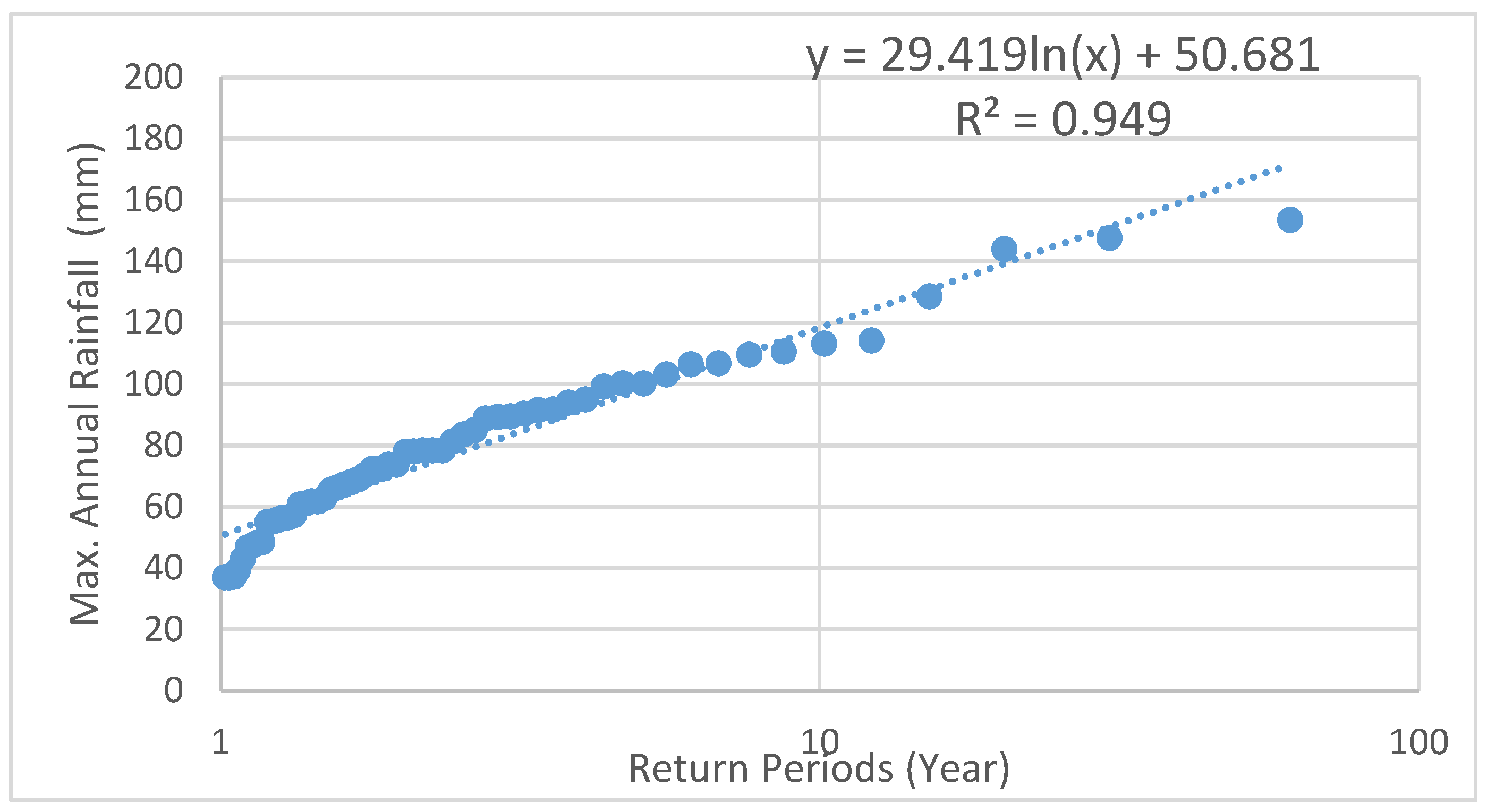
| Statistical Distribution | Design Precipitation Depth for Different Return Periods | |||||
|---|---|---|---|---|---|---|
| Years | ||||||
| 2 | 5 | 10 | 20 | 50 | 100 | |
| Normal | 71.7 | 109 | 134.8 | 159.3 | 190.4 | 213.2 |
| Number of Years | 84 |
|---|---|
| Minimum Value | 35.5 |
| Maximum Value | 431.5 |
| Average Value | 81.73 |
| Standard Deviation | 47.23 |
| Median | 73.75 |
| Coefficient of Variation (Cv) | 0.58 |
| Skewness Coefficient (Cs) | 5.08 |
| Kurtosis Coefficient (Ck) | 8.27 |
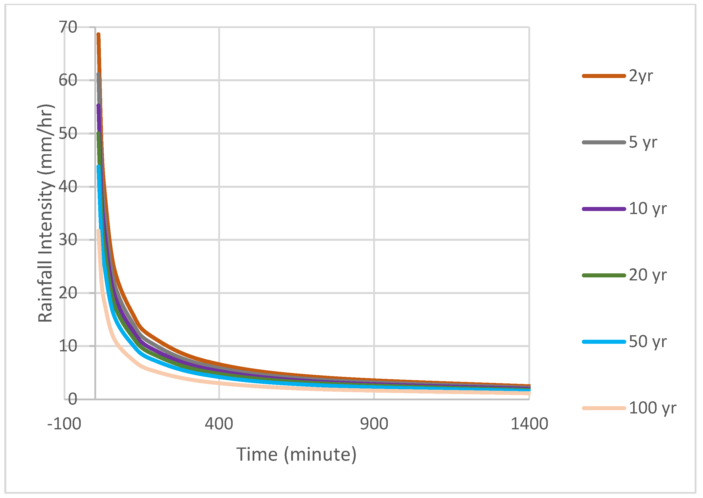
| Return Periods (Years) | Time (Min) | ||||||||
|---|---|---|---|---|---|---|---|---|---|
| 10 | 20 | 30 | 60 | 120 | 180 | 360 | 720 | 1440 | |
| 100 | 144.00 | 100.44 | 82.32 | 52.20 | 33.90 | 25.04 | 15.00 | 8.77 | 5.00 |
| 50 | 132.00 | 92.07 | 75.46 | 47.85 | 31.08 | 22.95 | 13.75 | 8.04 | 4.58 |
| 20 | 120.00 | 83.70 | 68.60 | 43.50 | 28.25 | 20.87 | 12.50 | 7.31 | 4.17 |
| 10 | 108.00 | 75.33 | 61.74 | 39.15 | 25.43 | 18.78 | 11.25 | 6.58 | 3.75 |
| 5 | 96.00 | 66.96 | 54.88 | 34.80 | 22.60 | 16.69 | 10.00 | 5.85 | 3.33 |
| 2 | 84.00 | 58.59 | 48.02 | 30.45 | 19.78 | 14.61 | 8.75 | 5.12 | 2.92 |
| Lag Time (h) | Concentration Time (h) | Curve Number | Hydrologic Soil Groups |
|---|---|---|---|
| 0.1 | 0.12 | 80 | B: Sandy soil with moderate infiltration |
| C: Clay soil with slow infiltration |
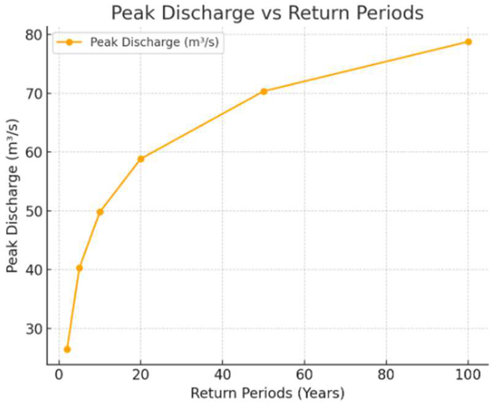
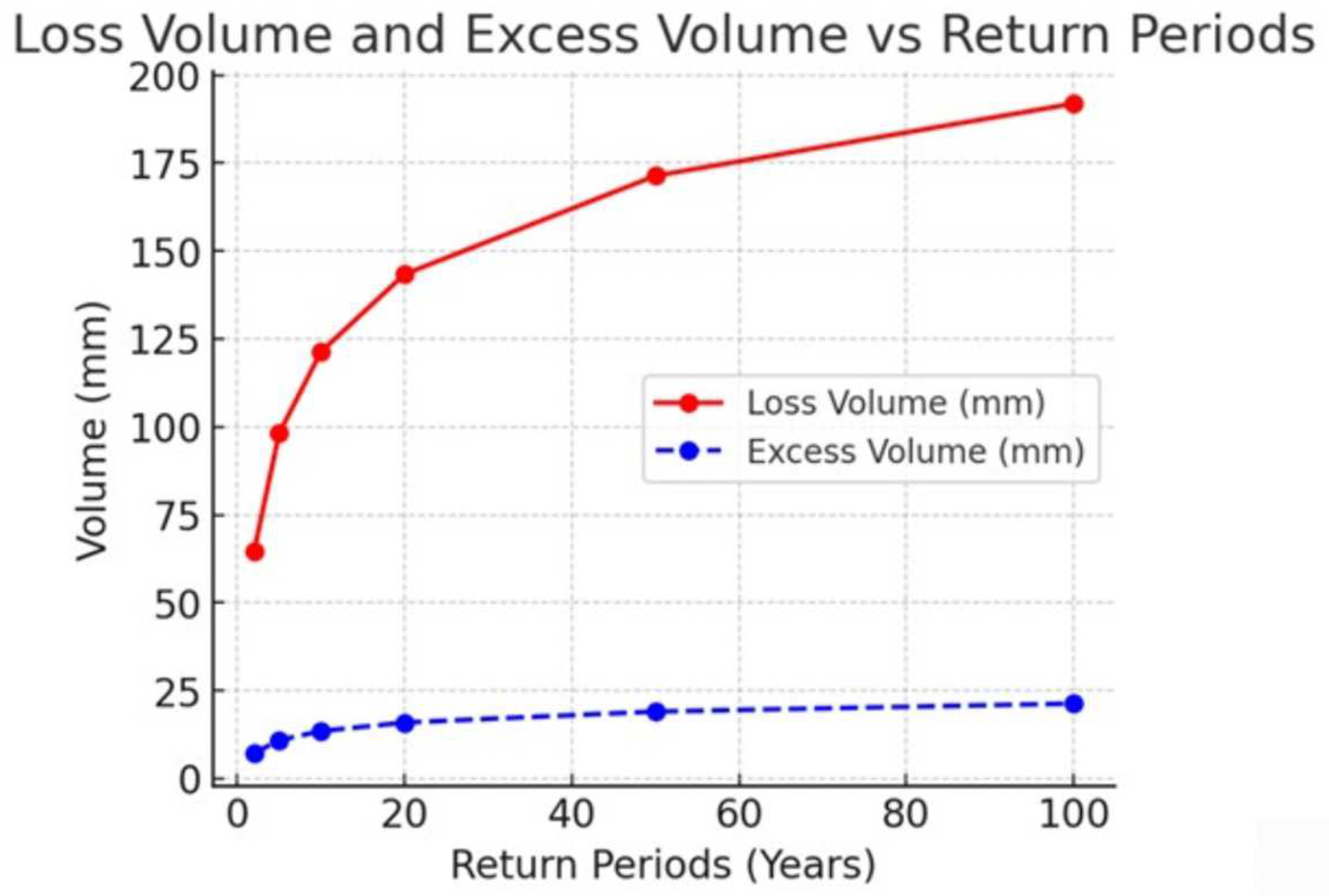
| Periods (Years) | Precipitation Volume (mm) | Loss Volume (mm) | Excess Volume (mm) | Discharge Volume (1000 m3) | Peak Discharge (m3/s) |
|---|---|---|---|---|---|
| 2 | 71.70 | 64.53 | 7.17 | 95.36 | 26.49 |
| 5 | 109.00 | 98.10 | 10.90 | 144.97 | 40.27 |
| 10 | 134.80 | 121.32 | 13.48 | 179.28 | 49.80 |
| 20 | 159.30 | 143.37 | 15.93 | 211.87 | 58.85 |
| 50 | 190.40 | 171.36 | 19.04 | 253.23 | 70.34 |
| 100 | 213.20 | 191.88 | 21.32 | 283.56 | 78.77 |
Disclaimer/Publisher’s Note: The statements, opinions and data contained in all publications are solely those of the individual author(s) and contributor(s) and not of MDPI and/or the editor(s). MDPI and/or the editor(s) disclaim responsibility for any injury to people or property resulting from any ideas, methods, instructions or products referred to in the content. |
© 2025 by the author. Licensee MDPI, Basel, Switzerland. This article is an open access article distributed under the terms and conditions of the Creative Commons Attribution (CC BY) license (https://creativecommons.org/licenses/by/4.0/).
Share and Cite
Aksoy, B. Flood Analysis in Lower Filyos Basin Using HEC-RAS and HEC-HMS Software. Sustainability 2025, 17, 5220. https://doi.org/10.3390/su17115220
Aksoy B. Flood Analysis in Lower Filyos Basin Using HEC-RAS and HEC-HMS Software. Sustainability. 2025; 17(11):5220. https://doi.org/10.3390/su17115220
Chicago/Turabian StyleAksoy, Berna. 2025. "Flood Analysis in Lower Filyos Basin Using HEC-RAS and HEC-HMS Software" Sustainability 17, no. 11: 5220. https://doi.org/10.3390/su17115220
APA StyleAksoy, B. (2025). Flood Analysis in Lower Filyos Basin Using HEC-RAS and HEC-HMS Software. Sustainability, 17(11), 5220. https://doi.org/10.3390/su17115220