
Mapping Soil Erosion Potential in Algeria’s Wadi Mina Basin: Insights from Revised Universal Soil Loss Equation and Geographic Information System for Sustainable Land Management

 ,
,  , ,
, ,  , and
, and 
Abstract
1. Introduction
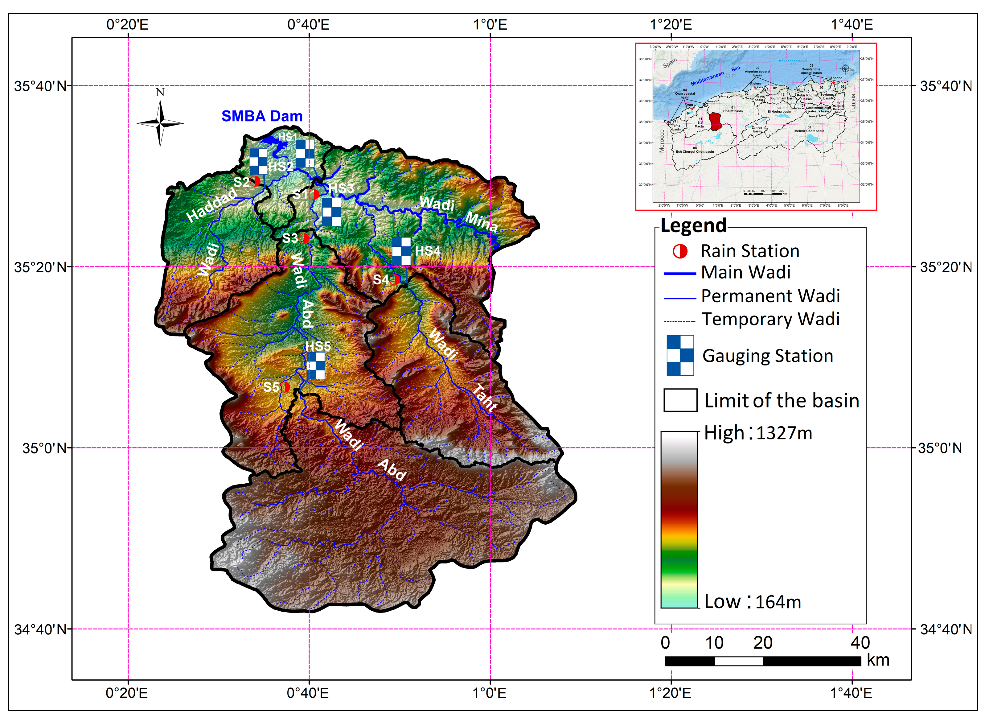
2. Study Area and Data
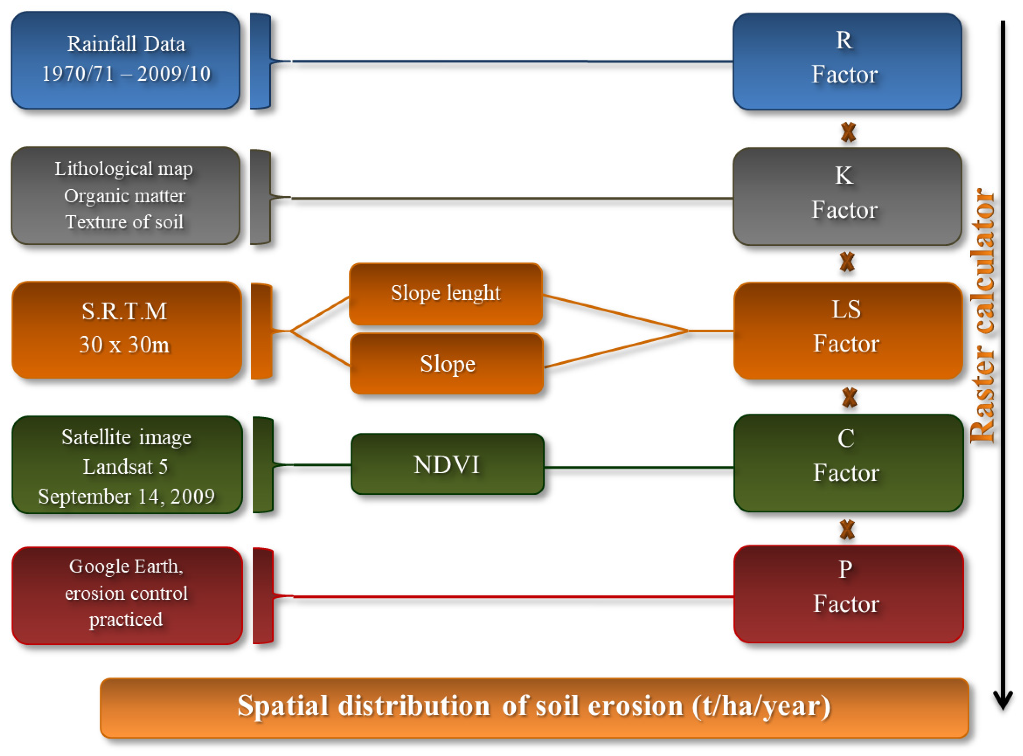
3. Materials and Methods
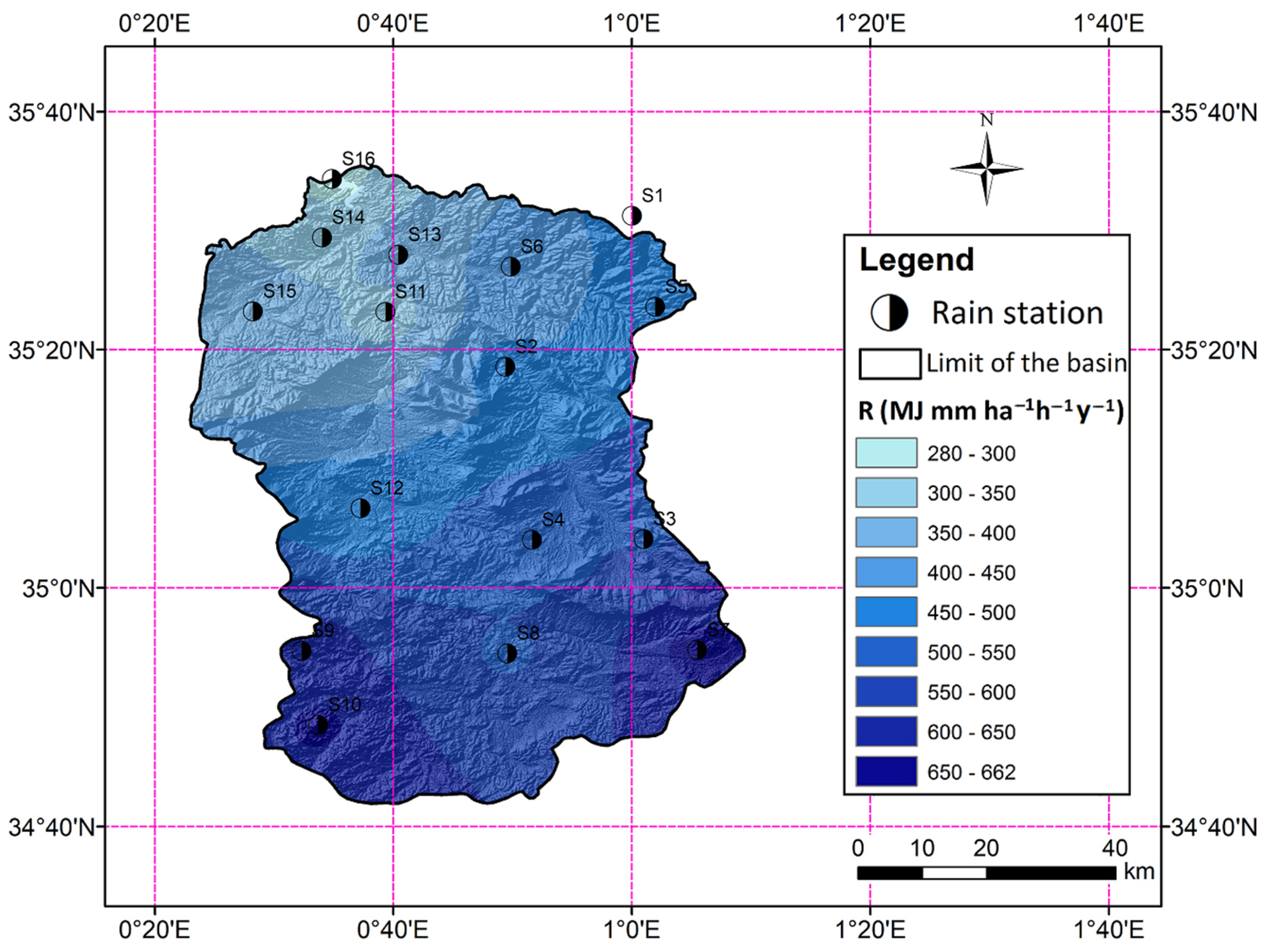
3.1. Rainfall Erosivity Factor (R)
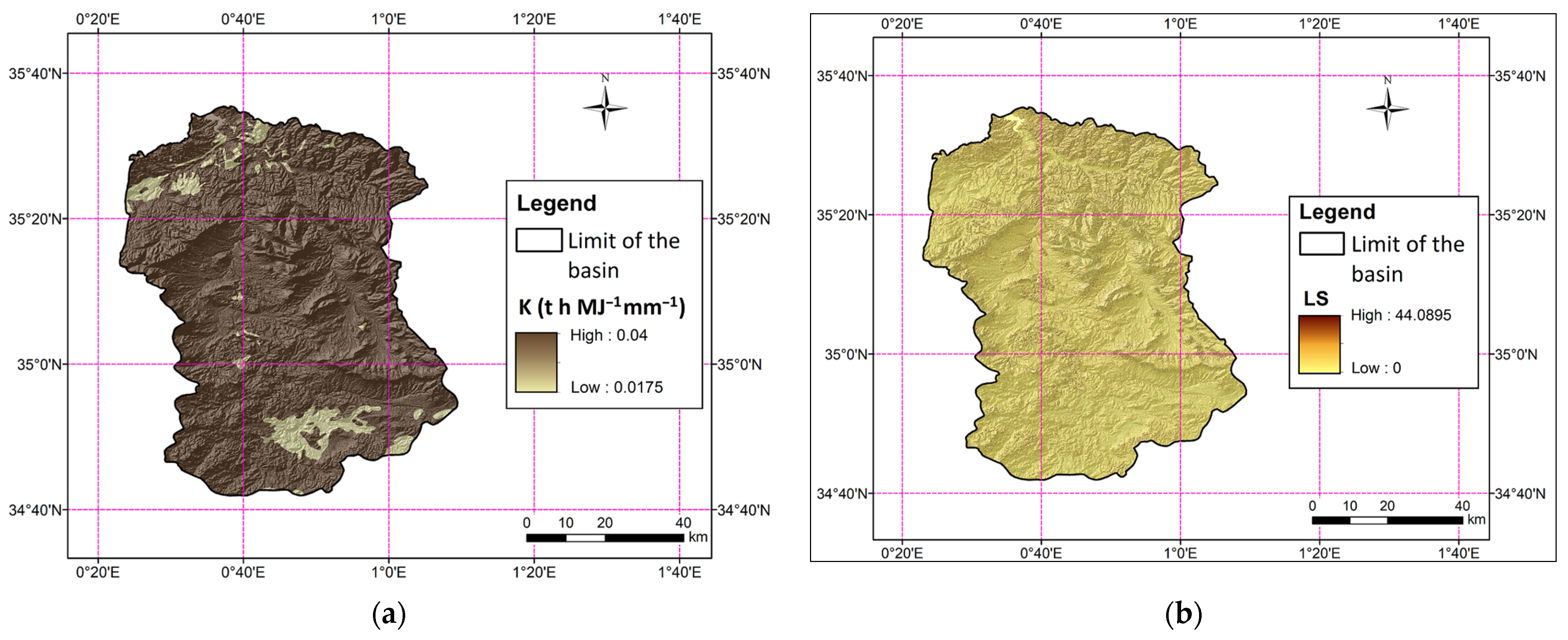
3.2. Soil Erodibility Factor (K)
3.3. Topographic Factor (LS)
3.4. Cover Management Factor (C)
3.5. Conservation Support Practice Factor (P)
3.6. Factor of Erosion (A)
4. Results and Interpretation
5. Conclusions and Recommendations
Author Contributions
Funding
Institutional Review Board Statement
Informed Consent Statement
Data Availability Statement
Acknowledgments
Conflicts of Interest
Abbreviations
| RUSLE | Revised Universal Soil Loss Equation |
| R | erosive capacity of rainfall |
| K | susceptibility of soil to erosion |
| Ls | length and gradient of slopes |
| C | characteristics of cover management |
| P | conservation measures |
| SDR | Sediment Delivery Ratio |
| DEM | Digital Elevation Model |
| ANRH | National Water Resources Agency |
| SRTM | Shuttle Radar Topographic Mission |
| USGS | United States Geological Survey |
| SSY | suspended sediment yield |
| SRC | sediment rating curves |
References
- Chadli, K. Estimation of soil loss using RUSLE model for Sebou watershed (Morocco). Model. Earth Syst. Environ. 2016, 2, 51. [Google Scholar] [CrossRef]
- Igwe, P.U.; Onuigbo, A.A.; Chinedu, O.C.; Ezeaku, I.I.; Muoneke, M.M. Soil erosion: A review of models and applications. Int. J. Adv. Sci. Res. 2017, 4, 138–150. [Google Scholar] [CrossRef]
- Wischmeier, W.H.; Smith, D.D. Predicting Rainfall Erosion Losses, a Guide to Conservation Planning; U.S. Department of Agriculture: Washington, DC, USA, 1978; Volume 537, p. 62. [Google Scholar]
- Renard, K.G.; Foster, G.R.; Weesies, G.A.; Porter, J.P. RUSLE: Revised universal soil loss equation. J. Soil Water Conserv. 1991, 46, 30–33. [Google Scholar] [CrossRef]
- Morgan, R.P.C.; Quinton, J.N.; Smith, R.E.; Govers, G.; Poesen, J.W.A.; Auerswald, K.; Chisci, G.; Torri, D.; Styczen, M.E. The European soil erosion model (EUROSEM): A dynamic approach for predicting sediment transport from felds and small catchments. Earth Surf. Process. Landf. 1998, 23, 527–544. [Google Scholar] [CrossRef]
- Gavrilovic, S. Engineering of Debris Flow and Erosion; Izgradnja: Belgrade, Serbia, 1972; p. 292. (In Serbian) [Google Scholar]
- De Roo, A.P.J.; Hazelhoff, L.; Burrough, P.A. Soil erosion modelling using ‘answers’ and geographical information systems. Earth Surf. Process. Landf. 1989, 14, 517–532. [Google Scholar] [CrossRef]
- Loch, R.J.; Silburn, D.M.; Freebairn, D.M. Evaluation of the CREAMS model II. Use of rainulator data to derive soil erodibility parameters and prediction of field soil losses using derived parameters. Aust. J. Soil Res. 1989, 27, 563–576. [Google Scholar] [CrossRef]
- Smith, R.E.; Goodrich, D.C.; Quinton, J.N. Dynamic, distributed simulation of watershed erosion: The KINEROS2 and EUROSEM models. J. Soil Water Conserv. 1995, 50, 517–520. [Google Scholar] [CrossRef]
- Botterweg, P.; Leek, R.; Romstad, E.; Vatn, A. The EUROSEMGRIDSEM modelling system for erosion analyses under different natural and economic conditions. Ecol. Model. 1998, 108, 115–129. [Google Scholar] [CrossRef]
- Williams, J.R.; Jones, C.A.; Dyke, P.T. A modeling approach to determining the relationship between erosion and soil productivity. Trans. ASAE 1984, 27, 129–144. [Google Scholar] [CrossRef]
- De Jong van Lier, Q.; Sparovek, G.; Flanagan, D.C.; Bloem, E.M.; Schnug, E. Runoff mapping using WEPP erosion model and GIS tools. Comput. Geosci. 2005, 31, 1270–1276. [Google Scholar] [CrossRef]
- Kirkby, M.J.; Le Bissonais, Y.; Coulthard, T.J.; Daroussin, J.; McMahon, M.D. The development of land quality indicators for soil degradation by water erosion. Agric. Ecosyst. Environ. 2000, 81, 125–135. [Google Scholar] [CrossRef]
- Srinivasan, R.; Engel, B.A. A spatial decision support system for assessing agricultural nonpoint source pollution. Water Resour. Bull. 1994, 30, 441–452. [Google Scholar] [CrossRef]
- Viney, N.R.; Sivapalan, M.; Deeley, D. A conceptual model of nutrient mobilisation and transport applicable at large catchment scales. J. Hydrol. 2000, 240, 23–44. [Google Scholar] [CrossRef]
- Arnold, J.G.; Srinivasan, R.; Muttiah, R.S.; Williams, J.R. Large area hydrologic modeling and assessment part I: Model development. J. Am. Water Resour. Assoc. 1998, 34, 73–89. [Google Scholar] [CrossRef]
- De Vente, J.; Poesen, J.; Verstraeten, G.; Govers, G.; Vanmaercke, M.; van Rompaey, A.; Arabkhedri, M.; Boix-Fayos, C. Predicting soil erosion and sediment yield at regional scales: Where do we stand? Earth-Sci. Rev. 2013, 127, 16–29. [Google Scholar] [CrossRef]
- Dutta, S. Soil erosion, sediment yield and sedimentation of reservoir: A review. Model. Earth Syst. Environ. 2016, 2, 123. [Google Scholar] [CrossRef]
- Batista, P.V.G.; Davies, J.; Silva, M.L.N.; Quinton, J.N. On the evaluation of soil erosion models: Are we doing enough? Earth-Sci. Rev. 2019, 197, 102898. [Google Scholar] [CrossRef]
- Azaiez, N. Quantification des pertes en terre dans le bassin versant de l’oued Chaâf au Sud-Ouest de l’Arabie Saoudite. Cinq Cont. 2024, 14, 74–97. [Google Scholar]
- Panagos, P.; Borrelli, P.; Meusburger, K.; Alewell, C.; Lugato, E.; Montanarella, L. Estimating the soil erosion cover-management factor at the European scale. Land Use Policy 2015, 48, 38–50. [Google Scholar] [CrossRef]
- Terranova, O.; Antronico, L.; Coscarelli, R.; Iaquinta, P. Soil erosion risk scenarios in the Mediterranean environment using RUSLE and GIS: An application model for Calabria (southern Italy). Geomorphology 2009, 112, 228–245. [Google Scholar] [CrossRef]
- Onori, F.; De Bonis, P.; Grauso, S. Soil erosion prediction at the basin scale using the revised universal soil loss equation (RUSLE) in a catchment of Sicily (southern Italy). Environ. Earth Sci. 2006, 50, 1129–1140. [Google Scholar] [CrossRef]
- Balasubramani, K.; Veena, M.; Kumaraswamy, K.; Saravanabavan, V. Estimation of soil erosion in a semi-arid watershed of Tamil Nadu (India) using revised universal soil loss equation (rusle) model through GIS. Model. Earth Syst. Environ. 2015, 1, 10. [Google Scholar] [CrossRef]
- Kefi, M.; Yoshino, K.; Setiawan, Y.; Zayani, K.; Boufaroua, M. Assessment of the effects of vegetation on soil erosion risk by water: A case of study of the Batta watershed in Tunisia. Environ. Earth Sci. 2011, 64, 707–719. [Google Scholar] [CrossRef]
- Chafai, A.; Brahim, N.; Shimi, N.S. Mapping of water erosion by GIS/RUSLE approach: Watershed Ayda river—Tunisia study. Arab. J. Geosci. 2020, 13, 810. [Google Scholar] [CrossRef]
- Brahim, B.; Meshram, S.G.; Abdallah, D.; Larbi, B.; Drisss, S.; Khalid, M.; Khedher, K.M. Mapping of soil sensitivity to water erosion by RUSLE model: Case of the Inaouene watershed (Northeast Morocco). Arab. J. Geosci. 2020, 13, 1153. [Google Scholar] [CrossRef]
- Ed-daoudy, L.; Lahmam, N.; Benmansour, M.; Afilal, H.; Ben Harra, A.; Damnati, B. Hydric erosion rates in Raouz watershed, Morocco: RUSLE, GIS, and remote sensing. RSASE 2023, 32, 101056. [Google Scholar] [CrossRef]
- Benchettouh, A.; Kouri, L.; Jebari, S. Spatial estimation of soil erosion risk using RUSLE/GIS techniques and practices conservation suggested for reducing soil erosion in Wadi Mina watershed (northwest, Algeria). Arab. J. Geosci. 2017, 10, 79. [Google Scholar] [CrossRef]
- Toubal, A.K.; Achite, M.; Ouillon, S.; Dehni, A. Soil erodibility mapping using the RUSLE model to prioritize erosion control in the Wadi Sahouat basin, North-West of Algeria. Environ. Monit. Assess. 2018, 190, 210. [Google Scholar] [CrossRef]
- Djoukbala, O.; Hasbaia, M.; Benselama, O.; Mazour, M. Comparison of the erosion prediction models from USLE, MUSLE and RUSLE in a Mediterranean watershed, case of Wadi Gazouana (NW of Algeria). Model. Earth Syst. Environ. 2019, 5, 725–743. [Google Scholar] [CrossRef]
- Chikh, H.; Habi, M.; Morsli, B. Influence of vegetation cover on the assessment of erosion and erosive potential in the Isser marly watershed in northwestern Algeria—Comparative study of RUSLE and PAP/RAC methods. Arab. J. Geosci. 2019, 12, 154. [Google Scholar] [CrossRef]
- Sahli, Y.; Mokhtari, E.; Merzouk, B.; Laignel, B.; Vial, C.; Madani, K. Mapping surface water erosion potential in the Soummam watershed in Northeast Algeria with RUSLE model. J. Mt. Sci. 2019, 16, 1606–1615. [Google Scholar] [CrossRef]
- Badreddine, B.; Mohammed, H.; Boutkhil, M.; Ahmed, A. Assessment of erosion: Use of nuclear techniques and conventional methods—Case of the Fergoug watershed, Algeria. Environ. Monit. Assess. 2021, 193, 55. [Google Scholar] [CrossRef] [PubMed]
- Bouamrane, A.; Bouamrane, A.; Abida, H. Water erosion hazard distribution under a Semi-arid climate Condition: Case of Mellah Watershed, North-eastern Algeria. Geoderma 2021, 403, 115381. [Google Scholar] [CrossRef]
- Ouadja, A.; Benfetta, H.; Porto, P.; Flanagan, D.C.; Mihoubi, M.K.; Omeir, M.R.; Graia, M.; Ghosal, K.; Talchabhadel, R. Mapping potential soil erosion using RUSLE, Remote Sensing, and GIS: A case study in the watershed of Oued El Ardjem, Northwest Algeria. Arab. J. Geosci. 2021, 14, 1945. [Google Scholar] [CrossRef]
- Boussadia-Omari, L.; Ouillon, S.; Hirche, A.; Salamani, M.; Guettouche, M.S.; Ihaddadene, L.; Nedjraoui, D. Contribution of phytoecological data to spatialize soil erosion: Application of the RUSLE model in the Algerian Atlas. ISWCR 2021, 9, 502–519. [Google Scholar] [CrossRef]
- Bensekhria, A.; Bouhata, R. Assessment and Mapping Soil Water Erosion Using RUSLE Approach and GIS Tools: Case of Oued el-Hai Watershed, Aurès West, Northeastern of Algeria. ISPRS Int. J. Geo-Inf. 2022, 11, 84. [Google Scholar] [CrossRef]
- Saoud, M.; Meddi, M. Estimation of soil erosion and sediment yield in Wadi El Hachem watershed (Algeria) using the RUSLE-SDR approach. J. Mt. Sci. 2023, 20, 367–380. [Google Scholar] [CrossRef]
- Benchettouh, A.; Jebari, S.; Kouri, L. Spatial Estimation of Soil Erosion Risk Using RUSLE/GIS Techniques and Practices Conservation Suggested for Reducing Soil Erosion in Wadi Mina Catchment (Northwest, Algeria). In Soil Erosion—Current Challenges and Future Perspectives in a Changing World; Vieira, A., Carlos Rodrigues, S., Eds.; IntechOpen: London, UK, 2021. [Google Scholar] [CrossRef]
- Achite, M.; Meddi, M. Variabilité spatio-temporelle des apports liquide et solide en zone semi-aride. Cas du bassin versant de l’oued Mina (nord-ouest algérien). Rev. Sci. l’Eau/J. Water Sci. 2005, 18, 37–56. [Google Scholar] [CrossRef]
- Hallouz, F.; Meddi, M.; Mahé, G.; Toumi, S.; Ali Rahmani, S.E. Erosion, Suspended Sediment Transport and Sedimentation on the Wadi Mina at the Sidi M’Hamed Ben Aouda Dam, Algeria. Water 2018, 10, 895. [Google Scholar] [CrossRef]
- Achite, M.; Touaibia, B. Sécheresse et gestion des ressources en eau dans le bassin versant de la Mina. In Proceedings of the Algérie 2ème Colloque International sur l’Eau et l’Environnement, Sidi Fredj, Algeria, 30–31 January 2007. [Google Scholar]
- Biswas, S.S.; Pani, P. Estimation of soil erosion using RUSLE and GIS techniques: A case study of Barakar River basin, Jharkhand, India. Model. Earth Syst. Environ. 2015, 1, 42. [Google Scholar] [CrossRef]
- Ganasiri, B.P.; Ramesh, H. Assessment of soil erosion by RUSLE model using remote sensing and GIS—A case study of Nethravathi Basin. Geosci. Front. 2016, 7, 953–961. [Google Scholar] [CrossRef]
- Markose, V.J.; Jayappa, K.S. Soil loss estimation and prioritization of sub-watersheds of Kali River basin, Karnataka, India, using RUSLE and GIS. Environ. Monit. Assess. 2016, 188, 225. [Google Scholar] [CrossRef] [PubMed]
- Diodato, N. Estimating Rusle’s rainfall factor in the part of Italy with a Mediterranean rainfall regime. J. Hydrol. Earth Syst. Sci. 2004, 48, 103–107. [Google Scholar] [CrossRef]
- Diodato, N. Geostatistical uncertainty modelling for the environmental hazard assessment during single erosive rainstorm events. Environ. Monit. Assess. 2005, 105, 25–42. [Google Scholar] [CrossRef]
- Sekyi-Annan, E.; Gaisie, E.; Issaka, R.N.; Quansah, G.W.; Adams, S.; Bessah, E. Estimating Soil Loss for Sustainable Crop Production in the Semi-deciduous Forest Zone of Ghana. Front. Sustain. Food Syst. 2021, 5, 674–816. [Google Scholar] [CrossRef]
- Lee, E.; Ahn, S.; Im, S. Estimation of soil erosion rate in the Democratic People’s Republic of Korea using the RUSLE model. For. Sci. Technol. 2017, 13, 100–108. [Google Scholar] [CrossRef]
- Tecsult. Étude de la Protection des Bassins Versants de Sidi-Yacoub. Phase, I; Agence Nationale des Barrages et Transferts: Kouba, Algeria, 2006; 161p. [Google Scholar]
- Shirazi, M.A.; Boersma, L.; Johnson, C.B. Particle-Size Distributions. Soil Sci. Soc. Am. J. 2001, 65, 300. [Google Scholar] [CrossRef]
- Olson, K.R. Factors of soil formation|parent material. In Encyclopedia of Soils in the Environment; Elsevier: Amsterdam, The Netherlands, 2005; pp. 532–535. [Google Scholar] [CrossRef]
- Morsli, B.; Mazour, M.; Mededjel, N.; Hamoudi, A.; Roose, E. Influence de l’utilisation des terres sur les risques de ruissellement et d’érosion sur les versants semi-arides du nord-ouest de l’Algérie. Sci. Change Planét/Sécher. 2004, 15, 96–104. [Google Scholar]
- Budhathoki, S.; Poudel, A.H.L. Soil Erosion Analysis Using GIS and RS in Makawanpur District, Nepal. J. For. Nat. Resour. Manag. 2023, 23, 68–81. [Google Scholar] [CrossRef]
- Moore, I.D.; Burch, G.J. Physical basis of the length-slope factor in the Universal Soil Loss Equation. Soil Sci. Soc. Am. J. 1986, 50, 1294–1298. [Google Scholar] [CrossRef]
- Mahgoub, M.; Elalfy, E.; Soussa, H.; Abdelmonem, Y. Relation between the soil erosion cover management factor and vegetation index in semi-arid basins. Environ. Earth Sci. 2024, 83, 337. [Google Scholar] [CrossRef]
- Mazahreh, S.; Bsoul, M.; Hamoor, D.A. GIS Approach for Assessment of Land Suitability for Different Land Use Alternatives in Semi Arid Environment in Jordan: Case Study (Al Gadeer Alabyad-Mafraq). Inf. Process. Agric. 2019, 6, 91–108. [Google Scholar] [CrossRef]
- Lin, C.Y.; Lin, W.T.; Chou, W.C. Soil erosion prediction and sediment yield estimation: The Taiwan experience. Soil Tillage Res. 2002, 68, 143–152. [Google Scholar] [CrossRef]
- Wang, G.; Wente, S.; Gertner, G.Z.; Anderson, A. Improvement in mapping vegetation cover factor for the universal soil loss equation by geostatistical methods with landsat thematic mapper images. Int. J. Remote Sens. 2002, 23, 3649–3667. [Google Scholar] [CrossRef]
- Van der Knijff, J.M.; Jones, R.J.A.; Montanarella, L. Soil Erosion Risk Assessment in Europe; European Commission, European Soil Bureau: Luxembourg, 2000; p. 44. [Google Scholar]
- Morgan, R.P.C. A simple approach to soil loss prediction: A revised Morgan–Morgan–Finney model. Catena 2001, 44, 305–322. [Google Scholar] [CrossRef]
- Almohamad, H. Impact of Land Cover Change Due to Armed Conflicts on Soil Erosion in the Basin of the Northern Al-Kabeer River in Syria Using the RUSLE Model. Water 2020, 12, 3323. [Google Scholar] [CrossRef]
- Achite, M.; Toubal, K.A.; Katipoğlu, O.M.; Elshaboury, N. Comparative study of different estimation approaches to quantify suspended sediment transport at hydrometric stations: Case of the wadi Mina basin, Northwest Algeria. Int. J. Energy Water Resour. 2024, 9, 421–433. [Google Scholar] [CrossRef]
- Achite, M.; Ouillon, S. Recent changes in climate, hydrology and sediment load in the Wadi Abd, Algeria (1970–2010). Hydrol. Earth Syst. Sci. 2016, 20, 1355–1372. [Google Scholar] [CrossRef]
- Chen, W.; Xie, X.; Wang, J.; Pradhan, B.; Hong, H.; Bui, D.T.; Duan, Z.; Ma, J. A comparative study of logistic model tree, random forest, and classification and regression tree models for spatial prediction of landslide susceptibility. Catena 2017, 151, 147–160. [Google Scholar] [CrossRef]
- Mundetia, N.; Sharma, D.; Dubey, S.K. Morphometric assessment and sub-watershed prioritization of Khari River basin in semi-arid region of Rajasthan India. Arab. J. Geosci. 2018, 11, 530. [Google Scholar] [CrossRef]
- Wu, H. Watershed prioritization in the upper Han River basin for soil and water conservation in the South-to-North Water Transfer Project (middle route) of China. Environ. Sci. Pollut. Res. 2018, 25, 2231–2238. [Google Scholar] [CrossRef] [PubMed]
- Randhir, T.; Shriver, D.M. Deliberative valuation without prices: A multiattribute prioritization for watershed ecosystem management. Ecol. Econ. 2009, 68, 3042–3051. [Google Scholar] [CrossRef]
- Chowdary, V.M.; Chakraborthy, D.; Jeyaram, A.; Murthy, Y.V.N.K.; Sharma, J.R.; Dadhwal, V.K. Multi-criteria decision making approach for watershed prioritization using analytic hierarchy process technique and GIS. Water Resour. Manag. 2013, 27, 3555–3571. [Google Scholar] [CrossRef]
- Jaiswal, R.K.; Thomas, T.; Galkate, R.V.; Ghosh, N.C.; Singh, S. Watershed prioritization using Saaty’s AHP based decision support for soil conservation measures. Water Resour. Manag. 2014, 28, 475–494. [Google Scholar] [CrossRef]
- Ouillon, S. Why and How Do We Study Sediment Transport? Focus on Coastal Zones and Ongoing Methods. Water 2018, 10, 390. [Google Scholar] [CrossRef]


| Type | Parameters | Symbol | Unit | SB 01 | SB 02 | SB 03 | SB 04 | SB 05 | Entire Basin |
|---|---|---|---|---|---|---|---|---|---|
| Morphometric characteristics | Area | (S) | Km2 | 4126.00 | 480.00 | 2480.00 | 680.00 | 1553.00 | 4900.00 |
| Perimeter | (P) | Km | 330.44 | 106.00 | 295.61 | 139.40 | 218.60 | 343.30 | |
| Gravelius compactness index | (Kc) | 1.44 | 1.35 | 1.66 | 1.50 | 1.55 | 1.37 | ||
| Length of equivalent rectangle | (L) | Km | 133.03 | 41.22 | 127.27 | 57.35 | 91.56 | 136.76 | |
| Width of equivalent rectangle | (l) | Km | 31.01 | 11.40 | 19.49 | 11.86 | 16.96 | 34.86 | |
| Topographical characteristics | Maximum altitude | (Hmax) | m | 1156.00 | 1156.00 | 1327.00 | 1242.00 | 1327.00 | 1327.00 |
| Minimum altitude | (Hmin) | m | 230.00 | 230.00 | 283.00 | 494.00 | 625.00 | 164.00 | |
| Average altitude | (Hmean) | m | 815.63 | 645.86 | 891.28 | 861.90 | 983.57 | 771.50 | |
| Median altitude | (H50%) | m | 755.00 | 800.00 | 650.00 | 950.00 | 1000.00 | 790.00 | |
| Altitude at 5% of the surface | (H5%) | m | 1200.00 | 1100.00 | 1200.00 | 1185.00 | 1285.00 | 1165.00 | |
| Altitude at 95% of the surface | (H95%) | m | 400.00 | 250.00 | 400.00 | 600.00 | 685.00 | 375.00 | |
| Global slope index | (Ig) | m/km | 6.01 | 20.62 | 6.29 | 10.20 | 6.55 | 5.88 | |
| Specific elevation | (Ds) | m | 386.27 | 447.03 | 313.03 | 266.00 | 258.23 | 408.18 | |
| Hydrological characteristics | Drainage density | (Dd) | Km/Km2 | 0.42 | 0.31 | 0.30 | 0.32 | 0.28 | 4.14 |
| Length of the main wadi Wadi station | (Lmw) | Km | 56.00 | 32.00 | 79.00 | 40.00 | 35.50 | 159.60 | |
| Concentration time | (Tc) | Hours | 17.61 | 8.26 | 16.10 | 10.70 | 13.92 | 25.83 |
| Station | ID | Name | Longitude (°) | Latitude (°) | Elevation (m) |
|---|---|---|---|---|---|
| S1 | 12702 | Rahuia | 1°00′ | 35°31′ | 650 |
| S2 | 13001 | Kef Mahboula | 0°49′ | 35°18′ | 475 |
| S3 | 13002 | Frenda | 1°01′ | 35°04′ | 990 |
| S4 | 13004 | Ain El Haddid | 0°51′ | 35°04′ | 829 |
| S5 | 13101 | Mechra Safa | 1°02′ | 35°23′ | 655 |
| S6 | 13102 | Djilali Benamar | 0°49′ | 35°27′ | 300 |
| S7 | 13201 | Ain Kermes | 1°05′ | 34°55′ | 1162 |
| S8 | 13202 | Rosfa | 0°49′ | 34°54’ | 960 |
| S9 | 13203 | Tiricine | 0°32’ | 34°54’ | 1070 |
| S10 | 13204 | Sidi Youcef | 0°33’ | 34°48’ | 1100 |
| S11 | 13302 | Ain Hamara | 0°39′ | 35°23′ | 288 |
| S12 | 13304 | Takmaret | 0°37′ | 35°06′ | 655 |
| S13 | 13306 | Oues El-Abtal | 0°40′ | 35°28′ | 354 |
| S14 | 13401 | Sidi A.E.K Djilali | 0°34′ | 35°29′ | 225 |
| S15 | 13407 | El Hachem | 0°28′ | 35°23′ | 417 |
| S16 | 13410 | SMBA | 0°35′ | 35°34′ | 145 |
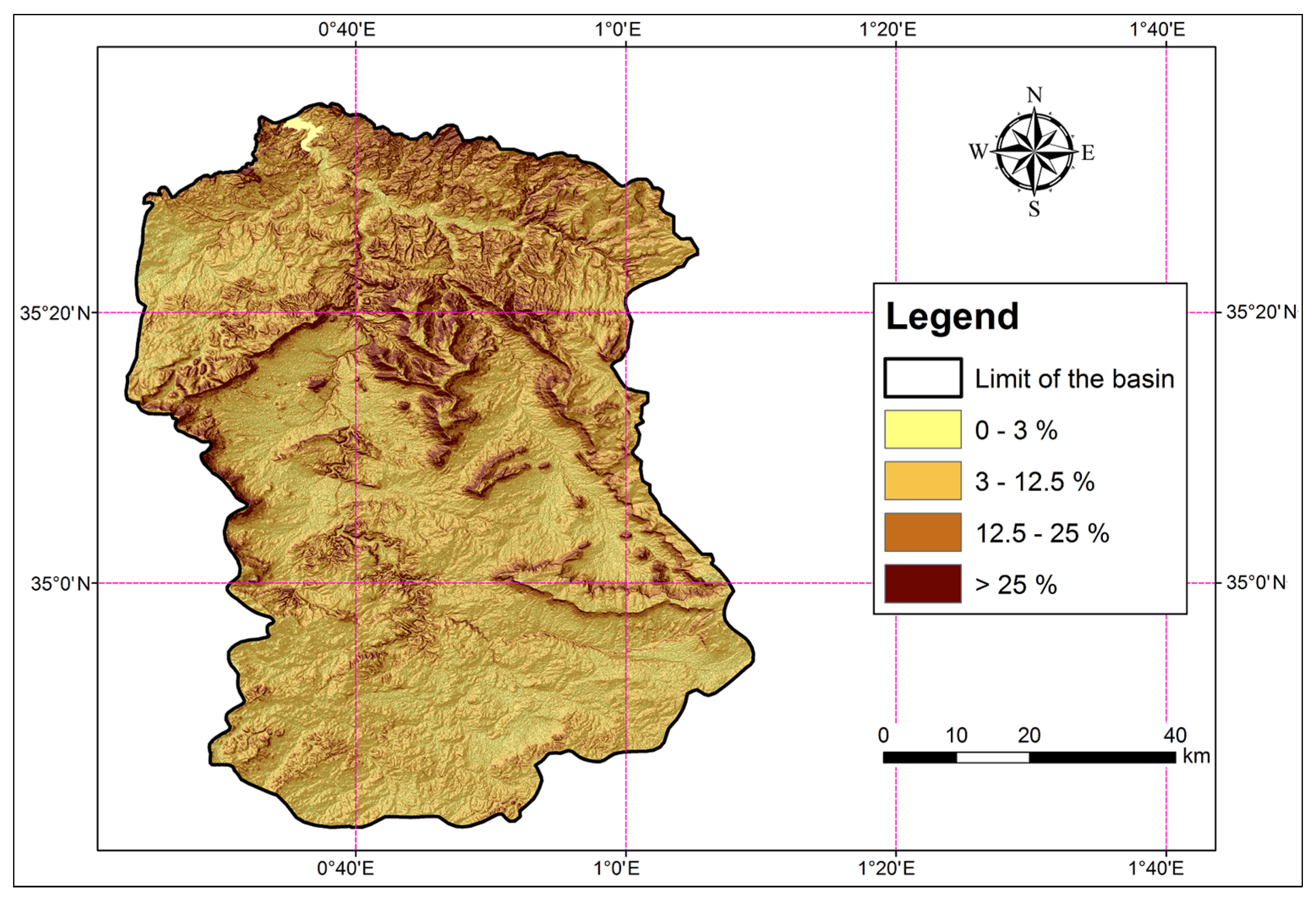
| Classes (%) | Area (km2) | Area (%) |
|---|---|---|
| 0–3 | 2672.95 | 54.55 |
| 3–12.5 | 1985.97 | 40.53 |
| 12.5–25 | 229.32 | 4.68 |
| >25 | 3.92 | 0.08 |
| Water bodies | 7.84 | 0.16 |
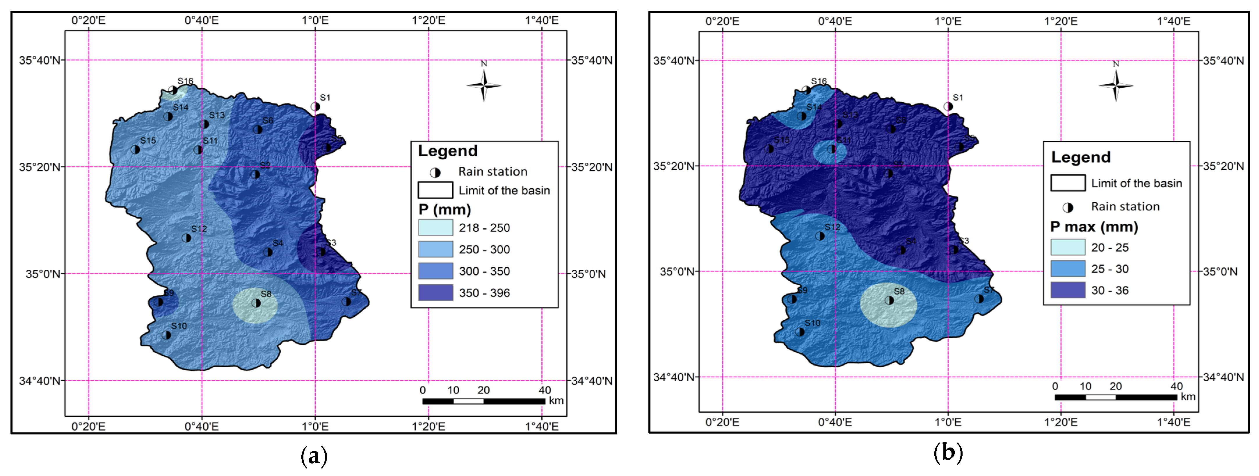
| Stations | Min | Max | Mean | SD | Cv | Cs | Ck | |||||||
|---|---|---|---|---|---|---|---|---|---|---|---|---|---|---|
| P′ | d | P′ | d | P′ | d | P′ | d | P′ | d | P′ | d | P′ | d | |
| S1 | 210.00 | 13.40 | 524.70 | 71.60 | 352.53 | 34.39 | 89.27 | 16.18 | 25.32 | 47.05 | −0.87 | 0.85 | 0.19 | −0.13 |
| S2 | 143.00 | 7.80 | 672.20 | 63.60 | 343.63 | 33.88 | 106.90 | 12.83 | 31.11 | 37.87 | 1.06 | 0.23 | 0.88 | 0.13 |
| S3 | 221.00 | 17.00 | 672.90 | 60.20 | 396.42 | 35.57 | 112.03 | 10.58 | 28.26 | 29.76 | 0.09 | 0.62 | 0.61 | −0.13 |
| S4 | 194.80 | 15.40 | 610.00 | 67.00 | 312.83 | 31.77 | 102.92 | 10.43 | 32.90 | 32.84 | 1.60 | 1.30 | 1.23 | 2.54 |
| S5 | 197.70 | 17.50 | 734.40 | 61.00 | 378.03 | 35.47 | 119.22 | 9.56 | 31.54 | 26.95 | 1.02 | 0.06 | 0.88 | −0.02 |
| S6 | 158.60 | 16.17 | 645.10 | 56.20 | 345.38 | 33.32 | 120.84 | 9.37 | 34.99 | 28.11 | 0.15 | 0.02 | 0.75 | −0.49 |
| S7 | 155.70 | 13.00 | 580.20 | 66.00 | 323.70 | 28.08 | 107.93 | 10.21 | 33.34 | 36.35 | 0.25 | 1.31 | 0.83 | 3.42 |
| S8 | 77.70 | 7.10 | 557.00 | 71.40 | 218.40 | 20.65 | 113.76 | 11.82 | 52.09 | 57.23 | 2.18 | 2.35 | 1.55 | 7.90 |
| S9 | 115.20 | 23.90 | 561.50 | 44.00 | 306.84 | 28.64 | 104.40 | 3.85 | 34.02 | 13.43 | 0.11 | 2.04 | 0.54 | 6.20 |
| S10 | 159.20 | 12.00 | 631.00 | 72.80 | 294.89 | 29.01 | 99.59 | 12.71 | 33.77 | 43.80 | 1.76 | 0.97 | 1.15 | 1.95 |
| S11 | 164.80 | 16.00 | 506.40 | 58.00 | 265.10 | 28.13 | 74.97 | 9.06 | 28.28 | 32.20 | 3.13 | 1.45 | 1.51 | 3.09 |
| S12 | 120.50 | 11.80 | 413.10 | 49.70 | 254.25 | 29.26 | 73.14 | 9.39 | 28.77 | 32.09 | −0.34 | 0.18 | 0.57 | −0.67 |
| S13 | 129.60 | 15.27 | 558.00 | 93.25 | 278.65 | 36.00 | 84.84 | 17.88 | 30.45 | 49.67 | 2.12 | 1.50 | 1.18 | 2.18 |
| S14 | 135.60 | 11.80 | 474.20 | 43.60 | 254.13 | 28.61 | 72.12 | 8.82 | 28.38 | 30.82 | 1.33 | −0.31 | 1.08 | −0.99 |
| S15 | 152.60 | 15.10 | 517.00 | 75.30 | 291.01 | 32.75 | 78.85 | 12.63 | 27.10 | 38.57 | 0.21 | 1.25 | 0.57 | 2.14 |
| S16 | 141.00 | 10.20 | 436.60 | 40.00 | 237.97 | 26.45 | 63.09 | 7.66 | 26.51 | 28.95 | 1.86 | −0.46 | 1.15 | −0.37 |
| Era | Area (km2) | Area (%) |
|---|---|---|
| Quaternary | 226.01 | 4.61 |
| Pliocene Continental | 225.56 | 4.60 |
| Upper Miocene | 154.21 | 3.15 |
| Lower Miocene | 296.26 | 6.05 |
| Oligocene | 272.32 | 5.56 |
| Middle Eocene | 13.49 | 0.28 |
| Lower Eocene | 52.81 | 1.08 |
| Upper Cretaceous | 53.22 | 1.09 |
| Lower Cretaceous | 136.42 | 2.78 |
| Middle Cretaceous | 115.40 | 2.36 |
| Upper Jurassic | 2341.68 | 47.79 |
| Middle Jurassic | 988.82 | 20.18 |
| Lower Jurassic | 6.86 | 0.14 |
| Triassic | 9.09 | 0.19 |
| Water | 7.84 | 0.16 |
| Large Type | Sub-Type | OM (%) |
|---|---|---|
| Cereal and forage farming | undifferentiated | 0–0.5 |
| Market gardening (vegetables, tubers) | in the greenhouse | >1.5 |
| traditional | >1.5 | |
| Recent burn | in agricultural zones | 0–0.5 |
| in the Steppic region | 0–0.5 | |
| in forested areas | 0.5–1.5 | |
| in maquis | 0.5–1.5 | |
| undifferentiated | 0–0.5 | |
| Arboriculture | undifferentiated | >1.5 |
| Forest plantation (undifferentiated) | <50% tree cover | 0.5–1.5 |
| 50–75% tree cover | 0.5–1.5 | |
| >75% tree cover | >1.5 | |
| Deciduous forest plantation | <50% tree cover | 0.5–1.5 |
| 50–75% tree cover | 0.5–1.5 | |
| >75% tree cover | >1.5 | |
| Resinous forest plantation | <50% tree cover | 0.5–1.5 |
| 50–75% tree cover | 0.5–1.5 | |
| >75% tree cover | >1.5 |
| Categorization of Erosion (t ha−1 Year−1) | Area (km2) | Area (%) |
|---|---|---|
| 0–5 | 3372.60 | 68.83 |
| 5–10 | 69.83 | 1.43 |
| 10–20 | 216.63 | 4.42 |
| 20–30 | 245.46 | 5.01 |
| 30–50 | 402.73 | 8.22 |
| 50–100 | 402.61 | 8.22 |
| >100 | 190.14 | 3.88 |
| Sub Basin N° | Area (km2) | Parameter | R (MJ mm ha−1 h−1 Year−1) | K (t h MJ−1 mm−1) | LS (/) | C (/) | A (t ha−1 Year−1) |
|---|---|---|---|---|---|---|---|
| Sub basin 01 | 4126 | Minimum | 326.10 | 0.02 | 0.00 | 0.01 | 0.00 |
| Maximum | 662.90 | 0.04 | 44.08 | 1.00 | 772.16 | ||
| Mean | 511.81 | 0.04 | 1.40 | 0.64 | 17.26 | ||
| SD | 81.45 | 0.00 | 2.98 | 0.08 | 35.29 | ||
| CV | 0.16 | 0.09 | 2.12 | 0.12 | 2.04 | ||
| Sub basin 02 | 480 | Minimum | 315.25 | 0.03 | 0.00 | 0.00 | 0.00 |
| Maximum | 421.78 | 0.04 | 35.86 | 1.00 | 343.61 | ||
| Mean | 373.74 | 0.04 | 1.34 | 0.63 | 12.00 | ||
| SD | 20.69 | 0.01 | 2.74 | 0.09 | 25.02 | ||
| CV | 0.06 | 0.14 | 2.04 | 0.14 | 2.09 | ||
| Sub basin 03 | 2480 | Minimum | 326.10 | 0.03 | 0.00 | 0.01 | 0.00 |
| Maximum | 662.90 | 0.04 | 39.35 | 1.00 | 489.39 | ||
| Mean | 539.11 | 0.04 | 1.26 | 0.62 | 16.06 | ||
| SD | 81.48 | 0.00 | 2.60 | 0.07 | 31.74 | ||
| CV | 0.15 | 0.10 | 2.06 | 0.11 | 1.98 | ||
| Sub basin 04 | 680 | Minimum | 447.36 | 0.03 | 0.00 | 0.01 | 0.00 |
| Maximum | 630.73 | 0.04 | 44.09 | 1.00 | 772.16 | ||
| Mean | 522.84 | 0.04 | 1.36 | 0.63 | 17.36 | ||
| SD | 40.07 | 0.00 | 2.92 | 0.08 | 36.21 | ||
| CV | 0.08 | 0.02 | 2.15 | 0.12 | 2.09 | ||
| Sub basin 05 | 1553 | Minimum | 456.49 | 0.03 | 0.00 | 0.01 | 0.00 |
| Maximum | 662.90 | 0.04 | 35.75 | 1.00 | 489.39 | ||
| Mean | 590.98 | 0.04 | 1.12 | 0.63 | 15.82 | ||
| SD | 39.22 | 0.00 | 2.10 | 0.06 | 29.74 | ||
| CV | 0.07 | 0.13 | 1.88 | 0.10 | 1.88 | ||
| Entire basin | 4900 | Minimum | 280.02 | 0.02 | 0.00 | 0.01 | 0.00 |
| Maximum | 662.90 | 0.04 | 44.08 | 1.00 | 772.16 | ||
| Mean | 490.94 | 0.04 | 1.41 | 0.64 | 16.69 | ||
| SD | 92.46 | 0.00 | 2.99 | 0.08 | 34.33 | ||
| CV | 0.19 | 0.08 | 2.12 | 0.12 | 2.06 |
| Sub-Basin | Wadi | Area (km2) | SRC | SSY (t km−2 yr−1) for 1970–2010 | RUSLE (t ha−1 yr−1) for 1970–2010 | SDR (%) |
|---|---|---|---|---|---|---|
| Sub basin 01 | Upstream Mina | 4126 | Qs = 3.50Ql1.38 | 271.45 | 17.26 | 15.73 |
| Sub basin 02 | Haddad | 480 | Qs = 3.48Ql1.38 | 975.45 | 12.00 | 81.27 |
| Sub basin 03 | Abd | 2480 | Qs = 2.27Ql1.65 | 227.42 | 16.06 | 14.13 |
| Sub basin 04 | Taht | 680 | Qs = 5.32Ql1.41 | 95.62 | 17.36 | 5.50 |
| Sub basin 05 | Abd | 1553 | Qs = 4.23Ql1.46 | 105.20 | 15.82 | 6.64 |
| Entire | Mina | 4900 | 320.41 | 16.69 | 19.20 |
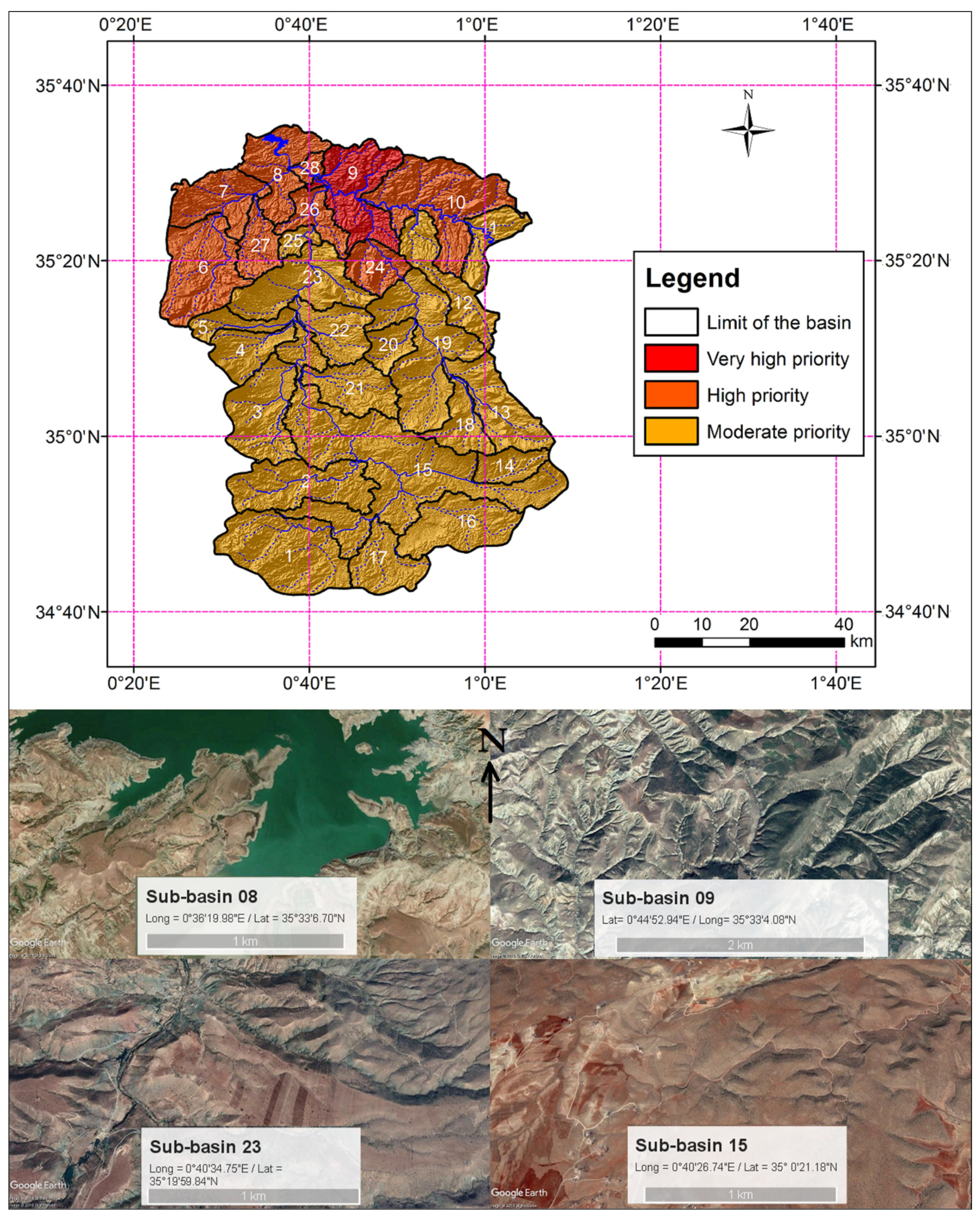
| Sub-Basin | Area (km2) | A (t ha−1 yr−1) | Distance to the Dam (km) | Intervention Priority |
|---|---|---|---|---|
| 1 | 305.70 | 17.03 | 100.33 | Moderate |
| 2 | 231.70 | 16.20 | 67.88 | Moderate |
| 3 | 213.79 | 16.50 | 41.60 | Moderate |
| 4 | 115.23 | 15.47 | 28.80 | Moderate |
| 5 | 129.62 | 17.79 | 26.40 | Moderate |
| 6 | 249.10 | 11.48 | 19.32 | High |
| 7 | 160.76 | 12.25 | 7.50 | High |
| 8 | 173.95 | 15.77 | 0.00 | High |
| 9 | 223.24 | 22.10 | 9.10 | Very High |
| 10 | 315.16 | 21.08 | 25.18 | High |
| 11 | 102.85 | 17.39 | 54.08 | Moderate |
| 12 | 164.75 | 19.87 | 37.98 | Moderate |
| 13 | 184.01 | 17.84 | 71.60 | Moderate |
| 14 | 83.56 | 19.03 | 92.14 | Moderate |
| 15 | 610.44 | 15.37 | 42.50 | Moderate |
| 16 | 216.00 | 14.78 | 86.38 | Moderate |
| 17 | 129.36 | 14.47 | 88.13 | Moderate |
| 18 | 93.72 | 16.07 | 76.10 | Moderate |
| 19 | 334.55 | 17.29 | 49.10 | Moderate |
| 20 | 66.43 | 18.39 | 61.04 | Moderate |
| 21 | 137.20 | 15.39 | 37.66 | Moderate |
| 22 | 124.23 | 15.84 | 47.63 | Moderate |
| 23 | 222.37 | 16.84 | 32.55 | Moderate |
| 24 | 90.34 | 21.39 | 36.50 | High |
| 25 | 32.52 | 18.62 | 27.09 | Moderate |
| 26 | 81.00 | 16.67 | 14.00 | High |
| 27 | 84.23 | 13.00 | 11.20 | High |
| 28 | 24.20 | 16.20 | 2.10 | High |
| Sum | 4900.0 |
Disclaimer/Publisher’s Note: The statements, opinions and data contained in all publications are solely those of the individual author(s) and contributor(s) and not of MDPI and/or the editor(s). MDPI and/or the editor(s) disclaim responsibility for any injury to people or property resulting from any ideas, methods, instructions or products referred to in the content. |
© 2025 by the authors. Licensee MDPI, Basel, Switzerland. This article is an open access article distributed under the terms and conditions of the Creative Commons Attribution (CC BY) license (https://creativecommons.org/licenses/by/4.0/).
Share and Cite
Achite, M.; Choudhari, P.; Toubal, A.K.; Caloiero, T.; De Marco, A.; Ouillon, S. Mapping Soil Erosion Potential in Algeria’s Wadi Mina Basin: Insights from Revised Universal Soil Loss Equation and Geographic Information System for Sustainable Land Management. Sustainability 2025, 17, 5038. https://doi.org/10.3390/su17115038
Achite M, Choudhari P, Toubal AK, Caloiero T, De Marco A, Ouillon S. Mapping Soil Erosion Potential in Algeria’s Wadi Mina Basin: Insights from Revised Universal Soil Loss Equation and Geographic Information System for Sustainable Land Management. Sustainability. 2025; 17(11):5038. https://doi.org/10.3390/su17115038
Chicago/Turabian StyleAchite, Mohammed, Pandurang Choudhari, Abderrezak Kamel Toubal, Tommaso Caloiero, Alessandra De Marco, and Sylvain Ouillon. 2025. "Mapping Soil Erosion Potential in Algeria’s Wadi Mina Basin: Insights from Revised Universal Soil Loss Equation and Geographic Information System for Sustainable Land Management" Sustainability 17, no. 11: 5038. https://doi.org/10.3390/su17115038
APA StyleAchite, M., Choudhari, P., Toubal, A. K., Caloiero, T., De Marco, A., & Ouillon, S. (2025). Mapping Soil Erosion Potential in Algeria’s Wadi Mina Basin: Insights from Revised Universal Soil Loss Equation and Geographic Information System for Sustainable Land Management. Sustainability, 17(11), 5038. https://doi.org/10.3390/su17115038