Article

Perceptions of a Water Reservoir Construction Project Among the Local Community and Potential Tourists and Visitors

by
Robert Machowski
1,
Martyna A. Rzetala
1,*,
Maksymilian Solarski
2,*,
Mariusz Rzetala
1,
Daniel Bakota
3,
Arkadiusz Płomiński
3 and
Katarzyna Kłosowska
4
1
Institute of Earth Science, Faculty of Natural Sciences, University of Silesia in Katowice, Będzińska 60, 41-200 Sosnowiec, Poland
2
Institute of Social and Economic Geography and Spatial Management, Faculty of Natural Sciences, University of Silesia in Katowice, Będzińska 60, 41-200 Sosnowiec, Poland
3
Faculty of Social Sciences, Jan Długosz University in Częstochowa, Waszyngtona 4/8, 42-200 Częstochowa, Poland
4
Independent Researcher, 40-432 Katowice, Poland
*
Authors to whom correspondence should be addressed.
Sustainability 2025, 17(11), 4796; https://doi.org/10.3390/su17114796
Submission received: 2 April 2025 / Revised: 12 May 2025 / Accepted: 21 May 2025 / Published: 23 May 2025

Abstract

A study was conducted concerning the perceptions of a future reservoir (4.7–8.9 square kilometres, 42.2 million cubic metres) by residents, tourists, and visitors; the location in question was the former Kotlarnia sand pit in the catchment area of the Bierawka River (tributary of the Oder River in southern Poland). Divergent concepts for the reclamation and development of the former sand pit emerged; the construction of a reservoir was initially the dominant option but was eventually abandoned despite it having the greatest acceptance among the respondents (out of the 134 respondents, 43.3% favoured the creation of a water reservoir, 29.9% favoured introducing nature protection arrangements in the area to enable spontaneous nature regeneration, and 16.4% favoured reforestation). A clear discrepancy arose between the public’s expectations related to the reclamation and development of the former sand pit in order to create a reservoir and the official position of the land user and administrator of the potential reservoir, which indicated that it no longer intended to create such a reservoir. This study indicates that in the process of developing concepts related to the reclamation and development of former mineral workings, it is essential to obtain the results of public consultation based on a diagnostic survey conducted among representatives of the local community. This is an effective tool for predicting the optimal use of sites regenerated after the damage caused by open-pit mining provided that all technical considerations related to the planned project are taken into account in advance.

1. Introduction

Human development has been closely linked to the use of natural resources and the associated impact on the geographic environment. Historically, the main factors determining resource utilisation were the steady increase in population and technological advances. Over the centuries, one of the commonly used raw materials was, and still is, sand, which has been extracted for construction purposes since ancient times [1]. It is estimated that sand and gravel quarrying is currently the world’s second-largest mining industry after fossil fuel extraction [2]. Owing to their wide range of uses and widespread availability, sand deposits are being extracted on an industrial scale from open sand pits. Outside of Antarctica, sand pits and gravel quarries are found on every continent, starting with the most ‘sandy’ ones (with the most deserts), such as Australia [3], Africa [4], Asia [5], and North America [6], but also in less obvious regions of the world, such as South America [7] and Europe [8].
Sand is extracted on an industrial scale from loose rock deposits of variable origin. Sand mining is conducted on many beaches and coasts around the world [9,10,11]. Worldwide, sand is also often sourced directly from river channels—in both small [12] and large rivers [13]. In the case of both of these aquatic environments, sand deposits are, in a sense, renewable resources. In the marine environment, sands are usually transported along coasts by coastal currents. Under favourable conditions (for instance, strong storms), sand deposits recover relatively quickly [14]. Similarly, in rivers, the replenishment of sediments within river channels occurs in a short period of time, for example, during large floods [15]. Sand mining and gravel quarrying in inland areas cause far more negative environmental effects. This is especially true of deposits that remained after the retreat of the ice sheet; these are situated especially in northern and central Europe as well as in North America [16].
Poland is among the many countries where sand mining is carried out on an industrial scale. The anticipated economic resources of sand and gravel in Poland are estimated at 21,131.8 million tonnes (of which developed deposits account for 6153.54 million tonnes), and economic resources amount to 4329.90 million tonnes [17], of which around 80% is mined in the Silesian Upland in the south of the country and also in adjacent areas in order to meet the needs of the numerous local coal mines [18]. Sand has been mined in these areas for more than 100 years. Surface rock quarrying has resulted in significant environmental transformation and has permanently altered the landscape [18].
Once a deposit has been abandoned, the areas degraded by quarrying should be rehabilitated. Sand pits where quarrying has ended are most often rehabilitated in three ways: by flooding them and creating water reservoirs, by reforesting them, or by backfilling them with waste rock from coal mines [8]. A relatively new trend in the development of former mineral workings is their use for the installation of hydroelectric power plants (including pumped-storage power plants) [19,20,21,22,23]. Hundreds of thousands of potential sites for hydroelectric power plants located outside of river channels have been identified globally, and with respect to mining areas, one research project alone has identified 904 locations around the world with a total storage capacity of 30 TWh [21,24]. As concerns the hydroelectric projects planned in former mineral workings, the following favourable factors are cited: conditions for power generation within these mineral workings, including existing power transmission infrastructure, water pumping infrastructure, transportation accessibility, public acceptance, low environmental impact, etc. [21]
Reclamation concepts based on the principles of optimising land use in accordance with natural compensation principles, environmental protection regulations, and sustainable development guidelines are of priority importance. The creation of a water reservoir at the site of the former mineral workings to meet the water needs of society falls within the scope of legally defined [25] social and economic development, within which framework the integration of political, economic, and social activities takes place, while maintaining the natural balance and sustainability of basic natural processes in order to ensure our ability to meet the basic needs of individual communities or citizens of both the present and future generations.
The steadily growing demand for water observed today is causing an increase in the amount of water retained in reservoirs. A common way to retain water is to impound rivers with dams. The construction of reservoirs within river valleys is a common way of regulating water relations. For this purpose, a dam is most often constructed in the river channel in order to control water flow. Such dams have been constructed to impound the largest rivers on Earth, such as the Nile River in Egypt [26], the Yangtze River in China [27], the Colorado River in the United States [28], the Paraná River in Brazil and Paraguay [29], and the Angara River in Russia [30], alongside many less spectacular structures [31]. Another frequently used solution, which at the same time is aligned with the principles of sustainable development, is the adaptation of depressions left by the surface mining of mineral resources. Former mineral workings that have been created within river valleys as a result of aggregate mining are also used to regulate river flows. For this purpose, the river is diverted into a reservoir from which water outflow to the original channel is controlled.
Irrespective of its origins, the creation of any new artificial lake entails a number of environmental consequences and causes socioeconomic transformations in the region. Any such project should be preceded by a series of environmental studies. The opinions of local communities most affected by these projects are a very important factor as well. Information from people who do not have direct links to the reservoir site is also proving helpful in the decision-making process. The best way to gauge public preferences is through various types of diagnostic surveys based on questionnaire forms. These surveys can be conducted in the traditional manner of face-to-face interviews, as well as using remote tools and electronic forms. In this manner, the perceptions of, for instance, lake water quality by people engaging in leisure activities, owners of summer cottages, and anglers were analysed [32]. A similar study was conducted in the context of assessing aquatic ecosystem protection among a local community living in a semi-arid northeastern region of Brazil [33]. Surveying various social groups with respect to the protection of water bodies is used as a tool for education and forms the basis of all environmental regulations and policies, especially in developing countries in sub-Saharan Africa [34]. Reservoir perception studies provide insights into the expectations of local communities related to the construction of both small reservoirs [35,36] and major ones [37]. Due to different expectations, especially at the design stage, academic reports indicate the need for stakeholder surveys to be conducted [38]. In extreme cases, neglecting to consult the local communities or insufficiently recognising their preferences can lead to an escalation of conflicts over the use of water resources [39].
In the literature, the first references to the reclamation of such areas appeared several decades ago. In the early 1970s, there were plans to liquidate the Kotlarnia sand pit in question by backfilling it with waste material generated by coal mining in the Upper Silesian Coal Basin, which is located several dozen kilometres to the northeast. The area thus levelled was subsequently to be planted with forest. The provisions included in the files compiled by local public authorities in the first half of the 1990s envisaged a reservoir or forest as the possible direction of the future development of those areas. Later, after various reclamation options had been analysed, it was found that creating a reservoir was the optimal and most promising option. In 2008, an agreement was reached between the Regional Water Management Board with its seat in Gliwice, the National Water Management Board, and the Kotlarnia sand mine to create a water reservoir in place of the former sand pit. At that time, the analyses required by law were carried out, and the documentation listing the assumptions related to the “Construction of the Kotlarnia Flood Control Reservoir on the Bierawka River” was drawn up [40]. In July 2023, decisions were made to update the technical documentation related to the construction of the reservoir. The new artificial lake would essentially be used to regulate water levels in the Bierawka River, which flows in its immediate vicinity, lowering these levels during floods and raising them during low water stages. The reservoir was also expected to fulfil leisure and recreational functions, as well as provide a boost to the economic development of the area after mining operations had been abandoned. The directions determined for the use of the reservoir are in line with the concept of sustainable development, meeting the requirements of modern landscape architecture and forms of development of the reservoir and its vicinity that are minimally invasive in terms of their natural impact, such as waterfront leisure, recreation, and tourism. The water reservoir construction project is also interesting in light of the Water Resilience Strategy of the European Union [41]. The European Water Resilience Strategy will develop a comprehensive multiannual cross-sectoral plan. The aim is to make Europe water-resilient, ensuring that water sources are properly managed and scarcity is addressed, strengthen the competitiveness and innovative edge of the European water industry, and take a circular economy approach (the plan will cover action in the EU as well as worldwide) [41]. Nevertheless, water quality is among the main factors determining the construction of a reservoir, and thus, water quality parameters are usually taken into account in concepts for the future use of water bodies [42]. Water quality assessment procedures primarily focus on the most significant threats resulting from variability in physical and chemical properties, i.e., thermal conditions and the occurrence of thermal pollution, oxygen conditions, including an assessment of the possibility of oxygen deficit and anoxia, water salinity, the potential development of eutrophication processes, the acidification or alkalinisation of waters, toxic metal pollution, etc. Therefore, limnic processes are very important for the overall use of the reservoir and the development of its vicinity.
It is extremely important to ask the public, and especially residents of the surrounding villages and towns, what they think about ideas of this kind and what they expect from the construction of an artificial lake. What risks do they see in a project of this type? These studies have been supplemented by information obtained from occasional visitors to the area around the future reservoir, as well as from potential tourists. This is because a project on this scale is not merely of local importance: its effects will also be felt on the regional and supra-regional scales.
The primary objective of this study is to identify the perceptions of the future Kotlarnia Reservoir, especially among the local community but also among visitors to the area and potential tourists.

2. Materials and Methods
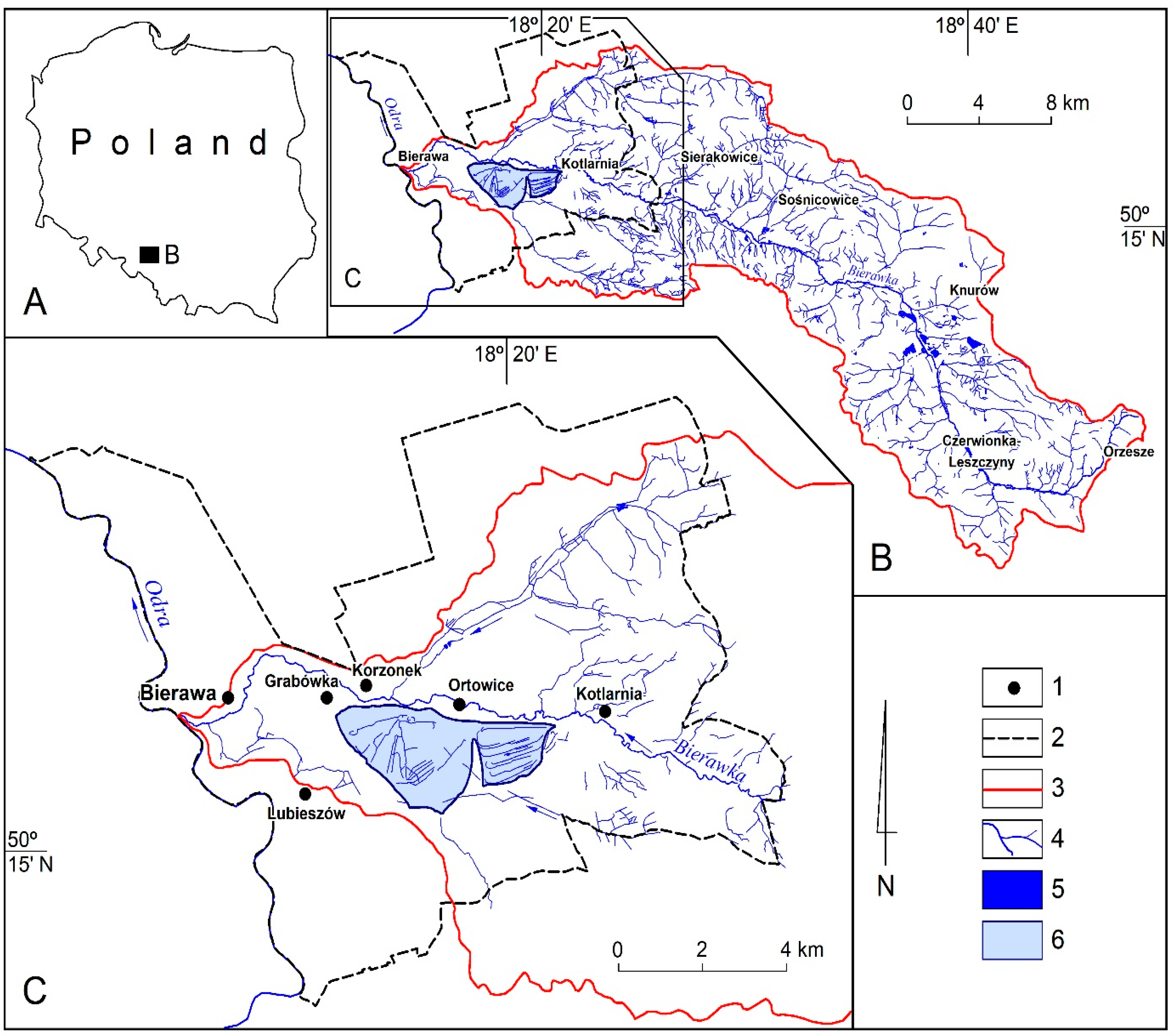
2.1. Study Area

The Kotlarnia sand pit is located in southern Poland, in the southeastern part of the Opole Province, within the Bierawa municipality, between the villages of Kotlarnia, Ortowice, Korzonek, Bierawa, Lubieszów, and Dziergowice (Figure 1). The pit from which the Kotlarnia sand mine extracted material to be used for hydraulic filling is located within the estuary of the Bierawka River valley, which flows at a distance of several dozen to several hundred metres north of the pit. The mine extracts material from deposits of sands and gravels formed during the North Polish glaciation, which have the form of meadow terraces situated 8.0–15.0 m above the level of the Oder River into which the Bierawka River flows below their location. These sedimentary formations include diagonally and horizontally layered sands and gravels, as well as fine- and medium-grained sands laminated with silts. Gravel horizons are usually found in the floor and ceiling of those profiles, and their centre consists of sands and silts [43]. The average deposit thickness reaches about 21 m, with a maximum of 25 m in places [44].
Much of the sand pit, where aggregates were mined in the past, has been planted with trees. In Polish conditions, the tree species most commonly used for the reclamation of sandy areas include the silver birch, Scots pine, European aspen, and goat willow. In some places, shrub, grass, and herbaceous communities also spontaneously formed [40]. In places where mining reached deeper parts of the profile, especially along the northeastern slope and near the southwestern boundary of the pit, waterlogged areas with characteristics of water bodies formed.
The water reservoir envisaged within the sand pit would include two water bodies connected by an isthmus, with different morphometric parameters; depending on the changing amount of the water stored in the reservoir, its area would range from 4.7 to 8.9 square kilometres (5.55 square kilometres at normal water level), and its total capacity would be 42.2 million cubic metres (including a flood reserve capacity of 25.32 million cubic metres). The planned average depth of the western water body would be 2 metres (from 1 to 2 metres in the southern part and up to 9 metres in the northern part), while the eastern water body, with a more even bottom, would have an average depth of about 5 metres. The maximum length of the Kotlarnia Reservoir shoreline would be just over 24 kilometres [40].
Due to the low quality of the surrounding soils, the immediate vicinity of the sand pit is overgrown with extensive forest complexes, mainly consisting of fresh mixed coniferous forest and wet mixed coniferous forest. Only within the surrounding villages is there a very limited area of land used for agricultural purposes. The entire catchment of the Bierawka River, amounting to 393.6 square kilometres, which is to feed the future reservoir, is also dominated by forest, accounting for just over 52% of its surface area. Agricultural land is generally present in the upper and partially also in the central part of the catchment area, accounting for around 35% in total. The remaining share of the catchment area is urban, especially in the upper part of the Bierawka River catchment, where larger towns and cities such as Orzesze, Czerwionka-Leszczyny, and Knurów are situated. In the rest of the catchment, built-up areas are scattered and limited to small towns such as Sośnicowice. A small percentage of the area within the Bierawka River catchment is occupied by standing water in the form of anthropogenic water bodies [45].

2.2. Field and Laboratory Data

The research carried out in the period from 2014 to 2023 was conducted using the following methods: library and online searches, field mapping, and the diagnostic survey method (using a survey questionnaire).
Library and online searches included both published and unpublished works on the Kotlarnia sand pit and reservoir, as well as the results of studies on perceptions of the construction of similar reservoirs around the world, hydrological data for the period of 1974–2023 [46], and data from 2023 on the physical and chemical parameters of the water intended to supply the reservoir [47].
As part of field mapping, the morphogenetic and hydrogenetic characteristics of the future reservoir were studied. This work consisted of mapping hydrological objects and phenomena in the study area. The work was carried out several times between 2014 and 2023.
The survey method (using a survey questionnaire) was conducted from 18 February 2023 to 21 June 2023 among a total of 134 respondents. The sample size (134 respondents) is close to 1% of the total population of the surrounding area and a similar number of potential tourists and visitors (the survey ended when the sample size reached a level considered representative). This group included 71 respondents who live near the future reservoir, and 63 potential tourists and occasional visitors to the area. In total, 74 respondents were interviewed face-to-face, and 60 completed survey forms remotely using the Google Forms platform. A total of 85 women and 48 men participated in the survey; 1 person did not provide a response in this regard. The respondents included 1 person under 18, 65 people aged from 18 to 30, 17 people aged from 31 to 40, 7 people aged from 41 to 50, 13 people aged from 51 to 60, 21 people aged from 61 to 70, and 10 people over 70. Of the respondents, 8 had a primary education, 31 had completed vocational school, 49 had completed secondary school, and 46 respondents declared a university degree (Figure 2).
The survey questionnaire (Supplementary Materials File S1) included more than a dozen questions for respondents (questions numbered 1–4, 9, and 12 were single-choice, while in the remaining questions, more than one answer could be selected):
  • Have you heard about the plan to construct the Kotlarnia Flood Control Reservoir on the site of a former sand pit?
  • Do you agree with the plan to construct the Kotlarnia Reservoir on the site of a former sand pit?
  • What land reclamation direction would you like to see in this area?
  • Which reservoir development option do you think should be implemented?
  • What benefits do you think the construction of the Kotlarnia Reservoir could bring?
  • Please list the problems you think could be associated with the construction of the reservoir.
  • What impact will reservoir construction have on local communities?
  • What environmental consequences will the construction of the reservoir have for the surroundings?
  • In your opinion, will the construction of the reservoir cause much damage to households?
  • What development options would you propose for the vicinity of the reservoir under this project?
  • What reservoir development options would you propose for this project?
  • In your opinion, would the reservoir significantly affect the attractiveness of the surrounding towns and villages and boost interest in the region?
  • What measures do you think should be taken to minimise the negative impact associated with the construction of the reservoir on plants and animals in its vicinity?
  • What measures do you think should be taken to minimise the negative impact associated with the construction of the reservoir on households?
The survey on the perceptions of the concept of constructing a reservoir in former mineral workings also included data on water flows in the watercourse that would potentially provide the main source of water supply to the reservoir. The calculations used the minimum, average, and maximum monthly flows from the hydrological years 1986–2023 as a representative period for the reservoir construction project considered (the data are in the public domain [46]). The research procedure aimed at assessing the general potential of the reservoir being filled; thus, calculating the theoretical time required for the reservoir to be filled with surface waters involved determining multiannual average flows (SSQ), low average flows (SNQ), and minimum environmental flows (Qn). Water flowing within river channels can only be used to ensure a minimum environmental flow, that is to say, the amount of water necessary to ensure biological life in the watercourse and the entire ecosystem. The minimum environmental flow was determined using a formula developed by H. Kostrzewa [48], which made it possible to calculate the theoretical time required for the reservoir to be filled (Equation (1)):
Qn = k · SNQ
where
  • Qn—minimum environmental flow [m3/s];
  • k—parameter determined empirically depending on the hydrological type of the catchment and its surface area (for the watercourse under consideration, it equals 1.27);
  • SNQ—average low flow (the average among the minimum annual flows within the multiannual period of 1986-2023) [m3/s].
The minimum environmental flow (Qn) and the average annual flow in a multiannual period (SSQ) were used to calculate the amount of water from the watercourse that could be used for supplying the reservoir (QS) [Equation (2)]. Due to the fact that the watercourse feeds the reservoir in its final section, the formula omits the so-called required flow, which should remain in the river channel to meet the needs of its other users; this required flow is determined according to the following criteria: operational, landscape, recreational fishing, and navigation, taking into account the hierarchy of system users.
QS = SSQ − Qn
where
  • QS—the amount of water in the watercourse that can be used to supply the reservoir [m3/s];
  • SSQ—average annual flow within a multiannual period [m3/s];
  • Qn—minimum environmental flow [m3/s] (the hydrological survey methodology does not account for the occurrence of very low water stages caused by the extreme drought in 2019, in which SSQ < Qn; in these circumstances, the minimum environmental flow should be adopted as SSQ, and water from the watercourse should not be used to feed the reservoir).
The following formula was used to calculate the theoretical filling time of the reservoir (expressed in days) [Equation (3)].
TV = VU/(P – E + ∆Rc + Qy) × t
where
  • TV—theoretical time to fill the reservoir with water [days];
  • VU—usable reservoir capacity (not including flood reserve) [million cubic metres];
  • P—the estimated annual amount of precipitation delivered to the reservoir [million cubic metres];
  • E—the estimated annual amount of water evaporation from the reservoir [million cubic metres];
  • ∆Rc—the annual balance of water exchange with the sub-surface catchment area [million cubic metres];
  • Qy—the annual amount of water in the supplying watercourse that can be used to supply the reservoir [million cubic metres];
  • t—multiplier allowing the theoretical reservoir filling time to be expressed in days (number of days per year).
The annual amount of precipitation delivered to the reservoir [million cubic metres] was estimated on the basis of the average annual precipitation within a multiannual period (711 mm [49]) and the area of the reservoir at the normal water level (5.55 km2). The same reservoir area and the average annual evaporation within a multiannual period (670.2 mm [50]) were taken into account when estimating the annual amount of water evaporation from the reservoir [million cubic metres]. The annual balance of water exchange with the sub-surface catchment was estimated assuming the spontaneous regeneration of the groundwater table after the dewatering of former mineral workings has ceased. Based on the amount of water pumped out from the former mineral workings per year [51], resulting from groundwater exchange in the sub-surface catchment area, the inflow of groundwater into these workings during the reservoir filling period was assumed at an average rate of 0.32 m3/s, i.e., 10.176 million m3 (in the period after the reservoir has been filled, it can be assumed that water exchange with the sub-surface catchment will become balanced).
This study took into account the most important water quality parameters as determined by state environmental monitoring for the watercourse envisaged as supplying the future reservoir. Tests of physical and chemical properties of water were carried out with respect to 27 indicators by environmental monitoring services, using officially sanctioned measurement methods and techniques (the raw data are in the public domain [47]). Water temperature was measured directly in the field. Dissolved oxygen was determined using the electrochemical sensor method. BOD5 was determined using the electrochemical method in undiluted samples. Titration was used in the determination of CODMn, chloride, total hardness, and total alkalinity. Total organic carbon, CODCr, ammonia nitrogen, Kjeldahl nitrogen, nitrite nitrogen, and total phosphorus were determined using the spectrophotometric method. Specific electrical conductivity was determined using the conductometric method. The gravimetric (weight) method was used to determine dissolved substances. Ion chromatography was used for the determination of sulphates and nitrate nitrogen. The ICP-MS method was used to determine calcium, magnesium, lead, cadmium, and nickel content. The potentiometric method was used to determine water pH, a calculation method was used to determine total nitrogen, flow analysis was used to determine phosphate phosphorus concentration, and the HPLC-FLD method was used to assess benzo(a)pyrene content.
The tests involved the use of simple statistical analysis indicators, metrics, and tools, e.g., minimum and maximum values, arithmetic mean, median value, and standard deviation. Formulas were also used to support the analysis of changes in the physical and chemical properties of the waters, namely to calculate the multiples by which minimum and limit values (Equation (4)) were exceeded with respect to surface water quality classes in a lowland river with a sandy loam substrate (Equation (5)).
IE = PVmax/PVmin
where
  • IE—the multiple by which the minimum value was exceeded (unitless);
  • PVmax—the maximum value of the physical/chemical parameter during the study period;
  • PVmin—the minimum value of the physical/chemical parameter during the study period.
IHB = PVmed./VHB
where
  • IHB—the multiple by which the physical/chemical parameter exceeded the limit for surface water quality classes in a lowland river with a sandy loam substrate (unitless);
  • PVmed.—the median value of the physical/chemical parameter during the study period;
  • VHB—the limit value for the surface water quality classes of a given physical/chemical parameter of water in a lowland river with a sandy loam substrate (in accordance with the figures contained in the Regulation of the Minister of Infrastructure of 25 June 2021 on the classification of ecological status, ecological potential, and chemical status, and the method of classifying the status of uniform surface water bodies, as well as environmental quality standards for priority substances [52]).
The IE index has a value of IE = 1.0 in the absence of variation in the value of the physicochemical parameter analysed, and IE > 1.0 where this variation is present (rising with the difference between the maximum value and the minimum value of this physicochemical parameter during the period under consideration). The values of the IHB index should be interpreted similarly, with values of physicochemical parameters during the study period being compared against the limits for surface water quality classes in a lowland river with a sandy loam substrate. The IHB index is IHB < 1.0 when the value of the physicochemical parameter in question is less than the limits for surface water quality classes in a lowland river with a sandy loam substrate, and it is IHB > 1.0 when these limits are exceeded, rising with the multiple by which they are exceeded.

3. Results

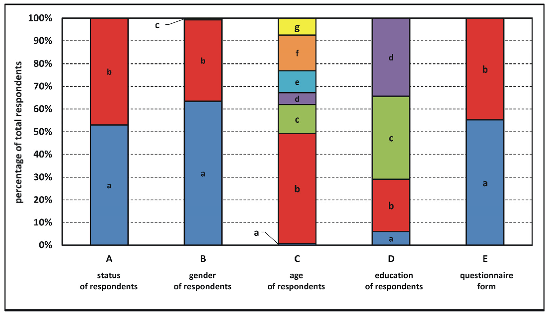
3.1. Diagnostic Survey Results

In total, 61.2% of all respondents, including 84.5% of all residents surveyed and 34.9% of respondents from the tourist and visitor group, had heard of plans to build a reservoir in Kotlarnia on the site of the former sand pit. In total, 15.5% of residents and 65.1% of potential tourists surveyed had never heard of the planned project.
In total, 70.4% of residents and 47.6% of potential tourists expressed positive attitudes towards the construction of the reservoir, and a high proportion of respondents did not express any opinion—47.6% of tourists and 14.1% of residents. In total, 15.5% of residents and only 4.8% of prospective tourists expressed negative opinions on the construction of the reservoir.
Of the reclamation directions proposed, respondents most favoured the reservoir option, which was selected by more than 49.3% of residents and 36.5% of other respondents. The second most popular option involved, for instance, establishing a nature conservation area. In total, 23.9% of residents and 36.5% of non-residents were in favour of this option. Turning the sand pit into a forest came third, with 18.3% of residents and 14.3% of potential visitors to the area favouring this direction of reclamation. Other solutions received little support in both groups of respondents.
As concerns the role of the future reservoir, three options garnered comparable support in both groups. The flood control function was selected by 59.2% of residents and 50.8% of other respondents, the recreation function was supported by 56.3% of the local community and 49.2% of potential tourists, and the possibility of retaining water for purposes such as reducing the effects of drought was indicated by 40.8% of respondents who permanently live in the vicinity of the sand pit and by 66.7% of those from outside the area. In either group surveyed, the other responses did not meet with much favour.
Local residents indicated that four benefits resulting from reservoir construction were equally important: the possible development of tourism (supported by 53.5% of respondents in this group), drought protection (53.5%), as well as flood safety (52.1%) and fire safety (52.1%). Among respondents from outside the area, the most popular benefits were opportunities for tourism development (79.4%) and flood safety (60.3%).
The largest percentage of residents surveyed (25.4%) were unable to point to specific risks associated with the project. Of the several possibilities, they most often pointed to fluctuations in groundwater levels (22.5%) and the clearing of large numbers of trees (22.5%). According to 15.5% of people, noise would be a nuisance during the reservoir construction phase. Among the other respondents, responses were generally similar: 36.5% of people indicated problems caused by excessive noise, with slightly fewer respondents mentioning fluctuating groundwater levels and the clearing of large numbers of trees (33.3% of respondents each).
Among the possible effects of the reservoir’s construction for the local communities, both surveyed groups indicated an increase in tourism—57.7% among residents and 61.9% among tourists. The residents’ responses were fairly evenly distributed among the other options: an increase in property prices—32.4%, a change in local microclimate—23.9%, an increase in air humidity near the reservoir—23.9%, an increase in exhaust and dust pollution in the construction phase—19.7%, and problems associated with increased traffic—16.9%. Among potential tourists, changes in the local climate and microclimate were the second indication (52.4%). The other options were mentioned far less often.
Regarding land relief, nearly half (49.3%) of residents could not identify specific impacts. The same answer was also selected by 38.1% of potential tourists. Residents (26.8%) and tourists (41.3%) most often pointed to possible landslides as a threat. More definite indications from residents were concerned with changes in soil conditions. Elevated groundwater levels (38.0% of respondents) and soil becoming waterlogged (33.3%) were mentioned most often. Waterlogging was the predominant concern among potential tourists, with 52.4% of indications; 46.0% stated that they had no knowledge in this respect. With regard to vegetation, respondents were unanimous in citing tree felling as the main effect. This view was expressed by 52.4% of tourists and 31.0% of residents. With regard to animals, residents pointed to changes in habitat conditions (33.8%), as did tourists (63.5% of responses).
According to respondents, the construction of the reservoir in the proposed location would not cause damage to households. This opinion was expressed by 63.4% of residents and by 41.3% of those outside the study area.
Of the various options for developing reservoir shores, residents most often pointed to the possibility of constructing cycling routes (60.6%) and building recreational infrastructure (56.3%). The potential tourists’ responses were somewhat differently distributed. Within this group, tree planting was indicated by 60.3%, other plantings by 58.7%, and cycling routes also by 58.7%.
According to the largest number of residents (66.2% of respondents), the reservoir itself should be a bathing resort and provide opportunities for recreational fishing (52.1%). In the second group surveyed, the most common suggestion was the possibility of building artificial islands for bird nesting purposes—63.5% of respondents. Slightly less popular were the concepts of a bathing resort (49.2% of responses) and a water sports facility (47.6%).
Most locals believed that the presence of the reservoir would increase the attractiveness of the surrounding area and boost interest in the entire region. In the survey, this view was expressed by 77.5% of the total residents surveyed. Only 5.6% of residents held the opposite view. Nearly 17% had no specific views on the subject. Among potential tourists, the vast majority (85.7%) of respondents were convinced that the reservoir would significantly increase the attractiveness of the area. Only 4.8% of respondents expressed the opposite opinion. On average, 1 in 10 (9.5%) of the respondents in this group were unable to express an opinion.
According to respondents, in order to minimise the negative effects of the construction of the reservoir on the animals and plants in its vicinity, construction work should begin outside of the animal breeding season and growing season (68.3% of tourists; 25.4% of residents), and forested areas should be left untouched (tourists—54.0% of respondents; residents—35.2% of indications).
The adequate protection of construction sites and temporary facilities was the most common option chosen by both groups surveyed when asked how to reduce the negative effects of reservoir construction on households. This answer was indicated by 36.6% of residents and 65.1% of tourists. The need to secure the stability of the shores of the future lake was pointed out less often. This option was favoured by 31.0% of residents and 52.4% of tourists.

3.2. Changes in the Quantity and Quality of Water

The results of studies concerning the possibilities of supplying the former mineral workings with water indicate that the most important source feeding the reservoir would be the flowing surface waters of the Bierawka River (Supplementary Materials File S2, Figure 3, Table 1). From 1986 to 2023, the flow of water in this watercourse ranged from 0.18 m3/s to 104.0 m3/s, averaging 2.40 m3/s. The minimum environmental flow in the watercourse in the area of the former mineral workings was set at 1.19 m3/s. The average amount of water available for filling the reservoir was estimated at 1.21 m3/s, which, assuming that the reservoir would be filled to its normal operating level, corresponding to a capacity of 16.89 million cubic metres, would take about 127 days.
The results of studies of the physicochemical properties of water that could potentially be used to supply the Kotlarnia Reservoir vary considerably and deviate from the levels considered natural. The multiples by which the minimum values and reference limit values for surface water quality classes in a lowland river with a sandy loam substrate are exceeded indicate very high human impact (Table 2). This is evidenced, for instance, by the slight thermal pollution load of the waters in question, but this load was not sufficiently significant to disturb the natural variation in thermal conditions in the new dimictic reservoir. The observed hyperoxygenation of waters may be indicative of mechanical oxygenation caused by turbulent flow, but primarily of the development of eutrophication processes, which are confirmed by the concentrations of nutrients that deviate from the levels accepted as natural. In addition, the water exhibits very high salinity, which may degrade the ecosystem of the reservoir, and the water may also have a corrosive effect on hydraulic structures. The presence of toxic metals in water may result in their accumulation in the bottom sediments of the future reservoir.

4. Discussion

The retention capabilities of the Kotlarnia Reservoir will be used to regulate water levels on the Bierawka River flowing from the north, which will be diverted into the reservoir. This will make it possible to temporarily retain excess river water during high water stages and supplement flows during water shortages caused by low water stages.
The scale of water surpluses and deficits in the Bierawka River catchment is illustrated by the values of the highest (104.00 m3/s) and average (19.93 m3/s) flows among the maximum annual flows, and the lowest (0.18 m3/s) and average (0.94 m3/s) flows among the minimum annual flows, especially in the context of the average annual flow in the years 1986–2023, which amounted to 2.40 m3/s (Figure 3, Table 1). The reservoir would regulate the amount of water in the Bierawka River during both high and low water stages. With an average flow rate of 1.80 m3/s, the average theoretical filling time of the reservoir would be about 4 months; this would be significantly reduced during high water stages and much longer during low water stages. In practice, the filling time could be modified due to the following factors: the inflow of groundwater within the depression cone after deposit dewatering has ceased (the effectiveness of this recharge source would gradually decrease with the reservoir filling), the contribution of precipitation, losses due to evaporation and the filtration of water into the ground. Nevertheless, the available water resources would certainly ensure that the reservoir would be filled and that it would fulfil its retention functions, including flood control (with a flood reserve capacity of around 25.32 million cubic metres) and drought protection. The vast majority of respondents were in favour of such solutions, especially seeing the protection of floodplains against floods as a desirable outcome. Typically, slightly less significance was assigned to levelling the effects of droughts, which, unlike floods, develop slowly and generally do not pose a threat to human life and health.
The hydrological impact of the reservoir via the Bierawka River should also be considered in supra-regional terms. The Bierawka River is one of the larger right-bank tributaries of the upper Oder River, which is characterised by considerable seasonal fluctuations in water levels. Catastrophic floods have repeatedly occurred on this river in the past [53]. There is barge traffic on the Oder River, which is restricted during low water stages. In such circumstances, outflow from the reservoir will be increased to feed the Bierawka River and subsequently the Oder River. Analogous functions are performed by the reservoirs included in the Kłodnica River hydrotechnical system: the Pławniowice, Dzierżno Duże, and Dzierżno Małe Reservoirs [54]. In the northern part of the Silesian Upland, the Kuźnica Warężyńska Reservoir was constructed in a former sand pit, and it also performs flood control functions. This reservoir has a flood reserve of just over 8 million cubic metres, reducing surges on the Black Przemsza River [55]. There are three reservoirs in former sand pits in the immediate vicinity, the Pogoria I, Pogoria II, and Pogoria III Reservoirs, through which the Pogoria River cascades. These reservoirs can also be used for the purpose of regulating the water flows in the river [56].
The vast majority of respondents mention leisure and recreation opportunities as positive aspects of constructing a reservoir in the study area. The construction of reservoirs for such purposes is especially desirable on the outskirts of highly urbanised areas, as this makes it easy for large populations who live in such areas to access the artificial lake. The creation of reservoirs, especially in depressions created by former sand pits, promotes water-based recreation. Shores consisting of loose sandy material create conditions almost identical to those found on seaside sandy beaches. In addition, the technical treatments necessary are not as labour- and cost-intensive as would be the case with more resistant bedrock. The need for constructing such reservoirs throughout the region is evidenced by the large number of artificial lakes in former sand pits on the neighbouring Silesian Upland to the east. Among the most popular of such reservoirs are the Pogoria I, Pogoria II, Pogoria III, Kuźnica Warężyńska, Rogoźnik I, Rogoźnik II, Dzierżno Małe, Dzierżno Duże, Pławniowice, Dziećkowice, Sosina, Stawiki, Borki, Morawa, Hubertus I, Hubertus II, and Hubertus III [56]. In addition to the obvious leisure opportunity of sunbathing, respondents also cited more active ways to spend time. In their opinion, the Kotlarnia Reservoir would offer opportunities for sailing, canoeing, fishing, motorboat sports, and diving, among others. These activities usually take place in the warm season, when the water is at the right temperature. In colder periods, the lake’s surroundings would also provide very favourable conditions for a wide range of physical activities, such as walking, Nordic walking, running, cycling, rollerblading, etc. In the colder season, these areas would be used primarily by the local communities. In summer, the reservoir would be more crowded. Studies conducted in the region indicate that the area would be equally visited by residents of the industrialised Silesian Upland, which is located a few dozen kilometres to the east [57]. The need for the construction of such reservoirs in the vicinity of large cities is also confirmed by data on the growing number of tourists who visit lakes in former mineral workings located in the Central German lignite mining region for recreational purposes [58]. In extreme cases, even reservoirs that exhibit elevated concentrations of metals in the water are used for recreational purposes. Surveys among residents of the Collie Coal Mining District in southwestern Australia have demonstrated that such lakes are highly popular. Of the various possible activities, respondents most often indicated swimming [59].
Opportunities for the tourist use of the reservoir depend primarily on the quality of the water retained therein because this parameter determines possibilities for various forms of recreation to be implemented. The presence of toxic contaminants in the water or bottom sediments virtually precludes the safe use of lake waters, and bacteriological contamination has similar consequences [60]. The presence of above-normal concentrations of nutrients may cause severe algal blooms, which also rules out bathing, for instance [61]. However, it is still safe to sail or fish in such waters [62]. The Bierawka River, which will flow through the Kotlarnia Reservoir, exhibits elevated concentrations of substances that increase water salinity. This should not significantly restrict the use of the artificial lake for leisure and recreational purposes. Studies indicate that saline limnic environments found in various dry regions have unique natural values [63,64]. Reservoirs constructed in former aggregate workings create favourable conditions for many species of fish to thrive and multiply [65]. This, in turn, makes them highly attractive for anglers who are very eager to fish in such waters. Reports of the use of reservoirs in former mineral workings for recreational fishing come from, among others, Germany [62], France [66], the Czech Republic [67], the United States [60], Canada [68], and even Australia [68]. There are also known cases of such lakes being used for farming purposes—other aquatic organisms, such as shrimp, snails, etc., can be farmed in addition to fish [69].
The use of the water retained in the reservoir to generate electricity could undoubtedly be a positive aspect of its operation. This issue has not yet been articulated in either the hydrological engineering concepts for constructing the reservoir in the former sandpit or in the respondents’ opinions. Only 5.6% of community representatives and 12.7% of tourists and visitors were in favour of using the reservoir for hydroelectric power generation—the lowest percentage in both groups of respondents; other forms of reservoir use, e.g., for recreation, water sports, boating, fishing, or nature conservation, were favoured far more frequently. Meanwhile, conditions are favourable for the construction of a small hydropower plant in view of the possibility of achieving an appropriate water head and obtaining an effective flow at the reservoir outlet. Hydroelectric power generation within the discussed site would be an example of activities that align with the idea of sustainable development through the use of renewable energy sources.
Surface sand mining results in the serious degradation of the natural environment at every stage of sand-pit operation, and thus, special measures should be taken to mitigate negative environmental impacts after the site has been abandoned [70]. The creation of a reservoir in a former sand pit is one way to rehabilitate degraded land [71]. Undoubtedly, the sheer scope of construction work in the initial phase requires the bottom and shores of the future reservoir to be adequately prepared and secured. It is necessary to lay out access roads. All these activities will involve clearing trees and destroying vegetation [18,72]. These are also the most significant risks identified by respondents when asked about the impact present during the construction period of the reservoir. Respondents also mentioned inconvenience in the form of increased noise and exhaust emissions due to the use of heavy construction equipment during the construction of the reservoir among the negative aspects. The construction of artificial reservoirs within river valleys causes comprehensive changes to the geographic environment, both below and above the water level in the lake. The most visible effects are present in its immediate vicinity, but the impact on aquatic ecosystems may extend far beyond the local scale [73,74,75]. As concerns these aspects, respondents cited changing habitat conditions, causing the evolution of plant communities and animal species composition, as the greatest threat.
Despite the significant improvement in landscape qualities, some of the adverse effects of creating an artificial lake cannot be completely eliminated due to the very nature of the project [76]. A small segment of respondents believed that the construction of the reservoir would not result in any harmful impacts. This may also be due to the fact that out of the many possible negative scenarios, a significant percentage of respondents were unable to identify specific impacts. On the other hand, the problems associated with the construction of the reservoir, according to those respondents who did point out such impacts, would primarily be related to fluctuations in groundwater levels. The abandonment of sand mining makes it possible to discontinue the dewatering of the sand pit. This is a standard procedure that is implemented at the mine abandonment stage. It results in the depression cone being gradually filled as a result of a rise in groundwater levels, and eventually, water emerges in the sand pit [77]. In this manner, lakes emerge in former mineral workings in many places, including in dry regions where lakes do not usually occur under natural conditions [78,79]. In Western Australia, these lakes mostly fill in depressions left by surface gold mining. The formation of such water bodies involves threats related to, among other things, the contamination of waters with heavy metals and elevated salinity due to intense evaporation. In Australia, a river was connected to Lake Kepwari that emerged as a result of open-pit coal mining. Connecting the river to the lake improved the water quality in the lake, but at the same time, it negatively affected the chemical parameters of the water in the river below [60]. In the case of the Kotlarnia Reservoir, these threats will stem from the inflow of the polluted waters of the Bierawka River, which is expected to flow through the reservoir. The river receives saline water produced as a result of the dewatering of coal mines located in the upper part of its catchment [80]. It is the water pollution, including salinity that reaches several grams per litre, in the main watercourse that would feed the Kotlarnia Reservoir, which raises the greatest concerns related to the ecological status of that reservoir. The quality of water in the Bierawka River, as the main watercourse feeding the Kotlarnia Reservoir, is determined primarily by industrial activity and urbanisation processes; these water resources exhibit an above-normal concentration of many chemicals, especially those that cause salinity (Table 2). The highly degrading impact of polluted and saline waters on the limnic ecosystem is evidenced by the nearby Dzierżno Duże Reservoir (with a maximum capacity of 94 million cubic metres) in the Kłodnica River basin [81], where, in the summer of 2024, more than 120 tonnes of fish (perch, carp, pike, zander) died, inter alia, due to the high salinity of the water and a golden alga bloom [82]. Another common phenomenon observed in artificial lakes is eutrophication, which is associated with nuisance algal blooms [83]. This is a particularly unfavourable phenomenon in the context of the recreational use of water bodies, as the massive appearance of phytoplankton forces the temporary closure of bathing areas. This phenomenon is most often observed during the holiday season, when reservoirs are visited by crowds of people [84]. In the case of the Kotlarnia Reservoir studied here, an uncontrolled increase in water fertility associated with massive phytoplankton growth is highly likely in view of phosphate concentrations averaging several milligrams per litre and nitrogen compound concentrations ranging from a few to a dozen milligrams per litre.
The results of the studies conducted generally align with the outcomes of analyses carried out in other regions of the world. Respondents see both the positive and negative effects of reservoir construction. The benefits associated with the creation and operation of artificial lakes are more commonly acknowledged. This is confirmed by reports not just from other regions of Poland [35,36]. Surveys conducted in Spain—in two regions with contrasting climates and water security levels—showed that the majority of respondents in both cases viewed the construction of hydroelectric dams favourably. Compared to the humid Asturias region, respondents in dry Málaga were more supportive of dams [85]. In Germany, Portugal, and Sweden, the majority of respondents were in favour of hydropower due to its role in mitigating the climate change observed, among other things [86]. This is also supported by research from Austria, where the data obtained clearly pointed out the Austrians’ willingness to bear the additional economic and environmental costs of hydroelectric power generation. This study confirmed the prevalence of the “not in my backyard” phenomenon. Respondents favour the construction of new projects, but not near their homes [87]. Similar patterns were found in Brazil. People living near the Belo Monte Dam—the second largest in the country—hold less favourable views compared to the rest of the country’s population. However, more than 60% of residents of the Altamira municipality, where the dam is situated, express support for hydropower [88].

5. Conclusions

The research conducted gives rise to certain conclusions that may serve as guidance to the administrators of similar sites around the world with respect to the reclamation and management of land transformed as a result of open-pit mineral extraction.
  • The concept of the reclamation and management of the former sand pit has clearly evolved from the view (dominant a decade ago) that a reservoir should be created in its place, which would serve flood control and recreational functions, to the reforestation of the area and spontaneous vegetation succession that is promoted today.
  • Among the considered sand-pit reclamation and development directions, the following ones gained the greatest acceptance: the creation of a water reservoir (43.3% of respondents), nature protection arrangements in the area to enable spontaneous nature regeneration (29.9% of respondents), and reforestation (16.4% of respondents).
  • The planned project is controversial, especially among the local population, which would be most affected. Contradictory opinions in the public space have mainly been due to concerns about the scale of the construction project, and thus its possible environmental and socioeconomic consequences, both positive and negative. However, the analysis of survey results shows a significant preponderance of respondents with positive attitudes towards the construction of a reservoir at the sand-pit site.
  • In the case of the former Kotlarnia sand pit, there is a clear discrepancy between public expectations for its reclamation and development through constructing a reservoir (about 60% of those surveyed opted for this solution) and the official position of the user and administrator of the site, which indicated that it no longer intended to create such a reservoir. The key factor behind the decision to abandon the reservoir construction project is deemed to have been the highly unsatisfactory water quality in the watercourse that would provide the main source of the potential reservoir’s water supply.
  • In the process of developing the concept for the reclamation and development of former mineral workings, public consultation based on a diagnostic survey of representatives of the local community, as well as tourists and visitors, should be conducted. The optimal manner should be determined technically and scientifically, but public opinion is very important in order to take their needs into account.
  • The public opinion surveys conducted have been the first such surveys in a decade during which various scenarios for reclaiming the former mineral workings and constructing a new water reservoir have been considered. Further studies should be aimed at identifying, in detail, the manner in which the reservoir and individual sections of its shores are to be developed, with an indication of the necessary measures aimed at the regulation of watercourses and the construction of hydraulic structures, as well as the design and usability of landscaping elements. Future studies should give more consideration to models of the broadly understood multi-functional use of the reservoir (e.g., hydropower generation, nature conservation, environmental protection, recreation and tourism development, water supply), which are accepted in many countries as compatible with the principles of sustainable development and with the concepts of contemporary landscape architecture.

Supplementary Materials

The following supporting information can be downloaded at: https://www.mdpi.com/article/10.3390/su17114796/s1.

Author Contributions

All authors (R.M., M.A.R., M.S., M.R., D.B., A.P. and K.K.) conceived of and planned the study, conducted field work, analysed the results, and wrote the paper. All authors collaborated on manuscript editing at all stages. All authors have read and agreed to the published version of the manuscript.

Funding

This research was funded by University of Silesia in Katowice (Poland)—Institute of Earth Sciences project no. WNP/INoZ/2023_ZB25.

Institutional Review Board Statement

This study was conducted in accordance with the Declaration of Helsinki. Participants were informed that their participation in completing the survey was voluntary, verbal informed consent was obtained from each participant, and data were collected and processed anonymously. The study did not involve any physical or psychological intervention. It consisted exclusively of a voluntary, self-administered, anonymous survey that did not involve sensitive data, situations, or variables. This study did not require Research Ethics Committee of the University of Silesia approval.

Informed Consent Statement

Informed consent was obtained from all the subjects involved in the study.

Data Availability Statement

Data are contained within the article.

Conflicts of Interest

The authors declare no conflicts of interest.

References

  1. Gavriletea, M.D. Environmental Impacts of Sand Exploitation. Analysis of Sand Market. Sustainability 2017, 9, 1118. [Google Scholar] [CrossRef]
  2. Craig, J.R.; Vaugham, D.J.; Skinner, B.J. Resources of the Earth: Origin, Use, and Environmental Impact, Subsequent ed.; Pearson College Div: Upper Saddle River, NJ, USA, 2001; p. 520. [Google Scholar]
  3. Lewis, J.W. Environmental aspects of mineral sand mining in Australia. Miner. Environ. 1980, 2, 145–158. [Google Scholar] [CrossRef]
  4. Asabonga, M.; Cecilia, B.; Mpundu, M.C.; Vincent, N.M.D. The physical and environmental impacts of sand mining. Trans. R. Soc. S. Afr. 2017, 72, 1–5. [Google Scholar] [CrossRef]
  5. Chen, Y. Construction: Limit China’s sand mining. Nature 2017, 550, 457. [Google Scholar] [CrossRef]
  6. Peckenham, J.M.; Thornton, T.; Whalen, B. Sand and gravel mining: Effects on ground water resources in Hancock county, Maine, USA. Environ. Geol. 2009, 56, 1103–1114. [Google Scholar] [CrossRef]
  7. Ferrer, L.M.; Rodriguez, D.A.; Forti, M.C.; Carriello, F. The anthropocene landscape and ecosystem services in the closure of sand mining: Paraíba do Sul River basin—Brazil. Resour. Policy 2021, 74, 102405. [Google Scholar] [CrossRef]
  8. Krzysztofik, R.; Dulias, R.; Kantor-Pietraga, I.; Spórna, T.; Dragan, W. Paths of urban planning in a post-mining area. A case study of a former sandpit in southern Poland. Land Use Policy 2020, 99, 104801. [Google Scholar] [CrossRef]
  9. Thornton, E.B.; Sallenger, A.; Sesto, J.C.; Egley, L.; McGee, T.; Parsons, R. Sand mining impacts on long-term dune erosion in southern Monterey Bay. Mar. Geol. 2006, 229, 45–58. [Google Scholar] [CrossRef]
  10. Jonah, F.E.; Agbo, N.W.; Agbeti, W.; Adjei-Boateng, D.; Shimba, M.J. The ecological effects of beach sand mining in Ghana using ghost crabs (Ocypode species) as biological indicators. Ocean. Coast. Manag. 2015, 112, 18–24. [Google Scholar] [CrossRef]
  11. Rangel-Buitrago, N.; Neal, W.; Pilkey, O.; Longo, N. The global impact of sand mining on beaches and dunes. Ocean. Coast. Manag. 2023, 235, 106492. [Google Scholar] [CrossRef]
  12. Sreebha, S.; Padmalal, D. Environmental Impact Assessment of Sand Mining from the Small Catchment Rivers in the Southwestern Coast of India: A Case Study. Environ. Manag. 2011, 47, 130–140. [Google Scholar] [CrossRef] [PubMed]
  13. Rentier, E.S.; Cammeraat, L.H. The environmental impacts of river sand mining. Sci. Total Environ. 2022, 838, 155877. [Google Scholar] [CrossRef] [PubMed]
  14. Mason, T.; Coates, T.T. Sediment Transport Processes on Mixed Beaches: A Review for Shoreline Management. J. Coast. Res. 2001, 17, 645–657. [Google Scholar]
  15. Liu, X.; Shi, C.; Zhou, Y.; Gu, Z.; Li, H. Response of Erosion and Deposition of Channel Bed, Banks and Floodplains to Water and Sediment Changes in the Lower Yellow River, China. Water 2019, 11, 357. [Google Scholar] [CrossRef]
  16. Łopuch, M.; Jary, Z. Sand sources and migration of the dune fields in the central European Sand Belt—A pattern analysis approach. Geomorphology 2023, 439, 108856. [Google Scholar] [CrossRef]
  17. Sands and gravel—Resources in Poland as of December 31. 2023. Available online: https://www.pgi.gov.pl/images/surowce/2023/tabele/piaski_zwiry_zas.pdf (accessed on 25 April 2025).
  18. Dulias, R. Landscape planning in areas of sand extraction in the Silesian Upland, Poland. Landsc. Urban Plan. 2010, 95, 91–104. [Google Scholar] [CrossRef]
  19. Pujades, E.; Willems, T.; Bodeux, S.; Orban, P.; Dassargues, A. Underground pumped storage hydroeletricity using abandoned works (deep mines or open pits) and the impact on groundwater flow. Hydrogeol. J. 2016, 24, 1531–1546. [Google Scholar] [CrossRef]
  20. Kempka, T.; Ernst, P.; Kapusta, K.; Koukouzas, N.; Darmosz, J.; Roumpos, C.; Fernandez-Steeger, T. An InterdisciplinaryFeasibility Study on Hybrid Pumped Hydropower Storage of Excess Energy in Open-Pit Coal Mines. In Proceedings of the EGU24 General Assembly, Vienna, Austria, 14–19 April 2024. [Google Scholar]
  21. Weber, T.; Stocks, R.; Blakers, A.; Nadolny, A.; Cheng, C. A global atlas of pumped hydro systems that repurpose existing mining sites. Renew. Energy 2024, 224, 120113. [Google Scholar] [CrossRef]
  22. Schnepper, T.; Kühn, M.; Kempka, T. Reaction Path Modeling of Water Pollution Implications of Pumped Hydropower Storage in Closed Open-pit Lignite Mines. Mine Water Environ. 2025, 44, 107–121. [Google Scholar] [CrossRef]
  23. Kruczek, M.; Markowska, M.; Servou, A.; Roumpos, C.; Mertiri, E.; Ernst, P.; Darmosz, J.; Kempka, T. Navigating Socio-Technical Challenges in Energy Efficiency: Case Studies on Hybrid Pumped-Hydropower Storage in Poland and Greece. Energies 2025, 18, 599. [Google Scholar] [CrossRef]
  24. Atlantis—An Interdisciplinary Feasibility Study on Hybrid Pumped-Hydro Power Storage of Excess Energy in Open-Pit Coal Mines. Available online: https://www.atlantis-project.eu/ (accessed on 25 April 2025).
  25. The Act of 27 April 2001. The Environmental Protection Law. Journal of Laws 2001 No. 62, Item 627. Available online: https://isap.sejm.gov.pl/isap.nsf/download.xsp/WDU20010620627/U/D20010627Lj.pdf (accessed on 25 April 2025).
  26. Ellah, R.G.A. Water resources in Egypt and their challenges, Lake Nasser case study. Egypt. J. Aquat. Res. 2020, 46, 1–12. [Google Scholar] [CrossRef]
  27. Li, G.; Wu, Z.; Cheng, G.; Yuan, Y.; He, Y.; Wang, H. Research on the Spatiotemporal Dynamic Relationship between Human Activity Intensity and Ecosystem Service Value in the Three Gorges Reservoir Area. Sustainability 2023, 15, 15322. [Google Scholar] [CrossRef]
  28. Hwang, J.; Kumar, H.; Ruhi, A.; Sankarasubramanian, A.; Devineni, N. Quantifying dam-induced fluctuations in streamflow frequencies across the Colorado River Basin. Water Resour. Res. 2021, 57, e2021WR029753. [Google Scholar] [CrossRef]
  29. Makrakis, S.; Bertão, A.P.S.; Silva, J.F.M.; Makrakis, M.C.; Sanz-Ronda, F.J.; Celestino, L.F. Hydropower Development and Fishways: A Need for Connectivity in Rivers of the Upper Paraná Basin. Sustainability 2019, 11, 3749. [Google Scholar] [CrossRef]
  30. Jaguś, A.; Rzetala, M.A.; Rzetala, M. Water storage possibilities in Lake Baikal and in reservoirs impounded by the dams of the Angara River cascade. Environ. Earth Sci. 2015, 73, 621–628. [Google Scholar] [CrossRef]
  31. Lehner, B.; Liermann, C.R.; Revenga, C.; Vörösmarty, C.; Fekete, B.; Crouzet, P.; Döll, P.; Endejan, M.; Frenken, K.; Magome, J.; et al. High-resolution mapping of the world’s reservoirs and dams for sustainable river-flow management. Front. Ecol. Environ. 2011, 9, 494–502. [Google Scholar] [CrossRef]
  32. Kooyoomjian, K.J.; Clesceri, N.L. Perception of water quality by select respondent groupings in inland water-based recreational environments. JAWRA J. Am. Water Resour. Assoc. 1974, 10, 728–744. [Google Scholar] [CrossRef]
  33. Azevêdo, E.d.L.; Alves, R.R.N.; Dias, T.L.P.; A’lvaro, E.L.F.; Barbosa, J.E.d.L.; Molozzi, J. Perception of the local community: What is their relationship with environmental quality indicators of reservoirs? PLoS ONE 2022, 17, e0261945. [Google Scholar] [CrossRef]
  34. Eduful, M.; Shively, D. Perceptions of urban land use and degradation of water bodies in Kumasi, Ghana. Habitat Int. 2015, 50, 206–213. [Google Scholar] [CrossRef]
  35. Wiejaczka, Ł.; Piróg, D.; Soja, R.; Serwa, M. Community perception of the Klimkówka Reservoir in Poland. Int. J. Water Resour. Dev. 2014, 30, 649–661. [Google Scholar] [CrossRef]
  36. Piróg, D.; Fidelus-Orzechowska, J.; Wiejaczka, Ł.; Łajczak, A. Hierarchy of factors affecting the social perception of dam reservoirs. Environ. Impact Assess. Rev. 2019, 79, 106301. [Google Scholar] [CrossRef]
  37. Chen, C.; Wang, Y.; Jia, J. Public perceptions of ecosystem services and preferences for design scenarios of the flooded bank along the Three Gorges Reservoir: Implications for sustainable management of novel ecosystems. Urban For. Urban Green. 2018, 34, 196–204. [Google Scholar] [CrossRef]
  38. Jamion, N.A.; Rafaai, N.H.; Lee, K.E.; Mokhtar, M.; Goh, T.L. Sustaining ex-mining lake-converted constructed wetlands as nature-based solutions: A comprehensive assessment of the carbon-water nexus in Paya Indah Wetlands, Malaysia. J. Environ. Manag. 2024, 364, 121449. [Google Scholar] [CrossRef] [PubMed]
  39. Okuku, E.O.; Bouillon, S.; Ochiewo, J.O.; Munyi, F.; Kiteresi, L.I.; Tole, M. The impacts of hydropower development on rural livelihood sustenance. Int. J. Water Resour. Dev. 2015, 32, 267–285. [Google Scholar] [CrossRef]
  40. Environmental Impact Assessment Report. In Construction of the Kotlarnia Flood Protection Reservoir on the Bierawka River; Integrated Engineering Sp. z.o.o: Raszyn, Poland, 2007; pp. 1–89.
  41. European Water Resilience Strategy. Available online: https://ec.europa.eu/info/law/better-regulation/have-your-say/initiatives/14491-European-Water-Resilience-Strategy_en (accessed on 6 May 2025).
  42. Rzetala, M. The new evaluation proposal of tourist-recreational attractiveness of water reservoirs. In Proceedings of the 3rd International Multidisciplinary Scientific Conferences on Social Sciences & Arts SGEM 2016, Sofia, Bulgaria, 24–31 August 2016; Volume IV, pp. 773–780. [Google Scholar]
  43. Haisig, J. Explanations to the Detailed Geological Map of Poland 1:50000; Kuźnia Raciborska Sheet (940); Polish Geological Institute—National Research Institute: Warsaw, Poland, 2016; pp. 1–25. [Google Scholar]
  44. Magiera, J. Natural aggregates of the upper Odra valley and adjacent areas. Pol. Geol. Rev. 1981, 29, 573–579. Available online: https://geojournals.pgi.gov.pl/pg/article/view/18495/14645 (accessed on 1 April 2025). (In Polish).
  45. Rzetala, M.; Machowski, R. Bierawka River Basin. In Encyclopedia of the Silesian Voivodeship; Kaczmarek, R., Ed.; Institute of Regional Research of the Silesian Library: Katowice, Poland, 2018; Volume 5, pp. 208–219. Available online: https://ibrbs.pl/index.php?title=Zlewnia_Bierawki&oldid=10820 (accessed on 1 April 2025).
  46. Index of/Data…. Available online: https://danepubliczne.imgw.pl/data/dane_pomiarowo_obserwacyjne/dane_hydrologiczne/ (accessed on 20 March 2025).
  47. Chief Inspectorate of Environmental Protection. The Surface Water Quality Portal. Available online: https://wody.gios.gov.pl/pjwp/publication/367 (accessed on 20 March 2025).
  48. Kostrzewa, H. Minimum environmental flows—Status and directions of research. Gospod. Wodna 1980, 1, 12–15. [Google Scholar]
  49. Kożuchowski, K.M. Precipitation. In Hydrology of Poland, 1st ed.; Jokiel, P., Marszelewski, W., Pociask-Karteczka, J., Eds.; PWN: Warszawa, Poland, 2017; pp. 36–44. [Google Scholar]
  50. Wypych, A.; Kowanetz, L. Field evaporation and evapotranspiration. In Hydrology of Poland, 1st ed.; Jokiel, P., Marszelewski, W., Pociask-Karteczka, J., Eds.; PWN: Warszawa, Poland, 2017; pp. 44–49. [Google Scholar]
  51. Kosarzycki, T.; Pałys, D. Water-law report for the Kotlarnia, S.A. In Sand Mine in Kotlarnia for: Discharge of Treated Domestic Sewage and Rainwater and Meltwater to the Bierawka River at km 15+300, Discharge of Water from Rinsing Filters in the Water Treatment Station into the Ground, Discharge of Water from Mining Plant Drainage to the Bierawka River at km 6+550; Kotlarnia Sand Mine, Joint-Stock Company: Kotlarnia, Poland, 2023; pp. 1–32, (and tabular annexes). [Google Scholar]
  52. Regulation of the Minister of Infrastructure of 25 June 2021 on the Classification of Ecological Status, Ecological Potential and Chemical Status, and The method of Classifying the Status of Uniform Surface Water Bodies, as Well as Environmental Quality Standards for Priority Substances. Journal of Laws [Dz. U.] of 2021 Item 1475. Available online: https://dziennikustaw.gov.pl/DU/rok/2021/pozycja/1475 (accessed on 1 April 2025).
  53. Czaja, S.W.; Machowski, R.; Rzetala, M. Floods in the Upper Part of Vistula and Odra River Basins in the 19th and 20th Centuries. Chem. Didact. Ecol. Metrol. 2015, 19, 127–134. [Google Scholar] [CrossRef]
  54. Pohl, A.; Kostecki, M. Spatial distribution, ecological risk and sources of polycyclic aromatic hydrocarbons (PAHs) in water and bottom sediments of the anthropogenic lymnic ecosystems under conditions of diversified anthropopressure. Arch. Environ. Prot. 2020, 46, 104–120. [Google Scholar] [CrossRef]
  55. Różkowski, J.; Rahmonov, O.; Szymczyk, A. Environmental Transformations in the Area of the Kuźnica Warężyńska Sand Mine, Southern Poland. Land 2020, 9, 116. [Google Scholar] [CrossRef]
  56. Jagus, A.; Rzetala, M. Hydrochemical Consequences of Feeding Flow-through Reservoirs with Contaminated Water. Rocz. Ochr. Sr. 2012, 14, 632–649. [Google Scholar]
  57. Kantor-Pietraga, I.; Krzysztofik, R.; Solarski, M. Planning Recreation around Water Bodies in Two Hard Coal Post-Mining Areas in Southern Poland. Sustainability 2023, 15, 10607. [Google Scholar] [CrossRef]
  58. McCullough, C.D.; Schultze, M.; Vandenberg, J. Realizing Beneficial End Uses from Abandoned Pit Lakes. Minerals 2020, 10, 133. [Google Scholar] [CrossRef]
  59. Hinwood, A.L.; Heyworth, J.; Tanner, H.; McCullough, C. Recreational Use of Acidic Pit Lakes-Human Health Considerations for Post Closure Planning. J. Water Resour. Prot. 2012, 4, 1061–1070. [Google Scholar] [CrossRef]
  60. Lund, M.A.; Blanchette, M.L. Closing pit lakes as aquatic ecosystems: Risk, reality, and future uses. WIREs Water 2023, 10, e1648. [Google Scholar] [CrossRef]
  61. Goździejewska, A.M.; Koszałka, J.; Tandyrak, R.; Grochowska, J.; Parszuto, K. Functional responses of zooplankton communities to depth, trophic status, and ion content in mine pit lakes. Hydrobiologia 2021, 848, 2699–2719. [Google Scholar] [CrossRef]
  62. Matern, S.; Emmrich, M.; Klefoth, T.; Wolter, C.; Nikolaus, R.; Wegener, N.; Arlonghaus, R. Effect of recreational-fisheries management on fish biodiversity in gravel pit lakes, with contrasts to unmanaged lakes. J. Fish Biol. 2019, 94, 865–881. [Google Scholar] [CrossRef]
  63. Hancock, G.R.; Wright, A.; De Silva, H. Long-term final void salinity prediction for a post-mining landscape in the Hunter Valley, New South Wales, Australia. Hydrol. Process. 2005, 19, 387–401. [Google Scholar] [CrossRef]
  64. Timms, B.V. On the influence of season and salinity on the phenology of invertebrates in Australian saline lakes, with special reference to those of the Paroo in the semiarid inland. J. Oceanol. Limnol. 2018, 36, 1907–1916. [Google Scholar] [CrossRef]
  65. Marques, E.D.; Sella, S.M.; de Mello, W.Z.; Lacerda, L.D.; Silva-Filho, E.V. Hydrogeochemistry of Sand Pit Lakes at Sepetiba Basin, Rio de Janeiro, Southeastern Brazil. Water Air Soil Pollut. 2008, 189, 21–36. [Google Scholar] [CrossRef]
  66. Zhao, T.; Grenouillet, G.; Pool, T.; Tudesque, L.; Cucherousset, J. Environmental determinants of fish community structure in gravel pit lakes. Ecol. Freshw. Fish 2016, 25, 412–421. [Google Scholar] [CrossRef]
  67. Čech, M.; Peterka, J.; Říha, M.; Draštík, V.; Kratochvíl, M.; Kubečka, M. Deep spawning of perch (Perca fluviatilis, L.) in the newly created Chabařovice Lake, Czech Republic. Hydrobiologia 2010, 649, 375–378. [Google Scholar] [CrossRef]
  68. Miller, L.L.; Rasmussen, J.B.; Palace, V.P.; Sterling, G.; Hontela, A. Selenium Bioaccumulation in Stocked Fish as an Indicator of Fishery Potential in Pit Lakes on Reclaimed Coal Mines in Alberta, Canada. Environ. Manag. 2013, 52, 72–84. [Google Scholar] [CrossRef] [PubMed]
  69. Otchere, F.A.; Veiga, M.M.; Hinton, J.J.; Farias, R.A.; Hamaguchi, R. Transforming open mining pits into fish farms: Moving towards sustainability. Nat. Resour. Forum 2004, 28, 216–223. [Google Scholar] [CrossRef]
  70. Blanchette, M.L.; Lund, M.A. Pit lakes are a global legacy of mining: An integrated approach to achieving sustainable ecosystems and value for communities. Curr. Opin. Environ. Sustain. 2016, 23, 28–34. [Google Scholar] [CrossRef]
  71. McCullough, C.D.; van Etten, E.J.B. Ecological Restoration of Novel Lake Districts: New Approaches for New Landscapes. Mine Water Environ. 2011, 30, 312–319. [Google Scholar] [CrossRef]
  72. da Silva, E.F.; Bento, D.F.; Mendes, A.C.; da Mota, F.G.; Mota, L.C.S.; Fonseca, A.I.T.; Almeida, R.M.; de Oliveira, L. Environmental impacts of sand mining in the city of Santarém, Amazon region, Northern Brazil. Environ. Dev. Sustain. 2020, 22, 47–60. [Google Scholar] [CrossRef]
  73. Friedl, G.; Wüest, A. Disrupting biogeochemical cycles—Consequences of damming. Aquat. Sci. 2002, 64, 55–65. [Google Scholar] [CrossRef]
  74. Qiu, J.; Yuan, S.; Tang, H.; Zhang, Q.; Wolter, C.; Nikora, V. Ecological connectivity of river-lake ecosystem: Evidence from fish population dynamics in a connecting channel. Water Resour. Res. 2024, 60, e2024WR037495. [Google Scholar] [CrossRef]
  75. Xie, H.; Ma, Y.; Jin, X.; Jia, S.; Zhao, S.; Zhao, X.; Cai, Y.; Xu, J.; Wu, F.; Giesy, J.P. Land use and river-lake connectivity: Biodiversity determinants of lake ecosystems. Environ. Sci. Ecotechnology 2024, 21, 100434. [Google Scholar] [CrossRef]
  76. Ghirardi, N.; Bresciani, M.; Pinardi, M.; Nizzoli, D.; Viaroli, P. Pit lakes from gravel and sand quarrying in the Po River basin: An opportunity for riverscape rehabilitation and ecosystem services improvement. Ecol. Eng. 2023, 196, 107103. [Google Scholar] [CrossRef]
  77. Younger, P.L.; Wolkersdorfer, C. Mining Impacts on the Fresh Water Environment: Technical and Managerial Guidelines for Catchment Scale Management. Mine Water Environ. 2004, 23, 2–80. [Google Scholar] [CrossRef]
  78. McCullough, C.D.; Lund, M.A. Opportunities for Sustainable Mining Pit Lakes in Australia. Mine Water Environ. 2006, 25, 220–226. [Google Scholar] [CrossRef]
  79. Muellegger, C.; Weilhartner, A.; Battin, T.J.; Hofmann, T. Positive and negative impacts of five Austrian gravel pit lakes on groundwater quality. Sci. Total Environ. 2013, 443, 14–23. [Google Scholar] [CrossRef]
  80. Czajkowska, A. Effect of the Anthropopressure on Water Quality and Conditions in the Bierawka River Catchment; Silesian University of Technology Publishing House: Gliwice, Poland, 2008; pp. 1–174, (and tabular annexes). [Google Scholar]
  81. Rzetala, M. Functioning of Water Bodies and the Course of Limnic Processes under Conditions of Varied Anthropopression a Case Study of Upper Silesian Region; University of Silesia: Katowice, Poland, 2008; pp. 1–176. [Google Scholar]
  82. 120 Tons of Dead Fish Were Pulled from the Water. Ecological Disaster on Lake Dzierżno Duże has Been Going on for a Month Now [in Polish]. Available online: https://strzelceopolskie.naszemiasto.pl/z-wody-wylowiono-120-ton-snietych-ryb-katastrofa/ar/c1-9786933 (accessed on 12 December 2024).
  83. Mollema, P.N.; Antonellini, M. Water and (bio)chemical cycling in gravel pit lakes: A review and outlook. Earth-Sci. Rev. 2016, 159, 247–270. [Google Scholar] [CrossRef]
  84. Akinnawo, S.O. Eutrophication: Causes, consequences, physical, chemical and biological techniques for mitigation strategies. Environ. Chall. 2023, 12, 100733. [Google Scholar] [CrossRef]
  85. Dopico, E.; Arboleya, E.; Fernandez, S.; Borell, Y.; Consuegra, S.; de Leaniz, C.G.; Lázaro, G.; Rodríguez, C.; Garcia-Vazquez, E. Water security determines social attitudes about dams and reservoirs in South Europe. Sci. Rep. 2022, 12, 6148. [Google Scholar] [CrossRef]
  86. Venus, T.E.; Hinzmann, M.; Bakken, T.H.; Gerdes, H.; Nunes Godinho, F.; Hansen, B.; Pinheiro, A.; Sauer, J. The public’s perception of run-of-the-river hydropower across Europe. Energy Policy 2020, 140, 111422. [Google Scholar] [CrossRef]
  87. Klinglmair, A.; Bliem, M.G.; Brouwer, R. Exploring the public value of increased hydropower use: A choice experiment study for Austria. J. Environ. Econ. Policy 2015, 4, 315–336. [Google Scholar] [CrossRef]
  88. Johansen, I.C.; Mayer, A.P.; Moran, E.F. Up close, it gets worse: Comparison of hydropower perceptions between impacted populations in the Amazon and those of the Brazilian population as a whole. Energy Res. Soc. Sci. 2024, 110, 103455. [Google Scholar] [CrossRef]
Figure 1. Location of the study area: (A) Poland, (B) Bierawka River catchment area, and (C) Kotlarnia Reservoir (design stage) location within the Bierawa municipality; 1—major towns and villages; 2—boundaries of the Bierawa municipality; 3—boundaries of the Bierawka River catchment; 4—surface watercourses; 5—water bodies; 6—Kotlarnia Reservoir (design stage).
Sustainability 17 04796 g001
Figure 2. Diagnostic survey on perceptions of the Kotlarnia Reservoir by local residents, tourists, and visitors—general data (n = 134). A—status of respondents (a—residents, b—tourists and visitors); B—gender of respondents (a—female, b—male, c—not listed); C—age of respondents (a—under 18 years, b—18–30 years, c—31–40 years, d—41–50 years, e—51–60 years, f—61–70 years, g—over 70 years); D—education of respondents (a—primary, b—vocational, c—secondary, d—university); E—questionnaire form (a—hard copy; b—electronic).
Sustainability 17 04796 g002
Figure 3. Characteristic flows (first degree) of the Bierawka River at Grabówka in hydrological years 1986–2023. WQ—maximum annual flows; SQ—average annual flows; NQ—minimum annual flows.
Sustainability 17 04796 g003
Table 1. Characteristic flows (second degree) of the Bierawka River at Grabówka in 1986–2023.
Symbol1986–2023Symbol1986–2023Symbol1986–2023
m3/sm3/sm3/s
WWQ104.0WSQ5.23WNQ1.75
SWQ19.93SSQ2.40SNQ0.94
NWQ0.92NSQ0.39NNQ0.18
Explanations: WWQ—the highest among the maximum annual flows; SWQ—the average among the maximum annual flows; NWQ—the lowest among the maximum annual flows; WSQ—the highest among the average annual flows; SSQ—the average among the average annual flows; NSQ—the lowest among the average annual flows; WNQ—the highest among the minimum annual flows; SNQ—the average among the minimum annual flows; NNQ—the lowest among the minimum annual flows.
Table 2. Selected statistics related to physicochemical parameters of the Bierawka River water in the vicinity of the potential Kotlarnia Reservoir in 2023.
ParameterUnitMin.Av.Med.Max.St. dev.IEIHB (I)IHB (II)
Water temperature°C4.511.711.020.86.14.60.500.46
Dissolved oxygenmg/L7.710.310.412.31.51.61.481.57
BOD5mg O2/L0.82.12.05.31.26.60.770.54
CODMnmg O2/L4.17.68.310.62.52.60.990.82
Total organic carbonmg/L5.49.28.715.12.82.80.960.80
CODCrmg O2/L8.131.632.971.717.78.91.321.10
Specific electrical conductivityµS/cm3193.05739.35563.58270.02093.62.613.5410.06
Dissolved substancesmg/L2066.03900.23443.06080.01632.92.912.219.18
Sulphatesmg/L167.5229.7227.1284.139.21.78.352.91
Chloridemg/L962.91804.51572.82844.8797.53.0112.3445.59
Calciummg/L4.128.615.996.333.023.30.220.19
Magnesiummg/L3.562.249.4118.036.933.74.083.86
Total hardnessmg CaCO3/L3.5354.5353.4853.7306.1243.91.571.33
pHpH7.67.87.98.00.21.1(–)(–)
Total alkalinitymg CaCO3/L81.7135.6135.8168.625.92.10.730.66
Ammonia nitrogenmg/L0.20.40.30.80.24.41.940.60
Kjeldahl nitrogenmg/L0.81.61.24.01.15.11.200.85
Nitrate nitrogenmg/L1.23.73.011.72.910.11.861.19
Nitrite nitrogenmg/L0.00.00.10.10.07.05.361.79
Total nitrogenmg/L2.05.44.315.43.87.71.641.12
Phosphate phosphorusmg/L0.00.10.10.20.04.81.110.71
Total phosphorusMg/L0.10.30.20.70.211.10.990.66
Leadµg/L0.590.630.630.680.071.2(–)(–)
Nickelµg/L1.306.396.1014.503.8811.2(–)(–)
Cadmiumµg/L0.171.190.364.221.5225.1(–)(–)
Benzo(a)pyreneµg/L0.010.030.020.050.017.3(–)(–)
Explanations: (–)—lack of data; Min.—minimum value, Av.—average value, Med.—median value, Max.—maximum value, St. dev.—standard deviation, IE—the multiple by which the minimum value was exceeded (unitless), and IHB—the multiple by which the physical/chemical parameter exceeded the limit for surface water quality classes I and II (IHB I, IHB II) in a lowland river with a sandy loam substrate (unitless).
Disclaimer/Publisher’s Note: The statements, opinions and data contained in all publications are solely those of the individual author(s) and contributor(s) and not of MDPI and/or the editor(s). MDPI and/or the editor(s) disclaim responsibility for any injury to people or property resulting from any ideas, methods, instructions or products referred to in the content.

