Article

Participatory Mapping for Enhancing Flood Risk Resilient and Sustainable Urban Drainage: A Collaborative Approach for the Genoa Case Study

1
Department of Civil, Chemical and Environmental Engineering, University of Genoa, 16145 Genoa, Italy
2
Higher University School Pavia, University of Pavia, 27100 Pavia, Italy
3
Department of Civil, Environmental, Architectural Engineering and Mathematics, University of Brescia, 25123 Brescia, Italy
*
Author to whom correspondence should be addressed.
Sustainability 2024, 16(5), 1936; https://doi.org/10.3390/su16051936
Submission received: 22 December 2023 / Revised: 16 February 2024 / Accepted: 22 February 2024 / Published: 27 February 2024

Abstract

:
Planning for resilient cities requires an evidence-based understanding of flood risk and the involvement of stakeholders and local actors. The paper addresses research developed within the URCA!—Urban Resilience to Climate Change: to activate the participatory mapping and decision support tool for enhancing sustainable urban drainage—project. A top-down/bottom-up participatory and flexible methodology for the conception of participatory mapping aimed at the planning and installation of sustainable urban drainage systems (SUDS) on the territory is then developed. The innovative methodology is applied and tested in the case study of the Sampierdarena district in Genoa, northern Italy. This research paper illustrates the development of a participatory map (Pmap) that can support the implementation of SUDS as mitigation/adaptation strategies, integrating technical assessment and containing community visions and expectations. Findings concerning the connections between proposed SUDS locations and their frequencies confirm the relevance of the commercial area and the main traffic lanes along, confirming that all zones characterized by intense vehicular and pedestrian flow are suitable for SUDS as a solution to contribute to urban flood resilience. The georeferenced and intergenerational Pmap may be integrated into a decision support system to be developed as a guidance tool for the public administration.

Graphical Abstract

1. Introduction

Effective adaptation strategies enable territories (broadly speaking) prone to flood risk to thrive despite the occurrence of hazards, and this concept becomes even more important considering how studies predict an increase in climate change-related natural disasters in both frequency and intensity [1,2]. Planning resilient cities requires first and foremost an evidence-based understanding of disaster risk, covering the dimensions of vulnerability, exposure, and hazard [3], as well as the capacities of stakeholders and local actors at the institutional, professional, technical, economic-financial, energy, environmental, and socio-cultural levels [4]. In flood-prone urban areas, the main sources of information are flood hazard maps derived from river-basin-scale hydrological models and coarse-resolution projections of future events [5]. However, these models suffer from a serious lack of appropriate territorial information on disaster impacts, as well as information on exposure and vulnerability, which is difficult to define, measure, and monitor. Furthermore, a major gap still exists between what the models can provide today and what stakeholders and local actors currently need. This severely hampers local risk reduction, preparedness, and recovery, impedes adequate planning, and undermines urban efforts to build resilience. Innovative approaches involving broader stakeholder and public participation are needed to address these needs in a timely manner. Participatory mapping (Pmap) techniques are effective tools that can simultaneously address the need for more extensive data, consider the demands of the territory, and plan specific adaptive strategies, including the implementation of Sustainable Urban Drainage Systems (SUDS). The SUDS, which mimic natural processes to manage urban floods, are becoming a promising strategy to overcome the conventional and centralized technical and governing approach to urban flooding [6]. SUDS solutions include a wide range of system typologies ranging from green roofs, rainwater harvesting systems, permeable pavements, bioretention areas, ponds, swales, infiltration trenches, etc. The various SUDS solutions differ on urban spatial scales ranging from buildings, properties, and streets to open space [7], depending on the typology of mechanical, chemical, biological, and ecological processes and services involved.
The experience of SUDS integration with urban planning has proven to be an effective strategy with a wide range of advantages and lower costs for the communities. The effective design and implementation of SUDS requires a multi-objective approach that should be developed in connection with the other urban, social, and economic aspects and constraints [8], putting the focus on social acceptance and active participation. According to these emerging directions in the urban adaptive strategies, the URCA! project (Urban Resilience to Climate change: to activate participatory mapping and decision support tool for enhancing the sustainable urban drainage) was recently founded by the Italian Ministry of University within PRIN 2020. Indeed, the aim of the URCA! project is to promote urban resilience to climate change by supporting the widespread implementation of SUDS in urban and peri-urban areas. In building urban resilience to climate change, the design of SUDS involves an overall strategy finalized to mitigate urban flood risk, protect ecosystems, and improve livability in cities.
Starting from a comprehensive literature review on Pmap techniques dedicated to addressing flood risk and urban resilience issues, the present research paper intends to develop a top-down/bottom-up and intergenerational methodology for the conception of participatory maps aimed at planning and installing SUDS in urban settlements. To support SUDS as effective mitigation/adaptation strategies, the general aim of the research is therefore the implementation of a georeferenced database that integrates both spatial and non-spatial information in the field of urban flood resilience, concerning the technical features as well as the opinions and expectations of stakeholders and actors involved in urban development. The first specific objective of the research is to formalize a methodological approach detailing a list of main phases and relevant tools for developing Pmap. The second specific objective is to activate integrated and multilevel strategies to support inclusive and intergenerational Pmap, with a special focus on the young generation (6–18 years old). The innovative methodology is then applied, tested, and discussed for the case study of the Sampierdarena district in Genoa, northern Italy.

2. Literature Review

Pmap is a multidisciplinary process where actors located in the territory of concern contribute to the conception of a shared map through their knowledge, experiences, and aspirations regarding a place [9]. Pmap is reported in the literature as community mapping, cultural mapping, counter mapping, collaborative mapping, Participatory Geographic Information System (PGIS), softGIS, Public Participatory GIS (PPGIS), bottom-up GIS, Volunteered Geographic Information (VGI), etc. These types of maps include quali-quantitative data: perceptions and behavioral patterns of citizens, the exposure of structures and populations to flood risk, etc.; doing so, they bring out both the systems knowledge and the culture of those who interact with the territory, enabling the co-production of results that can be used as an added value for transdisciplinary urban projects and policies [10,11]. Therefore, Pmap reveals itself as an innovative tool for directing public administration in the actions to be taken. Table 1 illustrates the most common Pmap techniques applied in the fields of disaster risk reduction (DRR) and urban resilience.
In general, traditional participatory methods may not collect data referring to specific places, thus leaving unclear the interdependence between the preferences, values, or behavioral patterns of an individual/institution/organization and the physical and socio-cultural characteristics of the territory. On the contrary, Pmap techniques (which have their epistemological roots in the transactional approach of the person-environment relationship [22]) produce place-based experiential knowledge that can be particularly useful to professionals in the field of urban design, planning, and management [23]. Moreover, when Pmaps are encompassed within the governance process, they can promote several benefits, including: empowering the public [24], addressing spatial inequalities and social justice, fostering ownership of the territory, increasing representation, and improving data accuracy [25]. Beyond this, the use of Pmaps in urban contexts—complex systems by definition—can be particularly challenging since the contemporary city integrates spatial, temporal, and sociocultural processes and structures in a unique way. Furthermore, these techniques require economic and time resources, adequate skills, and motivation. Based on such considerations, the opportunity offered by Pmaps that allow for organically relating “soft” and “hard” information in urban planning and design has been limited [26].
Many authors have used Pmap techniques to improve urban-scale hydrological models. Some of them have promoted participatory processes to fill data gaps in specific technical and urban planning tools: stakeholders and local actors were engaged in documenting past events—especially major ones—and their occurrence [27]; mapping critical infrastructure (roads, culverts, etc.) [28], as well as slopes and depression areas (at road crossings and along major watercourses); evaluating the characteristics and capability of the urban drainage system; and the presence of materials on the surface has also been the subject of studies [29]. Other scientific contributions have proposed methodologies more oriented towards promoting widespread awareness; getting local actors responsible for their preparation; facilitating inclusive and democratic access in territorial governance. In this sense, Pmap techniques—considered as tools for building collective and individual meaning—were used to bring out environmental risk perception [30] and the historical memory of local actors to identify areas perceived as critical for flooding [31]. Taylor et al. [32] also paid attention to the public social networks, the knowledge of the impacts of floods, the adoption of self-protection measures, and the stipulation of insurance contracts. However, most of the contributions focus on the final products rather than on the processes that govern the map implementation, with limited critical discussion on the role of all the involved actors. The absence of papers that address the methodological processes behind Pmap limits the activation of future participatory planning processes that aim at targeting the promotion of climate change-resilient cities.
Early studies [33,34] have mainly required that participants draw in free form on the ground or using blank sheets of paper or paper maps in order to depict the study area. Over the years, as might be expected, Pmap techniques have taken over due to technological progress. Numerous research studies rely on GIS for the collection, storage, analysis, and management of spatial and geographic data. Cheung et al. [35] proposed a PPGIS digital sketch mapping methodology; they provided participants with an interactive map upload on a tablet and instructed them to delimit the areas prone to flooding directly using the digital tool. Brandt et al. [36] introduced participants to high-resolution, ortho-rectified imagery of the case study area on a touch-screen tablet, asking them to draw on it with a digital pen. The development of information and communication technologies (ICT) has also stimulated research in pursuit of experimenting with the use of specific apps to be installed on smartphones, digital photo archives, GPS platforms, and social networks as solutions for asynchronous data crowdsourcing (e.g., VGI). O’Grady et al. [37] launched a platform entitled NOAH (citizeN FlOod wAtcH) through which participants could report some suggestions related to flood risk management and data to integrate into flood modelings; the simplest way to contribute consists of uploading a photo recording the GPS position and including a textual comment. Dixon et al. [38] examined the SeeClickFix application, through which participants can submit non-emergency reports of flooding or water-related problems; the submission is made via a web interface, a smartphone app, or Facebook. It has to be noticed that these innovative approaches are generally proposed to adults (18–65 years old) with sufficient up to excellent familiarity with digital tools. Sometimes, this hinders effective inclusive (and intergenerational) participation. Older people, for instance, might perceive cognitive (mainly related to lack of experience), motor (e.g., difficulty in drawing polygons, problems scrolling down, etc.), sensory (e.g., difficulty in reading, problems related to colors and symbols, etc.), and emotional (e.g., performance anxiety, worry, etc.) challenges in interacting with software or digital devices in general [39]. In the case of engaging children and young people, it should be kept in mind that digital maps or GIS/GPS platforms, as well as three-dimensional models of study areas, are generally alien to participants, can be time and resource consuming (considering that they often require the constant and careful presence of the facilitator), and might produce data that are manipulated by those managing the participatory research activity [40]. New directions in the literature should be addressed to activate specific tools (technologically innovative based on both analog and digital maps) aimed at making the Pmap inclusive, intergenerational, and equally effective at embracing the needs and expectations of each participant and sub-sample of the target group.

3. Participatory Mapping Methodological Approaches

In this section, literature studies have been carefully analysed in order to point out the most common methodologies and to generalize a methodological approach for Pmap.
Figure 1 describes the main phases of Pmap implementation and their interrelations in a generalized methodological framework. Although the graphic representation (and the subsequent textual description) suggest that the phases are clearly temporarily separated from each other, engagement, data collection, and analysis take place in parallel. Furthermore, the methodology foresees a circular view of the process, whereby new information acquired later on in the process can stimulate a review of the previous phases according to the completeness principle (“Is it enough?”). The main phases of preparing, engaging, contextualizing the problem(s), planning, and integrating are singularly described in the following paragraphs.

3.1. Preparing Phase

In this phase, the working group (usually composed of technicians and academics) is set up to coordinate the entire process [41]. This represents an operational space for meetings and discussions among its components—of heterogeneous affiliation and background (interdisciplinary and intersectoral)—in order to give direction to the Pmap process. Therefore, the working group must recognize and accommodate visions and expectations that come directly from the territory, often adjusting the targets and methods of the process according to local conditions and needs. Based on this methodology, therefore, the working group members have to be privileged observers and actors in the territory of concern, from local administrators to researchers to so-called placemakers. In the preparation phase, the following activities have to be set up:
  • Selection of the scale of intervention and definition of the case study area;
  • Development of the overall multi-stakeholder participation strategy and assessment of the profiles of stakeholders and local actors;
  • Design of the workflow of the Pmap process [42].
Within the working group, which remains active throughout all phases, internal alignment with respect to the three above-mentioned activities must be ensured. Internal consensus requires initial (often non-trivial) negotiation as well as continuous monitoring throughout the process.

3.2. Engaging Phase

Once the preparing phase has come to an end, stakeholders and local actors are involved according to the multi-stakeholder participation strategy developed previously by the working group. The list of stakeholders and local actors to be included in the Pmap process emerges from a careful mapping of the territory; in other words, the selection of the urban functions and their representatives that it is beneficial to include or that want to actively participate in the process. This approach embraces the Quintuple Helix Model of Innovation, which represents a more comprehensive (and actual) contextualization of the Third [43,44] and Quadruple Helix [45,46,47]. The model refers to the relationship aimed at development between administration, industry, academics (first), and civil society (then), i.e., the media-based and culture-based public; the Quintuple Helix also includes a further all-encompassing sphere: the natural and social environment [48]. Essentially, the model considers environmental and ecological problems as potential drivers to inspire new knowledge and innovations [49]. Thanks to the application of specific techniques (e.g., snowballing or the use of key informants/gatekeepers, reliance on past experiences and already sensitized groups) [50], the components of the 5 helices, in terms of individuals and representatives of the main urban functions in the territory, are identified, and a database including all contacts is implemented. A vast review [51] shows how, generally, administrations (the most frequent helix in literature) have a very transversal role, dealing with decision making, process coordination, project financing, mediation between the parties, and knowledge production; the public (the second most frequent helix in planning) plays a role as a provider of knowledge; industries (the third helix) mostly address implementation of technical solutions to solve the challenges in the area of concern; and finally, research institutions (rarely included) seem more dedicated to the production of information, mediation, and lobbying. This methodology does not intend to characterize a priori the roles that the actors must assume, but rather would promote the negotiation to find a fair and effective balance between all the involved elements [52]. The multi-stakeholder participation strategy must also favor reflection on the stakeholders and local actors to be involved, as well as the methods and techniques to be employed.

3.3. Contextualizing the Problem(s)

By engaging stakeholders and local actors, the data needed for the process can be properly collected and analyzed. This broad phase addresses the context of the interventions, considering its socio-economic, political, institutional, cultural, physical (for example, infrastructural, technological), and ecological nature, with explicit attention to the challenges posed by the flood risk; a historical focus is also placed on why (legacy, path dependencies) the territory behaves in a certain way. This phase defines and describes the urban settlement; then, threats and opportunities shall be assessed [53]. The methodology involves collecting and analyzing multiple layers of geospatial data (integrated with non-spatial data) from different sources of information. Fundamental ones are certainly the urban and territorial planning tools at multiple levels: municipal, provincial/metropolitan, regional, and national. In order to grasp some aspects of the urban settlement that the planning tools do not convey, it is often necessary to carry out specific site inspections aimed at evaluating some data useful for the process but missing in institutional documents and official plans by means of on-site inspections [54] and off-site exploitation of innovative technologies [55]. The analysis of urban and territorial planning tools, as well as the on/off-site inspection, are tasks that are generally conducted by a few technicians who then share the results with the working group and the stakeholders and local actors involved in the process. For this purpose, the most common participatory techniques are websites; videos; infographics; advertising and social media coverage; printed materials; remote/in-person presentations; exhibitions; and public meetings. When it comes to the Pmap techniques discussed in Table 1, the spatial data that might be collected are (non-exhaustive list) [56] perceptions and experiences (localization of places perceived as dangerous; identification of where past experiences of damage or danger have been experienced; ecosystem service benefit, etc.); spatial behavior patterns and daily practices (more familiar or frequented places; frequency of maintenance, etc.); spatially defined preferences or future visions (preferences for using specific places, etc.); characteristics of the frequented places (the number of floors or the presence of basement floors as regards buildings; presence of street furniture and facilities for children; the level of accessibility and thermal comfort of urban green areas, etc.); infrastructure mapping (roads; railways; bus routes; waterways; urban drainage, etc.). Along with this, the acquisition of nonspatial data through participatory methods may also be included (Table 2).
Such nonspatial data may include: sociodemographic characteristics (gender, age, educational qualification, income level, etc.); values, attitudes, and preferences (general concern about environmental risks; beliefs about climate change; social norms, etc.); personal motivations and behavioral intentions (adoption of virtuous behaviors; personal goals, etc.); well-being (perceived quality of life; neighbourhood satisfaction, etc.), and level of confidence in planning and decision-making processes for land use (trust in decision-makers and infrastructure; desire to be involved, etc.).

3.4. Planning Phase

Once the urban context of intervention has been thoroughly examined, stakeholders and local actors are also involved to identify the needed actions. Again, the methodology proposes to reason according to the distinction between spatial and non-spatial data. Pmap techniques support the participant in the identification of specific locations (spots and/or areas) where it would be appropriate to realize actions for urban regeneration. Non-spatial aspects such as proposed improvements in local technologies and procedures (e.g., updating monitoring systems; revamping local plans; modifying and expanding active citizen engagement strategies), as well as innovative, original, and unforeseen interventions (that the working group did not anticipate), can be investigated through participatory methods (Table 3) that complement those of Pmap.

3.5. Integrating Phase

At this level of the process, when the territory has been adequately investigated and the needed actions have been identified, all the information from the previous phases is integrated into a single cartographic product. Where the multi-stakeholder participation strategy calls for the application of different Pmap methods for distinct target groups, this is the phase where the different contributions are overlaid and made consistent with each other. Generally, this task is implemented by a technician, who then verifies the output with the working group and all involved stakeholders and local actors. Please note that this is a very critical phase in which all the knots may come to a head: the need to enlarge the data to be included in the study as well as to include new stakeholders and local actors may emerge.

4. Innovative Approach for Participatory Mapping and SUDS

The top-down/bottom-up methodology specifically developed to produce Pmap useful for the planning and installation of SUDS in urban settlements within the URCA! project is here presented and critically discussed. The methodology is participatory and flexible in nature and is designed for a sub-basin/district rather than for the entire city. The methodology stems from some experiences of community projects [57,58,59,60] and guidelines at local [61,62], national [63,64], and international [65,66] levels and is structured in the 5 main phases according to the current approaches (Figure 1): preparing, engaging, contextualizing, planning, and integrating. In order to maximize inclusiveness and intergenerationality, the methodology proposes to employ multiple Pmap techniques, differentiated by sub-target population: school-age children (elementary and middle schools); adolescents in high schools; and adults that are familiar or not with digital tools.
In the following subsections, the specific recommendations, tools, and strategies developed to implement inclusive and intergenerational Pmap to support SUDS as urban flood risk resilience measures are presented.

4.1. Interdisciplinary, Intersectoral, and Multi-Stakeholder Participation

According to international guidelines [67,68,69], the success of SUDS as an innovative type of intervention depends heavily on whether their planning considers the specific morphology of the territory as well as the sociocultural context. In order to support the SUDS deployment, their spatial and temporal planning has to coordinate the implementation process by accommodating the visions and expectations of the territory. SUDS planning and implementation can be stimulated and promoted by different public and private actors, including local governments, semi-governmental agencies, social entrepreneurs, NGOs, local communities, citizens, businesses, or a consortium. Initially, the formation of the working group is likely to be led by one of these actors (individual or networked), who, however, must involve a broader range of competences and perspectives once the process is activated. Therefore, highly interdisciplinary and intersectoral membership is recommended in the working group definition for the preparing phase. This research study states the need to include the following profiles in the working group: civil building and environmental engineers, architects, psychologists, sociologists, and civil protection.
The multi-stakeholder participation strategy, through the involvement of the Quintuple Helix of Innovation, is able to pursue multiple objectives: to stimulate co-responsibility among all actors concerned with the issue of flood risk and urban resilience to climate change; to integrate technical know-how with local knowledge regarding the issue addressed; to build a strategic vision of the case study territory, possible areas of investment, and ways to exploit available resources. Stakeholders and local actors can then be engaged through different techniques: 1. Having taken part in past participatory processes promoted by the members of the working group, thus guaranteeing the involvement of already existing territorial networks (or, in any case, individuals already aware of the dynamics of participatory planning); 2. Targeted communication activities (social networks and official channels, as well as publishers present in the area), thus enlarging the participatory process to new networks and interested people. Particular attention should be given to involving children and young people that can be engaged through the activation of specific projects directly at schools in the territory.

4.2. Site Inspections

The collection of data for contextualizing flood risk resilience and, consequently, SUDS installation at the district scale can often require site inspections.
Even if data on municipal land zoning, areas designated to form public use space, as well as the network of major roads, rail, waterways, and related facilities are easily retrieved by Municipal or Inter-Municipal Master Plans, data concerning the urban drainage (both natural and artificial) network are generally less accessible. The natural hydrographic network, historically flooded areas, and areas exposed to hydraulic risk are collected from the River Basin Management Plans [70,71,72] while it is suggested to consult the managing company of the integrated water service in order to have access to data concerning the design of the drainage network as well as its maintenance. Furthermore, particular attention should be posed to the quantitative and typological analysis of open spaces and green areas (public and private greenery) that should be published in Municipal Green Plans.
Site inspections—to be conducted by working group staff with technical backgrounds—are planned to provide addition information necessary for the in-depth analysis of district peculiarities. A site inspection can be conducted to analyze the purely built environment, the open spaces, and the state of the drainage network. A specific recording spreadsheet has to be designed for an easy compilation in the field, including sections for reporting general comments and photographs. As an example, the recording spreadsheet related to the site inspection of the built environment can be structured as follows: each building is assigned an identification number shown on the rows of the recording spreadsheet, the recorded variables (street and house number; intended use; the purpose of use for the ground floor; and the presence of basement floors, including the function thereof) are reported on the corresponding columns; other information like the presence of any visible mold stains on the external walls of the building and the level of the building entrance (street level, elevated or not) are included in the column for general comments. Both the façade of the buildings and some of their most characteristic elements can be photographed in order to devise a database of useful pictures to be subsequently implemented in the georeferenced Pmap.

4.3. Online Survey

Online surveys are first promoted to reach a wide range of stakeholders and local actors in the area. Gottwald and Stedman [73] used the Maptionnaire platform for this purpose, and Bąkowska-Waldmann and Kaczmarek [74] relied on an ad-hoc geo-questionnaire called GeoAnkieta (the result of the “GEOPLAN” research and development project).
According to the methodology proposed in the present research, self-administration of the questionnaire is preferable, and the registration of participants should be avoided if not strictly necessary.
Furthermore, an online survey allows for conditional questions based on previous answers and provides a georeferencing function that allows the easy import of spatial information into GIS environment. In this research to support SUDS installation and urban flood resilience, the following structure of the questionnaire is developed: In particular, the online survey is structured into 5 sections to investigate different topics:
  • Demographics: In this first section, the demographic information, including age, level of education, familiarity with the urban area under consideration, and places frequently visited within this area, is collected.
  • Urban Greenery: The second section aims to understand the citizens’ perceptions of existing green areas. Participants are asked about the frequency of their visits to green areas, the specific areas they visit, and whether they believe the green areas in the considered territory are sufficient. Additionally, proposals for improving existing green areas are requested.
  • Flood Risk: The third section investigates the history of flooding in the area, attempting to determine how many people have directly or indirectly suffered damage from floods, thus assessing how easy they believe it is to be exposed to flooding within the identified boundaries. Furthermore, this section explores their future perspectives regarding flood risk and the variation of their occurrences in future climate scenarios.
  • Best Practices: The fourth section assesses the participants’ knowledge of best practice guidelines in case of a flood event, issued by civil protection agencies.
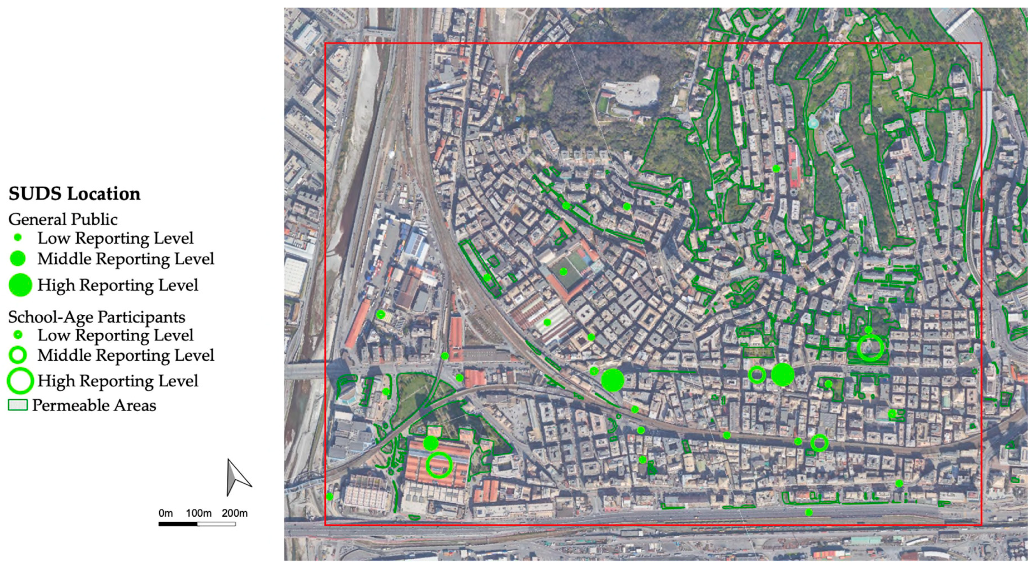
  • Engagement: The fifth and final section involves the participants in urban resilience planning. They are asked about their level of awareness regarding sustainable urban drainage systems, where they would suggest implementing them within the examined territory, and what other actions they would propose to reduce the risk of flooding.

4.4. Intergenerational Process

In order to promote an intergenerational Pmap process, the proposed approach includes the activation of various activities to be differentiated for the targeted population. In fact, the methodology also intends to give a voice to participants with limited familiarity with digital tools, as well as school-age participants from 6 to 18 years old. Although there are different activities, a basic common methodological structure has to be defined: initially, the participants’ awareness is raised on the process of key issues (flood risk, urban resilience, SUDS, and participatory governance); subsequently, data regarding the current state of the territory are collected and analyzed; finally, the participants are guided to explore, explicit, and contextualize the proposed actions.
A cycle of focus groups addressed to all those who frequent (e.g., live or work) the case study area contributes to producing tailored information on the territory of concern. During these meetings, the participants are briefed on the key issues of the process, and subsequently, they are offered a mapping activity as well as the procedure to be applied. Participants are given a paper map depicting the study area, including some cues to facilitate both the orientation and use of the map; participants are given various stationery items (pencils, pens and markers, post-its, stickers of various shapes and sizes, and transparent paper) in order to mark directly on the paper map the specific places and areas that they perceive as most exposed to the risk of flooding. During these activities, the facilitators also stimulate discussion between participants, the activation of their historical memory and the sharing of direct/indirect experiences of physical or property damages related to flood events. Perceptions regarding how often urban drainage systems (e.g., catch-basin inlets) are maintained are also probed. All the material that emerges from discussions is recorded (according to the participant agreement) by the facilitators on special paper-and-pencil recording sheets. At the end, participants should be able to locate on the map territorial resources (e.g., streets, squares, roofs) to be activated in urban regeneration and suitable for the installation of SUDS. The proposed methodology can easily collect the contributions of stakeholders and local actors less accustomed to the use of technological tools, like older people, who usually represent the historical memory of the processes.
Furthermore, the methodology aims to open the Pmap process to school-age participants: elementary school children, middle school students, and high school students. The involvement of young participants should be facilitated by schools, which act as a vector for their engagement. In relation to the grade of the school, it is possible to activate specific experiences through specific educational proposals or by means of the Transversal Skills and Orientation Pathways (namely PCTO) projects.
The proposal for engaging children attending elementary schools (ages 6–10) consists of a graphic-art expressive activity in order to explore their perceptions of the current state of the territory as well as their preferences and expectations for the future. In this case, the working group could not have direct contact with the participants but only with the participating schoolteachers; therefore, for this activity, the sensibilization and training phase on the process topics should be carried out solely with the teaching staff. Children can express themselves freely, being able to choose the most suitable drawing technique [75]. Children are asked to produce two drawings (one per sheet): in the first, they are stimulated to represent the street where they live; in the second, to draw their vision of the street in the future. No additional context should be given to ensure that children are not influenced to draw specific elements related to adult expectations [76]. The study of the perceptions and expectations offered by children gives valid indications regarding the quality of public open spaces and the identification of sustainable solutions for children.
As for middle school students, Pmap activities can take place directly at school. The methodology proposes the following activities to be developed accordingly with the common methodological structure: after a brief introduction to the themes, the students receive a paper map identifying by means of special stationery the points and areas prone to flood risk and, subsequently, the privileged places where resilience measures such as SUDS can be implemented. Illustrative materials describing the main design characteristics of SUDS and their specific installation requirements can also be provided to the students.
With high school students, it is possible to activate a more complex experience. First of all, the activities can be carried out both in the school complex and outdoors, directly in the case study area. Initially, similarly to the other school-age participants—training activities on SUDS and urban flood resilience could be held by facilitators with a technical background. Subsequently, an active survey based on Volunteered Geographic Information (VGI) can be proposed to the students that can independently explore the territory and report, directly on their personal devices, the selected variables, such as points and areas they perceive as prone to flood risk; specific places where they directly or indirectly suffered physical or property damage; clogged inlets; and well-maintained/poorly maintained green areas. To prevent participants from influencing each other, each student can only view their own report. Additionally, a specific co-planning laboratory could be organized in the school complex or in another location offered by the working group. During this co-planning laboratory, various activities can be proposed to sub-groups composed of 3 to 5 participants, such as case study analysis on paper maps, including the identification of the main urban functions; debate on the planning tools integrated with results from the VGI-based survey; analysis of the main SUDS design characteristics and their implementation; and discussion and voting of the various SUDS proposals.

4.5. Emerging Technologies and Digital Tools

It has to be noticed that there are various platforms available to perform VGI-based survey, as well as a variety of data sources that can be retrieved involving the active participation of local actors and stakeholders. Among the license-free platforms, OpenStreetMap is one of the most promising ones to create an open digital map that can be used locally or virtually [77]; some authors [78] also download data directly from social networks (e.g., Facebook and Twitter). However, there are also licensed web applications developed ad hoc, such as CitizenSensing, designed by Opach et al. [79]. Participants can upload data, along with a textual description and a photo taken directly on site, onto a single shared map, whose access and revision can be easily controlled by the process facilitators. They can also distinguish the data category with different colors; it is also possible for each reported element. The Pmap process involves handling different information layers—that can be activated or deactivated based on the scenarios to visualize, facilitating the collection of guidelines to increase the communicative effectiveness of the maps—from digitalized spatial and nonspatial. All data from the technical analysis of the current status (by means of planning tools and site surveys and participatory mapping methods (including the questionnaire, cycle of focus groups, student activities, etc.) can be georeferenced within a GIS platform, thus resulting in a PGIS map. The latter facilitates the management and analysis of spatial data together with descriptive information. The methodology suggests the use of open-source software such as QGIS and/or Google MyMaps due to its user-friendly interface, ability to easily analyze spatial data, and adaptability via plugins. QGIS can interface seamlessly with various other software, such as Microsoft Excel, which allows the management and creation of spreadsheets that can be imported directly into QGIS. In addition, it is worth noting that the use of Google MyMaps is strategic because of its ability to export all custom collaborative map data in .kml or .kmz format, which can be easily imported into the QGIS platform using the KML tools plugin.

5. Case Study

In order to test and discuss the proposed methodology, a case study was selected in Genoa (IT). Genoa is located in the north of Italy and occupies an area of 24,013-ha. The population is almost 566,410 thousand in 2022; the average population density is 24.4 ab/ha; and the population in urbanized areas is 94 ab/ha [80,81]. According to the Kopper-Geiger climate classification, Genoa belongs to the CSA Mediterranean zone, characterized by a temperate climate with hot and dry summers (total annual rainfall depth and maximum daily temperature are respectively equal to 1340 mm and 19 °C on average). Due to the complex morphology together with the high urbanization level, Genoa is prone to the occurrence of both river and pluvial flooding. In the last 30 years, the most severe events occurred on 27 September 1992, 23 September 1993, 4 October 2012, 4 November 2011, and 9–10 October 2014.
The proposed innovative methodology allows for the development of a top-down/bottom-up and intergenerational methodology for the conception of participatory maps aimed at planning and installing SUDS in urban settlements to enhance urban flood resilience. In this framework, the analysis of the case study is performed according to the following scheme:
  • Description of the selected urban district
  • Deployment of the participatory process
  • Formalization of active proposals
The urban district description includes its outlining and the perviousness of the district in terms of land use categories; the collection of climatic and flood risk data; the characterization of the main stormwater drainage network and the analysis of related municipal plans. The entire timeline of the participatory process is then in-depth described in order to support the understanding of the specific proposals for the site of concern. Finally, the active proposals are discussed to point out and generalize the main key lessons learned and support the transferability of the proposed methodology.

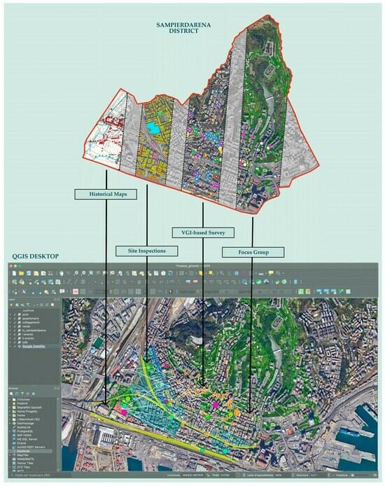
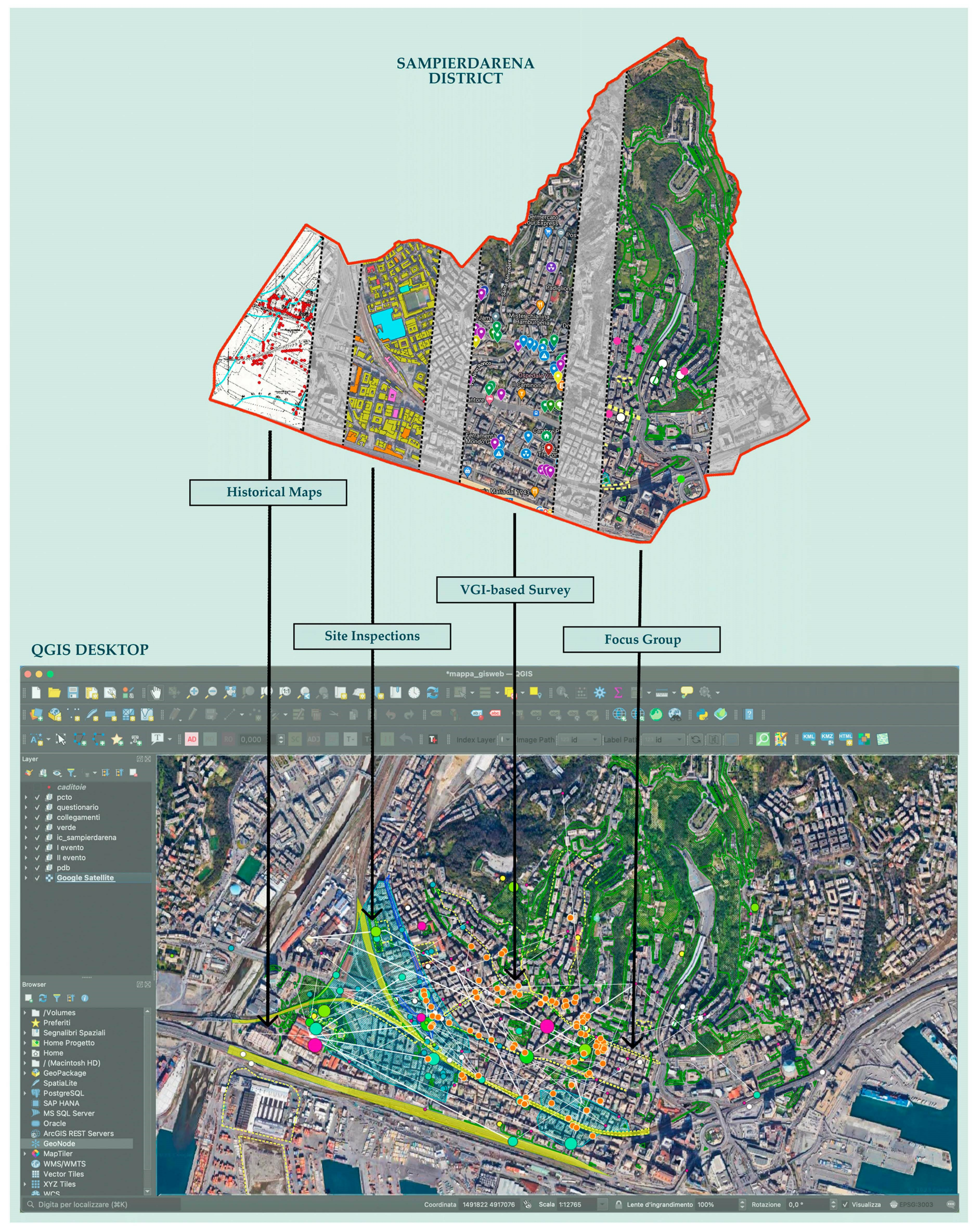
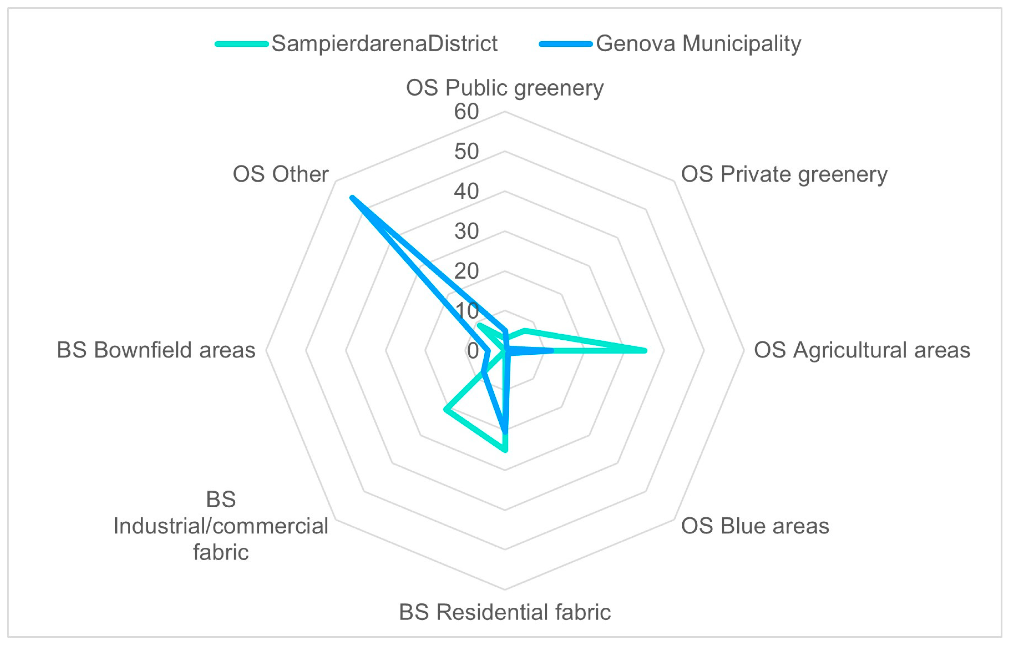
5.1. Sampierdarena District Description

The case study area has been selected within the URCA! project in agreement with the Municipality of Genoa, focusing on urban areas prone to frequent pluvial flood events and characterized by strategic activities and services. The selected case study area has an extension of about 1.8 km2, corresponding to the Sampierdarena district, as illustrated in Figure 2. The Sampierdarena district is an urban cluster located in the western part of Genoa between the commercial port and the left bank of the Polcevera river. The study area also includes three minor streams that are partially culverted: Fosso Bartolomeo, Fosso Promontorio, and Fosso Belvedere. Regarding water management, the area is mainly served by a combined sewer system partially overlapped with the naturally stream network (now culverted), and solely a marginal area is drained by a stormwater drainage system. The district presents mainly a consolidated heterogeneous urban fabric, while on the west side of the district (nearby the Polcevera River), industrial, commercial, and infrastructural functions are prevalent; furthermore, the coastline is entirely anthropic and devoted to port infrastructure. It can be noticed that zones with greater acclivity have favored in-line buildings that mimic the morphology of the basin. Across all districts, both in the residential area and the one devoted to commercial/industrial activities, green areas are extremely limited: two urban parks, a forested patch to the north, and some segments of structured urban and peri-urban green space are noteworthy. In addition, the district includes areas where the Municipal Urban Plan (PUC) [82] highlights the need for urban regeneration; in particular, referring to the analysis of the built environment reported in the PUC, such areas are classified as ‘urban voids’, ‘brownfield sites’, and ‘areas of discontinuity in the urban structure’. Indeed, the Municipality of Genoa promotes actions for urban regeneration according to natural solutions, thus enhancing urban green areas and woodland [83].
Comparing the spatial data of the Municipality of Genoa with those representing the case study area (Figure 3), it emerges that Sampierdarena district is mainly characterized by residential areas, industrial and commercial buildings, and open spaces intended for agriculture [84,85].
Therefore, the district results in a chaotic crossroads enclosed between the Polcevera Valley (along the N-S direction) and the coastline (along the W-E direction) since it is crossed by flows involving both movements towards large, specialized areas (e.g., industrial and commercial areas) and movements towards neighborhood functions and services. Indeed, the road layout has a complex configuration, including two highway tollbooths, accesses to the port and airport areas, and major urban traffic arteries. Furthermore, a regional rail park that serves as a logistics hub is also encompassed.
It has to be noticed that no SUDS are installed in the area, although in the Municipal Adaptation Plan “Genoa 2050-Action Plan for a Lighthouse City”, specific actions are foreseen to promote and diffuse these technical solutions on the territory [86]. Due to the above-mentioned characteristics, the Sampierdarena district is prone to be frequently exposed to flooding events, and the flooded areas affect the main urban traffic junctions. In this framework, the implementation of SUDS within the district may significantly contribute to mitigating urban flooding phenomena.

5.2. Participatory Process Timeline

The methodological approach developed within URCA! Project is applied to the case study of Sampierdarena, based on participatory techniques and co-design workshops to promote the role of SUDS as the key issue in a climate-resilient urban environment. In accordance with the innovative methodological approach proposed in Section 4, the working group was characterized by interdisciplinary and intersectoral team members (including civil, architectural, and environmental engineers, psychologists, sociologists, and urban planners), and the participatory process involved the 5 helixes in terms of individuals and representatives of the main urban functions in the area (Figure 4). The research promoted intergenerational participation throughout the involvement of students from three different levels of education (elementary school, middle school, and high school), thus emphasizing the importance of including needs and suggestions emerging from different age groups.
A program of site inspections was set up to collect data concerning the flood risk exposure, and the drainage inlets of the stormwater network (i.e., location and clogging phenomena); such inspections were carried out before starting the engaging phase of the participatory process in order to properly characterize the district flood resilience.
Figure 5 shows the stages of citizen engagement, from awareness-raising and mapping events to the visualization of intervention proposals and the location of solutions on the territory for reducing the flood risk. It also depicts the temporal sequence of the events, thus pointing out the simultaneous development of events designed for the general public and those specifically tailored for students.
The questionnaire (PPGIS survey), which aims at identifying and spatializing social and environmental variables related to urban flood risks, was launched from the 10 April to 1 December 2023. Its dissemination and analysis of the results served both the cognitive phase of the investigated district and the identification of actions to be implemented. The questionnaire was disseminated mainly through official social media related to the municipality and gatekeepers (e.g., consortium of local retailers, schools, etc.) and mailing lists provided by the municipality, thus involving the citizens who live in or know the district (of any age), as well as among local authority employees. In flood-resilient spatial planning, the involvement of local actors is crucial for gaining in-depth knowledge of the area, identifying the most susceptible areas to flooding, thus planning accordingly. Furthermore, engaging local actors is essential for the acceptance and support of proposed solutions. In summary, the involvement of local actors in flood-resilient spatial planning contributes to more effective and coordinated management of flood-related challenges as well as promoting the safety and well-being of local communities.
In order to engage those segments of society less familiar with digital tools, two PGIS focus groups were also organized thus applying the concept of sketch mapping in the field of urban resilience to climate change. The first PGIS focus group took place on 4 April 2023 in the public spaces managed by the municipality. The invitation to attend the focus group was disseminated with the support of the municipality, through the webpage of the questionnaire and partially through word of mouth or personalized emails. Similarly to the questionnaire, the focus groups served both for the cognitive phase of the investigated district and for the identification of actions to be implemented. During this meeting, the participants were first made aware of the key issues of the project, and they were offered a mapping activity. Participants were organized in small groups to ensure the active and operative involvement of all participants. They analyzed a paper map with an aerial view of the Sampierdarena case study, where some cues were highlighted to facilitate both familiarization with the tool and orientation. Using specific stationery (such as markers, post-its, round stickers, tracing paper, etc.), participants were encouraged to interact with the map, indicating the most critical points and areas prone to being flooded, their previous experiences related to flood events, and their knowledge of potential vulnerabilities in buildings (such as the presence of basement rooms). Each working group was guided by a facilitator, who encouraged the identification of the critical issues of the site, and by an assistant who recorded the observations and insights shared during the mapping activity. Furthermore, the facilitator stimulated the discussion between participants: the activation of their historical memory and the sharing of direct or indirect experiences related to flood events, focusing on damages to persons or property. Perceptions regarding how often urban drainage systems (i.e., catch basin inlets) are maintained were also examined. At the end of the workshop, each group illustrated their own map, thus encouraging the overall sharing of key results. The second focus group was on 1 June 2023 in the same location, with the aim of co-creating urban solutions. In this case, the participation of the identified urban functions primarily occurs through formal invitations, sharing of the initiative via the mailing list established during the previous working phases, and promotion through the communication channels of the project partners. The first part of the activity was focused on the feedback of the results from the first focus group, thus becoming the input of the second one. In the second part, SUDS, representing the solution to implement in the planning phase, were introduced by the working group. In this phase, participants had to identify and localize the most suitable SUDS for the case study area, and they were also encouraged to develop various scenarios describing potential impacts related to the specific proposals. This process aimed to foster the creation of a shared vision among the involved stakeholders. Each working group presented their ideas and proposals, and the other participants were encouraged to comment on and discuss the proposals reported on the territory map.
Elementary school students were involved in the period April-May 2023, and the activity consisted of producing two drawings depicting, respectively, their current vision of the street where they live and their aspirations in the future.
To explore a different perspective on the district’s current state, a workshop with middle school students was organized on 19 May 2023. Initially, the students attended a brief introduction dealing with the concept of resilience and SUDS, then they identified weaknesses, threats, and experiences related to flood risk in the case study area on a paper map using markers, post-its, round stickers, and tracing paper. Finally, based on the critical issues identified and the knowledge acquired during the workshop, they proposed locations suitable for SUDS installation.
The engagement of high school students occurred during the period November–December 2023; in this case, they were involved in activities using both traditional paper materials as well as digital tools since the usage of online platforms can encourage the younger generation to actively participate. The high school students attended four meetings. During the first one, the following topics were introduced: the urban resilience to floods enhanced by climate change and the factors affecting the flood occurrence (e.g., the imperviousness of urban areas). Thereafter, a site inspection across the district was carried out, and the students identified the observed critical issues that were marked on a paper map. In the second and third meetings, they participated in a series of site inspections to assess the current state of the Sampierdarena area, employing active mapping on the Google MyMaps platform that allows users to configure shared maps. Such digital tools allow participants to highlight critical areas, attach photos taken on-site, and provide a brief textual description. Subsequently, they attended an informative webinar on the urban hydrological cycle and its restoration through SUDS. The knowledge acquired from the site inspections and the webinar was applied in the fourth final meeting: a co-design workshop where students were tasked with identifying suitable locations for the installation of SUDS. The total number of participants involved in the Pmap process is equal to 282.

5.3. Analysing and Active Proposals

In this section, data collected during the above-described engaged practices were analyzed, starting from the flood risk awareness, moving to the one concerning SUDS, together with the green areas’ perception, arriving at the formalization of active proposals for SUDS implementation.
Figure 6 shows the local (dot) and diffuse (area) criticalities emerged by the overall participatory process that overlapped with the flooded areas as indicated in the Watershed Management Plan. The digital map is produced by integrating into a GIS environment the following data: information reported in the Watershed Management Plan, the critical issues (specific sites and areas) identified during the PGIS focus group, the site inspections, and mapping activities carried out with middle and high schools. The overall dataset, based on both evidence and experiences carried out by both the general public and the school-age participants, is successfully combined, encompassing all criticalities of the Sampierdarena district and providing a corresponding complete contextualization.
Results plotted in Figure 6 show a large number of local and regional criticalities extending way beyond the ones reported in the Watershed Management Plan, thus confirming the high flood risk in the area and the need for stakeholder engagement as a knowledge tool, even if it must be taken into account that objective hazard/risk could differ from subjective risk score/perception [87]. Furthermore, the analysis carried out by the general public is consistent with the one by school-age participants, thus building a common inter-generational perception and knowledge of flood risk in the area.
Following this analysis concerning flood risk perception and knowledge, the results of the third questionnaire’s section related to flood risk are discussed in order to explore the perceptions of flood damages paired with the knowledge of the best practices and measures issued by Civil Protection for flood events. The perceptions concerning flood damages are moderately high, as confirmed by only 39% of the respondents who have personally suffered flood damages or known persons who have suffered, while 59% of the respondents have not suffered damages. The perception concerning flood damages is congruent with the pluvial flood phenomenon, which is mainly due to the limited or temporarily reduced efficiency of the surface drainage and the artificial drainage network [88]. Figure 7 illustrates the level of knowledge and implementation of the different self-protection measures. The following measures were considered: the implementation of flood protection interventions (waterproofing, fixtures, bulkheads, etc.); the knowledge of the Civil Protection alert tools; being registered with one of the municipal or regional branch services for weather warnings; and the knowledge of what actions to implement in case of emergency, such as self-protection measures. Results were grouped according to three possible answers: someone in the family does it, nobody does it, and I don’t know. The results plotted in Figure 7 show a good/medium level of knowledge of measures to be taken in case of an emergency: more than 60% of participants report that they are registered with weather alert services and know what to do once the alert is issued. However, when it comes to the attitude toward implementing self-protection measures—of preventive value—participants show a low level of preparedness (only 40%). Consistency of results emerges with other studies conducted in the town of Genoa [89] where high levels of knowledge of the measures are depicted contrary to a lack of implemented measures, both individually as collectively, showing that behaviors are not related with the location nor with the corresponding risk perception. Therefore, better communication and sensibilization on the consequences of flood risks but also on the needed behavior that could be useful to increase the resilience of the local community.
Figure 8 reports the most frequented zones in the study area as indicated by the participants during the entire participation process. To guarantee map readability, the data are grouped according to three levels of importance: low, medium, and high frequented zones. Moreover, the collected data are grouped into two different classes of participants: the general public, represented by the pink dots and the school-age participants, represented by the pink hollow circles, to point out the intergenerational feature of the participatory process. The results shows a different distribution between the general public and the school-age participants; the latter are mainly identified in the western side, where the commercial areas and school districts are located. Concerning the general public, the most frequented zones result in more dispersion across the district, even if the trace of the main traffic lanes emerges as well as the relevance of the commercial area.
To strengthen the knowledge of the district (cognitive phase), the citizens’ perceptions of existing green areas were examined. Considering the results of the questionnaire, the existing green areas are inadequate for the district for 53% of the participants, 27% of whom proposed to enhance them through various actions such as increased maintenance and/or planting of new trees, as well as introducing new green areas. Such results are consistent with findings reported in the literature by Ugolini et al. [90], reporting that reporting that, according to local actors in Italy, urban green areas stimulate moderate socialization and improve limited public health. In spite of this, 50% of the participants frequent a green area of the district at least once a month, thus pointing out the relevance of green areas to improving the livability of the urban environment [91]. Referring to the direct experience of nature in urban areas, Cox et al. [92] have shown that private greenery (e.g., trees located in private yards) being widespread in the urban settlement is generally visible by many buildings with respect to public green areas that are visible solely by the facing buildings. In addition, the negative attitudes towards urban greenery due to the perception of limited public support and maintenance could drive reduced acceptance of green infrastructures (including SUDS) by citizens. Therefore, it is crucial to implement green corridors in the urban environment, thus enhancing the positive perception of greenery and the overall well-being of citizens and consequently supporting citizen SUDS acceptability.
Concerning SUDS, their knowledge and their relevance in the case study context have been explored using the questionnaire. Referring to the most common SUDS typology, the participants have indicated their corresponding level of knowledge, ranging from very low to very high. Focusing on the results illustrated in Figure 9, it emerges that about 40% of participants have a low awareness of SUDS, irrespective of the specific typology, while only 20% of participants reveal high to very high awareness of such solutions. Permeable pavements are the most well-known among the investigated ones.
The lack of knowledge about SUDS may be attributed to several factors. Firstly, there is a deficiency both related to public authorities as well as citizens in awareness about SUDS and the provided benefits in the framework of urban stormwater management. Indeed, there is inadequate training and education in schools and communities on the role of SUDS, both as technical solutions to support urban flooding mitigation and to enhance the livability of urban areas through their multiple benefits (environmental, social, etc.). Furthermore, consolidated approaches in stormwater management, deeply rooted in culture and society, limit the adoption of innovative solutions such as SUDS, and this lack of background about green solutions can impact the allocation of public resources to the detriment of their development. On the contrary, SUDS must be recognized as proactive investments, and their planning must be based on a joint dialogue between governance, society, and science [93]. The present research aims at supporting SUDS as effective mitigation/adaptation strategies by enhancing the awareness of stakeholders and local actors (the five innovation helixes) towards environmental problems, with a specific focus on urban flooding, and involving the citizens and governance in the co-design process.
Figure 10 illustrates the SUDS locations suggested by general public (green dots) and school-age participants (green hollow circles) overlapped with the existing green areas (green contour). Similarly to Figure 8, the data are grouped according to three levels of relevance: low, medium, and high frequency of selection as a possible location for SUDS installation. Referring to the intergenerational feature of the results, there is a good agreement between the locations proposed by the general public and the school-age participants. It has to be noticed that the latter also pay attention to the quality/characteristics of the existing green areas (e.g., the public park located in the eastern part of the investigated district), thus enhancing (where suitable) the ecosystem service provisioning of urban vegetation. It has to be noticed that the northern green wooded areas are situated on a sloped side and challenging to access, while the SUDS implementation is proposed mainly in the southern part of the district, where the degree of imperviousness becomes relevant, and several criticalities have been detected (Figure 6).
Figure 11 reports the correlations that are graphically illustrated as white lines with increasing thickness, between the most frequented places (pink dots) and the suggested SUDS locations (green dots). Figure 11 arises from the combination of data as previously illustrated in Figure 8 and Figure 10. Indeed, data collected from the overall participants (general public and students) are examined to point out the relationship between the most frequented zones and the potential SUDS locations. Findings concerning the connections and their frequencies confirm the significance of the commercial area (located in the western part) and the main traffic lanes along which SUDS are mainly proposed to be implemented; all zones characterized by intense vehicular and pedestrian flow are suitable for the implementation of SUDS as a solution to improve stormwater runoff management and contribute to urban flood resilience.
Figure 12 aims at providing an overview of data collected during the entire participation process implemented in a GIS environment; it shows a screenshot of the interactive map that integrates the information available in technical documents, plan, and local regulations (e.g., historical flooded areas), with the results obtained by the different actions foreseen in the participatory process (e.g., observed criticalities, suggested SUDS locations).
The georeferenced intergenerational participatory map is available online (https://prinurca.wordpress.com/genoa-patricipatory-mapping/, accessed on 1 February 2024) in English and Italian.

6. Conclusions

The present research formalizes an innovative and intergenerational approach for the development of a Pmap to support SUDS as effective mitigation/adaptation strategies in the framework of urban flood resilience. The proposed methodology is tested and discussed with reference to the case study of the Sampierdarena district in Genoa, northern Italy. Research findings include a GIS database that has been implemented starting with the digitization and georeferencing of data related to urban flood areas integrated with data collected during the activities carried out across the entire participation process (e.g., information and opinions from surveys, awareness-raising meetings, and workshops). The GIS database supports the identification of the most vulnerable urban areas prone to flood risk and those where mitigation and adaptation strategies to flood risk can be implemented. It is useful for the development of base maps to identify key features and for the development of information maps to be made available to the community. In addition, the GIS database is a tool that contributes to evaluating the effectiveness of participatory strategies together with the evolution in the planning and societal acceptance of SUDS. Therefore, the development of the GIS database, which integrates spatial and non-spatial information, can make the implementation of SUDS a key practice for environmental sustainability and flood risk reduction, while citizen participation creates a stronger link between the community and urban planning strategies. This not only improves the resilience of urban areas to flood events but also environmental awareness and social cohesion. In this sense, Pmap may be integrated into a decision support system to be developed as a guidance tool for the public administration. Moreover, the collaboration amongst stakeholders and local actors to produce a shared participatory map might be a chance to promote co-stewardship initiatives [94] at the micro or neighborhood scale, i.e., person-public-private partnerships; shared management; and monitoring and evaluating green spaces [95].
During the overall participatory processes in the Sampierdarena district, several barriers were encountered and addressed. Firstly, although the Pmap process started in the post-SarsCov2 pandemic era when no restrictions were anymore in place in Italy, some stakeholders and local actors (especially older citizens) might have been limited in their incentive to attend in-person events; indeed, it has to be taken into account that the global health emergency and the related social distancing have caused long-term changes in public behavior patterns [96]). Since the beginning, to overcome this constraint, the proposed methodology has adopted different engagement techniques, like e-participation (electronic participation), that represents an opportunity to reach those who are otherwise unreachable. Another challenge was represented by the very broad socio-cultural contest that characterizes the case study area: the district reveals heterogeneity in terms of ethnic origin. The involvement of members of ethnic minorities outside the pre-existing networks led or monitored by the municipality took place through activities in schools, thus contributing to the further involvement of their parents. In addition, future activities might strengthen social inclusiveness, such as the preparation of all materials in multiple languages, the organization of specific experiences held by native speakers, and closer collaboration with cultural aggregation centers. The above-mentioned constraints and the corresponding actions to overcome them demonstrate the high degree of adaptability and generalizability of the proposed methodology, which can be declined in relation to the site-specific characteristics (spatial, political, sociocultural, etc.) of the study area of concern. Moreover, it has to be noticed that during the implementation of the participatory process, no problems relating to so-called cultural (lack of trust, motivation, and willingness to enable participation) and resource (capacity and finances) barriers emerged [97], since the local administration has demonstrated attention to the research topic developed within the URCA! Project, thus actively participating in the Pmap process (as the first helix of innovation).
Furthermore, participation has been proven to strengthen in stakeholders and local actors a sense of belonging and responsibility to the territory and spaces over which SUDS are jointly planned and designed, contributing to their maintenance and full operational functioning over time.
In conclusion, the Pmap provides a picture of the status quo, and the criticalities at the time of the study (project-specific); therefore, the Pmap refers to the specific time when it has been implemented while cities may face social, cultural, and even climatic changes. Based on such assumptions, it clearly emerges that further research is needed to define, firstly, the usable timespan of the GIS database as well as the suitable methodology to update it. In the literature, the temporal aspect connected with participatory maps is nowadays an open issue, whereas such an awareness would constitute an advancement from a methodological point of view. On the other hand, in the proposed methodological approach, the participatory maps are processed in a GIS environment and therefore easily updated due to new emerging criticalities and actions once the updating methodology is formalized.

Author Contributions

Conceptualization, I.G., A.P., F.P. and I.S.; methodology, F.P., I.S., A.P., F.B. and M.C.L.; software, M.C.L. and F.B.; validation, I.G., A.P., M.P. and F.P.; formal analysis, I.G., A.P. and S.S.; investigation, I.S., F.B. and M.C.L.; data curation, A.P., M.C.L. and F.B.; writing—original draft preparation, F.B. and M.C.L.; writing—review and editing, I.G., A.P., F.P., F.B. and M.C.L.; supervision, I.G., A.P., S.S. and M.P.; funding acquisition, A.P. All authors have read and agreed to the published version of the manuscript.

Funding

This research was supported by the project “URCA!—Urban Resilience to Climate change: Activation of participatory mapping and decision support tools for enhancing sustainable urban drainage” (CUP D33C220004100), funded by the Italian Ministry of University and Research (MUR) in the PRIN2020 program. Fabrizio Bruno is supported by the Italian national inter-university PhD course in Sustainable Development and Climate Change (link: www.phd-sdc.it, accessed on 1 February 2024).

Institutional Review Board Statement

Not applicable.

Informed Consent Statement

Not applicable.

Data Availability Statement

Data are contained within the article.

Acknowledgments

It is intended to thank the main institutions involved within the participatory process: Municipality of Genova, the District of Genova Centro-Ovest, Emilio Salgari School, Calasanzio School, the Comprehensive School Institute Sampierdarena, Einaudi-Casaregis High School.

Conflicts of Interest

The authors declare no conflict of interest.

References

  1. The International Panel on Climate Change, AR6 Synthesis Report: Climate Change. 2023. Available online: https://www.ipcc.ch/report/sixth-assessment-report-cycle/ (accessed on 11 December 2023).
  2. United Nations Office for Disaster Risk Reduction (UNDRR), Global Assessment Report (GAR) on Disaster Risk Reduction 2023: Mapping Resilience for the Sustainable Development Goals. Available online: https://www.undrr.org/gar (accessed on 11 December 2023).
  3. Nofal, O.M.; van de Lindt, J.W. Understanding flood risk in the context of community resilience modeling for the built environment: Research needs and trends. Sustain. Resilient Infrastruct. 2020, 7, 171–187. [Google Scholar] [CrossRef]
  4. Amadei, B. A Systems Approach to Building Community Capacity and Resilience. Challenges 2020, 11, 28. [Google Scholar] [CrossRef]
  5. Ward, P.J.; Jongman, B.; Weiland, F.S.; Bouwman, A.; van Beek, R.; Bierkens, M.F.P.; Ligtvoet, W.; Winsemius, H.C. Assessing flood risk at the global scale: Model setup, results, and sensitivity. Environ. Res. Lett. 2013, 8, 044019. [Google Scholar] [CrossRef]
  6. Gimenez-Maranges, M.; Breuste, J.; Hof, A. Sustainable Drainage Systems for transitioning to sustainable urban flood management in the European Union: A review. J. Clean. Prod. 2020, 255, 120191. [Google Scholar] [CrossRef]
  7. Huber, J. Low Impact Development: A Design Manual for Urban Areas; University of Arkansas Community Design Center: Fayetteville, AR, USA, 2010; pp. 1–29. [Google Scholar]
  8. McClymont, K.; Fernandes Cunha, D.G.; Maidment, C.; Rajendran, L.; Imani, M. Towards urban resilience through Sustainable Drainage Systems: A multi-objective optimisation problem. J. Environ. Manag. 2020, 275, 111173. [Google Scholar] [CrossRef]
  9. Fagerholm, N.; García-Martín, M.; Torralba, M.; Bieling, C.; Plieninger, T. Public participation geographical information systems (PPGIS). Participatory research methods for sustainability—Toolkit #1. Research 2022, 31, 46–48. [Google Scholar] [CrossRef]
  10. Allegretti, A. Reflection from the Field: Voice in cross-cultural and transdisciplinary research. Appl. Anthropol. 2015, 35, 11–16. [Google Scholar]
  11. Geekiyanage, D.; Fernando, T.; Keraminiyage, K. Mapping Participatory Methods in the Urban Development Process: A Systematic Review and Case-Based Evidence Analysis. Sustainability 2021, 13, 8992. [Google Scholar] [CrossRef]
  12. Red Cross/Red Crescent Climate Centre: Annual Report 2007—Red Cross Red Crescent Disaster Risk Reduction and Climate Change. Available online: https://www.climatecentre.org/wp-content/uploads/Annual-Report-2007.pdf (accessed on 12 December 2023).
  13. International Fund Agricultural Development, Good Practices in Participatoy Mapping. Available online: https://www.ifad.org/documents/38714170/39144386/PM_web.pdf/7c1eda69-8205-4c31-8912-3c25d6f90055 (accessed on 12 December 2023).
  14. Reichel, C.; Frömming, U.U. Participatory Mapping of Local Disaster Risk Reduction Knowledge: An Example from Switzerland. Int. J. Disaster Risk Sci. 2014, 5, 41–54. [Google Scholar] [CrossRef]
  15. Sullivan-Wiley, K.A.; Gianotti, A.G.S.; Connors, J.P.C. Mapping vulnerabilities: Opportunities and limitations of participatory community mapping. Appl. Geogr. 2019, 105, 47–57. [Google Scholar] [CrossRef]
  16. Haworth, B.T.; Bruce, E.; Whittaker, J.; Read, R. The Good, The Bad, and the Uncertain: Contributions of Volunteered Geographic Information to Community Disaster Resilience. Front. Earth Sci. 2020, 6, 183. [Google Scholar] [CrossRef]
  17. Visconti, C. Co-production of knowledge for climate-resilient design and planning in Naples, Italy. Habitat Int. 2023, 135, 102748. [Google Scholar] [CrossRef]
  18. O’Neill, E.; Brennan, M.; Brereton, F.; Shahumyan, H. Exploring a spatial statistical approach to quantify flood risk perception using cognitive maps. Nat. Hazards 2015, 76, 1573–1601. [Google Scholar] [CrossRef]
  19. Maceda, E.A.; Gaillard, J.C.; Stasiak, E.; Le Masson, V.; Le Berre, I. Experimental use of participatory 3-dimensional models in island community-based disaster risk management. Shima Int. J. Res. Into Isl. Cult. 2009, 3, 46–58. [Google Scholar]
  20. Gaillard, J.C.; Maceda, E.A. Participatory 3-dimensional mapping for disaster risk reduction. Particip. Learn. Action 2009, 60, 109–118. [Google Scholar]
  21. Rall, E.; Hansen, R.; Pauleit, S. The added value of public participation GIS (PPGIS) for urban green infrastructure planning. Urban For. Urban Green. 2019, 40, 264–274. [Google Scholar] [CrossRef]
  22. Hartig, T. Nature experience in transactional perspective. Landsc. Urban Plan. 1993, 25, 17–36. [Google Scholar] [CrossRef]
  23. Kyttä, M.; Randrup, T.; Sunding, A.; Rossi, S.; Harsia, E.; Palomaki, J.; Kajosaari, A. Prioritizing participatory planning solutions: Developing place-based priority categories based on public participation GIS data. Landsc. Urban Plan. 2023, 239, 104868. [Google Scholar] [CrossRef]
  24. Cochrane, L.; Corbett, J. Participatory Mapping. In Handbook of Communication for Development and Social Change; Servaes, J., Ed.; Springer Nature: Berlin/Heidelberg, Germany, 2020; pp. 1–9. [Google Scholar]
  25. Denwood, T.; Huck, J.J.; Lindley, S. Participatory Mapping: A Systematic Review and Open Science Framework for Future Research. Ann. Am. Assoc. Geogr. 2022, 112, 2324–2343. [Google Scholar] [CrossRef]
  26. Brown, G.; Kyttä, M. Key issues and priorities in participatory mapping: Toward integration or increased specialization? Appl. Geogr. 2018, 95, 1–8. [Google Scholar] [CrossRef]
  27. Houessou-Dossou, E.A.Y.; Gathenya, J.M.; Njuguna, M.; Gariy, Z.A. Flood Frequency Analysis Using Participatory GIS and Rainfall Data for Two Stations in Narok Town, Kenya. Hydrology 2019, 6, 90. [Google Scholar] [CrossRef]
  28. Gebremedhin, E.T.; Basco-Carrera, L.; Jonoski, A.; Iliffe, M.; Winsemius, H. Crowdsourcing and interactive modelling for urban flood management. J Flood Risk Manag. 2020, 13, 12602. [Google Scholar] [CrossRef]
  29. See, L.S.; Calo, L.; Bannon, B.; Opdyke, A. An Open Data Approach to Mapping Urban Drainage Infrastructure in Developing Communities. Water 2020, 12, 1880. [Google Scholar] [CrossRef]
  30. Klonner, C.; Usón, T.J.; Marx, S.; Mocnik, F.B.; Höfle, B. Capturing Flood Risk Perception via Sketch Maps. ISPRS Int. J. Geo.-Inf. 2018, 7, 359. [Google Scholar] [CrossRef]
  31. Hirata, E.; Giannotti, M.A.; Larocca, A.P.C.; Quintanilha, J.A. Flooding and inundation collaborative mapping—Use of the Crowdmap/Ushahidi platform in the city of Sao Paulo, Brazil. J. Flood Risk Manag. 2015, 11, 98–109. [Google Scholar] [CrossRef]
  32. Taylor, F.E.; Millington, J.D.A.; Jacob, E.; Malamud, B.D.; Pelling, M. Messy maps: Qualitative GIS representations of resilience. Landsc. Urban Plan. 2020, 198, 103771. [Google Scholar] [CrossRef]
  33. von Kotze, A.; Holloway, A. Reducing Risk: Participatory Learning Activities for Disaster Mitigation in Southern Africa; Oxfam Publishing: Oxford, UK, 1996. [Google Scholar]
  34. Abarquez, I.; Murshed, Z. Community-Based Disaster Risk Management: Field Practictioners’ Handbook; Asian Disaster Preparedness Center (ADPC): Pathum Thani, Thailand, 2006; p. 159. [Google Scholar]
  35. Cheung, W.; Houston, D.; Schubert, J.E.; Basolo, V.; Feldman, D.; Matthew, R.; Sanders, B.F.; Karlin, B.; Goodrich, A.C.; Contreras, S.L.; et al. Integrating resident digital sketch maps with expert knowledge to assess spatial knowledge of flood risk: A case study of participatory mapping in Newport Beach, California. Appl. Geogr. 2016, 74, 56–64. [Google Scholar] [CrossRef]
  36. Brandt, K.; Graham, L.; Hawthorne, T.; Jeanty, J.; Burkholder, B.; Munisteri, C.; Visaggi, C. Integrating sketch mapping and hot spot analysis to enhance capacity for community-level flood and disaster risk management. Geogr. J. 2020, 186, 198–212. [Google Scholar] [CrossRef]
  37. O’Grady, M.J.; Evans, B.; Eigbogba, S.; Muldoon, C.; Campbell, A.G.; Brewer, P.A.; O’Hare, G.M.P. Supporting participative pre-flood risk reduction in a UNESCO biosphere. J Flood Risk Manag. 2019, 12, 12520. [Google Scholar] [CrossRef]
  38. Dixon, B.; Johns, R.A.; Fernandez, A. The role of crowdsourced data, participatory decision-making and mapping of flood related events. Appl. Geogr. 2021, 128, 102393. [Google Scholar] [CrossRef]
  39. Gottwald, S.; Laatikainen, T.E.; Kyttä, M. Exploring the usability of PPGIS among older adults: Challenges and opportunities. Int. J. Geogr. Inf. Sci. 2016, 30, 2321–2338. [Google Scholar] [CrossRef]
  40. Le Dé, L.; Gampell, A.; Loodin, N.; Cadag, J. Participation mapping 2.0: New ways for children’s participation in disaster risk reduction. Aust. Inst. Disaster Resil. 2020, 35, 34–42. [Google Scholar]
  41. Eaton-González, R.; Andrade-Sánchez, J.; Montaño-Soto, T.; Andrade-Tafoya, P.; Brito-Jaime, D.; González-Estupiñán, K.; Guía-Ramírez, A.; Rodríguez-Canseco, J.; Teon-Vega, A.; Balderas-López, S. Participatory Mapping as a Didactic and Auxiliary Tool for Learning Community Integration, Technology Transference, and Natural Resource Management. ISPRS Int. J. Geo.-Inf. 2021, 10, 206. [Google Scholar] [CrossRef]
  42. Brown, G.; Sanders, S.; Reed, P. Using public participatory mapping to inform general land use planning and zoning. Landsc. Urban Plan. 2018, 177, 64–74. [Google Scholar] [CrossRef]
  43. Cai, Y.; Amaral, M. The triple helix model and the future of innovation: A reflection on the triple helix research agenda. Triple Helix 2021, 8, 217–229. [Google Scholar] [CrossRef]
  44. Cai, Y.; Etzkowitz, H. Theorizing the Triple Helix model: Past, present, and future. Triple Helix 2020, 7, 189–226. [Google Scholar] [CrossRef]
  45. Hasche, N.; Hoglund, L.; Linton, G. Quadruple helix as a network of relationships: Creating value within a Swedish regional innovation system. J. Small Businees Entrep. 2019, 32, 523–544. [Google Scholar] [CrossRef]
  46. Carayannis, E.G.; Campbell, D.F.J. Mode 3 Knowledge Production in Quadruple Helix Innovation Systems; Springer: New York, NY, USA, 2011; pp. 1–63. [Google Scholar] [CrossRef]
  47. Pirlone, F.; Spadaro, I. The resilient city and adapting to the health emergency. TeMA J. Land Use Mobil. Environ. 2020, 305–314. [Google Scholar] [CrossRef]
  48. König, J.; Suwala, L.; Delargy, C. Helix Models of Innovation and Sustainable Development Goals. In Industry, Innovation and Infrastructure; Encyclopedia of the UN Sustainable Development Goals; Filho, L., Azul, W., Brandli, A.M., Lange Salvia, L., Wall, A.T., Eds.; Springer: Berlin, Heidelberg, 2020; pp. 1–15. [Google Scholar]
  49. Carayannis, E.G.; Campbell, D.F.J. Democracy of Climate and Climate for Democracy: The Evolution of Quadruple and Quintuple Helix Innovation Systems. J. Knowl. Econ. 2021, 12, 2050–2082. [Google Scholar] [CrossRef]
  50. Colvin, R.M.; Witt, G.B.; Lacey, J. Approaches to identifying stakeholders in environmental management: Insights from practitioners to go beyond the ‘usual suspects’. Land Use Policy 2016, 52, 266–276. [Google Scholar] [CrossRef]
  51. Zingraff-Hamed, A.; Hüesker, F.; Lupp, G.; Begg, C.; Huang, J.; Oen, A.; Vojinovic, Z.; Kuhlicke, C.; Pauleit, S. Stakeholder Mapping to Co-Create Nature-Based Solutions: Who Is on Board? Sustainability 2020, 12, 8625. [Google Scholar] [CrossRef]
  52. Spadaro, I.; Bruno, F. La partecipazione come strumento di resilienza ai rischi naturali: Una roadmap per la pianificazione urbanistica partecipativa. In Proceedings of the XXIV National Conference SIU—Italian Society of Urban Planners, Brescia, Italy, 23–24 June 2022. [Google Scholar]
  53. de Lima, A.P.M.; Rodrigues, A.F.; Latawiec, A.E.; Dib, V.; Gomes, F.D.; Maioli, V.; Pena, I.; Tubenchlak, F.; Rebelo, A.J.; Esler, K.J.; et al. Framework for Planning and Evaluation of Nature-Based Solutions for Water in Peri-Urban Areas. Sustainability 2022, 14, 7952. [Google Scholar] [CrossRef]
  54. Zhao, C.; Fu, G.; Liu, X.; Fu, F. Urban planning indicators, morphology and climate indicators: A case study for a north-south transect of Beijing, China. Build. Environ. 2011, 46, 1174–1183. [Google Scholar] [CrossRef]
  55. Weng, Q. Remote sensing of impervious surfaces in the urban areas: Requirements, methods, and trends. Remote Sens. Environ. 2012, 117, 34–49. [Google Scholar] [CrossRef]
  56. Fagerholm, N.; Raymond, C.M.; Olafsson, A.S.; Brown, G.; Rinne, T.; Hasanzadeh, K.; Broberg, H.; Kytta, M. A methodological framework for analysis of participatory mapping data in research, planning, and management, International. J. Geogr. Inf. Sci. 2021, 35, 1848–1875. [Google Scholar] [CrossRef]
  57. Naturvation Project (NATure-Based URban InnoVATION): Cities—Nature—Innovation. Available online: https://naturvation.eu/ (accessed on 20 November 2023).
  58. Growgreen Project: A Partnership for Greener Cities to Increase Livability, Sustainability and Business Opportunities. Available online: https://growgreenproject.eu/ (accessed on 1 February 2024).
  59. Urban GreenUP: Renaturing Urban Plants. Available online: https://www.urbangreenup.eu/ (accessed on 22 November 2023).
  60. UNaLab: Urban Nature Labs. Available online: https://unalab.eu/en (accessed on 22 November 2023).
  61. Linee Guida sull’adozione di Tecniche di Drenaggio Urbano Sostenibile per una Città Più Resiliente ai Cambiamenti Climatici—2018. Available online: https://www.comune.bologna.it/myportal/C_A944/api/content/download?id=6328303072e6b400994c57c0 (accessed on 10 November 2023).
  62. Linee Guida per la Progettazione dei Sistemi Urbani di Drenaggio Sostenibile nel Territorio Comunale. Available online: https://www.comune.milano.it/documents/20126/190345684/Linee+Guida+per+la+progettazione+dei+sistemi+urbani+di+drenaggio+sostenibile+nel+territorio+comunale.pdf/522c413c-1bae-53fd-c97f-257e56f9766f?t=1649409433190 (accessed on 15 November 2023).
  63. Linee Guida Volontarie per l’uso Sostenibile del Suolo per i Professionisti dell’area Tecnica—Indirizzi per la Tutela del Suolo dai Processi di Impermeabilizzazione e Dalla Perdita di Materia Organica. Available online: https://soil4life.eu/wp/wp-content/uploads/2021/02/Linee-Guida-Soil4LIFE_ebook.pdf (accessed on 15 November 2023).
  64. Linee Guida per la Gestione del Verde Urbano e Prime Indicazioni per una Pianificazione Sostenibile. Available online: https://www.mase.gov.it/sites/default/files/archivio/allegati/comitato%20verde%20pubblico/linee_guida_finale_25_maggio_17.pdf (accessed on 17 November 2023).
  65. Infrastrutture Verdi per l’Adattamento ai Cambiamenti Climatici: Strategie e Indicazioni Progettuali per la Gestione Sostenibile delle Acque Meteoriche Urbane nell’Area Mediterranea Nord-Occidentale. Available online: https://www.cittametropolitana.genova.it/sites/default/files/progetti/Linee%20guida%20-%20Infrastrutture%20verdi.pdf (accessed on 22 November 2023).
  66. Ufficio delle Pubblicazioni dell’Unione Europea, Guidelines for Co-Creation and Co-Governance of Nature-Based Solutions. Available online: https://op.europa.eu/it/publication-detail/-/publication/dd7b9f43-9a33-11ee-b164-01aa75ed71a1/language-it?WT.mc_id=Publicationdetail&WT.ria_c=null&WT.ria_f=null&WT.ria_ev=permalink&WT.URL=https%3A%2F%2Furbinat.eu%2F (accessed on 17 November 2023).
  67. Simpson, D. Thematic Brief Nature-Based Solutions; United Nations Economist Network (UNEN): Nairobi, Kenya, 2020. [Google Scholar]
  68. IUCN. Guidance for Using the IUCN Global Standard for Nature-Based Solutions. A User-Friendly Framework for the Verification, Design and Scaling up of Nature-Based Solutions, 1st ed.; IUCN: Gland, Switzerland, 2020. [Google Scholar]
  69. Seddon, N. Guidelines for Successful, Sustainable Nature-Based Solutions; Kleinman Center for Energy Policy: Philadelphia, PA, USA, 2021. [Google Scholar]
  70. European Commission, Environment, Water Framework Directive. Available online: https://environment.ec.europa.eu/topics/water/water-framework-directive_en (accessed on 11 December 2023).
  71. European Commission, Environment, Floods Directive. Available online: https://environment.ec.europa.eu/topics/water/floods_en (accessed on 11 December 2023).
  72. Holguin, N.; Mugica, A.; Ukar, O. How Is Climate Change Included in the Implementation of the European Flood Directive? Analysis of the Methodological Approaches of Different Countries. Water 2021, 13, 1490. [Google Scholar] [CrossRef]
  73. Gottwald, S.; Stedman, R.C. Preserving ones meaningful place or not? Understanding environmental stewardship behaviour in river landscapes. Landsc. Urban Plan. 2020, 198, 103778. [Google Scholar] [CrossRef]
  74. Bąkowska-Waldmann, E.; Kaczmarek, T. The Use of PPGIS: Towards Reaching a Meaningful Public Participation in Spatial Planning. ISPRS Int. J. Geo.-Inf. 2021, 10, 581. [Google Scholar] [CrossRef]
  75. Agarwal, M.K.; Sehgal, V.; Ogra, A. Creating a Child-Friendly Environment: An Interpretation of Children’s Drawings from Planned Neighbor-hood Parks of Lucknow City. Societies 2021, 11, 80. [Google Scholar] [CrossRef]
  76. van Heel, B.F.; van den Born, R.J.G.; Aarts, M.N.C. Everyday childhood nature experiences in an era of urbanisation: An analysis of Dutch children’s drawings of their favourite place to play outdoors. Child. Geogr. 2022, 21, 1–16. [Google Scholar] [CrossRef]
  77. Moghadas, M.; Rajabifard, A.; Fekete, A.; Kötter, T. A Framework for Scaling Urban Transformative Resilience through Utilizing Volunteered Geographic Information. ISPRS Int. J. Geo-Inf. 2022, 11, 114. [Google Scholar] [CrossRef]
  78. Lin, Y.; Yang, M.; Han, J.; Su, Y.; Jang, J. Quantifying Flood Water Levels Using Image-Based Volunteered Geographic Information. Remote Sens. 2020, 12, 706. [Google Scholar] [CrossRef]
  79. Opach, T.; Navarra, C.; Rød, J.K.; Neset, T.S.; Wilk, J.; Santos Cruz, S.; Joling, A. Identifying relevant volunteered geographic information about adverse weather events in Trondheim using the CitizenSensing participatory system. Urban Anal. City Sci. 2023, 50, 1806–1821. [Google Scholar] [CrossRef]
  80. Istituto Nazionale di Statistica (ISTAT). Available online: https://www.istat.it/ (accessed on 6 December 2023).
  81. ISTAT. Censimenti Permanenti, Popolazione e Abitazioni; ISTAT: Rome, Italy, 2022. [Google Scholar]
  82. Municipality of Genoa, Piano Urbanistico Comunale Vigente. Available online: https://www.comune.genova.it/servizi/puc (accessed on 17 November 2023).
  83. Municipality of Genoa. Direzione Rigenerazione Urbana—Urban Center e Centro Storico, Genova Green Strategy; Comune di Genova: Genova, Italy, 2022. [Google Scholar]
  84. Geoportale del Comune di Genova. Available online: https://mappe.comune.genova.it/MapStore2/#/viewer/34 (accessed on 9 December 2023).
  85. ISTAT. Commissioni Riunite, 9a Commissione “Agricoltura e Produzione Agroalimentare” e 13a Commissione “Territorio, Ambiente, Beni Ambientali” del Senato della Repubblica—Allegato Statistico; ISTAT: Rome, Italy, 2019. [Google Scholar]
  86. Municipality of Genoa. Economic Development Department Urban Agenda & Green Transition Office, Genoa 2050—Action Plan for a Lighthouse; Comune di Genova: Genova, Italy, 2022. [Google Scholar]
  87. Keul, A.G.; Brunner, B.; Allen, J.; Wilson, K.A.; Taszarek, M.; Price, C.; Soleiman, G.; Sharma, S.; Roy, P.; Said, A.M.; et al. Multihazard Weather Risk Perception and Preparedness in Eight Countries. Weather Clim. Soc. 2018, 10, 501–520. [Google Scholar] [CrossRef]
  88. Palla, A.; Colli, M.; Candela, A.; Aronica, G.T.; Lanza, L.G. Pluvial flooding in urban areas: The role of surface drainage efficiency. J. Flood Risk Manag. 2018, 11, S663–S676. [Google Scholar] [CrossRef]
  89. Dossche, R. Understanding the Effects of Flood Risk Perception on Individual and Collective Flood Behavior: A Mapping Exercise in Val Bisagno (Genoa). AGEI Geotema 2021, 21, 99–109. [Google Scholar]
  90. Ugolini, F.; Massetti, L.; Calaza-Martínez, P.; Cariñanos, P.; Dobbs, C.; Ostoic, S.K.; Marin, A.M.; Pearlmutter, D.; Saaroni, H.; Sauliene, I.; et al. Understanding the benefits of public urban green space: How do perceptions vary between professionals and users? Landsc. Urban Plan. 2022, 228, 104575. [Google Scholar] [CrossRef]
  91. Saraiva, M.; Roebeling, P.; Sousa, S.; Teotonio, C.; Palla, A.; Gnecco, I. Dimensions of shrinkage: Evaluating the socio-economic consequences of population decline in two medium-sized cities in Europe, using the SULD decision support tool. Environ. Plan. B Urban Anal. City Sci. 2017, 44, 1122–1144. [Google Scholar] [CrossRef]
  92. Cox, D.T.C.; Bennie, J.; Casalegno, S.; Hudson, H.L.; Anderson, K.; Gaston, K.J. Skewed contributions of individual trees to indirect nature experience. Landsc. Urban Plan. 2019, 185, 28–34. [Google Scholar] [CrossRef]
  93. Ferreira, V.; Barreira, A.P.; Loures, L.; Antunes, D.; Panagopoulos, T. Stakeholders’ Engagement on Nature-Based Solutions: A Systematic Literature Review. Sustainability 2020, 12, 640. [Google Scholar] [CrossRef]
  94. Collier, M.J.; Frantzeskaki, N.; Connop, S.; Dick, G.; Dumitru, A.; Dziubala, A.; Fletcher, A.; Georgiou, P.; Holscher, K.; Koojiman, E.; et al. An integrated process for planning, delivery, and stewardship of urban nature-based solutions: The Connecting Nature Framework. Nat. Based Solut. 2023, 3, 1000060. [Google Scholar] [CrossRef]
  95. Palla, A.; Pezzagno, M.; Spadaro, I.; Ermini, R. Participatory approach for planning urban resilience to climate change: Brescia, Genova and Matera, three compared case studies in Italy. Sustainability 2024, 16, 2170. [Google Scholar] [CrossRef]
  96. Gough, C.; Barr, C.; Lewis, L.K.; Hutchinson, C.; Maeder, A.; George, S. Older adults’ community participation, physical activity, and social interactions during and following COVID-19 restrictions in Australia: A mixed methods approach. BMC Public Health 2023, 23, 1–14. [Google Scholar] [CrossRef] [PubMed]
  97. Aranda, N.R.; De Waegemaeker, J.; Van de Weghe, N. The evolution of public participation GIS (PPGIS) barriers in spatial planning practice. Appl. Geogr. 2023, 155, 102940. [Google Scholar] [CrossRef]
Figure 1. Main phases of the methodological approach to participatory mapping.
Sustainability 16 01936 g001
Figure 2. Overview of the Sampierdarena district (Genoa, Italy) selected as case study area. The red line refers to the perimeter of the main subcatchments.
Sustainability 16 01936 g002
Figure 3. Radar graph of land use categories grouped in Open Spaces (OS) and Built Spaces (BS) for Genova Municipality and Sampierdarena District.
Sustainability 16 01936 g003
Figure 4. Involved stakeholders and local actors in the participatory process applied to the Sampierdarena case study according to the Quintuple Helix Model of Innovation.
Sustainability 16 01936 g004
Figure 5. Participatory process timeline developed in Sampierdarena district from April to December 2023.
Sustainability 16 01936 g005
Figure 6. Map of the local (dot) and diffuse (area) criticalities emerged by the overall participatory process overlapped to the flooded areas. Note that the red line refers to the analyzed map extension.
Sustainability 16 01936 g006
Figure 7. Level of knowledge and implementation of the main self-protection measures, to be implemented in case of flooding.
Sustainability 16 01936 g007
Figure 8. View of the Sampierdarena study area and locations of the most frequented zones by general public (pink dots) and school-age participants (pink hollow circles). Note that the red line refers to the analyzed map extension.
Sustainability 16 01936 g008
Figure 9. Knowledge levels on the most common Sustainable Urban Drainage Systems (SUDS).
Sustainability 16 01936 g009
Figure 10. Map of the SUDS locations suggested by general public (green dots) and school-age participants (green hollow circles) overlapped with the existing green areas (green contour). Note that the red line refers to the analyzed map extension.
Sustainability 16 01936 g010
Figure 11. Map of the correlation (white lines) between the most frequented places (pink dots) and the suggested SUDS locations (green dots). Note that the red line refers to the analyzed map extension.
Sustainability 16 01936 g011
Figure 12. The georeferenced intergenerational participatory map for planning and implementing SUDS.
Sustainability 16 01936 g012
Table 1. Most common Pmap techniques in the fields of disaster risk reduction and urban resilience.
TechniqueFunctioningStrengthsWeaknessesSources
Ephemeral
mapping
Drawing maps on the ground from memory using in loco available materialsEasy to organize and facilitate
Inexpensive
Familiar to many people
Flexible
Temporary
Limited semiology
Neither scaled nor automatically georeferenced
Difficulties in communicating results to decision makers
[12,13]
Sketch
mapping
Freehand drawings on sheet
of paper using different
colored pencils, markers, etc.
Easy to organize and facilitate
Inexpensive
Familiar to many people
Broad semiology
Flexible
Temporary
Neither scaled nor automatically georeferenced
Difficulties in communicating results to decision makers
[14,15]
VGI
mapping
Provision of data to through
location-based information
sharing technologies
Permanent
Both scaled and geo-referenced
Ease in communicating results to decision makers
Unfamiliar to many people
Software license
Limited/controlled semiology
Need for training
Not flexible
[16]
Scaled 2D mappingScaled base map on
which to draw with a variety
of stationery items
Easy to organize and facilitate
Inexpensive
Broad semiology
Flexible
Scaled
Ease in communicating results to decision makers
Temporary
Unfamiliar to many people
Not automatically georeferenced
[17,18]
P3DMParticipants build a 3D model of the case study with available materialsEasy to organize and facilitate
Inexpensive
Broad semiology
Flexibile
Both scaled and geo-referenced
Temporary
Unfamiliar to many people
Often require an external facilitator to provide the base map
Difficulties in communicating results to decision makers
[19,20]
Web-based/app-based GIS mappingProvision of data to a
web-based or app-based
GIS database
Permanent
Both scaled and geo-referenced
Ease in communicating results to decision makers
Unfamiliar to many people
Software license
Limited/controlled semiology
Need for training
Not flexible
[21]
Table 2. Participatory mapping techniques to collect nonspatial data in the contextualizing the problem(s) phase.
TechniquesMain Objective
InterviewsGathering the opinions of a selected group of people in a structured way
Questionnaires, PollsGathering the opinions of a large group of people in a structured way
World Café, Fishbowl, Focus groupsProducing thorough information from a small group of people
Expert panelsCollecting the scientific knowledge and expertise of experts in the field
Table 3. Participatory mapping techniques to include nonspatial aspects in the planning phase.
TechniquesMain Objective
Design charetteDefine common planning and development scenarios
Knowledge creationReframing the problem to be addressed and its solutions
WorkshopsCreating ideas from the integration of different perspectives
Public advisory committeesProviding regular comments and advice on the problem to be addressed
Citizen juriesUsing expert ideas to stimulate discussions and support decision-making
VisioningCreation of shared urban or landscape scenarios
Community indicators projectDevelopment of indicators/indices from people’s vision of the future
Participatory budgetingDeciding how to use public economic resources
Asset-based community developmentAssessing people’s available resources and determining appropriate action
Disclaimer/Publisher’s Note: The statements, opinions and data contained in all publications are solely those of the individual author(s) and contributor(s) and not of MDPI and/or the editor(s). MDPI and/or the editor(s) disclaim responsibility for any injury to people or property resulting from any ideas, methods, instructions or products referred to in the content.

