1. Introduction
Earthquakes, as other natural hazards, are natural phenomena occurring worldwide, whose associated consequences pose serious threats to natural and man-made environments [
1,
2,
3]. The disruptive energy of an earthquake can harm people, cause severe property damages, damage infrastructures and facilities, and cause monetary losses. As highlighted by Frolova et al. [
4], this risk is higher for urban areas, where population, services, and economic activities are concentrated. Considering the fragility of cities against seismic events, it is crucial to include measures for preventing, mitigating, and reducing risk in spatial decision-making processes [
5]. Indeed, an appropriate and high-quality planning practice helps to reduce the likelihood and the negative impacts of the event [
6,
7]. On one hand, it regulates land use in urban areas, orienting the decisions about the allocation of services and activities, and thus reducing seismic exposure through zoning high hazardous areas [
8,
9]; on the other hand, it can effectively complement the conventional mitigation measures related to retrofit interventions on vulnerable buildings, supporting the formulation of retrofitting scheme and the definition of financial and non-financial (i.e., volumetric) incentives to advance seismic reinforcement and structural refurbishments [
10,
11,
12]. From this perspective, urban planning can play a crucial role in effectively managing seismic risk [
13], acting mainly in the pre-disaster phase rather in the post-disaster relief in order to improve the responses of territories and communities to disasters [
14].
In such a complex challenge for urban planners, the definition of seismic risk reduction strategies and measures requires a comprehensive knowledge of the seismic vulnerability conditions for cities, moving from the existing building stock to the whole urban area [
15,
16]. All the aspects related to the interaction between physical elements and urban structures need to be investigated [
17]. Thus, a seismic risk assessment at an urban scale represents a significant tool allowing authorities and policy makers to evaluate seismic vulnerability scenarios, plan prevention and mitigation strategies, and define priorities of intervention [
18,
19] in order to increase the resilience of the entire city, including the historical city centers [
20]. Some scholars focus on supporting the decision-making authorities in taking actions to increase the resilience of historical city centers [
20].
Although a deep understanding of risk ensures that policy decisions are appropriate and optimal actions are taken [
21], the level of detail of the analysis should be defined in accordance with different criteria, i.e., time and costs that can be invested for the analysis, the accessibility of data, and the size of the area investigated [
16,
22].
When it comes to seismic risk assessment at an urban scale, a critical element to evaluate is the vulnerability of the building stock. Several methodologies and approaches for large-scale vulnerability assessment have been developed in the last 50 years, based on empirical, analytical, or hybrid procedures [
20,
23,
24,
25,
26,
27]. The choice between the various methods depends primarily on the number of buildings under assessment. The most accurate approaches are the analytical procedures based on structural response evaluation. They have high accuracy, but can be extremely time-consuming, requiring structural analysis of one or more numerical models representative of sample buildings. A less accurate but more practical approach is represented by the so-called indirect methods, empirical procedures identifying building categories and vulnerability classes based on typological and structural features. Within this last category, the CARTIS procedure, developed by the Italian Civil Protection Department, has been frequently applied in Italy [
28]. It is an interview-based survey method for collecting data concerning recurrent typological–structural building classes within homogeneous urban areas, which are homogeneous in terms of construction age and construction techniques and/or structural types. Technicians who have operated for years on the territory, or expert public employees in technical local administration offices, are interviewed to gather the needed information.
The main advantage of CARTIS and the empirical methods in general is that they allow for swift evaluation and can be used when details regarding the construction technique are missing. Direct methods have high accuracy, but they can be extremely time-consuming. A third type of method is represented by hybrid procedures that combine and calibrate the results obtained from mechanical/analytical procedures with post-earthquake observational damages.
When dealing with an entire city, the use of empirical methods becomes essential, because they are more suitable for large-scale analyses aimed at identifying priorities in terms of vulnerability reduction intervention and allocating resources to specific risk-prone areas [
29,
30]. Thus, simplified and rapid assessments can provide decision makers and planners with valuable information to define risk-oriented strategies and, consequently, propose more targeted norms and policy instruments to make cities more resilient and safer regarding seismic events.
This paper aims to present an expeditious methodology for assessing seismic risk at the urban scale, expanding from a single-building investigation to an urban-scale analysis. The method is, therefore, considered as an empirical method, conceived for the purpose of better informing decision making and planning processes. The novelty of the methodology is also embedded into the transposition of approaches born in the civil engineering and protection domains to the urban planning sphere, to design urban regeneration tailored strategies which address the current seismic risk conditions and are intended to boost more targeted interventions for reducing seismic vulnerability. The overall objective of this risk assessment is to provide policy makers and civil servants with a rapid and easy-to-apply tool for identifying seismic vulnerabilities at a territorial scale, looking both at the physical sensitivity of existing building stock to earthquakes and the elements exposed to risk in the city. The application of the proposed methodology allows urban planners to successfully incorporate seismic considerations in the decision-making process, designing strategies and actions oriented to mitigate and reduce risks, as well as to enhance territorial resilience and safety. Therefore, the process aims to establish priorities for risk-integrated and risk-reduction-oriented strategies of urban regeneration to boost more effective seismic improvements.
This evaluating methodology has been applied to and tested in the city of Castelfranco Emilia, in the Emilia-Romagna region, Italy. Here, the regional urban planning law no. 24/2017 [
31] is guiding municipalities towards the development of strategies mostly oriented toward the retrofitting of the existing building stock and the overall regeneration of the already-existing city, in accordance with the target of no net land take by 2050. This goal requires a targeted diagnosis of the most critical issues affecting the built environment and the whole urban system, where seismic performance is one of the most relevant in the region.
This paper is organized as follows:
Section 2 provides a detailed description of the methodology developed to perform a rapid seismic risk assessment at an urban scale, where four phases have been identified and presented;
Section 3 shows the results obtained from the application of the proposed methodology to the city of Castelfranco Emilia in the Emilia-Romagna region, Italy; and the results are then discussed in
Section 4.
Section 5 offers some key elements as conclusions.
2. Materials and Methods
2.1. Methodological Workflow
In this section, we describe the methodology developed for assessing the seismic risk at an urban scale. It was designed as an expeditious methodology because it adopts a building-scale assessment approach that is scaled-up to the urban scale in order to estimate the overall seismic risk for urban areas.
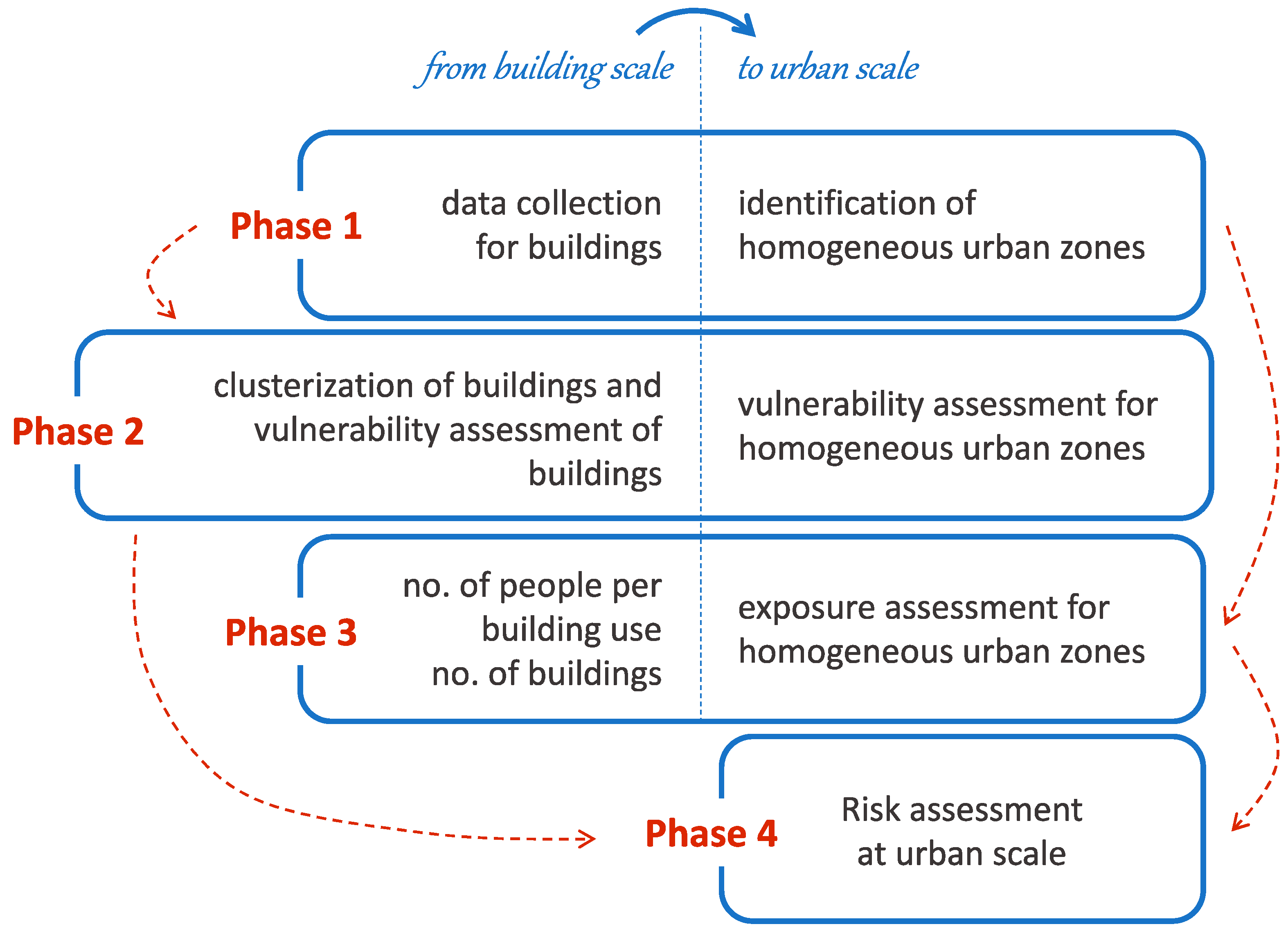
Figure 1 shows the main steps of the proposed methodological workflow and the key activities related to the building scale which allowed us to scale up to the urban scale.
As explained in
Figure 1, the methodology is composed of 4 phases. The first step aims at identifying spatial units to which similar seismic performance and behavior can be associated, according to the physical, morphological, structural, and use characteristics of the buildings located in each unit. Therefore, phase 1 is dedicated to identifying the building characteristics of the existing building stock (referring to, e.g., the building’s age, height, structural type) and the building use, and, consequently, identifying the urban zones which are homogeneous in terms of morphology, construction systems, and uses. Within these homogeneous urban zones, it would be possible to upscale data collected at the building level to the urban one for the purpose of carrying out seismic risk assessments realistically adapted to the settlement and providing reliable evaluations of its seismic performance.
In phase 2, within each homogeneous urban zone, buildings are investigated in more detail and clustered into a limited number of categories, considering their main structural type and geometric and constructive features, in order to perform rapid and approximate, but reliable, seismic vulnerability assessments of each building category. This phase is crucial because assessing the seismic vulnerability of large building stocks is a demanding and time-consuming task, due not only to the number of buildings, but also to the complexity inherent to the assessment itself, which requires carrying out surveys and tests in situ [
32]. Conversely, using expeditious methods can be a valuable alternative for studies carried out at an urban level. They are based on the principle according to which buildings with common structural characteristics, relevant for their seismic capacity, usually show uniformity in seismic behavior [
33]. Therefore, the structural response to an earthquake is assessed for sample buildings in each previously identified category, and their seismic vulnerability is attributed to similar buildings by upscaling the results and defining the average seismic behavior of homogeneous urban zones.
In phase 3, seismic exposure at the urban scale is assessed, taking into account the presence and distribution of the population within the homogeneous zones previously identified. Thus, for each homogeneous urban zone, both seismic vulnerability and exposure values are identified, and an overall seismic risk at the urban scale is estimated in phase 4.
Since the preliminary steps, data collection and management have been conducted through the Geographic Information System (GIS). Due to the spatial complexity of cities and the need to analyze the urban fabric in detail, performing a GIS spatial analysis easily allows for the elaboration of a huge number of datasets and information [
34]. The GIS environment combines geo-referenced graphical data, such as vectorized information and orthophoto maps, with building parameter information, and allows spatial variables to be stored, handled, elaborated, analyzed, and represented [
35]. In the context of a risk assessment, GIS platforms are particularly helpful in creating and properly overlapping risk-targeted maps; organizing building stock inventories; storing and crossing different data on history, architecture, urban planning, topologic, and structural characteristics with procedures for vulnerability evaluation; and integrating risk assessment procedures with mitigation options [
36].
2.2. Phase 1: Data Collection and Homogeneous Urban Zones Identification
The main task of this first phase is to collect data on the existing building stock for the purpose of gathering and systematizing all information on the building features that can influence their response to an earthquake. Data collection is, therefore, crucial to identify the homogeneous urban zones that should contain buildings and urban tissues with similar characteristics. In accordance with Conticelli et al. [
37], the identification of these spatial units is the basis for scaling up the data from the building scale to the urban scale. Several building and urban parameters can be analyzed in order to define the homogeneity of urban tissues, such as age, height, physical, geometric, and typological characteristics, as well as uses.
In the proposed methodology, two main aspects are considered for the identification of homogeneous urban zones: the construction period and the main use of buildings. The first can be considered a valuable indication for defining the building stock vulnerability according to key milestones in the introduction of earthquake-resistant design regulations and standards. Indeed, this information allows us to recognize the normative gaps buildings may show with regard to the current seismic efficiency requirements. The building age provides also preliminary information on the structural type, which is a crucial feature for assessing the building’s seismic performance. In fact, as argued by several scholars [
33,
38,
39], buildings of the same age are frequently built with similar construction techniques and materials; consequently, they show similar seismic behaviors. While the construction period helps to preliminarily distinguish whether the building may have masonry or reinforced concrete structures, the designation of the main structural type is carried out easily by observing each building for the purpose of detecting selected features and parameters that are relevant for assessing their seismic vulnerability, depending on the structural type itself. This procedure recalls the street survey procedure, proposed by some researchers as a rapid tool based on simple structural and geometrical parameters that can be observed easily from the sidewalk [
40,
41].
When it comes to the main use of buildings, this element is considered for characterizing the homogeneous urban zones in order to identify building typologies related to the use but also to primarily assess the seismic exposure of the city: In fact, building stock uses, performed activities, and offered services determine the level of attractiveness of the city and directly influence people’s presence and distribution in the territorial system. Land use zoning is commonly used for regulating urban developments, especially in Italy; therefore, data on urban use are easily obtained by consulting existing municipal plans and eventually by surveying public officials or making site visits. The main features identified are assigned to each building item through GIS software ArcMap 10.8. In the building shapefile, each polygon corresponds to a building, and the associated characteristics are collected in the Table of Attributes, allowing for their visualization, selection, and search.
2.3. Phase 2: Vulnerability Assessment
This phase is aimed at assessing to what extent an urban area is seismically vulnerable by scaling up the seismic vulnerability of the buildings located within the area. In the proposed methodology, the seismic vulnerability is evaluated by basically referring to the fragility of constructions to cope with the seismic action, and it can be understood as the overall predisposition to be damaged when an earthquake occurs [
42]. Conversely, seismic vulnerability at the urban scale is assessed here as the physical seismic sensitivity of an urban area. Sensitivity provides information about the susceptibility of cities to specific impacts, and it is influenced by specific properties of the system under consideration [
34].
Therefore, to assess the seismic vulnerability of each homogeneous urban zone, the proposed methodology firstly identifies sample buildings selected within the area, which represents the main building typologies of its entire building stock. Secondly, it assigns the vulnerability values of the sample buildings to all the buildings within the zone by referring to the building characteristics detected in the previous phase. This assessment is based on the assumption that a strict correlation exists between the construction period, structural type, and possible damage mechanisms that may be activated when an earthquake occurs [
43]. Therefore, this methodology adopts the approach of defining building typologies, which is considered highly useful in assessing seismic risk [
35,
44]. Consequently, existing buildings are clustered into a limited number of categories, and sample buildings are used to perform rapid and approximate, but reliable, physical seismic vulnerability assessments to be referred to larger portions of urban areas.
2.3.1. Vulnerability at Building Scale
Vulnerability assessment at the building scale is an important step which is based on the identification of the building structural type carried out in phase 1. Indeed, building structures present different seismic vulnerability levels, depending firstly on structural types and secondly on specific geometric features and construction techniques. Thus, the entire building stock is clustered into several typological categories, and within them, sample buildings are identified in order to cover all the main cases assumed by the evaluation parameters required for the expeditious models.
The seismic assessment of existing buildings is carried out by applying two different expeditious methods as proposed by Predari and Stefanini [
45]: one for masonry structures and the other one for reinforced concrete structures. Both methods are implemented on spreadsheets, which have a similar configuration. Detailed information on the vulnerability assessment models is available in the cited study.
The main relevant output is an index of structural response, which describes the building’s vulnerability to a seismic event, independently from hazard and exposure. This index is formulated based on a numerical value from 0 to 1, where the higher the value, the better the seismic capacity, and it is reported as a class from I to VI, where I is the worst and VI the best. Although the aforementioned methods express the results through six classes, in the proposed methodology, the VI class is sub-divided into three ranges to differentiate the buildings with better seismic performance within the homogeneous urban zones. Thus, we report the results through eight vulnerability classes, namely, from H, higher vulnerability, to A, lower vulnerability.
All the existing buildings that present similar typological, geometrical, and structural characteristics of a previously assessed sample building are associated with the same vulnerability class as the sample building.
2.3.2. Vulnerability at Urban Scale
Once seismic vulnerability classes have been assigned to the entire building stock, these data are upscaled to each previously identified homogeneous urban zone. The upscaling process is based on considering the quantity of buildings classified into the different vulnerability classes within each zone. Indeed, the methodology does not aim at obtaining the vulnerability class of each building, but rather the distribution of these classes within the homogeneous urban zones. As shown in
Table 1, the vulnerability classes of the buildings in the urban area were grouped into four categories in order to provide a qualitative indicator of the vulnerability degrees for the homogeneous urban zones. Classes were assigned by considering the prevalence of vulnerability classes of buildings in each homogeneous urban zone, from low to very high.
2.4. Phase 3: Exposure Assessment
Exposure (E) to seismic risk refers to all elements exposed to the earthquake hazard, in terms of people (i.e., number of inhabitants) and assets (i.e., number of buildings).
Notably, in our methodology, E is calculated through a weighted average which considers the number of buildings and people in each homogeneous urban zone, according to the following equation derived from Bacci M. and Di Marco M. [
46]:
While the number of buildings is easily measurable, the presence of people is determined in relation to the different activities hosted in the buildings. Even though the identification of homogeneous urban zones previously undertaken was also based on land uses, these areas are not always completely homogeneous, especially in cases of mixed-use areas. Here, according to the data collected in phase 1, urban uses (residential, commercial, industrial, public services) identified in each zone are assessed by considering the different activities hosted in buildings, which in turn determine the presence of people differently. At the same time, the number of people exposed is estimated, depending on the use. The number of people in residential use is detected by considering the number of inhabitants geo-referenced according to their residencies. That in education is estimated by the number of students enrolled in each school, while the number of people involved in public services is estimated according to the number of employees.
In each homogeneous urban zone, urban uses are assessed in terms of generated exposition, and the sum of the expositions generated by them defines its overall E value (E
hz). In order to consider the variability of the homogeneous urban zones in terms of territorial extension, this value is divided by the surface area. The formula used for calculating the final exposition is the following:
where:
Ehz = overall exposition of each homogeneous urban zone;
Efsi = exposition of the i-th urban use calculated with Equation (1);
n = number of urban uses present in the given homogeneous urban zone, going from 1 to a maximum of 4, depending on the present urban use;
Shz = surface of each homogeneous urban zone.
Lastly, the obtained seismic Ehz values are equally divided into four seismic exposure classes, from low to very high, to be assigned to the homogeneous urban zones.
2.5. Phase 4: Risk Assessment
Risk is generally assessed as a function of hazard, vulnerability, and exposure [
29,
47,
48]. This is valid also when it comes to seismic risk, even though, as noted by Maragno et al. [
34], from an urban planning perspective, there is no control on the seismic hazard itself. This is defined as the probability that an earthquake will occur, while vulnerability and exposure are factors that can be locally modified to some extent. In other terms, since the final aim of this study is to address vulnerability and exposure though urban strategies that influence the characteristics of the built environment and the way it is used, hazard can be considered predominantly as a context variable that can be kept apart from the risk calculation.
Therefore, seismic risk assessment in this study is carried out by combining vulnerability and exposure values calculated for each homogeneous urban zone. Since both vulnerability and exposure are classified into four classes, similarly risk is expressed through a qualitative classification, from low to very high, as shown in
Table 2. Consequently, a specific seismic risk class is assigned to each homogeneous urban zone.
3. Results: The Application to an Italian Case Study
3.1. The Italian Context
Italy is one of the European countries most exposed to seismic risk [
49]. It is characterized by a high seismic hazard, concentrated in the central-southern part of the peninsula along the Apennine ridge, the location of the convergence of the African and Eurasian plates [
50]; furthermore, a large portion of the buildings was designed between the 1960s and 1970s, a period when only a small part of the Italian territory was considered to be seismically at risk for structural design purposes [
51]. Indeed, through a series of principles and rules established in building codes, the resulting construction ought to implicitly satisfy some structural reliability requirements that should ensure its resistance to seismic forces. As discussed in [
52], seismic regulatory codes in Italy have undergone a significant number of changes in the last century. At the national level, the most update norm in terms of standards for construction is the Technical Standards for Construction 2018 [
53], with its ministerial circular, which prescribes a minimum safety level against seismic force, both for new buildings and retrofitting interventions on existing constructions.
As affirmed by [
54], the frequency of damages and losses due to earthquakes has significantly increased over recent decades in Italy, pushing the Italian government to approve specific incentives for householders interested in seismically retrofitting interventions for their properties. The Legislative Decree no. 63/2013 [
55] gives access to economic incentives to be used for reducing seismic risk in existing buildings, an initiative called “Sisma bonus”: its first version established that a fiscal detraction from 50% to 85% of the costs of interventions for improving seismic safety of constructions would have been reimbursed by the Italian state. The higher the effectiveness of properly designed seismic reinforcement solutions, the higher the tax deduction guaranteed by the law [
56,
57]. This norm was updated in 2020 with the Legislative Decree no. 34/2020 [
58], which has raised the amount of discount to 110%, introducing the so-called “Super bonus” as a new and strong incentive for structural refurbishments [
57].
Beyond the economic instruments available for addressing seismic vulnerability at the building scale, it is largely acknowledged that urban planning policies and regulations are important tools for reducing the vulnerability of the built environment as whole, increasing the resilience and safety of cities [
3,
59,
60]. Indeed, urban planning has the power to orient other types of incentives, such as additional volumetric rights, that can boost building retrofitting. In Italy, regions are competent authorities for urban planning, and are delegated for developing proper planning laws in compliance with the general framework set at the national level. Consequently, regional laws are the main references for urban and spatial planning.
3.2. The Emilia-Romagna Urban Planning Framework
In 2017, the Emilia-Romagna region adopted a new regulatory framework in the field of urban planning: the Regional Law (RL) no. 24/2017 [
31], which is one of the most advanced frameworks in Italy. Indeed, the RL 24/2017 intends to drastically limit land take by introducing a land take target equal to 3% of the urbanized territory in 2017 that can be taken by 2050. The RL requires all municipalities in the region to adopt and approve new General Urban Plans (Piano Urbanistico Generale—PUG) in order to innovate their land use planning according to the new law and ban any new urban development that does not respect the target. Consequently, any forecast of future urban growth in Emilia-Romagna must necessarily converge towards urban regeneration and densification strategies by increasing existing volumes or reusing abandoned or degraded areas or empty lots within urban boundaries, and, at the same time, increasing the performance of the existing building stock. Concerning this last goal, the RL explicitly pushes towards increasing the energy and seismic performance of existing buildings, asking PUG to assign volumetric incentives to support building retrofitting depending on the real needs of the urban contexts. Consequently, municipalities in Emilia-Romagna are in the process of reorganizing their planning instruments starting from more detailed analysis of the built-up areas by investigating also their seismic performance, as requested by the law. Due to the provisions of the RL, identifying and adopting expeditious methods to assess seismic risk at the urban scale is a concrete need which has never been conceived before.
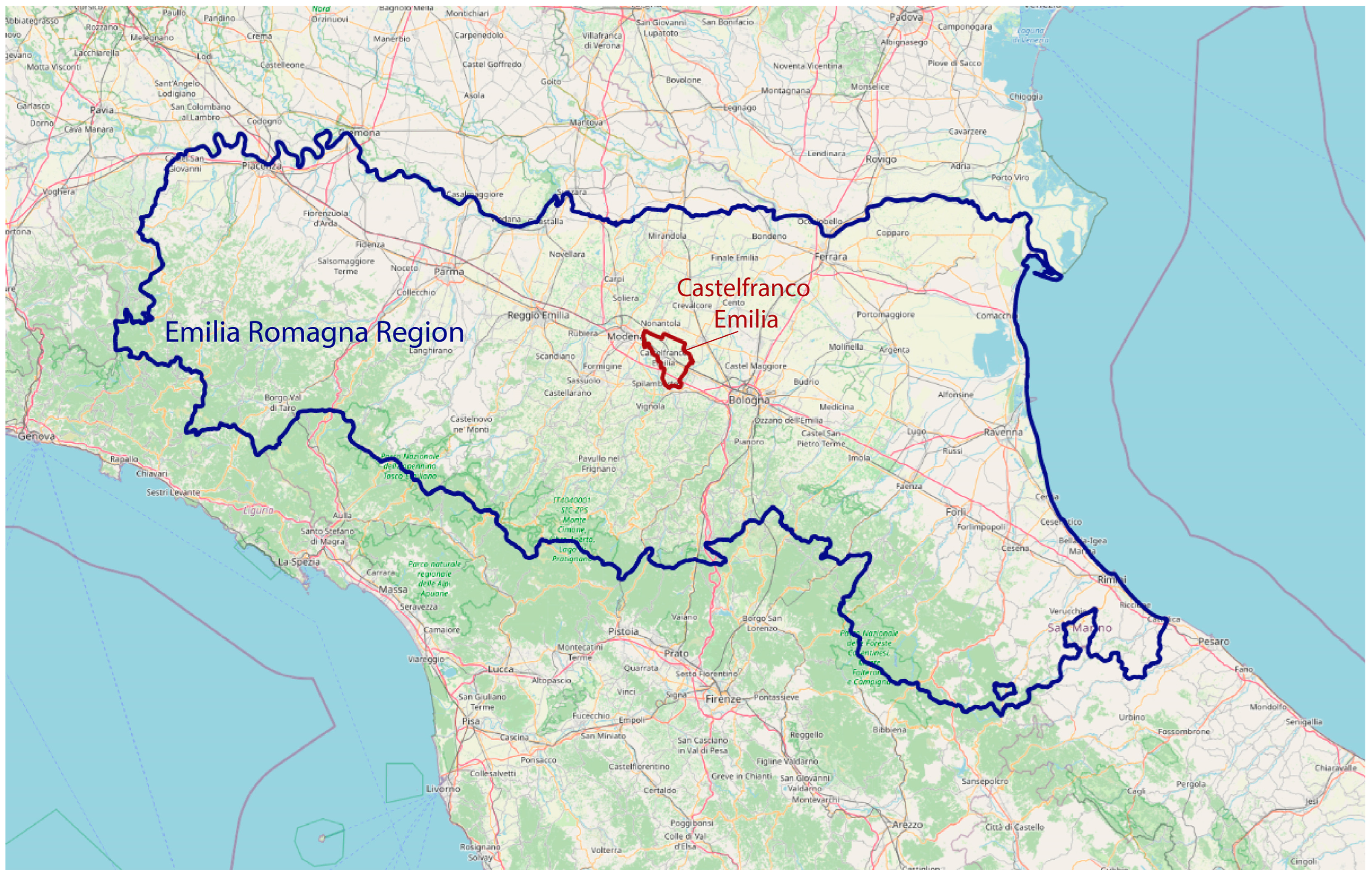
3.3. The City of Castelfranco Emilia
Castelfranco Emilia is an Italian city in the Emilia-Romagna region, located between the cities of Bologna and Modena (
Figure 2). The area of the city is 102.51 km
2, which comprises the main town and four hamlets (i.e., Gaggio, Manzolino, Piumazzo, Cavazzona). The municipality counts around 33,000 inhabitants, with a population density of 323.68 inhabitants/km
2.
The city of Castelfranco Emilia is currently in the process of designing a new urban plan according to the new regional law. During this process, a detailed analysis of the characteristics of the building stock has been performed, and the town has been the object of several studies aimed at analyzing not only its seismic vulnerability, but also its energy performance. Therefore, the preliminary tasks are in line with those developed by Conticelli et al. [
37], aimed at assessing the energy efficiency at the urban scale in the same urban context. This article presents the results of the seismic risk assessment methodology performed for the urban area of the main urban center and the hamlets, while the maps in the following sub-sections show the results for the main town only.
3.4. Phase 1: Data Collection and Identification of Homogeneous Urban Zones
In order to perform the seismic risk assessment, as explained in
Section 2, data regarding the existing building stock were collected, looking at geometrical, typological, and structural features influencing the buildings’ responses to seismic events.
The following sub-sections report the main results on the analyzed features for the building stock of the main urban center.
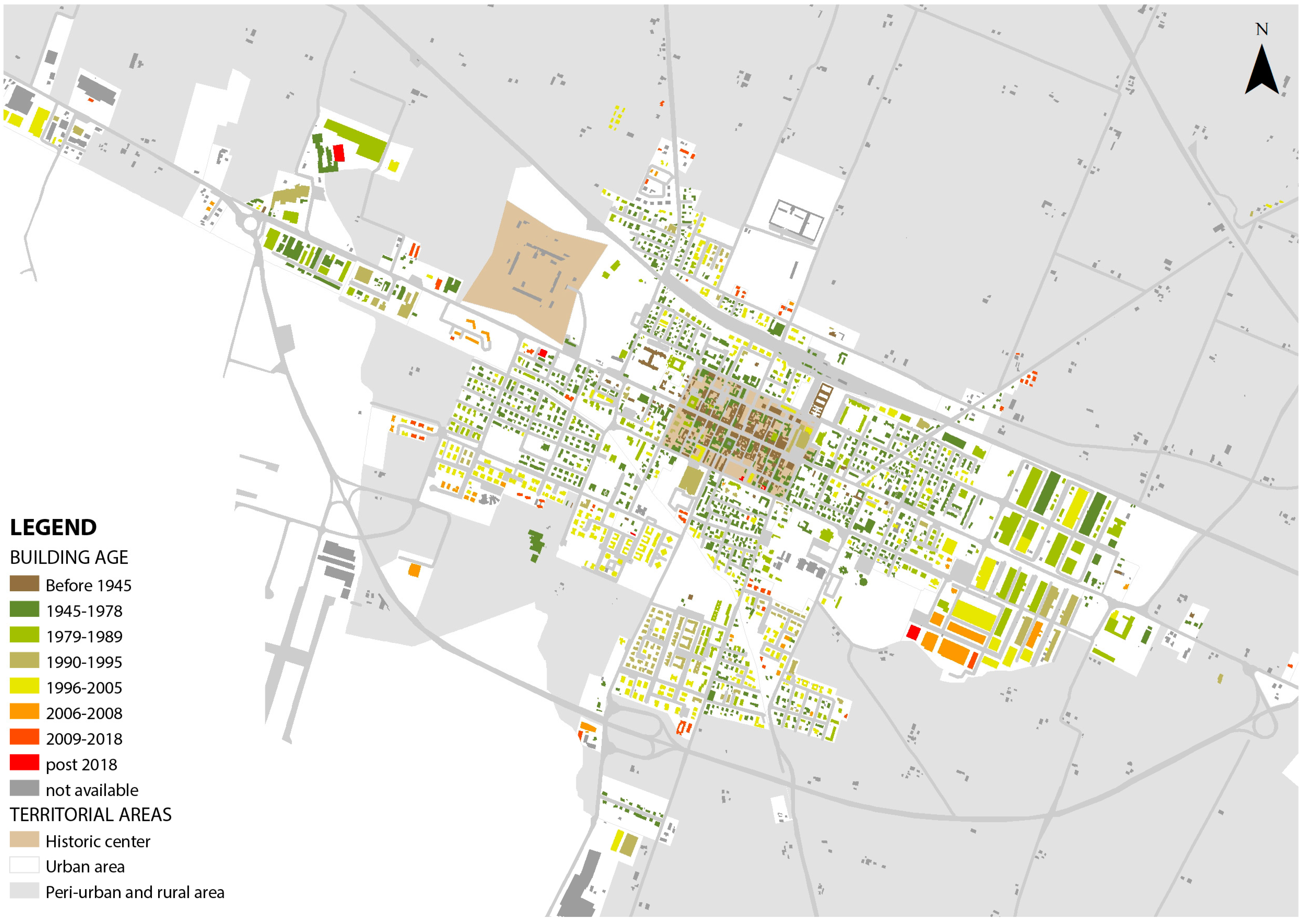
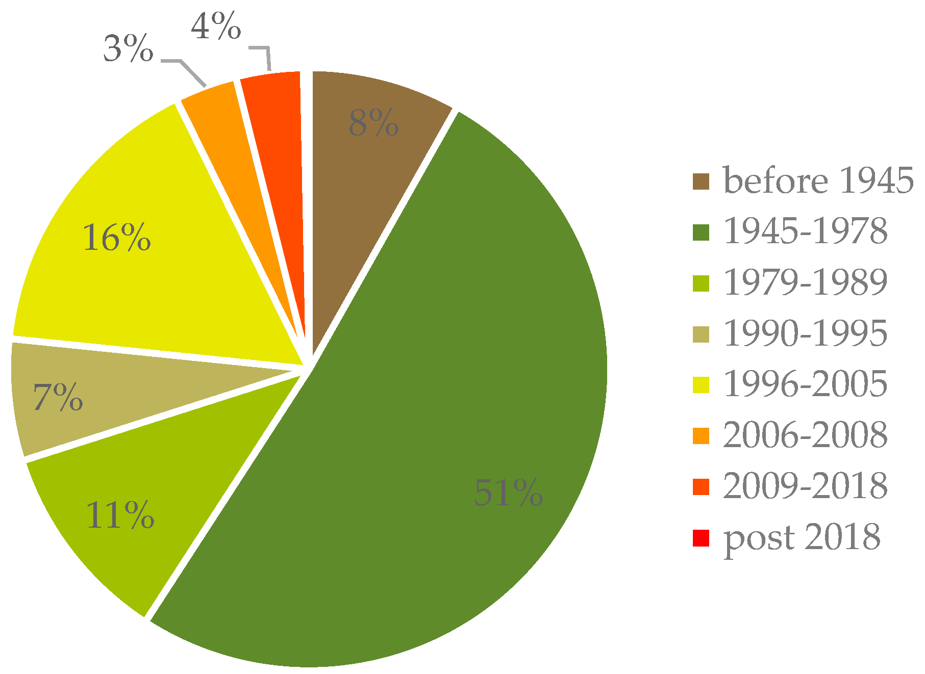
3.4.1. Building Age
The building age is represented by age classes, considering the most significant regulations and laws that have increased the seismic efficiency performance required for new buildings, according to
Table 3.
Starting from two georeferenced databases provided by the Municipality (see [
37]), the building age classes considered were as follows:
Before 1945;
1945–1978;
1979–1989;
1990–1995;
1996–2005;
2006–2008;
2009–2018;
Post-2018.
Figure 3 reports the percentage distribution of building age classes in the whole urban area, while
Figure 4 shows maps of buildings according to their age classes for the main town.
3.4.2. Building Height
For the building height, there is a strong prevalence of low-rise buildings with two and three storeys (67%), typical of the Italian towns and villages. However, there are also a number of four-storey buildings (12%) and one-storey buildings (16%), while there are very few buildings with five storeys or more (4%).
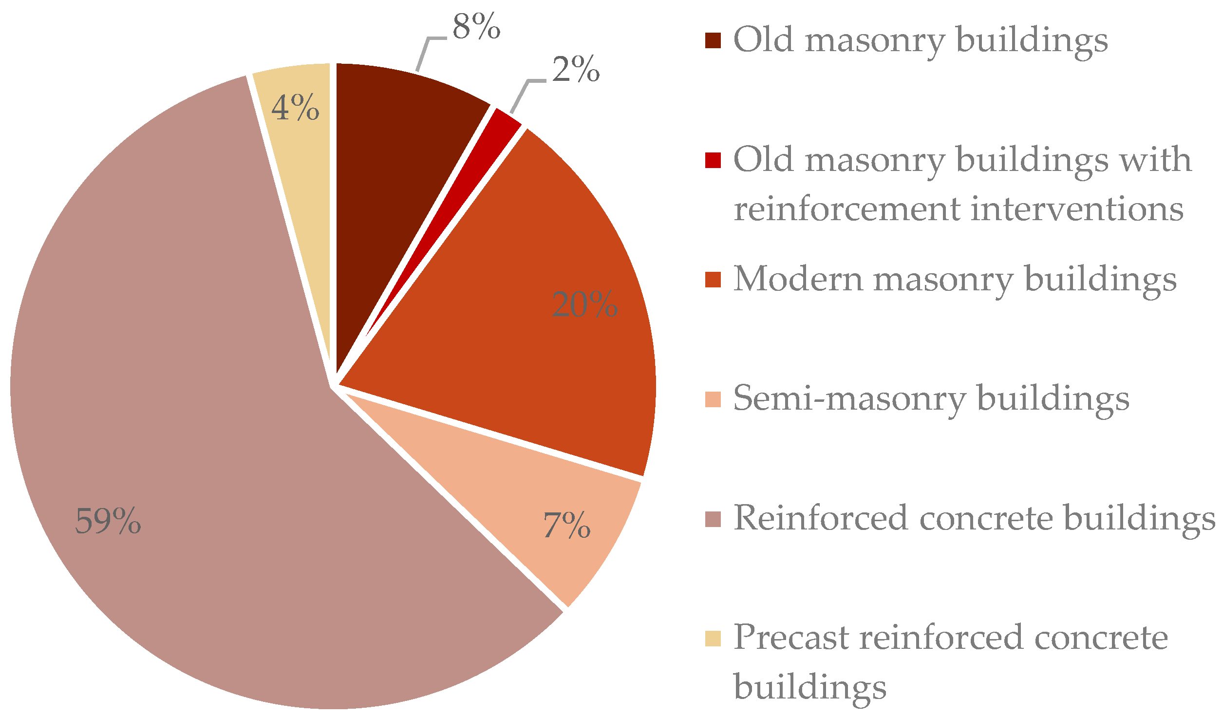
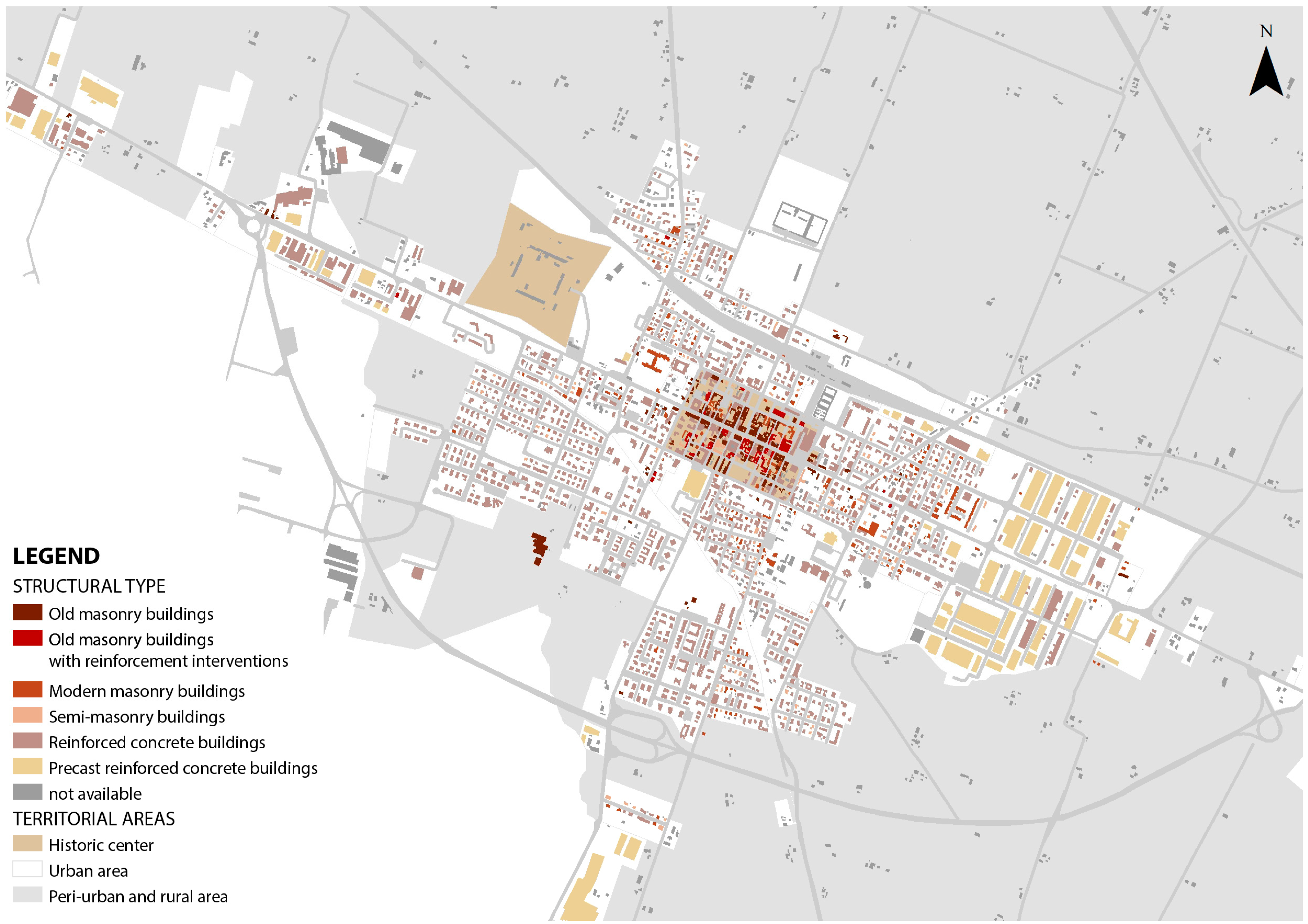
3.4.3. Building Structural Types
The structural type is assigned to the whole building stock through an empirical approached based on rapid visual screening to identify structural and constructive features. Even though two main structural types, namely, masonry and reinforced concrete, are considered as main references for performing rapid vulnerability assessments, the observation of the building features highlights the need to cluster the entire stock into six categories, as listed in
Table 4.
Referring to the different categories,
Figure 5 reports the percentage distribution for the main town and the four hamlets, while
Figure 6 shows the spatial distribution in the main town.
3.4.4. Building Uses
Regarding the buildings’ uses, residential use is predominant, with around 87% of buildings dedicated to this use; other relevant uses are public service (6% of buildings) industrial (4% of buildings), and commercial uses (only 2%).
3.4.5. The Homogenous Urban Zones
According to the data on the building stock features previously described, the homogeneous urban zones were identified as follows [
37]:
Historical built-up area;
First residential development;
Second residential development;
Third residential development;
Historic industrial development;
New industrial development;
School sports hub;
Healthcare center hub;
Railway hub.
As explained in
Section 2, the typology of homogeneous urban zones was assigned by referring to the ages and the main uses of the buildings. For the residential asset, three different developments were identified as representative of a variety of construction periods: the first one comprises buildings constructed between 1945 and 1978, the second one includes buildings constructed in the period of 1979–1995, and the third one consists of constructions built after 1995.
The main town was divided into 29 homogeneous urban zones, as represented in
Figure 7. Gaggio, Manzolino, Piumazzo, and Cavazzona were divided into 5, 7, 7, and 5 homogeneous urban zones, respectively.
As explained in
Section 2, identifying territorial units which contain buildings with homogeneous characteristics is necessary in order to perform seismic risk assessments at the urban scale for the purpose of correctly upscaling the information gathered during the analysis, from the building to the urban level.
3.5. Phase 2: Vulnerability Assessment
The following sub-sections report the results of the vulnerability assessment, firstly at the building scale and secondly at the urban scale, obtained by applying the methodology as explained in
Section 2. The vulnerability assessments were performed in all the homogeneous urban zones, except for the railway hub, as the necessary information on the buildings within it was not available.
3.5.1. Vulnerability at Building Scale
Referring to data collected for the building stock in phase 1, existing buildings were clustered into several categories according to their structural type, the age of construction, and the height. Within each category, sample buildings were selected for the vulnerability assessments, making sure the selection covered all the structural types and related characteristics identified in
Table 4. According to the structural characteristics, geometric features, and construction techniques, the input parameters required by the expeditious models were detected. The evaluation models thus returned an index of structural response for the sample buildings, which was then projected to all the buildings with similar characteristics. Although the vulnerability assessment at the building scale was conducted through the application of expeditious evaluation models based on the identification of typological categories and sample buildings, the results are consistent in terms of providing a reliable overview of the vulnerabilities and seismic performances of the existing building stock.
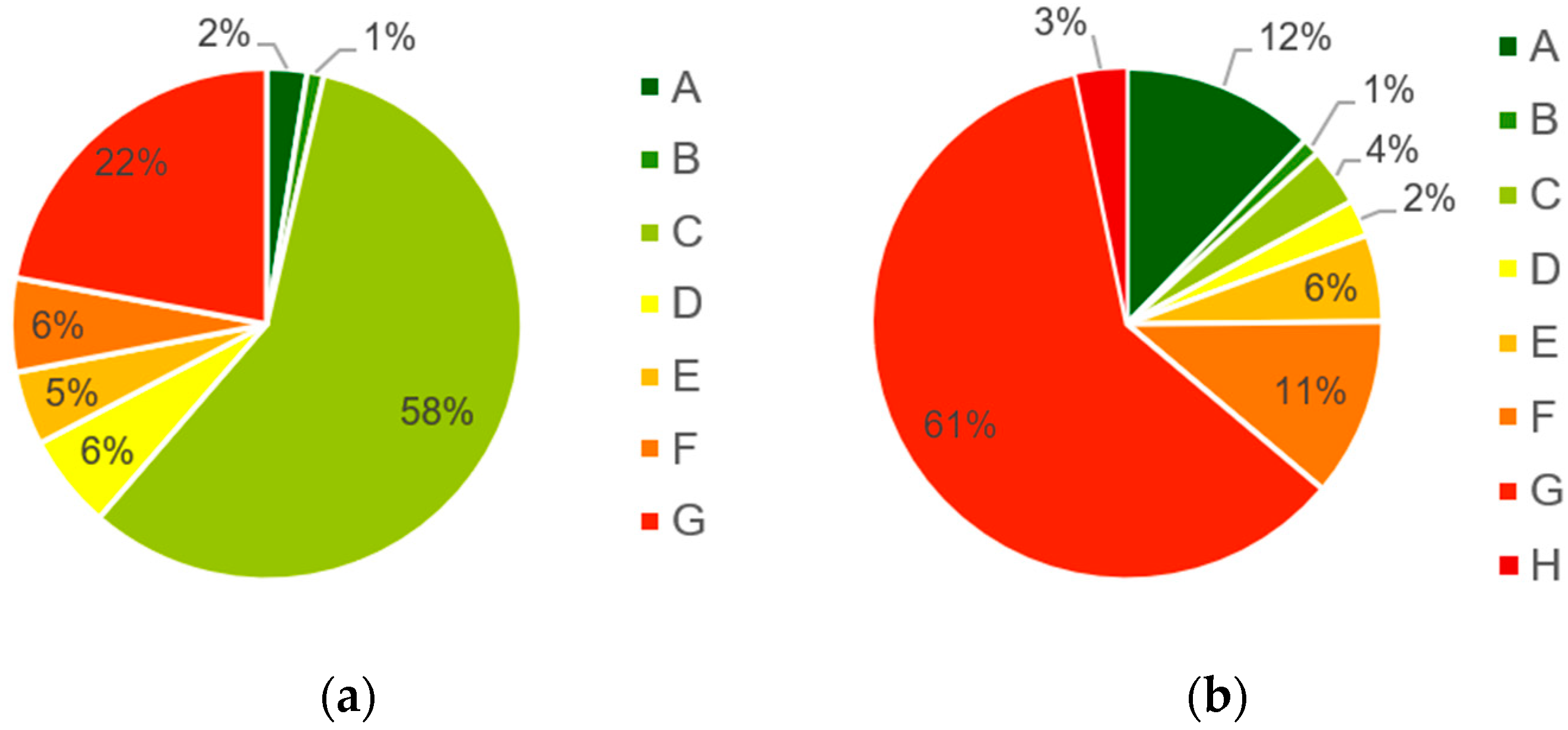
Figure 8 shows the percentage distribution resulting from the application of the expeditious models for the main town and the four hamlets, while
Figure 9 shows the maps of the seismic vulnerability classes attributed to all buildings in the main town.
Considering masonry and semi-masonry buildings, 58% presented a medium vulnerability, belonging to class C. There was also a high percentage of constructions (22%) to which a class G was assigned, mainly the building aggregates of the historic center. Worse conditions were observed for reinforced concrete buildings: there was a clear imbalance towards high vulnerability values, with a prevalence of classes F and G, around the 72% of the buildings surveyed. Their distribution over the urban area reveals that these are frequently located in the first and second residential peripheries, and they mostly date back to the second half of the 20th century, between the 1950s and the 1980s. A very high sensitivity toward seismic events also characterizes the industrial constructions realized in precast reinforced concrete. Few existing buildings are attributed to a medium vulnerability class, and these are punctually distributed in the most peripheral areas of the city. Finally, a small percentage of buildings (13) have guaranteed good seismic performance, and these were recently designed and built according to anti-seismic technical standards.
3.5.2. Vulnerability at Urban Scale
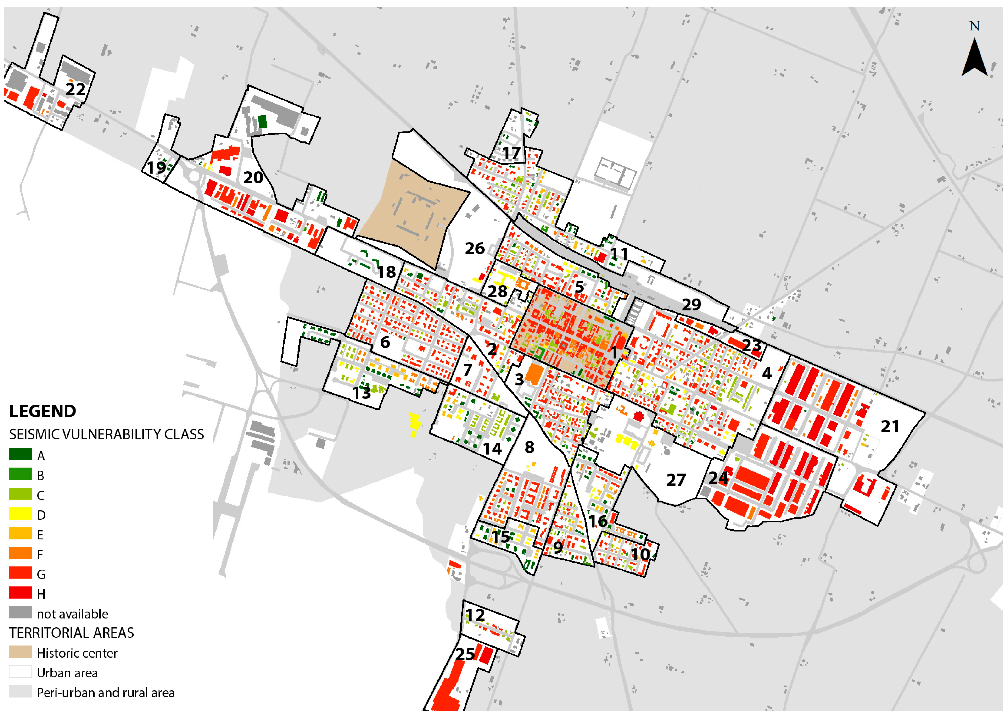
The vulnerability values obtained at the building scale were upscaled to the urban scale to indicate the degree of seismic vulnerability for each homogeneous urban zone, referring to the prevalence of vulnerability classes, as explained in
Table 1.
Figure 10 shows the maps of the homogeneous urban areas in the main town according to their seismic vulnerability classes.
Out of 28 homogenous urban zones in the main town, 17 are highly vulnerable to seismic risk, 7 are in the medium seismic vulnerability class, and 4 are in the low class. It is interesting to notice where the most vulnerable areas of the city are located: the city center and the residential peripheries are classified as highly vulnerable, in accordance with a non-recent existing building stock, while the low-vulnerability areas are located within the zones of new urban expansion, where the building stock is more recent, as it complies with earthquake-resistant regulations. Similar results were found for the hamlets: the historic centers and the oldest residential peripheries are highly vulnerable to seismic risk, as well the historic industrial sites, while the newest residential and industrial areas are classified as medium- or low-vulnerability.
3.6. Phase 3: Exposure Assessment
As explained in
Section 2, for evaluating E to seismic risk, a weighted average between the number of buildings and people in each homogeneous urban zone was applied (see Equation (1)).
While the number of buildings is easily known from the analysis of building uses in phase 1, the presence of people was estimated by combining different methods. The inhabitants’ distribution was provided by the municipality, in terms of the number of inhabitants per residential building, geo-referenced in GIS. In addition, the number of students in each school was gathered, as well as the number of employees in all the public offices, in the municipal library, and in healthcare facilities. Lastly, the Chamber of Commerce of the Province of Modena provided data on active enterprises and employees, according to economic sector and enterprise category, in the whole municipality. An average number of employees/m2 per commercial and productive building was estimated. By consulting the current municipal urban plans and the maps of the buildings’ stock uses, the total sqm of buildings per economic sector was calculated and compared to the total number of employees. Multiplying this value for the surface area of each commercial or productive construction returned the estimated number of workers inside it. Clearly, this is a simplified assessment, resulting in a tentative and approximate, yet still reliable, estimate of the daily occupancy in these buildings. Despite some necessary simplifications, these data provide some useful insights for an easy and rapid assessment of the number of people exposed to seismic risk.
By applying Equation (1), the seismic E values were calculated for each homogeneous urban zone according to the different urban uses within it; then, an overall E
ha value was estimated using Equation (2). As explained in
Section 2, the seismic E
ha values were equally divided into four classes and attributed to the homogeneous urban zones.
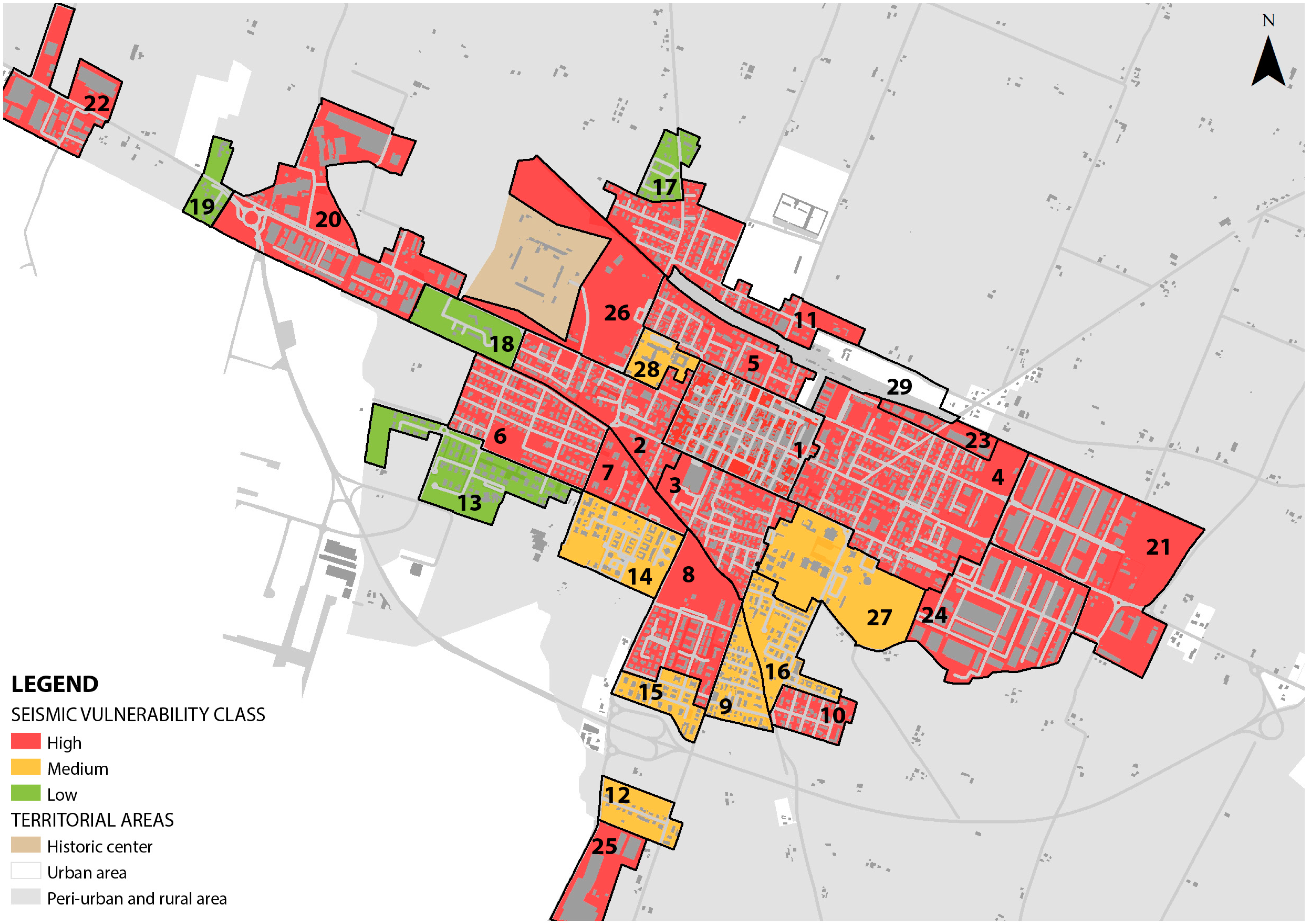
Figure 11 shows the maps of the homogeneous urban zones in the main town, according to their exposure classes.
Out of 28 homogeneous urban zones in the main town, 1 was classified as very highly exposed to seismic risk, 12 as high, 7 as medium, and 9 as low. Beyond numbers, it was visible how the exposure value was higher in the city center and in the surrounding areas, while it tended to degree in the peripheries, which are characterized by a lower population and building density. For the hamlets, the results varied significantly. The homogeneous urban zones in Gaggio had medium exposure to seismic risk, except for the small historic center, which was classified as low-exposure. In Manzolino, Piumazzo, and Cavazzona, the historic centers and the residential zones were found to have high or medium exposure to seismic risk, while the industrial sites were in a low exposure class, similarly to the main town, given the low number of inhabitants there.
3.7. Phase 4: Risk Evaluation
As explained in
Section 2, the last phase is the overall seismic risk evaluation for each homogeneous urban zone.
The hazard factor was assessed by considering the Seismic Classification Map of the Italian territory, realized by the National Institute of Geophysics and Volcanology in 2004 [
62]. According to this map, the city of Castelfranco Emilia is classified as having a low-to-medium level of hazard, corresponding to the third class, and the whole municipal territory is characterized by an equal level of hazardousness. Therefore, the hazardousness does not influence the evaluation of the overall seismic risk at an urban scale, which is determined according to the vulnerability and exposure classes previously assigned to the homogeneous urban zones, as reported in
Table 2.
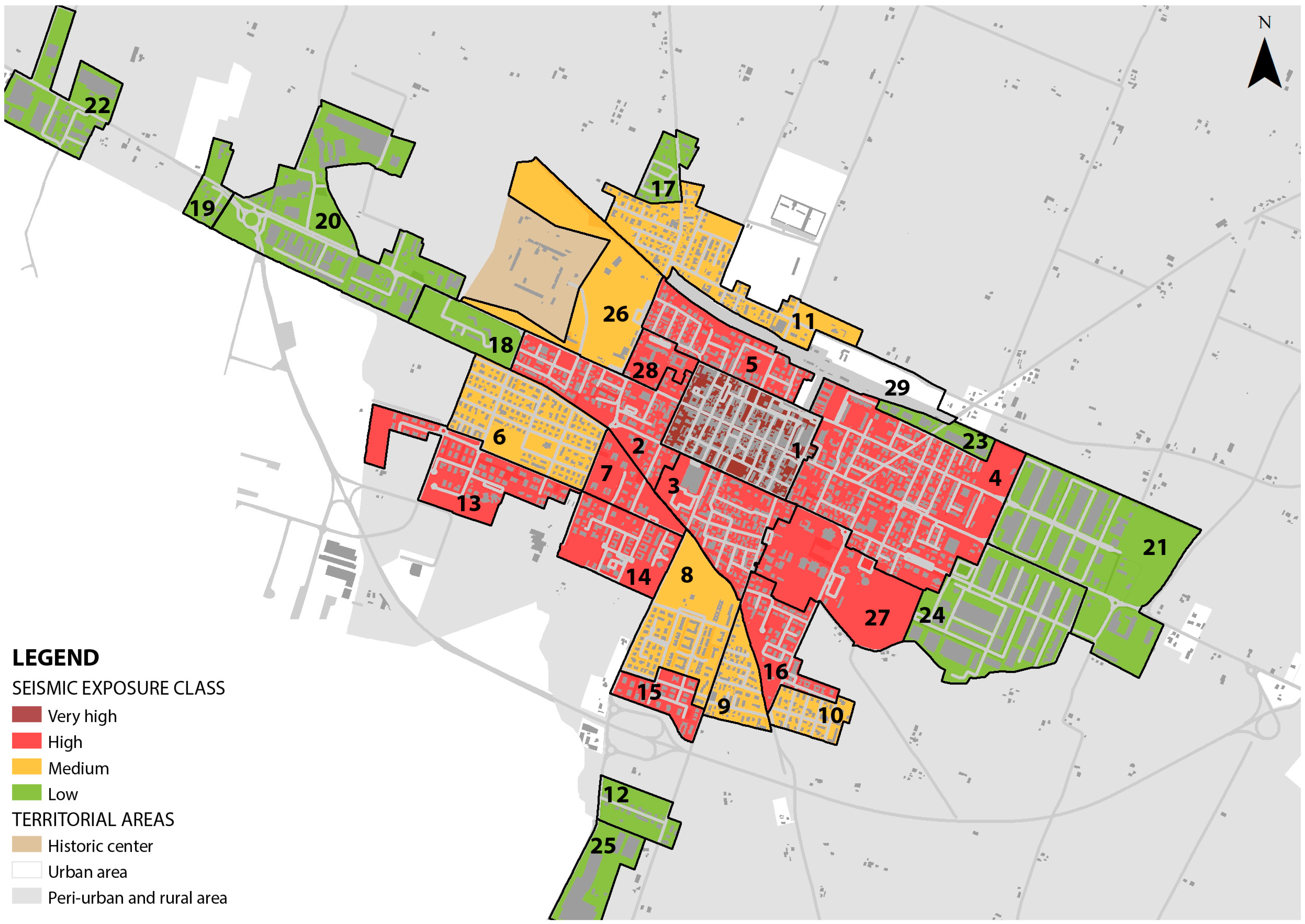
The overall degree of seismic risk is attributed to each homogeneous urban zone in a qualitative way.
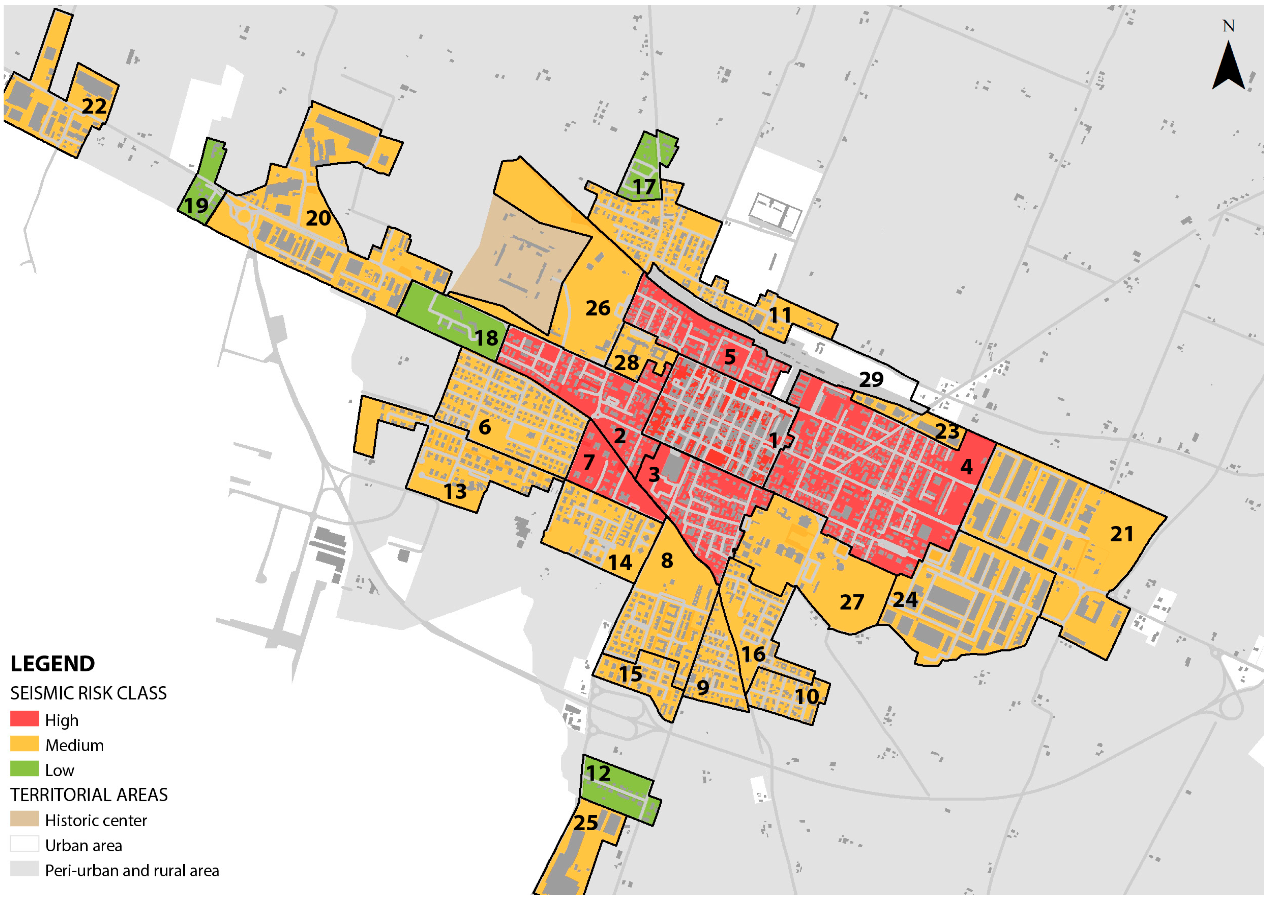
Figure 12 shows these assignments for the homogeneous urban zones in the main town.
4. Discussion
The proposed methodology aims to evaluate the overall seismic risk at the urban scale, referring to homogeneous urban zones, and to identify the relevant information that is needed for proposing mitigation and risk reduction strategies to be integrated into spatial planning tools. The thematic maps give an overview of the situation of the city as a whole, representing a highly valuable tool for spatializing the results: they translate in a geographical dimension the results of the vulnerability and exposure assessments, and show the specific degrees of risk that the different parts of the city have. Although the Seismic Risk Map represents the overall result of the application of the method, it is not sufficient to support planning risk-informed strategies. In fact, the Seismic Risk Map does not explicitly highlight the causes generating the risk that can be addressed by specific urban planning norms, but it is rather synthetic information to be interpreted in light of the other two factors, i.e., vulnerability and exposure.
The homogeneous urban zones analyzed are mostly classified as high or medium seismic risk. In the first category, the zones with the largest presence of historic buildings are included: the ancient building stock and the higher concentration of people who live and work in the city center, where, in addition, the highest percentage of commercial and public interest services are located, make this area highly vulnerable and exposed to seismic risk. The same considerations may be extended to the first residential peripheries, characterized by high vulnerability due to the prevalence of buildings with non-recent ages of construction and structural vulnerabilities. These parts of the city are also characterized by high exposure resulting from the high population and building density, the widespread presence of commercial activities, and the location of some relevant public services.
Looking at the medium-seismic-risk class, it is assigned to the majority of the homogeneous urban zones. However, despite an equal overall seismic risk, the zones do differ greatly when it comes to vulnerability and exposure classes. This category includes the second and third residential peripheries, the industrial sites, the school sport hubs, and the healthcare center hub. The oldest residential zones show a high level of seismic vulnerability, corresponding to a building stock with poor resistance capacity, while in the newest ones, buildings present better seismic performance; on the other hand, the exposure values seems to be inverted, since the oldest residential peripheries present lower population and building density due to an urban tissue characterized by single-family villas and single-family or double-family houses, while in the most recent residential areas, the newest condominiums host a higher number of inhabitants. The industrial sites represent a peculiar situation: their seismic vulnerability is high due to the bad seismic resistance of the industrial buildings within them, but the exposure is low because they host a limited number of employees. The school sport and healthcare center hubs are classified as medium seismic risk: the high level of exposure is balanced by the moderate vulnerability of the buildings, which show acceptable seismic capacity.
Lastly, a few homogeneous urban zones are classified as low seismic risk. These are parts of the city identified as the third residential periphery, where recent constructions guarantee good seismic resistance, and where there is low population and building density and a scarcity of commercial and social facilities.
Detecting seismic vulnerability, exposure, and overall risk in the homogeneous urban zones allows us to gain a clear overview of the most relevant elements determining the risk, thus elaborating upon tailored intervention possibilities and strategies for each zone, as well as different priority actions to be implemented.
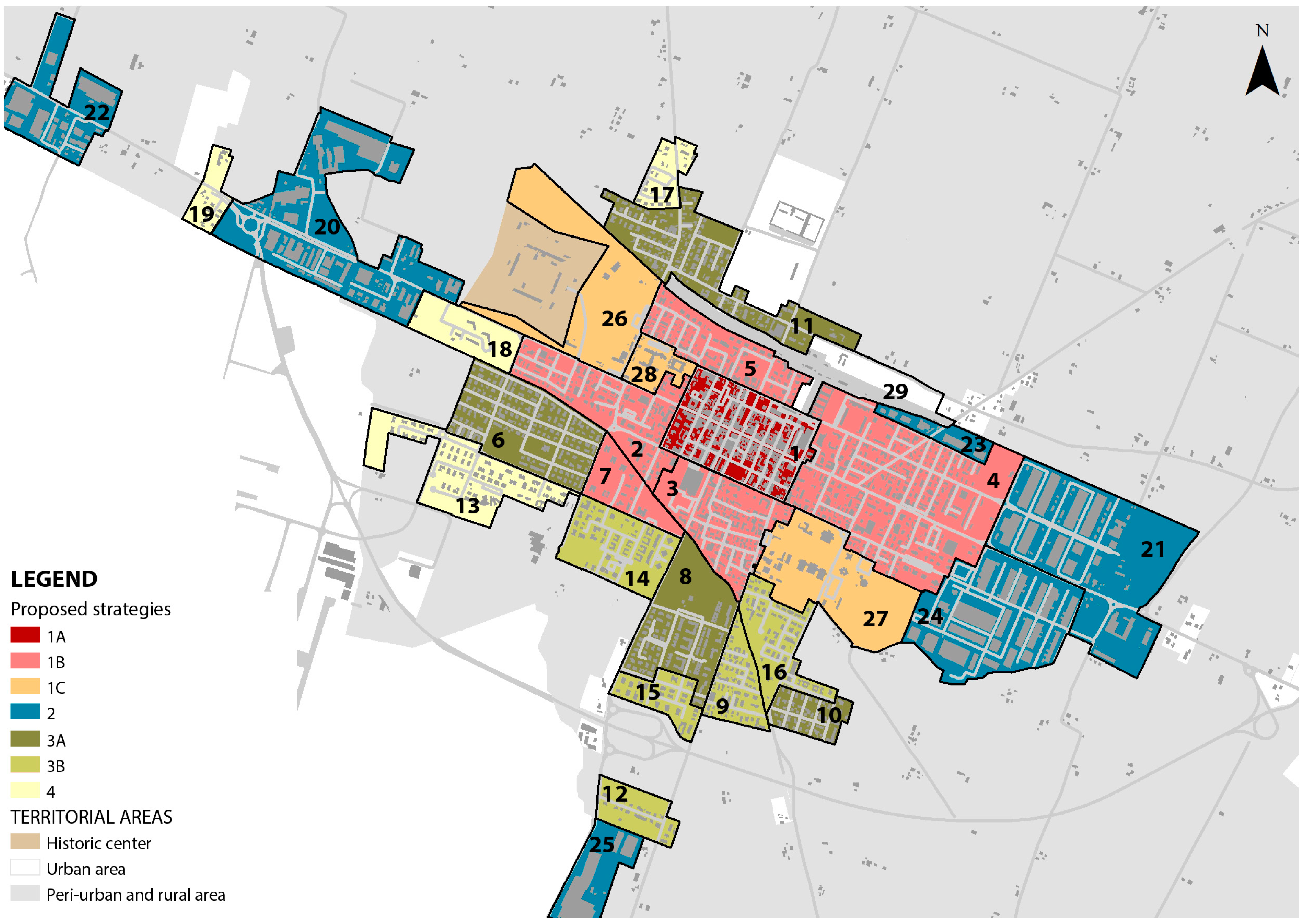
Table 5 presents possible strategies to be included in the urban planning tool for the purpose of addressing seismic risk and enhancing territorial safety. They are configured as general criteria for interventions, aimed at orienting actions of risk mitigation and reduction and implementing an urban project of seismic prevention, moving beyond the building scale to an urban one. The strategies are prioritized as follows.
Priority 1, for homogenous urban zones with high seismic risk and/or with a relevant strategic role for the city as whole: The main objective is to reduce the seismic vulnerability of the building stock, improving its seismic performance in a gradual but widespread manner.
Priority 2, for industrial sites with high levels of seismic vulnerability: The main objective is to reduce the seismic vulnerability of industrial buildings to ensure they remain operative in case of an earthquake.
Priority 3, for homogenous urban zones with medium seismic risk: The main objective is to improve the seismic performance of modern residential buildings.
Priority 4, for homogenous urban zones with low seismic risk: The main objective is to monitor the conditions of the existing building stock.
Figure 13 shows the possible strategies, with the homogeneous urban zones in the main town colored according to the corresponding proposed strategy of intervention described in
Table 5.
5. Conclusions and Limitations
The proposed methodology contributes to a better-informed decision-making process through a rapid assessment of seismic risk based on empirical methods for considering vulnerability and exposure, which expands from the building scale to the urban one. It facilitates the analysis phase required for the development of regeneration strategies for the urbanized territory, offering detailed and easy-to-read information for an urban area, both in terms of numerical values and geo-referenced data. One peculiarity of the method lies in the proposed vulnerability assessment, an empirical approach able to overcome some barriers detected in other similar and frequently used methods, such as the CARTIS one. The proposed method does not need to deeply involve local expert professionals, who should have extensive knowledge of the urban realm [
28]. This requirement could be an important barrier to the correct application of the CARTIS method that is overcome by the proposed methodology. Moreover, the proposed assessment goes beyond the mere definition of the seismic risk, as they are functional to in defining specific and targeted planning strategies for risk reduction.
Nevertheless, we also recognize some limitations and possible future trends of research. The seismic risk depends on three factors, namely,
hazard,
vulnerability, and
exposure, where
hazard measures the potential of an earthquake to produce harm,
vulnerability represents the proneness of considered buildings to suffering damages in case of an earthquake, and
exposure evaluates the size of the population exposed to harm. In the proposed methodology, the hazard factor only refers to the national seismic classification, according to which the whole Municipality of Castelfranco Emilia presents a low-to-medium level of seismic hazard, calculated as values of expected shaking on rigid ground and horizontal topographic surfaces. Nevertheless, it is acknowledged that the geological and geotechnical features of a site may influence the level of the seismic ground shaking that is experienced [
63]. Therefore, integrating more in-depth studies on the seismic hazard factor would allow for a more detailed mapping of the risk conditions in the urban area and would allow for a strengthened and more integrated knowledge of possible damage conditions. In addition, it is relevant to notice that, in the seismic exposure assessment, the different E
ha values calculated for the four main urban uses all had the same weight. The development and application of certain corrective coefficients in these estimates may drastically change the results of the overall risk assessment; however, it seems particularly crucial to recognize that exposed elements in an urban area do not have the same economic, social, cultural, and identity values. As highlighted by Maragno et al. [
34], the decision to give greater importance, and therefore greater weight, to some of these elements (e.g., schools rather than industrial facilities) is a political choice, and it should be addressed and properly discussed. Finally, having access to reliable and updated data, both on the existing building stock and on the most relevant territorial features and dynamics, is essential.
In conclusion, the proposed methodology for seismic risk assessment at the urban scale, as applied to the case study of Castelfranco Emilia in the Emilia-Romagna region, Italy, highlights that increasing quality and quantity of data, systematically collected and geo-referenced, results in more accurate risk assessments and more effective decisions. Structuring information systems conceived to easily map and continuously update building characteristics could reduce the time needed to identify geometrical, typological, and constructive parameters and to divide the building stock into the typological sample categories. In this way, civil servants and decision makers can obtain a comprehensive understanding of where it is more urgent to intervene, as well as how to support risk reduction planning and develop place-specific risk mitigation strategies. Indeed, this method also provides useful insights into strategies, actions, and measures in the form of guidelines and recommendations regarding where and how to intervene according to different priorities and urgent needs.


