Article

Identification of Harbin Ecological Function Degradation Areas Based on Ecological Importance Assessment and Ecological Sensitivity

1
College of Landscape Architecture, Northeast Forestry University, Harbin 150040, China
2
School of Architecture and Design, Harbin Institute of Technology, Harbin 150006, China
3
Key Laboratory of National Territory Spatial Planning and Ecological Restoration in Cold Regions, Ministry of Natural Resources, Harbin 150006, China
4
Harbin Municipal Government Investment Project Service Center, Harbin 150077, China
*
Author to whom correspondence should be addressed.
Sustainability 2024, 16(16), 6763; https://doi.org/10.3390/su16166763
Submission received: 10 July 2024 / Revised: 31 July 2024 / Accepted: 2 August 2024 / Published: 7 August 2024

Abstract

This study is based on the National Spatial Ecological Protection and Restoration Plan, using logical ecological evaluation indicators to determine the extent of ecological function degradation areas in Harbin City. In the Heilongjiang Province, Harbin faces severe ecological environment degradation, characterized by reduced area, deteriorated water quality, loss of biodiversity, and water resource competition. Identifying degraded ecological regions can effectively address these environmental issues. A multi-level indicator system was constructed to evaluate and identify ecological important and sensitive areas across the city, followed by integrating these results to delineate various levels and types of ecological protection and restoration zones in Harbin. Results indicate that these zones include ecological priority protection areas such as marshes surrounding the Harbin section of the Songhua River, southern aquatic wetlands, and scattered forest conservation areas. Key ecological restoration areas are found in the eastern urban core of Harbin, as well as in Bayan County, Bin County’s northern region, Wuchang City’s northwest region, and Yilan County. General ecological restoration areas are primarily distributed in Songbei District, Shuangcheng District, Mulan County, southeastern Bin County, Shangzhi City, southeastern Wuchang City, and some surrounding counties along the Songhua River. Priority ecological protection areas consist mainly of unused land, cultivated land, and forests, while key and general ecological restoration areas are predominantly composed of cultivated land and forests respectively.

1. Introduction

Ecosystems represent vital natural resources and wealth essential for human survival and development, continually furnishing ecological products and services crucial for our well-being. However, rapid urban expansion and economic growth have exerted unprecedented pressure on natural ecosystems, leading to varying degrees of degradation [1,2,3,4,5]. Ecological protection and restoration emerge as imperative strategies to ameliorate the ecological environment, enhance ecosystem service functionality, and uphold ecological security. In the context of advancing towards a new stage of development, characterized by ecological civilization, the systematic promotion of ecological protection and restoration has become a paramount research agenda, garnering considerable attention both domestically and internationally [6].
Current scholarly investigations predominantly focus on specific aspects such as polluted soil restoration, degraded forest rehabilitation, mine land reclamation [7,8], and lake water ecological revitalization, often overlooking the holistic nature of ecosystem protection and the systemic approach required for restoration and governance [9,10,11]. To address these shortcomings, recent years have witnessed the emergence of ecological restoration initiatives characterized by regional, comprehensive, and systematic features.
However, research pertaining to the ecological protection and restoration of territorial spaces has primarily concentrated on smaller scales, such as watersheds, districts, and counties, with limited exploration on larger provincial scales, often restricted to localized areas and ecological corridors. Recognizing the strategic importance of ecological protection and restoration within the national territory, the planning of ecological protection and restoration of territorial spaces assumes significance within the territorial planning framework [12,13,14]. It serves as a foundational plan guiding the implementation of ecological protection and restoration efforts nationwide, with the identification and delineation of protection and restoration zones forming a pivotal component.
The process of identifying and delimiting these zones is guided by the overarching principles of comprehensiveness, inclusivity, and regional relevance, employing methodologies that integrate ecological function indicators and consider social and economic development factors. In this context, the establishment of a regional ecological protection and restoration prioritization evaluation method, based on ecosystem service importance and ecological sensitivity, has gained widespread traction in current research endeavors.
In light of Harbin’s rapid economic and social development, its ecological environment has been significantly disrupted, underscoring the urgent need for comprehensive ecological protection and restoration initiatives to ensure the city’s sustainable development trajectory. Furthermore, as a significant city in Heilongjiang Province, Harbin possesses abundant natural resources, including wetlands, forests, and arable soils. However, accelerated urbanization and economic development pressures have led to severe degradation and deterioration of Harbin’s ecosystem [15,16,17,18]. The issues of shrinking natural habitats, deteriorating water quality, and declining biodiversity have become increasingly prominent, severely impacting the local ecology and sustainable development. Therefore, ecological restoration in Harbin has become an urgent priority. The main objective of ecological restoration in Harbin is to restore and rebuild the functionality and structure of wetland ecosystems, achieving sustainable utilization and ecological protection of wetlands [19]. Specific objectives include (1) the restoration of ecological functions through restoration and ecological engineering methods, restoring local hydrological, soil, vegetation, and other ecological functions, and rebuilding the integrity and stability of the ecosystem [20,21]; (2) the improvement of the ecological environment by implementing ecological restoration measures to improve water quality, air quality, and reduce pollutant emissions in Harbin’s wetlands, enhancing the quality of life for surrounding residents [22]; (3) protecting biodiversity by restoring and rebuilding wetland ecosystems, providing favorable habitat conditions, and preserving/increasing biodiversity within the ecosystem, maintaining ecological balance [23,24,25]; and (4) achieving sustainable development by integrating ecological protection and utilization with Harbin City’s sustainable development goals, aiming to unify ecological, economic, and social benefits, thereby promoting urban sustainability [26]. Current pressing issues include habitat loss, deteriorating water quality, water scarcity, and declining biodiversity. Therefore, this study, based on a comprehensive assessment of ecological importance and sensitivity, identifies and delineates conservation and restoration areas in Harbin City. This provides a scientific basis for ecological protection and restoration in Harbin’s national spatial planning.

2. Materials and Methods

2.1. Main Research Content

The specific research content of this project is as follows: Currently, research in China on ecological restoration of land space mostly focuses on individual ecological issues, lacking a comprehensive theory for ecological restoration across land space and a precise classification system for ecological restoration projects. This study utilizes high-resolution remote sensing imagery and results from the national land survey (“three surveys”), employing remote sensing interpretation, spatial analysis, hierarchical analysis, weighted overlay analysis, and planning techniques. It integrates field surveys and current situation analyses, using an ecological importance evaluation index system and single-factor evaluation models to conduct ecological importance assessments of land space. This includes delineating areas of ecological importance and constructing a model for the ecological importance of land space. The study categorizes ecological importance levels for different regions, establishes a land space restoration planning framework based on ecological importance, proposes significant ecological restoration projects and their planning layouts, and identifies areas in urgent need of wetland restoration within the study area. The specific research content is divided into three main aspects:
(1)
Reviewing domestic and international research on the ecological importance assessment and ecological restoration of land space and understanding the tasks, requirements, content, and framework of land space ecological restoration planning to prepare for further research.
(2)
Evaluating the ecological sensitivity and importance of Harbin City. This involves comprehensive analysis of the study area’s overview and natural, economic, and social conditions. Preprocessing basic data such as terrain slope, vegetation cover, elevation, climate, and land use types using ArcGIS 10.8, factors such as road accessibility, elevation, land use type, slope, and vegetation cover are selected for sensitivity assessment. Analysis of the ecological sensitivity of Harbin City’s environment, followed by an analysis of the ecological service function importance through assessments of soil conservation, water source conservation, habitat quality, carbon fixation, oxygen release, and habitat quality are conducted. Overlaying the results of these analyses identifies ecological degradation areas and identifies Harbin City’s wetland degradation areas in conjunction with wetlands.
(3)
Based on the results of ecological importance assessment, the study area is divided into land space ecological restoration zones and key areas are identified for ecological restoration. Considering the natural environment and current land use status of the study area, planning five types of ecological restoration projects and laying out corresponding ecological restoration projects in a rational manner is carried out.

2.2. Study Area Overview

Harbin, the capital city of Heilongjiang Province, China, covers a total area of approximately 53,100 square kilometers (Figure 1). Geographically, it is situated between 125°42′–130°10′ east longitude and 44°04′–46°40′ north latitude, serving as a significant industrial development center in the northeast region of China. Harbin shares borders with Mudanjiang and Qitaihe to the east, and Yichun and Jiamusi to the north. To the west, it borders Suihua and Daqing, while to the south, it adjoins Changchun, Jilin, Jilin City, and Yanbian Korean Autonomous Prefecture in Jilin Province.
Harbin experiences distinct four seasons, characterized by a continental monsoon climate with moderate temperatures. Winters are long and cold, while summers are brief and cool. In recent years, effective protection mechanisms have been established for wetlands in Harbin. However, extensive agricultural and pastoral activities, such as aquaculture and agricultural production, have led to serious pollution in surrounding watersheds. Additionally, urban development and human activities have significantly damaged the ecological health of wetlands. Therefore, the identification of degraded wetland areas in Harbin is essential to guide ecological conservation and restoration efforts effectively.

2.3. Data Sources

The data used in this study include the land use data of Harbin for the three periods of 2000, 2010, and 2022, which were obtained from the cloud platform of national geographic condition monitoring (http://www.dsac.cn/ (accessed on 13 December 2023)). The data of annual average precipitation evapotranspiration for the three periods of 2000, 2010, and 2000 were obtained from the website of the Global Geographic Information Public Products (http://www.globallandcover.com (accessed on 13 December 2023)). The 2010 Harbin soil texture type data from the World Soil Database (https://www.fao.org/home/en/ (accessed on 21 December 2023)), Harbin domain vector boundary data, 2018 water environment monitoring data, 2005 multi-objective chemical survey (MOCS) soil sampling point data, and 2022 Harbin daily PM2.5 and NO2 air pollution data were obtained from the China Air Quality Online Monitoring and Analysis Platform (https://www.aqistudy.cn/historydata (accessed on 22 December 2023)).

2.4. Research Methodology

2.4.1. Ecological Importance Assessment

Currently, the assessment of ecosystem service function importance primarily relies on modeling and equivalent factor methods. Among these, the modeling approach proves more suitable for large-scale evaluations due to its higher precision. Considering Harbin’s extensive water network and abundant rivers and lakes, evaluating the importance of the water environment becomes particularly pertinent. Furthermore, aligning with the current focus on dual-carbon strategies and biodiversity preservation, a comprehensive evaluation of Harbin’s ecological significance was deemed necessary, focusing on five key aspects: water conservation, carbon sequestration and oxygen release, habitat quality, soil and water conservation, and water storage and flood control [27,28]. The data of 2000, 2010, and 2022 for each indicator were made separately, and then the raster calculator module of the ArcGIS platform was used to evaluate each ecological factor in the study area in 2000, 2010, and 2022.
To operationalize this evaluation, the water conservation function was assessed using the water balance model, while the InVEST model was employed to measure carbon sequestration, oxygen release, and habitat quality functions. Soil and water conservation function assessment relies on the erosion equation, while the evaluation of water storage and flood control function utilizes data pertaining to lakes, rivers, reservoirs, and depressions within the study area. The specific indices and measurement methodologies are detailed in Table 1.
Following the normalization of each factor’s evaluation results, a natural breakpoint method was employed to categorize them into four grades: extremely important, important, more important, and less important. The graded values were then aggregated to compute the composite ecological importance factor grade index.

2.4.2. Comprehensive Factors of Ecological Importance

In this study, based on unobstructed access to foundational data, the evaluation of water environment importance, particularly in conjunction with wetland data in Harbin, was deemed crucial. Moreover, considering current research hotspots such as the dual carbon strategy and biodiversity conservation, a comprehensive evaluation of ecological importance in Harbin was ultimately determined from five aspects: water source conservation, carbon sequestration and oxygen release, habitat quality, soil and water conservation, and water storage and flood regulation.
The water source conservation function was assessed using a water balance model, while the carbon sequestration and habitat quality functions utilized the InVEST (integrated valuation of environmental services and trade-offs) model. Soil and water conservation function adopted the revised universal soil loss equation (RUSLE) model. The water storage and flood regulation function were measured by assigning values to lakes, rivers, reservoirs, and ponds within the study area. Specific indicators and measurement methods are detailed in Table 1.
After normalizing the evaluation results of each individual factor, the natural breakpoint method was employed to classify them into four levels: extremely important, important, moderately important, and unimportant. The indices of ecological importance were then calculated by summing the assigned values for each level (Table 2).

2.4.3. Evaluation of Ecological Sensitivity

The sensitivity assessment of the ecological environment should fully consider the primary ecological issues and their causes within the study area, as different evaluation factors play varying roles in different regions. Based on principles of scientific validity, representativeness, and systematicity, and referring to the “Technical Interim Provisions on Ecological Functional Zoning” and related research findings, factors pertinent to natural and anthropogenic influences that significantly affect the ecological environment in Harbin were selected for sensitivity analysis. These factors include slope, elevation, road buffer zones, land use types, and vegetation cover, subdividing land use types into cultivated land, grassland, woodland, water bodies, and built-up areas. Drawing from grading standards in “Urban Planning GIS Technology Applications” and employing the ArcGIS platform’s natural breaks method, each sensitivity evaluation factor is categorized into levels of insensitivity, slight sensitivity, moderate sensitivity, high sensitivity, and extreme sensitivity, assigned values of 1, 3, 5, 7, and 9, respectively, thus establishing the single-factor sensitivity grading standards for the ecological environment in Harbin, as detailed in Table 3.

2.4.4. Identification and Delineation of Ecological Protection and Restoration Areas

The preliminary results of key ecological protection areas with very high ecological importance levels in 2000, 2010, and 2022 were compared with the latest results of ecological protection red line delineation in Harbin to form the final key ecological protection areas. The difference between the ecological importance of Harbin in 2022 and that of 2000 was calculated using the raster calculator, and the areas with higher degradation of ecological importance were recognized as ecological function degradation areas according to the natural breakpoint method.

3. Results

3.1. Changes in Ecological Importance and Identification of Degraded Areas in Harbin

3.1.1. Changes in the Ecological Importance of China’s Soil Space over the Past 20 Years

The results of the comprehensive assessment of Harbin’s ecological importance are shown in Figure 2. In 2000, 2010, and 2022, most of the city’s land area was in the ecologically important area and the ecologically very important area, and the level of ecological importance was generally increasing. Among them, the ecologically very important area accounted for 5.64%, 12.27%, and 14.25% of the city’s area, mainly concentrated in the Daowai District and Pingfang District, and the surrounding district and county waters in recent years are in the very important area; ecologically important areas accounted for the largest percentage of the area of the more important areas and were concentrated in the distribution of the periphery of the city and Bayan County around the degradation of ecologically important areas, with the significance of the level of importance from important to more important. The more important area increased by 8% in 2022; the proportion of ecologically more important areas is higher, but the ecologically extremely important areas are always on the rise (Figure 2).

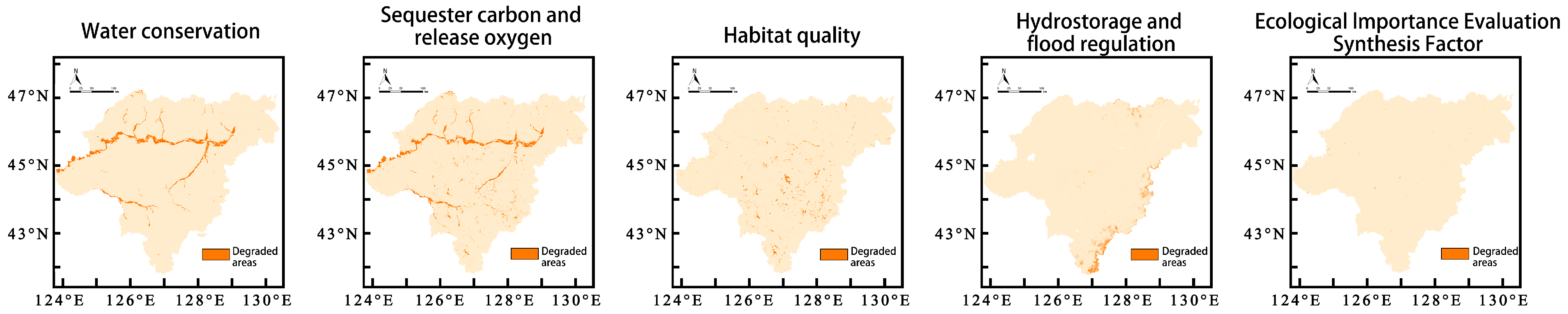
3.1.2. Identification of Areas of Degraded Ecological Functions

In this study, the raster calculator module within ArcGIS was employed to assess changes in each ecological importance factor across the study area for the years 2022, 2010, and 2000. Areas exhibiting decreasing values were identified as degraded areas. The distribution of these degraded areas for each factor, along with corresponding land use changes, is presented in Table 4 and Figure 3.
Over the period from 2000 to 2022, the primary types of ecological degradation in the city encompassed water source containment function, biodiversity conservation function, and carbon sequestration and oxygen release function, accounting for 42.28%, 13.21%, and 7.06% of the province’s area, respectively. The main drivers of land degradation were the expansion of urban land area, the reduction of arable land area, and the decline of natural land areas such as wetlands, water bodies, and forests.
The results of identifying major ecological degradation areas are depicted in Figure 4 and Table 5. The total area of degraded regions amounts to 23,476.39 km2, comprising 44.26% of the city area, primarily including Bayan County, Yilan County, Fangzheng County, Bin County, and their surrounding waters. Among these, highly degraded areas span 356.84 km2, accounting for 1.52% of the total degraded area, concentrated notably in Daowai District, Songbei District waters, and surrounding waters, as well as Wuchang, Shangzhi, along the river basin. Moderately degraded areas cover 5276.62 km2, representing 22.47%, predominantly concentrated in the surrounding waters of Tonghe County and Fangzheng County, with sporadic distribution in Hulan District, Bayan County, and Pingfang District. Low degradation areas, totaling 7714.34 km2, accounting for 32.86%, are primarily concentrated in Wuchang and Shangzhi. Meanwhile, low degradation areas of 10,128.59 km2, accounting for 43.14%, are distributed throughout the city, showcasing a trend of centralized and continuous distribution. The top three degraded areas in terms of ecological importance are identified as degraded ecological function areas in Harbin.

3.2. Identification of Ecologically Sensitive Areas in Harbin

The results of the ecological sensitivity assessment are shown in Figure 5. Using the natural breaks method, ecological sensitivity zones are categorized into highly sensitive areas, moderately sensitive areas, slightly sensitive areas, and non-sensitive areas. The spatial distribution characteristics of ecological sensitivity single-factor elements reveal varying degrees of sensitivity to natural ecological processes and human disturbances in different regions. In Harbin, areas highly sensitive to slope are mainly located in the southern parts of Shangzhi and Wuchang, as well as the northern part of Tonghe County, with additional concentrations in the southern part of Bin County. Highly sensitive elevation areas in Harbin are predominantly found in the southern parts of Shangzhi and Wuchang, and the northern part of Tonghe County, while non-sensitive areas are mainly distributed along both banks of the Songhua River. In the assessment of ecological sensitivity related to road buffer zones, the overall distribution pattern of road buffer zone factors shows a gradual increase in sensitivity from inner to outer areas. Regarding the assessment of ecological sensitivity related to land use types in Harbin, the distribution characteristics of land use type factors align consistently with land use nature. In the evaluation of vegetation cover in Harbin, highly sensitive areas are predominantly located in Tonghe County, Acheng District, and the southern parts of Harbin. Comprehensive assessment of ecological sensitivity in Harbin reveals that non-sensitive areas are the largest in terms of area, followed by slightly sensitive areas, primarily located in administrative districts outside the city center. Thus, the ecological sensitivity of Harbin is mainly characterized by slight and non-sensitivity, with highly sensitive areas mainly distributed along the Songhua River and dispersed in small quantities within the urban area, and slightly sensitive areas mainly located in the southeastern border areas and a few northern regions of Harbin.

3.3. Harbin Wetland Ecological Protection and Restoration Area Delineation Results

By integrating the research findings from above, Harbin City has ultimately constructed an overall ecological conservation and restoration framework comprising ecological protection priority areas, ecological restoration key areas, and ecological restoration general areas (Figure 6).
The ecological protection priority areas cover an area of 2527 km2, accounting for 4.83% of the city’s total area. This includes wetlands surrounding the Songhua River’s Harbin section, southern aquatic wetlands, and scattered forest reserves. The area is predominantly comprised of unused land, farmland, and forests, accounting for 98.67%, 0.31%, and 0.83% of the area, respectively (Table 6), primarily concentrated in undeveloped wetland marsh areas around the Songhua River’s Harbin section.
The ecological restoration key areas span a total of 27,321 km2, covering 52.31% of the city’s total area. These are distributed in the eastern main urban area of Harbin City, as well as in Bayan County, Bin County’s northern part, northwest Wuchang City, and Yilan County. Due to significant human activity disturbances, the eastern urban areas of Harbin urgently require ecological conservation and restoration projects. This region is mainly concentrated in peri-urban areas, primarily composed of farmland, which accounts for 73.73% of the total area.
The ecological restoration general areas encompass an area of 22,383 km2, representing 42.86% of the city’s total area. They are mainly found in Harbin’s Songbei District and Shuangcheng District, Mulan County, the southeastern part of Bin County, Shangzhi City, and the southeastern part of Wuchang City, with some areas distributed in counties around the Songhua River. This region is predominantly forested, with forests covering 73.44% of the total area.
From 2000 to 2022, construction land within key areas and general areas increased by 4861 km2 and 5547 km2, respectively, reflecting a trend of continual encroachment upon various natural and farmland areas. During this period, forests, grasslands, and water bodies collectively decreased by 1609 km2, with construction land encroachment leading to the degradation of their corresponding ecological functions. Farmland, primarily used as the main source of conversion to construction land, saw reductions of 1025 km2 and 1139 km2, respectively. Harbin City’s predominant dryland farming type is capable of absorbing and storing water, stabilizing soil, sequestering carbon dioxide, and providing habitats for microorganisms, thus the decrease in farmland due to rapid urbanization has become a common factor contributing to the degradation of various ecological functions.

4. Discussion

The natural and ecological environments within a region are increasingly disturbed by the development of social economy and human activities. Therefore, identifying regional ecological protection areas based on the characteristics of the regional ecological environment and proposing localized ecological protection and planning strategies to enhance sustainable ecological development are pressing issues.
(1)
In terms of research methods, this paper evaluates the ecological environment sensitivity and the importance of ecosystem services in Harbin using GIS spatial analysis methods. By spatially overlaying the evaluation results of these two aspects and conducting a comprehensive assessment, the ecological functions of Harbin are partitioned. The overlay of sensitivity and importance results increase the scientific accuracy of identifying ecological protection areas. Previous studies often analyzed the sensitivity or importance of a region’s ecology from a single factor or ecosystem perspective, which did not comprehensively reflect the overall natural ecology of the area [29]. Therefore, by combining the sensitivity and importance and integrating the sensitivity results of individual factors, this study enhances the comprehensiveness and realism of the evaluation. Importance is also assessed from various indicators, such as water conservation, carbon sequestration, habitat quality, soil and water conservation, and flood regulation, providing a new approach for identifying ecological protection areas in Harbin and offering a reference for scientifically evaluating sensitivity and importance for ecological protection.
(2)
Using Harbin as a study area, this research evaluates the city’s ecological sensitivity through a multi-factor evaluation system, considering factors such as slope, elevation, road buffer zones, land use types, and vegetation coverage. The results indicate that areas with high ecological sensitivity in Harbin are mainly concentrated around the marshes surrounding the Harbin section of the Songhua River, southern water wetlands, and scattered forest protection zones. These areas are more vulnerable to damage under extreme weather conditions due to their lack of protection, making their ecological environment fragile and highly sensitive. The response degree of different areas to various ecological sensitivity factors varies [30,31]. For instance, mountainous regions with high elevation are more sensitive to factors like slope and elevation, while karst landforms and mineral-rich areas are more sensitive to vegetation coverage factors [32]. In Harbin, as a rapidly developing provincial capital, areas with frequent human activities are more sensitive to road buffer zones and land use factors [33]. Therefore, improving the environmental conditions in Harbin’s highly sensitive areas requires targeted protection or restoration of critical ecological factors, integrating natural conditions for effective ecological protection.
(3)
The importance of Harbin’s ecosystem services was evaluated through models of water conservation, soil and water conservation, habitat quality, carbon sequestration, and flood storage and regulation [34,35,36]. Referring to previous research results, it was found that extremely important areas are fundamental to Harbin’s ecological environment protection and are significant for the region’s ecological security framework. Apart from unimportant areas, important areas not only cover the largest portion of Harbin’s ecosystem service importance ranking but also hold potential for ecological environment development, playing a crucial role as a support for Harbin’s ecological environment. Generally important areas are relatively scattered and require focused attention for ecological protection. The evaluation results of Harbin’s ecosystem service importance indicate that the city’s ecosystem services mainly rely on the stability of the Harbin section of the Songhua River basin, with areas of poor ecosystem services being sparsely distributed in less populated areas, aligning with the actual situation of Harbin’s ecological environment, proving the feasibility of the study.
(4)
Based on the current ecological environment of Harbin, this study constructs degraded ecological function zones through the evaluation of ecological sensitivity and the importance of ecosystem services, thus establishing ecological protection planning zones for Harbin. The final results show that key and general ecological protection zones cover the largest areas, while important protection zones cover the smallest area, predominantly consisting of unused land. Future work should focus on the rational use and planning protection of these areas, such as increasing afforestation zones, to enhance the stability of Harbin’s ecological security. Moreover, by overlaying the evaluation results of Harbin’s ecological sensitivity and the importance of ecosystem services and referring to multiple studies [37,38,39,40,41], the identified ecological protection zones in Harbin show some discrepancies but generally align with the city’s ecological environment, providing clear objectives for future ecological protection and development in Harbin.

5. Conclusions

In this study, Harbin City in Heilongjiang Province, China, was chosen as the research area to integrate the results of ecological importance and sensitivity evaluations. Regions where ecological importance remains consistently high are designated as key ecological protection zones, while areas with significant decline in ecological importance are identified as ecological function degradation zones. By overlaying these findings with the identification results of ecologically sensitive areas, we delineate key ecological protection zones, critical ecological restoration areas, and general ecological restoration areas. The main conclusions are as follows:
(1)
The city’s ecological protection and restoration zones can be divided into key ecological protection zones, critical ecological restoration areas, and general ecological restoration areas. The respective areas of these zones are 2527 km2, 27,321 km2, and 22,383 km2, accounting for 4.83%, 52.31%, and 42.86% of the city’s total area.
(2)
The key ecological protection zones primarily include the marshlands around the Harbin section of the Songhua River, southern water wetlands, and scattered forest protection areas. The critical ecological restoration areas mainly consist of the eastern main urban area of Harbin, as well as Bayan County, the northern part of Bin County, the northwestern part of Wuchang City, and Yilan County. The general ecological restoration areas primarily include the Songbei and Shuangcheng districts of Harbin, Mulan County, the southeastern part of Bin County, Shangzhi City, and the southeastern part of Wuchang City, along with some counties surrounding the Songhua River.
(3)
The key ecological protection zones feature ecosystems dominated by unused land, arable land, and forest land. The critical ecological restoration areas are primarily characterized by arable land as the main land use type, while the general ecological restoration areas are mainly composed of forest land.
This study quantitatively calculates the importance of water conservation, carbon sequestration and oxygen release, habitat quality, soil and water conservation, and flood regulation functions in Harbin City for the years 2000, 2010, and 2022 using various ecological models. Regions with consistently high ecological function and areas showing degradation in ecological importance are selected as preliminary ecological protection and restoration zones. Furthermore, these preliminary results are overlaid with the identification of ecologically sensitive areas to prioritize and delineate key ecological protection zones, critical ecological restoration areas, and general ecological restoration areas.
Due to data and methodological limitations, this study only considers the impact of slope, elevation, road buffers, land use, and vegetation cover on ecological sensitivity. However, the factors influencing ecological sensitivity are highly complex, requiring the inclusion of additional variables such as water quality, soil conditions, air pollution, and habitat fragmentation for a more comprehensive assessment. Future studies should refine and deepen the construction of related indices. This study designates areas with significant degradation in ecosystem service importance as ecological restoration zones, without fully considering factors such as ecosystem resilience and regional land use planning policies. Subsequent research should account for the diversity and openness of regional ecosystems, Harbin City’s development policies, and other factors to comprehensively evaluate the feasibility of ecological restoration efforts.

Author Contributions

Conceptualization, Q.Z. and Y.W.; methodology, Q.Z.; software, Q.Z.; validation, Q.Z., Y.W. and Z.Z.; formal analysis, Q.Z.; investigation, Q.Z. and Y.W.; resources, Y.W. and Z.Z.; data curation, Q.Z.; writing—original draft preparation, Q.Z.; writing—review and editing, Q.Z. and Y.W.; visualization, Y.W.; supervision, Y.W.; project administration, Y.W. and Z.Z.; funding acquisition, Y.W. All authors have read and agreed to the published version of the manuscript.

Funding

This research received no external funding.

Institutional Review Board Statement

Not applicable.

Informed Consent Statement

Informed consent was obtained from all subjects involved in the study.

Data Availability Statement

The raw data supporting the conclusions of this article will be made available by the authors on request.

Conflicts of Interest

The authors declare no conflict of interest.

References

  1. Benayas, J.M.R.; Newton, A.C.; Diaz, A.; Bullock, J.M.J. Enhancement of biodiversity and ecosystem services by ecological restoration: A meta-analysis. Science 2009, 325, 1121–1124. [Google Scholar] [CrossRef] [PubMed]
  2. Foley, J.A.; DeFries, R.; Asner, G.P.; Barford, C.; Bonan, G.; Carpenter, S.R.; Chapin, F.S.; Coe, M.T.; Daily, G.C.; Gibbs, H.K.J. Global consequences of land use. Science 2005, 309, 570–574. [Google Scholar] [CrossRef]
  3. Lawler, J.J.; Lewis, D.J.; Nelson, E.; Plantinga, A.J.; Polasky, S.; Withey, J.C.; Helmers, D.P.; Martinuzzi, S.; Pennington, D.; Radeloff, V.C. Projected land-use change impacts on ecosystem services in the United States. Proc. Natl. Acad. Sci. USA 2014, 111, 7492–7497. [Google Scholar] [CrossRef] [PubMed]
  4. Newbold, T.; Hudson, L.N.; Hill, S.L.; Contu, S.; Lysenko, I.; Senior, R.A.; Börger, L.; Bennett, D.J.; Choimes, A.; Collen, B.J. Global effects of land use on local terrestrial biodiversity. Nature 2015, 520, 45–50. [Google Scholar] [CrossRef] [PubMed]
  5. Xu, C.; Liu, M.; An, S.; Chen, J.; Yan, P.J. Assessing the impact of urbanization on regional net primary productivity in Jiangyin County, China. J. Environ. Manag. 2007, 85, 597–606. [Google Scholar] [CrossRef] [PubMed]
  6. Zhang, Y.; Zhao, X.; Gong, J.; Luo, F.; Pan, Y. Effectiveness and driving mechanism of ecological restoration efforts in China from 2009 to 2019. Sci. Total Environ. 2024, 910, 168676. [Google Scholar] [CrossRef] [PubMed]
  7. Clifford, M.J.; Ali, S.H.; Matsubae, K.J. Mining, land restoration and sustainable development in isolated islands: An industrial ecology perspective on extractive transitions on Nauru. AMBIO 2019, 48, 397–408. [Google Scholar] [CrossRef] [PubMed]
  8. Knutti, J.; Braunisch, V.; Pellet, J.; Arlettaz, R. Improving longitudinal habitat connectivity in major river restoration projects through farmland re-allocation. J. Nat. Conserv. 2021, 64, 126062. [Google Scholar] [CrossRef]
  9. Guan, Y.; Kang, R.; Liu, J. Evolution of the field of ecological restoration over the last three decades: A bibliometric analysis. Restor. Ecol. 2019, 27, 647–660. [Google Scholar] [CrossRef]
  10. Li, Z.; Chang, J.; Li, C.; Gu, S.J. Ecological restoration and protection of national land space in coal resource-based cities from the perspective of ecological security pattern: A case study in Huaibei City, China. Land 2023, 12, 442. [Google Scholar] [CrossRef]
  11. Xing, L.; Hu, M.; Wang, Y. Integrating ecosystem services value and uncertainty into regional ecological risk assessment: A case study of Hubei Province, Central China. Sci. Total Environ. 2020, 740, 140126. [Google Scholar] [CrossRef]
  12. Li, X.; Yu, X.; Wu, K.; Feng, Z.; Liu, Y.; Li, X. Land-use zoning management to protecting the Regional Key Ecosystem Services: A case study in the city belt along the Chaobai River, China. Sci. Total Environ. 2021, 762, 143167. [Google Scholar] [CrossRef] [PubMed]
  13. Wang, C.; Liu, Y.; Yu, C.; Liu, X. Research progress on the arrangement of territorial ecological restoration. Prog. Geogr. 2021, 40, 1925–1941. [Google Scholar] [CrossRef]
  14. Zhai, T.; Wang, J.; Fang, Y.; Qin, Y.; Huang, L.; Chen, Y. Assessing ecological risks caused by human activities in rapid urbanization coastal areas: Towards an integrated approach to determining key areas of terrestrial-oceanic ecosystems preservation and restoration. Sci. Total Environ. 2020, 708, 135153. [Google Scholar] [CrossRef]
  15. Li, X.; Li, W.; Gao, Y. Multi-Scenario Simulation of Green Space Landscape Pattern in Harbin City Based on FLUS Model. Int. J. Environ. Res. Public Health 2023, 20, 4286. [Google Scholar] [CrossRef] [PubMed]
  16. Song, S.; Wang, S.; Shi, M.; Hu, S.; Xu, D.J. Urban blue–green space landscape ecological health assessment based on the integration of pattern, process, function and sustainability. Sci. Rep. 2022, 12, 7707. [Google Scholar] [CrossRef]
  17. Song, S.; Xu, D.; Hu, S.; Shi, M. Ecological network optimization in urban central district based on complex network theory: A case study with the urban central district of Harbin. Int. J. Environ. Res. Public Health 2021, 18, 1427. [Google Scholar] [CrossRef] [PubMed]
  18. Zhang, M.; Chen, W.; Shen, X.; Zhao, H.; Gao, C.; Zhang, X.; Liu, W.; Yang, C.; Qin, Y.; Zhang, S.J. Comprehensive and high-resolution emission inventory of atmospheric pollutants for the northernmost cities agglomeration of Harbin-Changchun, China: Implications for local atmospheric environment management. J. Environ. Sci. 2021, 104, 150–168. [Google Scholar] [CrossRef] [PubMed]
  19. Fu, Y.; Shi, X.; He, J.; Yuan, Y.; Qu, L. Identification and optimization strategy of county ecological security pattern: A case study in the Loess Plateau, China. Ecol. Indic. 2020, 112, 106030. [Google Scholar] [CrossRef]
  20. Guo, R.; Wu, T.; Liu, M.; Huang, M.; Stendardo, L.; Zhang, Y. The construction and optimization of ecological security pattern in the Harbin-Changchun urban agglomeration, China. Int. J. Environ. Res. Public Health 2019, 16, 1190. [Google Scholar] [CrossRef]
  21. He, M.; Wu, Y.; Liu, X.; Wu, B.; Fu, H. Constructing a multi-functional small urban green space network for green space equity in urban built-up areas: A case study of Harbin, China. Heliyon 2023, 9, e21671. [Google Scholar] [CrossRef] [PubMed]
  22. Sui, X.; Frey, B.; Yang, L.; Zhang, R.; Li, M.-H. Soil Acidobacterial community composition changes sensitively with wetland degradation in northeastern of China. Front. Microbiol. 2022, 13, 1052161. [Google Scholar] [CrossRef]
  23. Lin, C.-Y.; Li, X.-L.; Zhang, Y.-X.; Sun, H.-F.; Li, C.-Y.; Jin, L.-Q.; Yang, X.-G.; Liu, K. Responses of different degradation stages of alpine wetland on soil microbial community in the yellow river source zone. Huan Jing Ke Xue = Huanjing Kexue 2021, 42, 3971–3984. [Google Scholar]
  24. Liu, H.; Lin, N.; Zhang, H.; Liu, Y.; Bai, C.; Sun, D.; Feng, J. Driving Force Analysis of Natural Wetland in Northeast Plain Based on SSA-XGBoost Model. Sensors 2023, 23, 7513. [Google Scholar] [CrossRef] [PubMed]
  25. Wang, W.; Zhang, W.; Liang, H.; Gao, D. Seasonal distribution characteristics and health risk assessment of typical antibiotics in the Harbin section of the Songhua River basin. Environ. Technol. 2018, 40, 2726–2737. [Google Scholar] [CrossRef] [PubMed]
  26. Sauvé, S.; Bernard, S.; Sloan, P. Environmental sciences, sustainable development and circular economy: Alternative concepts for trans-disciplinary research. Environ. Dev. 2016, 17, 48–56. [Google Scholar] [CrossRef]
  27. Deng, H.; Zhou, X.; Liao, Z. Ecological redline delineation based on the supply and demand of ecosystem services. Land Use Policy 2024, 140, 107109. [Google Scholar] [CrossRef]
  28. Han, B.; Jin, X.; Xiang, X.; Rui, S.; Zhang, X.; Jin, Z.; Zhou, Y. An integrated evaluation framework for Land-Space ecological restoration planning strategy making in rapidly developing area. Ecol. Indic. 2021, 124, 107374. [Google Scholar] [CrossRef]
  29. Fang, Z.; Ding, T.; Chen, J.; Xue, S.; Zhou, Q.; Wang, Y.; Wang, Y.; Huang, Z.; Yang, S. Impacts of land use/land cover changes on ecosystem services in ecologically fragile regions. The Science of the total environment. Sci. Total Environ. 2022, 831, 154967. [Google Scholar] [CrossRef] [PubMed]
  30. Yi, D.; Zhao, X.M.; Guo, X.; Zhao, L.H.; Zhang, H.; Han, Y.; Roshan, S.; Luo, Z.J. Delimitation of urban development boundary based on ecological sensitivity evaluation and CA-Markov simulation in plain city: A case of Nanchang, Jiangxi, China. Ying Yong Sheng Tai Xue Bao = J. Appl. Ecol. 2020, 31, 208–218. [Google Scholar]
  31. Zhan, M.S.; Zhu, J.H. Spatial planning of Qingyun Mountain scenic spot in Benxi, Northeast China based on ecological sensitivity assessment. Ying Yong Sheng Tai Xue Bao = J. Appl. Ecol. 2019, 30, 2352–2360. [Google Scholar]
  32. Dou, H.M.; Zhao, R.F.; Chen, X.D.; Shi, J.; Wang, J.F.; Liu, F.S. Identification of priority areas for territorial space ecological restoration in arid area of Northwest China: A case study of Zhangye City in Heihe River basin. Ying Yong Sheng Tai Xue Bao = J. Appl. Ecol. 2024, 35, 469–479. [Google Scholar]
  33. Keleş Özgenç, E.; Uzun, O. Impacts of land use/land cover and climate change on landscape sensitivity in Tunca River sub-basin: Use in spatial planning and sectoral decision processes. J. Environ. Manag. 2024, 363, 121372. [Google Scholar] [CrossRef]
  34. Li, Y.; Zhao, J.; Yuan, J.; Ji, P.; Deng, X.; Yang, Y. Constructing the Ecological Security Pattern of Nujiang Prefecture Based on the Framework of “Importance-Sensitivity-Connectivity. Int. J. Environ. Res. Public Health 2022, 19, 10869. [Google Scholar] [CrossRef]
  35. Yang, Y.; Chen, J.; Huang, R.; Feng, Z.; Zhou, G.; You, H.; Han, X. Construction of Ecological Security Pattern Based on the Importance of Ecological Protection-A Case Study of Guangxi, a Karst Region in China. Int. J. Environ. Res. Public Health 2022, 19, 5699. [Google Scholar] [CrossRef] [PubMed]
  36. Yang, Y.; Li, H.; Qian, C. Analysis of the implementation effects of ecological restoration projects based on carbon storage and eco-environmental quality: A case study of the Yellow River Delta, China. J. Environ. Manag. 2023, 340, 117929. [Google Scholar] [CrossRef]
  37. Demir, S.; Demirel, Ö.; Okatan, A. An ecological restoration assessment integrating multi-criteria decision analysis with landscape sensitivity analysis for a hydroelectric power plant project: The Tokat-Niksar case. Environ. Monit. Assess. 2021, 193, 818. [Google Scholar] [CrossRef] [PubMed]
  38. Field, R.D.; Parrott, L. Mapping the functional connectivity of ecosystem services supply across a regional landscape. eLife 2022, 1, e69395. [Google Scholar] [CrossRef] [PubMed]
  39. Fu, B.; Liu, Y.; Meadows, M.E. Ecological restoration for sustainable development in China. Natl. Sci. Rev. 2023, 10, nwad033. [Google Scholar] [CrossRef] [PubMed]
  40. Li, C.; Hou, R.; Bao, Z.; Wu, W.; Owens, J.R.; Bi, W.; Xu, Q.; Gu, X.; Xiang, Z.; Qi, D. Measuring ecosystem services and ecological sensitivity for comprehensive conservation in Giant Panda National Park. Conserv. Biol. J. Soc. Conserv. Biol. 2024, 38, e14215. [Google Scholar] [CrossRef]
  41. Lin, Y.; Rong, Y.; Li, L.; Li, F.; Zhang, H.; Yu, J. Spatiotemporal impacts of climate change and human activities on water resources and ecological sensitivity in the Mekong subregion in Cambodia. Environ. Sci. Pollut. Res. Int. 2023, 30, 4023–4043. [Google Scholar] [CrossRef] [PubMed]
Figure 1. Location and the land use of the study area.
Sustainability 16 06763 g001
Figure 2. Evaluation results of ecological importance of territorial space in Harbin.
Sustainability 16 06763 g002
Figure 3. Distribution of degradation areas of each single factor of territorial ecological importance in Harbin.
Sustainability 16 06763 g003
Figure 4. Distribution of degraded areas of ecological importance in Harbin land space.
Sustainability 16 06763 g004
Figure 5. Evaluation results of ecological sensitivity of territorial space in Harbin.
Sustainability 16 06763 g005
Figure 6. Overall pattern of ecological protection and restoration in Harbin.
Sustainability 16 06763 g006
Table 1. Ecological importance evaluation indicator system and measurement methods.
Type of IndicatorMethods of Measurement
Type of water conservationBased on the water balance model, the spatial differentiation of the water conservation function in the study area was measured with the following formula: W = P − E, where w is the average amount of water conservation (mm), P is the average rainfall (mm), and E is the average evaporation (mm).
Carbon sequestration and oxygen release functionThe carbon stock module of the InVEST model was used to calculate the carbon sequestration and oxygen release function of Harbin, and the model formula was as follows: Ctot = Cabove + Cbelom + Csoil + Cdead, where Cabove denotes the above-ground vegetation carbon pool, Cbelom denotes the below-ground vegetation carbon pool, Csoil denotes the soil carbon pool, and Cdead denotes the carbon stock in the dead wood, withered wood, and fallen wood. Due to data limitations, the carbon pools in this study were summarized as vegetation carbon pools and soil carbon pools, and the unit was kg/m2.
Habitat quality functionThe formula for the habitat quality module of the InVEST model is as follows:
Qxj = Hj [(1 − Dzxj/Dzxj + k2)],
where Q is the habitat quality of grid x in land use type j, H is the habitat suitability of the land use type and the half-saturation parameter, z is the normalization constant, usually taken as 2.5, D is the stress level of grid x in the land use type.
Soil conservation functionThe calculation of the soil and water conservation function of Harbin based on the RUSLE model was conducted with the following equations:
A = –R·K·LS·C·P,
where A is the average annual soil erosion, R is the rainfall erosivity factor (MJ·mm/hm2·hm2), which reflects the potential capacity of rainfall-induced soil loss, K is the soil erodibility factor (t·h/MJ·mm·hm4), which is used to reflect the erosive resistance of the soil, LS is the slope length and slope gradient factor, of which L is the slope length factor (m), S is the slope gradient factor (unitless), which accelerates the erosion of the soil, C is the cover and management factor (no unit), and P is the soil and water conservation measure factor (no unit).
Function of storing water for flood regulationAssigning values to lakes, rivers and reservoirs, and ponds according to the natural characteristics of the different water bodies.
Table 2. Assignment of ecological importance grade index.
Materiality RatingAssignment of Single-Factor Rating IndicesComposite Factor Rating Index Assignment
extremely important7>24
critical515~24
more important39~15
unimportant1<9
Table 3. Single factor classification standard of ecological environment sensitivity assessment in Harbin.
Evaluation FactorGrading Type
InsensitiveSlightly
Sensitive
Moderately
Sensitive
Highly
Sensitive
Extremely Sensitive
Slope0–5°5–10°10–15°15–25°25–72°
Elevation−139–206 m206–346 m346–553 m553–873 m873–1715 m
Road buffer0–100 m100–150 m150–200 m200–250 m250–1000 m
Land useBuilding landCroplandGrasslandWaterlandWoodland
Vegetation cover0–0.180.18–0.380.38–0.610.61–0.840.84–1
Grading13579
Table 4. Changes in the proportion of land use area within the degraded area of each single factor of spatial ecological importance of land in Harbin.
Area TypeArea (km2)Percentage (%)Cropland (%)Forest Land (%)Grassland (%)Mudflat Wetlands (%)Water Area (%)Urban (%)
Water conservation degradation zone10,395.3544.28−2.810.120.05−3.49−1.368.24
Oxygen sequestration degraded area3101.2313.21−72.36−21.16−0.21−8.3254.7573.28
Habitat quality1657.437.06−15.67−1.76−6.18−3.45−7.8226.89
Soil and water conservation degradation area1986.118.4683.250.360.78−12.67−56.2917.89
Degraded areas for water storage and flood regulation1164.434.962.348.360.124.22−14.5645.78
Table 5. Area and percentage of ecological importance class of land space in Harbin.
Ecological Importance Rating200020102022
Area (km2)Percentage (%)Area (km2)Percentage (%)Area (km2)Percentage (%)
ecologically insignificant area26,658.9150.2618,230.5438.2111,520.7221.72
ecologically more important area12,629.0523.818921.6634.3722,457.9842.34
ecologically important area13,751.6325.936508.2516.8212,295.1423.18
ecologically significant area2991.575.6418,230.5412.277558.4914.25
Table 6. Area and proportion of land use types in each region.
Type of AreaAreaCroplandForest LandGrasslandWater LandBuilding LandUnused Land
Area (km2)Percentage (%)Area (km2)Percentage (%)Area (km2)Percentage (%)Area (km2)Percentage (%)Area (km2)Percentage (%)Area (km2)Percentage (%)
Ecological conservation priorities25277.900.3120.860.831.120.043.140.120.520.022494.0298.67
Ecological restoration of key areas27,32120,143.8973.736295.7823.04842.863.094.080.0125.660.098.940.03
General ecological restoration area22,3833183.0814.2216,437.7773.44305.821.37798.623.571651.847.386.260.03
Disclaimer/Publisher’s Note: The statements, opinions and data contained in all publications are solely those of the individual author(s) and contributor(s) and not of MDPI and/or the editor(s). MDPI and/or the editor(s) disclaim responsibility for any injury to people or property resulting from any ideas, methods, instructions or products referred to in the content.

