Article

Determining the Scale to Ensure Locality and a Sense of Belonging in the Housing Redevelopment Process: Bursa Hürriyet Neighborhood Field Study †

Department of Architecture, Faculty of Architecture, Bursa Uludag University, Görükle Campus, 16059 Bursa, Türkiye
*
Author to whom correspondence should be addressed.
This study has been conducted with the survey works that were applied after getting the ethical board approvals on 27 September 2021 and 28 February 2022 as a part of the doctoral thesis titled “A Model Proposal for Scale and Management Dimension in the Process of Housing Redevelopment”, prepared under the supervision of Nilüfer Taş.
Sustainability 2024, 16(1), 10; https://doi.org/10.3390/su16010010
Submission received: 27 October 2023 / Revised: 1 December 2023 / Accepted: 8 December 2023 / Published: 19 December 2023
(This article belongs to the Special Issue Urban Land Use, Urban Vitality and Sustainable Urban Development)

Abstract

:
Regarding housing redevelopment in Türkiye, the unplanned scale increase is one of the most critical problems facing the cities that have grown due to immigration. One of the most critical problems in housing redevelopment is the inability to ensure locality and retain the current inhabitants. Due to the fact that the issues of locality and ensuring a sense of belonging are ignored in most cases, the housing units usually lack local architectural identity, resemble each other, and do not meet socio-cultural needs. The purpose of this study is to identify locally specific, value-driven results to ensure the continuity of the existing users in the event of housing redevelopment by conducting a field study in the Bursa Hürriyet Neighborhood, which had been formed under the influence of immigration and where the users have adapted over time and preserved their socio-cultural living habits. As a method, a questionnaire was distributed to the users, a list of questions generated with the Delphi technique was posed to the experts, and then both were analyzed. By ensuring the correct reading of local information, suggestions are presented in order to identify the appropriate scale for both users and the city with the “glocal approach” in cities developing under global influences.

1. Introduction

In Türkiye, housing redevelopment applications are being carried out for the purpose of improving the physical structure of settlements, making them resilient to disasters, etc., with the same characteristics. However, there are neighborhoods that can sustain themselves physically, economically, and socio-culturally; that have been able to integrate with the city at least partially; and that have formed their own locality. Mainly formed through immigration, these neighborhoods have been established with kinship and local relations, and they are settlements with development potential. Having shaped according to the needs of their users, as well as the common living culture and identity, the neighborhoods have their own local values. In this way, it is seen that familiarity, greeting, neighborliness, helpfulness, and sharing are at a high level in the neighborhoods formed through kinship and compatriotism. Such social relationships create a sense of trust, belonging, and commitment in the neighborhood. Another important factor in the formation of these characteristics is the scale of the neighborhood.
Changes made to the residences by taking advantage of unplanned construction and legal loopholes (adding rooms or floors, etc.) have caused the formation of living spaces without identity [1]. The residences are becoming increasingly unqualified in terms of scale, aesthetics, and local identity [2]. Although solutions to these problems are sought through urban transformation, quick decisions and spontaneous applications also bring other problems [3]. When we look at the applications, it is clear that on-site (parcel-based) urban transformation applications cannot relate to the environment [4] and cannot bring solutions to neighborhood problems [5], that urban transformation applications on the scale of urban block cannot provide adequate social facilities for the neighborhood, and that the ownership rights (freehold, ownership right) cannot be adequately protected in neighborhood-scale urban transformation projects [6]. In general, the common problem in the urban transformation approach at all scales is that the production scale suitable for local characteristics cannot be identified, and the context is usually ignored.
In this study, the inappropriateness of scale is seen as one of the main problems related to housing redevelopment. With housing redevelopment, individuals experience problems of belonging when they cannot maintain their daily living habits and establish a relationship with the new place they live, even if they now live in brand-new buildings. It is thought that the concept of scale is one of the major factors in the relationships that individuals establish with places in terms of determining the building heights, the walking distances, and the density that the individual is accustomed to experiencing over the course of daily life. It is argued that scale in housing redevelopment is a fundamental element that affects the quality of life of users rather than a criterion for determining the residential height. The main problem in housing redevelopment in existing environments is that most applications neglect the context and fail to determine a suitable scale for the local area. As a result, issues arise concerning the quality of life, sustainability, and local identity.
This study is important in showing that quantitative changes in the scale of housing redevelopment in a specific location will have qualitative effects, and it demonstrates how these effects are related. On the other hand, it has been shown that the scale of housing and living scale in cities should be determined not by centralized decisions but by active participation, taking into account the user’s decision; in addition, this is an important factor in the formation of belonging and commitment. It is important in terms of contributing to the literature by revealing that the scale, as a part of locality and context, determines the quantitative and qualitative quality of housing and is, therefore, a significant parameter affecting the quality of life.
In the academic literature, problems and quality of life in housing regeneration are typically evaluated through satisfaction surveys administered to users after the transformation. However, this study seeks to employ a bottom–up approach by bringing user insights and expectations to the attention of experts, thus promoting effective communication and empathy. This study’s scientific contribution is to address an area of neglect in urban planning and local life regarding the physical, social, and economic factors that impact people. This study explores the existing gap in the authority’s understanding of the subject, providing valuable insights into this under-researched area. The methods used are interlinked and include both user and professional surveys. In addition to evaluating users’ data, experts observed differences of opinion among themselves and had the chance to revise their decisions. It explored the scale-dependent criteria affecting locality and belonging in the process of housing redevelopment and identified agreed-upon issues and those requiring further consensus.

2. Theoretical Approach

2.1. Scale

Scale, a fundamental concept in science, extends beyond numbers and experiments. It has both quantitative and qualitative aspects, especially in architecture, where it involves relative dimensions [7]. Its use is essential for accurate representation and measurement. In maps or drawings, it quantitatively represents real distances [7,8], often using the human form as a benchmark for comparison [9,10]. This idea governs how people relate to spaces through design, profoundly affecting the human experience [11]. It shapes building sizes, significantly impacting local context, urban identity, and individual well-being. Scale provides designers with a framework to combine disparate data, merging the abstract and concrete and the quantitative and qualitative aspects to comprehensively comprehend human–environment relationships [12].
The structure of the scale includes three interrelated dimensions, namely “size, level and relationship”. While the size and the level are relatively obvious, the fundamental aspect of the scale is hidden in the “relationship” that exists between these two. When the scale is accepted to be quantitative in size and qualitative in level, relationship-related scaling is performed where quantitative change becomes qualitative change (Table 1).
Cash et al. (2006) [14] proposed a method for addressing complex environmental issues through cross-scale and cross-level interactions among institutions at various levels. Decision-makers aimed to solve previously challenging problems by managing these dynamics within defined boundaries through deliberate discussions. Their approach involved categorizing scales within the human–environment system and outlining their relationships (see Figure 1). They systematically described the potential interactions among these scales (Figure 2A).
Using the approach shown in Figure 2A created by Cash et al. (2006) [14], Figure 2B was generated to express the relationships between different scales in the dimensions involved in housing redevelopment. It is accepted that there are different scale relationships at different levels in these dimensions, that they affect each other, and that they are affected by each other. These levels can be explained as follows:
The individual–neighbors–society constitute the social levels. The microenvironment includes the individual and family, the mesoenvironment involves neighbors and neighborhood residents, and the macroenvironment is society. Belonging, loyalty, and trust stem from daily interactions, such as neighborliness and greetings, shaping an individual’s quality of life and sense of commitment.
Housing–neighborhood–city constitute the spatial settlement levels. The city is like a working mechanism. It contains various functions and constantly changes. The neighborhood consisting of residences also works like a small part of the city.
The parcel–city block–urban areas form the city’s land use levels. Urban areas gain value with growth, but unregulated parcel use and informal structures for economic gain can lower urban life quality.
Architectural design–urban design–urban planning form the design hierarchy. Despite specialization in different scales, decisions at scale transitions are shared. Architectural design shapes local identity and meets daily needs. Urban design addresses amenities and infrastructure at the neighborhood level. Urban planning focuses on citywide zoning, land use, and settlement arrangements.
Zoning regulations–zoning plans–regional plans are part of management and decision making. Decision levels range from 1/100,000 to 1/1000, with 5-year development plans at the top in Türkiye. Political decisions and municipal practices, like zoning amnesty and plan changes, often disrupt city plans, hindering the determination of scale and density in cities.

2.2. Housing Redevelopment

The change in cities manifests itself as growth towards new areas and constant update/redevelopment of existing areas. This situation is criticized as it causes people to live in never-ending construction sites, breaking the cultural ties of the society with history, causing an increase in density, and creating ongoing infrastructure problems [16]. Historically, urban transformations have been applied in existing structured areas with forms of intervention according to different problems [3,16]. Successful urban transformation projects now prioritize the local context. Notably, they identify and explore local issues, needs, and solutions within their initiatives. Furthermore, they establish organized structures aligned with transformation policies and encourage collective efforts [3,17,18,19,20,21]. Urban transformation practices in Türkiye are mostly carried out through centralized policies, and the practices are not only disconnected from the local context but also share typical characteristics with one another [22].

2.3. Neighborhood

Neighborhoods constitute a multidimensional phenomenon, a dynamic concept that includes a network of relationships between people and places beyond fixed geographical units [23]. Although, as a concept, neighborhood refers to a scale between housing and the city in a spatial sense, there are uncertainties in identifying the boundaries. Galster (2001) [24] has defined the key features in making a distinction between the different neighborhoods as follows: (1) structural characteristics of residential and non-residential buildings (size, building materials, density of buildings), (2) demographic composition of citizens (age, race, class, family status), (3) environmental features (water resources, green areas, pollution), (4) social-interactive aspects (degree of neighborhood, participation in local activities), and spiritual/semantic features (identification by location, historical significance of buildings or area). The main integrated characteristic of all these elements is space (a spatially limited space); however, its size depends on how homogeneous it is relative to the above dimensions.
The degree of commitment to the neighborhood may vary depending on people and cultures. Nevertheless, the neighborhood scale creates more belonging and loyalty than the city scale in terms of a sense of security, cognitive boundaries, and a sense of controllable space [25,26]. While user circulation is rapid in some neighborhoods, the continuity of neighborhood commitment and preservation of the community in neighborhoods that were established by members of the same ethnic groups who live together, have cultural similarities, and have lived together for a long time, with a shared past and memory, and internalized the concept of “my neighborhood” or “our neighborhood” is valuable.

2.4. Locality and the Concept of Glocal

The notion of a place consists of the combination of form, function, and concept, whereas the sense of a place is affected by the characteristics of the physical environment, activity, and the meaning associated therewith in the mind [27,28,29]. Space refers to the designed physical environment in which a person engages in activity. The concept of place, on the other hand, is formed as a result of attaching a meaning to space. Both promote belonging and commitment to place. In order to ensure the continuity of the existing user in housing redevelopment, it is necessary to create a social belonging in addition to meeting the current living requirements. The richness of common experience in an existing place, common life habits, social memory, identity, and culture are concepts supporting the sense of belonging and existing locally. The concept of locality, on the other hand, is considered in the part–whole relationship, as understood from the contrast between global–local concepts. The most criticized aspect of globalization is that it causes local differences to fade away, whereby the cities become more similar and homogenized. However, it is not possible to preserve the ‘local’ by freezing it as it is. The local is in constant communication with its immediate surroundings and the world; it changes over time under certain influences, and its content and boundaries are regenerated [30,31,32,33]. In this context, it should be accepted that the local scale change is also normal. However, when producing a new place in the existing built environment, how this change should be made in harmony with the local environment should be questioned.
Instead of contrasting the concepts of global and local, the concept of glocal is formed from the concepts of “global” and “local”, arising out of the relationship between the two. Although the practical term of “globalization” is an analytical term referring to “the simultaneity and interpenetration of what has traditionally been called global and local, or more abstractly universal and particular”, Robertson (1995) [31] has suggested that glocalization would be a more appropriate term to define the relationship between the global/local. Glocalization means “the construction and invention of various localities through global flows of ideas and information in the subjective and personal space” [34]. With the glocal approach, which means exalting/raising the local elements without ignoring the global values, the continuity of the original differences can be ensured in the reproduction of the spatial space. In this way, the sense of belonging to the neighborhood can be maintained with original residential areas and social reconciliation [35]. Against the problem of monotypization/homogeneity that comes with global influences [1,36], a glocal (global–local) approach can be created in the housing redevelopment by incorporating local identity elements. This approach can also determine the appropriate scale for local housing redevelopment.

3. Method and Field Study

The goal of this study is to identify the evaluations of the users of the areas that have not yet been declared as urban transformation areas and who have not developed economic expectations about their residential units and their environment and to measure their loyalty to the place. After the literature survey, a 5-point Likert scale and a semi-structured questionnaire were first distributed among the users living in this neighborhood to investigate their satisfaction with housing and neighborhood, the use of open and semi-open spaces, and the perception of locality. The user survey was approved by the Bursa Uludağ University of Science and Engineering Sciences Research and Publication Ethics Committee on 27 September 2021 (number of session 2021-08, decision number 4). Then, field research was carried out by applying Delphi technique to the experts involved in housing redevelopment (designer, contractor, NGO, local government). In accordance with the data obtained from the literature survey and the questionnaire distributed among the neighborhood users, semi-structured open-ended questions were prepared for experts who take an active part in housing redevelopment. The expert survey was approved by Bursa Uludağ University of Science and Engineering Sciences Research and Publication Ethics Committee on 28 February 2022 (number of session 2022-02, decision number 2). In this study, all the participants, including users and experts who completed the questionnaire, were informed, consent was obtained, and the study was conducted according to ethical guidelines. The effects of physical, social, and economic dimensions on the scale of change occurring in housing units, neighborhoods, and urban spaces were questioned with the criteria that are effective in determining the scale. In this study, the expert opinions obtained through the Delphi technique and the approaches of residential unit users in the neighborhood were evaluated together. The main subjects of the research are the effect of scale on the formation of locality in the neighborhood, the effect of the physical scale of the housing units that make up the neighborhood on the social scale, the role of the user in determining appropriate local production scale, and the approach of experts involved in the housing redevelopment process to determine the scale.
This study aims to reveal the parameters determined according to the approaches of “users” and “experts” involved in housing production in determining the scale of housing production in accordance with local characteristics in housing redevelopment.

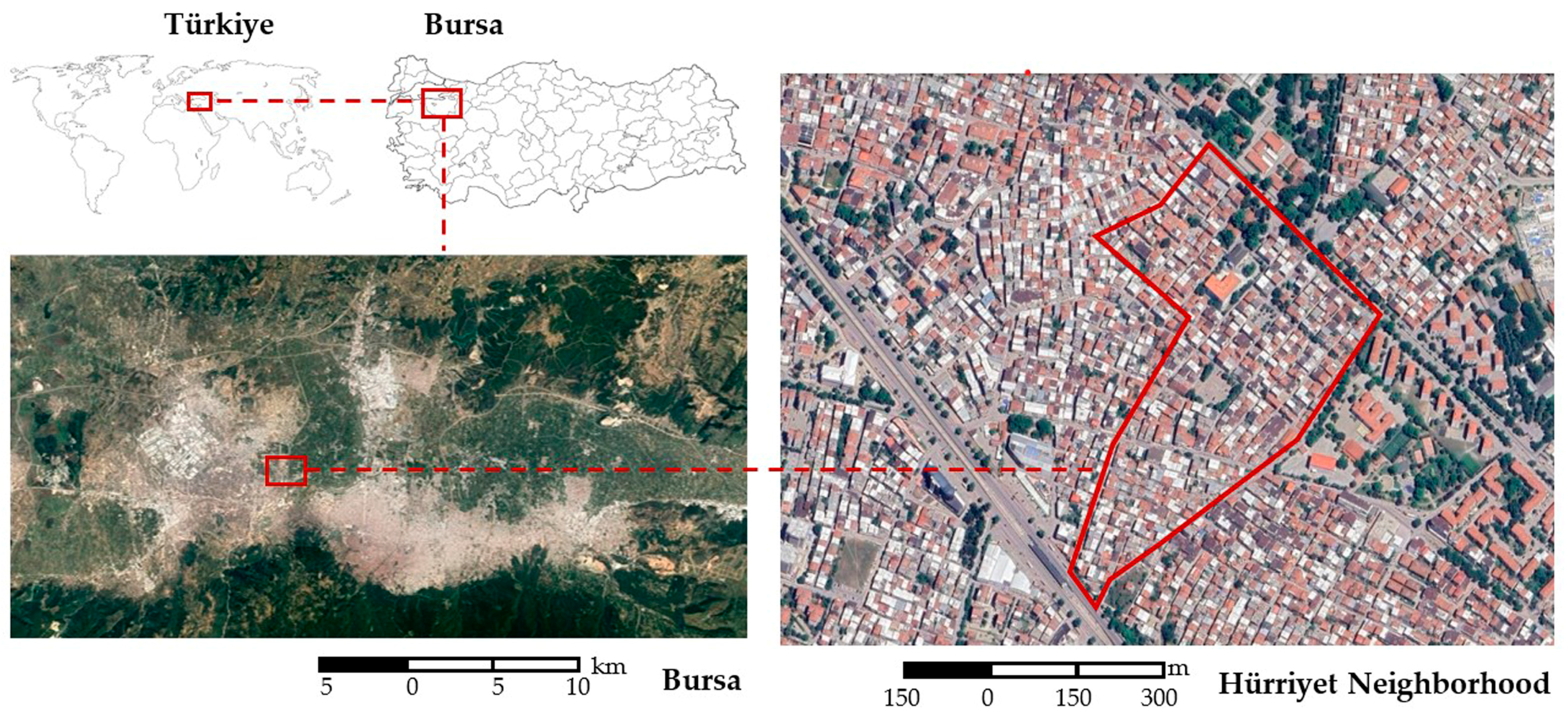
3.1. Bursa-Hürriyet Neighborhood

The Hürriyet Neighborhood located in Bursa was selected for the field study. Bursa is the fourth largest city in Türkiye in terms of population. Along with its history and geographical potential, it is a developing city with job creation due to industrialization, and its population is increasing rapidly with the (internal–external) immigrants it has received. The Hürriyet Neighborhood is one of the neighborhoods in Bursa where Turkish immigrants from the Balkans settled in the 1950s and where new immigrants have arrived over time through kinship and neighborhood ties. The neighborhood is characterized by low-rise buildings, and housing supply is met on a parcel-by-parcel basis [37]. It can be said that it has preserved its general physical and socio-cultural character until now. Therefore, Hürriyet Neighborhood was found suitable for the research due to its local users and neighborhood characteristics.
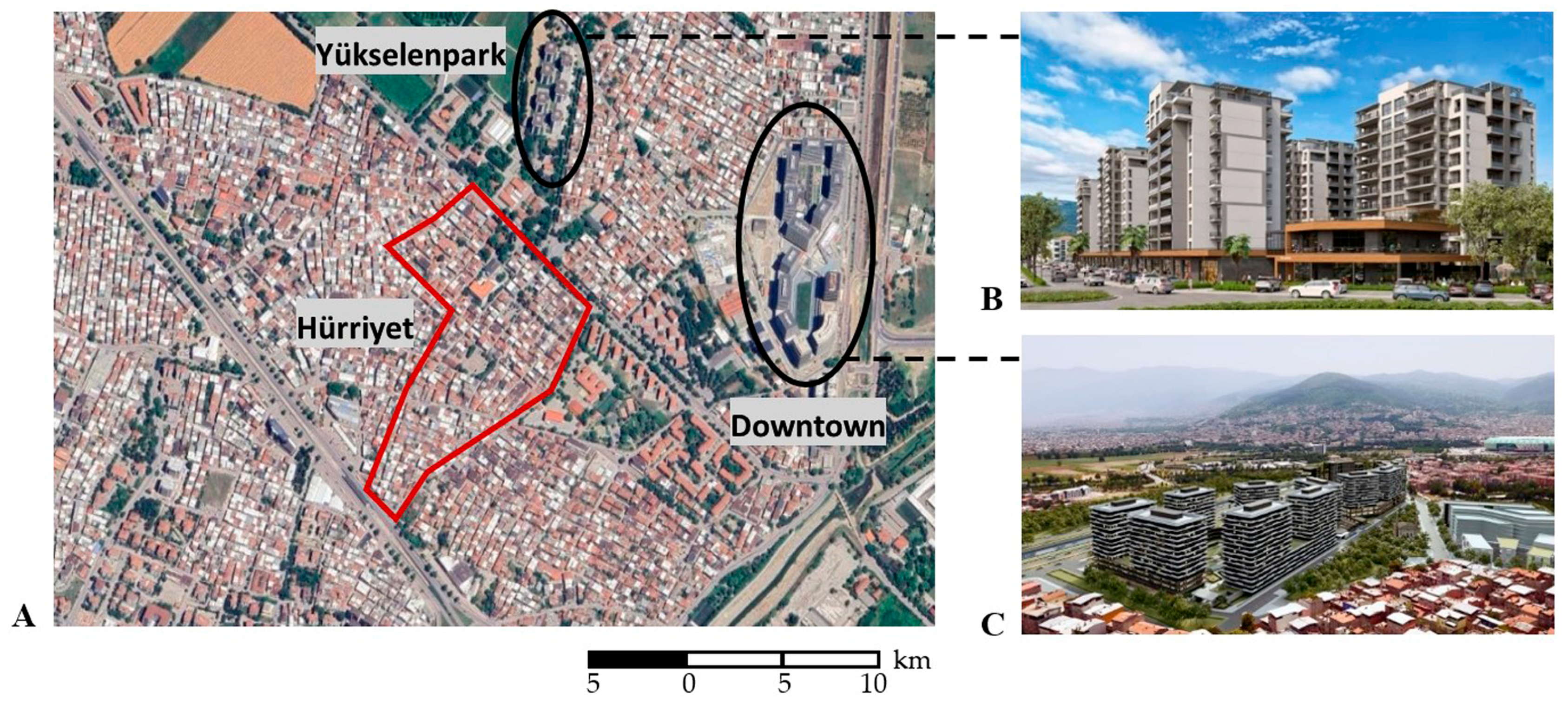
Hürriyet Neighborhood is an old neighborhood close to the Organized Industrial Zone and Sanayi Street (
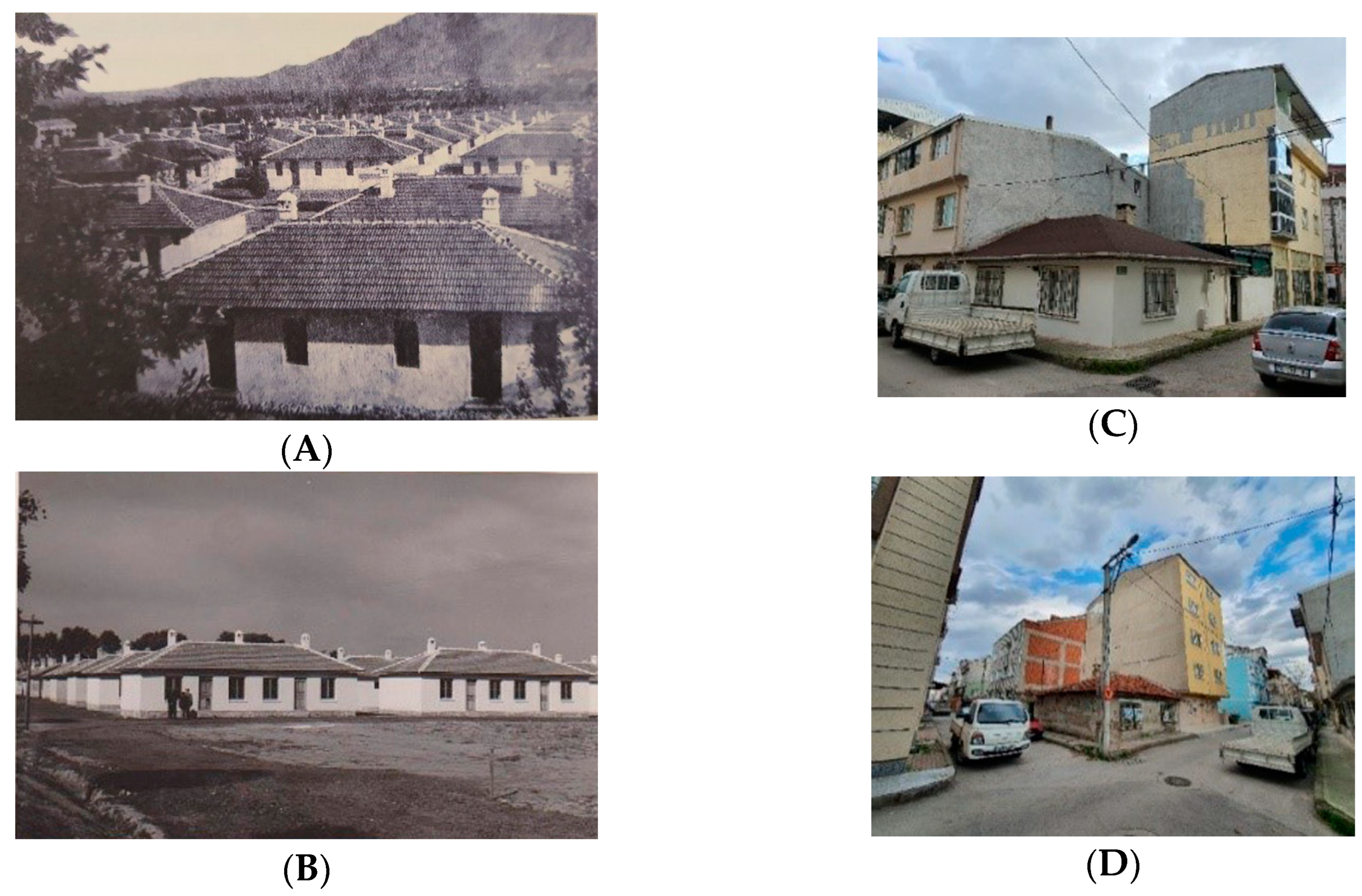
Figure 3). It was established in the early 1950s. In those years, the housing units were built by the state for citizens/relatives of people of Turkish origin (with ethnic structure) who migrated en masse from Bulgaria to Türkiye. Some of these houses, built with a grid plan, single floor, and out of adobe bricks and masonry, continue to exist today (Figure 4). It is recognized as one of the tidiest neighborhoods of Bursa due to its orderly streets formed with grid plan [38].
With the immigration policy implemented after 1950, the people of Turkish origin who came from Bulgaria about every 10 years continued to settle near their relatives or compatriots who had come before [38]. Today, the Hürriyet Neighborhood is a clean, quiet, peaceful neighborhood where the majority of its inhabitants are former Bulgarian immigrants, and the users are happy [38,39]. In the neighborhood, where the social relations are observed to be strong and low-rise construction (3 floors on average) is widespread, new housing unit supply is carried out on the basis of parcels. In general, it can be said that the neighborhood has not changed much and has preserved its physical and socio-cultural character [37]. In the 1960s, urban planning initiations around the city, including the Hürriyet Neighborhood, were implemented, through which parcels were created, accelerating the housing construction. Over time, users have tried to meet their needs with informal/illegal interventions, such as incorporating the garden into the house, adding rooms, or floors, etc. However, this situation has brought quality problems in terms of urban structuring (i.e., strength, layout, aesthetics, identity, etc.).
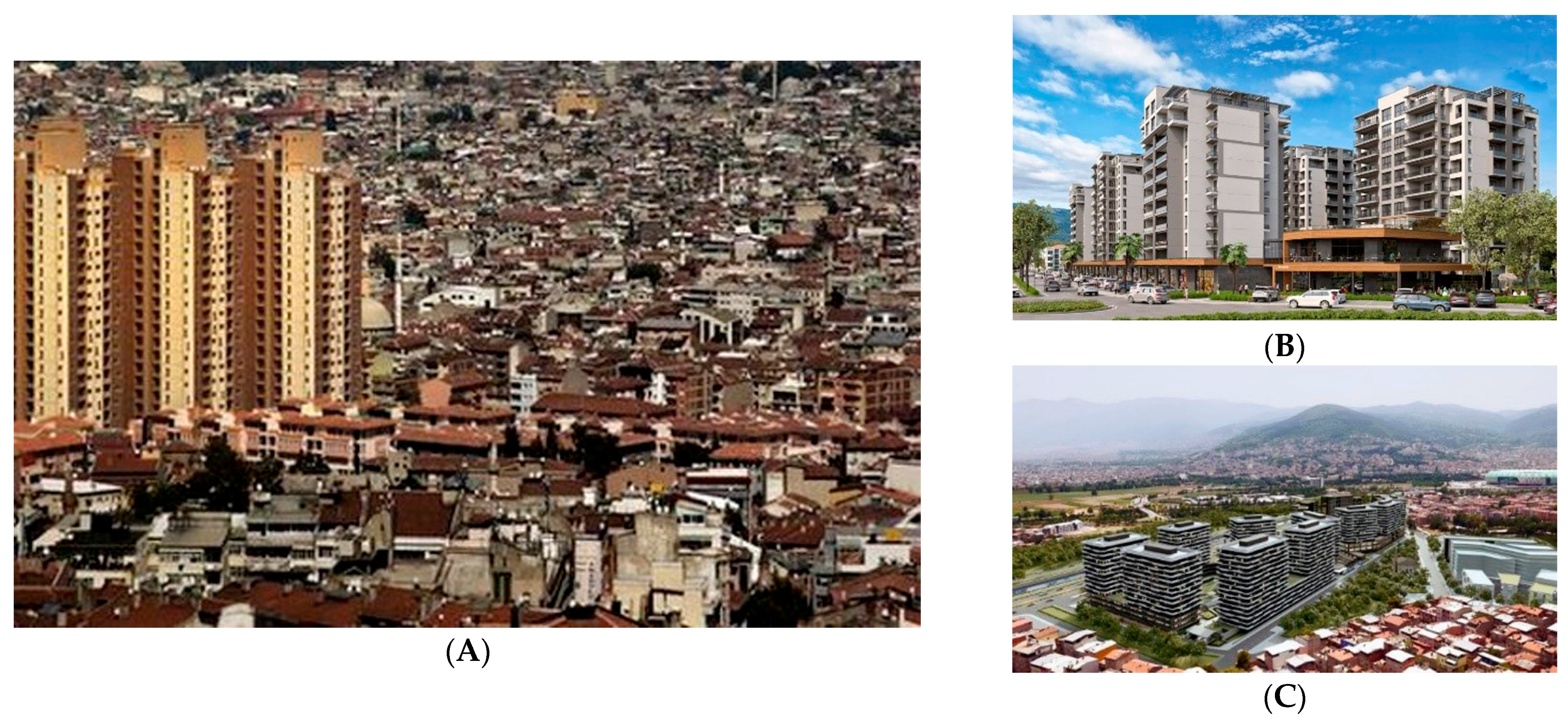
It is observed that the houses in Hürriyet Neighborhood do not rise as much as in other regions of Bursa. One of the reasons for this is that due to the existence of the Yunuseli Airport, which was established in the 1940s, there was a height restriction in and around the Hürriyet Neighborhood until recently. Later, the restrictions were lifted, and the way for high-rise construction was opened in the immediate vicinity (Figure 5A). Another reason the houses in the neighborhood do not rise as much as in other regions is that the existing construction criteria and parcel sizes in the setting are relatively small. However, in recent years, some larger plots in the İstiklal and Adalet Neighborhoods, which were established in the same manner as the Hürriyet Neighborhood, have undergone functional changes. The areas in question have been converted into residential areas, and much taller buildings (approximately 10–15 stories) have been produced (Figure 5B,C). It is expected that this situation will have an effect on the housing market, especially in the surrounding area, create additional pressure on other housing units in terms of conversion, and result in an upward trend. It is foreseen that this scale change in the region will affect social scales as well as physical and economic scales in the future.
  • Questionnaire for Users
The objective of this research’s field study is to identify the priorities and needs of local users in Hürriyet Neighborhood, which has been observed to have strong attachment and social characteristics but has experienced quality loss in the event of the reconstruction of housing. The aim is also to identify the potential of the area and produce results that focus on the utilization of this potential. In the survey conducted in Hürriyet Neighborhood, the environmental qualities of the residence and the neighborhood, user satisfaction, and perception of locality were investigated. The commitment of the existing users to the Hürriyet Neighborhood and how the users perceive the local scale were investigated. The Hürriyet Neighborhood serves as a hub and a commercial center for other nearby neighborhoods.
There are 765 buildings consisting of an average of 3 floors in the Hürriyet Neighborhood. While 723 buildings are being used for residential purposes, 20 of them have been granted construction registration certificates. Building registration certificate: The document to be created for the buildings that have been evaluated within the scope of zoning peace. The building registration certificate is a temporary document issued for the purpose of registering a building that was constructed illegally or in violation of permits before 31 December 2017 and does not provide additional rights in terms of zoning regulations and does not establish any acquired rights. It serves to document the zoning status of the building and its compliance with permits until it is made compliant or undergoes urban redevelopment [42] within the scope of zoning peace. Zoning peace: The practice of registering buildings that are unlicensed or in violation of permits and attachments in an attempt to find a compromise between the state and the citizens as part of preparations for natural disaster risks, referred to as “zoning peace” by the public; it is regulated under the Zoning Law No 3194 [42] regulation with an amendment published in the Official Gazette 2018. Since the municipality only detects illegal structures upon notification and complaint, the number and condition of illegal structures could not be determined (Bursa Metropolitan Municipality, 2022). According to 2020 data, the population of Hürriyet Neighborhood is 4732. One person per household was selected for the survey application. Since the average number of households was 3.5 in Türkiye (in 2020), the population group of the study was calculated to be 1352. In the survey study oriented at the users, a total of 65 participants were evaluated through a 2-month data collection process (October–November 2021), using a random selection method and face-to-face survey application. Due to the difficult conditions and the limited amount of time after the pandemic, 5% of the sample was made up. The questionnaire consists of 5 sections. The survey includes questions about user characteristics, housing characteristics and satisfaction, neighborhood characteristics and satisfaction, outdoor space use, locality, and scale assessment. An open-ended question was posed at the end of the survey. In this study, both quantitative and qualitative research methods were used together. The calculations were made using the Excel program. The reliability of this study was measured using Cronbach’s alpha coefficient, which is appropriate for Likert scale and individual responses, and the value was 0.85. Cronbach’s alpha is considered reliable when it is greater than 0.70 [43].
In this study, while determining the criteria for the scale elements, studies on satisfaction and quality of life, belonging and loyalty, neighborhood, and other social relations at the scale of housing, housing environment, and neighborhood were analyzed. Demographic and socio-economic information was analyzed to determine the characteristics of the housing users. In addition, the age and condition of the housing, second house ownership, and the number of vehicles were questioned, and the economic status and economic conditions of the users were investigated within the scope of the subject. While investigating housing and neighborhood qualities and satisfaction, all criteria were examined, and the criteria that may be directly or indirectly related to local identity, belonging, and scale were determined and focused on the subject [26,44,45,46,47,48,49,50,51,52].
The female–male distribution of users participating in the survey is nearly equal. The majority of the participants are middle-aged or elderly. Although 65% of the participants were born in Bursa, they stated that they were of immigrant origin (Bulgaria). It was found that 77% of the participants have an income of less than TRY 6000, and almost all of them are in the lower-middle income group. Despite this, 78% of users live in their own homes (Table 2).
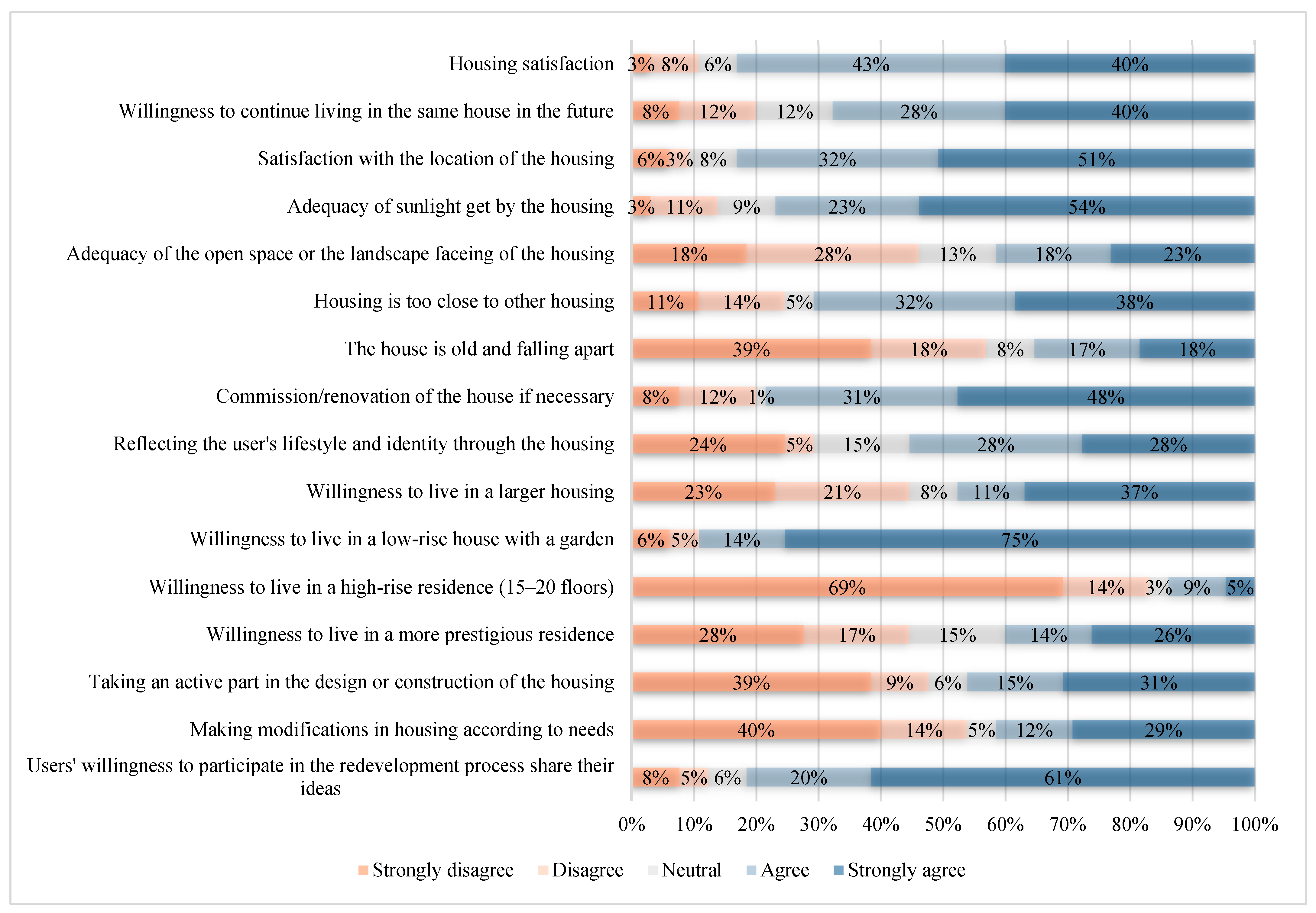
Users are satisfied with their housing (83%) and want to live in the same housing in the future. More than half of the users think that their housing reflects their lifestyle (56%). Almost half of the users want to live in a larger housing unit (48%). The percentage of those who want to live in low-rise housing with a garden is high (89%). However, the percentage of those who express that they want to live in higher-rise (15–20 floors) housing is relatively small (14%), while the percentage of those who want to live in more prestigious housing is remarkable (40%). Almost half of the users have taken part in the design or construction of their home (46%) and have made changes to their home in line with their needs (41%). If housing is to be reproduced, the percentage of those who want to participate in the process and present their ideas is quite high (81%) (Figure 6).
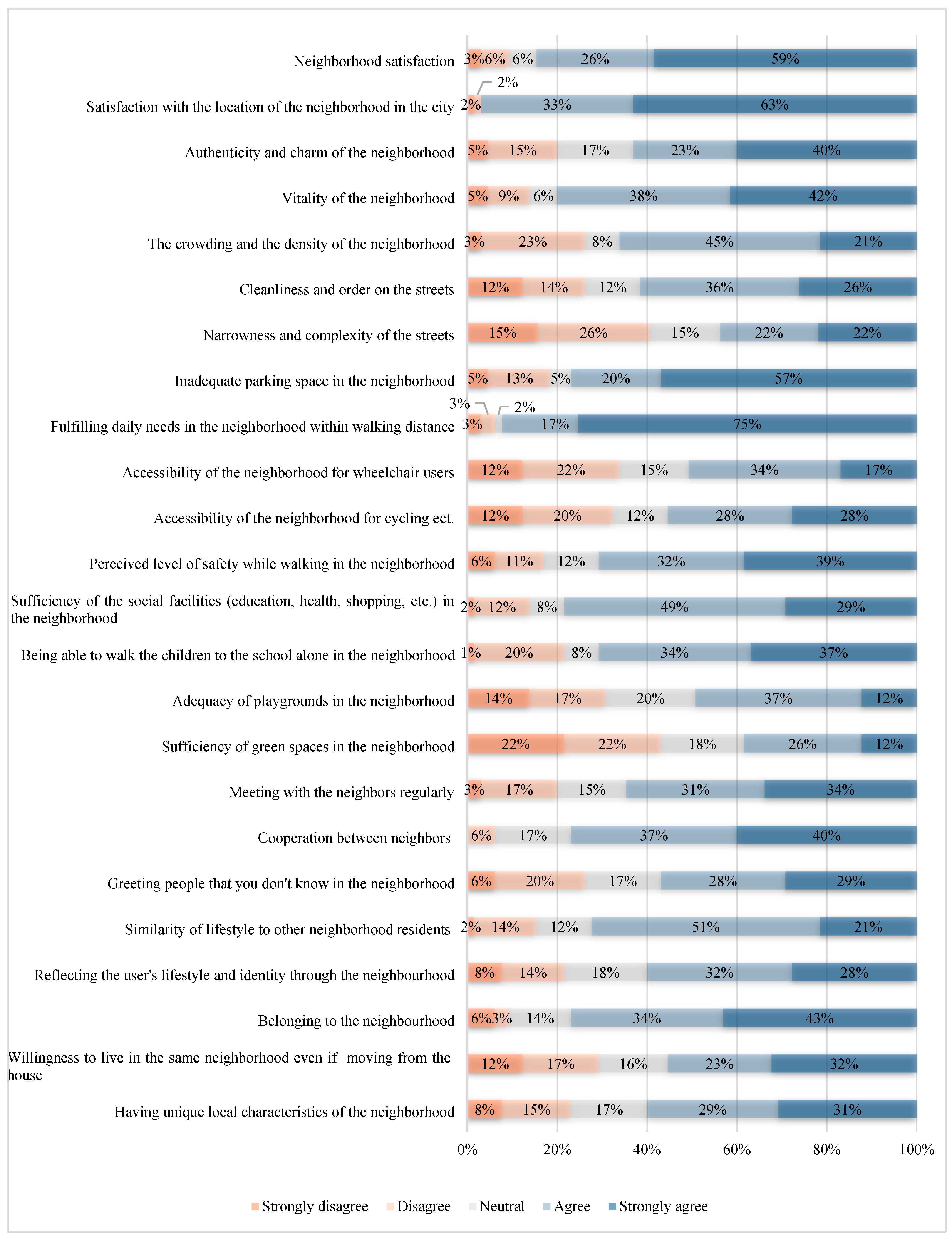
Most of the users surveyed are satisfied with the neighborhood they live in (85%). The location of the neighborhood is quite advantageous in the city (96%). The neighborhood is considered to be authentic and attractive (63%) and, at the same time, lively (80%). It is stated that there is a parking problem (77%). Within walking distance of the neighborhood, daily needs are met (92%), and social facilities (education, health, shopping, religious facilities, etc.) are found to be partially sufficient (78%). Users stated that they meet their neighbors regularly (65%), help their neighbors (77%), and greet people they do not know (57%). Users think that their lifestyle is similar to that of the residents of the neighborhood (73%) and reflects themselves in terms of identity and culture (60%). The majority of users feel that they belong to the neighborhood (77%), and more than half of them want to live in the same neighborhood even if they move out of the housing they live in (55%). More than half of the users think the neighborhood has unique local characteristics (60%) (Figure 7).
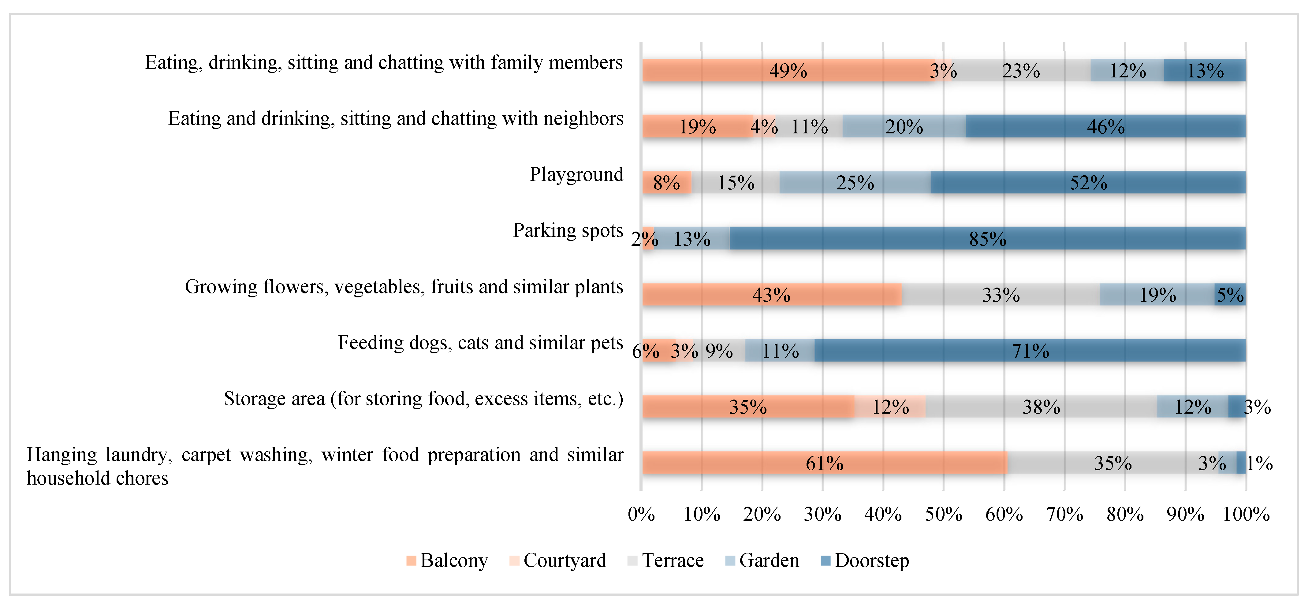
Figure 8 shows the purposes for which users utilize the open and common spaces in residence. It is worth noting that the use of the doorstep area is very common. The doorstep is mainly used for parking, children’s playground, eating and drinking, sitting, and chatting with neighbors. Other open and communal spaces are used quite widely for various purposes.
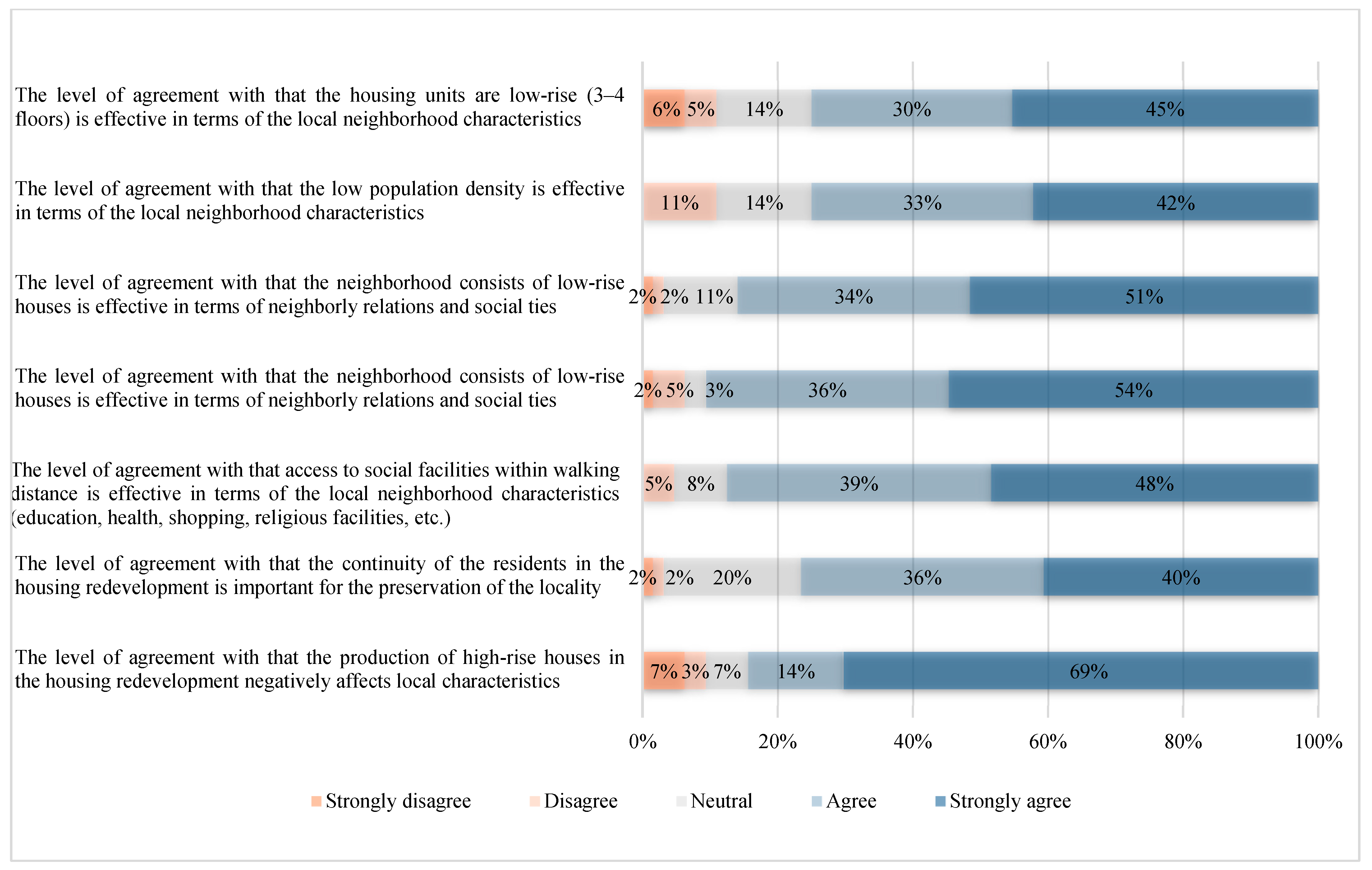
Figure 9 shows that the respondents to the questionnaire have stated that the low number of floors (75%) of the houses in the Hürriyet Neighborhood, the low population density (75%), and the fact that the residents have been living there for a long time (85%) are the main aspects that affect the local character of the neighborhood. In addition, it is observed that the fact that the neighborhood consists of low-rise residential buildings is effective in the formation of neighborhood relations and social ties (90%). This result was associated with the low density and the scale of the residential buildings. It is stated that transportation to social facilities (education, health, shopping, religious facilities, etc.) within walking distance is effective in the formation of the local characteristics of the neighborhood (87%). It is seen that the accessibility and reachability at the horizontal scale in the neighborhood support the liveliness and have an effect on the neighborhood character. Furthermore, it is stated that the continuity of the neighborhood’s residents has an essential role in the continuity of the locality (76%). A large portion of the users think that the production of high-rise residential buildings in the housing redevelopment process will have negative effects on the local characteristics (83%).
  • Questionnaire for Experts
After the Hürriyet Neighborhood field research had been completed, the experts involved in the housing redevelopment processes were surveyed using the Delphi method. The Delphi method is a technique created by Dalkey and Helmer (1963) [53] that allows for identifying the issues on which consensus is reached or not reached among the experts surveyed on a topic. This approach is prominent with the principle of “two views are better than one” and is considered reliable as it allows experts to express their ideas without influencing each other and to freely change their decisions. Basically, there are four features: privacy in participation, repetition, controlled feedback, and statistical analysis.
The Delphi method was implemented during the 3-month data collection period (March–May 2022) and was a result of face-to-face interviews conducted with experts in 3 separate rounds. In round 1, in-depth interviews were conducted with the experts, the data obtained were analyzed, and prominent issues were identified. The opinions of experts on the determined topics were evaluated, and the information obtained through the literature research was also used to create survey questions using a 5-point Likert scale. The prepared questions were directed to experts in the second round. The results of this stage were evaluated, and questions on which a consensus was reached and questions on which a consensus was not reached were determined. In the third round, each expert was provided the opportunity to re-evaluate and change their responses by returning their previous answers along with the overall averages to them. As a result of this round, the criteria on which consensus was reached and those on which consensus was not reached were determined by evaluating the results.
When identifying experts who play an active role in housing redevelopment, attention was paid to the fact that participants are located in Bursa, have previous urban regeneration experience, and have at least 10 years of experience. Although an equal number of men and women were sought, due to the majority of experts who met the criteria being men, equal representation was not possible. A total of 16 participants, consisting of 4 women and 12 men, were included. The characteristics of the expert participants, consisting of designers, contractors, Non-Governmental Organizations (NGOs), and a local administration group, are shown in Table 3.
The study sections using the Delphi method are shown in Table 4. The first round of the survey distributed to expert participants consisted of open-ended questions. Each expert’s response was evaluated, and the prominent criteria were identified and grouped as topics. Arguments related to the criteria under these topics were determined, and the experts were surveyed again, twice, using a 5-point Likert scale.
This study evaluates the priorities section in the final part of the Delphi study that was conducted on the experts. In the priorities section, 16 criteria were determined under 4 titles, and expert participants were asked to rank these criteria according to their level of importance. Only the 3rd round results were evaluated. The top 5 priority criteria for the first 3 titles and the top 10 priority criteria for the last title were evaluated, compared, and interpreted together with the answers of the users of the Hürriyet Neighborhood.

3.1.1. The Causes of Problems in the Housing Redevelopment

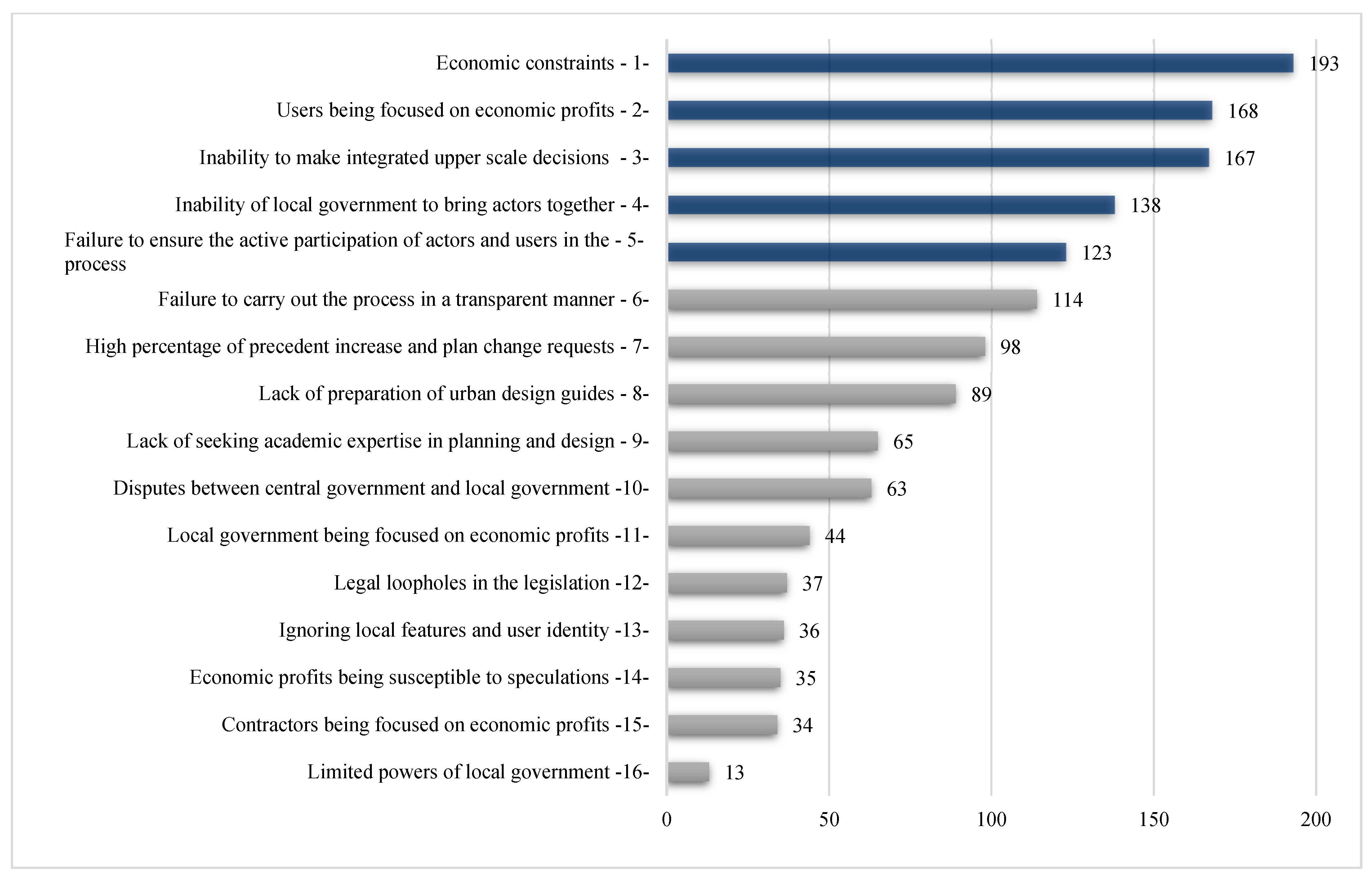
Experts were asked to rank the criteria relevant to the topic according to their order of priority. The most important criterion was given 16 points, and the scoring continued in decreasing order, whereby the criterion not selected was given 0 points. The numbers included in the graphs are the sum of these scores, which are determined by each of the experts for one criterion.
In the priorities section, the first thing expected from expert participants was to rank the causes of the problems encountered in housing redevelopment according to their priorities (Figure 10).
The causes of problems in the housing redevelopment, according to experts:
(1) Economic constraints: Economic effects increase production costs by raising material prices, making it difficult for middle- and low-income users to afford and purchase housing. As housing sales increase, the prices of rental houses also increase, and access to housing gradually becomes more difficult. Starting from the country scale, the economic constraint is an important criterion that affects all other sub-scales.
(2) Users’ expectations are focused on economic rent: Users in the Hürriyet Neighborhood have also complained that developers are profit-oriented. Profit generated in housing production leads to grievances when it is not shared rightly among the actors. According to expert participants, when housing is redeveloped, users should pay the difference in value or settle for a smaller housing unit as the property has gained economic surplus/additional value. The fact that users did not pay any money in some redevelopment projects in Bursa created the same expectation for users in other regions. When the fee or housing size cannot be agreed upon by and between the user and the contractor, the financial resources required for the contractor to start the development work cannot be created. This situation has slowed down the housing redevelopment. To create resources, the local government has granted the right to increase the floor area ratio by 0.50 in some areas, and the scale of housing after the urban transformation has increased by approximately 1.5 times. However, the issue that is usually ignored in this approach is the effect of the economic rent distribution conflict between the contractor and the user on the city and the case of social benefit. The most critical issue affecting the scale of the city is the sharing of economic rent.
(3) Inability to take comprehensive decisions at higher scales: Due to the fact that city plans are roughly created without collecting sufficient data and analysis with current advanced technology, attempts to solve problems happen later on the fly and with short-term resolutions.
(4) Local administration’s inability to bring actors together in the right way: Local administration is expected to create a viable model by assuming a certain type of regulatory role (i.e., game planner) and function as an arbitrator. The contractors, in particular, are critical of the local administration’s role in the market as a developer of its own, competing with the private sector. On the other hand, through this way, the housing prices in the market can be kept under some kind of control by the local administrations.
(5) Failure to ensure effective participation of actors and users in the process: What is expected from effective participation is that, in addition to determining the standard of living, habits, local characteristics, user needs, and wishes, users should play a role in the design and assume an active role in the decision process.
According to experts, the criterion “local characteristics and disregard of the user identity” ranked 13th among the problems experienced in the housing redevelopment, which is quite far behind. This either indicates that the experts who take an active part in the housing redevelopment do not have adequate sensitivity towards maintaining the local characteristics of the neighborhoods, or it shows that other values are prioritized before preserving the local characteristics.

3.1.2. The Necessary Criteria for Ensuring Social Sustainability from the Users’ Perspective

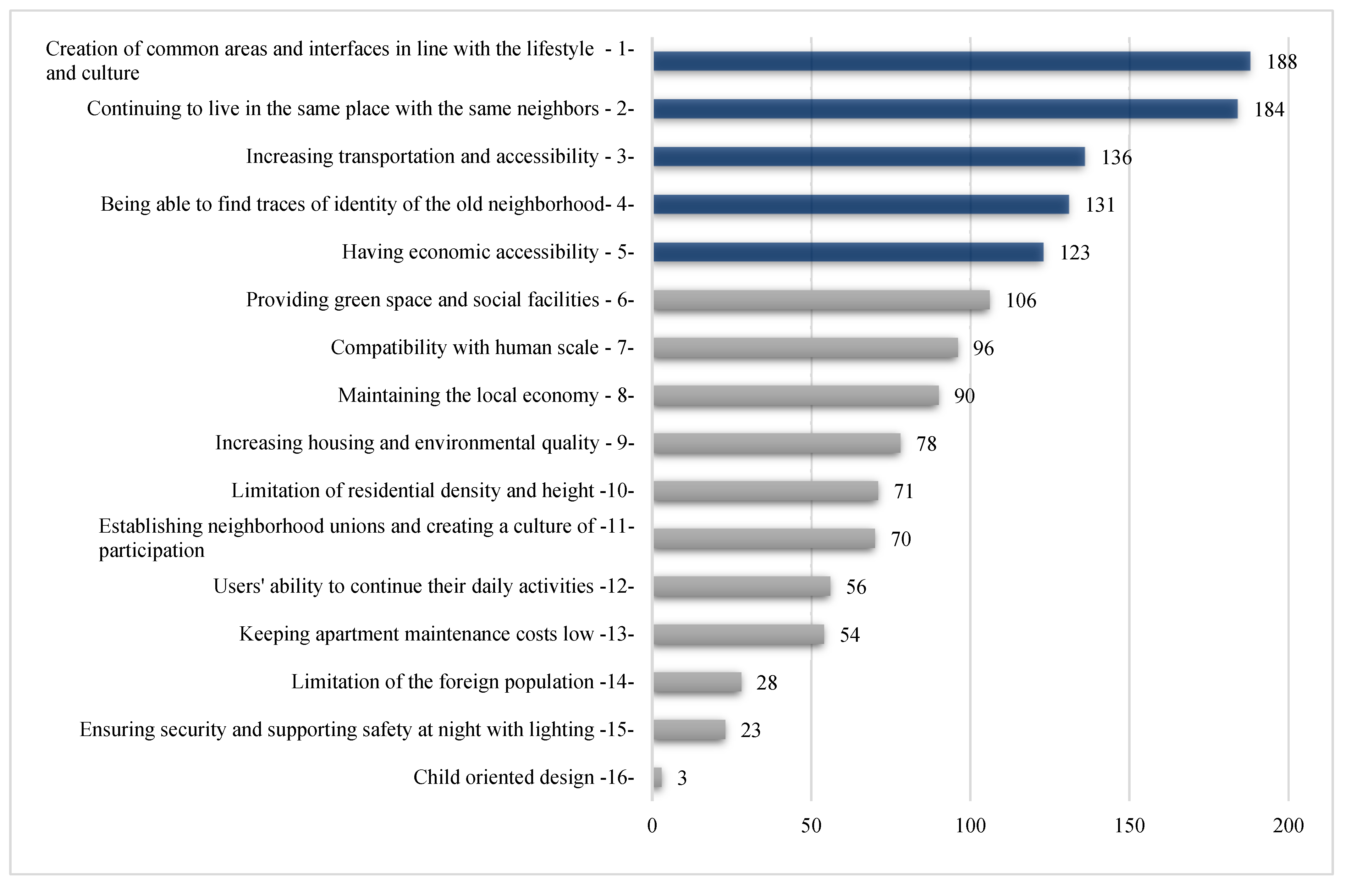
In the priorities section, the second thing expected from expert participants was to rank the criteria necessary for ensuring social sustainability from the user’s perspective according to their priorities (Figure 11).
According to experts, the priority criteria for ensuring social sustainability from the user’s perspective are as follows:
(1) Creating common spaces and interfaces in a proper manner for the living culture: It is observed that the use of open and shared spaces (i.e., doorstep, garden, courtyard, terrace, and balcony) is widespread among the users in the Hürriyet neighborhood (see Figure 8). Especially in settlements where the climate is mild and the users are culturally familiar with the street, it is important to create common areas and interfaces to ensure social sustainability.
(2) Continuing to live in the same place and with former neighbors: Users think that the continuity of neighborhood residents is important for the continuation of locality in the housing redevelopment (75%) (see Figure 9). The state of being neighborly and familiar in old and established neighborhoods is also considered valuable by experts. For the continuity of the locality, the existence of the current user must be preserved.
(3) Increasing transportation and accessibility opportunities: Users in the Hürriyet neighborhood have expressed that the location of the neighborhood within the city is advantageous (97%), and public transportation is sufficient. Users have stated that vehicles are dense, and there is a shortage of parking spots in the neighborhood (77%). About half of the users responded positively to the suggestion that the neighborhood they live in is suitable for bicycle use (56%) and the suggestion that the neighborhood they live in is suitable for stroller and wheelchair use (51%) (see Figure 7). The Hürriyet Neighborhood has a flat topography; thus, it is suitable for cycling. Bicycle use is also widespread in the cultural/habitual sense. However, it is necessary to rearrange narrow streets and sidewalks, create bicycle paths and signs, and make floor materials suitable for accessible transportation (Figure 12). According to experts and users, increasing transportation and accessibility opportunities is essential for social sustainability.
(4) Users being able to find traces of their identity and former neighborhood: Users in the Hürriyet Neighborhood also think that the neighborhood reflects them in terms of identity and culture (60%), their lifestyle is similar to other neighborhood residents (72%), and the neighborhood has unique and local characteristics (60%) (see Figure 7). Users have described these local characteristics as follows: the Hürriyet Neighborhood is calm, safe, clean, and tidy; the neighbor relations and cooperation between the residents remain; and the social relations are strong. In addition, the use of low-rise houses, gardens, and terraces is widespread, and certain cultural habits continue, such as winter food preparation at home, etc. The green areas around the neighborhood (agricultural and recreational areas) are considered valuable. It has been stated that squares named after state officials and used as meeting places that carry spiritual meaning should be preserved within the neighborhood. It has also been emphasized that the function of the commercial axes that are widely used should be preserved in order to continue social behaviors and living habits. Keeping the social memory alive and transferring some local features to the new settlement was considered important by both experts and users in terms of social sustainability.
(5) Economic accessibility: In particular, unaffordable apartment maintenance fees and rental prices cause users to leave their residential units, which is seen as an existential problem in ensuring social sustainability.

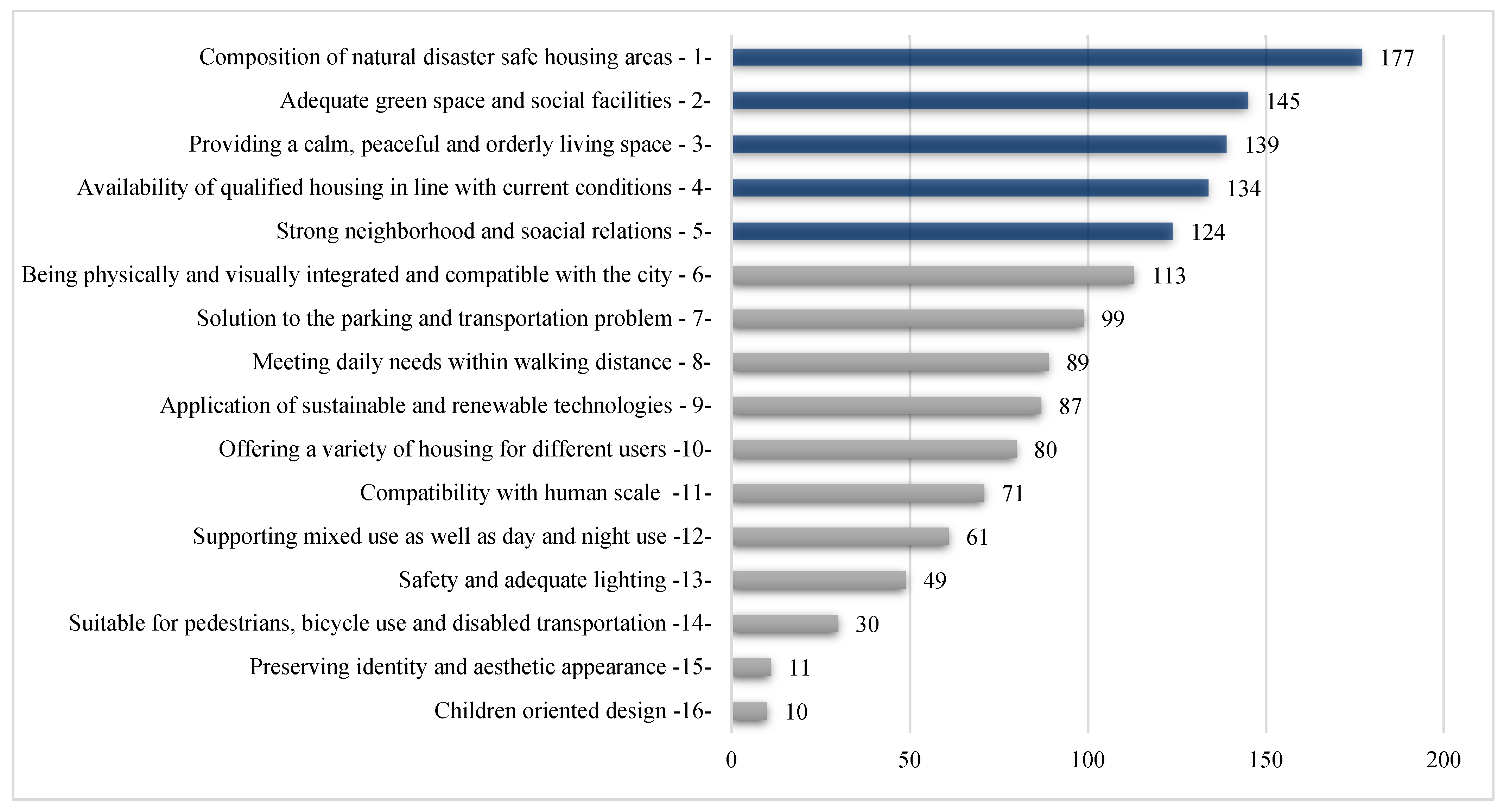
3.1.3. Features That a Neighborhood Unit Should Have after Housing Redevelopment

Thirdly, the expert participants were asked to rank the criteria defining the characteristics that a neighborhood unit should have after housing redevelopment (Figure 13).
Features that a neighborhood unit should have after housing redevelopment:
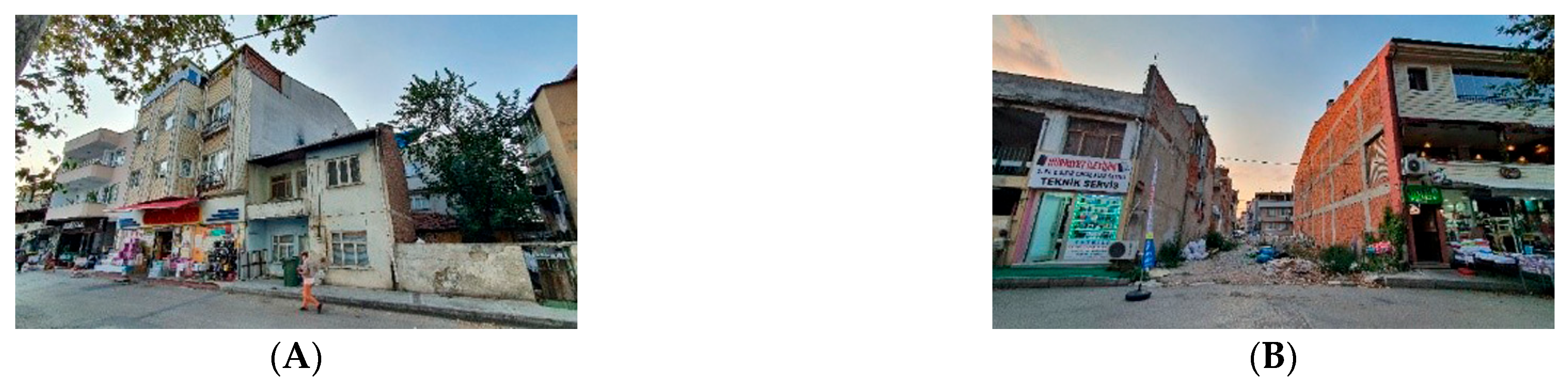
(1) Disaster-safe housing areas: A portion of users in the Hürriyet Neighborhood have stated that they have made modifications to their housing according to their needs (41%). Although it is seen that housing modifications yield changes within the interior and result in illegal interventions, such as building additional floors, the data on illegal constructions is insufficient. After the Great Marmara earthquake of 1999, zoning regulations were updated, and new rules for structural safety were established. Recently, it has been observed that users have redeveloped their residences at the parcel level by reaching agreements with various contractors. It can be assumed that these structures were built according to the new legislation and are safer in terms of natural disasters. The presence of old, inferior-quality housing and crumbling areas in the Hürriyet Neighborhood that were built prior to 1999 without any input from architectural and engineering services makes the redevelopment of housing necessary (Figure 14).
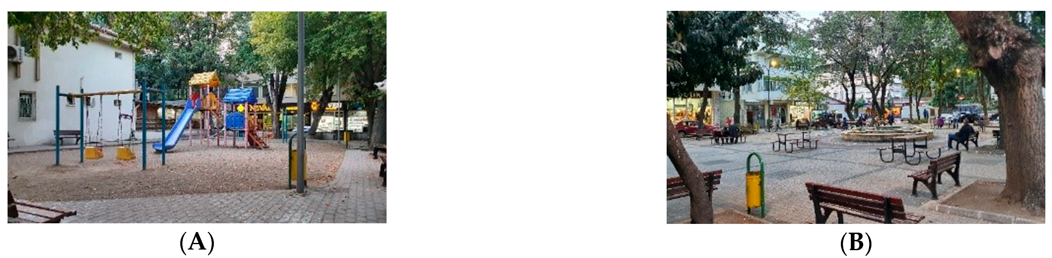
(2) Sufficient green spaces and social facilities: One of the biggest problems in our cities, where population and housing density are increasing, is the insufficiency of social facilities such as qualified green spaces, recreational facilities, schools, and health centers. The users in Hürriyet Neighborhood are of the opinion that the social facilities in the neighborhood (i.e., educational facilities, health centers, shopping malls, prayer rooms, etc.) are sufficient (78%). It has been verbally stated that the health sector is considered inadequate. The percentage of those who think that there are enough children’s playgrounds (49%) and enough green spaces (38%) in the neighborhood is quite small (see Figure 7). Since the only children’s playgrounds and recreational areas (Figure 15A,B) in the neighborhood are insufficient at the neighborhood level, other parks and recreational areas in nearby neighborhoods are used in most cases.
(3) Providing a calm, peaceful, and orderly living space: The percentage of users in the Hürriyet Neighborhood who think that the neighborhood is lively and energetic (80%) and those who think that the neighborhood is dense and crowded (67%) is higher (see Figure 7). The reason for this density is that many people from the surrounding areas visit the Hürriyet Neighborhood to shop at the stores and use the social facilities in the neighborhood. The percentage of those who responded that they can meet their daily needs within walking distance in the neighborhood where they live (92%) is quite high. There is a high percentage of users who feel safe walking around the neighborhood (70%) and those who say that children can walk to school alone (71%) (see Figure 7). The perception of security in the neighborhood is high, and the crime rate is low. It argued that a complex, noisy, unsafe, and stressful life continues in areas where neighborhoods host an increasing number of immigrants, especially in areas where low-income groups live and illegal construction is intense. Since it is the fundamental right of every urban person to live in healthy and high-quality environments, improving these conditions is important for ensuring the health and well-being of the urban population.
(4) Production of housing that is suitable and of good quality to current conditions: Especially in neighborhoods that have existed for a long time, the houses may lose their structural integrity over time and become unable to meet the needs of today, even if they were initially produced with architectural and engineering services according to the conditions of the time; therefore, it is necessary to rebuild them. On the other hand, it is indisputable that illegal structures built without technological production, legal regulation, or supervision should be renewed. Among the users of the Hürriyet Neighborhood, the percentage of those who say that their housing unit is old and crumbling down (35%) is remarkable. The percentage of those who say that they have made or commissioned maintenance or renovation works in the housing unit they live in when necessary (79%) is high. The percentage of those who say that they have taken active part in the design or construction of the housing they live in (46%) and those who say that they have made modifications to their housing unit according to their needs (41%) is important (see Figure 6). It is seen that the users in the Hürriyet Neighborhood have adapted their housing units.
(5) Strong neighborhood and social relations: Users in the Hürriyet Neighborhood regularly meet with their neighbors (65%). Those who help their neighbors constitute 77%, and those who greet strangers in the neighborhood constitute 57% (see Figure 7). Neighborhood and other social relations create a sense of security and strengthen the sense of belonging and loyalty to the neighborhood.

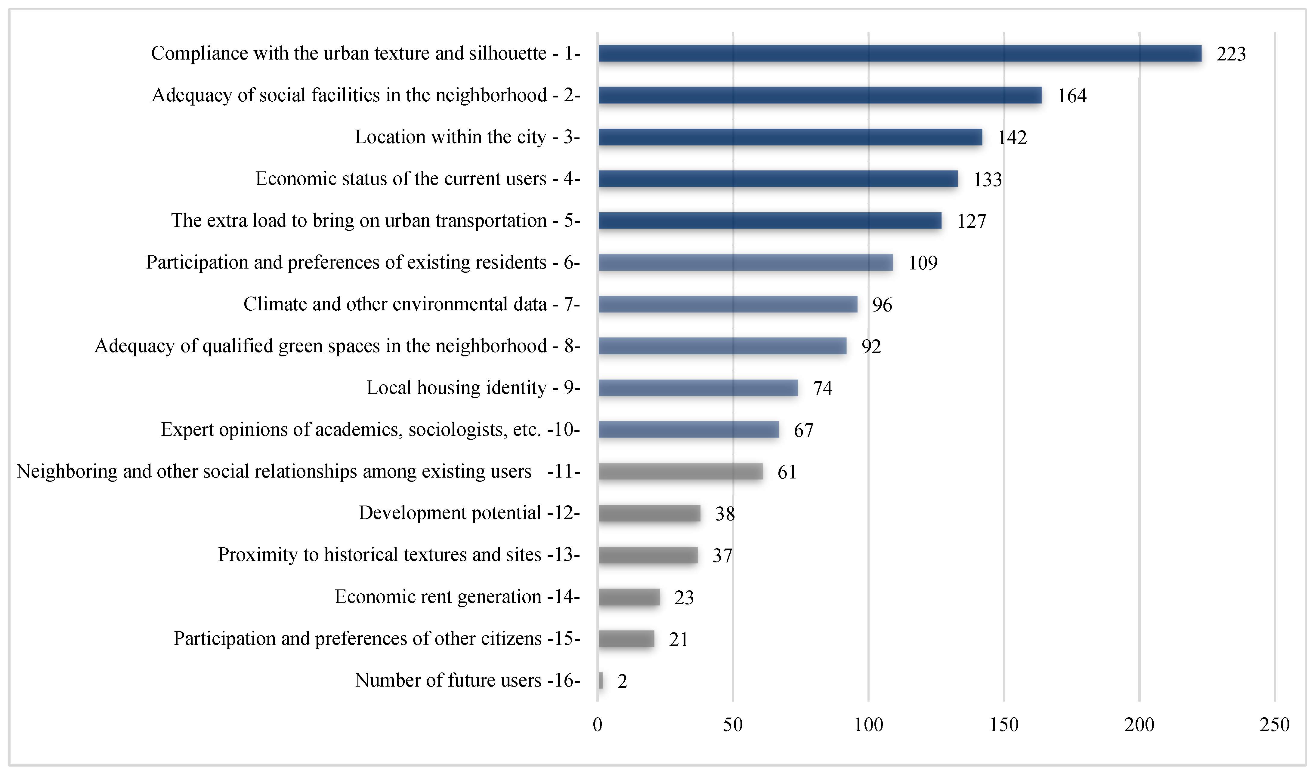
3.1.4. Strategic Approach to Determining the Scale of Housing (Physical–Social–Economic) in the Housing Redevelopment

Fourthly, the expert participants were asked to rank the criteria that should be taken into account in creating a strategic approach for determining the scale (physical–social–economic) of housing redevelopment in terms of priorities when developing (Figure 16).
According to experts, the priority criteria for determining the scale in the housing redevelopment are as follows:
(1) Conformity to urban texture and silhouette: In this study conducted on the scale of Bursa, it can be argued that Bursa’s prior urban transformation experiences (for example, Doğanbey TOKI) have had quite an impact in prioritizing this criterion (Figure 17A). The users of Hürriyet Neighborhood do not want to live in a higher-rise residential building (15–20 floors) (83%); they want to live in a low-rise residential building with a garden (89%) (see Figure 6). The percentage of those who think that the low-rise buildings (3–4 floors) are effective in forming the local characteristics of the neighborhood (74%) is remarkable. It is believed that the production of high-rise residential buildings in the housing redevelopment will negatively affect local characteristics (83%) (see Figure 9).
(2) Adequacy of social equipment areas in the neighborhood: Residents of the Hürriyet Neighborhood think that access to social facilities (i.e., education, health, shopping, mosque, etc.) within walking distance is effective in forming the local characteristics of the neighborhood (86%). On the other hand, the lack of health and education institutions and similar social facilities in the neighborhoods causes social inequality. It forces those who want to access these services from other places to bring additional traffic load to the city.
(3) Location in the city: It is thought that the location will be decisive regarding its effect on the silhouette and the extra density it will bring to the environment. It is thought that the location of the Hürriyet Neighborhood within the city is advantageous (84%) (see Figure 7). Additionally, the users express that they are satisfied with the location of the housing they live in (83%) (see Figure 6).
(4) Economic status of the current user: In determining the scale of housing, it is necessary to perform an in-depth analysis of the economic conditions, living standards, and social status of the user. Hürriyet Neighborhood users are generally lower-middle income earners. Even if they move out of the house they live in, they express that they want to live in the same neighborhood again (55%) (see Figure 7) and that they do not want to live in higher houses (83%) (see Figure 6).
(5) The extra load it will bring on urban transportation: The percentage of users (77%) who say that there is a high vehicle density and a shortage of parking spots in the Hürriyet Neighborhood is high. In the current situation, increasing the population and traffic density in regions where the density is already high is undesirable. In this case, alternative means of transportation should be provided, or a model that encourages the reduction of density should be proposed.
(6) Participation and preferences of existing housing users: If housing is to be redeveloped, the number of users who want to participate in the process and present their ideas is relatively high (82%) (see Figure 6). Effective participation of users in all decision making and design processes provides transparency; increases trust, satisfaction, and a sense of belonging; and facilitates the achievement of accurate results. By participating in the determination of the scale, typological diversity can be created according to the preferences of the users, and monotypization/homogeneity can be prevented by creating mobility in accordance with the silhouette.
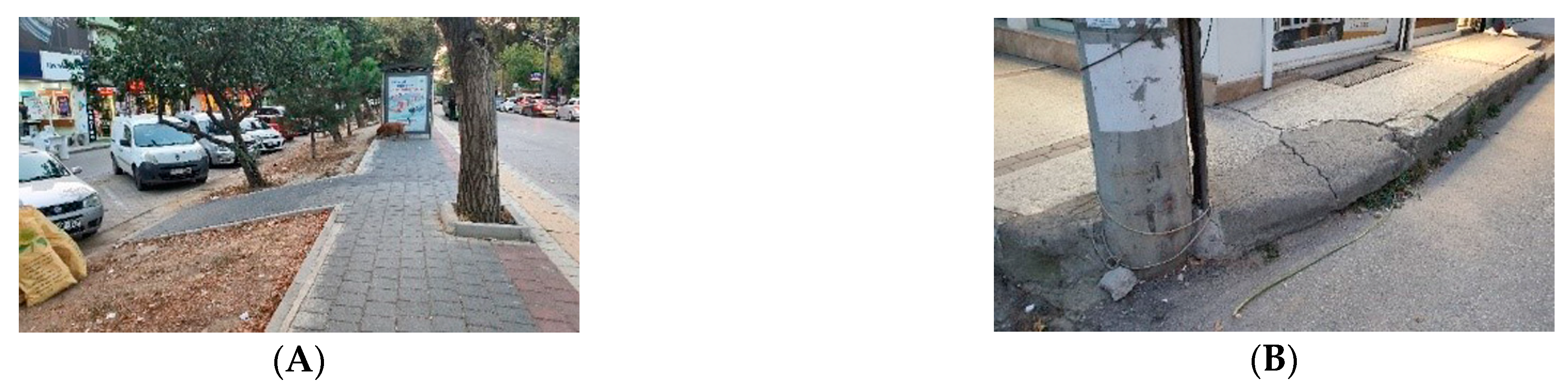
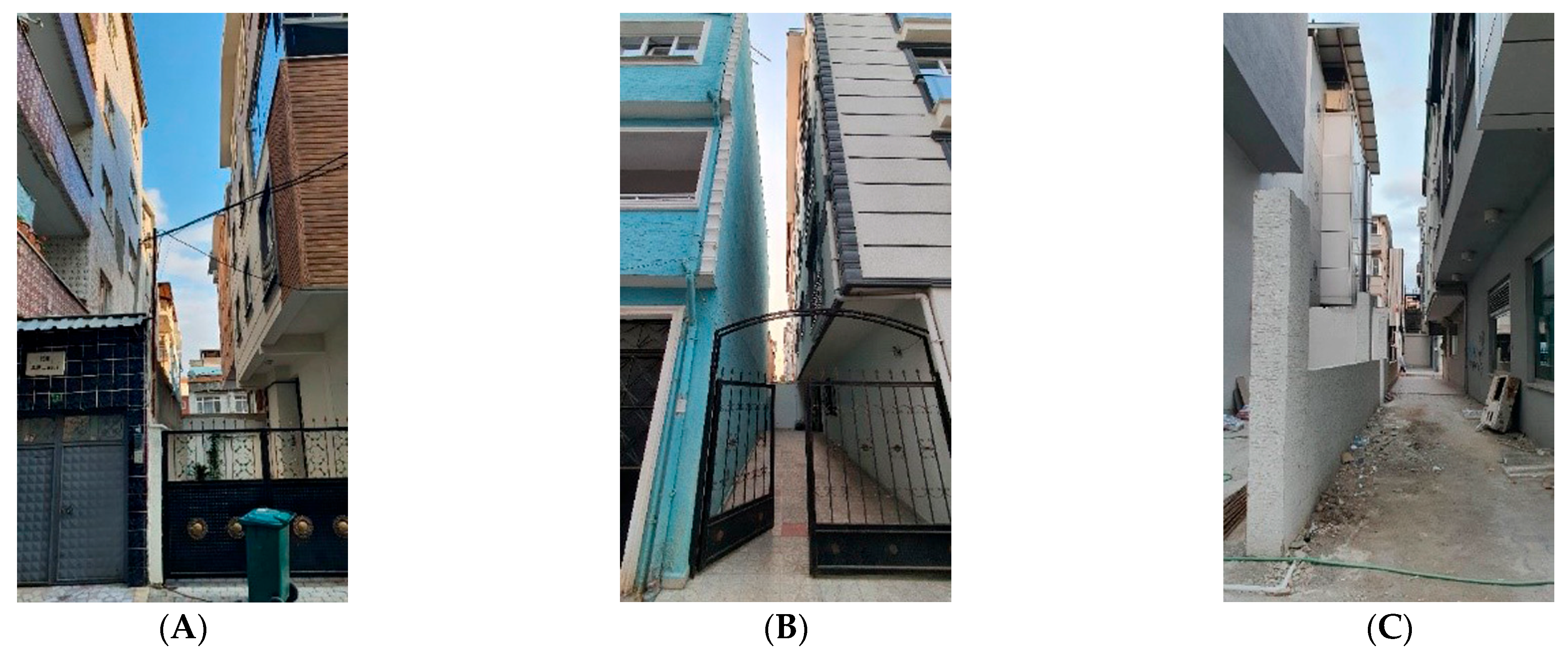
(7) Climate and other environmental data: It is necessary to evaluate essential issues such as maintaining natural air flows in the city, circulation of clean and dirty air, formation of wind and rain, and temperature increase in collaboration with experts. The fact that there are more users (77%) in the Hürriyet Neighborhood who say that their housing units receive enough sunlight is associated with the fact that the houses have few floors. However, the number of those who think their residential unit is too close to other residences (70%) is also high. The reason for this is the creation of facades very close to each other by renovating on a parcel basis (Figure 18A–C).
(8) Adequacy of qualified green spaces in the neighborhood: As the population and housing density increase, the ratio of qualified green spaces per capita decreases. However, in the areas where housing redevelopment is carried out, there is also the destruction of the natural environment along with the existing building environment. When we look at the city of Bursa, which used to be called “Green Bursa”, with a satellite image, it can be argued that qualified green areas are particularly rare, except for large urban parks, and that they do not meet the need on the neighborhood scale (see Figure 3).
(9) Local housing identity: Users in the Hürriyet Neighborhood think that the neighborhood has unique and local characteristics (60%) (see Figure 7). The notable characteristics of housing in Hürriyet Neighborhood are described as follows: low-rise buildings; living with relatives and shared use of common areas; widespread use of open and semi-open interfaces such as gardens, courtyards, terraces, balconies, and doorsteps; and widespread cultivation of plants such as vines and flowers and provision of space for them within the housing. Cultural habits such as winter food preparation and the need for storage and preparation space are among the common features. The term “local housing identity” refers to the production of spaces that will ensure the continuity of unique features that are formed by the use and preferences of local users and that differentiate the area from other locations. In rapidly changing and immigration-heavy cities, it is necessary to aim for the redevelopment of housing by combining the continuity of the sense of place and belonging in these old neighborhoods, which are few in number, and the unique local features and current conditions of the local housing.
(10) Expert opinions by academics and sociologists: In the study, in-depth interviews conducted with experts have focused on the example of the Doğanbey TOKİ urban transformation project in Bursa. It has been pointed out that the results would have been different if the expert opinions had been taken into account in the process. Expert opinions should be included in the housing redevelopment process.

4. Discussion

As identified in the study, the scale-related sensitivities of the users in the Hürriyet neighborhood are physically oriented towards the preservation of the local texture and character. Socially, they are in favor of maintaining neighborhood and other social relations, a sense of security, and a sense of place and belonging. The most important priority of the experts regarding the neighborhood scale is the adequacy of social facilities (2/16). The participation and preferences of existing users (6/16), the adequacy of green spaces (8/16), and local housing identity (9/16) are less prioritized. One of the important findings of this study is that contrary to the sensitivity of users, the existence and continuity of neighborhood and other social relations (11/16) are not seen as a high priority by experts. To discuss the issue in terms of applicability at different scales, it is seen that the large-scale, high-density, and gated community forum of the new housing projects close to the Hürriyet neighborhood, which are implemented at the block scale, contradicts the existing local texture and character, and is incompatible with the physical scale (see Figure 17B,C). For the Hürriyet neighborhood and other neighborhoods with similar characteristics and a high sense of belonging, parameters such as neighborhood vitality, street life, walkability, sense of security, and sense of place are affected (directly or indirectly) by the scale, and the appropriate scale supports the quality of life in the neighborhood. This study concluded that as the scale compatibility decreases, the effect of these parameters on the formation of belonging will decrease, and therefore, these parameters should be taken into consideration in design and planning. In addition, it is noteworthy that both projects do not comply with the socio-economic qualities of the neighborhood users (4/16), which is seen as a priority by experts. It is thought that this situation will affect the quality of future housing and encourage luxury housing and gated communities. It is predicted that economic and physical incompatibility will bring social incompatibility with it.
In this study, the most important parameter that the experts focused on in determining the scale was the suitability of the city silhouette. It is clear that the disadvantage caused by the Bursa Doğanbey TOKİ urban transformation project, which was completed in 2012, on the skyline is effective in this result. In terms of applicability at larger scales, Bursa Doğanbey TOKİ urban regeneration project, which has been widely mentioned by both users and experts, can be cited as an example (see Figure 17A). In this project, which has different local characteristics and a larger scale than the other examples (four neighborhoods merged), it was emphasized by the experts that a transparent participation model should be applied, involving experts and users as well as other city residents, instead of centralized decisions (top-down) while still in the planning phase. It is argued that if it had been implemented in this way, a high-density and large-scale construction (24 buildings with 23 floors side by side), visible from all over the city, where users do not know each other, where neighborhood and social relations cannot be established [54], could not be built in the center of Bursa, which has historical and cultural richness. In the research that was conducted in this area before the transformation, it was stated that there were security problems, but there was still a high level of neighborhood and social relations in the neighborhood, and this was lost after the transformation; social facilities were insufficient, users could not get used to living in a very high-rise building, and they longed for their previous houses with gardens.
In addition, the project has been criticized in terms of urban conservation and sustainability due to the distancing of the historical texture from the historical city identity with the construction of high-rise residences, economic rent-oriented investments, and disregard for public benefit [54]. Taking this study as a reference, the site-specific participatory and collaborative model proposed in the article can be applied in different cities and at different scales in terms of applicability to future developments, where the parameters that will determine the scale will also differ according to local unique qualities, and to identify and prioritize these new parameters. The level of contribution of participants in housing redevelopment should be discussed in terms of financing, level of knowledge, and expected outcomes of participation. For example, whether users are willing to pay additional costs for housing production will affect the pace and scale of the process. Therefore, economic viability and accessibility should be ensured, and the adaptation process should be planned so that housing does not turn into a rental element after production and users are prevented from voluntarily or compulsorily selling their houses and leaving the neighborhood.
This study reveals that scale is important in the formation of locality in the neighborhood, in which the physical scale of the houses that make up the neighborhood affects the social scale, and that users should participate with experts in determining the scale of the local housing redevelopment process.

5. Conclusions

Under the influence of globalization, cities are undergoing rapid change, and physical and social changes are observed, as well as economic changes. Particularly in developing cities and immigrant regions, the value of urban space is constantly increasing, and the urban image is evolving towards high-rise construction. Therefore, the unique distinctions of locality are eroding and disappearing. Although it is stated that the local government, which has the authority to determine the scale of housing production, produces results based on user surveys and field research, the focus is still on quantitative data such as density calculation or the increase of the previous ratio. The human dimensions of the scale, such as perception, behavior, needs, and elements that define the relational quality and context of the immediate environment, are insufficient/not taken into account. In this case, not only do building density, population density, and traffic density increase but also the meaning and relevance of local authenticity change and diminish.
Based on the data obtained, this paper shows that reversing the top–down management system for determining the scale of housing production can lead to different outcomes in physical, social, and economic dimensions that are often overlooked by experts. The active participation of the users, who are familiar with, use, and feel responsible for the entire neighborhood and the immediate surroundings of their residences, as the stakeholders who will be directly affected, enables the identification of unique neighborhood characteristics in the process of determining the scale and supports the continuity of belonging. Therefore, collaborative and participatory management processes should be adopted to ensure social sustainability and a sense of belonging. Goals should focus on determining scale by taking into account the unique qualities of the place and preserving the locality. In urban planning, it is necessary to determine the unique values of the neighborhood through participation, to include cultural and identity elements that have formed over time, and to evaluate socio-spatial potentials. Urban planning should aim for a value-oriented, public benefit-oriented, and locally appropriate housing reproduction that aims to preserve urban memory and the continuity of social life. By combining quantitative and qualitative data, this study argues for a “glocal approach” to housing regeneration that adapts to the specific needs and characteristics of each city and neighborhood.

Author Contributions

Conceptualization, S.E., N.T. and M.T.; methodology, S.E., N.T. and M.T.; validation, N.T. and M.T.; formal analysis, S.E. and N.T.; investigation, S.E.; resources, S.E.; data curation, S.E.; writing—original draft preparation, S.E.; writing—review and editing, N.T. and M.T.; visualization, S.E.; supervision, N.T. and M.T.; project administration, N.T. All authors have read and agreed to the published version of the manuscript.

Funding

This research received no external funding.

Institutional Review Board Statement

All subjects provided their informed consent for inclusion before they participated in this study. This study was conducted in accordance with the Declaration of Helsinki, and the protocol was approved by the Ethics Committee of Bursa Uludağ University Research and Publication (2021-08/4 and 2022-02/2).

Informed Consent Statement

Informed consent was obtained from all subjects involved in the study.

Data Availability Statement

Data are contained within the article.

Acknowledgments

Thanks are given to all official institutions and the expert participants, including architects, urban planners, engineers, contractors, and public and NGO employees, whose names I could not write due to the research method I used in my thesis, for taking the time to share their opinions and thoughts sincerely and for their hospitality and assistance.

Conflicts of Interest

The authors declare no conflict of interest.

References

  1. Tosun, E.K. Küreselleşme Sürecinde Kentlerde Mekânsal, Sosyal ve Kültürel Değişim: Bursa Örneği. Ph.D. Thesis, Uludağ University, Bursa, Türkiye, 2007. [Google Scholar]
  2. Bilsel, S.G. Kent Kültürü- Kültürel Süreklilik-Kimlik Sorunsalı ve Yaşanılası Kentsel Mekan Kavramı Üzerine; Kent Konseyi Yerel Gündem 21 Yayınları No. 5; Symposium of Kentleşme ve Yerel Yönetimler Sempozyumu: Adana, Türkiye, 2007; pp. 107–114. [Google Scholar]
  3. Akkar, Z.M. Kentsel Dönüşüm Üzerine Batı’daki Kavramlar, Tanımlar, Süreçler ve Türkiye. TMMOB Şehir Plancıları Odası Plan. Derg. 2006, 2, 29–38. Available online: http://www.spo.org.tr/resimler/ekler/edebb6e872f539b_ek.pdf#page=29 (accessed on 27 October 2023).
  4. Ünlü, T. Kentsel Mekânda Değşimin Yönetilmesi. METU JFA 2006, 23, 63–92. [Google Scholar]
  5. Zengin Çelik, H.; Çilingir, T. Urban Cost of Parcel-Based Tranformation Implementations, the Case of Karşıyaka-Bostanlı Neighbourhood. J. Plan. 2017, 27, 329–346. [Google Scholar] [CrossRef]
  6. Tufan, M.D. Farklı Ölçekli Kentsel Dönüşüm Uygulamalarında İyelik Hakkı ve Korunabilirliği: İstanbul Örneği. Master’s Thesis, Yıldız Technical University, Istanbul, Türkiye, 2019. [Google Scholar]
  7. Unwin, S. Analysing Architecture, 4th ed.; Routledge: Lundon, UK, 2014. [Google Scholar] [CrossRef]
  8. Dodsworth, S.; Anderson, S. The Fundamentals of Interior Design, 1st ed.; Bloomsbury Publishing: Lundon, UK, 2015; Available online: https://www.perlego.com/book/391593/the-fundamentals-of-interiordesign-pdf (accessed on 7 December 2022).
  9. Ching, F. Architectural Graphics, 6th ed.; Wiley: Hoboken, NJ, USA, 2015; Available online: https://www.perlego.com/book/991068/architectural-graphics-pdf (accessed on 7 December 2022).
  10. Ching, F.D. Architecture: Form, Space, and Order; John Wiley & Sons: Hoboken, NJ, USA, 2015. [Google Scholar]
  11. Lahoud, A. The Problem of Scale: The City, the Territory, the Planetary. Ph.D. Thesis, University of Technology Sydney, Sydney, Australia, 2012. Available online: https://opus.lib.uts.edu.au/bitstream/10453/24073/2/02whole.pdf (accessed on 7 December 2022).
  12. Kandemir, Ö.; Kasap, T.L. Changing comprehension of scale in spatial design and its relationship with non-place. Sanat Ve Tasarım Derg. 2017, 7, 50–67. [Google Scholar] [CrossRef]
  13. Sayre, N.F.; Di Vittorio, A.V. Scale, International Encyclopedia of Human Geography, 2nd ed.; Elsevier Ltd.: Oxford, UK, 2009; Volume 10, pp. 79–87. [Google Scholar] [CrossRef]
  14. Cash, D.W.; Adger, W.N.; Berkes, F.; Garden, P.; Lebel, L.; Olsson, P.; Pritchard, L.; Young, O. Scale and Cross-Scale Dynamics: Governance and Information in a Multilevel World. Ecol. Soc. 2006, 11, 8. [Google Scholar] [CrossRef]
  15. Padt, F.; Opdam, P.; Polman, N.; Termeer, C. (Eds.) Scale-Sensitive Governance of the Environment; John Wiley & Sons: London, UK, 2014. [Google Scholar]
  16. Günay, B. Kentlerin yeniden üretilmesi süreçleri. Mimarlık 1994, 249, 11–14. Available online: http://dergi.mo.org.tr/dergiler/4/340/4856.pdf (accessed on 7 December 2022).
  17. Dülgeroğlu, Y.; Aydınlı, S.; Yılmaz, Z.; Pulat, G.; Özgünler, M. Toplu Konutlarda Nitelik Sorunu; Konut Araştırmaları Dizisi 4; TC Başbakanlık Toplu Konut İdaresi: Ankara, Türkiye, 1996. [Google Scholar]
  18. İncedayı, D. Mimari Tasarım Sürecinde Katılımcı Yaklaşım; Mimar Sinan Üniversitesi Yayınları: İstanbul, Türkiye, 2002. [Google Scholar]
  19. Taş, N.; Coşgun, N.; Taş, M. A qualitative evaluation of the after earthquake permanent housings in Turkey in terms of user satisfaction-Kocaeli, Gundogdu Permanent Housing model. Build. Environ. 2007, 42, 3418–3431. [Google Scholar] [CrossRef]
  20. Taş, M.; Taş, N.; Durak, S.; Atanur, G. Flood disaster vulnerability in informal settlements in Bursa, Turkey. Environ. Urban. 2013, 25, 443–463. [Google Scholar] [CrossRef]
  21. Akalın, M. Kentsel Dönüşüm Projelerine Halkın Katılımının Önemi; Kentsel dönüşüme sosyal yaklaşımlar: Palme, France, 2017; pp. 166–168. [Google Scholar]
  22. Seyhan Ayten, S. Yer ve Kimlik Sorunsali Bağlamında Kapalı Konut Yerleşmeleri Üzerinden Eleştirel Bir Okuma. Ph.D. Thesis, MSGSÜ, Istanbul, Türkiye, 2021. [Google Scholar]
  23. Gardner, P.J. Natural neighborhood networks—Important social networks in the lives of older adults aging in place. J. Aging Stud. 2011, 25, 263–271. [Google Scholar] [CrossRef]
  24. Galster, G. On the nature of neighbourhood. Urban Stud. 2001, 38, 2111–2124. [Google Scholar] [CrossRef]
  25. Brown, B.; Perkins, D.D.; Brown, G. Place attachment in a revitalizing neighborhood: Individual and block levels of analysis. J. Environ. Psychol. 2003, 23, 259–271. [Google Scholar] [CrossRef]
  26. Lewicka, M. Ways to make people active: The role of place attachment, cultural capital, and neighborhood ties. J. Environ. Psychol. 2005, 25, 381–395. [Google Scholar] [CrossRef]
  27. Canter, D. The Psychology of Place; St Martin’s Press: New York, NY, USA, 1977; Available online: https://psycnet.apa.org/record/1978-30609-000 (accessed on 16 May 2023).
  28. Montgomery, J. Making a city: Urbanity, vitality and urban design. J. Urban Des. 1998, 3, 93–116. [Google Scholar] [CrossRef]
  29. Carmona, M.; Heath, T.; Oc, T.; Tiesdell, S. Public Places—Urban Spaces; Routledge: London, UK, 2003. [Google Scholar]
  30. Appadurai, A. Counterworks. In Counterworks; Fardon, R., Ed.; Routledge: London, UK, 2005; pp. 208–229. [Google Scholar]
  31. Robertson, R. Glocalization: Time-Space and Homogeneity-Heterogeneity, 1st ed.; SAGE: London, UK, 1995. [Google Scholar]
  32. Tekeli, İ. Gündelik Yaşam, Yaşam Kalitesi ve Yerellik Yazıları, 1st ed.; Tarih vakfı Yurt Yayınları: İstanbul, Türkiye, 2009. [Google Scholar]
  33. Roudometof, V.N.; Carpentier, N. Translocality and glocalization: A conceptual exploration. In Handbook of Culture and Glocalization; Roudometof, V.N., Dessi, U., Eds.; Edward Elgar Publishing: Cheltenham, UK, 2022; pp. 322–336. [Google Scholar]
  34. Eade, J. Living the Global City, 1st ed.; Routledge: London, UK, 1997. [Google Scholar]
  35. Demirsoy, M.S. Kentsel Dönüşüm Projelerinin Kent Kimliği Üzerindeki Etkisi (Lübnan-Beyrut—Solidere Kentsel Dönüşüm Projesi Örnek Alan İncelemesi). Master’s Thesis, Mimar Sinan Fine Arts University, İstanbul, Türkiye, 2006. [Google Scholar]
  36. Hacısalihoğlu, Y. Küreselleşmenin Gerçek Yüzü ve İstanbul. Mimar.ist Kent Plan. 2001, 3, 86–89. [Google Scholar]
  37. Markoç, İ. Bursa’nın Kentsel Gelişimi ve Konut Üretimi. Ph.D. Thesis, Uludağ University, Bursa, Türkiye, 2012. [Google Scholar]
  38. Kaplanoğlu, R.; Kaplanoğlu, O. Bursa’nın Göç Tarihi, 1st ed.; Nilüfer Belediyesi: Bursa, Türkiye, 2014. [Google Scholar]
  39. Bursadabugün. Bursa’nın Kıskanılacak Mahallesi Hürriyet’te Neler Oluyor? (Özel Haber). 2022. Available online: https://www.bursadabugun.com/haber/bursa-nin-kiskanilacak-mahallesi-hurriyet-te-neler-oluyor-ozel-haber-1509268.html (accessed on 22 June 2022).
  40. Akyükselen İnşaat. Yükselenpark Hürriyet. 2022. Available online: https://www.akyukseleninsaat.com.tr/hurriyet.php (accessed on 22 June 2022).
  41. Atış Yapı. Downtown Bursa. 2022. Available online: https://www.atisyapi.com.tr/project/downtown-bursa/ (accessed on 22 June 2022).
  42. Türkiye Belediyeler Birliği—Union of Municipalities of Türkiye in English. İmar Barışı ve Yapı Kayıt Belgesi. 2022. Available online: https://tbb.gov.tr/storage/userfiles/rehber_ve_bilgi_notlari/imar_barisi.pdf (accessed on 22 June 2022).
  43. Lance, C.E.; Butts, M.M.; Michels, L.C. What Did They Really Say? Organ. Res. Methods 2006, 9, 202–220. [Google Scholar] [CrossRef]
  44. Velibeyoğlu, H. Assessing Subjective Quality of Urban Life at Neighborhood Scale; Izmir Institute of Technology: Urla, Türkiye, 2014. [Google Scholar]
  45. Taş, N.; Taş, M. Determining of the local housing identity in urban transformation areas under disaster risk: Bursa, Turkey. Nat. Hazards 2015, 75, 119–139. [Google Scholar] [CrossRef]
  46. Aydin Gök, S.F. Kentsel Dönüşüm Sürecïnde Konut Kalitesi Değerlendïrme Modeli Önerisi. Ph.D. Thesis, Yıldız Teknik Üniversitesi, İstanbul, Türkiye, 2019. [Google Scholar]
  47. Aminian, L. Modelling and Measuring Quality of Urban Life: Housing, Neighbourhood, Transport and Job Modelling and Measuring Quality of Urban Life. Ph.D. Thesis, Eindhoven University of Technology, Eindhoven, The Netherlands, 2019. [Google Scholar]
  48. Lewicka, M. What makes neighborhood different from home and city? Effects of place scale on place attachment. J. Environ. Psychol. 2010, 30, 35–51. [Google Scholar] [CrossRef]
  49. Larimian, T.; Freeman, C.; Palaiologou, F.; Sadeghi, N. Urban social sustainability at the neighbourhood scale: Measurement and the impact of physical and personal factors. Local Environ. 2020, 25, 747–764. [Google Scholar] [CrossRef]
  50. Shirazi, M.R. Compact urban form: Neighbouring and social activity. Sustainability 2020, 12, 1987. [Google Scholar] [CrossRef]
  51. Boyko, C.T.; Cooper, R. Clarifying and re-conceptualising density. Prog. Plan. 2011, 76, 1–61. [Google Scholar] [CrossRef]
  52. Yavuz Kumlu, K.B. Komşuluk birimi ölçeğinde yapılı çevreyi biçimlendiren planlama kararlarına ilişkin sonuçların ölçülmesine yönelik çok değişkenli bir yöntem önerisi. J. Plan. 2018, 28, 328–347. [Google Scholar] [CrossRef]
  53. Dalkey, N.; Helmer, O. An experimental application of the Delphi method to the use of experts. Manag. Sci. 1963, 9, 458–467. [Google Scholar] [CrossRef]
  54. Uzer, O. Bursa Tarihi Kent Merkezinin Kentsel Dönüşümle Değişimi: Doğanbey Örneği. Ph.D. Thesis, Süleyman Demirel University, Isparta, Türkiye, 2021. [Google Scholar]
Figure 1. Schematic illustrations of different scales and levels that are critical in understanding and responding to human–environment interactions [14,15].
Sustainability 16 00010 g001
Figure 2. (A) Schematic illustrations of cross-level, cross-scale, multilevel, and multiscale interactions [14]. (B) Schematic illustrations of different scales and levels in residential areas or built environments (cross-level cross-scale). (B) is by first author—unpublished doctoral dissertation).
Sustainability 16 00010 g002
Figure 3. Türkiye, Bursa-Hürriyet Neighborhood (Bursa aerial image by Google Earth: 40°14′25″ N 29°03′34″ E; Hürriyet Neighborhood aerial image by Google Earth: 40°13′12″ N 29°00′04″ E. Accessed on 30 November 2023).
Sustainability 16 00010 g003
Figure 4. (A,B) The first immigrant housing units that were built in the Hürriyet Neighborhood for immigrants from Bulgaria in the 1950s. (A) [38]. (B) Source: Kerim Bayramoğlu archive. (C,D) Some of the immigrant houses that have survived to this day (Source: the first author from field survey, 2021).
Sustainability 16 00010 g004
Figure 5. (A) Aerial image (Google Earth: 40°13′13″ N 29°00′07″ E; accessed on 30 November 2023). (B) The 3D-rendering image of the project in the Adalet Neighborhood-Yükselenpark Hürriyet (Akyükselen İnşaat, accessed on 22 June 2022 https://www.akyukseleninsaat.com.tr/hurriyet.php) [40]. (C) The 3D-rendering image of the relationship between the project in the İstiklal Neighborhood, Downtown Bursa, and the city scale (Atış Yapı, accessed on 22 June 2022 https://www.atisyapi.com.tr/project/downtown-bursa/) [41].
Sustainability 16 00010 g005
Figure 6. Evaluation of the characteristics of the housing and housing satisfaction.
Sustainability 16 00010 g006
Figure 7. Evaluation of the neighborhood characteristics and satisfaction with the neighborhood.
Sustainability 16 00010 g007
Figure 8. The use of open and common spaces in the residential buildings.
Sustainability 16 00010 g008
Figure 9. Users’ evaluation of the scale characteristics affecting the local character of the Hürriyet Neighborhood.
Sustainability 16 00010 g009
Figure 10. Expert opinions on the topic “Priority ranking of the causes of the problems encountered in housing redevelopment”. (The first 5 parameters in the figure, which are in blue, are considered to be priority parameters.)
Sustainability 16 00010 g010
Figure 11. Expert opinions on “the criteria necessary for ensuring social sustainability from the user’s perspective according to their priorities” (The first 5 parameters in the figure, which are in blue, are considered to be priority parameters).
Sustainability 16 00010 g011
Figure 12. (A,B) Examples of roads and floors that are not suitable for the use of baby strollers, wheelchairs, and bicycles (Source: the first author from field survey, 2021).
Sustainability 16 00010 g012
Figure 13. Expert opinions on the topic of “Ranking of criteria defining the characteristics that a neighborhood unit should have after housing redevelopment” (The first 5 parameters in the figure, which are in blue, are considered to be priority parameters).
Sustainability 16 00010 g013
Figure 14. (A,B) Unqualified housing that has created outdated areas and debris (Source: the first author from field survey, 2021).
Sustainability 16 00010 g014
Figure 15. (A,B) Children’s playgrounds and parks (Source: the first author from field survey, 2021).
Sustainability 16 00010 g015
Figure 16. Expert opinions on the topic “Ranking of criteria that should be taken into account when creating a strategic approach to identify the housing scale (physical-social-economic) in housing redevelopment” (The first 5 parameters in the figure, which are in blue, are considered to be priority parameters. The second 5 parameters in the figure, which are in light blue, are considered to be important parameters).
Sustainability 16 00010 g016
Figure 17. (A) The relationship between Bursa Doğanbey TOKİ urban transformation project and the city scale (Photo by Gürsel Egemen Ergin in 2014, accessed on 22 June 2022, https://www.milliyet.com.tr/galeri/tokinin-bursaya-tokadi-1468516/2). (B) The 3D-rendering image of the project in the Adalet Neighborhood, Yükselenpark Hürriyet (Akyükselen İnşaat, accessed on 22 June 2022, https://www.akyukseleninsaat.com.tr/hurriyet.php). (C) The 3D-rendering image of the relationship between the project in the İstiklal Neighborhood, Downtown Bursa, and the city scale (Atış Yapı, accessed on 22 June 2022, https://www.atisyapi.com.tr/project/downtown-bursa/).
Sustainability 16 00010 g017
Figure 18. (AC) Narrow gaps and sunless houses formed by parcel-based renovation and increased height of the housing units (Source: the first author from field survey, 2021).
Sustainability 16 00010 g018
Table 1. The multiple aspects of scale [13].
Scale asAlso known asMetaphysical
status
ExpressedConsist ofConcerned to measure or understand
Size Observational scale;
absolute scale
EpistemologicalQuantitativelyGrain and extendWeight, size, area, distance,
duration, speed, etc.
LevelConceptual scale.
It may be observational or operational, with ongoing
efforts to reduce disparity
between the two
Either
epistemological or ontological
QualitativelyMultiple scale-as-size
arranged functionally and/or hierarchically
Different orders within one such metric
Relation Operational scale;
relative scale
OntologicalBoth: where change in quantity
becomes change in quality
Processes interacting across scale as levels;
relation between scales (e.g., how to “scale up” or “scale down”)
Scaling effects, thresholds, or
nonlinearities produced by cross-scale interactions; scale
mismatches
Table 2. Characteristics of residential users.
Number of PeoplePercent
GenderFemale3554%
Male3046%
Age18–30 years old812%
31–50 years old2742%
51–65 years old2234%
age 66 and over812%
BirthplaceBursa4265%
Another city1015%
Another country1320%
Educational statusNot literate--
Literate12%
Elementary school1117%
Secondary school914%
High school3046%
College23%
University1117%
Master’s
degree
12%
Postgraduate--
Total monthly household incomeLess than TRY 30001523%
Between TRY 3000–60003554%
Between TRY 6000–10,0001320%
Over TRY 10,00023%
House ownershipHouse owner5178%
Tenant812%
Relatives’ house69%
Building age0–5 years35%
6–10 years46%
11–20 years812%
21–40 years3452%
41 and over1625%
Second home ownership and purpose of useNone5077%
Rental income or investment812%
Summer or winter use711%
Car ownership in the householdNone3046%
1 vehicle2742%
2 vehicles or more812%
Table 3. Characteristics of expert participants.
Participants in the Designer Group
CodeProfession and TitleGenderProfessional
Experience
Institution and Position of
Employment
K1-DArchitectMale21 years and overPrivate company–Founder
K2-DMSc. ArchitectMale21 years and overPrivate company–Founder
K3-DCity PlannerFemale21 years and overPrivate company–Founder
K4-DCity PlannerMale21 years and overPrivate company–Founder
Participants in the Contractor Group
CodeProfession and TitleGenderProfessional
Experience
Institution and Position of
Employment
K5-CIndustrial Engineer and ContractorMale11–15 yearsPrivate company–Founder
K6-CCivil Engineer and ContractorMale21 years and overPrivate company–Founder
K7-CBusiness Administration and ContractorMale16–20 yearsPrivate company–Board Member
K8-CArchitect and ContractorMale21 years and overPrivate company–Founding Partner
Participants in the NGO Group
CodeProfession and TitleGenderProfessional
Experience
Institution and Position of
Employment
K9-NArchitectFemale16–20 yearsNGO–Board of Directors
K10-NCity PlannerMale21 years and overNGO–Board of Directors
K11-NMap and Cadastral EngineerMale21 years and overNGO–Board of Directors
K12-NCivil EngineerMale21 years and overNGO–Board of Directors
Participants in the Local Administration Group
CodeProfession and TitleGenderProfessional
Experience
Institution and Position of
Employment
K13-LCity PlannerMale11–15 yearsMunicipality–Directorate of Urban Design
K14-LMSc. ArchitectFemale21 years and overMunicipality–Branch Directorate of Urban Design
K15-LCity PlannerMale11–15 yearsMunicipality–Department of Zoning and Urban Development
K16-LCity PlannerFemale21 years and overBursa Provincial Directorate of Environment, Urbanism, and Climate Change
D: Designer; C: Contractor; N: Non-Governmental Organization; L: Local Administration.
Table 4. Delphi method questions posed to expert participants.
Round 1
Job and professionStrategic approach, priorities, preferencesPhysical/environmental effectsSocial effectsEconomic effects Examples from Bursa
Round 2 and 3
1. Topics related to strategy formation2. Topics related to physical and environmental dimensions3. Topics related to social dimensions4. Topics related to the economic dimension
Natural disaster
The right of ownership and illegal construction
Increase in economic rent and floor area ratio
Participation
Trust
Duty–authority–responsibility
Process
House
Neighborhood unit
Town
Social relations and
neighborhood
Daily life and habits
Identity and character
Feeling of belonging and commitment
Security
Housing value
Production costs
Operating costs
Local economy
Economic development
5. Priorities
The causes of problems in the housing redevelopment
Ensuring social sustainability
Characteristics that a neighborhood unit should have
Strategic approach to determining the scale of housing (physical-social-economic)
Disclaimer/Publisher’s Note: The statements, opinions and data contained in all publications are solely those of the individual author(s) and contributor(s) and not of MDPI and/or the editor(s). MDPI and/or the editor(s) disclaim responsibility for any injury to people or property resulting from any ideas, methods, instructions or products referred to in the content.

