Article

Fine–Scale Spatiotemporal Distribution Assessment of Indoor Population Based on Single Buildings: A Case in Dongcheng Subdistrict, Xichang, China

1
Institute of Geology, China Earthquake Administration, Beijing 100029, China
2
Key Laboratory of Seismic and Volcanic Hazards, China Earthquake Administration, Beijing 100029, China
3
Chengdu Earthquake Research Institute of the Tibetan Plateau, China Earthquake Administration, Chengdu 610001, China
*
Author to whom correspondence should be addressed.
Sustainability 2023, 15(9), 7423; https://doi.org/10.3390/su15097423
Submission received: 29 March 2023 / Revised: 27 April 2023 / Accepted: 28 April 2023 / Published: 30 April 2023

Abstract

:
Population exposure is an important element of disaster loss assessment. High–resolution spatiotemporal distribution assessment of population exposure could improve disaster preparation and reduce the risk. This study proposed a model for assessing the spatiotemporal distribution of indoor people at the scale of single buildings by distinguishing the differences in people densities for various functional buildings. The empirical study results in the Dongcheng Subdistrict, Xichang City, China, showed that this method could determine the indoor population change in different single buildings at different times of day and map fine–scale spatiotemporal distribution of the regional indoor population. Due to the difference in the use function of buildings and human activities, the distribution of indoor populations in different functional buildings changes significantly during the day. Compared with the spatiotemporal changes in the indoor population on non–weekdays, the changes were more obvious on weekdays. The change in indoor population exposure during the daytime is significantly stronger than that at night. The results could provide an important reference for regional disaster preparedness and post–disaster emergency rescue.

1. Introduction

Exposure to hazards is one of the decisive factors in disaster risk. Generally speaking, risk of a natural disaster is defined as a function of hazard probability, exposure, and vulnerability [1,2,3]. When the hazard intensity exceeds a certain degree, exposure is the key factor causing casualties and losses [4]. Population is one of the most important elements of exposure, and the temporal change and spatial difference of population are its important attributes [5,6]. Therefore, accurate assessment of population exposure is widely considered to be a key component of disaster loss and risk assessment, as well as an important element of emergency response and evacuation management [7,8,9,10,11].
China is a country prone to natural disasters. Especially since the Wenchuan earthquake in 2008, China has experienced multiple devastating earthquakes, resulting in huge casualties. Building collapse is the most direct and major cause of casualties. For example, about 70% of the casualties in the Wenchuan earthquake were caused by the collapse of buildings. Thus, fine–scale indoor population distribution data are of great significance for pre–disaster risk reduction and post–disaster emergency rescue. In recent years, with the application of high–resolution remote sensing images, the spatial resolution of population distribution has been improved to a certain extent in China [12,13,14].
However, the available population data of China is still too coarse to analyze the spatial variations in risk or loss assessment [15]. Additionally, existing population exposure data are usually based on census data, which reflect the static population distribution at night, and cannot reflect the spatial distribution, which varies widely due to population movement in a day [16,17,18]. It has been recognized that the variation of the population during the day is particularly important to evaluate the human losses in the areas affected by an emergency event [19,20,21,22,23].
The indoor exposure of the population is an important prerequisite for accurately judging the distribution of people trapped in collapsed buildings due to a disaster [24]. At present, the existing studies mainly focused on the overall distribution of the population, and few paid attention to the distribution of the indoor population [16,25,26,27,28]. Due to confidentiality reasons or the absence of statistical data, fine–scale population exposure data are not usually available in China. There are also few studies on fine–scale indoor population spatiotemporal distributions based on single buildings in China [24]. Therefore, it is necessary to develop a method to determine fine–scale indoor population spatiotemporal distributions, to improve the efficiency of emergency rescue and reduce casualties.
In view of the abovementioned factors, we first established a spatiotemporal assessment model of the fine–scale indoor population distribution in urban buildings. Then, taking the Dongcheng Subdistrict in Xichang City, China, as an example, we conducted an empirical analysis of indoor population exposure risk at different times of the day based on single buildings. The main objectives of this study are: (1) to develop a method to assess indoor population spatiotemporal distributions at the scale of single buildings; (2) to analyze the temporal change of indoor population rates for different functional buildings during a day; and (3) to map the single building–based spatiotemporal exposure risk of indoor population and give some suggestions on risk reduction.

2. Literature Review

2.1. Population Spatial Distribution

The spatial distribution of the population is one of the most important issues of disaster risk management and disaster life losses [4]. Due to the complexity of populations as geographical variables, researchers have proposed some different methods to evaluate their spatial distribution, including dasymetric mapping [29,30,31], multisource information fusion [32], multiple regression methods [33], etc. A comprehensive analysis and comparison of these models showed that each model has its own strengths and limitations [34]. With the improvement of basic data and technological progress, some global or regional population distribution databases have also been developed and applied, such as Gridded Population of the world (GPW), LandSacn population database, Asian population database (AsiaPop), African population database (AfriPop), EU population grid database, etc. [33,35,36,37,38]. However, the available population data are still too coarse to analyze the spatial variations in risk or loss assessment [15]. High–resolution population data are still urgently needed for disaster risk assessment and emergency disaster relief.
With the application of high–resolution remote sensing images, the spatial resolution of population distribution has been improved to a certain extent [12,13,14]. Some researchers have used different methods to establish high–resolution grid population data to meet the increasingly urgent needs of disaster risk analysis and emergency disaster relief. For example, Yang et al. [25,26] presented a method for the spatial distribution of population census data based on residential areas. Using night light data, Zhuo et al. [27] simulated the 1 km×1 km population density of China. Based on Google Earth images, Yang et al. [28] mapped the high–resolution rural population distribution in the Lake Tai basin, China. Ding et al. [16] established a spatial estimation model for urban and rural populations in Hubei Province based on urban and rural building areas. On the basis of analyzing the main influencing factors of people trapped in an earthquake, Wei et al. [24] constructed a 1 km×1 km grid scale comprehensive model to assess people trapped in a collapsed building due to earthquakes. Recently, Yuan et al. [39] modeled the casualties at the 500 m × 500 m grid scale due to an earthquake in Haidian District, Beijing. Although grid–based assessment results can allow emergency management sectors or organizations to identify emergency supply demands and reasonably allocate resources, building–level data can provide more detailed information on the people trapped than that from the assessment results at the grid scale [21,24].

2.2. Temporal Changes in Population Distribution

Population distributions are not static and vary widely over time due to human activities [39,40,41,42,43,44]. It has been recognized that the variation of the population during the day is particularly important to evaluate the human losses in the areas affected by an emergency event [19,20,21,22,23]. For example, Park et al. [45] discovered that the casualties would reach a maximum value when the indoor population is maximized, based on a daily time–behavioral survey. The work of Wei et al. [43] showed that influenced by human activities, the spatial distribution of the indoor population is significantly different between the daytime and nighttime, which could cause a huge difference in the risk of people trapped at the same level of a disaster. The use function of buildings is an important factor affecting the spatiotemporal distribution of the indoor population. People will gather more in residential buildings at nighttime, while during the working day, they will gather more in nonresidential buildings. This will significantly affect the distribution of indoor population exposure in buildings at different time stages [43]. Therefore, identifying the use function of a building and knowing the change in indoor population exposure over time could help to understand disaster risks and reduce disaster losses.
In recent years, the study of population distribution with high temporal resolution has also been paid more and more attention in China [6]. For example, Yang [46] and Zhang [47] established a population dynamic distribution model based on land use classification and simulated the daytime changes in the population in the built–up area of Beibei, Chongqing. Tian [48] analyzed the changes in population distribution at different times of the day in Yunnan Province. Li et al. [49] analyzed the temporal evolution and spatial distribution characteristics of the urban population density on working days and off days based on Baidu heatmap data and urban point of interest (POI) data in Xi’an, China. However, the existing studies mainly focused on the overall distribution of the population, and few paid attention to the distribution of the indoor population. The indoor exposure of the population is an important prerequisite for accurately judging the distribution of people trapped in collapsed buildings due to a disaster [24]. At present, there are few studies on fine–scale indoor population spatiotemporal distributions based on single buildings in China. Therefore, it is necessary to develop a method to determine fine–scale indoor population spatiotemporal distributions, to improve the efficiency of emergency rescue and reduce casualties.

3. Method and Data

3.1. Study Area

The study area is located in the Dongcheng Subdistrict, Xichang City, China (Figure 1). The Xichang area is a high–risk earthquake region in China, and its fortification intensity is no less than the Chinese seismic intensity IX degree. The Dongcheng Subdistrict, located in southeastern Xichang City, includes six communities. Its total area reaches 7.8 km2. The total population of the Dongcheng Subdistrict was 43,362 persons in 2018. The Han population accounts for 76.76% of the total population. Yi ethnic minorities are the most populous minority in the area, which accounts for approximately 18.05% of the total. Other ethnic minorities account for 5.19% of the total population [50]. The study area selected in this study mainly covers the Jiankang Road community because it has comprehensive types of functional buildings with significant daily population flow.

3.2. Method

3.2.1. Model to Assess Indoor Population Exposure in Single Buildings

Fine–scale exposure based on a single building could provide more practical and accurate population distribution information for risk reduction and emergency rescue. The distribution of indoor population is one of the key factors in determining the distribution of people trapped in a disaster. Due to the difference in human activity purposes, the indoor population density of buildings with different functions varies greatly over time. Therefore, distinguishing and determining the use functions of different single buildings is necessary for the assessment of fine–scale indoor population exposure.
On the basis of urban land classification and planning and construction standards [51], combined with previous studies, an urban building classification system suitable for this study is established (Table 1). The building classification system covers the main activity places for the daily travel of the urban population and reflects peoples’ daily travel purposes. The classification system includes residential, commercial, office, hotel, medical, school, financial, industry, and others. Among them, commercial, office, hotel, medical, school, financial, industry, and others are all nonresidential buildings. Then, we determined the building use functions based on the judgment of urban land use type, combined with the verification of on–the–spot investigation.
The number of indoor populations is mainly determined by the population accommodation density and the indoor rate of a building at different times. Therefore, we define the indoor population as a function of population accommodation density, indoor rate, and building area. The indoor population exposure IPEi(t) in a single building i at time t can be expressed as follows:
IPEi (t) = PDi × IRi (t) × TBi
where IPEi(t) is the exposure number of the indoor population in a building i at time t; PDi represents the population accommodation density (people/m2) in the building i; IRi(t) shows at time t, the ratio of indoor population in the building i; and TBi is the total area of the building i.

3.2.2. Population Accommodation Density of Buildings

Population accommodation density is the population that a building can usually accommodate. For residential buildings, the resident density at night can be regarded as the population density it can accommodate. The population accommodation density of residential buildings (PDri) can be expressed as follows:
PDri = TP/∑TBri
where TP shows the number of total residents living in the area; TBri represents the total area of residential building i.
However, for nonresidential buildings, their population distribution is the result of residents’ activities with different purposes. Their accommodation population density depends on the mobility of people from residential buildings. Due to the complexity of human activities, it is difficult to obtain the accommodation population density of nonresidential buildings. In this study, we adopt the ratio (u) of the average generation rate of morning peak population flow (GRMPPF) per unit area of various nonresidential buildings (fu) to that of residential buildings (fr) to calculate population accommodation density for nonresidential buildings. Based on the existing study, the average GRMPPF per unit building area could reflect the accommodation population of various functional buildings [52,53]. Thus, the population accommodation density of various nonresidential buildings (PDu) can be expressed as follows [53]:
PDui = λu × PDri
λu = fu/fr

3.2.3. Determination of Occupancy Rates for Different Functional Buildings

The urban population always carries out a series of daily activities driven by personal needs and environmental constraints. The accommodation population density does not take the variations of the population as time during a day into account. According to travel purposes, people’s activity behaviors can be divided into two main categories: work and leisure (nonwork). Therefore, one day can be divided into different time stages based on the characteristics of residents’ travel. The probability method is commonly used in the study of assessing indoor population rates [54,55]. However, the probability method has difficulty distinguishing the use function of buildings. In this study, we obtained the occupancy rates of the indoor population for various buildings during the day through the combination of field investigation and existing studies. The specific methods are as follows: Firstly, we used an integrated method to extract individual building information, including the height and footprint area of each single building from the high–resolution remote sensing image [56]. Secondly, we identified the use function of each single building based on the field survey and Internet information on local buildings. Then, combined with the existing studies on indoor rates and the actual interview, we determined the occupancy rate of indoor people in different functional buildings.

3.3. Data and Procedures

3.3.1. Buildings Data

To assess the fine–scale population spatial–temporal distribution, a single building inventory, including building area information, use functions, and structure types, is needed. Using an integrated method [56], the height and area of each single building from the high–resolution remote sensing image are extracted. Based on the field survey and Internet information on local buildings, the use function of each single building could be identified. At the same time, based on urban land classification and planning and construction standards [51], an urban building classification system suitable for this study was established (Table 1), which covers the main activity places for the daily travel of the urban population. The classification system includes residential and nonresidential (i.e., commercial, office, hotel, etc.) buildings. Through the analysis of urban land use type, combined with the field investigation, the detailed inventory data used in this study include location, area, structures, use functions, and other parameters of single buildings (Table 2). The total number of buildings extracted reaches 1241 single buildings, the total area of which reaches 1,506,463.91 m2.

3.3.2. Population Data

Due to the limitation of confidentiality, it is usually difficult to obtain fine–scale population data in China [39]. In particular, indoor population data at different times lack statistics. Due to human activities, the daily population density of different functional buildings is significantly different. According to Equations (2)–(4) (details can be found in Section 3.2.2), we calculated the accommodation population density for various buildings using the average GRMPPF per 10 thousand m2 [57]. The total resident data used is the statistics for 2018, which was obtained from the Xichang Statistical Yearbook [50].
The indoor rates of various functional buildings change over time in a day. According to residents’ daily routines law in Southwest China [55], we divided 24 h a day into seven time periods to determine the indoor rates for different functional buildings. Simultaneously, people’s work and rest rules are also different on weekdays and non–weekdays. Based on field surveys and existing studies, we obtained indoor rates for various functional buildings at different time periods in a day. Specifically, the indoor rate for residential buildings is determined by actual investigation and the work of Chen [58]. The indoor rate of commercial buildings comes from the work of Chen [58] and Zheng et al. [59]. The indoor rate of office buildings is from actual investigation and the work of Tian [48]. The indoor rates of hotels, hospitals, and schools are from the work of Zhang et al. [53] and Li et al. [60]. The indoor rates of financial buildings and other buildings are from the work of Li et al. [60] and Zheng et al. [59]. The indoor rate of industrial buildings is obtained from the work of Zhang et al. [53] and Tian [48].

4. Results

4.1. Spatial Distribution of Single Buildings

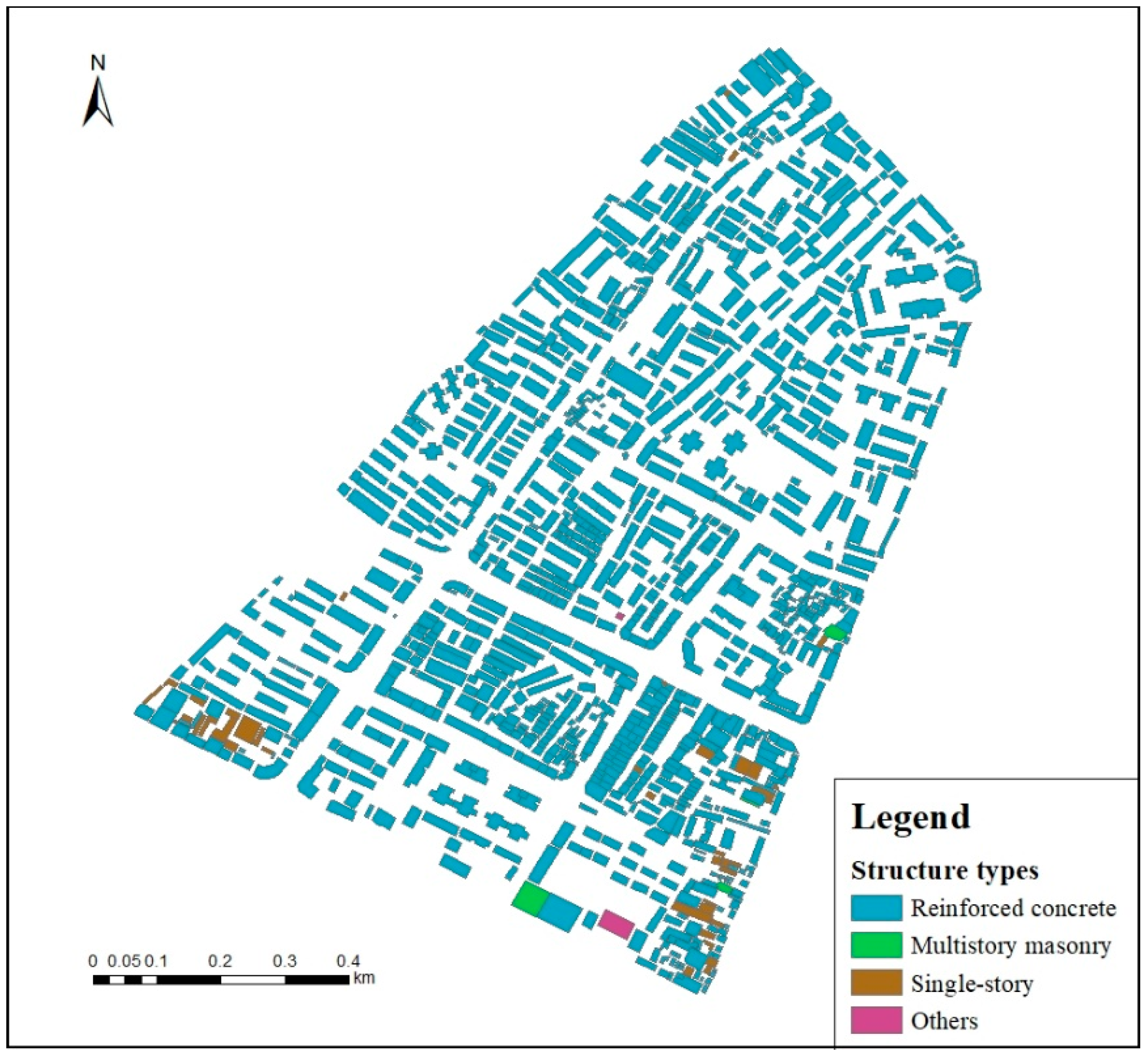
There are 1241 single buildings in the study area, with a total area of 1.51 million m2. Among them, 1189 single buildings are the reinforced concrete structure, accounting for about 95.81% of the total number and 99.03% (1.49 million m2) of the total building area; the other three structures (multistory masonry, single–story, and others) accounted for 4.19% (52) and 0.97% (0.02 million m2) of the total (Figure 2).
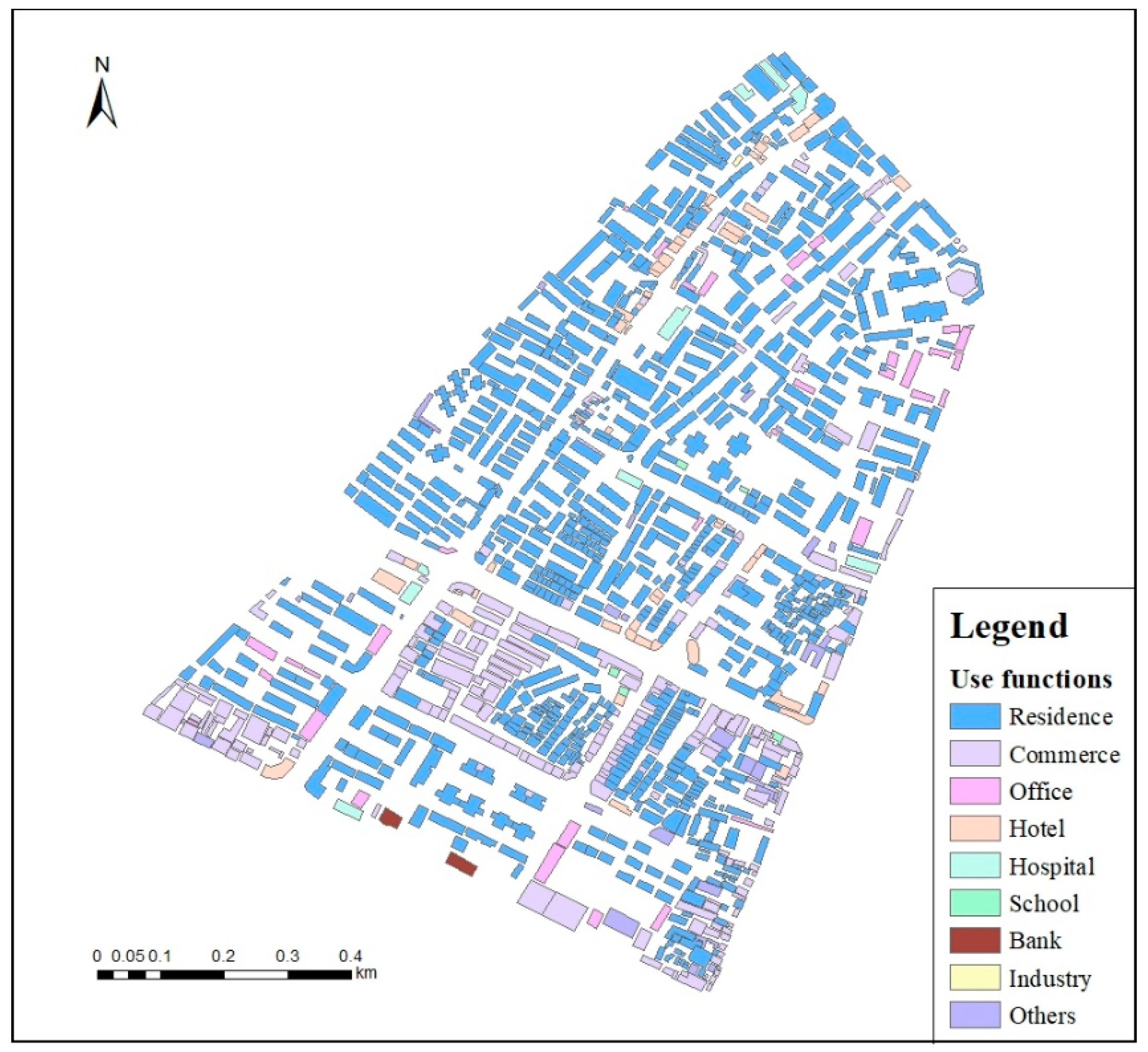
Considering the distribution of different functional buildings, over 70% (876 of 1241) of the total buildings are residential buildings in the study area. Commercial, hotel, and office buildings accounted for 18.53% (230), 4.35% (54), and 2.74% (34) of the total, respectively. The other five functional buildings, including medical, school, financial, industry, and others, accounted for 3.79% (47) of the total (Figure 3).

4.2. Population Distribution at Different Times of the Day

4.2.1. Population Accommodation Density of Various Buildings

The daily population density that buildings with different functions could accommodate is different. Due to human activities during the day, the accommodation population densities in schools, banks, hospitals, and other nonresidential buildings are significantly higher than those in residential buildings. According to 2018 statistics [50], the average residential population density in the study area is 0.009 people per m2. Based on the ratios of average GRMPPFs for different nonresidential buildings to that of residential buildings (Table 3), using Equations (3) and (4), the average accommodation population densities of commercial, office, hotel, hospital, school, financial, industry, and other functional buildings could be calculated, which are 0.011, 0.013, 0.022, 0.047, 0.067, 0.083, 0.012, and 0.005 people per m2, respectively.

4.2.2. Occupancy Rate Changes in Different Functional Buildings in a Day

Based on the field investigation and existing work on indoor rates, we can determine the average indoor rates for different functional buildings during the different time stages of a single day (Figure 4). Figure 4a,b shows the changes in indoor population rates on workdays and non–workdays, respectively. We found that for the same functional buildings, the indoor rate changes significantly over time. For the different functional buildings, their indoor rates also show significant differences at the same time. Especially on workdays, the indoor rates of nonresidential buildings are highest during the 8:00–12:00 and 14:00–17:00 time stages, and the lowest indoor rate occurs during 22:00–next 7:00. In contrast, for residential buildings, the highest indoor rate occurs during 22:00–next 7:00 and the lowest rate is during the 8:00–12:00 and 14:00–17:00 time stages (Figure 4a). On non–workdays, the trend is similar to that on weekdays, except for school, office, and other buildings, the occupancy rates of which are all zero throughout the whole day (Figure 4b).

4.2.3. Spatiotemporal Changes of Population Exposure in Different Functional Buildings

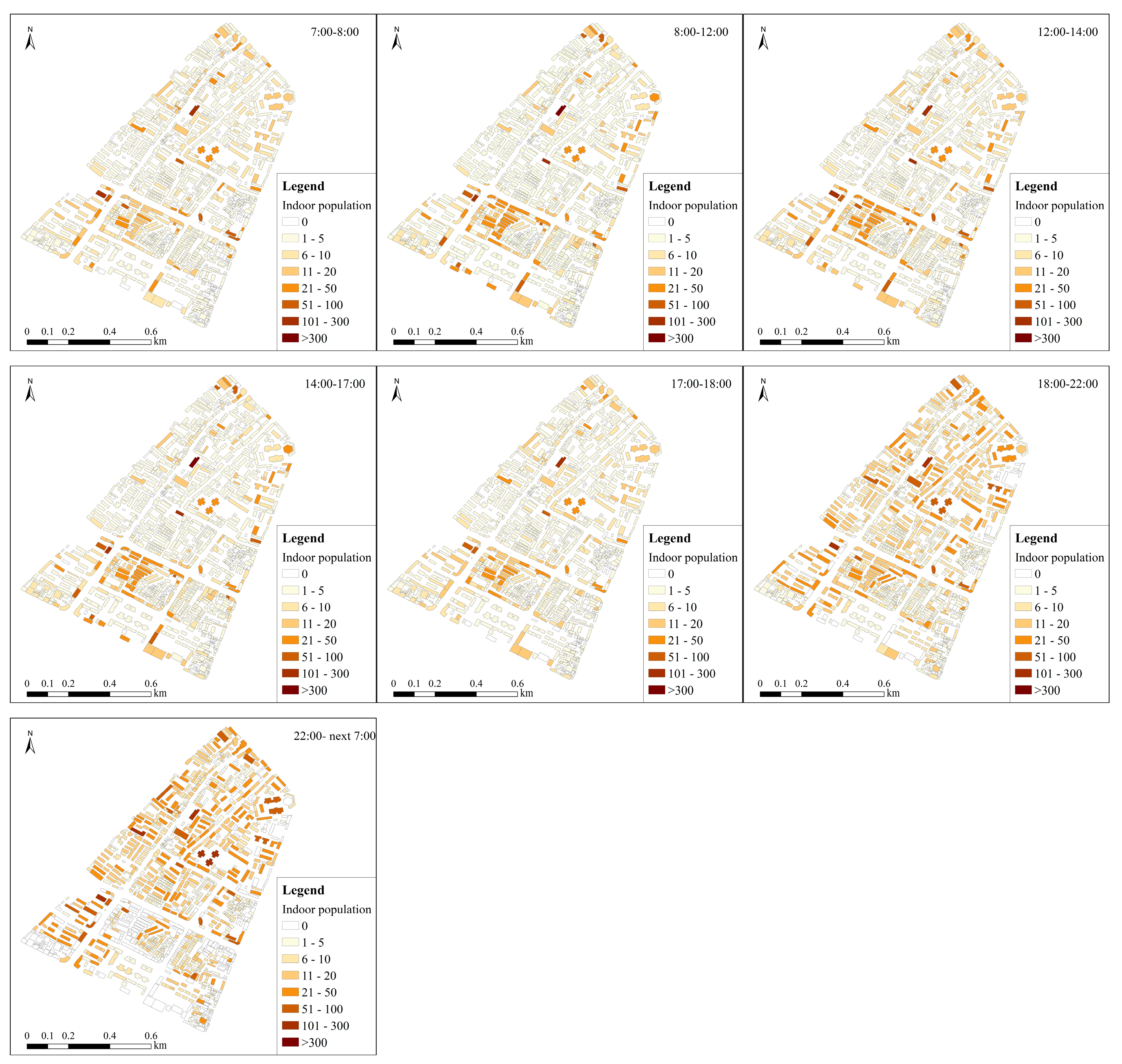
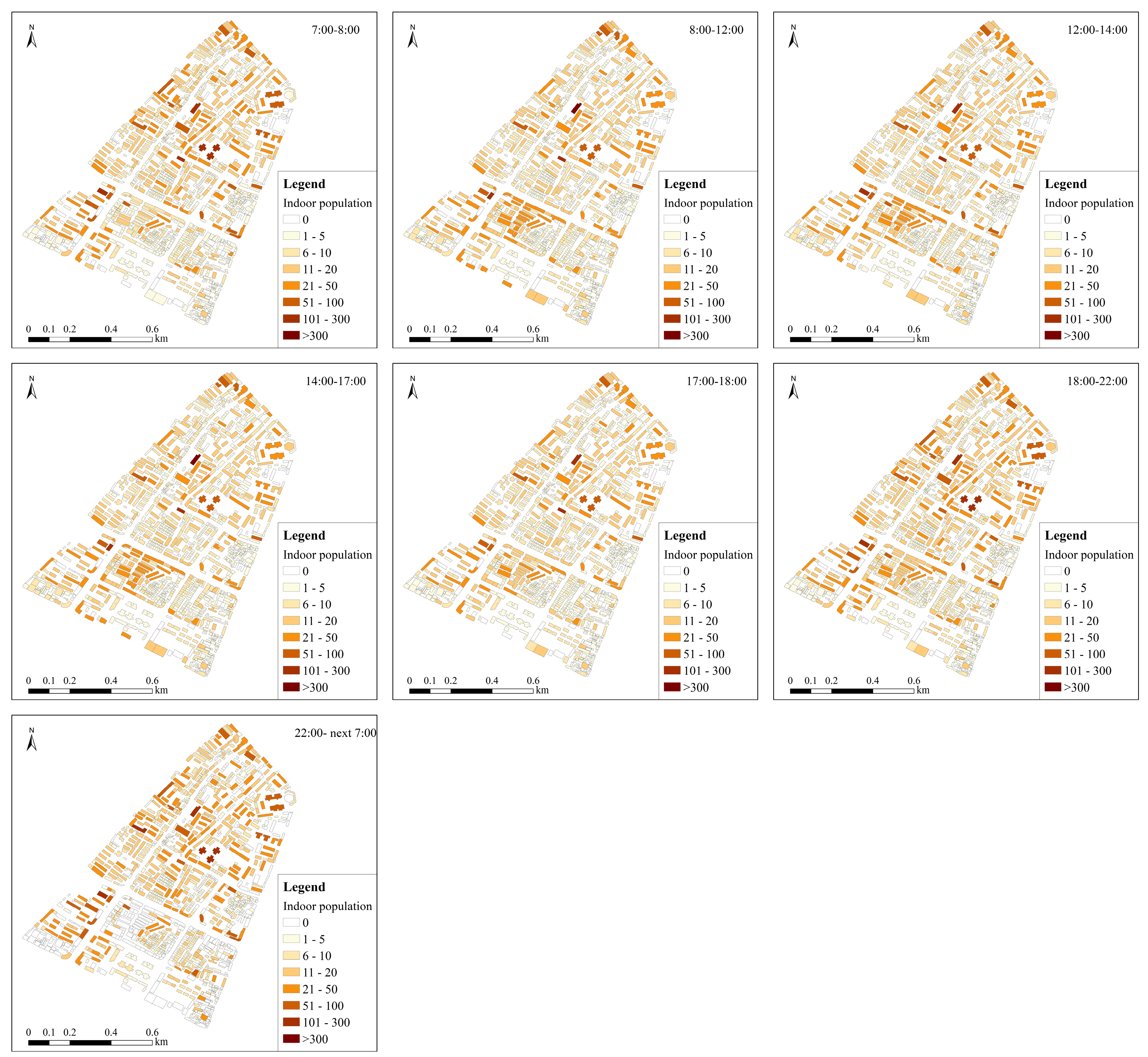
Figure 5 and Figure 6 show the changes in indoor population exposure in single buildings with different functions on weekdays and non–weekdays, respectively. During working days, the indoor population distribution in single buildings shows significant changes in different time periods (Figure 5). Overall, from 7:00 to 18:00, the indoor population is mainly distributed in commercial buildings, offices, and other nonresidential buildings, while from 18:00 to 7:00, the indoor population is mainly concentrated in residential buildings. The number of people in the room during working hours and rest hours during the day in the same building changes significantly. However, on non–weekdays, although the distribution of the indoor population in single buildings also changes in different time periods, the difference is not obvious compared with that on weekdays (Figure 6). The population is mainly concentrated in residential, commercial, medical, and hotel buildings.
To better distinguish the differences in indoor populations in different functional buildings at different times, Figure 7a,b shows the changes in total indoor population exposure on workdays and non–workdays, respectively. After 6 p.m. on weekdays, the total indoor population showed a significant increasing trend in the study area. Among them, the highest population in the room existed from 22:00 to 7:00, which accounted for approximately 84.36% of the total population. From 17:00 to 18:00 and from 7:00 to 8:00 are the two periods with the lowest number of people in the room, accounting for approximately 33.48% and 36.41% of the total population, respectively. During 8:00–17:00 on weekdays, approximately 43–45% of the total population was in the room (Figure 7a).
On non–weekdays, the changing trend of the population in the room over time is different from that on working days (Figure 7b). First, in each time period, the indoor population on nonworking days was significantly higher than that on working days. On weekdays, an average of approximately 50% (50.41%) of the total population is located in a room during the day. However, an average of 73.96% of the total population is located in a room on non–weekdays. Second, compared with that on weekdays (36.41%), the number of indoor people from 7 a.m. to 8 a.m. has significantly increased, which has doubled (77.95%). Additionally, although the highest and lowest indoor populations still occurred from 22:00 to 7:00 and from 17:00 to 18:00, the minimum indoor population increased significantly (63.31% of the total population).
Due to the differences in people’s activities, the indoor population is not evenly distributed in buildings with different functions at the same time. For example, from 8:00 to 12:00 on weekdays, approximately 29.12% and 26.00% of the total indoor population is distributed in commercial and residential buildings, respectively. Approximately 18.26%, 11.19%, and 10.24% of the indoor population are distributed in hospitals, hotels, and office buildings, respectively. The indoor population in banks, industries, and other buildings accounts for only 1.97%. From 22:00 to 7:00, approximately 85.52% of the total indoor population is concentrated in residential buildings, and 10.95% and 3.53% of the indoor population is distributed in hotels and medical buildings, respectively (Figure 7a).
On non–weekdays (Figure 7b), the population in the room is mainly distributed in residential, commercial, hotel, and hospital buildings. For example, from 8:00 to 12:00, approximately 63.52% of the total indoor population was distributed in residential buildings. Approximately 16.58%, 12.48%, and 6.79% of the indoor population are distributed in commercial buildings, hospitals, and hotel buildings, respectively. From 22:00 to 7:00, the indoor population was mainly concentrated in residential buildings (85.52%), hotels (10.59%), and medical buildings (3.53%).

5. Discussion

5.1. Spatiotemporal Distribution Law of Indoor Population

Behavioral geography holds that an individual’s daily activities are always composed of habitual behaviors such as work, rest, and shopping. Residents choose travel activities according to their own life and work needs, which has regularity over time [61]. This theoretical basis aids us in studying the temporal and spatial distribution of indoor populations. Due to the difference in peoples’ travel purposes, there are great differences in population distribution at different times of the day. The temporal and spatial distribution of the indoor population could be affected by numerous factors [24,62], such as population density, population structure, holidays, weather, etc. For buildings with different use functions, there are not only significant differences in the daily population density but also significant changes in the indoor population rate during the day. This difference results in a change in population distribution in different functional buildings. Our results showed that people are mainly concentrated in residential buildings at night, accounting for over 80% of the total population. The extent of population exposure in residential buildings is the highest at night. During the daytime on working days, people will gather from residential to nonresidential buildings such as offices, commerce, and schools due to the needs of work, shopping, or other activities. Thus, the indoor population is also concentrated from residential buildings to nonresidential buildings during the daytime. For example, nearly 70% of the total population is located in commercial, office, hospital, and other nonresidential buildings from 8:00 to 12:00 on weekdays. These conclusions on the temporal and spatial changes in population distribution in this study are consistent with those of other similar studies [5,39,49].
In addition, our study also found that the distribution of the indoor population on non–weekdays was significantly different from that on weekdays. Due to holiday breaks, the average proportion of the indoor population on nonworking days was significantly higher than that on working days. The exposure distribution of the indoor population at different times of the day is still different, but the change in this difference over time is generally small compared with that on working days. During a non–weekday, the indoor population would be mainly distributed in residential buildings, followed by commercial and hotel buildings. During non–working hours, there is rarely a population distribution in schools, offices, and other buildings. In other words, various travel activities of urban residents are basically carried out around urban buildings, such as shopping, work, school, etc. The different use functions of buildings determine their attraction to specific people in a specific period of the day, thus affecting the distribution of indoor populations in different periods of time. The evaluation of fine–scale indoor population distribution, considering building use function, plays an important role in understanding the spatiotemporal variation laws of regional population exposure. This is of great practical significance for assessing the risk of regional population losses and formulating pre–disaster preparation and post–disaster response measures.

5.2. Implications and Limitations

Population exposure is an important element of effective risk analysis and disaster loss assessment [11,63]. High–resolution population spatiotemporal distribution data are of great significance for accurately assessing the risk of trapped people and casualties. Population distributions vary widely over time, especially in metropolitan areas due to human activities. This variation results in different population exposure risks in different buildings during the day. The use function of buildings is one of the key factors affecting the temporal and spatial distributions of urban populations. Unfortunately, the use functions of buildings have rarely been considered in previous research on population spatialization due to the limitation of data availability. In this study, we constructed a model to evaluate the spatiotemporal distribution of indoor populations at the scale of single buildings. This method considers the differences in accommodation population densities among various functional buildings and distinguishes their changes in indoor rates during 24 h of a day. Our study shows that even in the same building, there are great differences in the extent of population exposure in a day. Due to people’s activities, at the same time, the population exposure in buildings with different functions is also significantly different. This can provide an important practical reference for local disaster preparedness and post–disaster emergency response.
Anti–seismic performances of buildings mainly depend on their structural types. Generally, the anti–seismic performances of reinforced concrete, multistory masonry, single–story, and other structures are weakened in turn. Therefore, using the spatiotemporal distribution results of indoor populations, combined with the structural type and vulnerability matrix of buildings, the risk of population losses at the single–building scale under different earthquake scenarios can be mapped. In this study area, because most buildings are reinforced concrete structures (95.81% of the total buildings), the exposure degree of the indoor population could basically reflect the risk extent of casualties under the same earthquake impact, which could provide an important reference for regional disaster preparedness and post–disaster emergency rescue.
Although the method constructed in this study could map the high spatiotemporal resolution changes in the indoor population distribution, it could still be further improved in the future. For example, the impact of population structure on indoor population distribution is not considered in this study. In fact, the content and time of daily travel activities of different groups are different and have their own regularity [64,65,66]. In addition, the functional classification system of buildings can be further refined to improve the determination of population densities for different functional buildings. Finally, with the rapid development of mobile information and big data technology, location–based service data and POI data could greatly enrich the studies on the dynamic spatial and temporal changes in human activity behaviors [67,68,69]. It could be considered to introduce location–based service techniques to study the law of population flow to further assess the real–time distribution of indoor population exposure in the future.

6. Conclusions

By distinguishing the differences in population densities for various functional buildings and the changes in indoor rates during the day, this study constructed a model of indoor population spatiotemporal distribution assessment at the scale of single buildings. The application of the model in Dongcheng Subdistrict, Xichang City, China, showed that this method could identify the changes in indoor population in different single buildings in a day and map the high–resolution spatiotemporal distribution of regional indoor population exposure.
Due to people’s activities, the distribution of indoor populations in different functional buildings changes significantly during the day. At the same time in a day, the indoor rate and exposure level of the population has significant difference in buildings with different functions. At night, the exposure level of the indoor population in residential buildings is the highest. On working days, the exposure of the indoor population decreased significantly from night to day. On the contrary, the exposure of the indoor population in buildings such as commercial buildings in the daytime increased significantly. On the weekend days, the indoor population exposure in residential buildings fluctuated but remained at a high level throughout the day. The change in the indoor population over time was more obvious on weekdays, and population spatial distribution also changed significantly compared with the changes on weekend days.
Although there are still some limitations, this study offers a rapid assessment tool for the spatiotemporal distribution of indoor populations based on single buildings. The assessment results could provide an important reference for regional disaster preparedness and post–disaster emergency rescue. The spatiotemporal distribution of the indoor population at the building scale could also play a practical role in risk analysis and emergency management. This method could be applied in other areas if the corresponding data are replaced. The accuracy of the model constructed in this study can be further improved by considering the effects of population structure and further refining the functional classification system of buildings in the future.

Author Contributions

Conceptualization, B.W.; methodology, B.W.; formal analysis, B.W. and W.Q.; investigation, B.H., B.W. and W.Q.; resources, B.W. and B.H.; data curation, B.W.; writing—original draft preparation, B.W.; writing—review and editing, B.W. and W.Q.; supervision, B.W.; project administration, B.W. and B.H.; funding acquisition, B.W. All authors have read and agreed to the published version of the manuscript.

Funding

This work was funded jointly by the Key Special Fund for the Earthquake Disaster Scenario Construction of Large and Medium–Sized Cities (2016QJGJ13) and the National Key R&D Program of China (2018YFC1504403).

Institutional Review Board Statement

Not applicable.

Informed Consent Statement

Not applicable.

Data Availability Statement

The data that support the findings of this study are available from the corresponding authors upon reasonable request.

Conflicts of Interest

The authors declare no conflict of interest.

References

  1. UNDP. Reducing Disaster Risk: A Challenge for Development; UNDP Bureau for Crisis Prevention and Recovery: New York, NY, USA, 2004. [Google Scholar]
  2. Coburn, A.; Spence, R. Earthquake Protection, 2nd ed.; John Wiley & Sons: Chichester, UK, 2002. [Google Scholar]
  3. Işık, E.; Sağır, Ç.; Tozlu, Z.; Ustaoğlu, Ü.S. Determination of Urban Earthquake Risk for Kırşehir, Turkey. Earth Sci. Res. J. 2019, 23, 237–247. [Google Scholar] [CrossRef]
  4. UNISDR. Making Development Sustainable: The Future of Disaster Risk Management. Global Assessment Report on Disaster Risk Reduction; United Nations Office for Disaster Risk Reduction (UNISDR): Geneva, Switzerland, 2015. [Google Scholar]
  5. Freire, S. Modeling of Spatiotemporal Distribution of Urban Population at High Resolution—Value for Risk Assessment and Emergency Management. In Intelligent Systems for Crisis Management; Springer: Berlin/Heidelberg, Germany, 2010. [Google Scholar]
  6. Liang, Y.T.; Wen, J.H.; Du, S.Q.; Xu, H.; Yan, J.P. Spatial–temporal distribution modeling of population and its applications in disaster and risk management. J. Catastrophology 2015, 30, 220–228. [Google Scholar]
  7. FEMA (Federal Emergency Management Agency). Multihazard loss estimation methodology—Earthquake model. In HAZUS–MH MR4: Technical Manual; Department of Homeland Security: Washington, DC, USA, 2003. [Google Scholar]
  8. Sutton, P.; Elvidge, C.; Obremski, T. Building and evaluating models to estimate ambient population density. Photogramm. Eng. Remote Sens. 2003, 69, 545–553. [Google Scholar] [CrossRef]
  9. Chen, K.; Mc Aneney, J.; Blong, R.; Leigh, R.; Hunter, L. Magill CDefining area at risk and its effect in catastrophe loss estimation: A dasymetric mapping approach. Appl. Geogr. 2004, 24, 97–117. [Google Scholar] [CrossRef]
  10. NRC (National Research Council). Tools and Methods for Estimating Populations at Risk from Natural Disasters and Complex Humanitarian Crises; Report by the National Academy of Sciences; National Academy Press: Washington, DC, USA, 2007.
  11. Corner, R.J.; Ongee, E.T.; Dewan, A.M. Spatiotemporal Patterns of Population Distribution; Dewan, A., Corner, R., Eds.; Dhaka Megacity; Springer Geography; Springer: Dordrecht, The Netherlands, 2014. [Google Scholar]
  12. Wu, S.S.; Qiu, X.; Wang, L. Population estimation methods in GIS and remote sensing: A review. GIScience Remote Sens. 2005, 42, 80–96. [Google Scholar] [CrossRef]
  13. Azar, D.; Engstrom, R.; Graesser, J.; Comenetz, J. Generation of fine–scale population layers using multi–resolution satellite imagery and geospatial data. Remote Sens. Environ. 2013, 130, 219–232. [Google Scholar] [CrossRef]
  14. Pan, S.; Du, S.Q.; Xu, H.; Wu, Y.J.; Wang, L.M.; Zong, W.; Wen, J.H. Spatio–Temporal Analysis on Low Elevation Coastal Zone and Its Population in the Yangtze River Delta Region. Areal Res. Dev. 2016, 35, 161–165. [Google Scholar]
  15. Xu, J.H.; An, J.W.; Nie, G.Z. A quick earthquake disaster loss assessment method supported by dasymetric data for emergency response in China. Nat. Hazards Earth Syst. Sci. 2016, 16, 885–899. [Google Scholar] [CrossRef]
  16. Ding, W.X.; Li, X.L.; Li, Z.Q.; Dou, A.X.; Zhang, Y.M.; Temu, Q.L. Population and housing grid spatialization in Yunnan Province based on grid sampling and application of rapid earthquake loss assessment: The Jinggu Ms6.6 earthquake. Geod. Geodyn. Geod. Geodyn. 2014, 5, 25–33. [Google Scholar]
  17. Feng, T.T. Urban Small Area Population Estimation Based on High–Resolution Remote Sensing Data; Wuhan University: Wuhan, China, 2010. [Google Scholar]
  18. Bai, Z.Q.; Wang, J.L.; Yang, F. Research progress in spatialization of population data. Prog. Geogr. 2013, 32, 1692–1702. [Google Scholar]
  19. Freire, S.; Aubrecht, C. Integrating population dynamics into mapping human exposure to seismic hazard. Nat. Hazards Earth Syst. Sci. 2012, 12, 3533–3543. [Google Scholar] [CrossRef]
  20. Kang, C.G.; Liu, Y.; Ma, X.J.; Wu, L. Towards estimating urban population distributions from mobile call data. J. Urban Technol. 2012, 19, 3–21. [Google Scholar] [CrossRef]
  21. Ara, S. Impact of temporal population distribution on earthquake loss estimation: A case study on Sylhet, Bangladesh. Int. J. Disaster Risk Sci. 2014, 5, 296–312. [Google Scholar] [CrossRef]
  22. De Lotto, R.; Pietra, C.; Venco, E.M. Risk Analysis: A Focus on Urban Exposure Estimation. In Computational Science and Its Applications—ICCSA 2019; Mirsra, S., Gervasi, O., Murgante, B., Stankova, E.N., Korkhov, V., Torre, C.M., Rocha, A.M.A.C., Taniar, D., Apduhan, B.O., Tarantino, E., Eds.; Springer: Cham, Switzerland, 2019. [Google Scholar]
  23. Rivera, F.; Rossetto, T.; Twigg, J. An interdisciplinary study of the seismic exposure dynamics of Santiago de Chile. Int. J. Disaster Risk Reduct. 2020, 48, 101581. [Google Scholar] [CrossRef]
  24. Wei, B.Y.; Nie, G.Z.; Su, G.W.; Sun, L.; Bai, X.F.; Qi, W.H. Risk assessment of people trapped in earthquake based on km grid: A case study of the 2014 Ludian earthquake, China. Geomat. Nat. Hazards Risk 2017, 8, 1289–1305. [Google Scholar] [CrossRef]
  25. Yang, X.H.; Jiang, D.; Wang, N.B.; Liu, H. Method of pixelizing population data. Acta Geogr. Sin. 2002, 57, 71–75. [Google Scholar]
  26. Yang, X.H.; Liu, Y.S.; Jiang, D.; Luo, C.; Huang, Y. An Enhanced Method for Spatial Distributing Census Data: Re–classifying of Rural Residential. Prog. Geogr. 2006, 25, 62–69. [Google Scholar]
  27. Zhuo, L.; Chen, J.; Shi, P.J.; Gu, Z.H.; Fan, Y.D.; Toshiaki, I. Modeling population density of China in 1998 based on DMSP/OLS nighttime light image. Acta Geogr. Sin. 2005, 60, 266–276. [Google Scholar]
  28. Yang, X.Y.; Jiang, G.M.; Luo, X.Z.; Zheng, Z. Preliminary mapping of high– resolution rural population distribution based on imagery from Google Earth: A case study in the Lake Tai basin, eastern China. Appl. Geogr. 2012, 32, 221–227. [Google Scholar] [CrossRef]
  29. Fisher, P.F.; Langford, M. Modeling sensitivity to accuracy in classified imagery: A study of areal interpolation by dasymetric mapping. Prof. Geogr. 1996, 48, 299–309. [Google Scholar] [CrossRef]
  30. Su, M.D.; Lin, M.C.; Hsieh, H.I.; Tsai, B.W.; Lin, C.H. Multi–layer multi–class dasymetric mapping to estimate population distribution. Sci. Total Environ. 2010, 408, 4807–4816. [Google Scholar] [CrossRef] [PubMed]
  31. Jia, P.; Qiu, Y.; Gaughan, A.E. A fine–scale spatial population distribution on the high–resolution gridded population surface and application in Alachua County. Fla. Appl. Geogr. 2014, 50, 99–107. [Google Scholar] [CrossRef]
  32. Hu, L.; He, Z.; Liu, J. Adaptive multi–scale population spatialization model constrained by multiple factors: A case study of Russia. Cartogr. J. 2017, 54, 265–282. [Google Scholar] [CrossRef]
  33. Gallego, F.J. A population density grid of the European Union. Popul. Environ. 2010, 31, 460–473. [Google Scholar] [CrossRef]
  34. Dong, N.; Yang, X.H.; Cai, H.Y. Research progress and perspective on the spatialization of population data. J. Geo–Inf. Sci. 2016, 18, 1295–1304. [Google Scholar]
  35. Tobler, W.; Deichmann, U.; Gottsegen, J. World population in a grid of spherical quadrilaterals. Int. J. Popul. Geogr. 1997, 3, 203–225. [Google Scholar] [CrossRef]
  36. Dobson, J.E.; Bright, E.A.; Coleman, P.R.; Durfee, R.C.; Worley, B.A. A global population database for estimating population at risk. Photogramm. Eng. Remote Sens. 2000, 66, 849–857. [Google Scholar]
  37. Gaughan, A.E.; Stevens, F.R.; Linard, C.; Jia, P.; Tatem, A.J. High resolution population distribution maps for southeast Asia in 2010 and 2015. PLoS ONE 2013, 8, e55882. [Google Scholar] [CrossRef]
  38. Linard, C.; Altare, C.; Guha, S.D. Demographic Data from Conflict–Affected Regions of the Congo Basin: Potential from the AfriPop and CEDAT Dtabases. DI–Fusion. 2013. Available online: http://hdl.handle.net/2078.1/142519 (accessed on 29 March 2022).
  39. Yuan, H.; Gao, X.; Qi, W. Modeling the fine–scale spatiotemporal pattern of earthquake casualties in cities: Application to Haidian District, Beijing. Int. J. Disaster Risk Reduct. 2019, 34, 412–422. [Google Scholar] [CrossRef]
  40. Alçada–Almeida, L.; Tralhão, L.; Santos, L.; Coutinho–Rodrigues, J. A multiobjective approach to locate emergency shelters and identify evacuation routes in urban areas. Geogr. Anal. 2009, 41, 9–29. [Google Scholar] [CrossRef]
  41. Martin, D.; Cockings, S.; Leung, S. Progress report: 24–hour gridded population models. In Proceedings of the European Forum for Geostatistics Conference, Tallinn, Estonia, 5–7 October 2010. [Google Scholar]
  42. Aubrecht, C.; Freire, S.; Neuhold, C.; Curtis, A.; Steinnocher, K. Introducing a temporal component in spatial vulnerability analysis. Disaster Adv. 2012, 5, 48–53. [Google Scholar]
  43. Wei, B.Y.; Nie, G.Z.; Su, G.W.; Guo, X.X. Risk assessment of people trapped in earthquake disasters based on a single building: A case study in Xichang city, Sichuan Province, China. Geomat. Nat. Hazards Risk 2022, 13, 167–192. [Google Scholar] [CrossRef]
  44. Hancılar, U.; Tuzun, C.; Yenidogan, C.; Erdik, M. ELER software—A new tool for urban earthquake loss assessment. Nat. Hazards Earth Syst. Sci. 2010, 10, 2677–2696. [Google Scholar] [CrossRef]
  45. Park, J.H.; Shin, M.; Cho, G.H. A dynamic estimation of casualties from an earthquake based on a time–use survey: Applying HAZUS–MH software to Ulsan, Korea. Nat. Hazards 2016, 81, 289–306. [Google Scholar] [CrossRef]
  46. Yang, H. The Urban Population Dynamics Distribution Simulation at Day’s Based on GIS—A Case Study in Beibei District, Chongqing; Southwest University: Chongqing, China, 2011. [Google Scholar]
  47. Zhang, L. Dynamics Simulation of High Temporal Resolution Urban Population: A Case Study in Beibei District, Chongqing; Southwest University: Chongqing, China, 2012. [Google Scholar]
  48. Tian, L.L. Analysis on Influence Factor of Earthquake Disaster Casualties and Estimation Formula; Capital University of Economics and Business: Beijing, China, 2012. [Google Scholar]
  49. Li, J.; Li, J.; Yuan, Y.; Li, G. Spatiotemporal distribution characteristics and mechanism analysis of urban population density: A case of Xi’an, Shaanxi, China. Cities 2019, 86, 62–70. [Google Scholar] [CrossRef]
  50. XSB (Xichang Statistics Bureau). Xichang Statistics Yearbook (2018); Xichang Statistics Bureau: Xichang, China, 2019. [Google Scholar]
  51. MHURD (Ministry of Housing and Urban Rural Development of the People's Republic of China). Code for Classification of Urban Land Use and Planning Standards of Development Land GB50137–2011; China Architecture & Building Press: Beijing, China, 2011.
  52. RGTG (Research Group of Trip Generation). Trip Generation; China Architecture& Building Press: Beijing, China, 2009. [Google Scholar]
  53. Zhang, Z.M.; Zhou, Y.; Li, Q.; Lin, Y.X. An estimation method of dynamic population within an urban local area. J. Geo–Inf. Sci. 2010, 12, 503–509. [Google Scholar] [CrossRef]
  54. Cheng, J.Y. Probability of the original time of earthquake affecting the casualty. J. Catastrophology 1993, 8, 14–16. [Google Scholar]
  55. Xiao, D.S.; Huang, D.F.; Chen, W.F. Study on apriority of in–building rate based on buried rate. J. Nat. Disasters 2009, 18, 92–97. [Google Scholar]
  56. Su, G.W.; Qi, W.H.; Zhang, S.L.; Sim, T.; Liu, X.S.; Sun, R.; Sun, L.; Jin, Y.F. An integrated method combining remote sensing data and local knowledge for the large–scale estimation of seismic loss risks to buildings in the context of rapid socioeconomic growth: A case study in Tangshan, China. Remote Sens. 2015, 7, 2543–2601. [Google Scholar] [CrossRef]
  57. BTDRC (Beijing Transportation Development Research Center). Simplified Version of Trip Generation in Beijing; Beijing Communications Commission: Beijing, China, 2007. [Google Scholar]
  58. Chen, F. Research on Evaluation Method of Seismic Casualties and Program Implementation; Xi’an University of Architecture and Technology: Xi’an, China, 2016. [Google Scholar]
  59. Zheng, L.T.; Zhao, L.H. Investigation and analysis on staff schedule in large–scale shopping mall in hot summer and warm winter zone. Heating Ventilating & Air Conditioning. 2020, 50, 87–110. [Google Scholar]
  60. Li, S.J.; Wang, L.M.; Dong, N. Simulation of urban small–area population spatio–temporal distribution based on building extraction: Taking Beijing Donghuamen Subdistrict as an example. J. Geo–Inf. Sci. 2013, 15, 19–28. [Google Scholar]
  61. Chai, Y.W.; Yan, Y.N.; Okamoto, K. Development of behavioral geographic research in western countries and its recent progress. Hum. Geogr. 2008, 23, 1–7. [Google Scholar]
  62. Choi, Y.; Yoon, H.; Kim, D. Where do people spend their leisure time on dusty days? Application of spatiotemporal behavioral responses to particulate matter pollution. Ann. Reg. Sci. 2019, 63, 317–339. [Google Scholar] [CrossRef]
  63. Yang, X.; Yao, C.; Chen, Q.; Ye, T.; Jin, C. Improved estimates of population exposure in Low–Elevation Coastal Zones of China. Int. J. Environ. Res. Public Health 2019, 16, 4012. [Google Scholar] [CrossRef]
  64. Li, Z.R. Study on Time Geography of Traffic Travel Behavior of Urban Residents in China; Peking University: Beijing, China, 2000. [Google Scholar]
  65. Chen, T.S. Study on Characteristics and Analysis Methods of Commuters' Travel Behavior; Beijing Jiaotong University: Beijing, China, 2007. [Google Scholar]
  66. Chai, Y.W.; Shen, J. Activity–based Approach to Human Spatial Behavior Research. Sci. Geogr. Sin. 2008, 28, 594–600. [Google Scholar]
  67. Shaw, S.L.; Tsou, M.H.; Ye, X. Editorial: Human dynamics in the mobile and big data era. Int. J. Geogr. Inf. Sci. 2016, 30, 1687–1693. [Google Scholar] [CrossRef]
  68. Wu, C.; Ye, X.; Ren, F.; Du, Q. Check–in behaviour and spatio–temporal vibrancy: An exploratory analysis in Shenzhen, China. Cities 2018, 77, 104–116. [Google Scholar] [CrossRef]
  69. García–Palomares, J.C.; Salas–Olmedo, M.H.; Moya–Gómez, B.; Condeço–Melhorado, A.; Gutiérrez, J. City dynamics through Twitter: Relationships between land use and spatiotemporal demographics. Cities 2018, 72, 310–319. [Google Scholar] [CrossRef]
Figure 1. The studied area.
Sustainability 15 07423 g001
Figure 2. Building distribution with different structural types.
Sustainability 15 07423 g002
Figure 3. Building distribution with various use functions.
Sustainability 15 07423 g003
Figure 4. Indoor rate changes in population in different functional buildings. ((a) Workdays; (b) Non–workdays).
Sustainability 15 07423 g004
Figure 5. Single building–scale indoor population changes over time on weekdays.
Sustainability 15 07423 g005
Figure 6. Single building–scale indoor population changes over time on non–weekdays.
Sustainability 15 07423 g006
Figure 7. Changes in total indoor population exposure over time in the study area. ((a) Workdays; (b) Non–workdays).
Sustainability 15 07423 g007
Table 1. The classification system of urban building used in this study.
CodesRBAHMSFIO
Classificationresidentialcommercialofficehotelmedicalschoolfinancialindustrialothers
Table 2. Basic information of buildings extracted.
Use FunctionsNumberArea/m2Buildings StructuresNumberArea/m2
Residence8761,144,043.49Reinforced concrete11891,491,784.31
Commerce230202,204.15Multistory masonry42569.76
Office3456,597.52Single–story439940.68
Hotel5459,443.38Others22169.16
Hospital928,455.19
School52999.97
Bank21426.32
Industry1125.43
Others3011,168.45
Table 3. The ratios of average GRMPPFs of different nonresidential buildings to that of residential buildings.
Function TypesResidenceCommerceOfficeHotelHospitalSchoolBankIndustryOthers
Ratios1.001.181.42.465.267.469.271.380.58
Disclaimer/Publisher’s Note: The statements, opinions and data contained in all publications are solely those of the individual author(s) and contributor(s) and not of MDPI and/or the editor(s). MDPI and/or the editor(s) disclaim responsibility for any injury to people or property resulting from any ideas, methods, instructions or products referred to in the content.