Article

The Accuracy of Land Use and Cover Mapping across Time in Environmental Disaster Zones: The Case of the B1 Tailings Dam Rupture in Brumadinho, Brazil

by
Carlos Roberto Mangussi Filho
1,
Renato Farias do Valle Junior
1,
Maytê Maria Abreu Pires de Melo Silva
1,
Rafaella Gouveia Mendes
1,
Glauco de Souza Rolim
2,
Teresa Cristina Tarlé Pissarra
2,
Marília Carvalho de Melo
3,
Carlos Alberto Valera
4,
Fernando António Leal Pacheco
2,5,* and
Luís Filipe Sanches Fernandes
6
1
Geoprocessing Laboratory, Uberaba Campus, Federal Institute of Triângulo Mineiro (IFTM), Uberaba 38064-790, MG, Brazil
2
Faculdade de Ciências Agrárias e Veterinárias, Universidade Estadual Paulista (UNESP), Via de Acesso Prof. Paulo Donato Castellane, s/n, Jaboticabal 14884-900, SP, Brazil
3
Secretaria de Estado de Meio Ambiente e Desenvolvimento Sustentável, Cidade Administrativa do Estado de Minas Gerais, Rodovia João Paulo II, 4143, Bairro Serra Verde, Belo Horizonte 31630-900, MG, Brazil
4
Coordenadoria Regional das Promotorias de Justiça do Meio Ambiente das Bacias dos Rios Paranaíba e Baixo Rio Grande, Rua Coronel Antônio Rios, 951, Uberaba 38061-150, MG, Brazil
5
Center of Chemistry of Vila Real (CQVR), University of Trás-os-Montes e Alto Douro, Ap. 1013, 5001-801 Vila Real, Portugal
6
Center for Research and Agro-Environmental and Biological Technologies (CITAB), University of Trás-os-Montes e Alto Douro, Ap. 1013, 5001-801 Vila Real, Portugal
*
Author to whom correspondence should be addressed.
Sustainability 2023, 15(8), 6949; https://doi.org/10.3390/su15086949
Submission received: 13 December 2022 / Revised: 24 March 2023 / Accepted: 17 April 2023 / Published: 20 April 2023

Abstract

:
The rupture of a tailings dam causes several social, economic, and environmental impacts because people can die, the devastation caused by the debris and mud waves is expressive and the released substances may be toxic to the ecosystem and humans. There were two major dam failures in the Minas Gerais state, Brazil, in the last decade. The first was in 2015 in the city of Mariana and the second was in 2019 in the municipality of Brumadinho. The extent of land use and cover changes derived from those collapses were an expression of their impacts. Thus, knowing the changes to land use and cover after these disasters is essential to help repair or mitigate environmental degradation. This study aimed to diagnose the changes to land cover that occurred after the failure of dam B1 in Brumadinho that affected the Ferro-Carvão stream watershed. In addition to the environmental objective, there was the intention of investigating the impact of image preparation, as well as the spatial and spectral resolution on the classification’s accuracy. To accomplish the goals, visible and near-infrared bands from Landsat (30 m), Sentinel-2 (10 m), and PlanetScope Dove (4.77 m) images collected between 2018 and 2021 were processed on the Google Earth Engine platform. The Pixel Reduction to Median tool was used to prepare the record of images, and then the random forest algorithm was used to detect the changes in land cover caused by the tailings dam failure under the different spatial and spectral resolutions and to provide the corresponding measures of accuracy. The results showed that the spatial resolution of the images affects the accuracy, but also that the selected algorithm and images were all capable of accurately classifying land use and cover in the Ferro-Carvão watershed and their changes over time. After the failure, mining/tailings areas increased in the impacted zone of the Ferro-Carvão stream, while native forest, pasture, and agricultural lands declined, exposing the environmental deterioration. The environment recovered in subsequent years (2020–2021) due to tailings removal and mobilization.

1. Introduction

The mining of mineral ores is a well-established industry because of its influence on the world’s economy but is also known for its significant potential to harm the environment [1]. This potential is closely related to the large number of mine tailings stored in dams at the mine sites [2,3]. The tailings dams are designed to last indefinitely but many times they fail due to slope instability, structural deficiencies, and foundation defects, among other causes [4,5,6].
For decades, the failure of tailings dams has caused serious environmental disasters worldwide [7,8,9]. For example, in 1998 in Spain, the Aznalcollar dam failed, releasing more than 2 mm3 of toxic tailings into the Agrio River [10]. In 2003 in the Republic of Macedonia, the failure of a dam released more than 100,000 m3 of harmful tailings into the Kamenica River valley [11]. The collapse of the Mount Polley dam in Canada in 2014 released around 24 mm3 of tailings in various watercourses [12]. In Brazil in 2015, the Mariana dam broke, releasing 52 mm3 of iron and manganese-enriched tailings into the Doce River watershed [13,14]. In Brazil in 2019, the failure of the B1 tailings dam in Brumadinho released around 12 mm3 of iron ore tailings into the Paraopeba River watershed [8,15,16,17].
As exemplified above, a dam failure usually culminates in the release of millions of cubic meters of tailings into the environment, resulting in social, economic, and environmental impacts [18,19]. The environmental impacts include soil contamination as well as river water quality and vegetation deterioration [17,20], which frequently result in land use and cover changes [5,21]. This was confirmed by Rotta et al. [22] in a study in Brumadinho, where arboreal vegetation, pasture, and agricultural areas were replaced by tailings debris and mud in a vast area of the Ferro-Carvão stream watershed where the accident occurred. In terms of changes to land use and land cover (LULC), tailings dam failures are considered a strong landscape-transforming agent [23] and a source of great socioeconomic concern since, as seen in the Aznalcóllar disaster of 1998, the aftermath of the tailings dam failure not only contaminated 2557 ha of farmland but also directly affected food production and subsistence resources in the region [24].
The method used to automatically detect and classify the use and cover in a landscape, as well as their changes over time, are various. However, the random forest (RF) model has gained ground in the most recent years and is increasingly used to classify LULC based on the analysis of satellite images [25,26,27]. In general, RF is a machine learning model used to solve classification or regression problems and is based on a collection of decision trees [28,29,30,31]. The method has been successfully applied in many studies, namely to predict time–temperature transformation diagrams of high-alloy steel [32,33] and estimate the phase transformation temperature and the hardness of low-alloy steel [34], as well as in the construction of continuous cooling transformation diagrams in welding steels [35].
An interesting feature of the RF method has been its embedding on the Google Earth Engine (GEE) platform. Since then, the algorithm can be used to generate maps by collecting publicly available remote sensing images with different spatial and temporal resolutions [36]. This feature has tremendously amplified the applicability of RF to environmental problems assessed through remotely sensed data. For example, it became possible to map and monitor vegetation and land cover changes on short time scales [37]. Despite the efficiency of RF modeling within the GEE, the spatial and spectral resolution of images is still a matter of consideration. This is because limited spectral and textural resources may lead to low accuracy in the classification of remote-sensing images [38]. In general, high spatial and temporal resolution imagery may substantially improve the multitemporal classification quality of LULC [39]. In that context, the free-of-charge Landsat-8 and Sentinel-2 images have been widely used to accurately identify LULC classes and detect changes in forests and agricultural regions [40], favoring the monitoring of agricultural crops in large areas [41]. The human impact on the land could be assessed by Landsat images with a 30 m resolution [42]. Several commercial satellites, such as QuickBird or WorldView, also exhibit high spatial resolution and were also used in the assessment of LULC changes [43,44,45]. Although their use in vast areas is restricted by the high costs and temporal limitations, PlanetScope Dove imagery for tropical regions made available by Norway’s International Climate and Forest Initiative (NICFI), with a 4.77 m resolution, broadened research possibilities in terms of image use. As such, these images have been used to map large agricultural areas [46], sugarcane plantations [47], tropical forestry activities [48], crop phenology [49,50], reservoir water quality [51], and land cover [52].
In addition to the numerous applications indicated in the previous paragraph, there were several studies that aimed to characterize LULC changes caused by dam failures using high-resolution satellite images. In general, the approach was to compare an image before with an image after the failure. For example, changes along watercourses were detected after the rupture of Bento Rodrigues dam in Mariana based on the type of analysis made over Landsat 8 (OLI) [5] and Sentinel 2 [53] images. For the characterization of changes resulting from the rupture of the B1 dam in Brumadinho, Landsat 8 and Sentinel 2 images were also used [54]. However, no study has evaluated LULC changes resulting from dam failures based on an integrated analysis of a sequence of short-spaced images. This has been introduced in the present study, whereby LULC change characterizations based on the before–after images approach were replaced by a characterization based on a single image aggregated from a time series of before–after images using the Pixel Reduction to Median tool, which was also used by Noi Phan et al. [55]. According to the authors, this fusion technique proved to be more precise and accurate than the traditional assessment. Attention to spatial resolution and the spectral domain was also taken into account in this work because these features can interfere with the results of LULC classification. Remote sensing based on the processing of images in the visible, as well as in the near-infrared bands of the color spectrum, has been used to assess surface sediment concentration [56,57,58], but those were relatively uncommon examples.
In an attempt to fill in the gaps above related to satellite image classification procedures in landscapes affected by tailings dam failures, the objective of this study was to evaluate the LULC changes in the sub-basin of Córrego Ferro-Carvão after the B1 dam failure in Brumadinho. Therefore, one has sought to evaluate the accuracy of the LULC mapping using the technique of reducing pixels to the median of several annual images in order to generate a single temporal image. Satellite images with different spatial resolutions were used, together with the random forest (RF) model in the Google Earth Engine (GEE) to classify the affected areas. Furthermore, the performance of the model was evaluated without using pixel resampling, resulting in maps with different spatial resolutions. It was avoided to combine maps with different spatial resolutions, as this could lead to inconsistencies and difficulties in interpreting the results. Thus, it was also pursued to evaluate the LULC and its differences in each satellite without involving direct comparisons or map combinations. By maintaining the original resolutions and appropriate scales, the original data could be preserved since pixel resampling can involve the interpolation of values. In this way, each satellite can capture information at specific scales, allowing data analysis at the most appropriate scale for each sensor. By maintaining the original resolutions, greater transparency and reproducibility were ensured in this research. To address possible inconsistencies and difficulties in interpreting the results, various strategies were adopted, such as the use of quality metrics, including overall accuracy, user accuracy, and producer accuracy for each LULC map generated by the different satellites. These metrics help in evaluating ranking performance and quantitatively comparing results across satellites. In addition, qualitative analyses were used, such as visual interpretation of LULC maps and comparison with satellite images, to identify areas where the classification presents inconsistencies or interpretation difficulties. This approach favors the understanding of the limitations and challenges associated with each dataset and satellite. To promote the replicability of the work, details on the classification process are reported, including band selection, parameters, and validation procedures. This documentation contributes to the reliability of the results obtained. The resulting maps provide a perspective on changes in land use and occupation resulting from the dam failure and their possible implications on the local economy and ecosystem integrity, thus creating the foundations for socio-environmental recovery in the region. Overall, it is expected that this study will contribute to simplifying the application of remote sensing techniques in monitoring areas impacted by environmental disaster events.

2. Materials and Methods

2.1. Characterization of the Study Area

The study area is located in the Ferro-Carvão stream watershed, where the B1 tailings dam failed on 25 January 2019, in southeastern Minas Gerais state, Brazil, in the municipality of Brumadinho at 20°7′27″ S and 44°7′52″ W. With a size of approximately 33,270 km2 (Figure 1), the stream is an affluent of the Paraopeba River, which in turn is a tributary of the São Francisco River and one of the sources of Três Marias reservoir [59]. The dam failure released 11.7 mm3 of mine tailings, which flowed along the stream until reaching the Paraopeba River, 10 km downstream.
The watershed is flat, except in the northeastern part where a rugged mountainous relief predominates, with slopes between 45% and 75% [60]. Altitudes vary between 900 and 1000 m [61]. The mountainous relief is characterized by plateaus, depressions, and dissected areas that resulted in geomorphological units such as the Center-South and Eastern Minas Dissected Plateau, São Francisco Depression, São Francisco Plateau, and Iron Quadrangle [62].
The geological formation (Figure 2) is characterized by the Gneiss Souza Noschese unit, traversed in its central and west portions by units of colluvial–eluvial deposits, while the eastern border contains units of colluvial deposits and the Bonfim Complex. To the north of the watershed in the east–west direction are lithological bands of grey and brown phyllite, dark red phyllite, fine- to medium-grained clear quartzite, and gray to greyish green phyllite [63].
The soils of the area (Figure 2) are poorly developed, with the marked presence of neosols and cambisols, the latter of which has little textural difference [64]. According to the Brazilian Company of Projects and Undertakings [65], among the basin soils are aluminic haplic cambisol, dystrophic Tb haplic cambisol, perferric haplic cambisol, dystrophic Tb haplic gleysol, and dystrophic litholic neosol. Soil typology, topography, and climate have a direct influence on local vegetation, with the basin largely occupied by pastures and forests [60,66].
According to Köppen’s classification, the region contains two climate subtypes (Cwa and Cwb), both corresponding to a humid temperate climate with dry winters but hot and mild summers, respectively, and temperatures ranging between 15 and 18 °C [67]. The average annual rainfall is 1608 mm, distributed mostly in the rainy season between November and February, with a dry season from May to August [62,64].

2.2. Data Source

Google Earth Engine Platform

The GEE cloud platform has more than one trillion images, making it possible to collect and classify data to conduct rapid space–time analyses. This study classified LULC in the Ferro-Carvão stream watershed, before and after the B1 dam failure, based on images obtained from the Landsat 8 Collection 1 Tier 1 and real-time data TOA Reflectance; the Sentinel-2 MSI Multispectral Instrument Level 2A; and the PlanetScope Dove Imagery for the tropical regions made available by Norway’s International Climate and Forest Initiative (NICFI) on the GEE. The period of the present analysis was between 2018 and 2021, with different spatial resolutions (30.10 to 4.77 m) and cloud filters < 20% (Table 1). The period spanned pre-failure (2018) and post-failure (from 2019 onwards) sub-periods.
The image collections are depicted in Table 2 and consist of the satellite source, the period of analysis, and the number of scenes used in the LULC change classification. The pre-processing of the images followed the pixel reduction to the median (PRM) method [68,69], which was executed in the GEE script. In land use classification, this type of image clustering has been widely used because it has favored classification accuracy [70,71].
To improve the accuracy of LULC classifications, in addition to the use of clustered images as mentioned above, it is essential to use image bands with the same pixel resolution. This is due to the fact that machine learning algorithms such as random forest, which were used in the classification, require that all input bands have the same spatial resolution. In this work, images from different satellites were used, each with its own spatial resolution. However, no resampling of images was carried out, meaning that no changes were made to the original pixel sizes. Instead, only the bands with the same spatial resolution on each satellite were selected. Thus, to properly classify the images from the Landsat 8, Sentinel-2, and PlanetScope satellites, bands (2,3,4,5,6,7), (2,3,4,8), and (R,G,B), respectively, were used (Table 1).
The PlanetScope Dove images, operated by Planet, are revisited daily, and approximately 200 satellites produce the NICGI base map to monitor tropical forests [72]. The base map is generated to cover the area between 30° N and 30° S, with a spatial resolution of 4.77 m providing two mosaics per year between December 2015 and August 2020 and monthly images from September 2020 onwards [73]. An algorithm that selects the best scene is used to ensure the highest quality [74].

2.3. Random Forest Classifier

Random forest is a machine-learning model used to classify and identify data patterns and is available on the GEE platform [36]. Its high processing speed makes it the most widely used classifier method in environmental problems, capable of identifying patterns with several variables and accurately predicting large data volumes [25,75,76].
In order to use the random forest classification model in the GEE platform, some resources were prepared and embedded in a JavaScript script specifically written to produce the classification. Initially, the vector file (shapefile) of the Ferro-Carvão stream watershed was delineated in SIG QGIS software and added to the script. Within this area and bearing on the time frames defined in Table 2, a record of images from Sentinel-2, Landsat 8, and PlanetScope was assembled and also embedded in the script. Next, the pixel was reduced to the median (PRM method), which generated a single temporal image for each analyzed year. The training dataset containing samples of each land use and land cover class was elaborated for the aggregated images. The selection sampling points was carried out manually based on MapBiomas, which is the official map of land use and occupation in Brazil (www.mapbiomas.org.br, assessed on 21 November 2022), and also based on images from Google Earth in the periods under analysis. In total, 2100 training points were randomly collected in order to represent the classes of land use and land cover to be classified. The classes were forest formations, agriculture, urban area, pasture, mining/waste, and water, and had 900, 180, 200, 355, 400, and 65 sampling points, respectively. These points were imported into the script in the GEE and 70% were randomly allocated to the training samples, while 30% were allocated to the validation samples. Finally, the parameter corresponding to the bands to be used and other specific parameters from the classification algorithm were defined. The image classification was generated from a routine prepared in JavaScript in the GEE code editor menu, comprising three specific scripts for Landsat 8, Sentinel-2, and PlanetScope images, respectively, which are freely available at https://code.earthengine.google.com/6655d49a2aaeb7a2c6320b81f93e6668, https://code.earthengine.google.com/a2bc8ba3851d22c07a87cedb71bd56d7, and https://code.earthengine.google.com/e22aa23d3f9836bc660138aaa3365266 (accessed on 6 December 2022).
In the LULC classification conducted in the GEE, the accuracy of the method was estimated using a confusion matrix. This method compares estimated classification results with known control points. Thus, it was possible to calculate overall accuracy (OA), which indicates whether reference sites are correctly classified, based on the ratio between the number of correct predictions and the total number of predictions (OA) (Equation (1)). In the assessment of class accuracy, producer accuracy (PA) was used (Equation (2)), which is the ratio of the number of correct pixels in the image classified for each LULC class divided by the control points of that class (reflecting the sensitivity of the classifier in correctly identifying a specific class and associated with the error of omission when a pixel of the class is not mapped correctly). The user accuracy (UA) (Equation (3)) was also used and is calculated by dividing the number of pixels correctly classified in an LULC class by the number alleged to be in the class. This performance indicator reports to the user the reliability of the class that will be present on the land and associates the error of omission that occurs when a pixel is attributed to a class but belongs to another [77]. In order to analyze the reliability of the algorithm, the F-score is used (Equation (4)), which represents the harmonic mean between PA and UA [78]. Thus, it was possible to assess multi-class accuracy [79]. The Mathews correlation coefficient (MCC), which measures the performance of multiclass classification, was also used to assess the differences between the classifications of the different images (Equation (5)) [80]. The MCC is statistically robust since a high score only occurs when the prediction obtains reliable results in the confusion matrix [81]. Thus, the kappa agreement coefficient was not used for the reasons presented by Delgado and Tibau [82].
O A = T P × T N T P × T N × F P × F N
P A = T P T P + F N
U A = T P T P + F P
F S C O R E = 2 × P A × U A P A + U A
M C C = T P × T N F P × F N T P + F P × T P + F N × T N + F P × T N + F N
where TP are the true estimated positives, FN are false estimated negatives, TN are true estimated negatives, FP are false estimated positives, OA is overall accuracy, PA is producer accuracy, UA is user accuracy, F-score is the harmonic mean between PA and UA, and MCC is Matthew’s correlation coefficient.

2.4. Map of Land Use Change

By identifying LULC before and after the B1 dam failure, the aim was to determine the changes in the Ferro-Carvão stream watershed, especially in the failure zone. In order to diagnose changes, QGIS 3.16.10 with GRASS 7.8.5 was used with the semiautomatic classification plugin (SCP). The SCP uses the “Land Cover Change” tool, performs cross-tabulation in image post-processing, and diagnoses changes in land cover by creating a change matrix [83,84].
For analyses conducted in the failure area, the SIG QGIS vector file was manually delimited with the help of a Google Earth image from February 2019. This process was carried out in order to standardize the failure area, diagnosing the same area in all temporal analyses and in relation to the different satellites used in the present study.

2.5. Working Flow

The framework adopted to diagnose the changes that occurred after the dam failure using Landsat 8, Sentinel 2A, and PlanetScope data involved seven stages (Figure 3) is described as follows. (a) Stage 1: The collection and pre-processing of orbital image data on GEE; (b) Stage2: The construction of training reference sample base information collected from Google Earth combined with MapBiomas corresponding to the space–time under analysis; (c) Stage 3: Random forest classifier selection and training on the GEE platform to provide the sampling signature of the classes; (d) Stage 4: An accuracy assessment of the classification processing method for the different spatial resolutions; (e) Stage 5: The development of the land use changes map; and (f) Stage 6: The estimation of the economic value of the changes.

3. Results and Discussion

3.1. Accuracy Assessment

The accuracy assessment of the LULC classification is presented in Table 3. Six LULC classes were identified using RF from three optic sensors (see Supplementary Materials; Figure S1). The overall accuracy (OA) and Matthew’s correlation coefficient (MCC) for the RF classifier obtained average values of 0.96 and 0.68, respectively (Table 3). It is known that the MCC is more robust than OA since the latter exhibits deviations when the number of classes observed in the dataset is different [82]. The minimum and maximum OA values were between 0.93 and 0.97 for S2—10 m in 2018 and L8—30 m in 2021, respectively. The minimum acceptable OA for classifying remote sensors should be at least 85% [85], where spatial, temporal, and spectral image resolution influence classification accuracy [86]. The minimum and maximum MCC values were between 0.57 and 0.81, respectively for S2—10 m in 2018 and L8—30 m in 2019. The minimum acceptable MCC for classification has not been previously reported in the literature but can be considered approximately 0.57 since this corresponds to the minimum OA of 0.93 found here.
Among the factors that influence classification is landscape heterogeneity, which affects sample collection [87]. Before the dam failure in 2018, the predominant classes in the study area were more heterogeneous. However, after the failure, primarily water and mining classes tended to be more homogeneous due to the mixture between them. In Landsat-8 images, the color of the mining class is similar to that of the flooded area, thereby influencing classification [54]. Additionally, an increase in the spatial resolution of the images favored the extraction of landscape details and reduced LULC accuracy, whereby high spatial resolution images collect more pixels in a smaller area in order to produce a more complex classification [88]. These details may result in greater intra- and interclass variability in soil cover [89]. Acharki [90] also observed that the classification performance of Sentinel-2 and Landsat-8 in the models with the original resolution was slightly better than that of PlanetScope, with an average gain of < 0.8%. Thus, spectral resolution influences classification accuracy, where higher values are found in the Landsat and Sentinel satellites because they have more spectral bands than PlanetScope. As such, improved classification accuracy is associated with spatial and spectral resolution. An increase in the number of spectral bands slightly improves classification accuracy at several spatial resolutions [91]. Varga et al. [92] concluded that better spectral resolution can overcome lower spatial resolution in classification accuracy, where Sentinel-2 images exhibit more than 2% higher OA than those obtained by its PlanetScope counterpart due to the larger number of red bands.
The overall average of producer accuracy (PA), user accuracy (UA), and F-score in the different land use classes before and after dam failure was 71.4% (Table S1 and Figure S1 in the Supplementary Materials). According to Thomlinson et al. [93], the acceptable accuracy per class should be more than 70%. Thus, the accuracy of the model in predicting the classes analyzed was greater than the minimum recommended for all the classes except water (Figures S2 and S3), with PA and UA > 85% in all the classes. F1-scope, which represents the harmonic mean between PA and UA, indicated the overall accuracy of the model. It tended to exhibit values > 85% for all the classes, except water, on all the maps of the different satellites (Figure S4). As such, the accuracy of the model in the different images used exceeded the acceptable minimum, demonstrating that constructing class samples using MapBiomas and Google Earth images of the area of interest favored its effective classification. Thus, the RF model was capable of classifying LULC before and after dam failure with good accuracy for all the satellites assessed. In spite of these good results, there are factors that can negatively affect the performance of the RF model in the LULC classification task. Among these factors, dependence on sample data stands out, which is considered a critical factor in the performance of RF in the LULC classification since it is influenced by the selection of training data. A recent study applied to Sentinel-2 satellite images with the classification steps performed in the GEE carried out by Avci et al. [94] showed that increasing the number of training datasets can significantly improve classification accuracy. According to Story and Congalton [95], at least 30 samples are necessary to properly fill in the error matrix, which is exceeded in all classes evaluated in this work, contributing to the high accuracy measurement. Another factor that can negatively affect the performance of the RF model is the sensitivity to spatial resolution, which is common in areas with lower spatial resolution, especially in urban areas where heterogeneity is high. Finally, other factors to be considered is the underestimation of rare classes in which the RF model may present a bias toward the most frequent classes, not being suitable for sparse features, and being biased when dealing with categorical features [96]. Thus, higher F-score values, which are calculated as the harmonic mean of precision and sensitivity, indicate that the classification model has a good ability to correctly identify the class samples. In the present study, all F-score values calculated for the evaluated classes were greater than 0.8, which indicates that the model has good precision and sensitivity in all evaluated classes, as shown in Table S1 in the Supplementary Materials. F-score values greater than 0.77 can be considered high for the different classes analyzed, indicating that the discrimination between classes was carried out satisfactorily by the optical sensors used in the study [90].

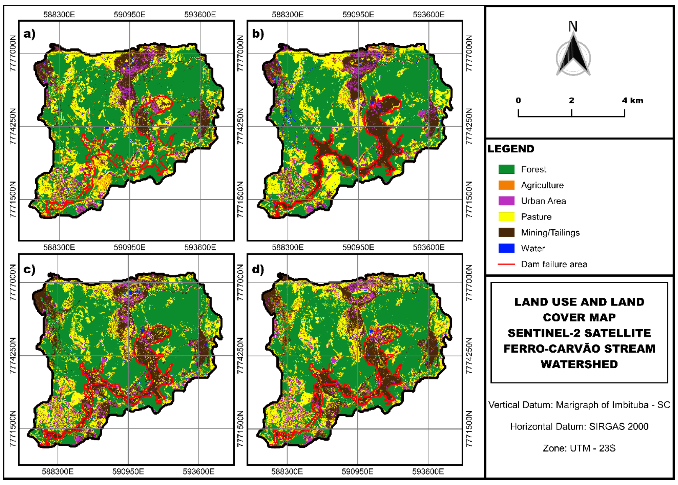
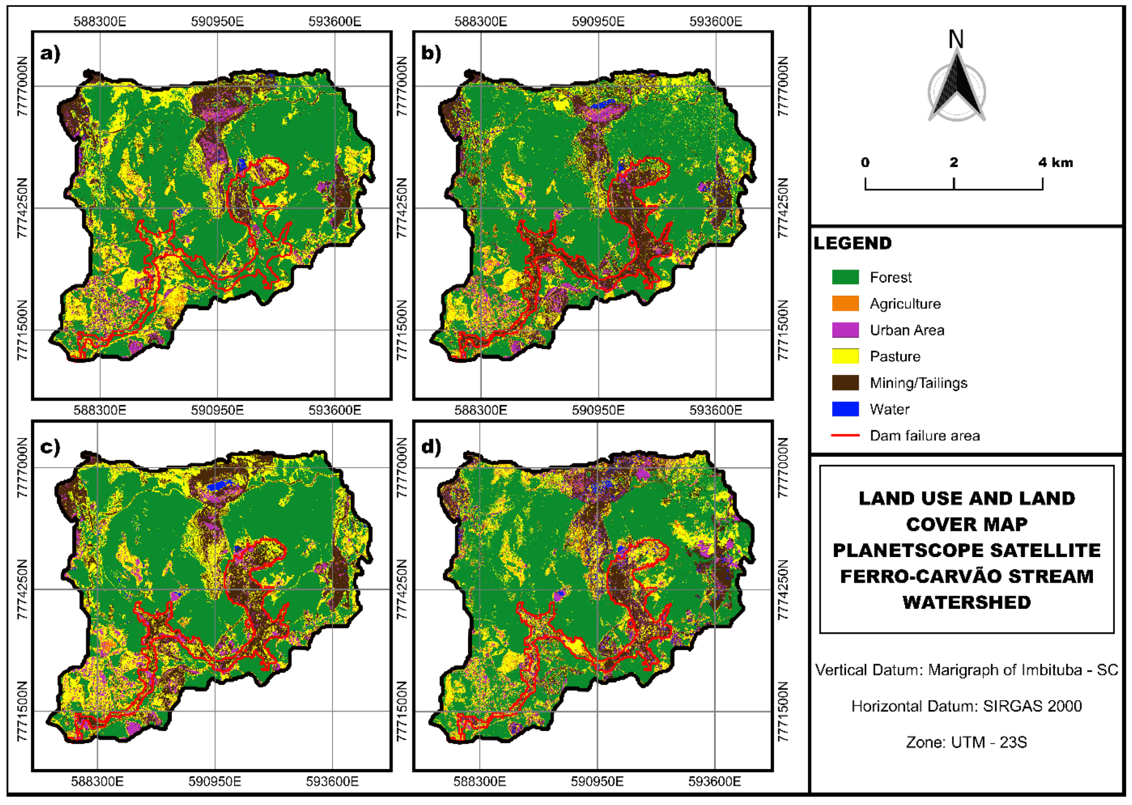
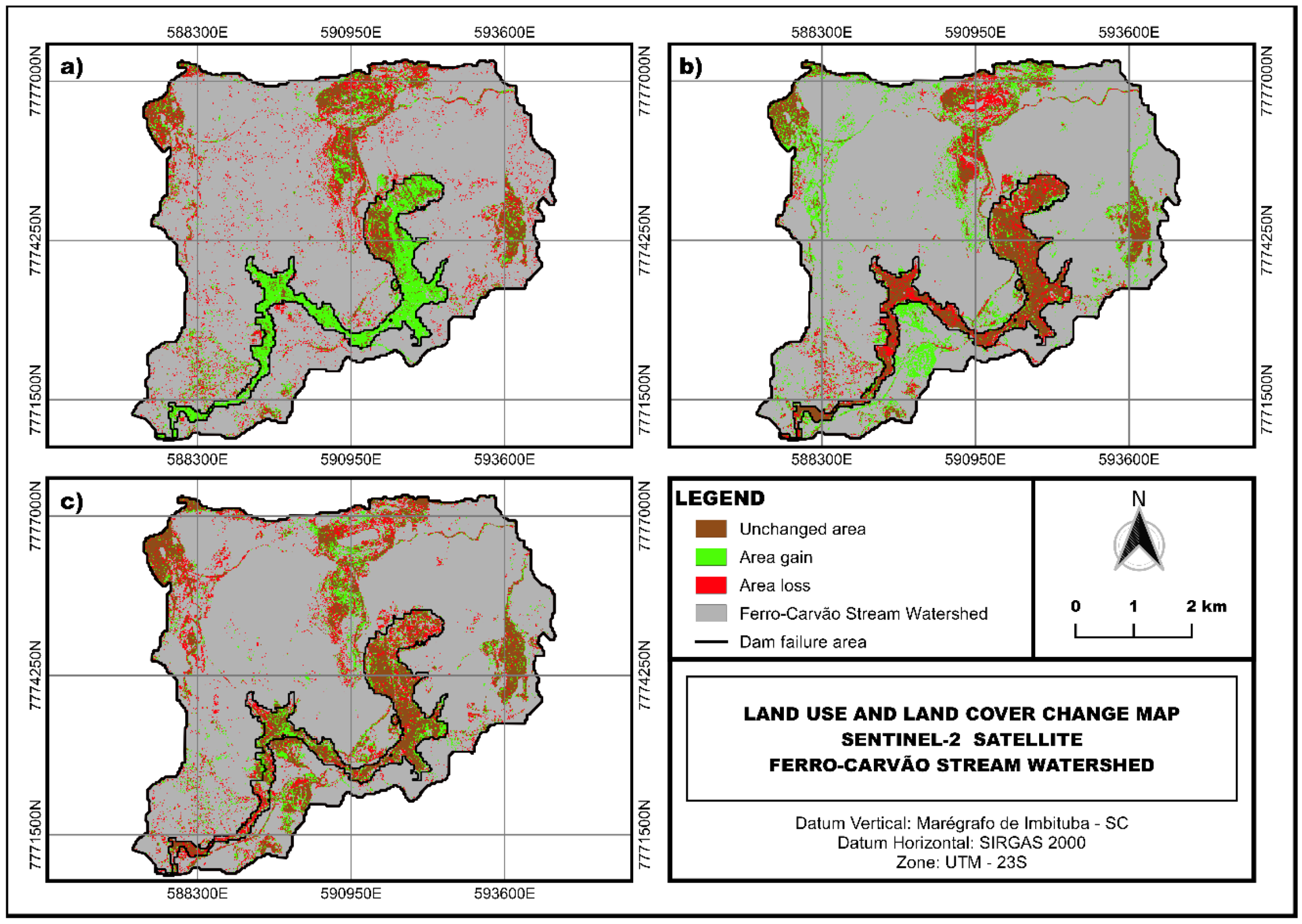
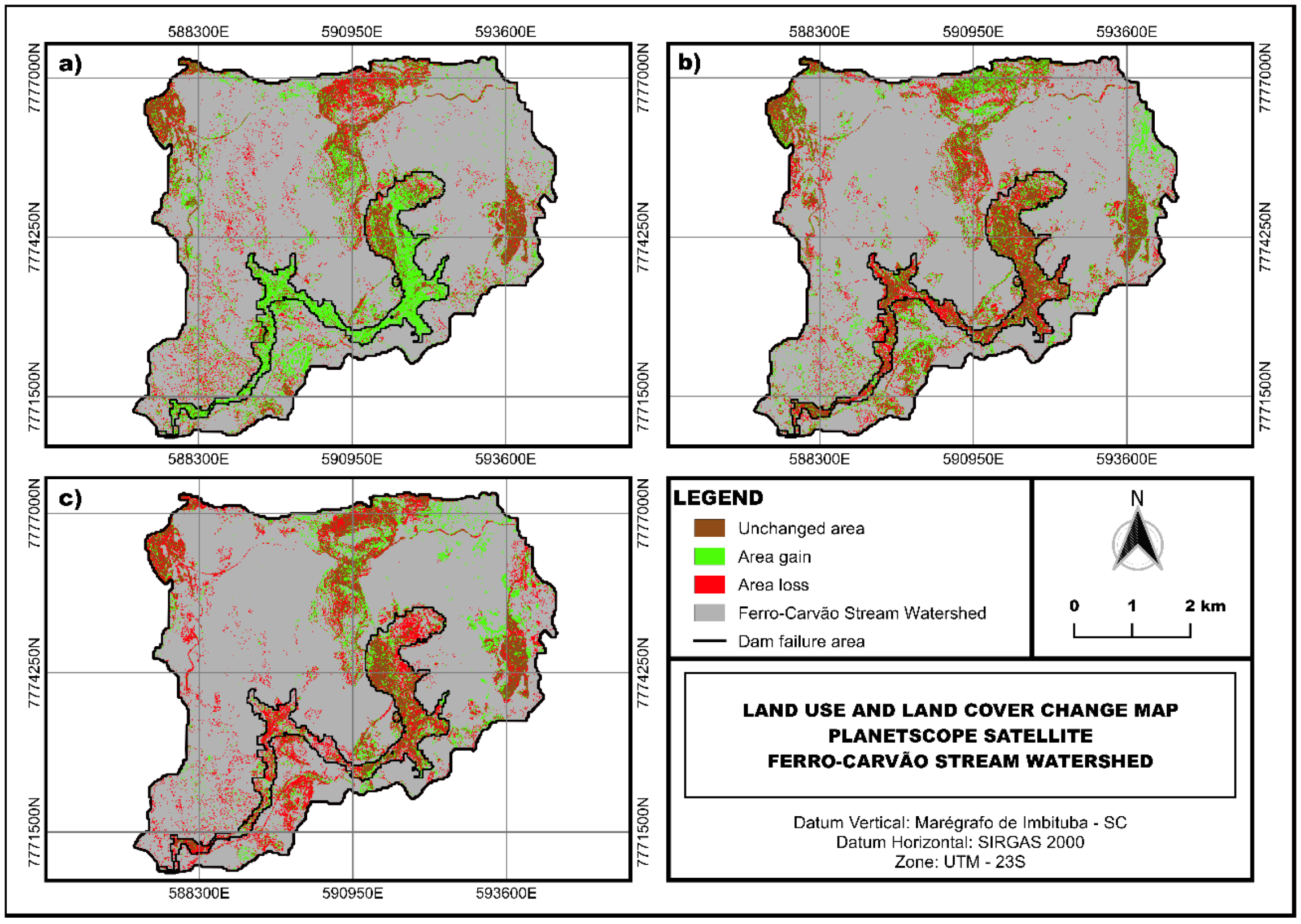
3.2. Changes in LULC Classes in the Failure Zone and Their Impacts

The failure of the B1 tailings dam in Brumadinho released debris and mud flows that covered flat low-lying areas around the Ferro-Carvão stream, where a vast swath of vegetation was destroyed, as well as agropastoral areas and water bodies [97]. This accident resulted in 270 deaths and 11.7 mm3 of tailings spilled, destroying agricultural zones, native vegetation, and entire neighborhoods in Brumadinho, and altering the morphology of the Ferro-Carvão stream over a 10 km stretch until reaching the streambed of the Paraopeba River [98,99,100].
The Ferro-Carvão stream failure zone (3.208 km2) showed changes in LULC and landscape between 2018 and 2019 (before and after failure), detected on L8—30 m, S2—10 m, and P—4.77 m images (Tables S2–S7 of the Supplementary Materials and Figure 4, Figure 5, Figure 6, Figure 7, Figure 8 and Figure 9). They revealed an increase in mining/tailings areas (1.757; 1.898; 1449 km2) and a decrease in native forests (1.149; 1.229; 1.138 km2), pastures (0.461; 0.592; 0.427 km2), and agricultural land (0.007; 0.056; 0.001 km2). The increased cover of agro-silvo-pastoral zones by tailings exacerbated environmental deterioration, impacting the region’s economy [98]. Mendes et al. [20] used PLS-PM to model environmental deterioration caused by the dam’s failure, demonstrating that tailings compromised water quality. Oliveira et al. [101] also observed that the failure zone would be covered by more than 3 km2 of sediments, destroying 1.4 km2 of native vegetation and 0.4 km2 of agropastoral lands. Between 2019 and 2020 (after failure), there was a decline in mining/tailings areas, likely due to the mechanical removal and mobilization of the tailings (0.262; 0.502; 0.366 km2), which favored the increase in pasture cover (0.102; 0.347; 0.433 km2) and forests (0.032; 0.032; 0.121 km2). Between 2020 and 2021, there was an increase in the forest (0.029; 0.089; 0.039 km2) and agricultural areas (0.032; 0.219; 0.112 km2) and a decline in their mining/tailings counterparts (0.296; 0.110; 0.082 km2). This revealed that the decrease in tailings areas has favored environmental recovery. Thus, the classes that changed the most before and after failure were forests and mining/tailings, which were the most responsible for altering LULC. Landscape changes also affected the biological environment, which has suffered significant damage, such as ichthyofauna, causing losses in nursery and breeding grounds and leading to the extinction of some species [102]. It is important to note that changes in biological communities, added to the other impacts, reduce the predator–prey ratio and consequently increase the number of populations [13]. Another consequence of changes in LULC was the direct impact on potable water sources after failure, whereby local use in the watershed was restricted and required an alternate water supply for the population [103]. Another impact of the accident was observed in the soil, namely the immediate impermeability of the surface layer and the loss of plant cover, causing a decline in rainwater infiltration. The tailings contained silts and clays with high levels of Fe, Mn, and P [104]. Soil barium and cobalt concentrations also increased in the region [104]. Excessive soil barium levels may also alter microbial biodiversity [105]. Cobalt occurs naturally in soils, where high concentrations are caused mainly by anthropic activities, thereby contaminating the soil [106]. In the study region, this element may originate in mafic rocks, which are associated with iron in geochemical processes [107]. The failure also affected Brumadinho’s economy, where 60% of revenues were from local mining activity [108].

3.3. Changes in LULC Classes Outside the Failure Zone

Land cover is in constant change and is caused by natural or anthropic alterations. The B1 dam disaster was a transforming agent of the landscape, primarily in terms of the impacts on existing land use and land cover [101]. Thus, this comparative study of LULC outside the failure zone (30.062 km2) was also relevant because it helped the analysis of the environmental dynamics in the watershed. This region exhibited changes in LULC, identified on L8—30 m, S2—10 m, and P—4.7 m images (Tables S2–S7 of the Supplementary Materials and Figure 4, Figure 5, Figure 6, Figure 7, Figure 8 and Figure 9). For the first analysis period of 2018-2019, there was an increase in the forest (0.229; 0.862; 1.481 km2) and agricultural areas (0.052; 0.049; 0.004) and a decline in the mining area diagnosed in L8—30 m and S2—10 m images (0.813; 1.051 km2). Thus, agricultural areas tended to increase outside the failure zone due to higher cover and incentives. According to SENAR [109], over a 2-year period, agriculture recovered in the region, with a 50% increase in income and a 455% increase in food production. Between 2019 and 2020, mining/tailings areas increased outside the failure area (0.972; 1.541; 0.111 km2). This may be due to removal operations and failure zone tailings screening performed by the Vale SA company, creating temporary tailings deposits. A large part of these tailings was stored in two piles, the Menezes Pile III and União Pile, which were both in areas belonging to Vale S.A [110]. The mining/tailings area declined in 2020–21 (0.570; 0.637; 0.893 km2), possibly due to the definitive tailings retention in the Cava do Feijão valley, which was initiated in February 2020 [110]. After the tailings piles were removed from outside the failure zone, new pasture areas were identified on L8—30 m and S2—10 m images (1.057; 0.126 km2).

4. Conclusions

LULC diagnosis is an excellent environmental management tool, favoring decision-making by the managing, legal, and political authorities. The orbital image performance of three satellites was assessed at different spatial and spectral resolutions in constructing LULC in an area affected by the mine tailings dam failure that occurred in Brumadinho, Minas Gerais state, Brazil.
LULC was mapped in a script built on the GEE platform using six random forest classifier classes of pure images obtained from the Landsat, Sentile, and PlanetScope satellites. The results showed that the spectral resolution of the images influenced classification accuracy, where higher values were found in the Landsat (30 m) and Sentinel (10 m) satellites because they have more spectral bands than PlanetScope (4.7 m). As such, improved classification accuracy is associated with the spatial and spectral resolution, where Landsat and Sentinel-2 were superior to PlanetScope in classification accuracy. Overall (OA) and class accuracy (F-score) performed well for all the satellites, with values > 93.9 and 85%, respectively. Matthew’s correlation coefficient (MCC) performed well in multiclass classification, with values > 57%, suggesting that the LULC obtained in the study is applicable in the space–time scales. Thus, in this study, all the satellite images exhibited LULC classification capacity in the watershed where the dam failed.
The evaluation of the accuracy of LULC mapping on a time scale in areas affected by tailings dam failures showed that the PRM technique associated with satellite images with different spatial resolutions and the random forest (RF) model in the GEE can be successfully used in the classification of these areas. In addition, the performance of the model was accurate using visible and near-infrared spectrum bands and without the need for image resampling, using bands with the same spatial resolution. This action is shown to simplify the data pre-processing process specifically applied to the LULC diagnosis, enabling the identification of changes to the environment caused by the rupture of a mining tailings dam.
The use of the same training dataset in dam failure zones presented a viable alternative to classifying temporal images in different spatial resolutions. This can reduce the time and cost involved in collecting new training data and favor faster diagnosis. However, it is important to emphasize that this use can affect the accuracy of the classification, mainly in areas with subtle changes in land cover. Therefore, it is important to evaluate the accuracy of the new research. This involves adopting different time intervals and spatial resolutions and checking the results in different scenarios before adopting this approach as common practice in disaster areas. Another issue to be addressed in a forthcoming scientific work would be the implementation of an outlier analysis of the data collected with the purpose of carrying out a comparative evaluation of the accuracy of LULC.
As such, after the failure, mining/tailings areas increased in the Ferro-Carvão stream failure zone, while their native forest, pasture, and agricultural counterparts declined, exacerbating environmental deterioration. The environment recovered in subsequent years due to mechanical tailings removal and mobilization, thereby decreasing mining/tailings areas and favoring an increase in surrounding pasture and forest areas.

Supplementary Materials

The following supporting information can be downloaded at https://www.mdpi.com/article/10.3390/su15086949/s1, Figure S1: Confusion matrices for each class processed on land use and land cover for the Landsat 8, Sentinel-2, and PlanetScope satellites; Figure S2: Overall accuracy estimated for Landsat 8 (L8—30 m), Sentinel 2 (S2—10 m), and PlanetScope (p—4.7 m) images for 2018 (before failure) and 2019, 2020, and 2021 (after failure); Figure S3: Producer accuracy estimated for Landsat 8, Sentinel 2, and PlanetScope images for 2018 (before failure) and 2019, 2020, and 2021 (after failure); Figure S4: User accuracy estimated for Landsat 8, Sentinel 2, and PlanetScope images for 2018 (before failure) and 2019, 2020, and 2021 (after failure); Figure S5: F-score estimated for Landsat 8, Sentinel 2, and PlanetScope images for 2018 (before failure) and 2019, 2020, and 2021 (after failure); Figure S6. Matthew’s correlation coefficient (MCC) estimated for Landsat 8, Sentinel 2, and PlanetScope images for 2018 (before failure) and 2019, 2020, and 2021 (after failure); Table S1: Producer (PA) and user accuracy (UA) for each class processed on land use and land cover maps for Landsat 8, Sentinel-2, and PlanetScope satellites; Table S2: Diagnosis of land use and land cover based on Landsat 8 images, before and after failure. Authors’ archive, 2022; Table S3: Diagnosis of land use and land cover based on Sentinel-2 images, before and after failure. Authors’ collection, 2022; Table S4: Diagnosis of land use and land cover based on PlanetScope images, before and after failure. Authors’ collection, 2022; Table S5: Simplified diagnosis of the difference in land use and land cover area based on Landsat 8 images, before and after failure; Table S6: Simplified diagnosis of the difference in land use and land cover area based on Sentinel-2 images, before and after failure; Table S7: Simplified diagnosis of the difference in land use and land cover area based on PlanetScope images, before and after failure.

Author Contributions

Conceptualization, R.F.d.V.J. and M.M.A.P.d.M.S.; Methodology, C.R.M.F., R.F.d.V.J., M.M.A.P.d.M.S. and G.d.S.R.; Software, G.d.S.R.; Validation, R.F.d.V.J. and M.M.A.P.d.M.S.; Formal analysis, T.C.T.P., M.C.d.M., C.A.V., F.A.L.P. and L.F.S.F.; Investigation, C.R.M.F.; Resources, T.C.T.P., M.C.d.M. and L.F.S.F.; Data curation, C.R.M.F.; Writing—original draft, C.R.M.F.; Writing—eview & editing, R.G.M. and F.A.L.P.; Visualization, M.M.A.P.d.M.S., R.G.M. and G.d.S.R.; Supervision, T.C.T.P., C.A.V. and F.A.L.P.; Project administration, F.A.L.P. and L.F.S.F.; Funding acquisition, M.C.d.M. and C.A.V. All authors have read and agreed to the published version of the manuscript.

Funding

This study was funded by contract No. 5500074952/5500074950/5500074953, signed between the Vale S.A. company and the following research institutions: Fundação de Apoio Universitário (Brazil); Universidade de Trás-os-Montes e Alto Douro (Portugal); and Fundação para o Desenvolvimento da Universidade Estadual Paulista Júlio de Mesquita Filho (Brazil). Renato Farias do Valle Junior received a productivity grant from the CNPq—Conselho Nacional de Desenvolvimento Científico e Tecnológico (Brazil). For the author integrated with the CITAB research center (Portugal), this work was further supported by National Funds of FCT—Fundação para a Ciência e Tecnologia, under project UIDB/04033/2020. The author integrated with the CITAB research center is also integrated with the Inov4Agro—Institute for Innovation, Capacity Building, and Sustainability of Agri-food Production. The Inov4Agro is an Associate Laboratory composed of two R&D units (CITAB and GreenUPorto). For the author integrated with the CQVR, the research was supported by the Portuguese National Funds of FCT—Fundação para Ciência e Tecnologia, projects UIDB/00616/2020 and UIDP/00616/2020, and Brazilian funds of CAPES—Fundação Coordenação de Aperfeiçoamento de Pessoal de Nível Superior, scholarship Proc. No. 88887.716753/2022–00 and PRINT—Programa Institucional de Internacionalização—CAPES/PRINT—Edital No. 41/2017. With regard to this author, the publication also contributes to executing the working plan approved by the postdoc program in Agronomy (soil science) of Universidade Estadual Paulista Júlio Mesquita Filho (UNESP, campus Jaboticabal), to which Fernando A.L. Pacheco is affiliated during the January—June 2023 period.

Data Availability Statement

Some tables and figures mentioned in the text (Tables S1–S7; Figures S1–S6) are provided as Supplementary Materials.

Conflicts of Interest

The authors declare no conflict of interest. The funders had no role in the design of the study; in the collection, analyses, or interpretation of data; in the writing of the manuscript, or in the decision to publish the results.

References

  1. Velasquez, H.I.; Orozco Loaiza, C.A.; Hasenstab, C.; Cano, N.A. Evaluation of the extractive gold process: Open-pit mining through exergy analysis. J. Sustain. Min. 2020, 19, 3. [Google Scholar] [CrossRef]
  2. Lyu, Z.; Chai, J.; Xu, Z.; Qin, Y.; Cao, J. A comprehensive review on reasons for tailings dam failures based on case history. Adv. Civ. Eng. 2019, 2019, 4159306. [Google Scholar] [CrossRef]
  3. Hamilton, A.K.; Laval, B.E.; Petticrew, E.L.; Albers, S.J.; Allchin, M.; Baldwin, S.A.; Carmack, E.C.; Déry, S.J.; French, T.D.; Granger, B.; et al. Seasonal Turbidity Linked to Physical Dynamics in a Deep Lake Following the Catastrophic 2014 Mount Polley Mine Tailings Spill. Water Resour. Res. 2020, 56, e2019WR025790. [Google Scholar] [CrossRef]
  4. Owusu, K.; Obour, P.B.; Nkansah, M.A. Downstream effects of dams on livelihoods of river-dependent communities: The case of Ghana’s Kpong Dam. Geogr. Tidsskr. Dan. J. Geogr. 2017, 117, 1–10. [Google Scholar] [CrossRef]
  5. Aires, U.R.V.; Santos, B.S.M.; Coelho, C.D.; da Silva, D.D.; Calijuri, M.L. Changes in land use and land cover as a result of the failure of a mining tailings dam in Mariana, MG, Brazil. Land Use Policy. 2018, 70, 63–70. [Google Scholar] [CrossRef]
  6. Islam, K.; Murakami, S. Global-scale impact analysis of mine tailings dam failures: 1915–2020. Glob. Environ. Change 2021, 70, 102361. [Google Scholar] [CrossRef]
  7. Sitharam, T.G.; Hegde, A. Stability analysis of rock-fill tailing dam: An Indian case study. Int. J. Geotech. Eng. 2016, 11, 332–342. [Google Scholar] [CrossRef]
  8. Furlan, J.P.R.; Santos, L.D.R.; Moretto, J.A.S.; Ramos, M.S.; Gallo, I.F.L.; Alves, G.A.D.; Paulelli, A.C.; Rocha, C.C.S.; Cesila, C.A.; Gallimberti, M.; et al. Occurrence and abundance of clinically relevant antimicrobial resistance genes in environmental samples after the Brumadinho dam disaster, Brazil. Sci. Total Environ. 2020, 726, 138100. [Google Scholar] [CrossRef]
  9. Lebron, Y.A.R.; Moreira, V.R.; Drumond, G.P.; Silva, M.M.; Bernardes, R.O.; Santos, L.V.S.; Jacob, R.S.; Viana, M.M.; Vasconcelos, C.K.B. Graphene oxide for efficient treatment of real contaminated water by mining tailings: Metal adsorption studies to Paraopeba river and risk assessment. Chem. Eng. J. Adv. 2020, 2, 100017. [Google Scholar] [CrossRef]
  10. Davies, M.P. Tailings Impoundment Failures: Are Geotechnical Engineers Listening? Waste GEO Tech. 2002, 20, 31–36. [Google Scholar]
  11. Vrhovnik, P.; Dolenec, T.; Serafimovski, T.; Dolenec, M.; Šmuc, N.R. The occurrence of heavy metals and metalloids in surficial lake sediments before and after a tailings dam failure. Pol. J. Environ. Stud. 2013, 22, 1525–1538. [Google Scholar]
  12. Da Silva, K.B.C.; Ribeiro, K.D.R. Ruptura em barragens de rejeitos: Uma abordagem sobre monitoramento e fiscalização: Breaks in waste dams: An approach to monitoring and surveillance. IGNIS Periódico Científico de Arquitetura e Urbanismo Engenharias e Tecnologia de Informação 2020, 9, 17–34. [Google Scholar]
  13. Oliveira, C.F.; do Valle Junior, R.F.; Valera, C.A.; Rodrigues, V.S.; Sanches Fernandes, L.F.; Pacheco, F.A.L. The modeling of pasture conservation and of its impact on stream water quality using Partial Least Squares-Path Modeling. Sci. Total Environ. 2019, 697, 134081. [Google Scholar] [CrossRef]
  14. Felizardo, J.P.; Muniz, M.C.; Vezzone, M.; Cardoso, R.P.; Wasserman, J.; Padilla, R.; Migliori, A.; Anjos, R.M. Sources of sedimentary organic matter and assessment of heavy-metal levels in estuarine sediments after Fundão dam breach. Estuar. Coast. Shelf Sci. 2021, 261, 107507. [Google Scholar] [CrossRef]
  15. Guardian, 2019. Brazilian Mining Company to Pay out £86m for Disaster that Killed Almost 300 People. Available online: https://www.theguardian.com/world/2019/jul/16/vale-brazil-mining-dam-collapse-brumadinho (accessed on 20 November 2022).
  16. Pereira, L.F.; Cruz, G.B.; Guimarães, R.M.F. Impactos do rompimento da barragem de rejeitos de Brumadinho, Brasil: Uma análise baseada nas mudanças de cobertura da terra. J. Environ. Anal. Prog. Pernamb. 2019, 4, 122–129. [Google Scholar] [CrossRef]
  17. Thompson, F.; Oliveira, B.C.; Cordeiro, M.C.; Masi, B.P.; Rangel, T.P.; Paz, P.; Freitas, T.; Lopes, G.; Silva, B.S.; Cabral, A.; et al. Severe impacts of the Brumadinho dam failure (Minas Gerais, Brazil) on the water quality of the Paraopeba River. Sci. Total Environ. 2020, 705, 135914. [Google Scholar] [CrossRef]
  18. Do Carmo, F.F.; Kamino, L.H.Y.; Junior, R.T.; de Campos, I.C.; do Carmo, F.F.D.; Silvino, G.; de Castro, K.J.d.S.X.; Mauro, M.L.; Rodrigues, N.U.A.; Miranda, M.P.d.S.; et al. Fundão tailings dam failures: The environment tragedy of the largest technological disaster of Brazilian mining in global context. Perspect. Ecol. Conserv. 2017, 15, 145–151. [Google Scholar] [CrossRef]
  19. Gomes, L.E.O.; Correa, L.B.; Sá, F.; Neto, R.R. The impacts of the Samarco mine tailing spill on the Rio Doce estuary, Eastern Brazil. Mar. Pollut. Bull. 2017, 120, 28–36. [Google Scholar] [CrossRef]
  20. Mendes, R.G.; Valle Junior, R.F.; Silva, M.M.A.P.M.; Sanches Fernandes, L.F.; Fernandes, A.C.P.; Pissarra, T.C.T.; Melo, M.C.; Valera, C.A.; Pacheco, F.A.L. A partial least squares-path model of causality among environmental deterioration indicators in the dry period of Paraopeba River after the rupture of B1 tailings dam in Brumadinho (Minas Gerais, Brasil). Environ. Pollut. 2022, 306, 119341. [Google Scholar] [CrossRef]
  21. Lozano, F.A.E. Seleção de Locais Para Barragens de Rejeitos Usando o Método de Análise Hierárquica. Master’s Thesis, Escola Politécnica da Universidade de São Paulo, São Paulo, SP, Brazil, 2006. [Google Scholar]
  22. Rotta, L.H.S.; Alcântara, E.; Park, E.; Negri, R.G.; Lin, Y.N.; Bernardo, N.; Mendes, T.S.G.; Souza Filho, C.R. The 2019 Brumadinho tailings dam collapse: Possible cause and impacts of the worst human and environmental disaster in Brazil. Int. J. Appl. Earth Obs. Geoinf. 2020, 90, 102119. [Google Scholar] [CrossRef]
  23. Pinto-Coelho, R.M.; Vieira, E.M.; Pio, F.P.B.; de Almeira, V.F.; Santos, R.E. Atlas das barragens de mineração em Minas Gerais. Cad. Geogr. 2021, 31, 260. [Google Scholar] [CrossRef]
  24. Grimalt, J.O.; Ferrer, M.; Macpherson, E. The mine tailing accident in Aznalcollar. Sci. Total Environ. 1999, 242, 3–11. [Google Scholar] [CrossRef] [PubMed]
  25. Belgiu, M.; Drăguţ, L. Random forest in remote sensing: A review of applications and future directions. ISPRS J. Photogramm. Remote Sens. 2016, 114, 24–31. [Google Scholar] [CrossRef]
  26. Phalke, A.R.; Özdoğan, M.; Thenkabail, P.S.; Erickson, T.; Gorelick, N.; Yadav, K.; Congalton, R.G. Mapping croplands of Europe, Middle East, Russia, and Central Asia using Landsat, Random Forest, and Google Earth Engine. ISPRS J. Photogramm. Remote Sens. 2020, 167, 104–122. [Google Scholar] [CrossRef]
  27. Zhao, Y.; Zhu, W.; Wei, P.; Fang, P.; Zhang, X.; Yan, N.; Liu, W.; Zhao, H.; Wu, Q. Classification of Zambian grasslands using random forest feature importance selection during the optimal phonological period. Ecol. Indic. 2022, 135, 108529. [Google Scholar] [CrossRef]
  28. Archer, K.J. Empirical characterization of random forest variable ımportance measure, computational statistical data analysis. Comput. Stat. Data Anal. 2008, 52, 2249–2260. [Google Scholar] [CrossRef]
  29. Akar, O.; Güngör, O. Classification of multispectral images using Random Forest algorithm. J. Geod. Geoinf. 2012, 1, 105–112. [Google Scholar] [CrossRef]
  30. Zounemat-Kermani, M.; Rajaee, T.; Ramezani-Charmahineh, A.; Adamowski, J. Estimating the aeration coefficient and air demand in bottom outlet conduits of dams using GEP and decision tree methods. Flow Meas. Instrum. 2016, 54, 9–19. [Google Scholar] [CrossRef]
  31. Kang, C.S.; Kanniah, K.D. Land use and land cover change and its impact on river morphology in Johor River Basin, Malaysia. J. Hydrol. Reg. Stud. 2022, 41, 101072. [Google Scholar] [CrossRef]
  32. Huang, X.; Wang, H.; Xue, W.; Xiang, S.; Huang, H.; Meng, L.; Ma, G.; Ullah, A.; Zhang, G. Study on time-temperature-transformation diagrams of stainless steel using machine-learning approach. Comput. Mater. Sci. 2020, 171, 109282. [Google Scholar] [CrossRef]
  33. Huang, X.; Wang, H.; Xue, W.; Ullah, A.; Xiang, S.; Huang, H.; Meng, L.; Ma, G.; Zhang, G. A combined machine learning model for the prediction of time-temperature-transformation diagrams of high-alloy steels. J. Alloys Compd. 2020, 823, 153694. [Google Scholar] [CrossRef]
  34. Geng, X.; Mao, X.; Wu, H.H.; Wang, S.; Xue, W.; Zhang, G.; Ullah, A.; Wang, H. A hybrid machine learning model for predicting continuous cooling transformation diagrams in welding heat-affected zone of low alloy steels. J. Mater. Sci. Technol. 2022, 107, 207–215. [Google Scholar] [CrossRef]
  35. Geng, X.; Wang, H.; Ullah, A.; Xue, W.; Xiang, S.; Meng, L.; Ma, G. Prediction of Continuous Cooling Transformation Diagrams for Ni-Cr-Mo Welding Steels via Machine Learning Approaches. JOM 2020, 72, 3926–3934. [Google Scholar] [CrossRef]
  36. Gorelick, N.; Hancher, M.; Dixon, M.; Ilyushchenko, S.; Thau, D.; Moore, R. Google Earth Engine: Planetary-scale geospatial analysis for everyone. Remote Sens. Environ. 2017, 202, 18–27. [Google Scholar] [CrossRef]
  37. Mutanga, O.; Kumar, L. Google Earth Engine Applications. Remote Sens. 2019, 11, 591. [Google Scholar] [CrossRef]
  38. Wang, C.; Shao, F.; Zhang, Z.; Sui, Y.; Li, S. Mining the features of spatial adjacency relationships to improve the classification of high resolution remote sensing images based on complex network. Appl. Soft Comput. J. 2021, 102, 107089. [Google Scholar] [CrossRef]
  39. Vuolo, F.; Neuwirth, M.; Immitzer, M.; Atzberger, C.; Ng, W.-T. How much does multi-temporal Sentinel-2 data improve crop type classification? Int. J. Appl. Earth Obs. Geoinf. 2018, 72, 122–130. [Google Scholar] [CrossRef]
  40. Chaves, M.E.D.; Picoli, M.C.A.; Sanches, I.D. Recent applications of Landsat 8/OLI and Sentinel-2/MSI for land use and land cover mapping: A systematic review. Remote Sens. 2020, 12, 3062. [Google Scholar] [CrossRef]
  41. Defourny, P.; Bontemps, S.; Bellemans, N.; Cara, C.; Dedieu, G.; Guzzonato, E.; Hagolle, O.; Inglada, J.; Nicola, L.; Rabaute, T.; et al. Near real-time agriculture monitoring at national scale at parcel resolution: Performance assessment of the Sen2-Agri automated system in various cropping systems around the world. Remote Sens. Environ. 2019, 221, 551–568. [Google Scholar] [CrossRef]
  42. Chen, J.; Chen, J.; Liao, A.; Cao, X.; Chen, L.; Chen, X.; He, C.; Han, G.; Peng, S.; Lu, M.; et al. Global land cover mapping at 30 m resolution: A POK-based operational approach. ISPRS J. Photogramm. Remote Sens. 2015, 103, 7–27. [Google Scholar] [CrossRef]
  43. Abutaleb, K.; Newete, S.W.; Mangwanya, S.; Adam, E.; Byrne, M.J. Mapping eucalypts trees using high resolution multispectral images: A study comparing WorldView 2 vs. SPOT 7. Egypt. J. Remote Sens. Space Sci. 2021, 24, 333–342. [Google Scholar] [CrossRef]
  44. Hu, Z.; Shi, T.; Wang, C.; Li, Q.; Wu, G. International Journal of Applied Earth Observations and Geoinformation Scale-sets image classification with hierarchical sample enriching and automatic scale selection. Appl. Earth Obs. Geoinf. 2021, 105, 102605. [Google Scholar] [CrossRef]
  45. Lin, C. Effects of atmospheric correction and pansharpening on LULC classification accuracy using WorldView-2 imagery. Inf. Process. Agric. 2015, 2, 25–36. [Google Scholar] [CrossRef]
  46. Rufin, P.; Bey, A.; Picoli, M.; Meyfroidt, P. Large-area mapping of active cropland and short-term fallows in smallholder landscapes using PlanetScope data. Int. J. Appl. Earth Obs. Geoinf. 2022, 112, 102937. [Google Scholar] [CrossRef] [PubMed]
  47. Poortinga, A.; Thwal, N.S.; Khanal, N.; Mayer, T.; Bhandari, B.; Markert, K.; Nicolau, A.P.; Dilger, J.; Tenneson, K.; Clinton, N.; et al. Mapping sugarcane in Thailand using transfer learning, a lightweight convolutional neural network, NICFI high resolution satellite imagery and Google Earth Engine. ISPRS Open J. Photogramm. Remote Sens. 2021, 1, 100003. [Google Scholar] [CrossRef]
  48. Pascual, A.; Tupinambá-Simões, F.; Guerra-Hernández, J.; Bravo, F. High-resolution planet satellite imagery and multi-temporal surveys to predict risk of tree mortality in tropical eucalypt forestry. J. Environ. Manag. 2022, 310, 114804. [Google Scholar] [CrossRef]
  49. Cheng, Y.; Vrieling, A.; Fava, F.; Meroni, M.; Marshall, M.; Gachoki, S. Remote Sensing of Environment Phenology of short vegetation cycles in a Kenyan rangeland from PlanetScope and Sentinel-2. Remote Sens. Environ. 2020, 248, 112004. [Google Scholar] [CrossRef]
  50. Sadeh, Y.; Zhu, X.; Dunkerley, D.; Walker, J.P.; Zhang, Y.; Rozenstein, O.; Manivasagam, V.S.; Chenu, K. Fusion of Sentinel-2 and PlanetScope time-series data into daily 3 m surface reflectance and wheat LAI monitoring. Int. J. Appl. Earth Obs. Geoinf. 2021, 96, 102260. [Google Scholar] [CrossRef]
  51. Mansaray, A.S.; Dzialowski, A.R.; Martin, M.E.; Wagner, K.L.; Gholizadeh, H.; Stoodley, S.H. Comparing planetscope to landsat-8 and sentinel-2 for sensing water quality in reservoirs in agricultural watersheds. Remote Sens. 2021, 13, 1847. [Google Scholar] [CrossRef]
  52. Kpienbaareh, D.; Sun, X.; Wang, J.; Luginaah, I.; Kerr, R.B.; Lupafya, E.; Dakishoni, L. Crop type and land cover mapping in northern malawi using the integration of sentinel-1, sentinel-2, and planetscope satellite data. Remote Sens. 2021, 13, 700. [Google Scholar] [CrossRef]
  53. Moraga, J.; Gurkan, G.; Duzgun, S. Monitoring the impacts of a tailings dam failure using satellite images. arXiv 2021. [Google Scholar] [CrossRef]
  54. Syifa, M.; Park, S.J.; Achmad, A.R.; Lee, C.W.; Eom, J.; Eom, J. Flood mapping using remote sensing imagery and artificial intelligence techniques: A case study in Brumadinho, Brazil. J. Coast. Res. 2019, 90, 197–204. [Google Scholar] [CrossRef]
  55. Noi Phan, T.; Kuch, V.; Lehnert, L. Land cover classification using google earth engine and random forest classifier-the role of image composition. Remote Sens. 2020, 12, 2411. [Google Scholar] [CrossRef]
  56. Barbosa, C.C.F.; de Moraes Novo, E.M.L.; Martins, V.S. (Eds.) Introdução ao sensoriamento remoto de sistemas aquáticos: Princípios e aplicações. In Instituto Nacional de Pesquisas Espaciais, 1st ed; Instituto Nacional de Pesquisas Espaciais: São José dos Campos, SP, Brazil, 2019. [Google Scholar]
  57. Marinho, R.R.; Harmel, T.; Martinez, J.M.; Junior, N.P.F. Spatiotemporal dynamics of suspended sediments in the negro river, amazon basin, from in situ and sentinel-2 remote sensing data. ISPRS Int. J. Geo-Inf. 2021, 10, 86. [Google Scholar] [CrossRef]
  58. Aires, U.R.V.; da Silva, D.D.; Fernandes Filho, E.I.; Rodrigues, L.N.; Uliana, E.M.; Amorim, R.S.S.; Ribeiro, C.B.d.M.; Campos, J.A. Modeling of surface sediment concentration in the Doce River basin using satellite remote sensing. J. Environ. Manag. 2022, 323, 116207. [Google Scholar] [CrossRef]
  59. SACE—Sistema de Alerta de Eventos Críticos. 2021. Available online: http://www.cprm.gov.br/sace/index_rio_paraopeba.php (accessed on 18 November 2022).
  60. Du, Z.; Ge, L.; Ng, A.H.M.; Zhu, Q.; Finbarr, G.H.; Zhang, Q. Risk assessment for tailings dams in Brumadinho of Brazil using InSAR time series approach. Sci. Total Environ. 2020, 717, 137125. [Google Scholar] [CrossRef]
  61. Eduardo, C.C.; Felippe, M.F.; da Silva, T.M. Proposta Metodológica para Mapeamento de Relevos Tecnogênicos em Áreas de Desastres Ambientais. Espaço Aberto. 2021, 11, 5–26. [Google Scholar] [CrossRef]
  62. Durães, M.F. Caracterização e Avaliação do Estresse Hidrológico da Bacia do Rio Paraopeba, Por Meio de Simulação Chuva-vazão de Cenários Atuais e Prospectivos de Ocupação e Uso do Solo Utilizando Um Modelo Hidrológico Distribuído. Master’s Thesis, Universidade Federal de Minas Gerais, Belo Horizonte, MG, Brazil, 2010. [Google Scholar]
  63. Baltazar, O.F.; Baars, F.J.; Lobato, L.M.; Reis, L.B.; Achtschin, A.B.; Berni, G.V.; Silveira, V.D. Mapa Geológico do Quadrilátero Ferrífero na Escala 1: 50.000 com Nota Explicativa. In Projeto Geologia do Quadrilátero Ferrífero—Integração e Correção Cartográfica em SIG com Nota Explicativa; CODEMIG: Belo Horizonte, MG, Brazil, 2005. [Google Scholar]
  64. Relatório de Impacto Ambiental—RIMA. Projeto de Continuidade das Operações da Mina da Jangada de Córrego do Feijão: Municípios de Brumadinho e Sarzedo-MG; Nicho – Engenheiros Consultores, LTDA and Vale, SA: Belo Horizonte, MG, Brazil, 2017; p. 238. [Google Scholar]
  65. Companhia Brasileira de Projetos e Empreendimentos—COBRAPE. Plano Diretor da Bacia Hidrográfica do Rio Paraopeba; COBRAPE: São Paulo, SP, Brazil, 2020; p. 67. [Google Scholar]
  66. Bonanomi, J.; Tortato, F.R.; Gomes, R.S.R.; Penha, J.M.; Bueno, A.S.; Peres, C.A. Protecting forests at the expense of native grasslands: Land-use policy encourages open-habitat loss in the Brazilian cerrado biome. Perspect. Ecol. Conserv. 2019, 17, 26–31. [Google Scholar] [CrossRef]
  67. Alvares, C.A.; Stape, J.L.; Sentelhas, P.C.; Gonçalves, J.L.M.; Sparovek, G. Köppen’s classification map for Brazil. Meteorol. Z. 2013, 22, 711–728. Available online: http://www.lerf.eco.br/img/publicacoes/Alvares_etal_2014.pdf (accessed on 14 October 2022). [CrossRef]
  68. White, J.C.; Wulder, M.A.; Hobart, G.W.; Luther, J.E.; Hermosilla, T.; Griffiths, P.; Coops, N.C.; Hall, R.J.; Hostert, P.; Dyk, A.; et al. Pixel-based image compositing for large-area dense time series applications and science. Can. J. Remote Sens. 2014, 40, 192–212. [Google Scholar] [CrossRef]
  69. Griffiths, P.; Nendel, C.; Hostert, P. Intra-annual reflectance composites from Sentinel-2 and Landsat for national-scale crop and land cover mapping. Remote Sens. Environ. 2019, 220, 135–151. [Google Scholar] [CrossRef]
  70. Flood, N. Seasonal composite landsat TM/ETM+ Images using the medoid (a multi-dimensional median). Remote Sens. 2013, 5, 6481–6500. [Google Scholar] [CrossRef]
  71. Luo, C.; Zhang, X.; Meng, X.; Zhu, H.; Ni, C.; Chen, M.; Liu, H. Regional mapping of soil organic matter content using multitemporal synthetic Landsat 8 images in Google Earth Engine. Catena 2022, 209, 105842. [Google Scholar] [CrossRef]
  72. NICFI. Norway’s International Climate and Forest Initiative (NICFI). 2021. Available online: https://www.planet.com/products/monitoring/ (accessed on 15 November 2022).
  73. NICFI. NICFI Data Program Frequently Asked Questions. 2021. Available online: https://assets.planet.com/docs/NICFI_General_FAQs.pdf (accessed on 15 November 2022).
  74. Marta, S. Planet Imagery Product Specifications; Planet Labs: San Francisco, CA, USA, 2018; p. 91. Available online: https://assets.planet.com/docs/Combined-Imagery-Product-Spec-Dec-2018.pdf (accessed on 10 November 2022).
  75. Lillesand, T.M.; Kiefer, R.W. Remote Sensing and Image Interpretation; John Wiley e Sons Inc.: New York, NY, USA, 1994; p. 708. [Google Scholar]
  76. Sheykhmousa, M.; Mahdianpari, M.; Ghanbari, H.; Mohammadimanesh, F.; Ghamisi, P.; Homayouni, S. Support Vector Machine Versus Random Forest for Remote Sensing Image Classification: A Meta-Analysis and Systematic Review. IEEE J. Sel. Top. Appl. Earth Obs. Remote Sens. 2020, 13, 6308–6325. [Google Scholar] [CrossRef]
  77. Al-Saady, Y.; Merkel, B.; Al-Tawash, B.; Al-Suhail, Q. Land use and land cover (LULC) mapping and change detection in the Little Zab River Basin (LZRB), Kurdistan Region, NE Iraq and NW Iran. FOG Freib. Online Geosci. 2015, 43, 1–32. [Google Scholar]
  78. Weaver, J.; Moore, B.; Reith, A.; McKee, J.; Lunga, D. A comparison of machine learning techniques to extract human set-tlements from high resolution imagery. In Proceedings of the International Geoscience and Remote Sensing Symposium (IGARSS), Valencia, Spain, 22–27 July 2018. [Google Scholar] [CrossRef]
  79. Richard, K.; Abdel-Rahman, E.M.; Subramanian, S.; Nyasani, J.O.; Thiel, M.; Jozani, H.; Borgemeister, C.; Landmann, T. Maize cropping systems mapping using RapidEye observations in agro-ecological landscapes in Kenya. Sensors 2017, 17, 2537. [Google Scholar] [CrossRef]
  80. Matthews, B.W. Comparison of the predicted and observed secondary structure of T4 phage lysozyme. BBA—Protein Struct. 1975, 405, 442–451. [Google Scholar] [CrossRef]
  81. Chicco, D.; Jurman, G. The advantages of the Matthews correlation coefficient (MCC) over F1 score and accuracy in binary classification evaluation. BMC Genom. 2020, 21, 6. [Google Scholar] [CrossRef]
  82. Delgado, R.; Tibau, X.A. Why Cohen’s Kappa should be avoided as performance measure in classification. PLoS ONE 2019, 14, e0222916. [Google Scholar] [CrossRef]
  83. Congedo, L. Semi-Automatic Classification Plugin Documentation. Release 2016, 4, 29. [Google Scholar] [CrossRef]
  84. Congedo, L. Semi-Automatic Classification Plugin: A Python tool for the download and processing of remote sensing images in QGIS. J. Open Source Softw. 2021, 6, 3172. [Google Scholar] [CrossRef]
  85. Anderson, B.J.; Hardy, E.E.; Roach, J.T.; Witmer, R.E. A Land Use and Land Cover Classification System for Use with Remote Sensor Data. U.S. Geological Survey Professional Paper 964 (Volume 2001). 1976. Available online: https://pubs.usgs.gov/pp/0964/report.pdf (accessed on 10 November 2022).
  86. Sun, C.; Bian, Y.; Zhou, T.; Pan, J. Using of multi-source and multi-temporal remote sensing data improves crop-type mapping in the subtropical agriculture region. Sensors 2019, 19, 2401. [Google Scholar] [CrossRef]
  87. Reese, H. Classificação da Floresta da Suécia e Vegetação Alpina Usando Satélite Óptico e Dados de Inventário. Ph.D. Thesis, Sveriges Lantbruks Universitet, Umeå, Sweden, 2011. Available online: https://pub.epsilon.slu.se/8349/ (accessed on 8 November 2022).
  88. Chen, D.; Stow, D.; Gong, P. Examining the effect of spatial resolution and texture window size on classification accuracy: An urban environment case. Int. J. Remote Sens. 2004, 25, 2177–2192. [Google Scholar] [CrossRef]
  89. Qin, R.; Liu, T. A Review of Landcover Classification with Very-High Resolution Remotely Sensed Optical Images—Analysis Unit, Model Scalability and Transferability. Remote Sens. 2022, 14, 646. [Google Scholar] [CrossRef]
  90. Acharki, S. PlanetScope contributions compared to Sentinel-2, and Landsat-8 for LULC mapping. Remote Sens. Appl. Soc. Environ. 2022, 27, 100774. [Google Scholar] [CrossRef]
  91. Momeni, R.; Aplin, P.; Boyd, D.S. Mapping complex urban land cover from spaceborne imagery: The influence of spatial resolution, spectral band set and classification approach. Remote Sens. 2016, 8, 88. [Google Scholar] [CrossRef]
  92. Varga, O.G.; Kovács, Z.; Bekő, L.; Burai, P.; Szabó, Z.C.; Holb, I.; Ninsawat, S.; Szabó, S. Validation of visually interpreted corine land cover classes with spectral values of satellite images and machine learning. Remote Sens. 2021, 13, 857. [Google Scholar] [CrossRef]
  93. Thomlinson, J.R.; Bolstad, P.V.; Cohen, W.B. Coordinating Methodologies for Scaling Landcover Classifications from Site-Specific to Global. Remote Sens. Environ. 1999, 70, 16–28. [Google Scholar] [CrossRef]
  94. Avci, C.; Budak, M.; Yağmur, N.; Balçik, F. Comparison Between Random Forest and Support Vector Machine Algorithms for LULC Classification. Int. J. Eng. Geosci. 2021, 8, 1–10. [Google Scholar] [CrossRef]
  95. Story, M.; Congalton, R.G. Accuracy assessment: A user’s perspective. Photogramm. Eng. Remote Sens. 1986, 52, 397–399. [Google Scholar]
  96. Pedregosa, F.; Varoquaux, G.; Gramfort, A.; Michel, V.; Thirion, B.; Grisel, O.; Blondel, M.; Prettenhofer, P.; Weiss, R.; Dubourg, V. Scikit-learn: Machine learning in Python. J. Mach. Learn. Res. 2011, 12, 2825–2830. [Google Scholar]
  97. Duarte, S.F.; Gomes, L.N.L.; Oliveira, S.C.; Soares, A.L.C. Impacto do rompimento da barragem de rejeitos de minério de ferro da mina do feijão, em Brumadinho, quanto ao uso e à cobertura do solo e à qualidade das águas superficiais do rio Paraopeba. Rev. Da Univ. Fed. De Minas Gerais 2020, 27, 356–381. [Google Scholar]
  98. Gonzalez, R.S.; da Silveira Rossi, R.A.; Vieira, L.G.M. Economic and financial consequences of process accidents in Brazil: Multiple case studies. Eng. Fail. Anal. 2022, 132, 105934. [Google Scholar] [CrossRef]
  99. Pacheco, F.A.L.; do Valle Junior, R.F.; de Melo Silva, M.M.A.P.; Pissarra, T.C.T.; Carvalho de Melo, M.; Valera, C.A.; Sanches Fernandes, L.F. Prognosis of metal concentrations in sediments and water of Paraopeba River following the collapse of B1 tailings dam in Brumadinho (Minas Gerais, Brazil). Sci. Total Environ. 2021, 809, 151157. [Google Scholar] [CrossRef]
  100. Pacheco, F.A.L.; de Oliveira, M.D.; Oliveira, M.S.; Libânio, M.; do Valle Junior, R.F.; de Melo Silva, M.M.A.P.; Pissarra, T.C.T.; de Melo, M.C.; Valera, C.A.; Fernandes, L.F.S. Water security threats and challenges following the rupture of large tailings dams. Sci. Total Environ. 2022, 834, 155285. [Google Scholar] [CrossRef]
  101. Oliveira, T.A.; Lobato, R.B.; Felippe, M.F. O rompimento da Barragem I da mina do Córrego do Feijão. Cad. De Geogr. 2021, 31, 208. [Google Scholar] [CrossRef]
  102. Deputados, C. Comissão Parlamentar de Inquérito: Rompimento da Barragem e Brumadinho (Relatório Final da CPI); Câmara dos Deputados: Brasília, FD, Brazil, 2019. [Google Scholar]
  103. Polignano, M.V.; Lemos, R.S. Rompimento da barragem da Vale em Brumadinho: Impactos socioambientais na Bacia do Rio Paraopeba. Cienc. Cult. 2020, 72, 37–43. [Google Scholar] [CrossRef]
  104. Arcadis. Caracterização Geoquímica dos Rejeitos em Profundidade e Solo Sotoposto; Report No. 03.06.60506-GE-RT-0001-Rev.0. 97; Arcadis—Design & Consultancy for Natural and Built Assets: Belo Horizonte, MG, Brazil, 2021; p. 97. [Google Scholar]
  105. Suwa, R.; Jayachandran, K.; Nguyen, N.T.; Boulenouar, A.; Fujita, K.; Saneoka, H. Barium Toxicity Effects in Soybean Plants. Arch. Environ. Contam. Toxicol. 2008, 55, 397–403. [Google Scholar] [CrossRef]
  106. Caires, S.M.D. Determinação dos Teores Naturais de Metais Pesados em Solos do Estado de Minas Gerais Como Subsídio ao Estabelecimento dos Valores de Referência de Qualidade. Curso de Pós-Graduação em Solos e Nutrição de Plantas. Ph.D. Thesis, Universidade Federal de Viçosa, Viçosa, MG, Brazil, 2009; p. 321f. [Google Scholar]
  107. Kabata-Pendias, A.; Mukherjee, A.B. Trace Elements from Soil to Human; Springer: Berlin, Germany, 2007. [Google Scholar]
  108. Mendonça, H. Em Luto, Brumadinho Também Teme por seu Futuro Econômico. El País. 2019. Available online: https://brasil.elpais.com/brasil/2019/02/01/politica/1549043753_076295.html (accessed on 20 October 2022).
  109. Serviço Nacional de Aprendizagem Rural—SENAR, 2022. Superação Brumadinho Garante Produção e Renda a 480 Famílias Impactadas Pelo Rompimento de Barragem. Available online: https://cnabrasil.org.br/noticias/superacao-brumadinho-garante-producao-e-renda-a-480-familias-impactadas-pelo-rompimento-de-barragem (accessed on 20 October 2022).
  110. Sistema Estadual de Meio Ambiente e Recursos Hídricos—SISEMA. Caderno de 2 Anos: Recuperação da Bacia do Rio Paraopeba após o Rompimento das Barragens da Vale; Instituto Mineiro de Gestão das Águas: Belo Horizonte, MG, Brazil, 2021. [Google Scholar]
Figure 1. Location of the Ferro-Carvão stream watershed belonging to the Paraopeba River basin in Minas Gerais state, Brazil.
Sustainability 15 06949 g001
Figure 2. Soil map (a) and geology map (b) of the Ferro-Carvão stream watershed.
Sustainability 15 06949 g002
Figure 3. Flowchart showing the general methodology used in the present study.
Sustainability 15 06949 g003
Figure 4. Land use and land cover map for (a) 2018 (before failure), (b) 2019 (after failure), (c) 2020, and (d) 2021, using the Landsat 8 satellite.
Sustainability 15 06949 g004
Figure 5. Land use and land cover map for (a) 2018 (before failure), (b) 2019 (after failure), (c) 2020, and (d) 2021, using the Sentinel-2 satellite.
Sustainability 15 06949 g005
Figure 6. Land use and land cover map for (a) 2018 (before failure), (b) 2019 (after failure), (c) 2020, and (d) 2021, using the PlanetScope satellite.
Sustainability 15 06949 g006
Figure 7. Map of mining/tailings changes in (a) 2018–2019, (b) 2019–2020, and (c) 2020–2021, using the Landsat 8 satellite.
Sustainability 15 06949 g007
Figure 8. Map of mining/tailings changes in (a) 2018–2019, (b) 2019–2020, and (c) 2020–2021, using the Sentinel-2 satellite.
Sustainability 15 06949 g008
Figure 9. Map of mining/tailings changes in (a) 2018–2019, (b) 2019–2020, and (c) 2020–2021, using the PlanetScope satellite.
Sustainability 15 06949 g009
Table 1. Characteristics of the Landsat 8, Sentinel 2A, and PlanetScope Dove satellites.
SatelliteBandWavelength (μm)Resolution (m)
Landsat 8
(L8—30 m)
1—Coastal Blue0.43–0.4530
2—Visible Blue0.45–0.5130
3—Visible Green0.53–0.5930
4—Visible Red0.64–0.6730
5—Near-Infrared0.85–0.8830
6—Shortwave Infrared (SWIR)11.57–1.6530
7—Shortwave Infrared (SWIR)22.11–2.2930
8—Panchromatic0.50–0.6815
9—Cirrus1.36–1.3830
10—Thermal Infrared10.60–11.1930
11—Thermal Infrared11.50–12.5130
Sentinel-2
(S2—10 m)
2—Blue0.4910
3—Green0.5610
4—Red0.66510
8—Near-Infrared0.84210
5—Red Edge 10.70520
6—Red Edge 20.74020
7—Red Edge 30.78320
11—SWIR 11.61020
12—SWIR 22.19020
PlanetScope Dove
Constellation
(P—4.7 m)
Blue0.455–0.5154.77
Green0.500–0.5904.77
Red0.590–0.6704.77
Near-Infrared0.780–0.8604.77
Table 2. Information about the satellite images used in the LULC change classification operated in the Ferro-Carvão stream watershed, namely period (pre- and post-failure), satellite source, and corresponding spatial resolution. Symbols: Landsat 8 (L8), Sentinel 2 (S2), and PlanetScope (P); n—number of scenes used in the assessments.
Space–Time
YearSatelliteStartEndn
2018 (pre-failure)L8—30 m1 January 201831 December 20188
S2—10 m1 January 201831 December 201836
P—4.7 m1 January 201831 December 20182
2019 (post-failure)L8—30 m25 January 201931 December 201911
S2—10 m25 January 201931 December 201930
P—4.7 m1 January 201931 December 20192
2020 (post-failure)L8—30 m1 January 202031 December 20208
S2—10 m1 January 202031 December 202036
P—4.7 m1 January 202031 December 20205
2021 (post-failure)L8—30 m1 January 202131 December 202110
S2—10 m1 January 202131 December 202137
P—4.7 m1 January 202131 December 202112
Table 3. Overall accuracy (OA) and Matthew’s correlation coefficient (MCC) of LULC in different years and satellites. See also Figures S5 and S6 in the Supplementary Materials.
Year
Satellite Image2018201920202021MeanMean
OAMCCOAMCCOAMCCOAMCCOAMCC
L8—30 m0.9580.7270.9760.8170.9740.8040.9790.7980.9720.787
S2—10 m0.9390.5700.9700.6910.9690.7140.9610.6310.9600.652
P—4.7 m0.9420.5900.9540.6060.9510.5870.9610.6810.9520.616
Mean0.9460.6290.9670.7050.9650.7020.9670.7030.9610.685
Disclaimer/Publisher’s Note: The statements, opinions and data contained in all publications are solely those of the individual author(s) and contributor(s) and not of MDPI and/or the editor(s). MDPI and/or the editor(s) disclaim responsibility for any injury to people or property resulting from any ideas, methods, instructions or products referred to in the content.

