Article

A Sustainable Strategy for Reforestation and Restoration of Burnt Natural Areas in Mediterranean Regions: A Case Study from Greece

by
Iordanis Tzamtzis
1,
Petros Ganatsas
2,*,
Ioannis P. Kokkoris
3,
Vasileios Samaritakis
4,
Dimitrios Botsis
5,
Marianthi Tsakaldimi
2,
Ilias Tziritis
6,
Natalia Kalevra
6 and
Nicholas M. Georgiadis
6
1
ACCEL—I. TZAMTZIS & Co G.P., Chrisostomou Smirnis 27, 17237 Imittos, Greece
2
Laboratory of Forestry, Faculty of Forestry and Natural Environment, Aristotle University of Thessaloniki, 54124 Thessaloniki, Greece
3
Laboratory of Botany, Department of Biology, University of Patras, 26504 Rio, Greece
4
Forester—Environmental Consultant, 71305 Heraklion, Greece
5
Department of Surveying and Geoinformatics Engineering, Serres Campus, International Hellenic University, Terma Magnesia, 62124 Serres, Greece
6
Land Programme, WWF Greece, 11473 Athens, Greece
*
Author to whom correspondence should be addressed.
Sustainability 2023, 15(22), 15986; https://doi.org/10.3390/su152215986
Submission received: 11 October 2023 / Revised: 10 November 2023 / Accepted: 13 November 2023 / Published: 15 November 2023
(This article belongs to the Section Sustainable Forestry)

Abstract

:
Greece, along with most of the countries in the Mediterranean basin, is historically linked with forest fires. Wildfires have always occurred, are happening, and will continue to occur, causing serious problems regarding the sustainability of natural resources. Their frequency, however, has shown a noticeable increase during the last decades; according to the most recent projections, the broader Mediterranean region will face significant challenges in the future within the context of climate change. Despite the historical experience of forest fires in Greece, a standardized and up-to-date system for identifying and prioritizing burnt areas, in relation to their restoration needs, has not yet been developed and adopted. In this paper, a systematic methodological approach for decision-making regarding the identification and prioritization of active restoration/reforestation of burnt areas is proposed. This approach is based on critical parameters, such as the regeneration potential of the affected forest species, the “fire history”, and the slope of the affected areas. The proposed methodological approach can be applied in all burnt natural areas in the country in the future, as well as in other areas of the Mediterranean region. The fire impact on Natura 2000 sites is also assessed to highlight the importance of restoration and conservation needs in protected areas. The results from case studies are presented, and future steps and policy recommendations for the post-fire management of natural ecosystems are discussed to enable the sustainable management of forest resources in the burnt areas.

1. Introduction

Forest fires have always been one of the main characteristics of Mediterranean ecosystems. At the same time, forest fires are one of the main pressures on and threats to natural vegetation units, biodiversity, agricultural land, and infrastructure [1,2], which can adversely affect the sustainability of natural resources. In recent years, it has been observed that forest fires not only occur with greater intensity, and extend over larger areas, compared to those in the past [3] but also occur with greater frequency (recurrent fires) [4,5,6], a fact that is often attributed to climate change [7,8]. Moreover, the occurrence of mega-fires is recorded almost annually in Mediterranean countries [9]. In Greece, during the last twenty years, several mega-fires have occurred, with devastating consequences for the natural, rural, and built environment and for livestock, with human losses as well. Today, based on the indisputable projections related to climate change, drier and warmer periods, bringing more intense fire incidents, are expected in the Mediterranean region in the future [10,11]. Consequently, it becomes more imperative than ever to ensure the development and implementation of appropriate policies and measures in response to the climate crisis; these should address all three aspects in relation to forest fires, comprising adaptation, prevention, and the restoration of forests. Otherwise, the sustainability of natural resources is at risk in the long term.
After the occurrence of a forest fire and the destruction of the forest ecosystem, the question of restoring the burnt ecosystem immediately arises. A burnt forest ecosystem, in addition to the immediate effects of the fire, may suffer long-term degradation in terms of its species diversity, community structure, and soil fertility, especially in the case of high-intensity or/and stand-replacing fires [1,12]. This degradation may result in the reduction or even loss of important natural resources and will consequently endanger the sustainability of the ecosystem. In all cases, the early stages of post-fire succession are particularly fragile and are critical for the successful restoration of the forest ecosystem. In order for the forest ecosystem to successfully recover, it must be protected from extensive human interventions, such as changes to land use or livestock grazing. At the same time, any logging activities or species-related and site-specific silvicultural interventions should be regulated through the development of special management plans [13].
In most Mediterranean ecosystems, the plants can be characterized by two main fire response mechanisms: (i) vegetative regeneration of the same burnt individual (regrowth) or (ii) the establishment of new individuals after seed germination, which were protected from the fire either in the soil or in the tree cones [14,15,16]. Based on these plant species’ defense mechanisms and the particular site conditions (climate, soil, slopes, exposure, etc.) that prevail in each burnt forest area [17], strategies for the restoration and recovery of forest ecosystems can be formulated [13].
However, fire incidents are being recorded more often in forest ecosystems that have not developed post-fire adaptation and natural regeneration mechanisms, such as in forests containing species such as fir (Abies cephalonica and Abies borisii regis) [18], black pine (Pinus nigra) [19,20], Scotch pine (Pinus silvestris), stone pine (Pinus pinea), and Juniperus spp. [21]. In these cases, restoration is achieved mainly through systematic reforestation efforts [19,20,21]. The goals of these efforts must include not only the ecological restoration of the burnt forest ecosystems (i.e., restoring the ecosystems’ structure, functions, biodiversity, and services) but also an increase in their resilience so that they can cope with possible new fires in the future.
Although various approaches have been developed for restoration planning (e.g., as described in [13]), a unified system for identifying and prioritizing the restoration needs of burnt areas is generally missing in Mediterranean regions. Recently, Underwood et al. [22], in a study based on the previous work of Alloza and Vallejo [23] and Alloza et al. [24], developed a post-fire restoration prioritization tool for chaparral shrublands in California. This tool is based on the regeneration potential of shrubs and takes into account the study area’s fire history, drought tolerance, and competition with grasses.
In Greece, the Forest Service has overall responsibility for the reforestation of burnt state forest land, as well as for any other reforestation project. In this context, the Forest Service is responsible for the planning and implementation of the reforestation works, in accordance with the national legal framework and scientific rules. However, on the one hand, the lack of adequate financial resources is a main obstacle hindering both the preparation of the necessary reforestation plans and the timely implementation of reforestation works. On the other hand, civil society genuinely promotes extensive reforestation. This ‘pressure’, however, very often overlooks good practice, which is based on accumulated long-term experience and especially on scientific justification. In this context, a unique decision-making support system for identifying and prioritizing the natural ecosystems affected by fires, in terms of their needs for restoration/reforestation, and for suggesting the restoration/reforestation methods that should be applied in each case, based on scientific knowledge, is urgently needed. On the one hand, such a system would be valuable to policymakers and competent local authorities by supporting their decision-making, preparation efforts, and the effective use of resources (e.g., financial resources and the preparation of reproductive material, such as seeds and seedlings) for restoration/reforestation. On the other hand, such an approach would promote transparency in the decision-making process, in terms of responding to society’s needs and requests.
The aim of this study is to develop a pilot approach for recording, mapping, assessing, and prioritizing areas affected by fires in Greece, based on selected fire incidents in 2021 and 2022. The main goals are to: (i) identify and map the vegetation units occurring in the burnt areas, (ii) identify those areas that have been affected by fire more than once in the last twenty years, (iii) develop a model for selecting an artificial or a natural restoration approach, depending on the specific critical parameters associated with the burnt area, (iv) identify the impact on Natura 2000 network sites, to support the national and local authorities responsible for protected areas and point out the importance of their restoration and conservation needs, and (v) contribute to the sustainability of forest resources that are sensitive to fires in the long term.
The final goal of this study is to provide transparent, scientific, and evidence-based support to decision-making and policy development regarding artificial or natural restoration and the prioritization of natural ecosystems affected by forest fires in the Mediterranean region, following the national and European Union strategies for biodiversity, nature amelioration, and restoration (e.g., the EU biodiversity strategy up to 2030, the European Green Deal, and the EU Natura restoration legislation).

2. Materials and Methods

2.1. Study Area

The study area includes selected sites from Greece that suffered the consequences of wildfires in the years 2021 and 2022 (Figure 1). Nineteen sites (eleven in 2021 and eight in 2022) were selected, based on the extent of damage from the specific fires to the affected forest ecosystems. The research did not include a few cases of fires because they were the subject of other, separate studies (e.g., Evia 2021 and Dadia 2022). The examined areas cover a wide range of the Greek territory and are found within the decentralized administrations of Attica, Aegean, Crete, Thessaly—Central Greece and Peloponnese—Western Greece—Ionian. The areas and the date of the fire incidents are presented in Table 1.

2.2. Materials and Data Used

The primary materials and data used were obtained and the analysis was implemented after the completion of the fire season each year (1 May to 31 October). These tasks took place during the period from November 2021 to April 2022 for fire incidents occurring in 2021, and during the period from October 2022 to March 2023 for the fire incidents occurring in 2022. More specifically, the following materials and data drawn from official, freely accessible data sources were used:
  • The outlines of burnt areas, as provided by the European Copernicus program (Emergency Management Service—Mapping—EMSR) with a spatial resolution of <10 m [25]. At the same time, due to the lack of a common national central database with regard to the outlines of the burnt areas and related information (e.g., fire boundaries, official declarations of reforested areas), the EMSR products were refined through communication with the competent local Forestry Services.
  • Previous fire incidents from 2000 to 2022, as provided by the European Forest Fire Information System [26] and the GlobFire Fire Perimeters data (2001–2022) [27] (spatial resolution of 250 m).
  • The Forest Maps of the Hellenic Cadastre, developed for forest cadastre purposes, which provide detailed spatial information on both forest and non-forest categories [28].
  • The land-cover categories of the European program, Corine Land Cover 2018/CLC (ed. v.2020_20u1) [29].
  • Orthophotos sourced from the online viewing service of the Hellenic Cadastre (2007–2009 and 2015–2016) [30].
  • The Google Earth Pro satellite image viewer [31].
  • A geological map of Greece (scale 1:500,000) [32].
  • The digital elevation model (EU-DEM), with a spatial resolution of 25 m (version 1.1), produced by the European Environment Agency [33].
  • The vegetation map of Greece produced by its Ministry of Agriculture (1992) [34].
  • The mapping of habitat types in the special areas of conservation within the Natura 2000 network (scale 1:5000) [35].
  • The digital cartographic background layers of the administrative boundaries of regional units, municipalities, municipal units, and local communities from the Hellenic Statistical Authority.
  • The boundaries of those areas that are the responsibility of the local Forest Services of Greece (Ministry of Environment and Energy—General Directorate of Electronic Government and Geospatial Information).
  • Meteorological data from the Hellenic National Meteorological Service [36].
The processing and analysis of the data and the thematic visualization of map products were implemented using the open-source QGIS geographic information system [37].

2.3. Methodological Approach

The methodology of this study was developed on the basis of the ultimate goal of restoring all burnt forest ecosystems so that they recover their characteristics and functions as they were before the fire, within the shortest possible time, and through the most natural processes possible. With the proposed approach, specific critical parameters (i.e., the main types of burnt ecosystems, fire “history”, and the slopes of the burnt areas) are combined to support immediate decisions about determining the areas where restoration/reforestation works should take place, and eventually identify the hierarchical order of their implementation. The methodological approach incorporated the following steps:
Step 1: For each fire incident, the administrative allocation of the area affected was determined. The climatic and meteorological characteristics of the area, including the meteorological profile, climate classification, and hydrothermal diagram, were also analyzed.
For the identification and mapping of the spatial distribution of the different forest and vegetation types (forest map production) in the affected areas, the following tasks were followed: (i) demarcation of burnt areas; (ii) truncation of all cartographic data, based on the burnt areas’ boundaries; (iii) superimposition of the areas of forest interest, as delineated by the Hellenic Cadastre Forest Maps, with the aim of assigning natural vegetation units to all overlapping areas and defining the boundaries affected by the fire (i.e., areas of forest interest were defined as all areas except those characterized as ‘non-forests/other type’ in the Hellenic Cadastre Forest Maps); (iv) use of the CLC 2018 dataset as a baseline for the primary identification of burnt natural vegetation types, and land uses; (v) superimposition of the habitat type mapping data for Natura 2000 special areas of conservation; (vi) identification of the different coniferous forest types, based on the dominant tree species’ spatial distribution; (vii) delineation of forest and vegetation types in burnt areas not covered by the Hellenic Cadastre Forest Maps, using the CLC 2018 and the Natura 2000 Network mapping information; (viii) quality control and corrections through photo interpretation, using Google Earth satellite images at an average scale of 1:25,000, supported by information from the vegetation map of Greece [34] and Google Street View imagery; (ix) validation of the mapping results through field autopsies in selected areas.
Step 2: Taking into account the capacity of forest ecosystems for post-fire natural regeneration, the burnt ecosystems were distinguished into two major categories. The first comprises forest ecosystems that have developed adaptative mechanisms to fires (fire-resistant). The most representative ecosystems of this first category are: (i) the Mediterranean pine conifer forests of Aleppo pine (Pinus halepensis), Turkish pine (Pinus brutia) and cypress (Cupressus sempervirens), due to their cone characteristics, seed ecology, and physiology; (ii) the forests and shrublands hosting the evergreen broadleaf species of Quercus ilex, Quercus coccifera, Pistacia lentiscus, Arbutus species, Phillyrea latifolia, etc., the phryganic ecosystems [38], and the forests of thermophilous deciduous oak species (Quercus species), due to their ability to regenerate. The second comprises forest ecosystems that are not adapted to fires, i.e., ecosystems that have not developed mechanisms of post-fire adaptation and natural regeneration. The most widespread ecosystems of this second category in Greece are those forests with dominant fir species (Abies cephalonica and Abies borisii regis), black pine (Pinus nigra), Scotch pine (Pinus silvestris), and stone pine (Pinus pinea), as well as Juniperus species [21].
In the first category, the restoration of burnt ecosystems does not generally face great difficulties, since their re-establishment is achieved through natural processes and natural regeneration. However, under specific conditions, some factors can reduce and/or eliminate the natural regeneration capacity of these forest ecosystems. These factors include subsequent intensive post-fire human interventions (e.g., land-use change, grazing, and trampling); unsuitable site conditions (e.g., erosion, total loss of topsoil, or steep slopes preventing the establishment of seedlings); the reproductive inability of the plant species in burnt forest ecosystems (e.g., an insufficient number of seeds that can germinate) as a result of fire recurrence within a short time period, for example, within 15 years of the last fire event in the same area. The choice of a 15-year period depends on the forest species, but, as a rule, this applies in many cases of forest ecosystems at a global level [39]. As for ecosystems in the second category, their post-fire restoration is a particularly important issue, and this is almost always achieved only through reforestation [18,19,20].
Step 3: For the analysis of the post-fire restoration, as well as for the selection and prioritization of the areas proposed for reforestation/restoration, three main parameters were considered: the first and main parameter was about the major category of forest ecosystems described above; the second regarded the “history” of the burnt area in relation to fires, in order to investigate whether and which areas have been burned again, at least once, within the last twenty years (‘double-burnt’ areas), and the third parameter was the terrain slopes. For the third parameter, three slope classes were applied: 0–50%, 50–100%, and >100%. An area classified under the first two classes can be proposed for reforestation under certain conditions, while reforestation works are not proposed on slopes greater than 100%.

2.4. Impact on the Natura 2000 Network Sites

To assess the impact of the studied fire events on protected areas of the Natura 2000 network, we overlapped polygons showing the burnt areas with those areas in the Natura 2000 network of Greece, i.e., sites of community importance (SCI) and specially protected areas (SPA). In this way, for every fire that was assessed, we identified the extent of the burnt protected areas lying within the total burnt area, as well as the percentage of burnt protected areas of each Natura 2000 site. All calculations and spatial analyses were conducted using the open-source QGIS geographic information system [37].

3. Results

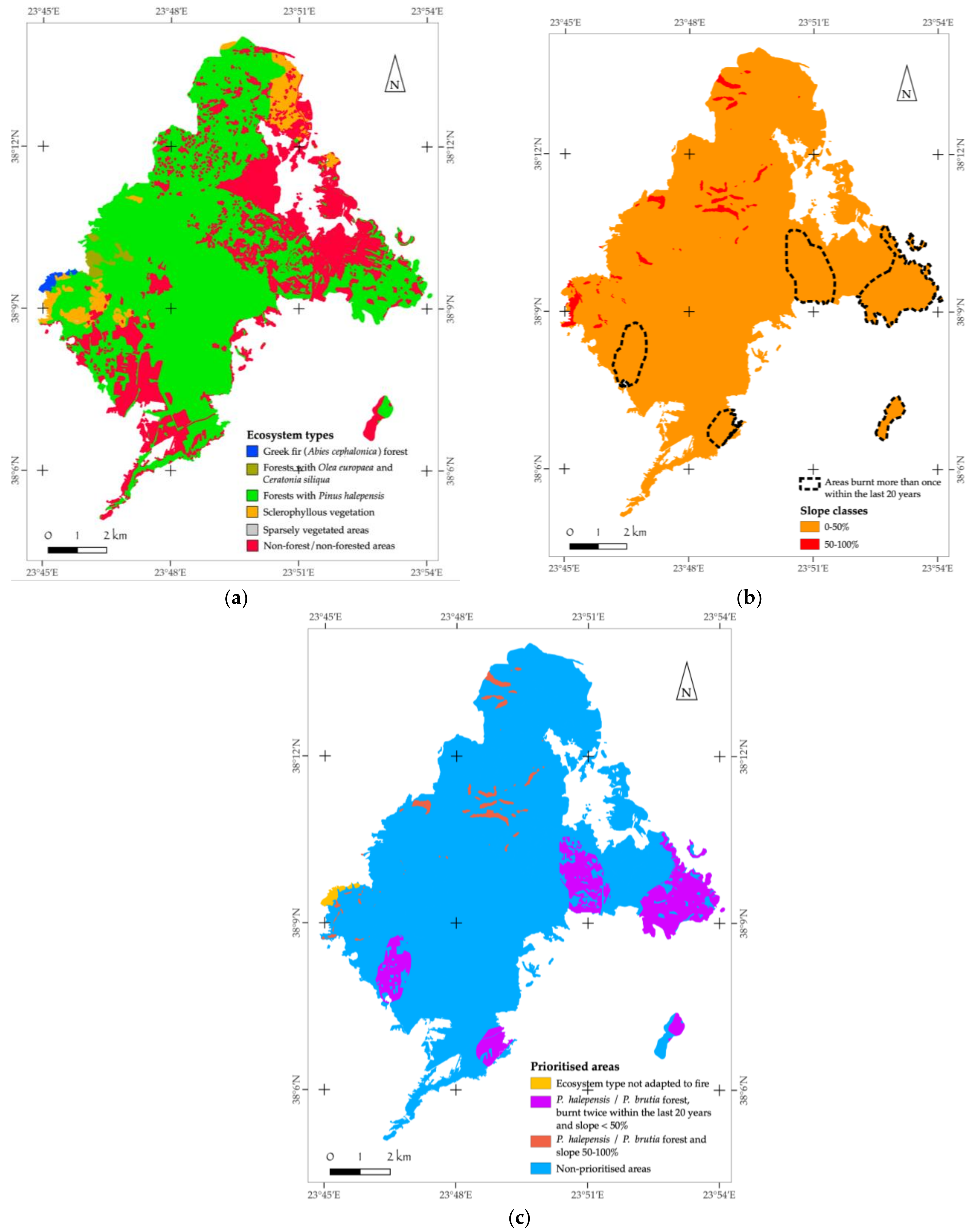
3.1. Ecosystem Type Mapping in Burnt Areas

The identification and mapping of ecosystem types (forest types, forested areas, and natural vegetation units) in the study areas resulted in the ecosystem typology presented in Table 2. Based on this typology, the relevant thematic maps (ecosystem type-based maps) were developed. A characteristic example of such a thematic map is presented in Figure 2. It is highlighted that the most affected ecosystem is the Pinus halepensis forest, with a burnt area of 25,400.5 ha in 2021 and 2613.2 ha in 2022, followed by non-forested areas and sclerophyllous vegetation. In total (for both the years 2021 and 2022), the least affected ecosystem is that with riparian vegetation, followed by forests with Juniperus spp. and sparsely vegetated areas. All other categories correspond to the intermediate affected areas. It is important to point out, however, that even the relatively small areas of burnt forests that are not adapted to fire (Abies cephalonica and Juniperus spp. forests) are considered of high importance, due to their lack of natural regeneration mechanisms.

3.2. Prioritization for Reforestation/Restoration

The application of the proposed methodology through the combination of all the aforementioned parameters led to the development of a decision tree for the identification of those areas in which reforestation/restoration should be implemented, along with their prioritization (Figure 3). In the decision tree, burnt forest ecosystems not adapted to fire are at the top of the hierarchy, among the priority areas for reforestation/restoration.
As presented in Table 3, in 2021, the total burnt surface in the 11 studied areas totaled 64,064.1 ha, of which approximately 73.8% corresponded to forests and forested areas. Of these burnt forest areas, approximately 12.5% (5905.7 ha) were identified as areas requiring reforestation/restoration. Similarly, for 2022, the total burnt surface in the 8 studied areas totaled 10,880.3 ha, of which approximately 56.4% corresponded to forests and forested areas (Table 4). Of the total burnt forest areas in 2022, approximately 42.9% (2632.0 ha) were identified as areas requiring reforestation/restoration.

3.3. Natura 2000 Network Area Loss

The assessment of the burnt areas in the Natura 2000 Network revealed that 10,618.5 ha of Natura 2000 network sites have been destroyed by fires, corresponding to 14.2% of the total burnt study areas.
It is indicative that in 14 out of the 19 fire incidents, smaller or larger parts of the Natura 2000 Network sites were burned.
In three Natura 2000 sites, i.e., GR4120008 (West Samos) and GR3000006, GR3000015 (Attica—Ano Glifada), the forest fires occurred (almost) exclusively within the limits of the Natura 2000 network area (Table 5).
The most affected Natura 2000 sites, in terms of burnt areas, were GR2530005 (Mt. Gerania) and GR3000001 (Attica—Tatoi), with 11.1% (774.3 ha) and 14.5% (2161.1 ha) of burnt areas, respectively.
The summary results of the total area burnt at each Natura 2000 site are presented in Table 5.

3.4. Restoration Measures

After the classification and prioritization of the burnt areas, the next step was the development of an ecological restoration plan, drawn up separately for each of the study areas for both years (2021 and 2022). In this context, a post-fire restoration plan was documented and detailed according to ecosystem type for all burnt natural ecosystem types. The plan describes the restoration objectives [40] and the specific measures, methods, and actions that should be carried out [13], at both the technical and institutional levels. The restoration units for each restoration plan were based on the type of ecosystem affected, taking into account the prioritization parameters set earlier. For each unit, specific actions were determined according to the characteristics of each ecosystem that was burnt, such as the forest’s adaptive capacity regarding fires (or its lack of capacity), the ‘double-burnt’ areas, those areas with steep slopes, and the ‘double-burnt’ areas with smooth and/or steep slopes. At the same time, each restoration plan should meet the objectives of the restoration, specifying the measures and actions needed to achieve them.
In general, in the case of areas that are not being prioritized for reforestation, the following measures and actions were suggested that must be implemented immediately after the fire event:
  • Prohibition of livestock grazing, because it causes the destruction of young plants and soil compaction and can significantly affect the flora composition of ecosystems [41].
  • Protection from possible land-use changes and the encroachment of burnt areas.
  • Protection from soil erosion, especially in places with high slopes where the erosion risk is higher. Accordingly, an anti-erosion protection study should be developed and implemented within a reasonable period of time before the start of the winter rains, avoiding the degradation of the regenerating plant community.
  • Protection and conservation of unburnt sites within the affected areas. The unburnt individual plant species can contribute to the natural regeneration of the area through seed dispersal [42] while, at the same time, they serve as a refuge for the remaining animals in the affected area.
All these measures focus on the gradual re-establishment of the pre-fire ecosystems that existed within the burnt areas. This should be achieved following the post-fire natural regeneration patterns, either from germinating seeds or due to the plant species’ ability to resprout without any human interventions that may hinder or delay the recovery process.
Regarding the burnt areas needing reforestation, apart from the previously discussed measures that should be applied as well, specific restoration actions were determined. One of the most important conditions that must be met in order for the restoration to be successful is the selection of appropriate tree species to be used in the reforestation program [43]. In particular, it is important that the introduction of alien species or species of Greek flora that would be outside their natural distribution should be avoided. It is very likely that the wrong species selection will disturb the natural balance between the organisms of the restored ecosystem and the surrounding areas. This may have severe consequences in many cases, e.g., the explosion of harmful insect populations, the dominance of an invasive plant species, or the disappearance of understory species from the forest ecosystem. Thus, tree species selection was based on the principle of retaining the pre-fire ecosystem type, while increasing the species mixture in order to improve the ecosystem’s resilience and increase biodiversity. Special emphasis was also given to determining the quality of the planting material according to site- and species-specific conditions [44,45]. The basic planting rules to be followed were also set, and the planting network and tree density pattern were determined.
In all cases, a successful restoration requires: the immediate and accurate mapping of all burnt areas; the immediate declaration of the affected areas as ‘reforested areas’ (in accordance with the provisions of Article 117 of the Constitution of Greece); the preservation of their forest character; their protection from grazing for at least 5 years, with a re-assessment not only for the possible extension of this time period but also protection from any land-use changes and other human interventions. In particular, the prohibition of grazing must be ensured immediately after each forest fire incident, as the young shoots and seedlings are nutrient-rich (mainly in nitrogen); therefore, they are considered excellent fodder and are particularly attractive to animals. Thus, grazing prohibition in the initial stages of post-fire succession is crucial, facilitating the natural forest regeneration and contributing to avoiding soil compaction, or erosion, which may lead to further ecosystem degradation or, even more significantly, to the ecosystem collapsing [46]. The temporal and spatial characteristics of the grazing prohibition should be able to be adjusted, depending on the respective management objectives. Thus, in some areas, the duration of prohibition may be shorter than usual; however, this is based on a dedicated management plan and close monitoring by the Forestry Service.

4. Discussion

This research presents, for the first time, a unified assessment system for areas affected by forest fires, one that prioritizes areas needing reforestation/restoration based on biotic and abiotic parameters. The main parameter, which determines not only the inclusion of a burnt area in the proposed areas for reforestation/restoration but also its prioritization among them, concerns the forest ecosystems’ lack of fire-adaptive mechanisms (i.e., its inability to achieve natural recovery/regeneration) [18,19,21]. The second parameter is the fire history of the burnt area, i.e., the fire recurrence interval [4,5]. If this interval is less than 20 years, the area is prioritized for active restoration/reforestation. The third parameter concerns the slope steepness of the relief. Finally, it highlights the finding that the majority (14 out of 19) of the fires that have occurred in the study areas affected Natura 2000-protected areas.

4.1. A Decision Support Tool for Restoration Actions

From an analysis of the results, it can be concluded that it is possible to create and implement a standardized decision-making tool for the selection of restoration/reforestation by applying a uniform method and transparent criteria in all regions in the country. The use of freely available geospatial data is sufficient to create the necessary models. However, accurately documenting the boundaries of the different vegetation units requires validation of the results using additional information from fieldwork and/or input from the local Forest Services (this work has been shown to be feasible and can be incorporated into the final product). The proposed methodology for the identification and prioritization of the areas to be reforested is a useful tool for obtaining direct information in relation to the effective use of financial and human resources for restoring the affected areas. The tool, and the methodology that it incorporates, contribute to the transparency of policymaking and management decisions with regard to restoration measures and actions. This is because the methods and the results follow specific, scientifically justifiable steps, which are easily understood by experts on the one hand and by the general public on the other hand. Furthermore, the methodology and the results are available to everyone, in order to avoid misinterpretations and doubts about the restoration options.
The proposed method for prioritizing areas and restoration options can, therefore, be an important source of information for supporting decision-making by the appropriate authorities (e.g., the Ministry of Environment and Energy, the Forest Service, and the Regions and Municipalities of Greece) and for drafting and implementing protection and restoration/reforestation studies for the burnt areas each year, aiming to ensure the sustainability of natural resources. At the same time, the results of this study provide baseline information for subsequent research and the monitoring and assessment of the affected areas. It is worth noting that the innovative methodological approach presented in this study can not only be applied in all cases of forest fires in the future but can also form the basis of a general approach regarding how to address reforestation/restoration needs in Greece.

4.2. Recommendations and Future Steps

According to the application of the suggested approach in the study areas, of the total 64,064.1 ha of burnt areas in 2021 (in the 11 studied areas), approximately 73.8% of this corresponds to forests and forested areas, while only 12.5% (5905.7 ha) was identified as areas requiring reforestation/restoration. Similarly, for 2022, the total burnt area in the 8 studied areas amounted to 10,880.3 ha, of which 56.4% corresponded to forests and forested areas, while approximately 42.9% (2632.0 ha) was identified as representing areas requiring reforestation/restoration. The notable differences between the two years are due to the differentiation of the areas and the ecosystems burnt in 2021 and 2022. These target areas for reforestation for both the studied years can be considered feasible for reforestation by the Greek Forest Service (under the current conditions), the authority responsible for forest land management. However, for the successful re-establishment of the pre-fire forest conditions and to ensure the sustainability of natural resources in the burnt areas, specific restoration/reforestation management plans should be developed based on species- and site-specific conditions [13,40]. The restoration plans should take into account the burnt ecosystem types and their distribution in the burnt area, as well as the prioritization parameters to be applied, such as the history of the burnt areas in relation to fires and the slopes of the relief. Then, necessary measures and actions, such as ensuring the quality of the planting material [44,45], the basic planting rules, the planting network to be followed, etc. [13,40], should be determined accordingly to successfully meet the restoration objectives.
Aspects of particular importance that emerged from this study and concern the spatial distribution of the restoration approach within each individual burnt area are: (i) the need to map the unaffected/unburnt sites, as well as to assess and document in situ their potential contribution to the natural restoration of the surrounding burnt areas [42]; (ii) the identification and precise mapping of the burnt areas that are part of the wildland–urban interface (WUI), which present special ecological and structural characteristics and for which a special restoration and management plan is required.
The next step of this effort is a statistical analysis of the characteristics of the areas that are prioritized or are not prioritized for reforestation/restoration, along with a correlation of the results with the entire country. The correlation is mainly necessary for those areas that have been affected by fire during the last twenty years. In this way, a first-order vulnerability assessment of those areas in the country that will probably need restoration/reforestation in the future will be achieved. An important result of this exercise will be an indication of the magnitude of the planting material that may be needed. Furthermore, such an assessment will highlight the need for the relevant financial, infrastructure, and human resources to ensure the conservation and sustainability of natural resources in these areas.
Finally, the fact that most fires affected Natura 2000 sites reinforces the need for immediate action in the protected areas and highlights the need to prioritize these areas among those sites needing restoration, in order to avoid important biodiversity losses. Adequate measures and actions to restore or improve the affected habitat types and to maintain, ameliorate, and support natural regeneration and/or artificial restoration are required. The overall goal of these efforts would be to support the local conservation target of each Natura 2000 site [47] and the provisions of the Habitats [48] and Birds Directives [49], working toward achieving the targets of the EU Biodiversity Strategy up to 2030 [50] and the recently adopted EU nature restoration legislation [51].

4.3. Assumptions and Limitations

The scale and quality of the available raw materials with regard to delineating natural vegetation units were the key limiting parameters in relation to the study’s mapping accuracy and analysis. Consequently, the production of the highly accurate spatial information required in implementation studies was limited. In this study, proposed areas to be restored, based on the available data, were identified. Although the mapping of the vegetation units was significantly improved, it was necessary to verify and confirm the locations to be restored using fieldwork. At the same time, during the application of the methodology, the following assumptions were made for the standardization of the results: (i) all areas of forest interest, as depicted in the Forest Maps of the Hellenic Cadastre, refer to natural vegetation units. (ii) The pine forests in the study areas of Samos, Rhodes, and Lesvos that were affected by fires were classified as comprising Pinus brutia, while the rest of the study areas in the mainland of Greece were classified as Pinus halepensis. (iii) The main flora species that were found in the vegetation units of each study area were retrieved mainly from the results of the composition of the relevant habitat types of the Natura 2000 network, located either within or near the areas of interest. Moreover, relevant research and studies on the respective areas, as well as information from photo interpretation and fieldwork, were used. (iv) The ‘weaknesses’ associated with the raw data that were used are acknowledged. The various data sources were developed for different purposes from each other and differ in terms of their spatial resolution (e.g., EMSR burnt-area boundaries, the MODIS algorithm for the double-burnt areas’ boundaries, and the demarcation of forest areas based on the Forest Maps of the Hellenic Cadastre).

4.4. Potential Application of the Suggested Decision-Support System in Other Ecoregions

The approaches and strategies suggested in this work rely on data concerning the conditions in Greece. However, forest fires do occur in all Mediterranean-type climate regions that present similar characteristics to Greece since, in all cases, the same Mediterranean ecosystem types are affected. It is also expected that with the current climate predictions for drier and warmer periods in the future [10,11], more intense fire incidents will occur in the Mediterranean region. As was presented above, the forest tree species in the Mediterranean ecosystems can be divided into those that have developed adaptive mechanisms to fire (either through their seeds, e.g., serotinous pines, or by vegetative regeneration) and those that have not developed post-fire adaptative and natural regeneration mechanisms (e.g., fir species, the non-serotinous pines Pinus nigra, P. silvestris, and P. pinea, and the Juniperus species). The suggested decision-support system is mainly based on the above-mentioned tree species’ mechanisms of adaptation to fire, the fire history of the area of interest, and the particular site conditions (slope inclination) that prevail in each burnt area [17]. Thus, the proposed tool, namely, a decision tree for determining and prioritizing burnt areas for reforestation/active restoration, can potentially be used in other Mediterranean-type climate regions as well.
However, the suggested strategy for the restoration/reforestation of burnt forest areas outside Mediterranean-type climate regions is not recommended because their ecosystem types greatly differ from those found in the Mediterranean region. These differences are reflected in the wide variety of responses to fires. Additionally, serotiny, which is recognized as a key adaptive trait to fire, is mainly observed in tree species in Mediterranean-type ecosystems. Thus, any similar approach for defining a restoration/reforestation strategy should be adjusted according to the tree traits and ecosystem types existing in the region in which it is applied.

5. Conclusions

The present study develops and suggests a novel approach that applies a uniform method and criteria to burnt wildlands in the Mediterranean region, to increase the level of conservation and ensure the sustainability of the natural resources of burnt areas. The approach is based on the analysis of real fire information using spatially explicit, site-specific, and ecological data for the creation and implementation of a standardized decision-making system for restoration/reforestation actions. It also suggests the use of freely available geospatial data that are considered sufficient to accurately delineate the boundaries of the affected vegetation units. Considering that the financial resources for the restoration of such burnt areas are generally limited, the proposed approach incorporates the prioritization for determining the areas to be reforested. This would make it a useful decision-making and management tool for obtaining immediate information regarding the direction and utilization of resources (i.e., financial, human) in the restoration efforts. Furthermore, with the proposed approach, misinterpretations and doubts about the restoration options would be avoided. The importance of urgent responses for burnt protected areas is highlighted, urging decision-makers and policymakers to take immediate action, following national and EU legislation, policies, and strategies. However, with regard to the global application of the suggested methodology to ecoregions outside the Mediterranean region, further research is needed.

Author Contributions

Conceptualization, methodology, formal analysis, investigation, and resources, I.T. (Iordanis Tzamtzis), P.G., I.P.K. and V.S.; resources, I.T. (Iordanis Tzamtzis), P.G., I.P.K., V.S. and D.B.; data curation, V.S., I.P.K. and I.T. (Iordanis Tzamtzis); writing—original draft preparation, I.T. (Iordanis Tzamtzis), P.G., I.P.K., V.S., D.B., M.T., I.T. (Ilias Tziritis), N.K. and N.M.G.; writing—review and editing, M.T., I.T. (Iordanis Tzamtzis), P.G., I.P.K. and D.B.; visualization, V.S. and I.P.K.; supervision, I.T. (Iordanis Tzamtzis); project administration, I.T. (Iordanis Tzamtzis). All authors have read and agreed to the published version of the manuscript.

Funding

This research was undertaken as part of the service provision agreement between WWF Greece and the company ACCEL—I. TZAMTZIS & Co G.P. and was funded by the WWF network (914/2021, 1024/2022).

Institutional Review Board Statement

Not applicable.

Informed Consent Statement

Not applicable.

Data Availability Statement

Data and maps of the studied areas are available upon request.

Acknowledgments

We are thankful to the Greek local Forest Services, which provided input data/information that helped improve the quality of the product.

Conflicts of Interest

The authors declare no conflict of interest.

References

  1. Agee, J.K. Fire Ecology of Pacific Northwest Forests; Island Press: Washington, DC, USA, 1993. [Google Scholar]
  2. Fernández-García, V.; Marcos, E.; Huerta, S.; Calvo, L. Soil-vegetation relationships in Mediterranean forests after fire. For. Ecosyst. 2021, 8, 18. [Google Scholar] [CrossRef]
  3. García-Llamas, P.; Suárez-Seoane, S.; Taboada, A.; Fernández-Manso, A.; Quintano, C.; Fernández-García, V.; Fernández-Guisuraga, J.M.; Marcos, E.; Calvo, L. Environmental drivers of fire severity in extreme fire events that affect Mediterranean pine forest ecosystems. For. Ecol. Manag. 2019, 433, 24–32. [Google Scholar] [CrossRef]
  4. Goudelis, G.; Ganatsas, P.; Tsitsoni, T.; Spanos, Y.; Daskalakou, E. Effect of two successive wildfires in Pinus halepensis stands of central Greece. Web Ecol. 2008, 8, 30–34. [Google Scholar] [CrossRef]
  5. Lioret, F.; Pausas, J.G.; Vilà, M. Responses of Mediterranean Plant Species to different fire frequencies in Garraf Natural Park (Catalonia, Spain): Field observations and modelling predictions. Plant Ecol. 2003, 167, 223–235. [Google Scholar] [CrossRef]
  6. Moghli, A.; Santana, V.M.; Baeza, M.J.; Pastor, E.; Soliveres, S. Fire Recurrence and Time Since Last Fire Interact to Determine the Supply of Multiple Ecosystem Services by Mediterranean Forests. Ecosystems 2022, 25, 1358–1370. [Google Scholar] [CrossRef]
  7. Pérez-Sánchez, J.; Jimeno-Sáez, P.; Senent-Aparicio, J.; Díaz-Palmero, J.M.; Cabezas-Cerezo, J.D. Evolution of Burned Area in Forest Fires under Climate Change Conditions in Southern Spain Using ANN. Appl. Sci. 2019, 9, 4155. [Google Scholar] [CrossRef]
  8. Singleton, M.P.; Thode, A.E.; Sánchez Meador, A.J.; Iniguez, J.M. Increasing trends in high-severity fire in the Southwestern USA from 1984 to 2015. For. Ecol. Manag. 2019, 433, 709–719. [Google Scholar] [CrossRef]
  9. WWF. The Mediterranean Burns—WWF’s Mediterranean Proposal for the Prevention of Rural Fires; WWF: Gland, Switzerland, 2019. [Google Scholar]
  10. Pausas, J.G.; Keeley, J.E. Wildfires and global change. Front. Ecol. Environ. 2021, 19, 387–395. [Google Scholar] [CrossRef]
  11. IPCC. Summary for Policy makers. In Climate Change 2023: Synthesis Report: A Report of the Intergovernmental Panel on Climate Change—Contribution of Working Groups I, II and III to the Sixth Assessment Report of the Intergov-Ernmental Panel on Climate Change; Lee, H., Romero, J., Eds.; IPCC: Geneva, Switzerland, 2023. [Google Scholar]
  12. Agbeshie, A.; Abugre, S.; Atta-Darkwa, T.; Awuah, R. A review of the effects of forest fire on soil properties. J. For. Res. 2022, 33, 1419–1441. [Google Scholar] [CrossRef]
  13. Mauri, E.; Pons, P. Handbook of Good Practices in Post-Wildfire Management: How to Mitigate or Avoid the Negative Impact of Salvage Logging in Mediterranean Forests, 2nd ed.; Universitat de Girona: Girona, Spain, 2019; p. 169. [Google Scholar]
  14. Daskalakou, E.N.; Thanos, C.A. Postfire regeneration of Aleppo pine–the temporal pattern of seedling recruitment. Plant Ecol. 2004, 171, 81–89. [Google Scholar] [CrossRef]
  15. Kazanis, D.; Arianoutsou, M. Long-term post-fire vegetation dynamics in Pinus halepensis forests of Central Greece: A functional group approach. Plant Ecol. 2004, 171, 101–121. [Google Scholar] [CrossRef]
  16. Spanos, I.; Daskalakou, E.; Thanos, C. Postfire, natural regeneration of Pinus brutia forests in Thasos island, Greece. Acta Oecologica 2000, 21, 13–20. [Google Scholar] [CrossRef]
  17. Broncano, M.J.; Retana, J.; Rodrigo, A. Predicting the Recovery of Pinus halepensis and Quercus ilex Forests after a Large Wildfire in Northeastern Spain. Plant Ecol. 2005, 180, 47–56. [Google Scholar] [CrossRef]
  18. Ganatsas, P.; Daskalakou, E.; Paitaridou, D. First results on early post-fire succession in an Abies cephalonica forest (Parnitha National Park, Greece). Iforest Biogeosci. For. 2012, 5, 6–12. [Google Scholar] [CrossRef]
  19. Espelta, J.M.; Retana, J.; Habrouk, A. An economic and ecological multi-criteria evaluation of reforestation methods to recover burned Pinus nigra forests in NE Spain. For. Ecol. Manag. 2003, 180, 185–198. [Google Scholar] [CrossRef]
  20. Tiscar, P.; Lucas-Borja, M.E.; Candel-Pérez, D. Lack of local adaptation to the establishment conditions limits assisted migration to adapt drought-prone Pinus nigra populations to climate change. For. Ecol. Manag. 2018, 409, 719–728. [Google Scholar] [CrossRef]
  21. Ioannidis, K.; Tsakaldimi, M.; Koutsovoulou, K.; Daskalakou, E.N.; Ganatsas, P. Effect of Seedling Provenance and Site Heterogeneity on Abies cephalonica Performance in a Post-Fire Environment. Sustainability 2021, 13, 6097. [Google Scholar] [CrossRef]
  22. Underwood, E.C.; Hollander, A.D.; Molinari, N.A.; Larios, L.; Safford, H.D. Identifying priorities for post-fire restoration in California chaparral shrublands. Restor. Ecol. 2022, 30, e13513. [Google Scholar] [CrossRef]
  23. Alloza, J.A.; Vallejo, R. Restoration of Burned Areas in Forest Management Plans; Kepner, W.G., Ed.; Desertification in the Mediterranean Region: A Security Issue; Springer: Dordrecht, The Netherlands, 2006. [Google Scholar]
  24. Alloza, J.A.; Baeza, M.J.; De la Riva, J.; Duguy, B.; Echeverra, M.T.; Ibarra, P.; Llovet, J.; Prez-Cabello, F.; Rovira, P.; Vallejo, V.R. A model to evaluate the ecological vulnerability to forest fires in Mediterranean ecosystems. For. Ecol. Manag. 2006, 234, S203. [Google Scholar] [CrossRef]
  25. Copernicus Emergency Management Service—Mapping (CEMSM). Available online: https://emergency.copernicus.eu/mapping/copernicus-emergency-management-service#zoom=2&lat=27.6533&lon=-25.0083&layers=0BT00 (accessed on 10 December 2022).
  26. European Forest Fire Information System (EFFIS). Available online: https://effis.jrc.ec.europa.eu/ (accessed on 10 December 2022).
  27. Global Wildfire Information System (GWIS). Available online: https://gwis.jrc.ec.europa.eu/apps/country.profile/downloads (accessed on 10 December 2022).
  28. Hellenic Cadastre. Electronic Services, Forest Map Suspension; Hellenic Cadastre: Cholargos, Greece, 2022. [Google Scholar]
  29. Copernicus Land Monitoring Service (CLC). Available online: https://land.copernicus.eu/pan-european/corine-land-cover/clc2018?tab=download (accessed on 10 December 2022).
  30. Hellenic Cadastre. Electronic Services, Orthophotographs Viewer. Available online: https://www.ktimanet.gr/CitizenWebApp/Orthophotographs_Page.aspx (accessed on 10 December 2022).
  31. Google Earth. Available online: https://earth.google.com/web/ (accessed on 6 January 2023).
  32. IGME—Institute of Geology and Mineral Exploration. Geological Map of Greece, Scale 1:500,000; IGME: Athens, Greece, 1983. [Google Scholar]
  33. European Environment Agency, Copernicus Land Monitoring Service, European Digital Elevation Model (EU-DEM). Available online: https://land.copernicus.eu/imagery-in-situ/eu-dem/eu-dem-v1.1/view (accessed on 10 December 2022).
  34. Ministry of Agriculture. Forest Map of Greece (Scale 1:500,000); Forest Service, Directorate of Forest Mapping: Athens, Greece, 1992. [Google Scholar]
  35. Ministry of Environment and Energy. Development of Large Scale (1:5000) Spatial Data Infrastructure for Terrestrial Areas Protected under the «Νatura 2000» Network at a National Scale. 2016. Available online: http://mapsportal.ypen.gr/layers/geonode:habitats_egsa87 (accessed on 10 November 2022).
  36. Hellenic National Meteorological Service. Climatology (HNMS). Available online: http://www.emy.gr/emy/en/climatology/climatology (accessed on 10 November 2022).
  37. QGIS. QGIS Geographic Information System: Open Source Geospatial Foundation Project. 2021. Available online: http://qgis.org (accessed on 10 December 2022).
  38. Arianoutsou-Faraggitaki, Μ.; Margaris, N.S. Decomposers and the Fire Cycle in a Phryganic (East Mediterranean) Ecosystem. Microb. Ecol. 1982, 8, 91–98. [Google Scholar] [CrossRef] [PubMed]
  39. Ganatsas, P.; Giannakaki, M.; Gouvas, A.; Tsakaldimi, M. Is the Reproduction Capacity of Pinus brutia Stands 20 Years after Wildfire Efficient to Secure Forest Restoration in the Case of a Fire Re-Occurrence? Forests 2021, 12, 991. [Google Scholar] [CrossRef]
  40. Stanturf, J.; Palik, B.; Dumroese, R.K. Contemporary forest restoration: A review emphasizing function. For. Ecol. Manag. 2014, 331, 292–323. [Google Scholar] [CrossRef]
  41. Dafis, S. Forest Ecology; Giahoudi-Giapouli: Thessaloniki, Greece, 1986. [Google Scholar]
  42. Christopoulou, A.; Fyllas, N.M.; Andriopoulos, P.; Koutsias, N.; Dimitrakopoulos, P.G.; Arianoutsou, M. Post-fire regeneration patterns of Pinus nigra in a recently burned area in Mount Taygetos, Southern Greece: The role of unburned forest patches. For. Ecol. Manag. 2014, 327, 148–156. [Google Scholar] [CrossRef]
  43. Chatzistathis, A.; Dafis, S. Reforestation—Forest Nurseries; Giahoudi-Giapouli: Thessaloniki, Greece, 1989. [Google Scholar]
  44. Marsh, C.; Crockett, J.L.; Krofcheck, D.; Keyser, A.; Allen, C.D.; Litvak, M.; Hurteau, M.D. Planted seedling survival in a post-wildfire landscape: From experimental planting to predictive probabilistic surfaces. For. Ecol. Manag. 2022, 525, 120524. [Google Scholar] [CrossRef]
  45. Mataruga, M.; Cvjetković, B.; De Cuyper, B.; Aneva, I.; Zhelev, P.; Cudlín, P.; Metslaid, M.; Kankaanhuhta, V.; Collet, C.; Annighöfer, P.; et al. Monitoring and Control of Forest Seedling Quality in Europe. For. Ecol. Manag. 2023, 546, 121308. [Google Scholar] [CrossRef]
  46. Zagas, T.; Ganatsas, P.; Tsitsoni, T.; Tsakaldimi, M. Post-fire regeneration of Pinus halepensis Mill. stands in the Sithonia peninsula, northern Greece. Plant Ecol. 2004, 171, 91–99. [Google Scholar] [CrossRef]
  47. Ministry of Environment and Energy. Setting Conservation Objectives for Natural Habitat Types of Annex I and of Species of Annex II of the Directive 92/43/EEC in Special Areas of Conservation and Sites of Community Importance of the National Ecological Network NATURA 2000; Hellenic Government Gazette 1807 B; Ministry of Environment and Energy: Athens, Greece, 2023. [Google Scholar]
  48. Council of the European Communities. Council Directive 92/43/EEC of 21 May 1992 on the conservation of natural habitats and of wild fauna and flora. Off. J. Eur. Communities 1992, 6, 7–50. [Google Scholar]
  49. Council of the European Communities. Council Directive 2009/147/EEC of 30 November 2009 on the conservation of wild birds. Off. J. Eur. Communities 2009, 20, 7–25. [Google Scholar]
  50. European Commission. EU Biodiversity Strategy for 2030: Bringing Nature Back into Our Lives; European Commission: Brussels, Belgium, 2020. [Google Scholar]
  51. European Commission Directorate-General for Environment. Nature Restoration Law—For People, Climate, and Planet; Pub-lications Office of the European Union. 2022. Available online: https://op.europa.eu/en/publication-detail/-/publication/a0e3cfac-f600-11ec-b976-01aa75ed71a1/language-en (accessed on 10 December 2022).
Figure 1. Map of Greece depicting the location of the fire-related incidents under study (study areas): (1) Kefalonia, (2) Portes Achaia, (3) Ileia—Arkadia, (4) Krestena, (5) Messinia—Arkadia, (6) East Mani, (7) Fokida, (8) Itea, (9) Mt. Gerania, (10) Mt. Pateras—Vilion, (11) Attica—Tatoi, (12) Mt. Penteli, (13) Attica—Ano Glifada, (14) Lavreotiki, (15) Lesvos (Vrisa—Vatera), (16) Samos, (17) West Samos, (18) Rhodes, and (19) Rethimno.
Sustainability 15 15986 g001
Figure 2. Indicative outcomes of study results for the Attica–Tatoi study area: (a) map according to ecosystem type; (b) areas burnt more than once within the last 20 years, shown on a slope classes map; (c) prioritization map of areas for reforestation/restoration.
Sustainability 15 15986 g002
Figure 3. Decision tree for determining and prioritizing the proposed areas for reforestation/restoration.
Sustainability 15 15986 g003
Table 1. Study areas and fire incident date.
Year 2021Year 2022
Study AreaDate of FireStudy AreaDate of Fire
Mt. Gerania 19 May 2021Attica—Ano Glifada4 June 2022
Kefalonia 3 July 2021Portes Achaia3 July 2022
Samos 15 July 2021Itea4 July 2022
Rhodes 1 August 2021West Samos13 July 2022
Attica—Tatoi 3 August 2021Rethimno15 July 2022
East Mani 3 August 2021Mt. Penteli20 July 2022
Messinia—Arkadia 4 August 2021Lesvos (Vrisa—Vatera)23 July 2022
Ileia—Arkadia4 August 2021Krestena24 July 2022
Fokida 5 August 2021
Mt. Pateras—Vilion 16 August 2021
Lavreotiki 16 August 2021
Table 2. Categories and types of ecosystems identified in the study areas.
CategoryTypeBurnt Area (ha)
2021/2022
Mountain temperate coniferous forests Forests with Abies cephalonica573.2/n.a.
Mediterranean coniferous forests Forests with Pinus halepensis25,400.5/2613.2
Mediterranean coniferous forests Forests with Pinus brutia1098.9/1894.8
Mediterranean coniferous forests Forests with Juniperus spp. n.a./85.8
Mediterranean sclerophyllous forests Forests with Olea europaea and Ceratonia siliqua124.0/184.8
Mediterranean sclerophyllous forests Forests with Quercus ilex706.1/n.a.
Mediterranean sclerophyllous forests Forests with Quercus coccifera684.4/n.a.
Mediterranean deciduous forests Thermophilous oak forests with Quercus pubescens and Quercus frainetto2893.7/n.a.
Riparian vegetation Riparian vegetation (e.g., forests with Platanus orientalis, Salix alba, and Populus alba) 44.8/15.7
Sclerophyllous vegetation Sclerophyllous vegetation (shrublands of evergreen broadleaf) 14,825.4/716.1
Heathland and shrubs Phrygana 597.2/324.6
Grassland Pasture 279.0/277.8
Sparsely vegetated areas Sparsely vegetated areas 81.5/25.2
Non-forested areas Non-forested areas 16,755.3/4742.3
Note: n.a. = not applicable.
Table 3. Summary results of the burnt areas and those areas identified and prioritized for reforestation/restoration in 2021.
Study AreaBurnt AreaAreas that Have Been Identified and Prioritized for Reforestation
Species Not Adapted to FireAreas with Pinus halepensis/Pinus brutia
Total AreaForest AreaDouble-Burnt and Slopes of 50–100%Double-Burnt and Slopes of <50%Slopes of
50–100%
(ha)
Mt. Gerania 6646.65890.537.7-54.4610.0
Kefalonia 600.8417.1----
Samos 359.1319.3-39.7179.90.6
Rhodes 1155.51056.1---13.8
Attica—Tatoi 8371.76367.628.3-813.2112.6
Messinia—Arcadia 5104.23815.1----
East Mani 10,425.96813.8507.2-56.34.9
Ileia—Arkadia 18,261.610,435.8-161.12644.1331.8
Fokida 2825.92385.0----
Mt. Pateras—Vilion 9756.99419.8-3.756.3173.6
Lavreotiki 555.9388.6--76.5-
Total 64,064.147,308.7573.2204.53880.71247.3
Percentage of the total area 73.8%0.9%0.3%6.1%1.9%
Table 4. Summary results of the burnt areas and those areas identified and prioritized for reforestation/restoration in 2022.
Study AreaBurnt AreaAreas that Have Been Identified and Prioritized for Reforestation
Species Not Adapted to FireAreas with Pinus halepensis/Pinus brutia
Total AreaForest AreaDouble-Burnt and Slopes of 50–100%Double-Burnt and Slopes of <50%Slopes of
50–100%
(ha)
Mt. Penteli 2772.51598.1-90.91468.51.0
Lesvos (Vrisa—Vatera)2449.31672.3-1.114.9254.0
Rethimno2019.6439.6----
Itea1215.5815.185.8---
Portes Achaia826.2573.6-130.1264.030.5
Krestena732.0304.8-32.186.261.7
Attica—Ano Glifada431.5420.5-0.61.118.6
West Samos433.7314.0---90.9
Total 10,880.36138.085.8254.81834.7456.7
Percentage of the total area 56.4%0.8%2.3%16.9%4.2%
Table 5. Summary results of the burnt areas in the Natura 2000 network. SCI: Sites of community importance; SPA: special protected areas.
Study AreaTotal Area of Fire in the Study AreaNatura 2000 Site
CodeTypeTotal Area (ha)Burnt Area (ha)Share of Fire Area inside Natura 2000 Site (%)Share of Natura 2000 Site Burnt
(%)
East Mani10,425.9GR2540003SCI10,628.02.10.0 10.0 1
Itea1215.5GR2450004SCI10,604.310.70.90.1
Rhodes1155.5GR4210006SCI11,312.454.44.70.5
Samos359.1GR4120002SCI4896.669.019.21.4
Lavreotiki555.9GR3000005SCI5382.3228.141.04.2
East Mani10,425.9GR2550006SCI53,688.52417.123.24.5
Fokida2825.9GR2450004SCI10,604.3491.617.44.6
West Samos433.7GR4120008SPA9117.8433.099.84.7
Attica—Ano Glifada431.5GR3000006SCI8812.8431.5100.04.9
East Mani10,425.9GR2550009SPA48,817.12417.123.24.9
Attica—Ano Glifada431.5GR3000015SPA8304.9431.5100.05.2
Itea1215.5GR2450009SPA12,207.4697.257.45.7
Mt. Gerania6646.6GR2530005SCI6987.0774.311.611.1
Attica—Tatoi8371.7GR3000001SCI/SPA14,921.82161.125.814.5
Total54,920.0 216,285.310,618.5
1 The exact value is 0.02%.
Disclaimer/Publisher’s Note: The statements, opinions and data contained in all publications are solely those of the individual author(s) and contributor(s) and not of MDPI and/or the editor(s). MDPI and/or the editor(s) disclaim responsibility for any injury to people or property resulting from any ideas, methods, instructions or products referred to in the content.

