Article

Spatiotemporal Evolution and Driving Factors of Land Development: Evidence from Shandong Province, China

1
School of Economics, Shandong University of Finance and Economics, Jinan 250014, China
2
School of Business, Shandong Normal University, Jinan 250358, China
3
Faculty of Economics, Chiang Mai University, Chiang Mai 50200, Thailand
*
Author to whom correspondence should be addressed.
Sustainability 2023, 15(20), 15069; https://doi.org/10.3390/su152015069
Submission received: 20 July 2023 / Revised: 10 October 2023 / Accepted: 17 October 2023 / Published: 19 October 2023
(This article belongs to the Special Issue Spatial Analysis for the Sustainable City)

Abstract

:
As populations and economies have grown rapidly, questions of land development and use have intensified. It has become a major global concern to achieve sustainable land use practices. This study reveals evolution of the spatiotemporal pattern of land development intensity of counties in Shandong Province by introducing a land development intensity measurement model combined with three-dimensional trend surface and spatial autocorrelation analyses. Geodetector and geographically weighted regression models were employed to demonstrate the interplay and spatiotemporal heterogeneity between development intensity and drivers. The empirical results show that the value of land development intensity of counties in Shandong Province shows a general growth trend, with the number of counties with higher values gradually increasing and the number of counties with lower values gradually decreasing. We also found that the spatial heterogeneity of land development intensity across counties in Shandong Province is significant, and the spatial distribution pattern is basically consistent with the “one group, two centers and three circles” strategy proposed by the Shandong Provincial Government. There is also a positive spatial correlation and clustering effect of land development intensity of counties in Shandong Province. High (low) value clusters are concentrated in core hot (cold) counties, driving some of the surrounding counties towards radial development. The alteration in the intensity of county land development is a complex occurrence that is shaped by numerous factors. Among these, GDP per capita and population density have the primary influence on land development of counties in Shandong Province. To achieve coordinated regional social, economic, and environmental benefits, land development within the county should adhere to the principle of adapting to local conditions and implement differentiated development strategies according to different development intensities.

1. Introduction

Land development, which is of great importance for the development of human urbanization, is a comprehensive activity to bring unused land into a usable state by means of engineering, biological, or integrated measures [1,2,3]. In recent years, there has been an acceleration in China’s urbanization process and a sharp increase in the demand for land for development [4]. According to the primary data report of the Third National Land Survey, China’s total land area has increased by 22.3% since the previous survey, and intensive urbanization has led to an increase in the conflict of interest between land supply and demand [5,6,7,8,9]. At the end of 2021, the urban population of China had reached a proportion of 64.71%. However, the total amount of development land in established towns and cities was 52.81% less than the land available in villages. This shortage did not fulfill the demand for development land, and the distribution of land per capita was found to be highly uneven [10,11]. Amidst this challenging situation, efficient distribution of land resources has emerged as a crucial approach to achieving sustainable land development [12].
Scholarly studies on land development concentrate on land use [13,14], land consolidation [15,16], land development management [17,18], and land development models [19,20]. Chu [21] investigated the changes in land use and cover in the Guangdong–Hong Kong–Macao Greater Bay Area (GHMA) using the transfer matrix method. It was discovered that socio-economic factors strongly influence the alteration of land use patterns in the study area. Zhou [22] clearly defined land consolidation and discussed its internal logic and implementation process for rural renewal. Valtonen [23] conducted a comparative case study on risk management in public land development projects in Finland and the Netherlands. O’Brien [24] examined the effects of three land development models, highlighting the significance of institutional analysis. The results yielded references to optimize land resource allocation, yet there remains a dearth of studies examining the intensive land use viewpoint. Land development intensity is a comprehensive indicator of the degree of land development and utilization resulting from intensive land use [25]. The investigation into land development intensity can enhance coordination of land development and urbanization, improve the allocation of land resources, and establish a scientific foundation for regional territorial spatial planning [26,27]. Currently, research by scholars into land development intensity primarily centers around three main areas: regional disparities in land development intensity [28], spatial and temporal progression of land development intensity [29], and the influences that drive land development intensity [30]. Li and Li [31,32] conducted quantitative analyses of changes in cropland usage intensity in the study area by examining Shandong Province and Heilongjiang Province. Zhang [33] utilized spatial autocorrelation, standard deviation ellipse, and geographically weighted regression techniques to evaluate spatial patterns and heterogeneity regarding the level of land development for construction purposes. This was demonstrated using prefecture-level cities as an example and revealed that different regions in China differ in their influential factors on the level of land development intensity. Using ordinary least squares and geographically weighted regression methods, Xin [25] concluded that investment intensity and the natural environment are the primary determinants of land development intensity in western China. Other schools employing remote sensing and GIS techniques [34] or the Spatial Dubin Model [35], spatial autocorrelation [36], and the three-dimensional trend surface [28] have established a close relationship between the intensity of land development and factors such as population [37], economy [38], industrial structure [39], policy [40], and transport [41].
In summary, previous research has predominantly focused on administrative regions, including countries, provinces, and prefectural cities. A standard practice has been to employ the ratio of the construction land area to the total area of the region as a measure of land development intensity [25]. Additionally, a single model was used to identify factors affecting land development intensity. The academic contribution of this study is reflected in the following: Firstly, in terms of the study area, the study of land development intensity is carried out around the county. Counties are geographic administrative areas with a long-standing history, clearly defined boundaries, and self-sufficient systems. They are essential for spatial planning and urban development [39]. Governments usually put in place zones and mechanisms for land use and development within counties to achieve resource allocation efficiency [42,43]. Secondly, in the selection of land development intensity measurement models, we introduced a land development intensity measurement model to comprehensively measure land, population, and economic indicators to comprehensively reflect the value of land development intensity. Thirdly, the identification of causal factors involves the integration of Geodetectors and geographically weighted regression models. The use of both methods served to eliminate multicollinearity [44], leading to a more precise identification and ranking of influencing factors. Additionally, it provided a spatial visualization of the direction and degree of these factors [45,46]. Furthermore, it enabled the analysis of the interplay between driving factors and the investigation of spatial and temporal heterogeneity.
Based on this, this study investigates the spatiotemporal pattern of land development intensity in 136 counties in Shandong Province by utilizing a land development intensity measurement model in combination with three-dimensional trend surface and spatial autocorrelation analyses. Furthermore, the connection between the intensity of development and driving force is elucidated by means of Geodetector and geographically weighted regression models. It is intended that this study will provide a scientific reference for optimizing the allocation of land development resources and building a land system for high-quality development.

2. Data

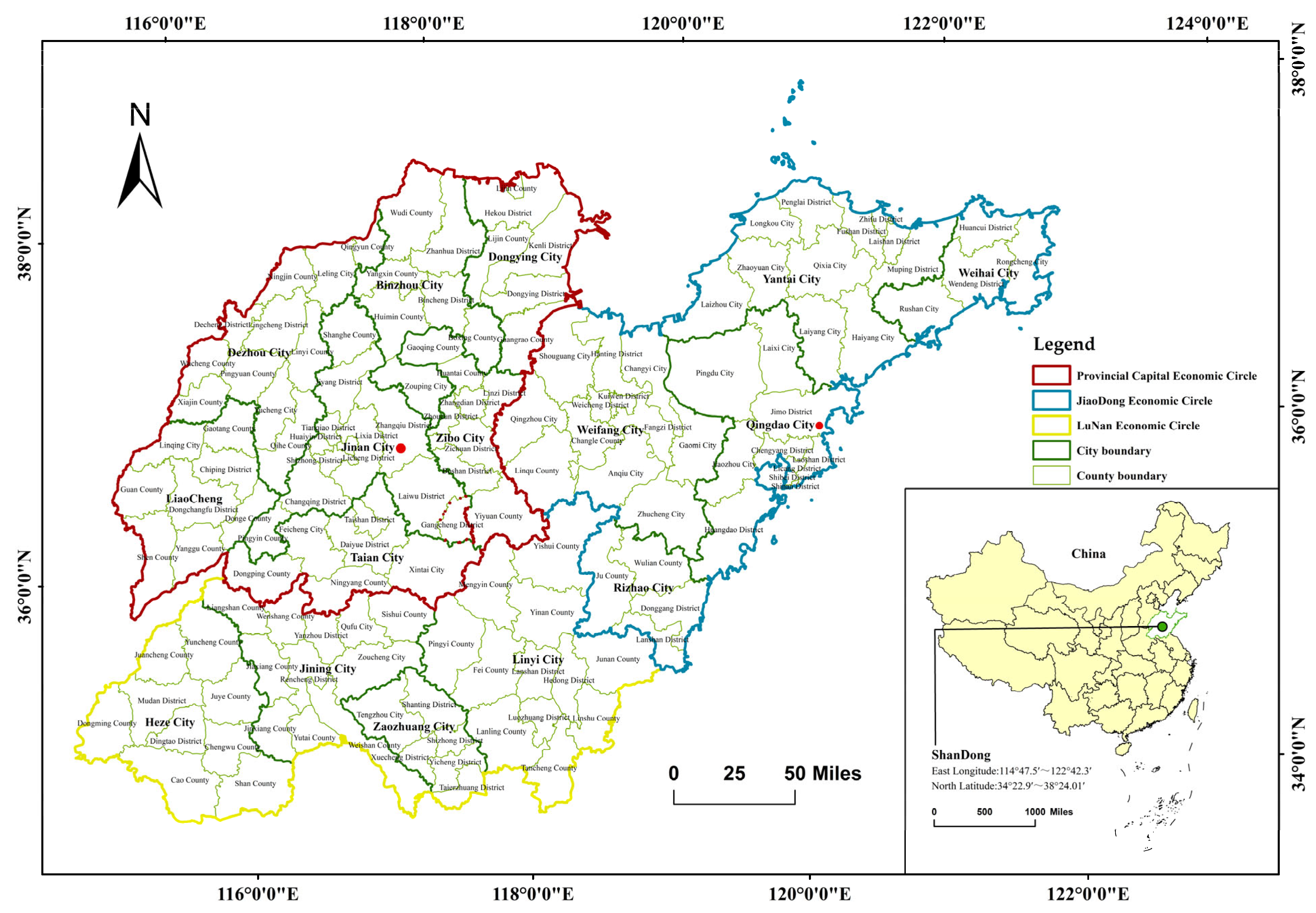
2.1. Overview of the Study Area
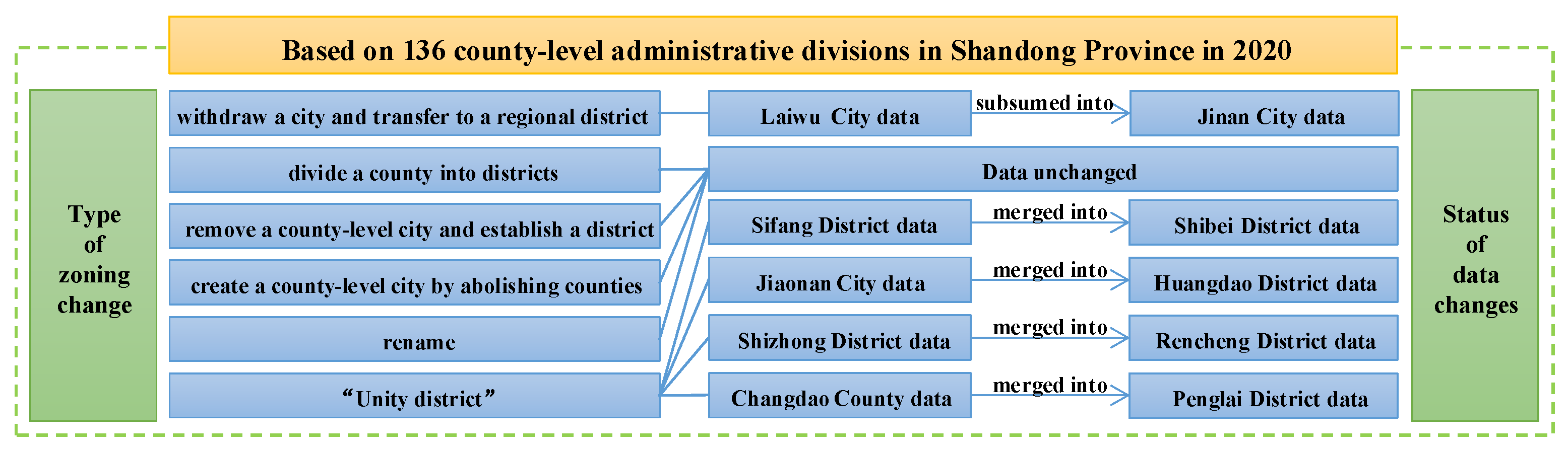
Shandong Province has a land area of 157,965 km2 and a land development area of 29,194 km2, as well as 136 county-level administrative divisions (Figure 1) and a total year-end population of 101.65 million people in 2020. Shandong Province is fourth in the country in terms of the number of county-level administrative divisions and second in the country in urban land development, making it a typical representative of county-level land development and one of the most economically developed provinces in China [47]. In 2020, the Implementation Programme for Implementing the Opinions of the <Committee of the Central Committee of the Communist Party of China and the State Council on the Establishment of a New Mechanism for More Effective Regional Coordinated Development> in Shandong Province proposed building a regional development pattern of “one group, two centres and three circles”. “One group” relates to the construction of a city cluster with a global impact on the Shandong Peninsula. Additionally, “two centers” will support Jinan and Qingdao in their quest to become national central cities. Finally, the “three circles” initiative is aimed at promoting the integrated regional development of the three economic circles of the provincial capital, Jiaodong and Lunan. Currently, Shandong Province is in a crucial phase of economic transformation and industrial upgrading. However, there are significant issues, including disproportionate county development and substantial disparities in land development and utilization indicators. These obstacles impede the province’s growth, highlighting the pressing need for research into the extent of county land development.
To ensure the study unit’s consistency, adjustments were made to the data for the relevant years and counties with reference to zoning changes between 2005 and 2020. This paper uses 136 county-level administrative divisions (comprising 58 city districts, 26 county-level cities, and 52 counties) situated in Shandong Province in 2020 as a standard to ensure consistency in the boundaries of the study units during the study period in order to conduct comparative analyses of the data (Figure 2). A note of clarification is needed:
(1)
In 2019, Laiwu City withdrew from the central area and established its own districts, ultimately merging with Jinan City. Therefore, all data within the scope of the former Laiwu City during the study period have been categorized under Jinan City.
(2)
The study units for dividing a county into districts, removing a county-level city and establishing a district, and creating a county-level city by abolishing counties were mostly constant throughout the study period.
(3)
The module on the counties renamed during the study period remains unchanged.
(4)
Two counties were amalgamated into a new county. Due to a significant alteration in the study unit, data from the two previous counties were amalgamated into the new county’s dataset for the study period.

2.2. Sources of Data

The degree of land development in a county is subject to variability influenced by demographic, economic, social, natural, and miscellaneous factors [37,48]. Population growth leads to increased demand for land development [49]. Economic development offers financial stability for land development, whereby GDP per capita, financial investment, and imports and exports play significant roles in determining land development outcomes [50,51]. The proportion of secondary and tertiary industries has an impact on the demand and structure of land development [52]. Furthermore, alterations in land development intensity can be supported by both topography and natural resources [25,48]. Based on the principle of data accessibility, this study combines previous research [35,37,38,39,40,53,54,55,56,57] on the current land development in counties located in Shandong Province. Thirteen indicators have been selected as independent variables covering eight levels of socio-economic development, population agglomeration, residents’ financial capability, terrain conditions, investment intensity, openness, industrial structure quality, and natural resource conditions.
This research uses four instances of land use data obtained from the Centre for Resource and Environmental Science and Data of the Chinese Academy of Sciences spanning the years 2005, 2010, 2015, and 2020. Raw data for local government districts were acquired from the National Geographic Information Resources Catalogue Service (https://www.webmap.cn, accessed on 2 July 2022). The Digital Elevation Model (DEM) was obtained from the Geospatial Data Cloud (http://www.gscloud.cn, accessed on 1 August 2022). Socio-economic data were sourced from the China County Statistical Yearbook, Shandong Statistical Yearbook, Shandong Yearbook, statistical yearbooks of each city, and the official website of the Bureau of Statistics for the period 2005–2021 (Table 1).

2.3. Research Methods

2.3.1. Land Development Intensity Measurement Model

The degree of land development is intricately connected to land availability, population size, and economic factors. It provides a comprehensive representation of the land proportion earmarked for development, population density, and land productivity. The calculation formula is as follows [58,59,60]:
LDI = α DLA TA + β RP DLA + γ OV DLA
wherein LDI refers to land development intensity, while DLA, TA, PR, and OV respectively refer to development land area, total area, regional population, and output value. DLA/TA denotes the proportion of land designated for development, while RP/DLA refers to the density of population that the said land can support and OV/DLA signifies the strength of output produced by the land. α, β, and γ denote the weights assigned to development land share, population carrying density, and land output strength, respectively, as positive indicators. The data sources are presented in Table 1.
Firstly, the raw data were positively standardized using Excel 2016 64-Bit Edition to eliminate the effect of dimension and ensure the comparability of the data. The formula is as follows [61]:
X i j = X i j X j min X j max X j min ( Positive   indicator )
where X i j is the original value; X i j is the standardized value; and X j max and X j min represent the maximum and minimum values of the ith indicator in the study period, respectively. The weight values of the entropy value method were calculated using Excel 2016 64-Bit Edition, resulting in α, β, and γ values of 0.30, 0.12, and 0.58, respectively. The formula is as follows [26,62,63]:
P i j = X i j i = 1 n X i j
H j = 1 ln n i = 1 n P i j ln P i j
W j = 1 H j j = 1 m ( 1 H j )
where P i j is the weight of the jth indicator in the ith year; H j and W j are the entropy value and weight of the indicator, respectively; and n and m are the number of samples and indicators, respectively. Finally, the LDI values were calculated using Excel software, providing a comprehensive measure of land development intensity in the study area. A higher LDI value indicates a greater intensity of land development, while a lower value indicates the opposite.

2.3.2. Analysis of Three-Dimensional Trend Surface

Analysis of the three-dimensional trend surface is a multi-view 3D perspective view based on a spatial dataset. It adopts a mathematical surface to simulate the spatial distribution and the variation pattern in geographic system elements. The visual surfaces are constructed through points and lines with a certain attribute as height using ArcMap 10.8 software, revealing the overall distribution pattern of the spatial arrangement. The green dot specified in the diagram represents the sample point, and the blue and dark green points correspond to the projections of the green dot on YZ and XZ planes, respectively. The light green and blue curves represent the distribution trends of the sample in the east–west and north–south directions [28].

2.3.3. Analysis of Spatial Autocorrelation

To further expose the spatial distribution of land development intensity of counties in Shandong Province, this study utilizes ArcGIS 10.8 software to conduct global and local autocorrelation analyses of the research region. Firstly, this study introduces Moran’s I index to analyze the global autocorrelation of land development intensity between research units. The calculation formula is as follows [64,65]:
I = N i = 1   N j = 1   N W i j × i = 1   N j = 1   N W i j ( X i X ¯ ) ( X j X ¯ ) i = 1   N ( X i X ¯ ) 2
wherein I is Moran’s I index value, X i and X j are the observed values of land development intensity in regions i and j, respectively, and W i j is the spatial weight matrix, where the value range of Moran’s I index is [−1, 1]. When Moran’s I is less than, equal to, or greater than 0, it respectively indicates that the global space study units are negative correlated, uncorrelated, or positively correlated [36]. The closer it is to 1, the stronger the spatial aggregation; otherwise, it is more discrete.
The Getis–Ord G i * index is utilized to examine the local autocorrelation of land development intensity among county study units in Shandong Province and to identify the spatial distribution of high-value clusters (hot spots) and low-value clusters (cold spots) of study units. The calculation formula is as follows [66]:
G i * d = i = 1 n w i j d x j j = 1 n x j
wherein d is the distance scale, w i j d is the spatial weight between spatial units i and j, xi is the observed value of region j, and n is the quantity for the region. For purposes of explanation, G i * d is standardized to obtain a Z-score. Areas with high Z scores and small p-values indicate a hot spot of greater intensity of land development, while those with low and negative Z scores and small p-values represent a cold spot intensity of land development [33].

2.3.4. Geodetector and Geographically Weighted Regression Models

In this study, a combination of Geodetector and geographically weighted regression models [67,68] was employed to uncover the connection between development intensity and drivers. Geodetector is a statistical technique that identifies spatial heterogeneity in geographical elements and determines their driving factors by utilizing four modules: a factor detector for reviewing the explanatory capacity of factors; an interaction detector for assessing the explanatory capacity of factors following two-by-two interactions; an ecological detector for evaluating if there is any significant difference in the impact of the factors on spatial distribution; and a risk detector for examining if there is any significant variation in the attribute mean values between the regions of the two identified factors [39,69]. Due to the high number of primary selected factors, a factor detector and an interaction detector module were introduced to screen the factors with the strongest explanatory power and examine the impact of the driving forces and their interaction effects on land development intensity in Shandong Province counties. This approach aims to avoid the influence of multicollinearity and ensure a clear analysis of the most significant factors.
To investigate the spatial variations in the influential factors, a geographically weighted regression model was introduced using ArcGIS software. The model effectively reflects the differentiation of parameters across the spatial domain. The model is structured as follows [70]:
y i = α 0 u i , v i + k = 1 , m α k u i , v i x i k + ε i
wherein yi refers to land development intensity of the ith county region unit, (ui, vi) is the coordinate of this county region unit, α k (ui, vi) is the value of the continuous function α k u , v in this county region unit, xik is its kth explanatory variable, and ε i is a random error.

3. Results

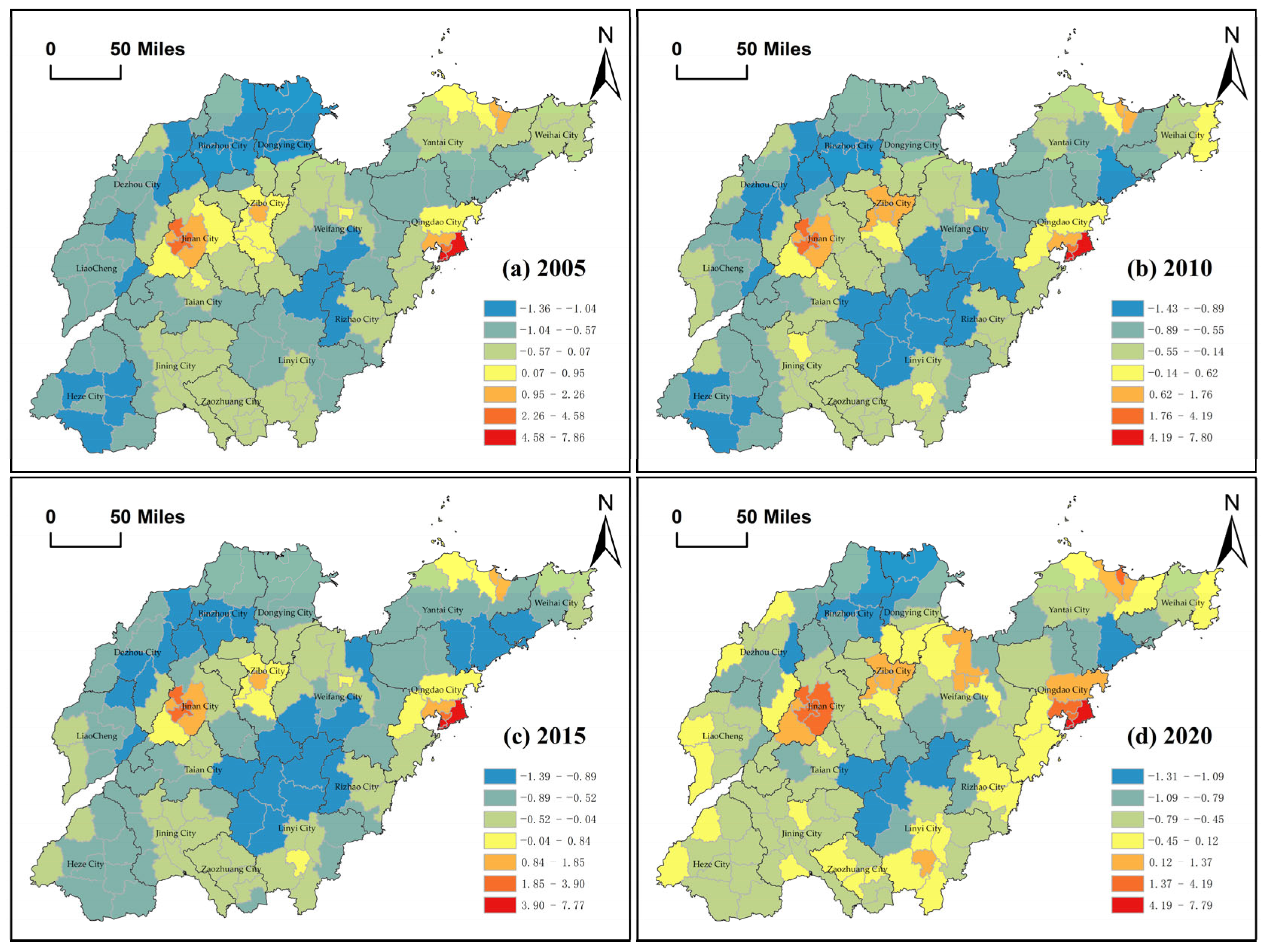
3.1. Pattern Evolution of Land Development Intensity

3.1.1. Overall Pattern Variation

From the perspective of temporal changes in land development intensity in the counties of Shandong Province (Figure 3), land development in these counties exhibited an overall increasing trend from 2005 to 2020. However, the rate of chain growth decelerated. The mean intensity of land development in the counties of the province increased from 0.103 in the year 2005 to 0.112 by the year 2020, generating an average annual growth rate of 0.56% and an increase of 8.74%. From 2005 to 2015, the average value of land development intensity in Shandong Province’s counties continuously increased from 0.103 to 0.114, with an average annual growth rate of 1.02%. Additionally, 72.79% of counties exhibited development intensity levels greater than their 2005 values. Since 2015, the average county land development intensity in Shandong Province has shown a marginal descent from 0.114 to 0.112 in 2020, equating to a reduction of 1.75%. Additionally, only 30.15% of counties exhibited an increase in development intensity values.
From the alterations in the spatial distribution of land development intensity of counties in Shandong Province (Figure 4), it is evident that the values of land development intensity among 136 counties from 2005 to 2020 are significantly varied, with considerable spatial heterogeneity. Land development intensity is generally low across all counties, with only 34 counties exceeding the average value and a total of 102 counties remaining at a low level of development intensity. The locality displaying the maximum mean value for development intensity is Shinan District in Qingdao, while Kenli District in Dongying depicts the minimum mean value. The difference between the two is 0.85, which is more than 99.26% of the county’s average development intensity. Specifically, in 2005, the high level of development intensity counties for Qingdao Shinan District, Shibei District, Jinan Lixia District, the three counties of Jinan Shizhong District, Huaiyin District, and Zibo Zhangdian District, and 28 other counties are relatively high-, medium-, or low-level counties. There are up to 105 counties exhibiting low levels of development intensity. In both 2010 and 2015, Qingdao Shinan District exhibited a high level of development intensity, whereas Qingdao Shibei District and Jinan Lixia District progressed to higher level districts. The quantity of regions within the high, medium, and low levels increased to 54 and 66, correspondingly, representing nearly half of all districts. The quantity of counties exhibiting high levels of development intensity in 2020 is consistent with that of 2005; however, the number of counties showcasing relatively high, medium, or low levels of development stands at 73, which is 2.6 times greater than the 2005 figure. Despite this increase, 44.12% of counties continue to operate at a low level of development.

3.1.2. Analysis of Three-Dimensional Trend Surface

It is evident that the distribution of land development intensity in the counties of Shandong Province follows a straight-line decline from east to west (YZ surface) during the period of 2005 to 2020 (Figure 5). However, the slope of the decline is comparatively lower. It shows that the intensity of land development is generally high in the eastern region, followed by the central region, and relatively low in the western region. It also shows that the eastern region has the highest proportion of counties with high land development intensity, followed by the central region and then the western region. In the north–south direction (XZ plane), the trend line of land development intensity in the counties of Shandong Province between 2005 and 2020 depicts a flattened inverted “U” distribution. This indicates that land development intensity in the southern and northern regions is lower compared to the central region, where it is relatively higher. Moreover, the data suggest that the number of counties with high land development intensity is relatively small in the south and north regions, while it is relatively large in the central region. Overall, the intensity of county land development in Shandong Province between 2005 and 2020 generally demonstrates a distribution with higher levels of development in the eastern coastal region, followed by the central region, and relatively lower levels in the western inland region.

3.1.3. Variation of Spatial Relationships

(1)
Global spatial autocorrelation
Moran’s I index of land development intensity in Shandong Province’s counties for the years 2005, 2010, 2015, and 2020 is greater than 0. Additionally, the Z-scores are greater than 2.58 and the p-values are less than 0.01, indicating a positive spatial correlation and agglomeration effect of land development intensity in the region (Table 2). Specifically, Moran’s I of land development intensity in the counties of Shandong Province decreased from 0.51 to 0.42 between 2005 and 2015, representing a decrease of 17.65%. However, from 2015 to 2020, Moran’s I increased by 7.14%. Generally speaking, Moran’s I for land development intensity in counties within Shandong Province from 2005 to 2020 initially decreased before increasing, and this overall trend of change was inversely proportional to the changes in development intensity. In other words, when development intensity increased, Moran’s I index decreased, whereas when development intensity decreased, Moran’s I index increased. This indicates that there is an imbalance in the development of the counties in Shandong Province, with significant spatial heterogeneity in land development. However, the overall trend is upward.
(2)
Local spatial autocorrelation
Based on the spatial distribution of land development intensity of counties in Shandong Province using the Getis–Ord G i * method (Figure 6), the number of hot spots of land development intensity of counties in Shandong Province generally increased between 2005 to 2020, while the number of cold spots has decreased. A few districts in Heze City can be cited as examples of areas that have experienced upward mobility with respect to development. Specifically, the economic circle of Qingdao and Jinan, a 13-county area comprising Qingdao’s Shinan and Shibei districts and Jinan’s Lixia district, was the main focus area for development intensity in 2005. In 2010, three counties were added to the hot-spot area, namely Zibo Huantai County, Linzi District, and Zhoucun District. The 2015 identification of development intensity hot-spot areas aligns with the 2005 findings. The number of development intensity hot spots increased to 23 in 2020, with ten recently added counties, including Weicheng District and Quiwen District in Weifang, and Luozhuang District in Linyi, in contrast to 2015. These new counties are predominantly situated in six cities such as Weifang, Zibo, and Linyi. Over the period spanning 2005 to 2015, more than 14.71% of counties were identified as being located in development intensity cold spots. By 2020, the proportion of cold spots of land development intensity in counties across Shandong Province will decrease to 8.82%. Overall, the hot-spot area is primarily dominated by counties within the Jinan–Qingdao urban center, with some counties in the Yantai–Zibo area also contributing. Cold spots are mainly dominated by certain counties on the borders of the Dongying–Binzhou–Dezhou and Rizhao–Linyi–Tai’an areas, with supporting counties from the Yantai–Heze region. The surrounding counties are mostly considered sub-cold-spot areas.

3.2. Driver Exploration

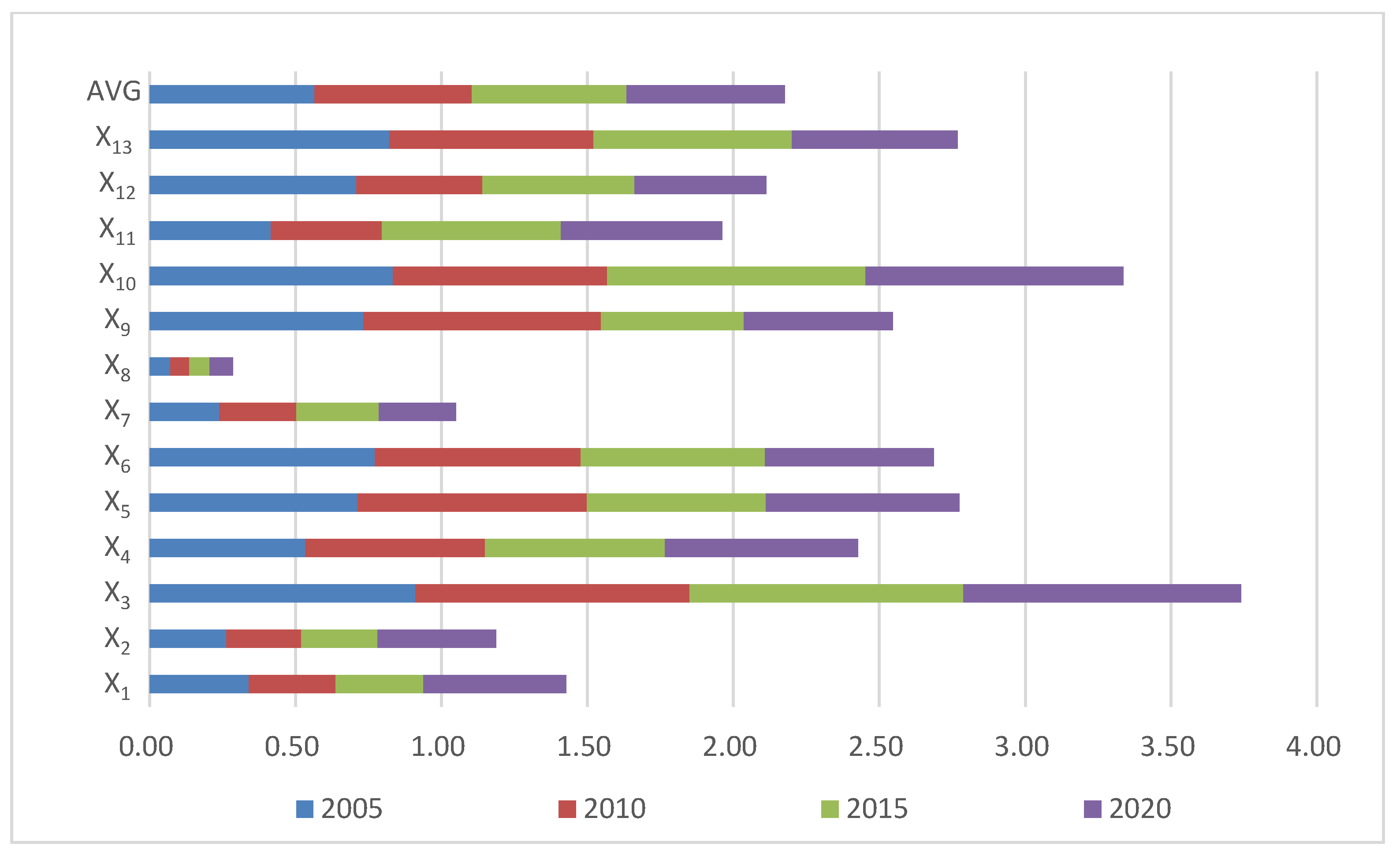
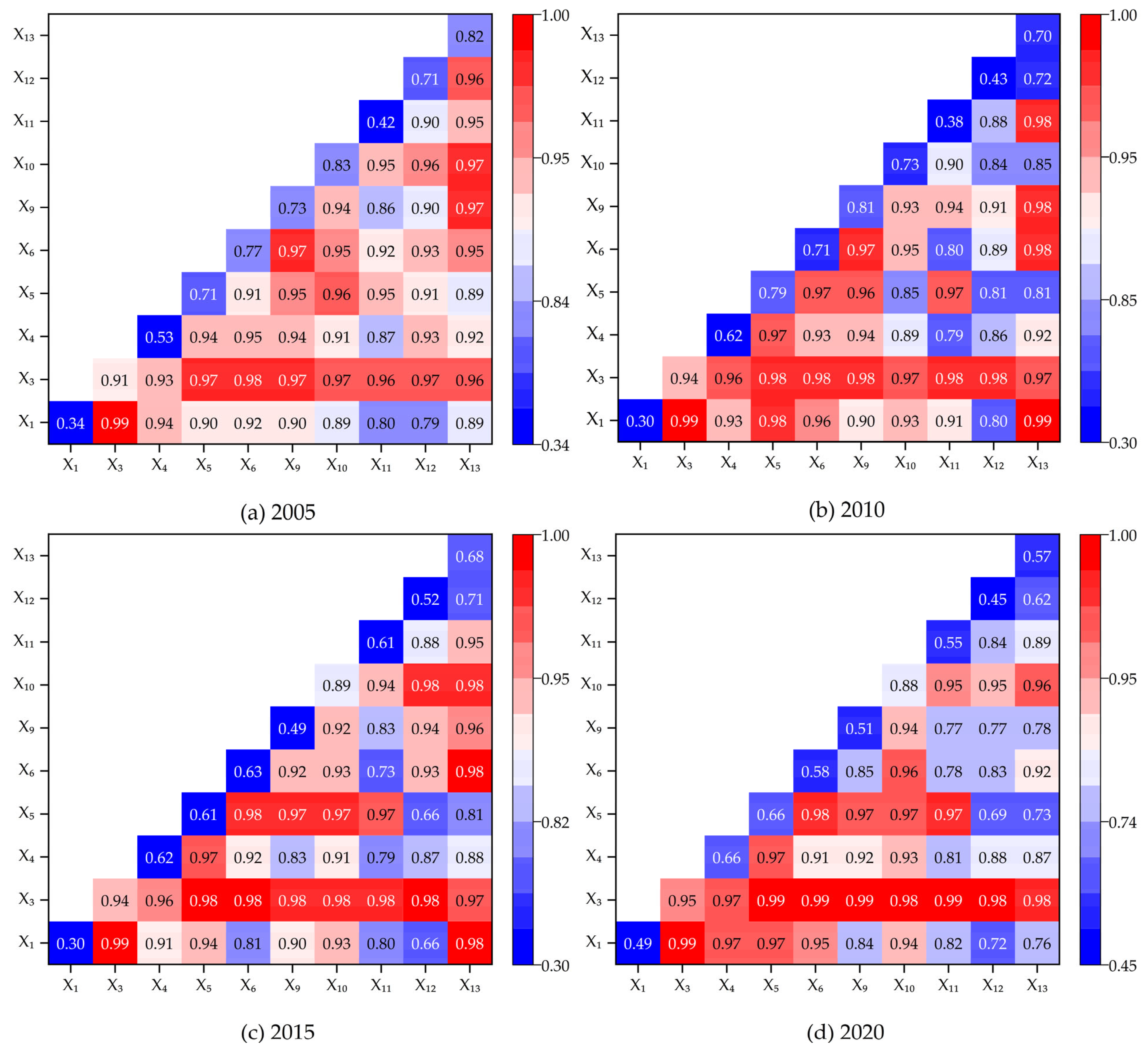
3.2.1. Impact Factor Identification

Based on the results of the factor detector, it was found that the mean height of the X8 did not exceed the 0.1 significance test level, which led to its elimination. All other factors passed the significance test at the 0.1 level. The results indicate that various factors, including socio-economic development, population agglomeration, residents’ financial capability, terrain conditions, investment intensity, openness, industrial structure quality, and natural resource conditions, influence the intensity of land development in the study area to varying extents. During the four years of study, X2 and X7 did not pass the 0.01 level of significance test. It is apparent that the factors X2, which represents average land GDP, and X7, which represents terrain undulation, degree have a weak ability to explain the dependent variable. Thus, these two factors were once again removed. A closer investigation of the q-values of the 99% significance factors reveals (Figure 7) the cumulative strength order of the drivers within the study time frame was X3 > X10 > X5 > X13 > X6 > X9 > X4 > X12 > X11 > X1. The effects of the factors exhibited varying intensities with time in each study year. However, the top seven factors surpassed the cumulative mean. These factors are population density, public finance budget expenditure per sq.km., total retail sales of consumer goods per capita, cultivated land area per capita, per capita urban and rural residents’ savings deposit balance, completed fixed asset investment per sq. km., and per capita land development and utilization area. X3 population density is the primary factor influencing land development in Shandong Province counties, with an explanatory power exceeding 91%, which is significantly higher than the other factors.

3.2.2. Influence Factor Interaction Detection

From the findings on the interaction detection of factors influencing land development intensity in Shandong Province’s counties between 2005 and 2020 (Figure 8), it is apparent that the level of interaction varies significantly across years and factors. The outcomes of the factor interactions revealed two-factor enhancement or nonlinear enhancement. This implies that the impact of each factor following two-by-two interactions was greater than that of a single factor or greater than the sum of the impacts of the factors when acting individually. This indicates that several factors have combined to influence the evolution of land development intensity of counties in Shandong Province.
From the perspective of the specific performance of the factor interaction in the study years, X1∩X4 and X11 in 2005 underwent nonlinear enhancement, X1∩X4, X11 and X11∩X12 in 2010 underwent nonlinear enhancement, X1∩X5 and X9 in 2015 underwent nonlinear enhancement, and those in 2020 all underwent two-factor enhancement. Based on the specific force of factor interactions in each study year, it can be concluded that the most dominant interactions in 2005 and 2015 were X1∩X3, with an explanatory degree of 0.99. This indicates that both GDP per capita and population density were the primary determinants that jointly led to land development in those years. In 2010, X1∩X3, X13 showed an explanatory degree of 0.99, signifying that GDP per capita, population density, and cultivated land area per capita were the primary co-drivers of land development during this time period. X3∩X1, X5, X6, X9, X11 explains 99% of the county’s land development in 2020. This suggests factors such as population density, GDP per capita, total retail sales of consumer goods per capita, per capita urban and rural residents’ savings deposit balance, completed fixed asset investment per sq. km., and gross exports per sq. km. collectively contributed to the county’s land development in that year. Overall, there is a high level of diversity in the factors that affect land development within the study area. However, it is the combined influence of X1 and X3, along with their interactions with other factors, that have the greatest significance.

3.2.3. Spatial Heterogeneity of Drivers

Further spatially differentiated parameter estimation was carried out for the two primary factors, GDP per capita and population density. To minimize the effect of subjective factors [71], and to ensure that within-category differences are small while between-category differences are maximized [71,72], the natural breaks (Jenks) method was chosen to visually present the results. Calculations revealed that the adjusted R2 of the model yielded values of 0.97, 0.97, 0.97, and 0.98 for the four respective time periods, with condition numbers ranging from 3.13 to 18.25. The multicollinearity diagnostic was passed by the model and the goodness of fit was found to be more satisfactory. This also reinforces the credibility of factor detection results. It indicates that the model can profoundly elucidate the spatially differentiated features of the drivers affecting land development intensity patterns in Shandong Province’s counties. As evidenced by the spatiotemporal distribution graph, there are significant variations in the changes in regression coefficients between years, counties, and impact factors.
The regression coefficient of GDP per capita of counties in Shandong Province experienced a decline followed by an increase between the years 2005 and 2020 (Figure 9). Additionally, the lowest value of the coefficient reveals a general decreasing trend. At the spatial distribution level, regression coefficients in 2005 exhibited an overarching trend of growth from the center-east to the surrounding areas. Additionally, there was a high-value cluster located in the northwest, which gradually decreased towards the southwest. In 2010, the regression coefficients demonstrated an “M-shaped” pattern from the southwest to the northeast, with a decline in the north and a rise in the south. The north and south regions respectively contained low and high values, with Yantai Laiyang and Haiyang City marked as minor sub-high-value zones. The extent of the high-value cluster area decreased and shifted from the northwest to the southeast between 2005 and 2010. In 2015, the regression coefficients generally showed an “S-shaped” trend from the north-east to the west, decreasing towards the north, increasing towards the south, and coalescing into a high-value cluster in the south and southeast. The southern high-value cluster area decreased while the northern low-value cluster area extended to the west between 2010 and 2015. In 2020, both the areas of high-value agglomeration and low-value agglomeration showed an expansion in the regression coefficient, while displaying an irregular transition. This highlights the volatility and high sensitivity of the impact of the economic development level on the intensity of land development in the counties of Shandong Province during this period.
It can be seen that the regression coefficients of population density show an overall increasing trend from 2005 to 2020, when examining the temporal changes of the regression coefficients of population density in the counties of Shandong Province (Figure 10). The regression coefficients are consistently rising in all years except for a minor decline in 2015. In terms of spatial distribution, the regression coefficients of population density exhibit higher values in the western region and lower values in the eastern region, indicating a clear east–west divide. The regression coefficients for population density in 2005 exhibited a general increasing trend from the east-central to north-western and eastern regions of the country, ultimately culminating in a high-value agglomeration in the northern parts. This signals the overall transitional nature of the spatial impact of population density on land development intensity within Shandong Province counties during the given period. The distribution of agglomerations with high and low values for the regression coefficients of population density in 2010, 2015, and 2020 exhibits similarity. The high-value clusters are predominantly found in the northern and southern regions of the study area, with low-value clusters located mainly in the east-central region. This signifies the general transitional effect of the population concentration’s spatial influence on the level of land development observed in the counties of Shandong Province throughout this period. Overall, certain county areas within Dongying City exhibit the strongest correlation between population density and land development intensity between 2005 and 2020.

4. Discussion

4.1. Analysis of Causes of Change

Earlier studies have used spatial autocorrelation analyses [36], ordinary least squares and geographically weighted regression methods [25], the Spatial Dubin Model [35], and the three-dimensional trend surface [28], etc. The analysis indicates that the factors driving land development intensity in counties primarily comprise population, economy, and industry, which result from various factors [35,37,38,39,40,53,54,55,56,57]. This result aligns with our findings. We offer a more integrated perspective of the value of land development intensity, building on the well-established methodology of existing studies. Meanwhile, by shielding drivers from the effects of multicollinearity, we identify the two most influential drivers. The research discovered a correlation between the intensity of construction land development in the county and both GDP per capita and population density.
Gross domestic product (GDP) is a significant measure for gauging the level of socio-economic development. Growth in GDP stimulates consumption levels, which in turn contributes to the enhancement of land development upgrading. The economic development of counties in Shandong Province exhibits a robust synergy with land development, which is manifested in the process of land development agglomeration, diffusion, and adaptation in the county space. The impact of GDP per capita on land development intensity in Shandong Province’s counties diminishes steadily during the study period, but displays some indications of resurgence. This is explained by the fact that once a certain level of socio-economic development is reached, it becomes difficult for some counties to develop land further, resulting in a slowdown in the growth rate of development intensity.
Population density serves as a critical indicator of the concentration of a population. Demographic shifts impact demands for land use [73], subsequently influencing the progression of county land development. There was an increasing impact of population density on land development intensity of counties in Shandong Province within the study period. This is attributed to the increasing challenges of an aging population and low fertility rates, among other factors. This, along with the enforcement of national strategies such as the two-child benefit, has influenced demographic transformation. Furthermore, the 2019 outbreak of the novel coronavirus significantly impeded the economy’s smooth operation, and caused a substantial reduction in the industrial output of the counties. This reduction led to a substantial drop in the intensity of land output, which had some impact on the spatial and time disparities related to land development of counties in Shandong Province.

4.2. Recommendations for Land Development in the County

Regardless of the degree of land development, all counties and districts should adhere to the principle of adapting to local conditions and respond positively to national macro policies. Differentiated development and management should be combined and synergized to establish a land space system with complementary advantages and high-quality development. At the same time, the development of county land should be coordinated with regional social, economic, and environmental benefits [74] in order to encourage the scientific, rational, and sustainable use of said land.
In counties with high current levels of development intensity, measures should be adopted to rationalize enhancement and protection, while strengthening the dual-control management of both the overall amount and the intensity of land development, making sure to scientifically define the boundaries of urban growth, and implementing land development quotas [75]. Strict control should be exercised over the indiscriminate expansion of arable land development that may occur upon reaching the threshold for development intensity. The role of provincial capitals and core cities in gathering and driving should be maximized, and their intensive and effective utilization promoted. At the same time, respect for objective laws of development maintains a balance between green ecological construction and socio-economic development of county land, and promotes the redevelopment of underutilized land [76,77,78].
For counties with moderate levels of current development intensity, the consolidation of industry and promotion of consistent advancement is recommended. Based on the ratio of land utilized for development, the carrying capacity of the population and the current land use output, this should be accompanied by the potential for land development alongside the creation of a land development strategy and a land usage evaluation mechanism, formulated using a scientific approach. This enhances the interoperability and interconnection of land development among neighboring counties to bring together the surrounding industries and talents, and to create highly valuable cluster areas. Simultaneously, it enhances independent innovation and consistently constructs and nurtures a distinctive industrial framework. The economic growth and industrial structural optimization in parallel should be promoted, while also steadily advancing the development of sustainable land.
Policy support and strengthening investment and construction for counties with low levels of current development intensity should be implemented. Effectively implementing the appropriate national and local policies will enhance industrial support and talent introduction. The amount of newly arable land being converted to development land should be expanded whilst imposing rigorous enforcement of the national policy on the balance of arable land occupation and compensation [79]. Simultaneously, we actively encourage fixed asset investment and the rigorous enforcement of industrial development benefits and public financial expenditure standards, and endorse the growth of small and medium-sized enterprises. Furthermore, the program facilitates the retrieval of various resource components, enhances infrastructure development, promotes the growth of the tertiary sector, and strengthens the overall competitiveness of the county.

4.3. Research Limitations and Prospects

There exist deficiencies in this research, predominantly in the domain of policy impact. Policy factors, such as redevelopment of low-value land and joint control of total volume and intensity, noticeably affect land development. However, entirely quantifying such measures is challenging and will require further improvement in upcoming studies. Furthermore, there is potential for further development of the research methodology, given the complexity of the study site and the challenges of tracking data over time. The geographical and temporal weighted regression model will be introduced in the follow-up study to further explore the spatiotemporal relationship between variables.

5. Conclusions

This study examines the development of spatiotemporal patterns in land development intensity across counties in Shandong Province, highlighting the interaction and spatiotemporal heterogeneity of factors. The main conclusions are as follows: The land development intensity value of counties in Shandong Province from 2005 to 2020 has exhibited a consistent upward trend. Most of the areas with high levels of development intensity are situated in the two central cities of Jinan and Qingdao. Specifically, they are concentrated in the three districts of Lixia, Shinan, and Shibei in Jinan and Qingdao. Counties with a medium level of development intensity are primarily situated in Zibo, Weifang, and Linyi, as well as other cities, such as Zibo’s Linzi District, Weifang’s Weicheng District, and Linyi’s Lanshan District. The counties with a low level of development intensity are predominantly located in the provincial capital, the periphery of Lunan Economic Circle, and the inland regions of Jiaodong Economic Circle. This demonstrates that the distribution of land development intensity in the counties of Shandong Province aligns with the regional development strategy of “one group, two centers and three circles”. High (low) value clusters are concentrated in core hot (cold) counties, driving some of the surrounding counties towards radial development. This has led to a reduction in the imbalance of development in the counties. Furthermore, we emphasize that the alteration in land development intensity across counties in Shandong Province is not attributable to a singular factor, but rather a complex outcome resulting from the interaction of several factors. Socio-economic development, the degree of population agglomeration, the level of financial resources of the population, topographical conditions, financial investment intensity, opening up to the outside world, the quality of the industrial structure, and natural resource endowment all affect the intensity of land development in the study area to varying degrees. Amongst these factors, GDP per capita and population density serve as the primary catalysts for land development in counties within Shandong Province. Based on this, this study proposes a series of development proposals for counties with different land development intensities, with a view to providing scientific references for the formulation of government policy on the optimization of land spatial allocation and sustainable development of land resources.

Author Contributions

Conceptualization, C.Z. and R.G.; methodology, C.Z. and R.G.; software, R.G.; validation, C.Z., R.G. and W.Y.; formal analysis, C.Z. and R.G.; investigation, C.Z. and R.G.; resources, C.Z. and W.Y.; data curation, R.G.; writing—original draft preparation, C.Z. and R.G.; writing—review and editing, J.L. and W.Y.; visualization, R.G.; supervision, L.P. and W.Y.; project administration, C.Z. and L.P.; funding acquisition, C.Z. All authors have read and agreed to the published version of the manuscript.

Funding

This research was funded by the Social Science Planning and Research Project of Shandong Province (Project approval No. 18CSJJ12).

Institutional Review Board Statement

Not applicable.

Informed Consent Statement

Not applicable.

Data Availability Statement

The data presented in this study are available on request from the second author.

Acknowledgments

We sincerely thank the editor and the reviewers for their helpful comments and suggestions about our manuscript. This work was also assisted by the Faculty of Economics and the Centre of Excellence in Econometrics at Chiang Mai University.

Conflicts of Interest

The authors declare no conflict of interest.

References

  1. Zhang, Q.; Yue, D.; Fang, M.; Yu, Q.; Huang, Y.; Su, K.; Ma, H.; Wang, Y. Study on sustainability of land resources in Dengkou County based on emergy analysis. J. Clean. Prod. 2018, 171, 580–591. [Google Scholar] [CrossRef]
  2. Cao, Y.; Zhang, X.; Zhang, X.; Li, H. The incremental construction land differentiated management framework: The perspective of land quota trading in China. Land Use Policy 2020, 96, 104675. [Google Scholar] [CrossRef]
  3. He, Z.; Ling, Y.; Fürst, C.; Hersperger, A.M. Does zoning contain built-up land expansion? Causal evidence from Zhangzhou City, China. Landsc. Urban Plan. 2022, 220, 104339. [Google Scholar] [CrossRef]
  4. Liu, Y.; Fang, F.; Li, Y. Key issues of land use in China and implications for policy making. Land Use Policy 2014, 40, 6–12. [Google Scholar] [CrossRef]
  5. Jiang, H.; Guo, H.; Sun, Z.; Xing, Q.; Zhang, H.; Ma, Y.; Li, S. Projections of urban built-up area expansion and urbanization sustainability in China’s cities through 2030. J. Clean. Prod. 2022, 367, 133086. [Google Scholar] [CrossRef]
  6. Gao, J.; Liu, Y.; Chen, Y. Land cover changes during agrarian restructuring in Northeast China. Appl. Geogr. 2006, 26, 312–322. [Google Scholar] [CrossRef]
  7. Ding, H.; Wang, R.-C.; Wu, J.-P.; Zhou, B.; Shi, Z.; Ding, L.-X. Quantifying Land Use Change in Zhejiang Coastal Region, China Using Multi-Temporal Landsat TM/ETM+ Images. Pedosphere 2007, 17, 712–720. [Google Scholar] [CrossRef]
  8. Zong, S.; Hu, Y.; Bai, Y.; Guo, Z.; Wang, J. Analysis of the distribution characteristics and driving factors of land use conflict potentials in the Bohai Rim coastal zone. Ocean Coast. Manag. 2022, 226, 106260. [Google Scholar] [CrossRef]
  9. Gong, J.; Chen, W.; Liu, Y.; Wang, J. The intensity change of urban development land: Implications for the city master plan of Guangzhou, China. Land Use Policy 2014, 40, 91–100. [Google Scholar] [CrossRef]
  10. Li, Y.; Chen, C.; Wang, Y.; Liu, Y. Urban-rural transformation and farmland conversion in China: The application of the environmental Kuznets Curve. J. Rural Stud. 2014, 36, 311–317. [Google Scholar] [CrossRef]
  11. Liu, J.; Liu, Y.; Yan, M. Spatial and temporal change in urban-rural land use transformation at village scale—A case study of Xuanhua district, North China. J. Rural Stud. 2016, 47, 425–434. [Google Scholar] [CrossRef]
  12. Wang, L.; Zhang, S.; Tang, L.; Lu, Y.; Liu, Y.; Liu, Y. Optimizing distribution of urban land on the basis of urban land use intensity at prefectural city scale in mainland China. Land Use Policy 2022, 115, 106037. [Google Scholar] [CrossRef]
  13. Zhang, B.; Li, W.; Zhang, C. Analyzing land use and land cover change patterns and population dynamics of fast-growing US cities: Evidence from Collin County, Texas. Remote Sens. Appl. Soc. Environ. 2022, 27, 100804. [Google Scholar] [CrossRef]
  14. Chen, W.; Zeng, J.; Li, N. Change in land-use structure due to urbanisation in China. J. Clean. Prod. 2021, 321, 128986. [Google Scholar] [CrossRef]
  15. Ge, W.; Xiaoqiu, L.; Yingjie, G.; Chen, Z.; Bingkun, W.; Xiangyu, L.; Xintong, L. How does land consolidation drive rural industrial development? Qualitative and quantitative analysis of 32 land consolidation cases in China. Land Use Policy 2023, 130, 106664. [Google Scholar]
  16. Wang, R.; Tan, R. Patterns of rural collective action in contemporary China: An archetype analysis of rural construction land consolidation. J. Rural Stud. 2020, 79, 286–301. [Google Scholar] [CrossRef]
  17. Dongdong, Y.; Xin, Z.; Anderson, B.C. Integrating Sponge City Requirements into the Management of Urban Development Land: An Improved Methodology for Sponge City Implementation. Water 2022, 14, 1156. [Google Scholar]
  18. Josip, K.; Miodrag, R. Development of a Methodology and Model for Land Administration Data Dissemination Processes. Land 2023, 12, 711. [Google Scholar]
  19. Ashish, G.; Piyush, T. An analysis of land and property development models, and stakeholders: A case of National Capital Region, India. Land Use Policy 2022, 117, 106110. [Google Scholar]
  20. Shen, Z.; Xu, X.; Xu, S.; Sun, D. A comparative study of land development patterns and regional thermal environments (RTEs) in typical urban agglomerations of China and America: A case study of Beijing-Tianjin-Hebei (BTH) and Boswash. Sci. Total Environ. 2022, 803, 149735. [Google Scholar] [CrossRef] [PubMed]
  21. Yanling, C.; Cuicui, T.; Qian, Z.; Wei, H.; Yongzheng, C. Analysis of land use/cover change in Guangdong-Hong Kong-Macao greater bay area from 1979 to 2016. Int. Conf. Environ. Remote Sens. Big Data 2021, 12129, 95–106. [Google Scholar]
  22. Zhou, Y.; Li, Y.; Xu, C. Land consolidation and rural revitalization in China: Mechanisms and paths. Land Use Policy 2020, 91, 104379. [Google Scholar] [CrossRef]
  23. Valtonen, E.; Falkenbach, H.; van der Krabben, E. Risk management in public land development projects: Comparative case study in Finland, and the Netherlands. Land Use Policy 2017, 62, 246–257. [Google Scholar] [CrossRef]
  24. O’Brien, P.; Lord, A.; Dembski, S. How do planners manage risk in alternative land development models? An institutional analysis of land development in the Netherlands. Land Use Policy 2020, 91, 104409. [Google Scholar] [CrossRef]
  25. Xin, H.; Xiaojun, H.; Mengmeng, L.; Bo, W.; Yonghua, Z. Spatial-temporal Dynamics and Driving Forces of Land Development Intensity in the Western China from 2000 to 2015. Chin. Geogr. Sci. 2020, 30, 16–29. [Google Scholar]
  26. Tan, S.; Liu, Q.; Han, S. Spatial-temporal evolution of coupling relationship between land development intensity and resources environment carrying capacity in China. J. Environ. Manag. 2022, 301, 113778. [Google Scholar] [CrossRef]
  27. Tang, J.; Gao, H.; Song, X.; Xu, H. Convergence or divergence between small towns and villages: A perspective from changes in built-up land development intensity. Habitat Int. 2023, 138, 102874. [Google Scholar] [CrossRef]
  28. Zaiyan, L.; Peiji, S. Analysis of changes in spatial pattern of development intensity of urban and rural construction land in Lanzhou-Xining urban agglomeration and the factors affecting it. J. Ecol. Rural. Environ. 2020, 36, 450–458. (In Chinese) [Google Scholar]
  29. Wellmann, T.; Haase, D.; Knapp, S.; Salbach, C.; Selsam, P.; Lausch, A. Urban land use intensity assessment: The potential of spatio-temporal spectral traits with remote sensing. Ecol. Ind. 2018, 85, 190–203. [Google Scholar] [CrossRef]
  30. Ferdous, N.; Bhat, C.R. A spatial panel ordered-response model with application to the analysis of urban land-use development intensity patterns. J. Geogr. Syst. 2013, 15, 1–29. [Google Scholar] [CrossRef]
  31. Li, Z.; Yu, X.; Gong, C. Intensity Change in Cultivated Land Use in Shandong Province from 1980 to 2010. IERI Procedia 2013, 5, 140–146. [Google Scholar] [CrossRef]
  32. Li, X.; Wu, K.; Yang, Q.; Hao, S.; Feng, Z.; Ma, J. Quantitative assessment of cultivated land use intensity in Heilongjiang Province, China, 2001–2015. Land Use Policy 2023, 125, 106505. [Google Scholar] [CrossRef]
  33. Zhang, P.; Yang, D.; Qin, M.; Jing, W. Spatial heterogeneity analysis and driving forces exploring of built-up land development intensity in Chinese prefecture-level cities and implications for future Urban Land intensive use. Land Use Policy 2020, 99, 104958. [Google Scholar] [CrossRef]
  34. Di, X.; Hou, X.; Wang, Y.; Wu, L. Spatial-temporal Characteristics of Land Use Intensity of Coastal Zone in China during 2000–2010. Chin. Geogr. Sci. 2015, 25, 51–61. [Google Scholar] [CrossRef]
  35. Xie, W.; Jin, W.; Chen, K.; Wu, J.; Zhou, C. Land Use Transition and Its Influencing Factors in Poverty-Stricken Mountainous Areas of Sangzhi County, China. Sustainability 2019, 11, 4915. [Google Scholar] [CrossRef]
  36. Xiao, Y.; Gong, P. Removing spatial autocorrelation in urban scaling analysis. Cities 2022, 124, 103600. [Google Scholar] [CrossRef]
  37. Xu, F.; Wang, Z.; Chi, G.; Zhang, Z. The impacts of population and agglomeration development on land use intensity: New evidence behind urbanization in China. Land Use Policy 2020, 95, 104639. [Google Scholar] [CrossRef]
  38. Chufu, M.; Limao, W.; Qiushi, Q.; Yebing, F.; Hong, Z. Factors Driving the Expansion of Construction Land: A Panel Data Study of Districts and Counties in Ningbo City, China. J. Resour. Ecol. 2018, 9, 365–373. [Google Scholar] [CrossRef]
  39. Ouyang, D.; Zhu, X.; Liu, X.; He, R.; Wan, Q. Spatial Differentiation and Driving Factor Analysis of Urban Construction Land Change in County-Level City of Guangxi, China. Land 2021, 10, 691. [Google Scholar] [CrossRef]
  40. Li, Y.; Li, Y.; Karácsonyi, D.; Liu, Z.; Wang, Y.; Wang, J. Spatio-temporal pattern and driving forces of construction land change in a poverty-stricken county of China and implications for poverty-alleviation-oriented land use policies. Land Use Policy 2020, 91, 104267. [Google Scholar] [CrossRef]
  41. Liu, Z.; Chen, J.; Ni, J.; Zhang, L. Restriction Analysis of Residual Capacity of Intersection on Land Development Intensity. J. Transp. Syst. Eng. Inf. Technol. 2011, 11, 73–78. [Google Scholar] [CrossRef]
  42. Cao, R.-f.; Zhang, A.-l.; Cai, Y.-y.; Xie, X.-x. How imbalanced land development affects local fiscal condition? A case study of Hubei Province, China. Land Use Policy 2020, 99, 105086. [Google Scholar] [CrossRef]
  43. Xu, Y.; Tang, Q.; Fan, J.; Bennett, S.J.; Li, Y. Assessing construction land potential and its spatial pattern in China. Landsc. Urban Plan. 2011, 103, 207–216. [Google Scholar] [CrossRef]
  44. Jinfeng, W.; Chengdong, X. Geoprobes: Principles and Prospects. J. Geogr. 2017, 72, 116–134. (In Chinese) [Google Scholar]
  45. Propastin, P. Modifying geographically weighted regression for estimating aboveground biomass in tropical rainforests by multispectral remote sensing data. Int. J. Appl. Earth Obs. Geoinf. 2012, 18, 82–90. [Google Scholar] [CrossRef]
  46. Jing, H.; Yang, R.; Kun, Y.; Wei, L.; Teng, M. Quantitative attribution of key town layout in China based on geodetector and GWR model. Adv. Geosci. 2020, 39, 1687–1697. (In Chinese) [Google Scholar]
  47. Xinjian, D.; Junhai, M. Study on the Indicator System for Evaluating Economic Development Efficiency in Shandong Province. Energy Procedia 2011, 5, 900–904. [Google Scholar] [CrossRef]
  48. Yanjun, L.; Huisheng, Y.; Degang, L.; Liyuan, Z. Mechanisms of spatial differentiation in the evolution of construction land development intensity patterns in Northeast China. J. Geogr. 2018, 73, 818–831. (In Chinese) [Google Scholar]
  49. Chen, J.; Gao, J.; Chen, W. Urban land expansion and the transitional mechanisms in Nanjing, China. Habitat Int. 2016, 53, 274–283. [Google Scholar] [CrossRef]
  50. Ding, C.; Lichtenberg, E. Land and Urban economic growth in China. J. Reg. Sci. 2011, 51, 299–317. [Google Scholar] [CrossRef]
  51. Li, H.; Wei, Y.D.; Liao, F.H.; Huang, Z. Administrative hierarchy and urban land expansion in transitional China. Appl. Geogr. 2015, 56, 177–186. [Google Scholar] [CrossRef]
  52. Lin, G.C.S. Toward a post-socialist city? Economic tertiarization and urban reformation in the Guangzhou Metropolis, China. Eurasian Geogr. Econ. 2004, 45, 18–44. [Google Scholar] [CrossRef]
  53. Shi, S.; Chen, Z.H.; Qi, J.; Liu, Y. Characteristics of Landscape (Land Use) Change and its Driving Force in County—A Case Study of Shunyi District of Beijing. Appl. Mech. Mater. 2014, 692, 115–120. [Google Scholar] [CrossRef]
  54. Qiao, W.; Huang, X. How does transportation development affect environmental performance? Evidence from Hainan Province, China. Cities 2022, 129, 103835. [Google Scholar] [CrossRef]
  55. Liu, H.; Zheng, M.; Liu, J.; Zheng, X. Sustainable land use in the trans-provincial marginal areas in China. Resour. Conserv. Recycl. 2020, 157, 104783. [Google Scholar] [CrossRef]
  56. Fang, G.; Yang, J.; Su, H.M. Dynamic Analysis of Land Use/Cover Change in Dangshan County. Adv. Mater. Res. 2011, 356–360, 2874–2879. [Google Scholar] [CrossRef]
  57. Dekun, D.; Jinping, L.; Shuzhong, G. Expansion and Change of Rural Settlements in Traditional Agricultural Regions: Based on Village Investigation in Pingdu County. Chin. J. Popul. Resour. Environ. 2008, 6, 55–61. [Google Scholar] [CrossRef]
  58. Wang, S.; Fang, C.; Wang, Y.; Huang, Y.; Ma, H. Quantifying the relationship between urban development intensity and carbon dioxide emissions using a panel data analysis. Ecol. Ind. 2015, 49, 121–131. [Google Scholar] [CrossRef]
  59. Qingke, Y.; Lei, W.; Yongle, L.; Yeting, F.; Chao, L. Urban land development intensity: New evidence behind economic transition in the Yangtze River Delta, China. J. Geogr. Sci. 2022, 32, 2453–2474. [Google Scholar]
  60. Guanhai, G.; Bin, W.; Wenzhu, Z.; Rucheng, L.; Xiaoling, F.; Wenhui, L.; Caiping, P.; Shengquan, L. Comparing machine learning methods for predicting land development intensity. PLoS ONE 2023, 18, e0282476. [Google Scholar]
  61. Fengying, L.; Zhiqiang, P.; Guangyao, D. Study on the Measurement of the Level of Rural Revitalization and Spatial Correlation Effect--Taking Gansu Province as an Example. Stat. Decis. Mak. 2022, 38, 63–68. (In Chinese) [Google Scholar]
  62. Wang, Y.; Li, L. Forecasts of Urban Construction Land Scale based on Driving Force Analysis. In Proceedings of the 2017 5th International Conference on Mechatronics, Materials, Chemistry and Computer Engineering (ICMMCCE 2017), Chongqing, China, 24–25 July 2017. [Google Scholar]
  63. Jin, X.; Zhang, H.; Zhou, Y. Comparison analysis of agricultural land gradation evaluation based on different weight making methods. Geoinformatics 2008, 7145, 225–233. [Google Scholar]
  64. Ripley, B.D. Spatial Processes: Models and Applications. J. Am. Stat. Assoc. 1984, 79, 238. [Google Scholar] [CrossRef]
  65. Kumari, M.; Sarma, K.; Sharma, R. Using Moran’s I and GIS to study the spatial pattern of land surface temperature in relation to land use/cover around a thermal power plant in Singrauli district, Madhya Pradesh, India. Remote Sens. Appl. Soc. Environ. 2019, 15, 100239. [Google Scholar] [CrossRef]
  66. Rossi, R.E.; Mulla, D.J.; Journel, A.G.; Franz, E.H. Geostatistical Tools for Modeling and Interpreting Ecological Spatial Dependence. Ecol. Monogr. 1992, 62, 277–314. [Google Scholar] [CrossRef]
  67. Zhao, R.; Zhan, L.; Yao, M.; Yang, L. A geographically weighted regression model augmented by Geodetector analysis and principal component analysis for the spatial distribution of PM2.5. Sustain. Cities Soc. 2020, 56, 102106. [Google Scholar] [CrossRef]
  68. Jiang, H.; Yin, J.; Qiu, Y.; Zhang, B.; Ding, Y.; Xia, R. Industrial Carbon Emission Efficiency of Cities in the Pearl River Basin: Spatiotemporal Dynamics and Driving Forces. Land 2022, 11, 1129. [Google Scholar] [CrossRef]
  69. Huang, H.; Zhou, Y.; Qian, M.; Zeng, Z. Land Use Transition and Driving Forces in Chinese Loess Plateau: A Case Study from Pu County, Shanxi Province. Land 2021, 10, 67. [Google Scholar] [CrossRef]
  70. Brunsdon, C.; Fotheringham, A.S.; Charlton, M.E. Geographically Weighted Regression: A Method for Exploring Spatial Nonstationarity. Geogr. Anal. 1996, 28, 281–298. [Google Scholar] [CrossRef]
  71. Siyu, L.; Jinyan, Z.; Zhaopeng, W. A study of oasis land use and its spatial conflict in Jinghe County. J. Ecol. Rural. Environ. 2022, 38, 428–436. (In Chinese) [Google Scholar]
  72. Jinghu, P.; Ying, L. Spatial Field Energy Measurement of Chinese Cities Above Prefecture Level Based on Accessibility and Field Strength Modeling. Hum. Geogr. 2014, 29, 80–88. (In Chinese) [Google Scholar]
  73. Hadiyanto; Dety Novia Utami, N.; Supriatna, S.; Anggrahita, H.; Maryono; Warsito, B. Multi Criteria Analysis of Built-Up Land Suitability in Sleman Regency, Special Region of Yogyakarta Province. E3S Web Conf. 2018, 73, 03005. [Google Scholar]
  74. Zhang, W.; Shi, P.; Tong, H. Research on Construction Land Use Benefit and the Coupling Coordination Relationship Based on a Three-Dimensional Frame Model—A Case Study in the Lanzhou-Xining Urban Agglomeration. Land 2022, 11, 460. [Google Scholar] [CrossRef]
  75. Fang, L.; Tian, C. Construction land quotas as a tool for managing urban expansion. Landsc. Urban Plan. 2020, 195, 103727. [Google Scholar] [CrossRef]
  76. Krejčí, T.; Dostál, I.; Havlíček, M.; Martinát, S. Exploring the hidden potential of sugar beet industry brownfields (case study of the Czech Republic). Transp. Res. Part DTransp. Environ. 2016, 46, 284–297. [Google Scholar] [CrossRef]
  77. Wang, H.; Shen, Q.; Tang, B.-S.; Skitmore, M. An integrated approach to supporting land-use decisions in site redevelopment for urban renewal in Hong Kong. Habitat Int. 2013, 38, 70–80. [Google Scholar] [CrossRef]
  78. Wang, Y.; Zhu, X.; Li, L.; Wu, B. Reasons and Countermeasures of Traffic Congestion under Urban Land Redevelopment. Procedia-Soc. Behav. Sci. 2013, 96, 2164–2172. [Google Scholar] [CrossRef]
  79. Zhou, Y.; Huang, X.; Zhong, T.; Chen, Y.; Yang, H.; Chen, Z.; Xu, G.; Niu, L.; Li, H. Can annual land use plan control and regulate construction land growth in China? Land Use Policy 2020, 99, 105026. [Google Scholar] [CrossRef]
Figure 1. Schematic map of the study area.
Sustainability 15 15069 g001
Figure 2. Changes in data on the administrative division of the study area.
Sustainability 15 15069 g002
Figure 3. Average land development intensity values per county in Shandong Province from 2005 to 2020.
Sustainability 15 15069 g003
Figure 4. Spatial and temporal distribution of county land development intensity in Shandong Province, 2005–2020.
Sustainability 15 15069 g004
Figure 5. Three-dimensional trend surface analysis of county land development intensity patterns in Shandong Province, 2005–2020.
Sustainability 15 15069 g005
Figure 6. Spatial Getis–Ord G i * distribution of county land development intensity in Shandong Province, 2005–2020.
Sustainability 15 15069 g006
Figure 7. Results of detection of influencing factors of county land development intensity in Shandong Province, 2005–2020.
Sustainability 15 15069 g007
Figure 8. Interaction detection results of influence factors of county land development intensity in Shandong Province, 2005–2020.
Sustainability 15 15069 g008
Figure 9. Spatial and temporal distribution of regression coefficients of per capita GDP of counties in Shandong Province, covering the period of 2005–2020.
Sustainability 15 15069 g009
Figure 10. Spatial and temporal distribution of regression coefficients of county population density in Shandong Province, 2005–2020.
Sustainability 15 15069 g010
Table 1. Data sources for county development intensity pattern evolution in Shandong Province.
ModulNo.Indicator TitlePropertyIndicator
Interpretation
Main Data Sources
development intensity1DLA+Development
land area
Centre for Resource and Environmental
Sciences and Data, Chinese Academy of
Sciences, National Geographic Information
Resources Catalogue Service System
2TA+Total area
3RP+Regional populationChina County Statistical Yearbook, Shandong Statistical Yearbook, Shandong Yearbook
4OV+Output value
driving factorsX1GDP per capita+Socio-economic
development
X2GDP per sq. km.+
X3Population density+Population
agglomeration
X4Per capita
land development and
utilization area
+China County Statistical Year-book, Centre for Resource and Environmental Sciences and Data, Chinese Academy of Sciences, National Geographic Information Resources Catalogue Service System
X5Total retail sales of
consumer goods per capita
+Residents’
financial capability
China County Statistical Year-book, Statistical yearbook of each city, official website of each city statistical office
X6Per capita urban and
rural residents’ savings
deposit balance
+
X7Topographic reliefTerrain
conditions
Geospatial data cloud, National Geographic Information Resources Catalogue Service System
X8Average elevation
X9Completed fixed asset
investment per sq. km.
+Investment
intensity
China County Statistical Year-book,
Shandong Statistical Year-book, Shandong Yearbook, Statistical yearbook of each city,
official website of each city statistical office
X10Public finance budget
expenditure per sq.km.
+
X11Gross exports per sq. km.+Openness
X12Share of secondary and tertiary industries+Industrial
structure quality
China County Statistical Year-book, Shandong Statistical Year-book, Shandong Yearbook
X13Cultivated land area
per capita
Natural
resource conditions
Centre for Resource and Environmental
Sciences and Data, Chinese Academy of
Sciences, National Geographic Information
Resources Catalogue Service System,
China County Statistical Year-book
Note: “+” is a positive indicator, representing a positive correlation with DLA; “−” is a negative indicator, representing a negative correlation with DLA.
Table 2. Moran’s I index of land development intensity of counties of Shandong Province, 2005–2020.
Parameters2005201020152020
Moran’s I Index0.510.430.420.45
Z Score10.499.169.279.56
p-value0.000.000.000.00
Disclaimer/Publisher’s Note: The statements, opinions and data contained in all publications are solely those of the individual author(s) and contributor(s) and not of MDPI and/or the editor(s). MDPI and/or the editor(s) disclaim responsibility for any injury to people or property resulting from any ideas, methods, instructions or products referred to in the content.

