Article

A Geospatial Analysis Model for the Selection of Post-Mining Land Uses in Surface Lignite Mines: Application in the Ptolemais Mines, Greece

by
Aikaterini Servou
1,
Nikolaos Paraskevis
1,
Christos Roumpos
1,* and
Francis Pavloudakis
2
1
Department of Mining Engineering and Closure Planning, Public Power Corporation of Greece, 104 32 Athens, Greece
2
Mineral Resources Engineering Department, School of Engineering, University of Western Macedonia, 501 00 Kozani, Greece
*
Author to whom correspondence should be addressed.
Sustainability 2023, 15(19), 14388; https://doi.org/10.3390/su151914388
Submission received: 17 August 2023 / Revised: 22 September 2023 / Accepted: 27 September 2023 / Published: 29 September 2023
(This article belongs to the Special Issue Sustainable Mining and Processing of Mineral Resources)

Abstract

:
Among the procedures included in surface mines’ closure, the determination of post-mining land uses constitutes one of the early but primary steps. This research aims to develop an algorithm for the selection of the most suitable land use spatial distribution in the post-mining area of a surface lignite mine in northern Greece. Considering the already reclaimed areas and the local socioeconomic conditions, six distinct criteria that concern physical local characteristics were selected and, in turn, spatially combined with parameters affecting the mining area. Mining experts attributed weights to the criteria regarding their importance for the examined land uses. The six criteria concerned physical local characteristics (slope, elevation, and distance from villages, rivers, roads, and transmission lines), while the parameters affecting the mining area referred to the type of ground (undisturbed or graded areas), existing infrastructure, and mine closure planning, emphasizing the final landscape of the mining area. The investigated land uses encompassed agricultural, forest, industrial (including buildings, infrastructure, and photovoltaic parks), and recreational parks. Through the application of a fuzzification algorithm within a geographical information system (GIS) environment, four land use suitability maps were generated, which were subsequently overlaid to derive a comprehensive suitability map. The final suitability map was derived from the integration of the mining parameters as spatial information into the algorithm. The findings indicate that, even though the land use suitability analysis could be derived from a mathematical model, the integration of qualitative information related to the mining specifications is necessary to produce more reliable results. The proposed algorithm can be used as a useful tool by decision-makers in the mining industry to plan post-mining reclamation based on suitable criteria.

1. Introduction

The energy Just Transition is a current concept that occupies the interests of most related coal and lignite mining companies and includes different multidimensional aspects: justice, employment, governance, public perception, and impact assessment [1]. In this context, proper management is needed in combination with the mine closure procedures [2,3] to ensure a transition that relieves economic decline and poverty [4]. In the post-mining period and the context of the environmental impact assessment, land reclamation is of primary importance and constitutes a multiparametric procedure including several phases. In turn, land reclamation presupposes the suitability assessment of each area to host a specific land use, dependent on the multiple influencing factors characterizing each area [5,6]. One of the main targets for each mining industry is to achieve the maximum suitability of post-mining land uses in combination with the minimum vulnerability to any hazards [7,8].
Mine closure includes several procedures, although no specific European regulations exist for its implementation [9]. In most cases, mine closure is based on the general mining legislation [10], as well as the Greek one, which is based on European legislation. Whatever legislation has been applied, the basic obligation of the state is to ensure that the closure will occur adequately and without any adverse environmental impacts. However, some standards and guidelines are not specifically for mine closure but useful for it, which are represented by the International Organizations for Standardization (ISO). Some indicative ones are ISO 14001:2015 [11], 14004:2016 [12], 14015:2001 [13], and 14055-1:2017 [14]. Although the specific standards are proposed by the ISO, the regulations could be changed, depending on the local conditions. One of the main stages of the mine closure is the decommissioning of lignite mining, which includes, alongside other stages, land repurposing. In this framework, post-mining land use and its early and sustainable planning are highly prioritized for most mining industries that have entered the closure phase.
Mined land repurposing (MLR) is a procedure for determining the post-mining land uses, elaborated upon simultaneously with the mining operations or after the mine closure [15,16]. It is widely known that mining operations affect land use changes through time in several ways [17,18], meaning that, after mining exploitation, the excavation or dumping areas could be transformed into other land use, such as agriculture, forest land, or recreational parks. Monitoring these changes over time highly contributes to determining the crucial parameters that affect the final decision on post-mining land uses [19]. The term “repurposing” declares the existence of more than one land use and includes a wide range of activities that should be followed [20]. Several countries in Europe, particularly former coal-producing countries, repurpose the areas in such a way as to preserve industrial heritage [21,22]. There are multiple benefits and contributions to the coal transition from land repurposing combined with spatial post-mine planning, which concerns climate change, the post-carbon economy and energy production, and the environmental regeneration of mining lands. In addition, land repurposing attracts new businesses and creates new jobs.
Several approaches, such as decision-making procedures, have been developed in the international literature diachronically for land use suitability assessment in surface mining areas. In this framework, spatial decision support systems (SDSS) combined with geographic information systems (GISs) [23], as well as multi-criteria decision analysis (MCDA) techniques, are extensively used for land use decision-making in post-mining areas [24]. The most common techniques applied to post-mining land use decision-making are the AHP, TOPSIS, and PROMETHEE methods [25,26,27]. Evolutionary and multi-objective optimization algorithms (e.g., genetic and particle swarm optimization algorithms) are widely used for land suitability assessment, combining spatial, economic, and social criteria. Some of these techniques are mathematical and heuristic algorithms. Linear programming (LP) and mixed-integer programming constitute the most common mathematical algorithms, whereas genetic algorithm (GA), simulated annealing (SA), and artificial neural network (ANN) constitute some of the heuristic ones. Multi-type ant colony optimization (MACO-MLA) is a technique for multi-land use allocation that has better performance than simulated annealing (SA) and the genetic algorithm (GA), especially regarding employment time [28].
In addition, several methods have been developed to correlate and evaluate criteria significance. A criterion may be equally important to each other, moderately strong, or extremely important. In this context, a combination of geographic information systems and ordered weighted averaging (GIS-OWA) techniques are used [29], of which the OWA technique constitutes a multi-criteria evaluation method and is used for the definition of the relative significance between the model variables and the order weights. The authors of [30] combined GIS with AHP to weigh the criteria and showed that the most important criteria to consider for the land suitability evaluation are the natural/physical ones. Furthermore, SWOT analysis has been proven a useful semi-quantitative method, as it allows the importation of internal and external factors into the suitability analysis [8]. The restrictive factors that define a land segment as unsuitable were evaluated through the Integrated Index Method and the Difference-Product Method and resulted in the fact that they operate reliably for evaluating the suitability of damaged mining land for land reclamation [31]. The multiple land use allocation problems are employed with multi-objective optimization techniques because they include many combinations regarding the different land uses and the very large number of raster surface pixels.
Studies that investigate land use suitability for the post-mining era, combining the local-topographical parameters with the engagement of stakeholders, are few in the international literature [32,33], and this is the research gap that the present paper aims to fill. More specifically, the local knowledge of experts and preferences are the crucial parameters that characterize the specific mining area and would enhance the social acceptance and success of rehabilitation efforts. Moreover, this study represents the first application of such an approach in Greek surface lignite mines, contributing to the innovative nature of this research. Previous studies have explored parameters influencing land use selection in the lignite surface mines of Public Power Corporation (PPC) under the following repurposing scenarios: (a) renewable energy production, (b) industrial production/waste, processing/workshops, services, and storage, (c) agriculture/horticulture/forestry, (d) recreation/tourism, and (e) office/research/technology parks [15]. The present study’s main objective is to assess the optimal spatial distribution of post-mining land uses by considering the already reclaimed areas, specific criteria, and experts’ judgment. In this framework, answers are sought to the following research questions:
  • How are the dynamic conditions in the mining area related to establishing the suitability criteria and, finally, to determining the post-mining land uses?
  • How do key parameters (e.g., environmental, mining, and socioeconomic) affect the final determination of the optimal land use selection?
  • How are the topographical–morphological criteria integrated with the additional mining criteria for determining land use suitability?
Criteria selection represents the multidimensionality that characterizes land use suitability assessment. The suitability criteria were selected by thinking about the environmental and local mining conditions [20,34]. Specifically, the paper investigates the spatial distribution of the criteria that determine each land use by prioritizing their values and calculating the maximum suitability score for each land use. In turn, other parameters related to the mining area were integrated with these criteria to determine the final land use allocation. In this direction, a geospatial land suitability model was developed using geographical information systems (GISs), which enabled the identification of the land use that best fit each land segment.

2. Materials and Methods

2.1. Research Area

The Ptolemais mining area (Kozani Province in the Western Macedonia Region, northern Greece) is a complex of lignite surface mines and constitutes the research area of the present paper. In this region, the lignite mines of Public Power Corporation (PPC) have been developing for the last 65 years, since 1957. During this period, a total of 1.5 billion tons of lignite have been extracted, with total excavations of 6.9 billion m3, while the lignite production in 2022 was 10.49 Mt, with excavations of 47.95 million m3 and a stripping ratio of 3.74 m3/t [35,36]. Currently, the Mavropigi and South Field mines are in operation, and according to the current planning, the exploitation of the two mines will be completed in 2028. Figure 1 shows an overview of the Ptolemais mines within the Approved Environmental Permitting Limit (area of interest: 148 km2) in June 2023. The mining operations in the lignite surface mines are carried out mainly with continuous mining equipment, while non-continuous mining equipment is used for specific earthworks. Continuously changing landforms characterize the area, which implies a peculiar topography and uncertainties regarding future mining operations and the final topography of the area.

2.2. Applied Methodology

The land suitability models that emphasize spatial allocation in a GIS environment are mainly simple (binary), fuzzy, and weighted [37]. Each of them has a different scale reference and interpretation. In the present case study, more than one land use could correspond to an area, and the model criteria are not equally important to each land use. Considering this, a combination of weighted and fuzzy models was considered the most appropriate, mainly to avoid the suitability classification for each land use and attribute weights in the criteria regarding each land use.
The pseudo-flowchart of Figure 2 presents the stages of the applied methodology. Two basic categories of criteria were selected for the total land use suitability assessment: the topographical–morphological criteria and the criteria representing the mining experience and the mining footprint in the area. The former includes all those local parameters that characterize the mining area under the current condition. In contrast, the latter consists of some information from the PPC’s mining experience and the mining history of the previous years.
However, a spatial quantitative and qualitative evaluation was applied to both categories of criteria. More specifically, the quantitative evaluation concerns the left part of the pseudo-flowchart and includes the conversion of all types of criteria into grids, where each cell obtains a specific value for each criterion (spatial distribution criteria maps). In turn, the suitability classification procedure includes the grid values’ inverses or not (raster dataset) regarding its suitability for each land use based on the existing land use of reclaimed areas under the principles of fuzzy logic, producing 24 new criteria maps (six criteria for four land uses). For that reason, the spatial analyst tool “fuzzy membership” was used in the GIS environment. Fuzzy principles were applied also to the overlay of the appropriately configured criteria maps to compile four land use suitability maps. In the next step, the four derived suitability maps were overlaid within a common scale from 0 (least suitable) to 1 (most suitable). Then, a new raster dataset was derived with a scale value from 0 to 1. To obtain information on the type of land use, a subtraction of each land use suitability map from the weighted overlay map was employed, and where the subtraction result was zero, the specific land use covered the specific cell.
The right part of the pseudo-flowchart constitutes the qualitative evaluation and, specifically, the experts’ judgment regarding the mining progress which, until this stage, had not been considered, as well as regarding past experiences, lessons learned, and historical data. As mentioned, the topography of the area will change, as the lignite mines are still being developed, and the mining works (excavation and dumping) are expected to be completed in the year 2028, according to the current schedule. For this reason, it was necessary to consider experts’ judgment to clarify issues related to the future evolution of the mine’s development and the final formed voids, the existing infrastructure and building facilities connected to the operation of the lignite mines, and the areas that have been graded or those that will remain undisturbed by mining activity. A related questionnaire was given to the PPC’s special staff in various scientific fields who had an adequate scientific background and long-term professional experience in mining exploitation and reclamation works, and they were responsible for both the operation of the mines and the mines’ closure. The expert team included ten people, comprising mining (5) and survey engineers (2), as well as geologists (3).
Finally, the output of the fuzzy algorithm (the left part of the pseudo-flowchart) was combined with the expert’s judgment (the right part of the pseudo-flowchart) into an integrated algorithm by converting the qualitative parameters (undisturbed and graded areas, possible final pits, power plants, and buildings–infrastructure) into categorical variables in GIS. The final product of this combination was the final spatial distribution map of the proposed post-mining land uses.

2.2.1. Dataset Processing

An investigation of the existing land uses was employed to obtain feedback about the criteria followed in the past for the reclamation process employed by PPC. Initially, six criteria maps were created, depicting the spatial distribution of their values within the Environmental Permitting Limit of the Ptolemais mining area. They were classified according to the Jenks Natural Breaks [38,39] and not to specific suitability standards. The spatial distribution of the distance criteria was employed through the Euclidean distance method (ArcGIS toolbox), while the slope and elevation criteria maps were generated through the digital elevation model (DEM) of the current mining area. Based on the field mapping and geographic positioning system (GPS) measurements by the mining staff, the mining area’s DEM is created regularly for the mine’s necessities, so the most current DEM (December 2022) was used for the present study. The topographic attributes selected were the slope gradient and elevation, while the distance criteria were the distance from roads, villages, rivers, and transmission lines. All six criteria raster datasets had a cell size of 30 × 30 m, considering the elementary spatial unit of 0.1 hectares that was assumed as the minimum area of land use (e.g., an agricultural area).
In turn, the selected classes were investigated through a statistical method, which will be described in the following paragraph, regarding their relationship with the examined land uses. According to this correlation and in combination with the mining experts’ judgment, the criteria were evaluated concerning their importance for each land use, and each one obtained a weight that represented their hierarchy of suitability. Based on the experts’ judgment and PPC’s experience in mining reclamation, the conditions that did or did not favor the land use development were critically assessed. In this stage, the fuzzification algorithm was used to classify the criteria regarding their suitability for each land use, avoiding limiting the classification to distinct thresholds. All the selected criteria were reclassified concerning their suitability for each investigated land use on a scale from 1 (very low suitability) to 5 (very high suitability).
In the framework of the present study, the investigated land uses for the post-mining era were agricultural, forest, and industrial areas (including the building infrastructure and photovoltaic parks), as well as recreational parks. The selected topographical criteria were investigated regarding their correlation with the already reclaimed mining areas with the target of conducting a back analysis of the decisions taken for the suitability determination of the land reclamation. The correlation was employed with the method called information value [28,40,41]. The already reclaimed mining areas were mainly forest and agricultural land uses. More specifically, the agricultural and forest land uses were assessed considering their spatial distribution in the mining area using the “Intersect” ArcGIS Analysis tool. The agricultural and forest reclaimed polygons were overlaid with each criterion polygon. The information value method is expressed through Equation (1):
W i , j = ln C l a s s   D e n s i t y M a p   D e n s i t y = ln N p i x ( X i j ) N p i x ( N i j ) X N p i x ( X i j ) X N p i x ( N i j )
where W i j  = the given weight of a certain parameter class, C l a s s   D e n s i t y  = the density of the criterion class, M a p   D e n s i t y  = the criterion density within the entire map, N p i x ( X i j )  = the number of pixels that contained a specific land use in a certain parameter class, N p i x ( N i j )  = total number of pixels in a certain parameter class, X N p i x X i j = the number of pixels that contained a specific land use in the entire map, X N p i x ( N i j )  = the total number of pixels in the entire map, i = the criterion, and j = the class.

2.2.2. Fuzzy Suitability Assessment

The cut-off points among the criteria value classes that define land use suitability are not specified in the literature and are unreasonable and unrealistic to expect to exist in nature due to the many degrees of freedom of the specific criteria. To deal with the imprecision of suitability evaluation and to avoid the criteria reclassification uncertainty of the crisply defined boundaries, a fuzzification algorithm was applied to each criterion raster dataset [23,42]. The fuzzy logic principles were based on fuzzy set theory [43].
More specifically, to evaluate land suitability, the spatial analyst tool “fuzzy membership” was used in GIS, declaring that the higher the values of membership, the higher the suitability. The fuzzy membership of suitability was expressed through a triangular membership function (Equation (2)):
M F x i = 0                                                                         f o r   x i a ( x i a ) / ( b a )                                     f o r   a < x i < b 1                                                                       f o r   x i b
where M F x i is the membership function for the measurement x i , where, for the present case, x i is the grid cell, and i is the ith cell, while a and b are the threshold values defining the discrete limits of suitability/unsuitability, which, in this case study, are the minimum and maximum values of each criterion and the respective suitability as determined by the statistical correlation of the already reclaimed areas, combined with the experts’ judgment and data from the literature. Each criterion dataset was reclassified into a scale from 0 to 1, representing lower suitability and higher suitability, respectively. Any other value between these values declared the degree of participation of the value to the suitability set. Based on those definitions mentioned above, each criterion was evaluated regarding its suitability for specific land uses each time, and the scale was transformed proportionally when needed. The transformation was employed in the Raster Calculator of ArcGIS using Equation (3):
I n v e r s e   R a s t e r = 1 O r i g i n a l   R a s t e r
where I n v e r s e   R a s t e r is the suitability map with the transformed scale, and O r i g i n a l   R a s t e r is the initial suitability map before transformation.

2.2.3. Parameters Affecting the Mining Area

The investigation of land use suitability based on the physical characteristics of the research area was the first step for the initial spatial definition of the post-mining land uses. However, considering that using only these parameters would be inadequate for post-mining land use planning, the selection of the most suitable position for land use was a multi-criteria procedure and could not exclusively be based on a mathematical model without considering the experts’ judgment regarding the qualitative mining characteristics. In particular, the land use suitability assessment was also based on criteria related to mining characteristics. Specifically, the land use suitability map that was initially compiled was combined in the ArcGIS environment with the additional parameters that were related to the type and the ground conditions, the already existing infrastructure, the temporal land availability, and exploitation planning, etc.
In the case of the Ptolemais mines, the hierarchy of each future land use regarding its importance depends on the progressive closure of power plants and mining operations. The transition to a new energy model for the fulfillment of Greece’s energy requirements, which were covered by lignite for 65 years, in the future is intended to be replaced by electric energy production using photovoltaic parks, the spatial configuration of which constitutes a priority. An additional parameter that affects land use spatial allocation is the land’s temporal availability and preparedness. The land reclamation and disposal in the research area take place simultaneously with the operation of lignite mines. This fact should be considered during the final proposition for land uses. In addition, part of the land is not yet available and has not yet been configured in its final condition, as it is in use or is intended to be used for the development of mining works.
Consequently, selecting sites for photovoltaics installation and industrial zone development, which will be directly available, finally configured, and geotechnically safe, constitutes a parameter that should be investigated. Areas that have not been exploited (undisturbed), old, graded dumps, and building infrastructure are prioritized for photovoltaic park installation and industrial zones’ development. In addition, routing subsistent voltage networks at close distances is a positive factor favoring the spatial determination of photovoltaics installation and industrial zone development. Reserved areas for mining works will be mainly attributed to agricultural–forest land use and recreational parks (after their final configuration), depending on their morphological characteristics. Considering that the economic development of Ptolemais’s broader area was based on lignite mining in previous years, direct and indirect employment will be affected, and finally, unemployment will be increased due to the stoppage of mining and power plant operations if no measures are taken. For this reason, repurposing projects are of high importance.

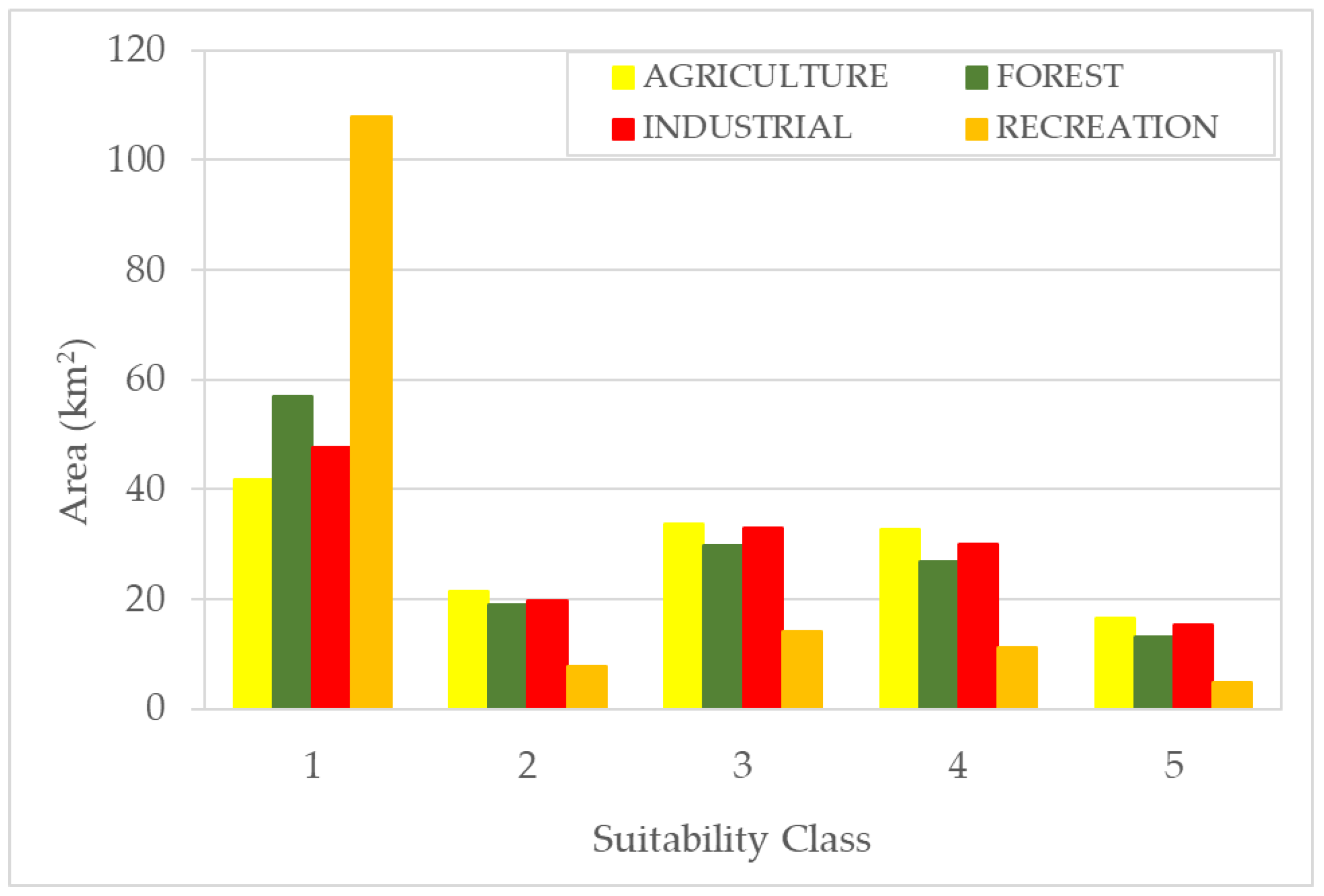
3. Results and Discussion

3.1. Determination of Criteria Weights

As each land use was derived from the spatial distribution of criteria and a qualitative assessment, each classification plays a specific role in its suitability for specific land use. For instance, agricultural land use is preferably developed on mild slopes. At the same time, the elevation criterion could be a restrictive factor if considering the kind of agriculture that would be developed. The spatial distribution of the selected criteria is depicted in Figure 3.
Each criterion is important for each land use, and a relationship among all should be quantified. For this, weights were attributed to each criterion based on the experts’ knowledge. The weights were multiplied by each raster using the Raster Calculator tool, generating 24 new weighted raster datasets, six for each land use. In turn, the resulting six raster datasets that had been produced for each land use were overlaid using the fuzzy overlay of the Spatial Analyst tool in the ArcGIS environment.
Slope surface is a very crucial criterion for the determination of land use suitability, and it was given priority in the weighting procedure regarding the other criteria. More specifically, mild slopes make the land more suitable for agricultural use, as they affect soil properties by reducing the soil layer when the slope angle increases and controlling soil erosion. For instance, the development of soils is delayed when the slope degree increases, and consequently, soil fertility decreases. Furthermore, with the increase in slope surface, land use development related to infrastructure development, such as recreational areas and industrial and photovoltaic parks, becomes difficult. Regarding forest land reclamation, steeper slopes are considered more favorable for tree development, as mild slopes are considered for other uses.
Elevation is a more flexible criterion for the mining area, meaning that at either high or low elevation, any one of the land uses would be attributed. Elevation could be a restrictive factor in a case where the agricultural land includes specific species that need special elevation conditions. However, within the boundaries of the research area, the elevation values did not have such a wide range in value. Considering the recreation parks and the human activities that could be developed there, the lower elevation could be a better choice for easier access to people there. Otherwise, industrial land use could be established at whatever elevation. Based on this approach, the highest elevation values were attributed to forest land use, as having the trees in the highest vicinity is aesthetically favorable.
The distance from roads plays a crucial role, especially in infrastructure development. More specifically, increasing the distance from roads decreases connection and convenience regarding the suitability for agricultural and industrial use. So, the highest values of suitability were assigned. The distance from rivers can attract anthropogenic activities, so the shortest distances were considered favorable for recreational and agricultural land use, while industrial use is preferable not to be developed close to rivers. For forest land use, a close distance to rivers was considered an advantage, as the presence of water favors tree development and ecosystem reservation. The distance from transmission lines was considered to favor only industrial development, as it decreases transportation expenses. However, longer distances are considered more favorable for other land uses. The distance from villages was evaluated as favorable to agricultural, forest, and recreational land uses, considering the easy access to farmlands and developing anthropogenic activities close to forests and recreational areas, respectively.
To obtain a quantitative aspect of the importance of each criterion regarding the already reclaimed areas, statistical correlation analysis among the already reclaimed areas and criteria classes was employed, and the results are presented in Table 1. The parameters with the strongest positive correlations show the most suitable classes that were selected for the forest and agricultural land use reclamation in the already reclaimed areas. In particular, the highest correlation was observed in the following range values per criterion: a slope of 17–30°, a distance from rivers of 1500–2226 m, a distance from roads of 0–400 m and from villages of 0–1650 m, an elevation of 800–924 m, and a distance from transmission lines of 1873–2635 m. These range values represent the conditions which were mostly considered during the already completed reclamation works. The respective range values for agricultural land reclamation were slopes of 0–2°, a distance from rivers of 1000–1500 m, a distance from roads of 400–900 m, a distance from villages of 0–1650 m, elevations of 800–924 m, and a distance from transmission lines of 1873–2635 m (Table 1).
Analyzing the selection of the criteria classes revealed that not all the criteria had the same importance considering land uses. In general, forest area development should not be strictly limited to steeper slopes. However, considering the mining area, the mildest slopes should have priority to be used for other purposes (e.g., agricultural and photovoltaic land). Usually, the steep slopes in a mining area are situated in the slope dumps and slope excavations for which geotechnical stability should be considered from the early beginning of mining operations, as well as for the reclamation stage. By reclaiming slopes with trees, geotechnical stability is generally amplified. The agricultural land use needs mild slopes for its growth and for people to cultivate agricultural areas. High elevations are not a restrictive criterion in either of the two scenarios.
Regarding the criterion “distance from rivers”, the high correlation value that was derived from the correlation analysis was attributed to the fact that the excavation and dumping works were employed in areas around the river. As a result, the reclamation works were unable to occur close to the river. However, in the post-mining land use planning framework, this criterion was selected with high distances as the most suitable only in the scenario of industrial reclamation.
Furthermore, forest development near roads or villages amplifies human contact with nature in forest land use scenarios. In agricultural scenarios, it is essential for people to cultivate their agricultural areas and have cultivated products directly available. The “distance from transmission lines” is a criterion that should be considered both in forest and agricultural development to prevent fire hazards. It is worth noting that the correlation results are a representation of the existing conditions due to the reclamation works and not strict values for which no deviation should exist.
The reclassification of the criteria regarding their suitability for agricultural and forest land use was determined based on the highest positive correlations. In some cases, the strongest correlation emerged for an intermediate criterion class. However, the general trend was considered.

3.2. Land Use Suitability Assessment

Figure 4 and Figure 5 depict the results of the overlay suitability analysis for each land use. The suitability analysis was employed initially for each land use separately by overlaying the selected criteria. Figure 4 depicts the spatial distribution of suitability classes graded from 1 to 5, representing the very-low-suitability pixels to the very-high-suitability pixels, respectively. In addition, the resulting suitability maps show that some areas are suitable for more than one land use, according to the evaluated criteria. From the histograms of Figure 5, it was observed that class 1, “very low suitability”, covered most of the area for all the land uses, while the next largest areas were classes 3, “moderate suitability”, and 4, “high suitability”. The “very high suitability” class did not exceed 2000 hectares in any of the cases and covered the least area in each land use. This fact was interpreted by the weights that were given during the overlay analysis of each criterion regarding each land use (Table 2). Priority was attributed to the slope criterion for all the investigated land uses because, according to the engineering judgment, it is the dominant characteristic in mining areas that is considered during reclamation.
Although four land use suitability maps were produced for specific land uses, the main target was the allocation of different land uses in the mining area, considering the highest suitability. For this, a further analysis was employed by overlaying the resulting four suitability maps of Figure 4. A weighted overlay of the four suitability maps was employed based on the weights that were attributed to each land use, according to the experts’ judgment (Table 2). The resulting map depicted a suitability distribution in the study area with values of a fuzzy scale from 0 to 0.19 without declaring the type of land use. To obtain information about the type of land use that covered each cell throughout the suitability distribution map, subtraction was employed among the raster datasets. More specifically, each of the four land use suitability maps in Figure 4 was subtracted from the suitability distribution map. The possible cases were two: zero values and other values different from zero. In the cells where the value was equal to zero, the specific subtracted land use covered the cells with zero values. The resulting new suitability map is depicted in Figure 6, where the red color depicts the industrial areas, including building infrastructure and photovoltaic parks, the orange depicts the recreation parks in rather smaller areas, and the yellow and green colors depict the agricultural and forest areas, respectively.
Simultaneously, some geospatial mining characteristics affect the final decision on the post-mining land uses. From the combination of the topographical criteria with the mining characteristics was derived the final post-mining land use allocation map. Figure 7 shows the spatial distribution of the additional characteristics, which were (a) undisturbed areas, (b) graded areas, (c) areas that currently host building and mining infrastructure (e.g., power plants), and (d) possible final pits. Based on these characteristics and their specifications, land repurposing was reconsidered to ensure a sustainable equilibrium for the area. More specifically, the undisturbed areas were considered for two basic types of land uses: (a) industrial, as it constitutes a more geotechnically suitable land for foundation compared with the disturbed areas, and (b) agricultural, as the topographical criteria favored this particular use in these sites. The graded areas constituted areas that were relatively mild, which were intended either for agricultural use or photovoltaics installation. In addition, the power plants and buildings are infrastructure that has already been founded in undisturbed areas and is considered crucial to be maintained in the current use in the context of the new productive–economical model, with the main target of supporting the photovoltaics industry and employment development. Considering the filling of mining voids as the most sustainable solution, three pit lakes are planned to be formulated in the future.
The mining characteristics were imported into the suitability algorithm as spatial information (shapefile) in the ArcGIS environment and considered spatial constraints in the suitability analysis. More specifically, from the evaluation of the mining characteristics based on the experts’ judgment, in combination with the physical ones, was derived the final suitability map of the post-mining land uses of Figure 8 with the respective areas of land uses in Table 3. As depicted in the map, the industrial land covered an important part of the area, including photovoltaic parks, buildings, infrastructure, and power plants. This was interpreted by the intention of the Just Transition to develop renewable energy sources and ensure sustainable industrial development with the simultaneous target of replacing traditional energy sources. However, the proportion of forest land in the total area was almost like in the industrial lands, which favored equilibrium maintenance. It was observed that the land use areas that were derived from the integration of the physical and mining characteristics were quite like the respective areas of the initial land use allocation model. Specifically, the industrial and agricultural land uses seemed to have very close acreage values. However, the spatial allocation was not the same. The differences in the spatial allocation were attributed to the incorporation of the experts’ judgment regarding the mining characteristics in the model. According to the knowledge management of the mining area and the experts’ judgment, the lake development in the deeper excavated levels of the area was a sustainable solution and constituted an important characteristic that did not exist in the initial model. As shown in Table 3, the difference among the forest land acreages was balanced in the final model by sharing this acreage in the lakes and recreation parks.
By comparing the suitability maps of Figure 6 and Figure 8, it could be concluded that topographic characteristics played an important role in spatial land use allocation, as most of the areas of Figure 8 were in common with those of Figure 6. However, the mining information was considered decisive for the final compilation of the land use suitability map. In particular, the lakes in Figure 8 are not depicted in Figure 6, as they were not imported into the topographical analysis, although they were planned to be formulated in the context of possible sustainable reclamation.

4. Conclusions

Through a geospatial analysis model, the mining land suitability to host post-mining land uses in the context of the mine closure procedures was investigated with an application to the Ptolemais surface lignite mines in northern Greece. Four possible scenarios of land uses were examined: forest, agricultural, industrial, and recreational parks. The algorithm was developed in an ArcGIS environment based on fuzzy logic principles to address the uncertainties accompanying the determination of suitability class thresholds. In this framework, six criteria were adopted concerning the local topographical characteristics of the study area and were combined with criteria related to specific mining characteristics. The criteria included slope, elevation, and distance criteria vis-à-vis villages, roads, rivers, and transmission lines, while the mining characteristics referred to the type of ground (undisturbed by mining operations or graded areas after exploitation), the existing infrastructure, and mine closure planning, emphasizing the final landscape of the mining area.
Several conclusions were derived concerning the previous studies that have been elaborated upon in this field. Methods such as AHP, MDCA, and TOPSIS, etc., focus on hierarchy, scoring, and rating systems. In particular, using the AHP method to attribute weights to suitability criteria reflects the mean preferences of the experts that do not fit all locations. In contrast, the methods applied in the context of the present research combine a mathematical model with the judgment of personnel occupied in the mines on a daily basis who have long-term professional experience. In addition, this combination is more reliable to the proposition of post-mining land uses and was adapted to the specifications of local mining conditions.
Considering that mining operations are dynamic processes and the respective mining areas are always susceptible to changes, it has been shown through the present research that the optimal land use selection for each land segment is a multi-dimensional problem and that mathematical models must be combined with industrial knowledge to produce more realistic results. Land use suitability evaluation plays an essential role in mining land reclamation, and the choice of evaluation methods affects, to a great extent, the accuracy of results and the objectivity of a decision. This fact, combined with the overall mining knowledge incorporated into the algorithm, constitutes the innovative contribution of the present work to the existing land use suitability approaches, and this method could be used as a useful, integrated approach to respective land use suitability issues.
In addition, the applied land use suitability analysis showed that the selected criteria constitute the key parameters that define the post-mining land uses, depending on their values, spatial distribution, and importance regarding each land use. The importance of the key parameters for each land use was configured using the mining experts’ judgment by attributing weights to each criterion. Furthermore, the evaluation of the results showed that the topographical–morphological criteria are the primary parameters that should be investigated to determine the land use suitability to make an initial estimation of the positioning for each land use. The integration of the additional mining criteria with the topographical–morphological ones was employed by importing spatial information into the developed suitability algorithm. Finally, it has been demonstrated that the incorporation of the experts’ judgment regarding the mining characteristics is of high importance, as these characteristics are related to specific mining conditions and, consequently, represent the necessities for the reclamation of the respective areas after exploitation, and they define the final suitability model.
In conclusion, the mining industry should always search for ways to combine production with sustainability principles. Furthermore, in the context of decarbonization and green energy production, the mining industry explores areas suitable for new industrial uses in combination with forest or agricultural areas and recreational parks to achieve a sustainable equilibrium in the broader mining region. Based on these principles, the land use allocation proposed for the Ptolemais post-mining area represents a targeted, new productive–economical model which aims to ensure the employment of the population and sustainable development after mine closure.

Author Contributions

Conceptualization, A.S., N.P., C.R. and F.P.; methodology, A.S., N.P., C.R. and F.P.; software, A.S. and N.P.; validation, A.S., N.P., C.R. and F.P.; formal analysis, A.S., N.P. and C.R.; investigation, A.S., N.P., C.R. and F.P.; resources, A.S., N.P. and C.R.; data curation, A.S., N.P., C.R. and F.P.; writing—original draft preparation, A.S. and N.P.; writing—review and editing, A.S., N.P., C.R. and F.P.; visualization, A.S. and N.P.; supervision, N.P. and C.R.; project administration, C.R. All authors have read and agreed to the published version of the manuscript.

Funding

This research received no external funding.

Institutional Review Board Statement

Not applicable.

Informed Consent Statement

Not applicable.

Data Availability Statement

The datsa used to support the findings of this study are available from the corresponding author upon reasonable request.

Conflicts of Interest

The authors declare no conflict of interest.

References

  1. Wang, X.; Lo, K. Just Transition: A Conceptual Review. Energy Res. Soc. Sci. 2021, 82, 102291. [Google Scholar] [CrossRef]
  2. Pavloudakis, F.; Karlopoulos, E.; Roumpos, C. Just Transition Governance to Avoid Socio-Economic Impacts of Lignite Phase-out: The Case of Western Macedonia, Greece. Extr. Ind. Soc. 2023, 14, 101248. [Google Scholar] [CrossRef]
  3. Kretschmann, J. Post-Mining—A Holistic Approach. Min. Metall. Explor. 2020, 37, 1401–1409. [Google Scholar] [CrossRef]
  4. Zervas, E.; Vatikiotis, L.; Gareiou, Z. Proposals for an Environmental and Social Just Transition for the Post-Lignite Era in Western Macedonia, Greece. IOP Conf. Ser. Earth Environ. Sci. 2021, 899, 012049. [Google Scholar] [CrossRef]
  5. Mborah, C.; Bansah, K.J.; Boateng, M.K. Evaluating Alternate Post-Mining Land-Uses: A Review. EP 2015, 5, 14. [Google Scholar] [CrossRef]
  6. Wang, S.; Liu, C.; Zhang, H. Suitability Evaluation for Land Reclamation in Mining Area: A Case Study of Gaoqiao Bauxite Mine. Trans. Nonferr. Met. Soc. China 2011, 21, s506–s515. [Google Scholar] [CrossRef]
  7. Kivinen, S. Sustainable Post-Mining Land Use: Are Closed Metal Mines Abandoned or Re-Used Space? Sustainability 2017, 9, 1705. [Google Scholar] [CrossRef]
  8. Amirshenava, S.; Osanloo, M. Strategic Planning of Post-Mining Land Uses: A Semi-Quantitative Approach Based on the SWOT Analysis and IE Matrix. Resour. Policy 2022, 76, 102585. [Google Scholar] [CrossRef]
  9. Scannell, Y. The Regulation of Mining and Mining Waste in the European Union. J. Energy Clim. Environ. 2012, 3, 177–268. [Google Scholar]
  10. Clark, A.; Clark, J.C. An International Overview of Legal Frameworks for Mine Closure. VIII. 2005. Available online: http://www.irdc.org (accessed on 12 August 2023).
  11. International Organization for Standardization. Environmental Management Systems—Requirements with Guidance for Use (ISO Standard No. 14001:2015). 2015. Available online: https://www.iso.org/standard/60857.html (accessed on 12 August 2023).
  12. International Organization for Standardization. Environmental Management Systems—General Guidelines on Implementation (ISO Standard No. 14004:2016). 2016. Available online: https://www.iso.org/standard/60856.html (accessed on 12 August 2023).
  13. International Organization for Standardization. Environmental Management—Environmental Assessment of Sites and Organizations (EASO). (ISO Standard No. 14015:2001). 2001. Available online: https://www.iso.org/standard/23164.html (accessed on 12 August 2023).
  14. International Organization for Standardization. Environmental Management—Guidelines for Establishing Good Practices for Combatting Land Degradation and Desertification—Part 1: Good Practices Framework. (ISO Standard No. 14055–1:2017). 2017. Available online: https://www.iso.org/standard/64646.html (accessed on 12 August 2023).
  15. Wolfhart, P.; Steiakakis, C. Repurposing Land and Assets for Western Macedonia; Presented at the European Commission, Ministry of Environment and Energy, the Governor of Western Macedonia and the Coal Regions in Transition Working Group for Western Macedonia; The World Bank: Washington, DC, USA, 2020. [Google Scholar]
  16. Beuermann, C. Environmental Rehabilitation and Repurposing, Guidance on the Governance of Environmental Rehabilitation and Repurposing in Coal Regions in Transition; Platform for Coal Regions in Transition; Wuppertal Institute: Wuppertal, Germany, 2020. [Google Scholar]
  17. Paraskevis, N.; Servou, A.; Roumpos, C.; Pavloudakis, F. Spatiotemporal Interactions between Surface Coal Mining and Land Cover and Use Changes. J. Sustain. Min. 2021, 20, 72–89. [Google Scholar] [CrossRef]
  18. He, T.; Zhang, M.; Guo, A.; Zhai, G.; Wu, C.; Xiao, W. A Novel Index Combining Temperature and Vegetation Conditions for Monitoring Surface Mining Disturbance Using Landsat Time Series. CATENA 2023, 229, 107235. [Google Scholar] [CrossRef]
  19. Karan, S.K.; Samadder, S.R.; Maiti, S.K. Assessment of the Capability of Remote Sensing and GIS Techniques for Monitoring Reclamation Success in Coal Mine Degraded Lands. J. Environ. Manag. 2016, 182, 272–283. [Google Scholar] [CrossRef]
  20. Spanidis, P.-M.; Roumpos, C.; Pavloudakis, F. A Methodology Combining IDEF0 and Weighted Risk Factor Analysis for the Strategic Planning of Mine Reclamation. Minerals 2022, 12, 713. [Google Scholar] [CrossRef]
  21. Holcombe, S.; Keenan, J. Mining as a Temporary Land Use Scoping Project: Transitions and Repurposing’. Centre for Social Responsibility in Mining; The University of Queensland: Brisbane, Australia, 2020. [Google Scholar]
  22. Mbedzi, M.D.; Van Der Poll, H.M.; Van Der Poll, J.A. Enhancing a Decision-Making Framework to Address Environmental Impacts of the South African Coalmining Industry. Energies 2020, 13, 4897. [Google Scholar] [CrossRef]
  23. Malczewski, J. GIS-Based Land-Use Suitability Analysis: A Critical Overview. Prog. Plan. 2004, 62, 3–65. [Google Scholar] [CrossRef]
  24. Mohamed, A.H.; Shendi, M.M.; Awadalla, A.A.; Mahmoud, A.G.; Semida, W.M. Land Suitability Modeling for Newly Reclaimed Area Using GIS-Based Multi-Criteria Decision Analysis. Environ. Monit. Assess 2019, 191, 535. [Google Scholar] [CrossRef] [PubMed]
  25. Soltanmohammadi, H.; Osanloo, M.; Aghajani Bazzazi, A. Deriving Preference Order of Post-Mining Land-Uses through MLSA Framework: Application of an Outranking Technique. Environ. Geol. 2009, 58, 877–888. [Google Scholar] [CrossRef]
  26. Soltanmohammadi, H.; Osanloo, M.; Aghajani Bazzazi, A. An Analytical Approach with a Reliable Logic and a Ranking Policy for Post-Mining Land-Use Determination. Land Use Policy 2010, 27, 364–372. [Google Scholar] [CrossRef]
  27. Morales, F.; de Vries, W. Establishment of Land Use Suitability Mapping Criteria Using Analytic Hierarchy Process (AHP) with Practitioners and Beneficiaries. Land 2021, 10, 235. [Google Scholar] [CrossRef]
  28. Yin, K.L.; Yan, T.Z. Statistical Prediction Model for Slope Instability of Metamorphosed Rocks. In Proceedings of the 5th International Symposium on Landslides, Lausanne, Switzerland, 10–15 July 1988; A.A. Balkema: Rotterdam, The Netherlands, 1988; Volume 2, pp. 1269–1272. [Google Scholar]
  29. Zabihi, H.; Alizadeh, M.; Kibet Langat, P.; Karami, M.; Shahabi, H.; Ahmad, A.; Nor Said, M.; Lee, S. GIS Multi-Criteria Analysis by Ordered Weighted Averaging (OWA): Toward an Integrated Citrus Management Strategy. Sustainability 2019, 11, 1009. [Google Scholar] [CrossRef]
  30. Memarbashi, E.; Azadi, H.; Barati, A.; Mohajeri, F.; Passel, S.; Witlox, F. Land-Use Suitability in Northeast Iran: Application of AHP-GIS Hybrid Model. IJGI 2017, 6, 396. [Google Scholar] [CrossRef]
  31. Cheng, L.; Sun, H. Reclamation Suitability Evaluation of Damaged Mined Land Based on the Integrated Index Method and the Difference-Product Method. Environ. Sci. Pollut. Res. 2019, 26, 13691–13701. [Google Scholar] [CrossRef]
  32. Santé-Riveira, I.; Crecente-Maseda, R.; Miranda-Barrós, D. GIS-Based Planning Support System for Rural Land-Use Allocation. Comput. Electron. Agric. 2008, 63, 257–273. [Google Scholar] [CrossRef]
  33. Carver, S.J. Integrating Multi-Criteria Evaluation with Geographical Information Systems. Int. J. Geogr. Inf. Syst. 1991, 5, 321–339. [Google Scholar] [CrossRef]
  34. Dalavi, P.; Rajagopal, J.; Chavare, S. Agricultural Land Suitability Analysis of Swetha River Basin. In Proceedings of the National Conference on Application of Geoinformatics in Rural, Urban & Climatic Studies, Indian Institute of Technology Bombay, Mumbai, India, 6–7 June 2014; Volume 2, pp. 92–100. [Google Scholar]
  35. Euracoal Coal Industry across Europe. Available online: https://euracoal.eu/info/country-profiles/greece/ (accessed on 12 August 2023).
  36. Public Power Corporation 2021 Sustainability Report. 2021. Available online: https://www.dei.gr/en/ppc-group/sustainable-development/sustainability-reports/sustainability-report-2021/ (accessed on 12 August 2023).
  37. ESRI Suitability Modelling-GIS Training 2021. Esri Academy. Available online: https://www.esri.com/training/catalog/6007454b6bf5b1688a23b581/suitability-modeling-introduction/ (accessed on 12 August 2023).
  38. Jenks, G.F. The Data Model Concept in Statistical Mapping. In International Yearbook of Cartography 7; Frenzel, K., Ed.; Bertelsmann: Gütersloh, Germany, 1967; pp. 186–190. [Google Scholar]
  39. McMaster, R. In Memoriam: George, F. Jenks (1916–1996). Cartogr. Geogr. Inf. Syst. 1997, 24, 56–59. [Google Scholar] [CrossRef]
  40. Van Westen, C.J. Statistical Landslide Hazard Analysis. In ILWIS 2.1 for Windows Application Guide; ITC Publication: Enschede, The Netherlands, 1997; pp. 73–84. [Google Scholar]
  41. Yalcin, A. GIS-Based Landslide Susceptibility Mapping Using Analytical Hierarchy Process and Bivariate Statistics in Ardesen (Turkey): Comparisons of Results and Confirmations. CATENA 2008, 72, 1–12. [Google Scholar] [CrossRef]
  42. Malczewski, J. GIS-based Multicriteria Decision Analysis: A Survey of the Literature. Int. J. Geogr. Inf. Sci. 2006, 20, 703–726. [Google Scholar] [CrossRef]
  43. Zadeh, L.A. Fuzzy Sets. Inf. Control 1965, 8, 338–353. [Google Scholar] [CrossRef]
Figure 1. Location map of the Ptolemais mining area (June 2023) (map in Greek Geodetic Reference System—GGRS87).
Sustainability 15 14388 g001
Figure 2. Pseudo-flowchart of the applied methodology.
Sustainability 15 14388 g002
Figure 3. Classification of the selected criteria (a) slope surface, (b) elevation, (c) distance from villages, (d) distance from rivers, (e) distance from roads, and (f) distance from transmission lines.
Sustainability 15 14388 g003aSustainability 15 14388 g003b
Figure 4. Suitability maps based on the six overlaid criteria.
Sustainability 15 14388 g004
Figure 5. Areas of suitability classes per land use.
Sustainability 15 14388 g005
Figure 6. Land use allocation based on the topographic criteria.
Sustainability 15 14388 g006
Figure 7. Spatial distribution of the additional parameters that were considered in the suitability model.
Sustainability 15 14388 g007
Figure 8. Final land use suitability map.
Sustainability 15 14388 g008
Table 1. Weighting values’ (Wi) distribution in the criteria classes.
CriteriaClass NumberClassWifWiag
Slope (°)10–2°−0.4150.247
22–6°0.1230.030
36–11°0.198−0.530
411–17°0.327−0.615
517–30°0.912−0.805
Elevation (m)1450–610−2.6230.000
2610–680−0.930−2.005
3680–7500.3610.722
4750–8000.5960.376
5800–9240.9120.902
Distance from roads (m)10–4000.238−0.528
2400–9000.1180.437
3900–1400−0.2630.212
41400–2000−0.769−0.326
52000–3539−0.553−0.229
Distance from villages (m)10–16500.3600.865
21650–28500.264−0.410
32850–40000.1930.096
44000–5000−0.0760.134
55000–6657−1.165−1.850
Distance from rivers (m)10–316−0.311−0.897
2316–6800.099−0.196
3680–10000.1650.375
41000–1500−0.0150.587
51500–22260.4270.427
Distance from transmission lines (m)10–539−0.044−0.749
2539–11750.019−0.655
31175–18730.069−0.039
41873–26350.0480.822
52635–4049−0.1560.455
Table 2. Relative importance of criteria (weights).
Land Use/CriteriaAgricultureForestIndustrialRecreational
Slope0.350.200.400.30
Elevation0.150.200.050.20
Roads0.150.150.100.15
Villages0.50.150.150.5
Rivers0.250.150.100.5
Transmission Lines0.50.150.200.25
Sum1111
Table 3. Areas of final post-mining land uses and their proportions.
Land UseAreainitial 1
(km2)
Areafinal 2
(km2)
Proportioninitial 3
(%)
Proportionfinal 4
(%)
Lake_7.7_5.2
Recreational Parks12.114.68.29.9
Industrial5151.234.334.6
Agricultural28.629.919.320.2
Forest56.344.638.130.1
Total148148100100
1 Land use areas based on the physical characteristics, 2 land use areas based on the integration of physical and mining characteristics, 3 percentage of a land use area based on the physical characteristics within the Environmental Permitting Limit, 4 percentage of a land use area based on the integration of physical and mining characteristics within the Environmental Permitting Limit.
Disclaimer/Publisher’s Note: The statements, opinions and data contained in all publications are solely those of the individual author(s) and contributor(s) and not of MDPI and/or the editor(s). MDPI and/or the editor(s) disclaim responsibility for any injury to people or property resulting from any ideas, methods, instructions or products referred to in the content.

