Article

Characterization and Resource Potential of Li in the Clay Minerals of Mahai Salt Lake in the Qaidam Basin, China

1
Qinghai Bureau of Geology and Mineral Exploration and Development, Xining 810008, China
2
The Fourth Geological Exploration Institute of Qinghai Province, Xining 810008, China
3
Qinghai Key Laboratory of Shale Gas Resources, Xining 810001, China
4
State Key Laboratory of Loess and Quaternary Geology, Institute of Earth Environment, Chinese Academy of Sciences, Xi’an 710061, China
5
Academy of Plateau Science and Sustainability, Qinghai Normal University, Xining 810016, China
6
Qinghai Zhanyuan Geological Exploration Co., Ltd., Xining 810008, China
*
Authors to whom correspondence should be addressed.
Sustainability 2023, 15(19), 14067; https://doi.org/10.3390/su151914067
Submission received: 17 August 2023 / Revised: 18 September 2023 / Accepted: 19 September 2023 / Published: 22 September 2023
(This article belongs to the Special Issue Circular Economy and Mining Ecology Management)

Abstract

:
The strategic importance of lithium in global development has become increasingly prominent due to the rapid growth of the new energy automotive industry and the continuous advancements in controllable nuclear fusion technology. Lithium minerals in salt lakes possess advantageous characteristics, such as abundant reserves, environmental sustainability, and economic viability. Furthermore, with ongoing improvements in the lithium extraction process, the availability of lithium minerals in salt lakes is expected to further increase. The Qaidam Basin Salt Lake in China has served as the location for the establishment of numerous lithium carbonate production enterprises, resulting in a lithium carbonate production volume of 7 × 10⁴ t/yr in 2022. How to meet the growing need for lithium resources has become an enterprise focus. Nevertheless, there are large amounts of clay minerals in and around the bottom and periphery of the salt lake in the Qaidam Basin, and whether these minerals are of exploitable value, regardless of the state of the occurrence of lithium resources, remains unexplored. To ascertain the attributes, extent, and distribution of the lithium occurrence within the clayey layer of the Qaidam Basin, as well as to assess its resource potential, a total of 87 drill holes were conducted within a designated area of the Mahai Basin, which is a secondary basin in the Qaidam Basin. The subsequent analysis encompassed the examination of the lithium content within the clay minerals, the mineral composition of the clay, and, ultimately, the evaluation of the resource potential within the region. Compared with Quaternary salt lake deposits, brine deposits in gravel pores, and the Paleogene–Neogene Li-bearing salt deposits that have been studied, it is suggested that this is a novel form of a clay-type sedimentary Li deposit within the Qaidam Basin. The findings of this research will serve as a fundamental basis for future endeavors pertaining to the exploration and exploitation of lithium deposits within salt lake areas.

1. Introduction

The development of safe energy in coordination with the environment is an issue of common concern to all human beings [1]. With the gradual progression toward peak carbon emissions and carbon neutralization by major global powers, lithium has played a key role in important low-carbon technology products, such as power batteries and energy storage, and it has become a core component in the development of new energy and metal resources [2,3]. With the rapid development of the new energy automotive industry and continuous breakthroughs in the research and development of controllable nuclear fusion technology, the significance of Li in global development is increasingly being highlighted, and its strategic position continues to improve [4]. Hence, Li is known as “white oil”, an “energy metal”, or a “high-energy metal” [5,6,7]. At the same time, lithium series products are also widely used in industries such as smelting, refrigeration, atomic energy, aerospace and ceramics, glass, lubricants, rubber, welding, pharmaceuticals, and batteries. Globally, the distribution of lithium resources is abundant and highly concentrated, with 73% of lithium resources distributed in North and South America, whereas Li is relatively rare in Oceania, Asia, Europe, and Africa, accounting for 8%, 7%, 7%, and 5%, respectively. Most of the known lithium minerals are found in coarsely crystalline granites known as lithium–cesium–tantalum (LCT) pegmatites. In terms of lithium resources, the most important minerals are spodumene and petalite (both lithium aluminum silicates) and pink mica lepidolite (a potassium lithium aluminum silicate). Global lithium minerals can be mainly divided into three types: brine, hard rock, and clay [7]. Among them, the brine type can be subdivided into a salt lake type and a subsurface brine type. Salt lakes, hard rock, subsurface brine, and clay lithium minerals account for 58%, 26%, 6%, and 10% of global lithium resources, respectively [8,9,10]. China is rich in lithium brine resources, with these lithium reserves ranking third in the world behind those of Bolivia and Chile and accounting for approximately 30% of the world reserves. This lithium is mainly distributed in the Qaidam Basin on the Qinghai-Tibet Plateau and in Zabuye Lake in Tibet. Among these reserves, the lithium brine deposits in the Qaidam Basin are very rich, with large reserves, high grades, and great potential economic value [11]. In recent years, a breakthrough in lithium extraction technology for salt lakes with higher Mg/Li ratios has resulted in the development of several lithium carbonate producers in the Qaidam Basin Salt Lake, and in 2022, the production volume of lithium carbonate reached 7 × 10⁴ t/yr, which has strongly supported the development of new energy vehicles [11]. According to the related development plan of the Qinghai Salt Lake industry and other enterprises, and in accordance with the headline stating that “Qinghai Province has accelerated the promotion of the world class salt lake industry base construction to promote the high-quality development of the salt lake industry”, by the end of 2025, it is anticipated that Qinghai Salt Lake will achieve a lithium extraction capacity ranging from 20 × 104 to 25 × 104 t/yr. Given the substantial demand for lithium, ensuring the future provision of lithium resources stands as the foremost priority for corporations.
Research on lithium resources in the Qaidam Basin has primarily concentrated on contemporary salt lake deposits, halide deposits with gritty pores, and salt deposits from the Paleozoic to Cenozoic eras. Notably, halide and solid salt deposits have been the primary focuses of investigations [12,13,14]. However, there has been limited scholarly investigation into the extensively developed clay layers, which have been predominantly regarded as either rock formations containing salt minerals or interbedded layers containing dissolved minerals. Nevertheless, a recent study that specifically analyzed lithium contents examined three clay minerals within a clay layer in the Mahai Basin, which is a secondary basin in the Qaidam Basin [15]. The findings revealed that the lithium content not only exceeded that of the solid salt layer in the Mahai Basin but also surpassed the geochemical value in background rocks in the regional hard rock area, suggesting a notable enrichment of lithium within the clay layer of the Qaidam Basin.
To identify the characteristics of Li occurrence, its distribution range, and its distribution within the clayey layer of the Mahai Basin, as well as to assess its resource potential, a total of 87 holes were drilled within the designated study area. Subsequently, an analysis was conducted on the lithium contents present in the clay minerals and the mineral composition of the clay, and, ultimately, an evaluation of the resource potential within the area was performed. The outcomes of this research endeavor will serve as a fundamental basis for future endeavors in the exploration and assessment of lithium deposits within salt lakes.

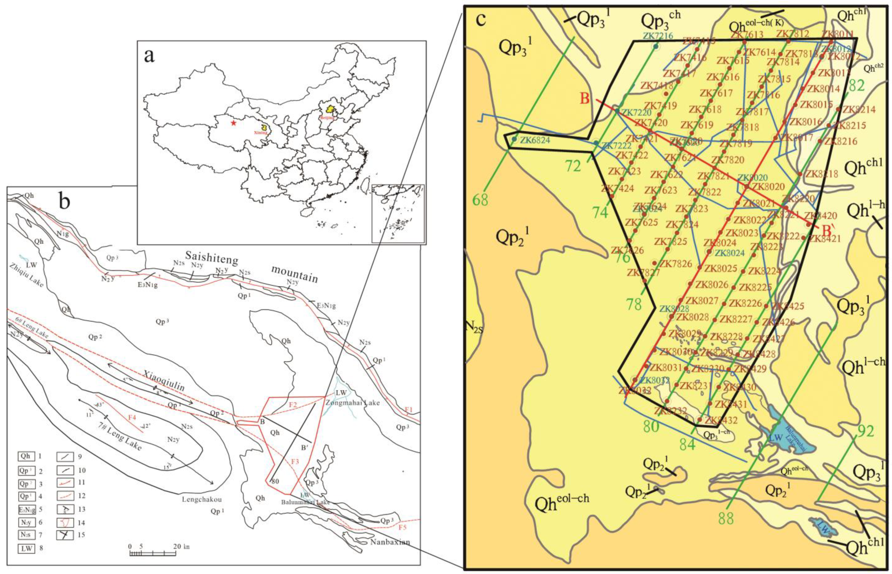
2. Geological Setting and Samples

The Mahai Basin, situated in the western portion of the eastern settlement zone of the Qaidam Basin, is a secondary basin that has been shaped by the development of fold and fracture structures (Figure 1). The mining area, which is a narrow enclosed basin oriented approximately NW-SE, spans a length of approximately 100 km and has a width of 20–35 km. The region primarily consists of a dry salt beach and encompasses a salt-forming area measuring 843 km2. The topography of the mining area is predominantly low in the north and south while it is elevated in the west and east, with elevations ranging from 2740–2747 m and a relative height difference of 7 m, indicating a flat topography. The southeastern portion of the mining area exhibits the least extensive distribution of modern lake marshes within the basin. It is situated adjacent to both the floodplain and the Saishiteng Mountains. Additionally, cold lakes IV and V on the western side serve as physical barriers, effectively separating the Mahai and Kunteyi Basins. On the southern side, there exists a zone with a residual mound resulting from subsidence, which was formed by the third and fourth early-to-late Pleistocene systems. To the east of the mining area, one can find Dezongma Lake and Balunma Lake. Furthermore, the Niulangzhinv Lake group, characterized by a star-like distribution, is located to the northwest [16,17,18].
The Mahai Basin exhibits a wide distribution of deposits ranging from the lower Pleistocene to the Holocene in age (Qp1–Qh). The lower Pleistocene strata (Qp1) are characterized by lacustrine clastic deposits, while the middle Pleistocene strata (Qp2) consist primarily of clay and silt, with subsequent rock salt deposits in a lacustrine chemical sedimentary layer. The upper Pleistocene strata (Qp3) are predominantly composed of clastic layers and lacustrine chemical deposits. The Holocene strata are primarily characterized by chemical sediments. The deposition of salt in the basin was accompanied by the deposition of clastic layers, specifically, clay and silt layers. In the same sedimentary environment, the salt minerals and clay layers in the basin have the same sedimentary facies. Clay layers are widely developed in the Holocene (Qh), upper Pleistocene (Qp3), middle Pleistocene (Qp2), and lower Pleistocene (Qp1) deposits. In the early Pliocene (N2) and lower Pleistocene (Qp1) deposits, after strong neotectonic uplift, the Mahai area changed from a broad alluvial plain to a semiclosed lake basin in which nearly 300-m-thick Quaternary lacustrine clastic deposits and chemical deposits formed. Thicker alluvial facies clastic deposits were formed in the surrounding areas, such as at the front of Saishiteng Mountain. The structure within the basin is relatively simple, with the northern strata being monoclinic and dipping southwestward while the southern strata are broadly and gently folded and generally dip northwestward, forming the synclinal structural characteristics of the salt lake basin. From the basin outward, the sequence of strata is as follows: Qh → Qp3 → Qp2 → Qp1. According to the results of the seismic data interpretation, there are several large NW-trending fault zones in the southwest of the basin, ranging from tens of kilometers to hundreds of kilometers in length. The F2 fault zone and F3 fault zone are the two main fault structural zones in the area, forming the main body of the Balumahai Salt Lake Basin. The sedimentary characteristics, ore body characteristics, rock salt, potassium salt, and brine of the Quaternary strata in the area are also basically controlled by these two fault zones, especially the brine deposits, which are clearly controlled by the fault zones [19,20]. Moreover, these fault zones serve as conduits for water flow and regulate the concentration of lithium in the Quaternary clay, contributing to its enrichment. To achieve a comprehensive understanding of the concentration of lithium minerals in the clay within the specified region, a total of 87 drill holes were strategically positioned throughout the study area. The drilling plan involved the establishment of a grid pattern, with 80 longitudinal sections and the primary exploration line designated B-B′ in the cross-section. The sampling drilling was conducted at intervals of 1 km within a network degree of 1 km, with a line distance of 2 km and a hole distance of 1 km. The drilling depth was determined as the lower boundary, adhering to an elevation of 2711.00 m, as authorized by the mining certificate (Figure 1).

3. Analytical Methods

3.1. Lithium Content Determination

An experiment was conducted to collect drilling samples for analysis. The samples were obtained at lengths of 0.5 m, 1.0 m, and 1.5 m, and the concentrations of Li in the samples did not exhibit significant variations. During the process, the lengths of the samples in the clay layer were all determined to be 1 m. Subsequently, the samples were dried in an oven and then pulverized to a particle size of <0.075 mm in an agate mortar. Approximately 20–50 mg of each powdered sample was carefully weighed and transferred into a 15 mL Teflon microwave digestion vessel. Following this, 4 mL of HNO3 and 1 mL of HF were added. The digestion of the samples was carried out using an UltraClave microwave digestion system (Milestone, Italy). Finally, the lithium content was analyzed using inductively coupled plasma-mass spectrometry (PE NexION 300D ICP-MS, PerkinElmer, USA) at the Institute of Earth Environment, Chinese Academy of Sciences.

3.2. Mineral Composition Analysis

The mineralogical compositions of the crystal structures of the samples were characterized by X-ray powder diffractometry (XRD). The XRD tests were conducted on the entire samples, as well as on the water-soluble matter and clay minerals of the samples. Three typical samples were selected: grayish brown clay (a), black mud (b), and grayish green clay (c). The mineral compositions of the samples were investigated through X-ray diffraction analysis. Prior to the analyses, each sample was dried at a temperature of 90 °C and manually ground to a particle size of −200 mesh using an agate mortar. The measurements and data collection were conducted using an Ultima IV X-ray diffractometer from Japan (test conditions: current: 40 mA, voltage: 40 kV, CuK with α radiation and a scanning angle (2 θ) of 5°~70°, and scanning speed: 2°/min), and the data analysis was performed using the XRD data universal analysis software (MDIJade 6.5) [21].
To comprehensively ascertain the clay mineral compositions in the samples, three types of sheets were prepared: naturally oriented sheets, ethylene glycol-saturated sheets, and high-temperature sheets.
The naturally oriented sheet, referred to as the N sheet, was obtained by centrifuging uniformly dispersed clay minerals on a frosted glass sheet with a surface area of 2.6 × 3.7 cm. Subsequently, the N sheet was allowed to air dry naturally, and the resulting film was subjected to analysis using a diffractometer.
For the ethylene glycol-saturated sheet (the EG sheet), the tested naturally oriented sheet was placed in ethylene glycol vapor for the saturation treatment. The ethylene glycol atmosphere was kept at 60 °C for at least 8 h. The obtained ethylene glycol-saturated sheet was then analyzed with a diffractometer.
For the high-temperature sheet (the T sheet), the tested ethylene glycol-saturated sheet was heated to 500 °C for 2.5 h and then left to cool to room temperature. The obtained high-temperature sheet was analyzed with a diffractometer.

4. Results and Discussion

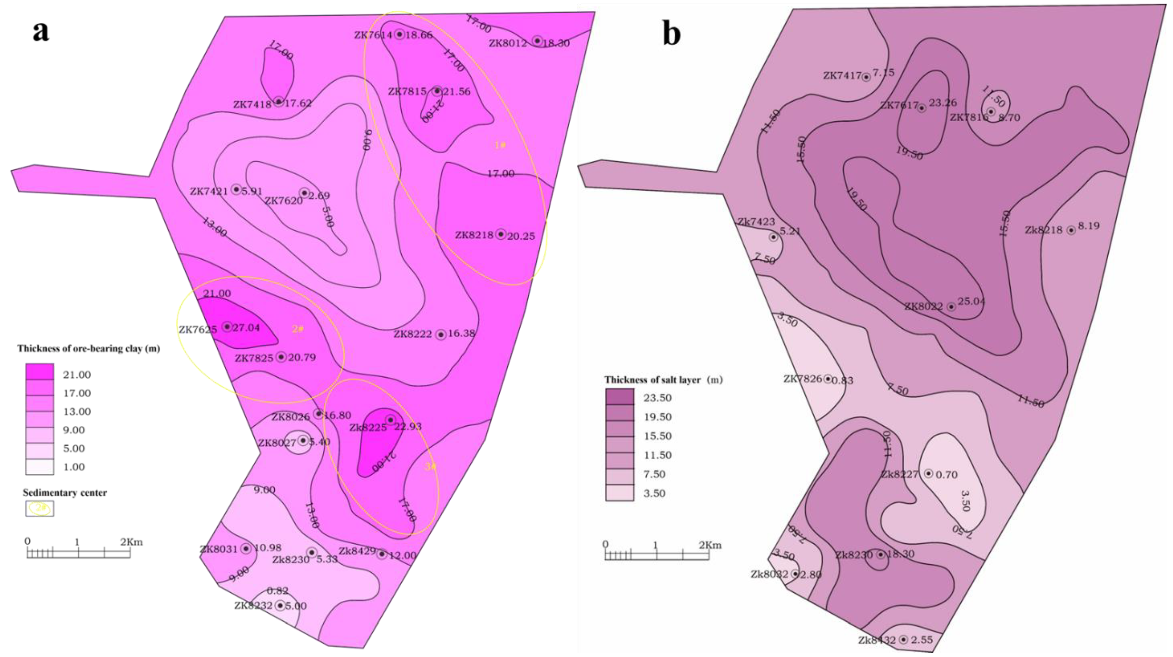
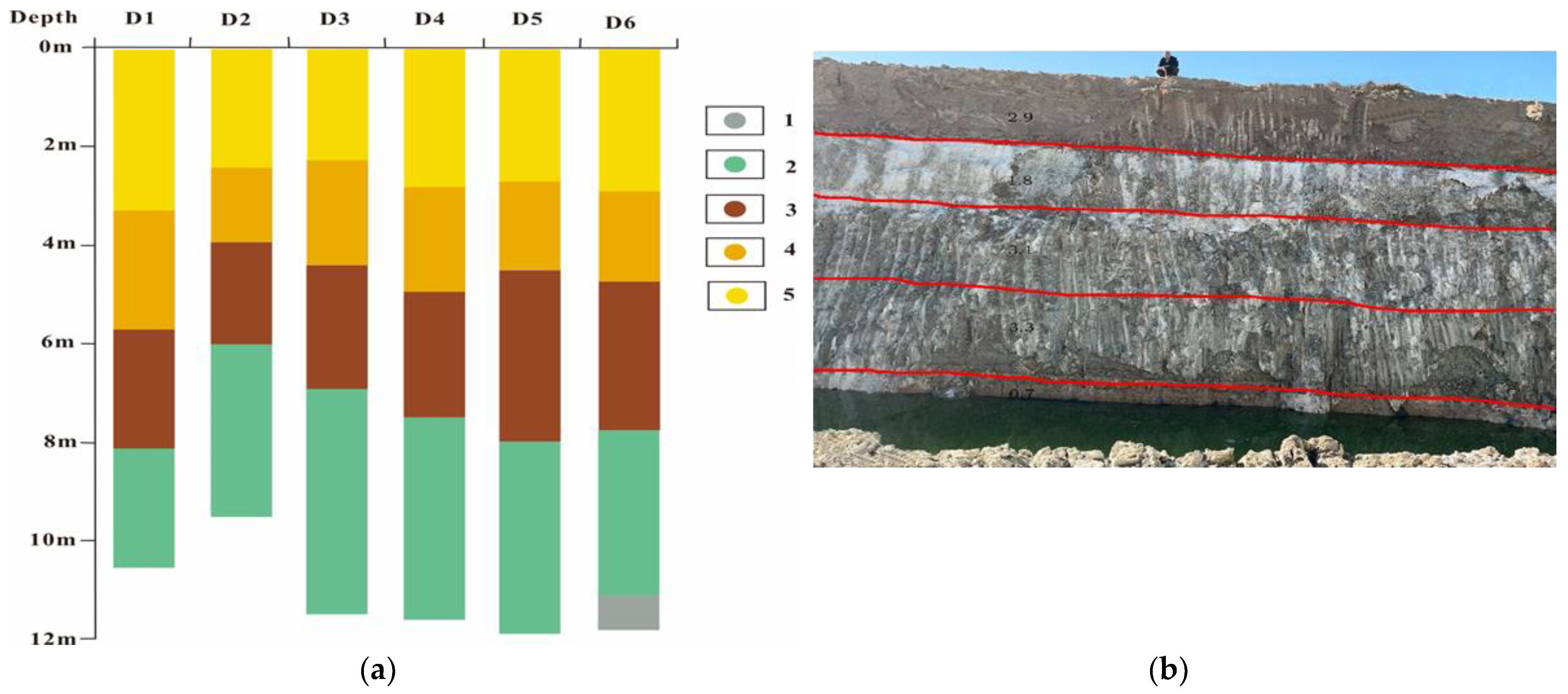
4.1. Spatial Distribution Characteristics of the Mineral Clay Layer

The spatial arrangement of the clay layer containing minerals is influenced by the sedimentary conditions of the original lake, and there exists a correlation between the salt layer and the clay layer. In regions where the salt layer is present, the clay layer tends to be thin, whereas in regions where the clay layer is present, the salt layer is absent. The distribution of clay layers is governed by the subsidence center, with the salt layer positioned above the clay layer. According to the examination of the contour maps depicting the salt layer and the ore-bearing clay layer, it could be observed that the evaluation area encompassed three sedimentary centers for clay layers, arranged in a north-to-south orientation, specifically, in a NW–WNW direction. Furthermore, it was evident that the thickness of the ore-bearing clay diminished progressively from the central regions toward the periphery (Figure 2).

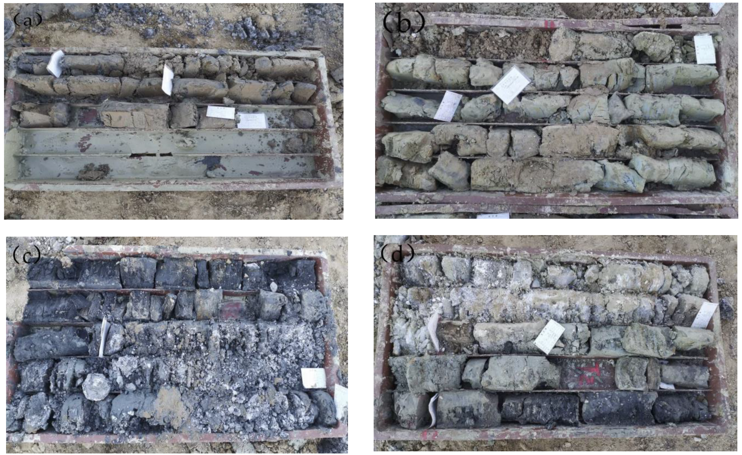
4.2. Vertical Distribution Characteristics of the Clay Layer

In the central region of the basin where subsidence occurs, the thickness of the clay layer containing minerals remains relatively constant, and the vertical arrangement of this clay layer is clearly distinguishable. To visually represent the distribution of the clay layer, we chose six representative brine transport channels for presentation. These channels can be roughly categorized from top to bottom as sedimentary cycles consisting of silt with salt, salt with silt, gray-brown clay, gray-green clay, clay with black carbon, and salt. Notably, as the subsidence center migrates, localized areas may exhibit intermittent occurrences of salt and sand layers between the stable clay layers (Figure 3).

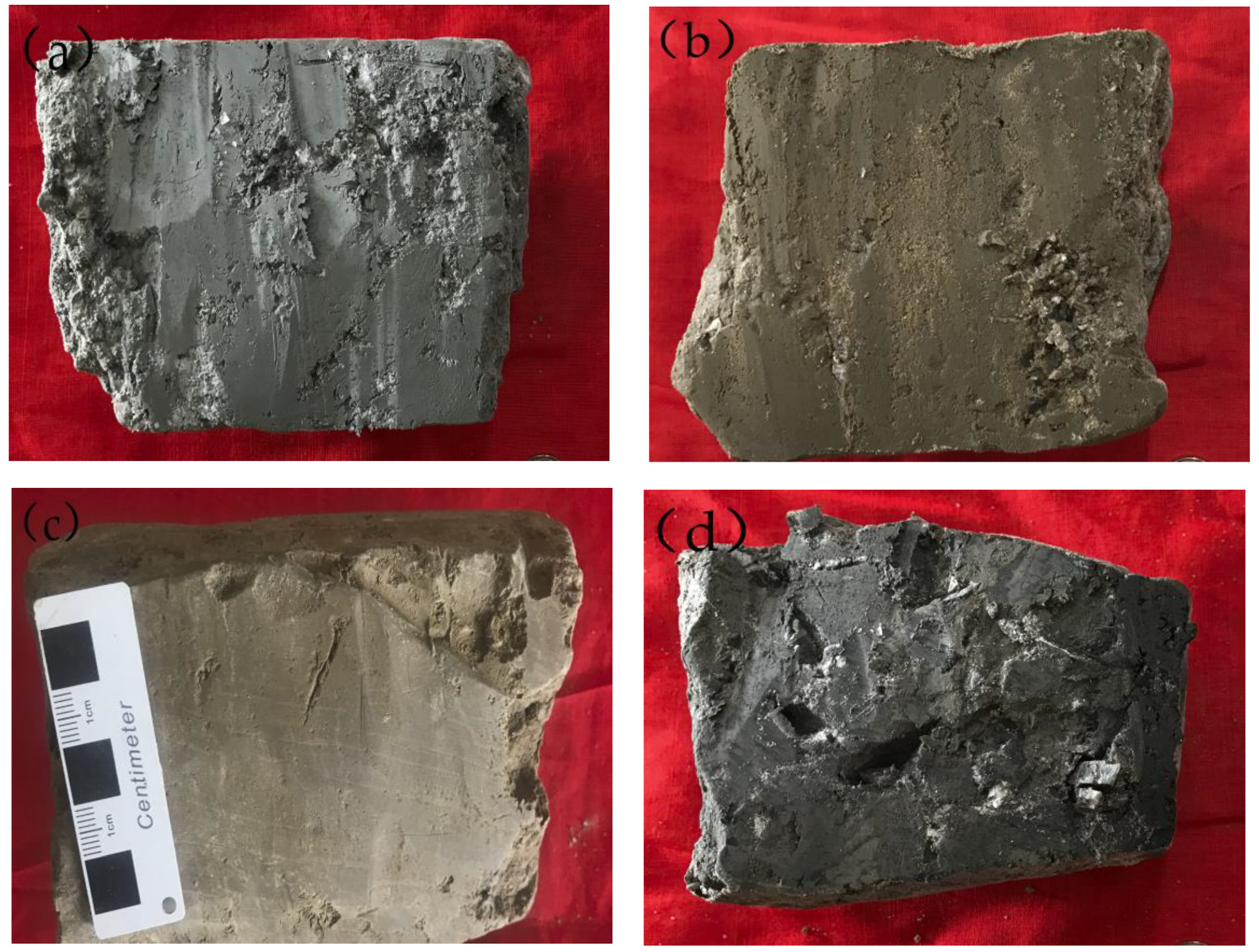
4.3. Degree of Development and Characteristics of the Clay Layer

Based on the findings from drilling, the clay present in this region could be categorized into three distinct types: grayish brown clay, grayish green clay, and black clay, based on their respective sedimentary environments (Figure 4). In addition, considering their different material compositions, the clay could be classified into categories such as silt-containing clay, gypsum-containing clay, salt-containing clay, and carbon-containing clay (Figure 5).
(1)
Classification based on the sedimentary environment
Figure 4. Differently colored clay layers in the evaluation area: (a) grayish brown clay; (b) grayish green clay; (c) black mud; and (d) grayish brown clay plus black mud.
Sustainability 15 14067 g004
(1) Gray-brown clay
Gray-brown clay was ubiquitously distributed throughout the entirety of the study area, as evidenced by its presence in all 87 drill holes. In the northern section of the northwestern 74 line within the study area, the observed thickness of the clay exceeded 10 m at the midpoint of the 78–84 line. Vertically, this clay was encountered within the Holocene, upper Pleistocene, and middle Pleistocene series, with a depth range spanning from 0 to 44.77 m. The ore layers predominantly exhibited a layered or quasilayered structure. The thicknesses of the ore layer within individual drill holes varied from 0.72 to 22.35 m, with an average thickness of 10.196 m. The gray-brown clay combinations found mainly included gray-brown clay containing gypsum, gray-brown clay containing silt, gray-brown clay containing salt, gray-brown clay, etc.
(2) Gray-green clay
A total of 64 holes were drilled within the entire area that contained gray-green clay. These holes were primarily located in the central northern part of the northeast 76–84 line of the working area, as well as the southern part of the southwest 76–84 line of the working area. The depths of the vertical distributions of the clay ranged from 0.75 m to 36.1 m, and it was predominantly found in the Holocene and upper Pleistocene series. The ore layers exhibited mostly layered or quasilayered structures as gray-brown clay. The thicknesses of the ore layer in each individual hole varied from 0.54 to 10.1 m, with an average thickness of 4.14 m. The drill-hole combinations mainly consisted of gray-green clay containing gypsum, gray-green clay containing silt, and gray-green clay containing salt.
(3) Black mud
A total of 38 black-mud-containing holes were drilled across the entire area, primarily concentrated in the northern part of the northeast 76–82 line of the working area and the central part of the working area along the 74–84 line (specifically, 25–26 holes). The vertical distribution depth ranged from 0.45 to 42.1 m, with this particular unit predominantly found in the Holocene and upper Pleistocene series. The ore layers exhibited a predominantly layered or quasilayered structure. In individual holes, the thickness of the ore layer varied from 0.51 to 10.95 m, with an average thickness of 4.06 m. The black mud combinations found mainly included silt containing rock salt, silt, gypsum containing silt, black silt, etc.
(2)
Classification based on the material composition
Figure 5. Clay layers of different compositions in the evaluation area: (a) clay with gypsum; (b) clay with silt; (c) clay with salt; and (d) black mud.
Sustainability 15 14067 g005
(1) Clay with gypsum
A total of 70 drill holes contained gypsum-bearing clay in the entire area, and they were primarily located in the northeast and central regions of the working area. These holes had vertical distribution depths ranging from 2.1 to 35.1 m. This unit was predominantly observed in the upper Pleistocene and middle Pleistocene series, and the ore layers were typically stratified or quasistratified. The thicknesses of the ore layer within each individual hole varied from 0.76 to 20.92 m, with an average thickness of 7.69 m. The clay compositions primarily consisted of clay with gypsum, clay with fine-grained gypsum, clay with gypsum rock salt, and clay with gypsum sludge.
(2) Clay with silt
A total of 67 of the drill holes within the entire area contained clay with silt. These holes were primarily located in the northwestern and southeastern regions of the working area and had depths of vertical distribution ranging from 3.4 to 40.3 m. Clay with silt was predominantly found in the upper Pleistocene and middle Pleistocene series, and the ore layers were typically layered or quasilayered. The thicknesses of the ore layer within each individual hole varied from 0.82 to 17.68 m, with an average thickness of 6.38 m. The clay compositions primarily consisted of gray-brown clay with silt, gray-green clay with silt, clay with silt, and silty clay.
(3) Clay with salt
A total of 44 of the drilling holes in the designated area contained clay with salt. These holes were primarily located in the northeastern and southwestern regions of the working area. The ZK7625 and ZK8020 boreholes exhibited the highest observed thickness of clay-containing salt, with depths of vertical distribution ranging from 0 to 38.1 m. This particular geological unit was predominantly found in the Holocene, upper Pleistocene, and middle Pleistocene series, and the ore layers within it were typically stratified or quasilayered. The thicknesses of the ore layer in each individual hole varied from 0.7 to 22.8 m, with an average thickness of 4.56 m. The clay compositions primarily included gray-brown clay with salt, gray-green clay with salt, clay with gypsum salt, and clay with silty salt.
(4) Black mud
The distribution characteristics of black mud, the types of ore combinations, and the description of black mud are important in the classification of sedimentary environments.

4.4. Geochemical Characteristics of the Li Contents

The present study examined the variations in the Li contents in the mineral-bearing clay layers of the study area. The mineral clay in the region is categorized into grayish brown clay, grayish green clay, black carbon clay, silty clay, gypsum clay, and salt clay. By comparing the classified ore-bearing clay with the analytical results of the entire area, as well as the analytical results of the silt layer and the salt layer, it was found that the Li contents in sedimentary layers exhibited a positive correlation with the clay content. Specifically, a higher clay content corresponded to a greater Li concentration. The general trend exhibited elevated concentrations in the northern and eastern regions, while lower concentrations were observed in the southern and western areas, aligning with the distribution of the clay thickness.
Table 1 presents the following distinctive features of the Li content variations:
(1)
The salt layer in the evaluation area exhibited the lowest Li contents, followed by the silty clay layers. A clear correlation was observed between the enrichment of Li and the clay content in the study area, as evidenced by the association between higher clay contents and greater Li enrichment.
(2)
Despite variations in the sedimentary environments, the Li contents remained stable in the gray-brown clay, gray-green clay, and black mud, with a small coefficient of variation. The average Li2O contents ranged from approximately 114.34 μg/g to 123.94 μg/g, with a coefficient of variation of 4.21%.
(3)
Among the different material compositions, the Li contents remained stable, exhibiting a small coefficient of variation in the clay with silt, gypsum, salt, and black mud. Among them, the average Li2O contents ranged from 117.85 μg/g to 124.59 μg/g, with a coefficient of variation of 2.97%.
(4)
According to the average Li content in the specified region, the overall average clay value, and the presence of seven distinct clay types (grayish brown, grayish green, black carbon-bearing, silt-bearing, gypsum-bearing, and salt-bearing), the Li contents in the clay-containing minerals exhibited a consistent and minimal coefficient of change. The average Li2O contents ranged from 114.34 μg/g to 124.59 μg/g, with a coefficient of variation of 4.76%.
In conclusion, when considering the sedimentary environment, various components, and the overall average value, the Li contents in this area exhibited consistent fluctuations with a minimal coefficient of variation, indicating significant prospects for mineral exploration and exploitation. The gray-brown clay, gray-green clay, and black mud were the indicative layers during prospecting.

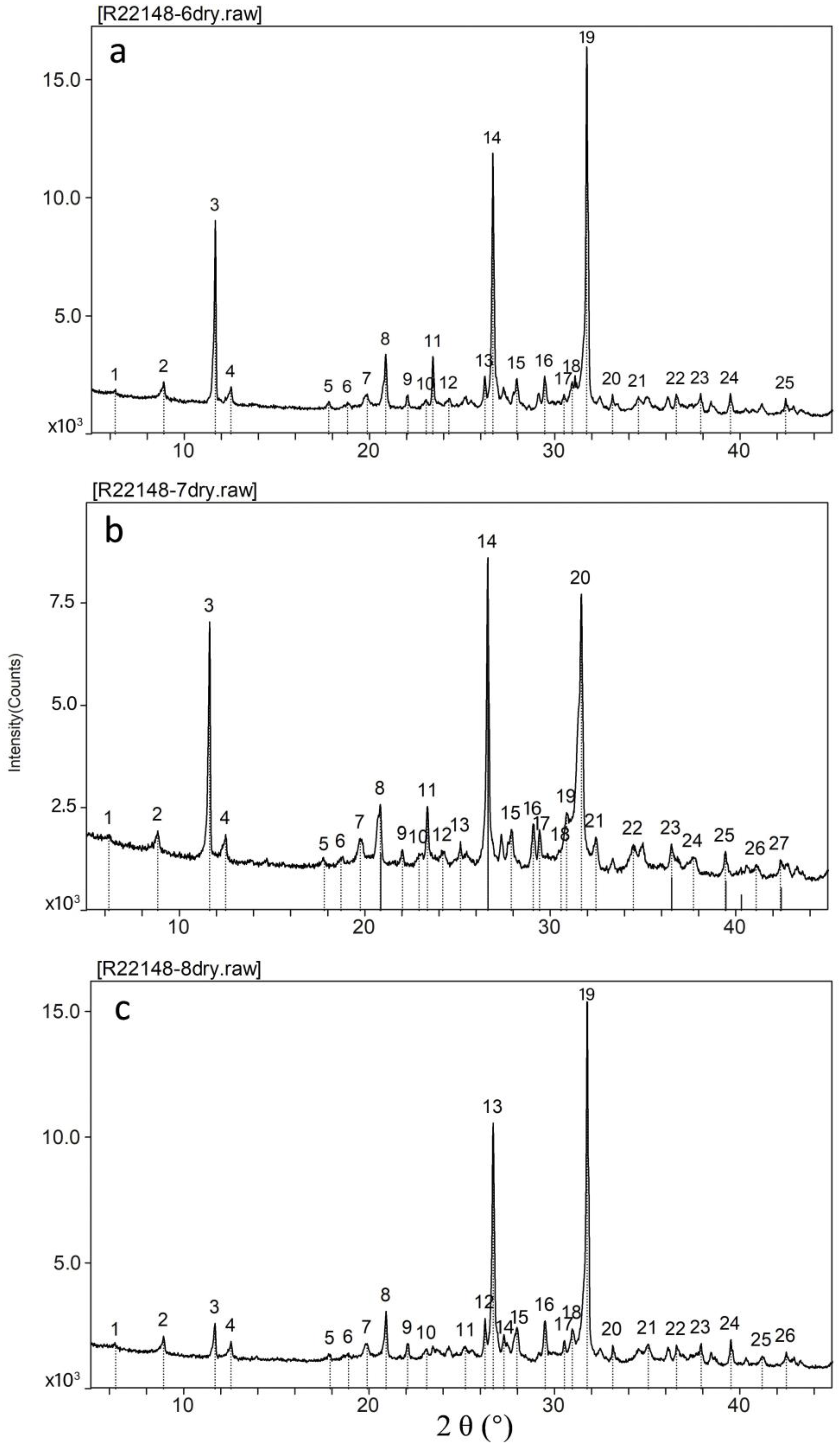
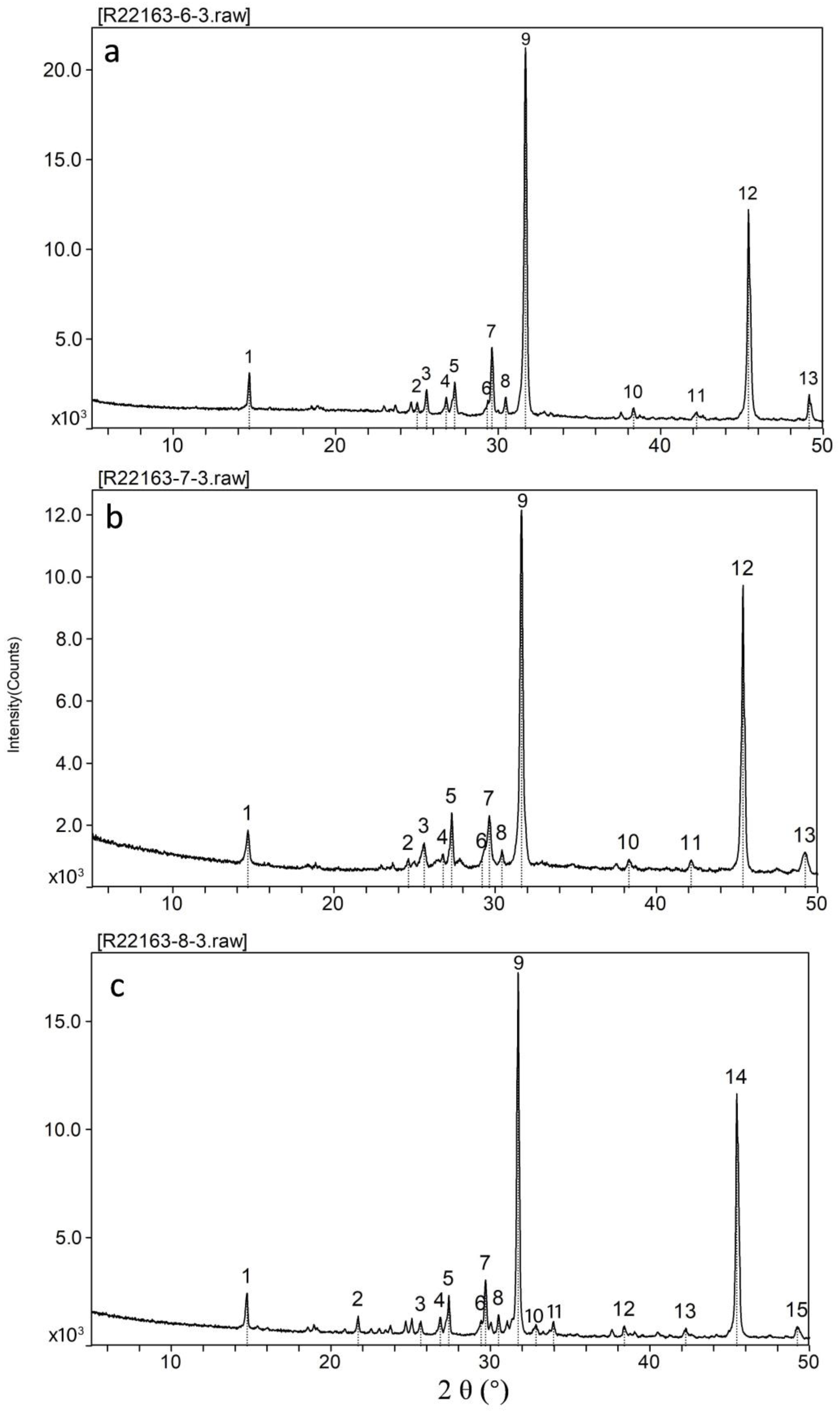
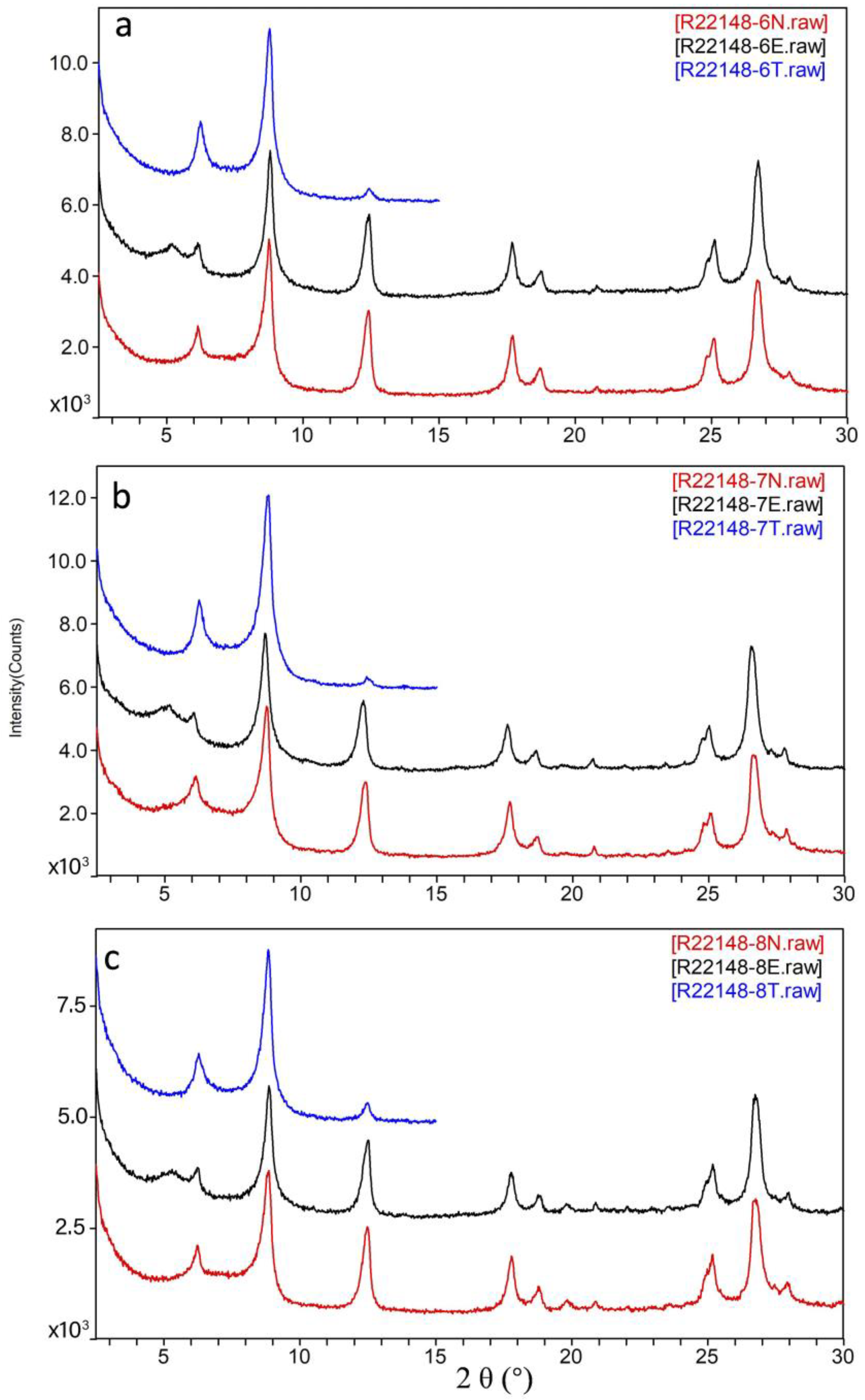
4.5. Mineral Composition

4.5.1. Mineral Compositions of Entire Samples

The X-ray diffraction analysis spectra of three representative samples are presented in Figure 6. Based on the XRD data, it was initially determined that the main mineral components of the samples included quartz, plagioclase, pyrite, carbonate minerals (calcite, aragonite, and dolomite), illite, chlorite, kaolinite, mixed-layer clay, salt minerals, gypsum, and carnallite. Based on semiquantitative calculations, the primary compositions and contents are presented in Table 2.
The data presented in the table indicated that silicon-containing minerals constituted approximately 61% of the total mineral composition of the samples. Among these, clay minerals (silicate minerals) made up approximately 26–27% and encompassed illite, chlorite, mixed-layer clay, kaolinite, and other varieties. Following clay minerals, quartz comprised approximately 24–27% of the total minerals, while plagioclase accounted for 7–10%. Carbonate minerals, including calcite (aragonite) and dolomite, made up approximately 9–16% of the samples. Notably, the black mud sample exhibited a higher gypsum content of 18.5% compared to the other samples. The grayish green clay exhibited a gypsum content of 5.6%. The samples commonly contained salt minerals, with contents ranging from approximately 11% to 16%. Specifically, the black mud sample displayed a slightly lower salt mineral content of 11.2% compared to the other two samples, which had contents of 16.1%. Additionally, trace amounts of pyrite were present in the samples, with contents of less than 0.5%.

4.5.2. Water-Soluble Matter

The samples obtained by drilling consisted of saline samples containing some water-soluble salts. To address this attribute, the samples were segregated and subjected to treatment for water-soluble substances. Specifically, 5 g of each sample was extracted and combined with distilled water in a beaker, ensuring complete dissolution. The resulting solution was then filtered, and the residue on the filter as well as the filtrate were subsequently dried and weighed individually. The findings of the research revealed that the grayish green clay exhibited a lower soluble salt content of 16.15% compared to the grayish brown clay and black mud samples, which possessed contents of 24.41%.
The X-ray diffraction pattern of the soluble substances present in the sample is depicted in Figure 7. The results of the semiquantitative analysis revealed that the predominant soluble salts were halite, gypsum, carnallite, and bischofite.

4.5.3. Clay Minerals

The X-ray diffraction patterns of the clay minerals isolated from the sample are depicted in Figure 8. The red curve represents the naturally oriented sheets (the N sheets, labeled with N), while the black curve represents the ethylene glycol-saturated sheets (the EG sheets, labeled with E). Additionally, the blue curve corresponds to the heated plate (the N sheets, labeled with a T). The semiquantitative analysis findings suggested that the clay minerals that separated from the sample predominantly consisted of illite, followed by mixed layers of clay and chlorite, with a minor presence of kaolinite, which was largely consistent with the study by Xu et al. [22].

4.6. Occurrence Forms of Lithium in Clay Minerals

According to past research findings, the enrichment of lithium in clay minerals occurs through ion adsorption, leading to the formation of lithium ores. In carbonate clay, lithium primarily exists in the interlayer space of the clay minerals, particularly montmorillonite, which is referred to as adsorption lithium. Furthermore, lithium can also incorporate into the crystal structures of illite, montmorillonite, and other silicate minerals, forming what is known as structural lithium. This information has been supported by the studies conducted by Wen et al. [23] and Cui et al. [24]. In lithium ore in volcanic clay, lithium is predominantly found within the crystal structures of the smectite group minerals or illite, representing an alternative form of structural lithium. Based on XRD analyses of the mineral types and mineral composition characteristics, it has been hypothesized that lithium is primarily found in clay minerals that contain Al, Si, K, and Mg, such as illite and chlorite. Conversely, salt minerals, such as halite, carnallite, and gypsum, which contain Ca and Na, generally do not contain lithium. In clay minerals, lithium is incorporated into the lattice through the substitution of Li+ and Mg2+ for Al3+ in the octahedral sheet. This phenomenon is crucial for the formation of adsorbed lithium. Additionally, the formation of structural lithium contributes to the presence of adsorbed lithium [25,26].

4.7. Relationship between the Lithium Contents in the Clay and Salt Lake Lithium Deposits

The abundant clay minerals present in the sedimentary layers of salt lakes [7,27] exhibit a strong affinity for lithium adsorption, leading to substantial reductions in the lithium concentrations within a lake. Although this phenomenon may appear contradictory to the formation of salt lake-type lithium deposits, extensive research has demonstrated that these deposits primarily originate from the weathering and leaching of lithologically enriched rocks or localized hydrothermal processes induced by magmatic activity. The origin of lithium holds significance in the development of lithium deposits found in salt lakes. However, prior studies have neglected the crucial storage phase within the process of source–transport–storage for salt lake-type lithium deposits. The salinity attributes of the aqueous medium during the sedimentary phase play a pivotal role in the abnormal accumulation of lithium in clay. When a sedimentary water body exhibits a high ionic strength or salinity, the presence of other ions disrupts the adsorption and enrichment of Li+ within the clay minerals [28,29,30]. The region in which a salt lake is situated experiences predominantly arid climatic conditions. When the rate of evaporation of a lake’s water surpasses the rate of recharge, the salt lake undergoes a process of concentration, leading to a gradual increase in both the ionic strength and the salinity of the water body. Zhao’s [30] experimental findings indicated that (1) a rise in the ionic strength of the water impedes the adsorption of Li onto clay minerals and (2) the Li adsorbed on clay minerals undergoes desorption due to ion exchange adsorption, resulting in the displacement of previously adsorbed Li by other ions into the water. Hence, during the intermediate and later phases of salt lake evolution, the water body would have experienced elevated levels of ionic strength and salinity, leading to a decline in the quantity of the adsorbed lithium within the clay minerals situated at the lake’s bottom. Conversely, the lithium content in the lake water increases. The clay minerals present at a salt lake’s bottom bear resemblance to natural geological barriers, facilitating the storage and enrichment of lithium within enclosed basins for mineralization purposes. The ionic strength of contemporary seawater exhibits a significant elevation while clay minerals constitute the primary constituent of deep-sea ooze in the ocean. Prior investigations have revealed that the concentration of lithium in the pore water of deep-sea soft mud surpasses that of seawater, albeit at a relatively modest level of approximately 40 μg/g to 60 μg/g [31,32].

4.8. New Types of Lithium Deposits

Lithium contents in clay are significant, making them suitable for industrial applications. The clay in this particular area contains both structural and adsorption types of lithium, which distinguishes it from carbonate clay and volcanic rock clay lithium ores [23,33,34]. This clay-type lithium deposit differs from the previously studied and proven Quaternary salt lake deposits, gravel pore brine deposits, and Paleogene–Neogene salt deposits in the Qaidam Basin in terms of mineralization, geological body formation, ore texture and structure, and the occurrence of ore minerals [15,35] (Table 3). As a result, this discovery introduces a novel form of clay-type sedimentary Li deposit within the Qaidam Basin.

4.9. Clay-Type Lithium Resource Potential in the Mahai Basin

The study area under consideration for mining rights encompassed an estimated area of 197.961 km2, with an approved mining depth ranging from 2748.26 m to 2711 m, as per the mining certificate. The resource estimation for this area was determined based on the current production status of the mining area, accounting for the Li concentrations above the detection limit for calculating the resource potential. The calculated LiCl ore reserves amounted to 108,033,425 million tons, with a total potential resource of LiCl estimated at 1.1441 million tons. Following conversion, the quantity of Li2CO3 reached 9971 million tons, while the average grade of LiCl was measured at 355.96 μg/g. The potential resource of LiCl that aligned with the control network was estimated at 813,600 tons, while the inferred network degree indicated a potential resource of 330,500 tons.
The average Li2O grade in the ore-bearing clay layer was 0.0121%, which is comparatively lower than the Li2O grade in salt lake-type (0.06%) and hard rock-type (0.4%) lithium deposits. Nevertheless, within the evaluation area, the mineral-bearing clay layer was spatially associated with both liquid and solid salt deposits, establishing a wall rock relationship with the solid salt deposits and acting as an impermeable barrier for liquid deposits. The aforementioned factors indicate the necessity for the rational utilization of this type of mine. First, the data for the evaluation area development revealed that the LiCl content in the old brine that had formed during liquid potassium mining ranged from 30 μg/g to 40 μg/g. Consequently, the extraction of lithium could yield favorable economic outcomes. Additionally, the experiments demonstrated lithium leaching rates ranging from 51% to 55%. The comprehensive exploitation and utilization of clay-type Li and the various valuable components (Rb, Cs, Sr, B, U, and black carbonaceous clay), salt minerals, and shallow brine could generate substantial economic benefits. Second, this particular mine possesses extensive and plentiful reserves of resources. It was projected that the overall potential reserves of clay-type LiCl within the region could amount to 1.1441 million tons. Considering the present preliminary leaching rate, the quantity of resources ranges from 583,500 to 627,200 tons, thereby tripling the total resource amount. Third, during the extraction of dissolved minerals, a substantial quantity of clay-containing minerals can be converted and utilized directly at the mining site, thereby resolving the issue of haphazard stacking that has been prevalent in the past. Mineral clay represents a resource after the mining of dissolved minerals, which could extend the service life of the mine.

5. Conclusions

This study represents the first investigation and evaluation of the lithium contents within the clay minerals in the Qaidam Basin. Our main conclusions are as follows:
  • The spatial distribution of the mineral-bearing clay layer is influenced by the sedimentary environment of the original lake, with the salt layer and the mineral-bearing clay layer exhibiting a complementary relationship. Specifically, the clay layer is found to be thin in regions where the salt layer is present, whereas the salt layer is absent in regions where the clay layer is developed.
  • In the subsidence center of the basin, the thickness variation in the mineral-bearing clay layer remains relatively constant, and the vertical stratification of the mineral-bearing clay layer is clearly discernible. From top to bottom, the units can be roughly divided into sedimentary cycles of salt-bearing silt, gray-brown clay, gray-green clay, black carbon-bearing clay, and salt.
  • The evaluation area exhibits the lowest Li content in the salt layer, followed by the silt layer and the clay layer. A discernible correlation was observed between the Li enrichment and the clay content within the study area, as evidenced by the association between the elevated clay contents and the heightened Li enrichment.
The LiCl ore reserves amount to 108,033,425 million tons, with a total potential resource of LiCl reaching 1.1441 million tons. Following conversion, the quantity of Li2CO3 stands at 9971 million tons, while the average grade of the LiCl is measured at 355.96 μg/g. The presence of clay signifies a continuous resource after the extraction of soluble minerals, thereby prolonging the operational lifespan of the mine.

Author Contributions

T.P., J.C. and M.-Y.H.: conceptualization, methodology, experiments, and writing—review and editing. C.D., Y.M. and H.L.: field and drilling. T.Z. and X.D.: visualization and data curation. All authors have read and agreed to the published version of the manuscript.

Funding

This research was funded by by the Qinghai Province “Kunlun Talents High end Innovation and Entrepreneurship Talents”,” Program Project Geological Exploration Project of the Qinghai Provincial Geological and Mineral Exploration and Development Bureau (Research on the Mineralization of Sedimentary Lithium Deposits in Qinghai Province, 2023-3-18; Research on the Metallogenic Law and Pro-specting Prediction of Quaternary Clay Type Lithium Deposits in the Mahai Basin, 2023-3-11), and the Shaanxi Provincial Natural Science Foundation for Distinguished Young Scholars (2022JC).

Institutional Review Board Statement

Not applicable.

Informed Consent Statement

Not applicable.

Data Availability Statement

The data are available from the corresponding author on reasonable request.

Acknowledgments

Constructive and detailed comments from three anonymous reviewers, and efficient editorial handling by Thridsawan Prasopdee. G. Catalano are gratefully acknowledged.

Conflicts of Interest

The authors declare no conflict of interest.

References

  1. Gil-Alana, L.A.; Monge, M. Lithium: Production and estimated consumption. Evidence of persistence. Resour. Policy 2019, 60, 198–202. [Google Scholar] [CrossRef]
  2. Heredia, F.; Martinez, A.L.; Urtubey, V.S. The importance of lithium for achieving a low-carbon future: Overview of the lithium extraction in the ‘Lithium Triangle’. J. Energy Nat. Resour. Law 2020, 38, 213–236. [Google Scholar] [CrossRef]
  3. Tabelin, C.B.; Dallas, J.; Casanova, S.; Pelech, T.; Bournival, G.; Saydam, S. Towards a low-carbon society: A review of lithium resource availability, challenges and innovations in mining, extraction and recycling, and future perspectives. Miner. Eng. 2021, 163, 106743. [Google Scholar]
  4. Lindagato, P.; Li, Y.J.; Macháček, J.; Yang, G.X.; Mungwarakarama, I.; Ndahimana, A.; Ntwali, H.P.K. Lithium Metal: The Key to Green Transportation. Appl. Sci. 2023, 13, 405. [Google Scholar] [CrossRef]
  5. Fan, J.J.; Tang, G.J.; Wei, G.J.; Wang, H.; Xu, Y.G.; Wang, Q.; Zhou, J.S.; Zhang, Z.Y.; Huang, T.Y.; Wang, Z.L. Lithium isotope fractionation during fluid exsolution: Implications for Li mineralization of the Bailongshan pegmatites in the West Kunlun, NW Tibet. Lithos 2020, 352–353, 105236. [Google Scholar]
  6. Bibienne, T.; Magnan, J.F.; Rupp, A.; Laroche, N. From mine to mind and mobiles: Society’s increasing dependence on lithium. Elements 2020, 16, 265–270. [Google Scholar] [CrossRef]
  7. Bowell, R.J.; Lagos, L.; De Los Hoyos, C.R.; Declercq, J. Classification and Characteristics of Natural Lithium Resources. Elements 2020, 16, 259–264. [Google Scholar] [CrossRef]
  8. Gruber, P.W.; Medina, P.A.; Keoleian, G.A.; Kesler, S.E.; Everson, M.P.; Wallington, T.J. Global lithium availability. J. Ind. Ecol. 2011, 15, 760–775. [Google Scholar] [CrossRef]
  9. He, M.Y.; Luo, C.G.; Yang, H.J.; Kong, F.C.; Li, Y.L.; Deng, L.; Zhang, X.Y.; Yang, K.Y. Sources and a proposal for comprehensive exploitation of lithium brine deposits in the Qaidam Basin on the northern Tibetan Plateau, China: Evidence from Li isotopes. Ore Geol. Rev. 2020, 117, 103277. [Google Scholar] [CrossRef]
  10. Kesler, S.E.; Gruber, P.W.; Medina, P.A.; Keoleian, G.A.; Everson, M.P.; Wallington, T.J. Global lithium resources: Relative importance of pegmatite, brine and other deposits. Ore Geol. Rev. 2012, 48, 55–69. [Google Scholar] [CrossRef]
  11. Chen, C.; Lee, C.A.; Tang, M.; Biddle, K.; Sun, W. Lithium systematics in global arc magmas and the importance of crustal thickening for lithium enrichment. Nat. Commun. 2020, 11, 5313. [Google Scholar] [CrossRef] [PubMed]
  12. Lithium Salt Industry Branch of China Inorganic Salt Industry Association. 2022 Domestic Lithium Salt Industry Data Statistics; Lithium Salt Industry Branch of China Inorganic Salt Industry Association: Xining, China, 2023; pp. 1–18. [Google Scholar]
  13. Miao, W.L.; Zhang, X.Y.; Li, Y.L.; Li, W.X.; Yuan, X.L.; Li, C.Z. Lithium and strontium isotopic systematics in the Nalenggele River catchment of Qaidam basin, China: Quantifying contributions to lithium brines and deciphering lithium behavior in hydrological processes. J. Hydrol. 2022, 614, 128630. [Google Scholar] [CrossRef]
  14. Li, H.F.; Li, L.J.; Li, W. Lithium Extraction from Salt Lake Brine with High Mass Ratio of Mg/Li Using TBP-DIBK Extraction System. Separations 2023, 10, 1–15. [Google Scholar]
  15. Pan, T.; Li, S.P.; Wang, T.; Han, G.; Jia, J.T. Metallogenic characteristics and prospecting potential of lithium deposits in the Qinghai Province. Acta Geol. Sin. 2022, 96, 1827–1854. [Google Scholar]
  16. Ma, J.Y.; Hu, S.Z.; Tian, X.D. Sedimentary environment and exploitation of Maihai potash deposits in Qaidam Basin. J. Salt Lake Res. 2010, 18, 9–17. [Google Scholar]
  17. Hu, S.Y.; Ren, J.; Li, J.Q. Permeability and brine enrichment mechanism of brine reservoir in the Mahai Salt Lake, Qaidam Basin. Sci. Geogr. Sin. 2022, 42, 2039–2046. [Google Scholar]
  18. Zhao, Q.S.; Kong, Z.H.; Hu, S.Y.; Zhan, J.W. Geophysical exploration and application of underground brine of Mahai salt lake in Qaidam Basin. J. Jilin Univ. Earth Sci. Ed. 2023, 53, 1–11. [Google Scholar]
  19. Long, P.Y. Mineral Occurrence Characteristics of Shallow Solid Potassium Ore after Water Solution Mining in Mahai Salt Lake, Qaidam Basin. Master’s Thesis, Hebei GEO University, Shijiazhuang, China, 2021. [Google Scholar]
  20. Wang, Z.X. Holocene Sedimentary Environment and Potash Mineralization of Mahai Salt Lake, Qaidam Basin. Master’s Thesis, Hebei GEO University, Shijiazhuang, China, 2021. [Google Scholar]
  21. He, M.Y.; Dong, J.B.; Jin, Z.D.; Liu, C.Y.; Xiao, J.; Zhang, F.; Sun, H.; Zhao, Z.Q.; Gou, L.F.; Liu, W.G.; et al. Pedogenic processes in loess-paleosol sediments: Clues from Li isotopes of leachate in Luochuan loess. Geochim. Cosmochim. Acta 2021, 299, 151–162. [Google Scholar]
  22. Xu, C. Preliminary study on clay minerals in the sediments of Qinghai-Tibet Salt Lake. Chin. J. Geol. 1985, 1, 87–96. [Google Scholar]
  23. Wen, H.J.; Luo, C.G.; Du, S.J.; Yu, W.X.; Gu, H.N.; Ling, K.Y.; Cui, Y.; Li, Y.; Yang, J.H. Carbonate-hosted clay-type lithium deposit and its prospecting significance. Chin. Sci. Bull. 2020, 65, 53–59. [Google Scholar] [CrossRef]
  24. Cui, Y.; Wen, H.J.; Yu, W.X.; Luo, C.G.; Du, S.J.; Ling, K.Y.; Xu, F.; Yang, J.H. Study on the occurrence state and enrichment mechanism of lithium in lithium-rich clay rock series of the Daoshitou Formation of Lower Permian in Central Yunnan. Acta Petrol. Sin. 2022, 38, 2080–2094. [Google Scholar]
  25. Ling, K.Y.; Wen, H.J.; Fan, H.F.; Zhu, X.K.; Li, Z.H.; Zhang, Z.W.; Grasby, S.E. Iron loss during continental weathering in the early Carboniferous period recorded by karst bauxites. J. Geophys. Res.-Earth Surf. 2023, 128, e2022JF006906. [Google Scholar] [CrossRef]
  26. Ling, K.Y.; Wen, H.J.; Grasby, S.E.; Zhao, H.N.; Deng, C.Z.; Yin, R.S. The Emeishan large igneous province eruption triggered coastal perturbations and the Capitanian mass extinction: Insights from mercury in Permian bauxite beds. Chem. Geol. 2023, 617, 121243. [Google Scholar]
  27. Gourcerol, B.; Gloaguen, E.; Melleton, J.; Tuduri, J.; Galiegue, X. Re-assessing the European lithium resource potential—A review of hard-rock resources and metallogeny. Ore Geol. Rev. 2019, 109, 494–519. [Google Scholar]
  28. Williams, L.B.; Hervig, R.L. Lithium and boron isotopes in illite-smectite: The importance of crystal size. Geochim. Cosmochim. Acta 2005, 69, 5705–5716. [Google Scholar]
  29. Vigier, N.; Decarreau, A.; Millot, R.; Carignan, J.; Petit, S.; France-Lanord, C. Quantifying Li isotope fractionation during smectite formation and implications for the Li cycle. Geochim. Cosmochim. Acta 2008, 72, 780–792. [Google Scholar] [CrossRef]
  30. Zhao, Y.; Ma, W.P.; Yang, Y.; Cui, Y.; Xu, L.; Luo, C.G.; Wen, H.J. Experimental study on the adsorption of Li+ by clay minerals-implications for the mineralization of clay-type lithium deposit. Acta Mineral. Sin. 2022, 42, 141–153. [Google Scholar]
  31. Chan, L.H.; Kastner, M. Lithium isotopic compositions of pore fluids and sediments in the Costa Rica subduction zone: Implications for fluid processes and sediment contribution to the arc volcanoes. Earth Planet. Sci. Lett. 2000, 183, 275–290. [Google Scholar] [CrossRef]
  32. Li, Y.H.; Schoonmaker, J.E. Chemical composition and mineralogy of marine sediments. Treatise Geochem. 2003, 7, 1–35. [Google Scholar]
  33. Carew, T.J.; Rossi, M.E. Independent Technical Report for the Lithium Nevada Project, Nevada, USA; SRK Consulting Technical Report; SRK Consulting, Inc.: Kolkata, India, 2016. [Google Scholar]
  34. Benson, T.R.; Coble, M.A.; Dilles, J.H. Hydrothermal enrichment of lithium in intracaldera illite-bearing claystones. Sci. Adv. 2023, 9, eadh8183. [Google Scholar]
  35. Ma, S.C.; Wang, D.H.; Sun, Y. Geochronology and geochemical characteristics of Lower-Middle Triassic clay rock and their significances for prospecting clay-type lithium deposit. Earth Sci. 2019, 44, 427–440. [Google Scholar]
Figure 1. Geological map of the Mahai Basin and the setting of the drilling points. (a) A map of China. (b) A geological map of the Mahai Basin. (c) The drilling points in the Mahai Basin.
Sustainability 15 14067 g001
Figure 2. Comparison of the thickness of the ore-bearing clay layer (a) and the salt layer (b).
Sustainability 15 14067 g002
Figure 3. Variations in the vertical thicknesses of each layer in the north-south Lu Canal (a). Image of the clay horizon at point D6 in the Lu Canal (b): 1, black carbonaceous clay; 2, gray-green clay; 3, dark brown clay; 4, gray-brown salt with silt; and 5, light yellow salt with silt.
Sustainability 15 14067 g003
Figure 6. X-ray diffraction spectrum of entire samples: (a) grayish brown clay; (b) black mud; and (c) grayish green clay (1, 6 is the typical peak of chlorite).
Sustainability 15 14067 g006
Figure 7. X-ray diffraction spectrum of the water-soluble substances: (a) grayish brown clay; (b) black mud; and (c) grayish green clay (1, 3, 7, 15 is the typical peak of gypsum, and 4, 8, 10 is the typical peak of carnallite).
Sustainability 15 14067 g007
Figure 8. X-ray diffraction spectrum of the clay minerals: (a) grayish brown clay; (b) black mud; and (c) grayish green clay.
Sustainability 15 14067 g008
Table 1. Characteristics indicating the changes in the contents of Li in the different sedimentary deposits.
Different Sedimentary DepositsValueLiLi2O/(µg/g)
Silt layerMax.71.80154.55
Min.12.4026.69
Ave.31.7768.38
Salt layerMax.46.3099.66
Min.2.936.31
Ave.18.4439.69
Gray-brown clayMax.92.20198.46
Min.24.5052.74
Ave.57.58123.94
Gray-green clayMax.86.50186.19
Min.21.3045.85
Ave.53.12114.34
Black mudMax.92.50199.11
Min.19.3041.54
Ave.54.84118.04
Clay with siltMax.84.90182.75
Min.26.8057.69
Ave.54.75117.85
Clay with gypsumMax.93.80201.90
Min.21.3045.85
Ave.57.88124.59
Clay with saltMax.91.80197.60
Min.23.9051.44
Ave.56.26121.10
Table 2. Mineral contents of the samples.
Mineral CategoryMineral NameContent (%)
Grayish Brown ClayBlack MudGrayish Green Clay
Siliceous mineralQuartz25.326.324.9
Plagioclase9.67.69.9
Clay mineralIllite15.215.515
Chlorite5.04.55.1
Yimeng mixed layer4.35.14.1
Kaolinite2.222.3
Carbonate mineralAragonite5.706
Dolomite4.14.83.9
Calcite6.24.26.7
Sulfate mineralGypsum6.918.55.6
Salt mineralsHalite9.88.39.7
Carnallite5.32.96.4
Metal sulfidePyrite0.40.20.5
Table 3. Comparison of types of salt lake deposits in the Qaidam Basin.
Classification FeaturesMineralizationOre-Forming Geological BodyOre ScaleOre Structure (Hydrochemical Type)MineralOccurrence Form of Minerals
Quaternary modern salt lake depositsEvaporative sedimentationSalt lake brine, saltLarge, extra largeSolid-liquid phase coexistsKCl, NaCl, MgCl2, MgSO4, Potassium halite, carnallite, halite, mirabilite, etc.Intergranular brine and pore brine; salt minerals
Sand–gravel pore brine depositChemical depositionPressurized brineSmall, mediumLiquid phaseKCl, NaCl, MgCl2, MgSO4, etc.Intergranular brine, pore brine, and fissure water
Paleogene–Neogene salt depositsChemical depositionSaltSmall, medium, largeSolid phaseCelestite, strontianite, gypsum, halite, etc.Salt minerals
Clay-type depositSedimentary adsorptionClayLarge, extra largeSolid phaseLi bearing illite, chlorite, kaolinite, and Yimeng mixed bedAdsorption in clay minerals or occurrence in the mineral lattice
Disclaimer/Publisher’s Note: The statements, opinions and data contained in all publications are solely those of the individual author(s) and contributor(s) and not of MDPI and/or the editor(s). MDPI and/or the editor(s) disclaim responsibility for any injury to people or property resulting from any ideas, methods, instructions or products referred to in the content.

