
Fractal Characteristics of the Spatial Texture in Traditional Miao Villages in Qiandongnan, Guizhou, China


Abstract
:1. Introduction
2. Materials and Methods
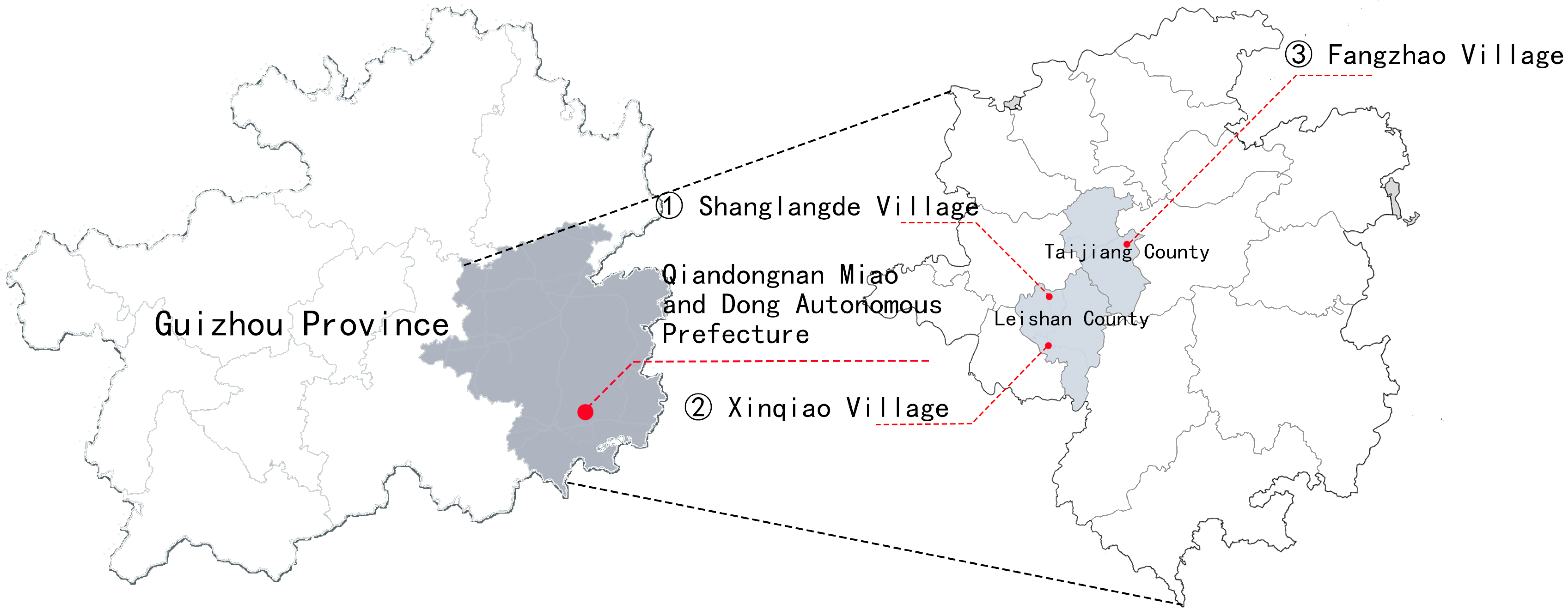
2.1. Research Objects
2.2. Data Source and Collection Methods
2.3. Research Methods
2.3.1. Fractal Dimension of Spatial Capacity
2.3.2. Aggregation Fractal Dimension
2.3.3. Analytic Hierarchy Process (AHP)
2.3.4. Research Process
3. Results
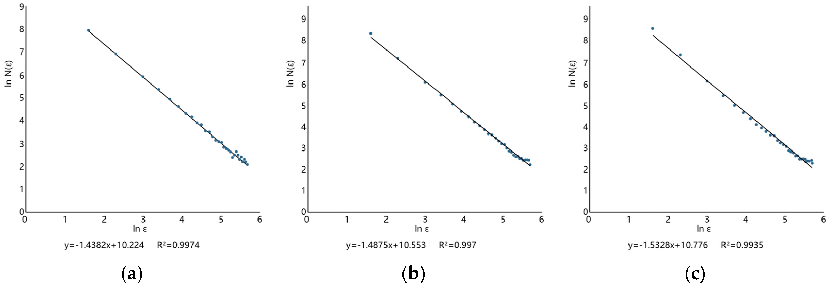
3.1. Capacity Fractal Dimension
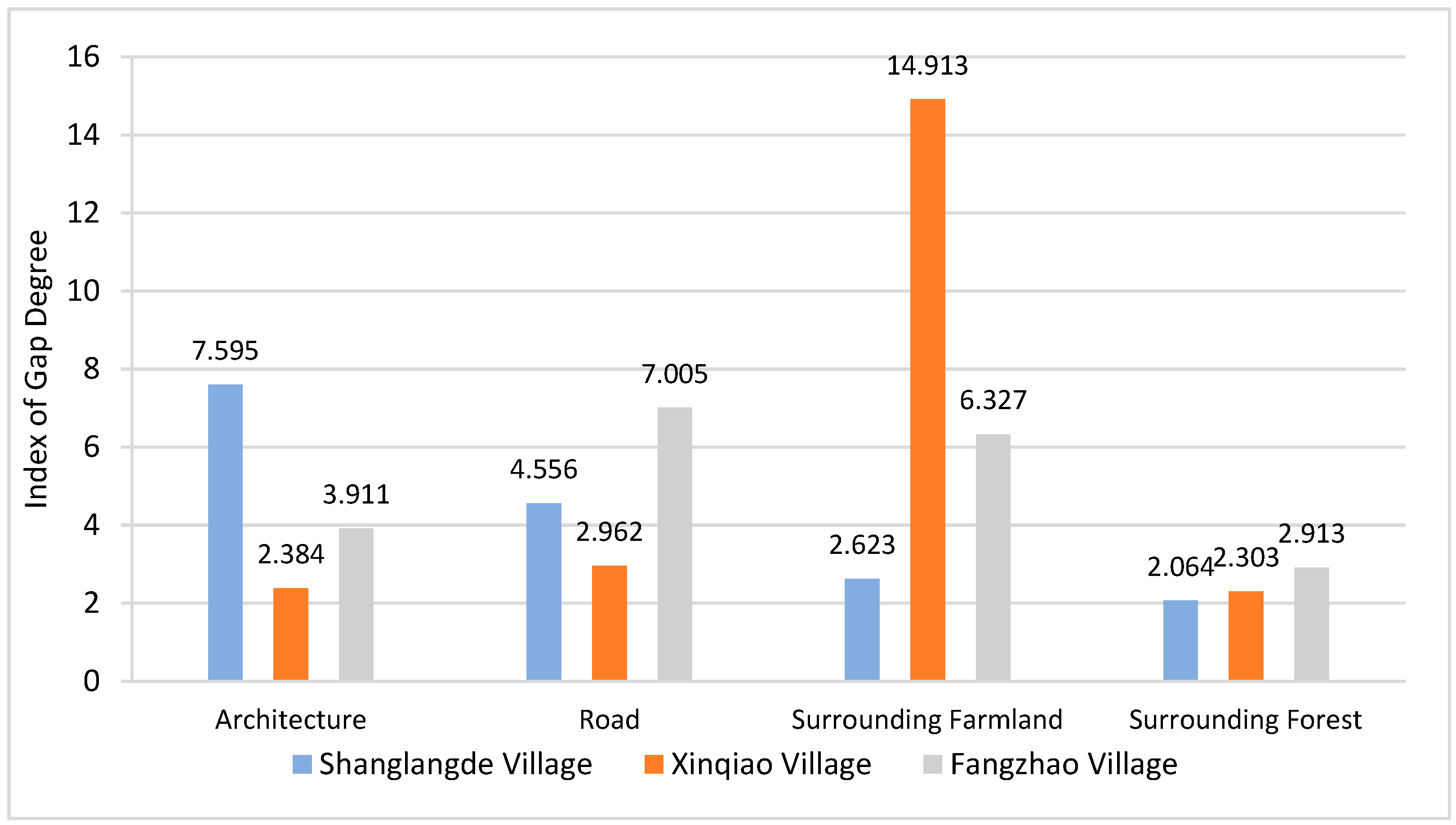
3.2. Aggregation Fractal Dimension
3.3. Analysis of Influencing Factors of the Texture Characteristics of Traditional Miao Villages
4. Discussion
4.1. Characteristics of Spatial Texture
- (1)
- The complexity characteristics of the texture
- (2)
- The aggregation characteristics of the texture
4.2. Cause and Mechanism of the Space Texture
4.3. Development Proposals
- (1)
- Plan for achieving harmony between humans and nature, and protect the ecological bottom line of villages
- (2)
- Respect the cultural and regional characteristics, and continue the characteristics of village textures
- (3)
- Maintain the traditional layout of villages and rationalize the aggregation index
5. Conclusions
- (1)
- Regarding the complexity of the spatial texture of traditional villages in Qiandongnan, there is a significant coupling relationship between the capacity fractal dimensions of village settlements, farmland, forests, and other elements, indicating clear characteristics of complexity in the texture of traditional villages. The random distribution observed in the spatial morphology of sample villages reflects the overall preservation of a relatively pristine state of the villages and a harmonious coexistence with their surrounding natural environment.
- (2)
- Regarding the aggregation characteristics of the texture of traditional villages in Qiandongnan, there is a significant correlation between the aggregation fractal dimensions of architecture, roads, farmland, forests, and other elements. The overall distribution of traditional Miao villages in Qiandongnan exhibits a random distribution pattern, indicating a state of harmonious integration with the natural environment. The gap degrees of the settlements and forest patches are relatively similar, suggesting a certain level of coordination between the two. The positive correlation between the aggregation fractal dimensions of buildings and roads indicates a coupling relationship between the texture aggregation of roads and buildings in sample villages, with mutual influence and restriction.
- (3)
- Overall, the site selection and development of traditional Miao villages in Qiandongnan are in harmony with the environment, reflecting the Miao people’s values of cherishing and respecting nature. The formation and evolution of traditional villages are influenced by both natural and humanistic factors.
Author Contributions
Funding
Institutional Review Board Statement
Informed Consent Statement
Data Availability Statement
Conflicts of Interest
References
- Ma, H.D.; Tong, Y. Spatial differentiation of traditional villages using ArcGIS and GeoDa: A case study of Southwest China. Ecol. Inform. 2022, 68, 101416. [Google Scholar] [CrossRef]
- Fang, Q.L.; Li, Z. Cultural ecology cognition and heritage value of huizhou traditional villages. Heliyon 2022, 8, e12627. [Google Scholar] [CrossRef]
- Zang, Y.Z.; Yang, Y.Y.; Cao, Z. Typical Model of Rural Transformation and Restructure in Suburban Areas: A Case Study of Huaming Township in Dongli District, Tianjin City. Geogr. Res. 2019, 38, 713–724. [Google Scholar]
- Zhang, Y.C.; Wu, Z.J. The reproduction of heritage in a Chinese village: Whose heritage, whose pasts? Int. J. Herit. Stud. 2015, 22, 228–241. [Google Scholar] [CrossRef]
- Ruan, Y.S.; Yuan, F. Aheading to the New-Water-Town-Era-Conservation and Development of the Historic Water Towns South of the Yangtze River. Urban Plan. Forum 2010, 2, 35–40. [Google Scholar]
- Duan, J.; Yin, M.; Tao, A.; Jiang, Y.; Fan, Z.X. Localized preservation and transformation of characteristic rural settlements: Perspective shift, implementation path, and policy suggestions. Urban Plan. Forum 2021, 2, 25–32. [Google Scholar]
- Mao, L.; Zhang, X.; Ma, J.; Jia, Y. Cultural relationship between rural soundscape and space in Hmong villages in Guizhou. Heliyon 2022, 8, e11641. [Google Scholar] [CrossRef]
- Long, J.Z. Qiandongnan Hmong customs and oral literature. Guizhou Ethn. Stud. 1988, 4, 176–184. (In Chinese) [Google Scholar]
- Wang, Z.L. Defensive landscape: Spiritual land, spiritual boundary and the spatial strategic layout in a Miao village. Inn. Asia 2011, 13, 117–139. [Google Scholar]
- Zhou, Z.X. Research on Hmong mountain settlement in leigong mountain, Guizhou based on text and space. Guizhou Ethn. Stud. 2016, 5, 120–127. (In Chinese) [Google Scholar]
- Xue, L.P.; Pan, X.; Wang, X.; Zhou, H.H. Stilt Houses on Top of Leigong Mountain, Ancient Miao Villages in Southeastern Guizhou Province. In Traditional Chinese Villages: Beautiful Nostalgia; Springer: Singapore, 2021; pp. 147–171. [Google Scholar]
- Kostof, S. The City Shaped: Urban Patterns and Meanings through History; Thames & Hudson: New York, NY, USA, 1991; p. 52. [Google Scholar]
- Liu, P.L. The theory and practice exploration of “remembering nostalgia” in the construction of new urbanization. Geogr. Res. 2015, 34, 1205–1212. [Google Scholar]
- Wei, D.; Yani, Y.; Yu, D. Village morphology and the construction of place identity in the Ai-hui area along the Heilongjiang River, China. River Res. Appl. 2021. [Google Scholar] [CrossRef]
- Bao, Z.T.; Zhou, J.Y. Phenomenon, reasons, and countermeasures for contemporary rural landscape decline. Urban Plan. 2014, 10, 76–84. [Google Scholar]
- Long, H.; Zou, J.; Liu, Y. Differentiation of rural development driven by industrialization and urbanization in eastern coastal China. Habitat Int. 2009, 33, 454–462. [Google Scholar] [CrossRef]
- Ma, X.Y.; Shi, Y.; Zhang, S.D.; Yang, J.B.; Guo, L. Analysis of the impact of traditional ethnic villages in Hani area on sustainable development. PLoS ONE 2023, 18, e0283142. [Google Scholar] [CrossRef] [PubMed]
- Sauer, C. The Morphology of Landscape; University of California Press: Berkeley, CA, USA, 1925; pp. 19–54. [Google Scholar]
- Yang, X.; Song, K.; Pu, F. Laws and trends of the evolution of traditional villages in plane pattern. Sustainability 2020, 12, 3005. [Google Scholar] [CrossRef]
- Ying, S.; Xiao, D.W. Identification and distinction: The social connotation of the boundary space of Hakka traditional villages in Meizhou. Small Town Constr. 2015, 4, 99–104. [Google Scholar]
- Oliskiewicz-Krzywicka, A. Demarcation Technique and Geometric Analysis of Village Boundaries Resulting from Delineation of Land Areas (ujazd) in the Middle Ages in the Wielkopolska Region (Poland). Land 2021, 10, 623. [Google Scholar] [CrossRef]
- Duan, Y.P.; Yan, L.Q.; Lai, Z.L.; Chen, Q.T.; Sun, Y.Y.; Zhang, L. The spatial form of traditional villages in Fuzhou area of Jiangxi Province determined via GIS methods. Front. Earth Sci. 2022, 1–13. [Google Scholar] [CrossRef]
- Hettiarachchi, C.J.; Priyankara, P.; Morimoto, T.; Murayama, Y. Participatory GIS-Based Approach for the Demarcation of Village Boundaries and Their Utility: A Case Study of the Eastern Boundary of Wilpattu National Park, Sri Lanka. ISPRS Int. J. Geo-Inf. 2021, 11, 17. [Google Scholar] [CrossRef]
- Li, T.; Cao, X.; Qiu, M.; Li, Y. Exploring the spatial determinants of rural poverty in the interprovincial border areas of the loess plateau in China: A village-level analysis using geographically weighted regression. ISPRS Int. J. Geo-Inf. 2020, 9, 345. [Google Scholar] [CrossRef]
- Li, T.; Li, C.K.; Zhang, R.; Cong, Z.; Mao, Y. Spatial Heterogeneity and Influence Factors of Traditional Villages in the Wuling Mountain Area, Hunan Province, China Based on Multiscale Geographically Weighted Regression. Buildings 2023, 13, 294. [Google Scholar] [CrossRef]
- Liu, L.X.; Liu, Z.J. Delineation of traditional village boundaries: The case of Haishangqiao village in the Yiluo River Basin, China. PLoS ONE 2022, 17, e0279042. [Google Scholar] [CrossRef]
- Nie, Z.; Li, N.; Pan, W.; Yang, Y.; Chen, W.; Hong, C. Quantitative research on the form of traditional villages based on the space gene—A case study of Shibadong village in western Hunan, China. Sustainability 2022, 14, 8965. [Google Scholar] [CrossRef]
- Wang, Y.F.; Yuan, Q. Morphological characteristics of rural settlements from morphogenesis perspective: A case study of rural settlements in Heilongjiang Province, China. Energy Procedia 2019, 157, 1266–1277. [Google Scholar] [CrossRef]
- Batty, M. New ways of looking at cities. Nature 1995, 377, 574. [Google Scholar] [CrossRef]
- Mohajeri, N.; Longley, P.; Batty, M. City shape and the fractality of street patterns. Quaest. Geogr. 2012, 31, 29–37. [Google Scholar] [CrossRef]
- Mandelbrot, B.B. How long is the coast of Britain? Statistical self-similarity and fractional dimension. Science 1967, 156, 636–638. [Google Scholar] [CrossRef] [PubMed]
- Mandelbrot, B.B. Fractal geometry: What is it, and what does it do? Proc. R. Soc. Lond. Math. Phys. Sci. 1989, 423, 3–16. [Google Scholar]
- Mandelbrot, B.B. The fractal geometry of Nature WH Freeman and Company; W. H. Freeman: New York, NY, USA, 1983; Volume 8, p. 406. [Google Scholar]
- Liu, S.J.; Chen, Y.J. A Three-Dimensional Box-Counting Method to Study the Fractal Characteristics of Urban Areas in Shenyang, Northeast China. Buildings 2022, 12, 299. [Google Scholar] [CrossRef]
- Chen, Y.G. Fractal Modeling and fractal dimension description of urban morphology. Entropy 2020, 22, 961. [Google Scholar] [CrossRef]
- Chen, Y.G.; Wang, Y.H.; Li, X.J. Fractal dimensions derived from spatial allometric scaling of urban form. Chaos Solitons Fractals 2019, 126, 122–134. [Google Scholar] [CrossRef]
- Liang, F.C.; Liu, S.Y.; Liu, L.M. Spatial characteristics and evolution of rural settlement landscape based on fractal theory: A case study of Xiamen, China. Chin. J. Appl. Ecol. 2017, 28, 2640. [Google Scholar]
- The General Office of the General Office of the Chinese Communist Party and the General Office of the State Council Issued the Opinions on Strengthening the Protection and Inheritance of Historical Culture in Urban and Rural Construction. Available online: https://www.gov.cn/zhengce/2021-09/03/content_5635308.htm (accessed on 27 August 2023).
- Ersahin, S.; Gunal, H.; Kutlu, T.; Yetgin, B.; Coban, S. Estimating specific surface area and cation exchange capacity in soils using fractal dimension of particle-size distribution. Geoderma 2006, 136, 588–597. [Google Scholar] [CrossRef]
- Benguigui, L.; Czamanski, D.; Marinov, M.; Portugali, Y. When and where is a city fractal? Environ. Plan. B Plan. Des. 2000, 27, 507–519. [Google Scholar] [CrossRef]
- Chen, Y.G. Fractal dimension evolution and spatial replacementdynamics of urban growth. Chaos Solitons Fractals 2012, 45, 115–124. [Google Scholar] [CrossRef]
- Feng, J.; Chen, Y.G. Spatiotemporal evolution of urban form and land-use structure in Hangzhou, China: Evidence from fractals. Environ. Plan. B Plan. Des. 2010, 37, 838–856. [Google Scholar] [CrossRef]
- Shen, G. Fractal dimension and fractal growth of urbanized areas. Int. J. Geogr. Inf. Sci. 2002, 16, 419–437. [Google Scholar] [CrossRef]
- Liang, P.; Yang, X. Landscape spatial patterns in the Maowusu (Mu Us) Sandy Land, northern China and their impact factors. Catena 2016, 145, 321–333. [Google Scholar] [CrossRef]
- Moeur, M. Characterizing spatial patterns of trees using stem-mapped data. For. Sci. 1993, 4, 756–775. [Google Scholar]
- Wang, L.F.; Xu, Y.B. Introduction to the Hierarchical Analysis Method; China Renmin University Press: Beijing, China, 1990. [Google Scholar]
- Li, J.L.; Chu, J.L.; Wang, Y.Z.; Ma, M.; Yang, X.G. Reconstruction of traditional village spatial texture based on parametric analysis. Wirel. Commun. Mob. Comput. 2022, 2022, 5151421. [Google Scholar] [CrossRef]
- Chen, Y. Fractal dimension analysis of urban morphology based on spatial correlation functions. In The Mathematics of Urban Morphology; Birkhäuser: Cham, Switzerland, 2019; pp. 21–53. [Google Scholar]
- Han, D.J.; Bu, H. Implementation of traditional village intelligent evaluation model based on parameterization. In Proceedings of the 2021 IEEE Asia-Pacific Conference on Image Processing, Electronics and Computers (IPEC), Dalian, China, 14–16 April 2021; pp. 1084–1087. [Google Scholar]
- Fu, J.; Zhou, J.; Den, Y. Heritage values of ancient vernacular residences in traditional villages in Western Hunan, China: Spatial patterns and influencing factors. Build. Environ. 2021, 188, 107473. [Google Scholar] [CrossRef]
- Jiang, Y.J.; Li, N.; Wang, Z.Y. Parametric Reconstruction of Traditional Village Morphology Based on the Space Gene Perspective—The Case Study of Xiaoxi Village in Western Hunan, China. Sustainability 2023, 3, 2088. [Google Scholar] [CrossRef]
- Schreiber, K.J.; Kintigh, K.W. A test of the relationship between site size and population. Am. Antiq. 1996, 3, 573–579. [Google Scholar] [CrossRef]
- Wang, H.; Chiou, S. Study on the sustainable development of human settlement space environment in traditional villages. Sustainability 2019, 11, 4186. [Google Scholar] [CrossRef]
- Zhang, Z.Q.; Tan, Y.M.; Xu, C.; Zhu, X.Y. Research on traditional village morphology evolution based on dynamic evolution theory of settlement: Case study of Shanbei village in western Hunan. South Archit. 2018, 3, 71–77. [Google Scholar]
- Li, S.M.; Cheng, H.H.; Wang, J. Making a cultural cluster in China: A study of Dafen Oil Painting Village, Shenzhen. Habitat Int. 2014, 41, 156–164. [Google Scholar] [CrossRef]
- Tu, S.S.; Long, H.L.; Zhang, Y.N.; Ge, D.Z.; Yi, Q. Rural restructuring at village level under rapid urbanization in metropolitan suburbs of China and its implications for innovations in land use policy. Habitat Int. 2018, 77, 143–152. [Google Scholar] [CrossRef]
- Chen, Z.Y.; Li, L.J.; Li, T.Y. The organizational evolution, systematic construction and empowerment of Langde Miao’s community tourism. Tour. Manag. 2017, 58, 276–285. [Google Scholar] [CrossRef]
- Chen, X.H.; Xie, W.Z.; Li, H.B. The spatial evolution process, characteristics and driving factors of traditional villages from the perspective of the cultural ecosystem: A case study of Chengkan Village. Habitat Int. 2020, 104, 102250. [Google Scholar] [CrossRef]


| Properties | Shanglangde Village | Xinqiao Village | Fangzhao Village |
|---|---|---|---|
| County or administrative district | Langde Town, Leishan County | Datang Town, Leishan County | Fangzhao Town, Taojiang County |
| Batch | Listed in the first batch of Chinese Traditional Village Directory | Listed in the second batch of Chinese Traditional Village Directory | Listed in the fourth batch of Chinese Traditional Village Directory |
| Time of foundation | Ming Dynasty | Ming Dynasty | Ming Dynasty |
| Core Area of the village | S = 29.19 ha | S = 8.04 ha | S = 37.35 ha |
| Population | 1132 | 1020 | 2506 |
| Origin of the village | Migration | ||
| Ethnic Homogeneity | (long skirt) Miao | (short skirt) Miao | Miao |
| Representativeness | National-level cultural heritage conservation unit; national key cultural heritage conservation unit; fifth batch of China’s famous historical and cultural villages. | Key tourist attraction village in Guizhou Province showcasing ethnic landscapes; core protection site for intangible cultural heritage of the Miao ethnic group in Leishan County | Distinctive and well-preserved ethnic cultural features; a typical representation of traditional villages of the region; third batch of “Villages with Distinctive Chinese Minority Characteristics” |
| Integrity | |||
| Diversity | Located at the foot of Mount Leigong, the village is built along the mountainside, with the mountain behind and facing the water, at an altitude ranging from 735 to 1280 m. The spatial structure is characterized by clustered blocks, and the development level is high. | Spatial integrity, functional completeness, and rich environmental elements. The terrain within the village is relatively flat, with an average elevation of 910 m. The spatial structure is characterized by a strip-like pattern, and the development level is moderate. | Located at the foothills of the Mount Leigong in the Miaoling Mountain Range, the village is built along the mountainside with proximity to water. It has an average elevation of 1058 m. The spatial structure is characterized by scattered distribution, and the development level is relatively low. |
 |  |
| Spatial Morphology of Shanglangde Village | |
 |  |
| Spatial Morphology of Xinqiao Village | |
 |  |
| Spatial Morphology of Fangzhao Village | |
| Target Layer | Criterion Layer | Indicator Layer | |
|---|---|---|---|
| Influencing factors of the mimicry characteristics of the texture of traditional Miao villages | Natural environment(N) | Topography | N01 |
| Hydrogeology | N02 | ||
| Humanistic and historic factors (H) | Patriarchal ethics | H01 | |
| Site Selection Concept | H02 | ||
| Ethnic Customs | H03 | ||
| Religion | H04 | ||
| War Defense | H05 | ||
| Social production (S) | Social Organization Structure | S01 | |
| Production and Lifestyle | S02 | ||
| Material Production and Circulation | S03 | ||
| Population Migration | S04 | ||
| Economic policy (E) | Policies and Regulations | E01 | |
| Economic System | E02 | ||
| Planning and Construction | E03 | ||
| Economic Activity | E04 | ||
| Industrial Structure | E05 | ||
| Tourism Development | E06 |
| Side Length of the Boxes (m) | Shanglangde Village | Xinqiao Village | Fangzhao Village | ||||||
|---|---|---|---|---|---|---|---|---|---|
| Non-Empty Box Counts of Settlements | Non-Empty Box Counts of Farmland | Non-Empty Box Counts of Forests | Non-Empty Box Counts of Settlements | Non-Empty Box Counts of Farmland | Non-Empty Box Counts of Forests | Non-Empty Box Counts of Settlements | Non-Empty Box Counts of Farmland | Non-Empty Box Counts of Forests | |
| 290 | 8 | 9 | 10 | 4 | 2 | 3 | 9 | 10 | 10 |
| 280 | 9 | 11 | 11 | 4 | 3 | 3 | 9 | 10 | 10 |
| 270 | 10 | 11 | 11 | 4 | 4 | 3 | 10 | 10 | 11 |
| 260 | 9 | 11 | 11 | 4 | 5 | 3 | 10 | 11 | 11 |
| 250 | 11 | 11 | 11 | 5 | 6 | 4 | 10 | 11 | 11 |
| 240 | 10 | 11 | 12 | 5 | 7 | 4 | 12 | 11 | 12 |
| 230 | 12 | 12 | 12 | 5 | 8 | 4 | 14 | 12 | 14 |
| 220 | 14 | 12 | 12 | 5 | 9 | 5 | 15 | 15 | 16 |
| 210 | 12 | 13 | 12 | 7 | 10 | 6 | 14 | 16 | 17 |
| 200 | 11 | 13 | 14 | 9 | 11 | 7 | 15 | 17 | 17 |
| 190 | 14 | 14 | 14 | 7 | 12 | 8 | 15 | 18 | 19 |
| 180 | 15 | 16 | 16 | 7 | 3 | 8 | 19 | 18 | 21 |
| 170 | 16 | 17 | 17 | 7 | 3 | 8 | 18 | 19 | 22 |
| 160 | 17 | 19 | 18 | 8 | 3 | 8 | 19 | 22 | 22 |
| 150 | 21 | 23 | 22 | 7 | 3 | 9 | 23 | 23 | 27 |
| 140 | 22 | 19 | 24 | 10 | 4 | 9 | 22 | 23 | 27 |
| 130 | 23 | 27 | 26 | 12 | 4 | 9 | 30 | 23 | 32 |
| 120 | 27 | 31 | 29 | 9 | 4 | 10 | 29 | 31 | 37 |
| 110 | 33 | 36 | 36 | 10 | 4 | 11 | 34 | 33 | 43 |
| 100 | 35 | 38 | 37 | 13 | 4 | 12 | 43 | 37 | 47 |
| 90 | 45 | 46 | 44 | 15 | 4 | 13 | 49 | 37 | 57 |
| 80 | 50 | 55 | 52 | 19 | 6 | 20 | 58 | 47 | 68 |
| 70 | 64 | 64 | 61 | 24 | 6 | 21 | 67 | 55 | 84 |
| 60 | 74 | 84 | 80 | 25 | 7 | 24 | 87 | 68 | 108 |
| 50 | 101 | 108 | 107 | 35 | 7 | 32 | 123 | 84 | 149 |
| 40 | 138 | 152 | 151 | 51 | 11 | 44 | 167 | 111 | 200 |
| 30 | 212 | 233 | 237 | 78 | 16 | 70 | 264 | 162 | 332 |
| 20 | 369 | 425 | 470 | 158 | 26 | 131 | 507 | 280 | 590 |
| 10 | 1015 | 1300 | 1585 | 521 | 71 | 417 | 1507 | 723 | 1592 |
| 5 | 2780 | 4154 | 5563 | 1662 | 188 | 1384 | 4215 | 1731 | 3685 |
| Primary Factors | Weight | Consistency Test | Secondary Factors | Weight | Consistency Test |
|---|---|---|---|---|---|
| Natural environment (N) | 0.2922 | λmax = 4.0709 CR = 0.0265 < 0.1 Test passed | Topography | 0.7500 | λmax = 2 CR = 0.0000 < 0.1 Test passed |
| Hydrogeology | 0.2500 | ||||
| Humanistic and historic factor (H) | 0.4133 | Patriarchal ethics | 0.2426 | λmax = 5.1825 CR = 0.0407 < 0.1 Test passed | |
| Site Selection Concept | 0.4678 | ||||
| Ethnic Customs | 0.0689 | ||||
| Religion | 0.0951 | ||||
| War Defense | 0.1255 | ||||
| Social production (S) | 0.1078 | Social Organization Structure | 0.4781 | λmax = 4.2148 CR = 0.0805 < 0.1 Test passed | |
| Production and Lifestyle | 0.2760 | ||||
| Material Production and Circulation | 0.1018 | ||||
| Population Migration | 0.1440 | ||||
| Economic policy (E) | 0.1867 | Policies and Regulations | 0.1928 | λmax = 6.4262 CR = 0.0677 < 0.1 Test passed | |
| Economic System | 0.0992 | ||||
| Planning and Construction | 0.3760 | ||||
| Economic Activity | 0.0787 | ||||
| Industrial Structure | 0.1249 | ||||
| Tourism Development | 0.1983 |
Disclaimer/Publisher’s Note: The statements, opinions and data contained in all publications are solely those of the individual author(s) and contributor(s) and not of MDPI and/or the editor(s). MDPI and/or the editor(s) disclaim responsibility for any injury to people or property resulting from any ideas, methods, instructions or products referred to in the content. |
© 2023 by the authors. Licensee MDPI, Basel, Switzerland. This article is an open access article distributed under the terms and conditions of the Creative Commons Attribution (CC BY) license (https://creativecommons.org/licenses/by/4.0/).
Share and Cite
Gong, L.; Yang, J.; Wu, C.; Zhou, H. Fractal Characteristics of the Spatial Texture in Traditional Miao Villages in Qiandongnan, Guizhou, China. Sustainability 2023, 15, 13218. https://doi.org/10.3390/su151713218
Gong L, Yang J, Wu C, Zhou H. Fractal Characteristics of the Spatial Texture in Traditional Miao Villages in Qiandongnan, Guizhou, China. Sustainability. 2023; 15(17):13218. https://doi.org/10.3390/su151713218
Chicago/Turabian StyleGong, Lei, Jianzhu Yang, Chong Wu, and Hui Zhou. 2023. "Fractal Characteristics of the Spatial Texture in Traditional Miao Villages in Qiandongnan, Guizhou, China" Sustainability 15, no. 17: 13218. https://doi.org/10.3390/su151713218
APA StyleGong, L., Yang, J., Wu, C., & Zhou, H. (2023). Fractal Characteristics of the Spatial Texture in Traditional Miao Villages in Qiandongnan, Guizhou, China. Sustainability, 15(17), 13218. https://doi.org/10.3390/su151713218