
Ecological Risk Assessment and Impact Factor Analysis of Ecological Spatial Patterns in Coastal Counties: Taking Dalian Pulandian District as an Example

Abstract
:1. Introduction
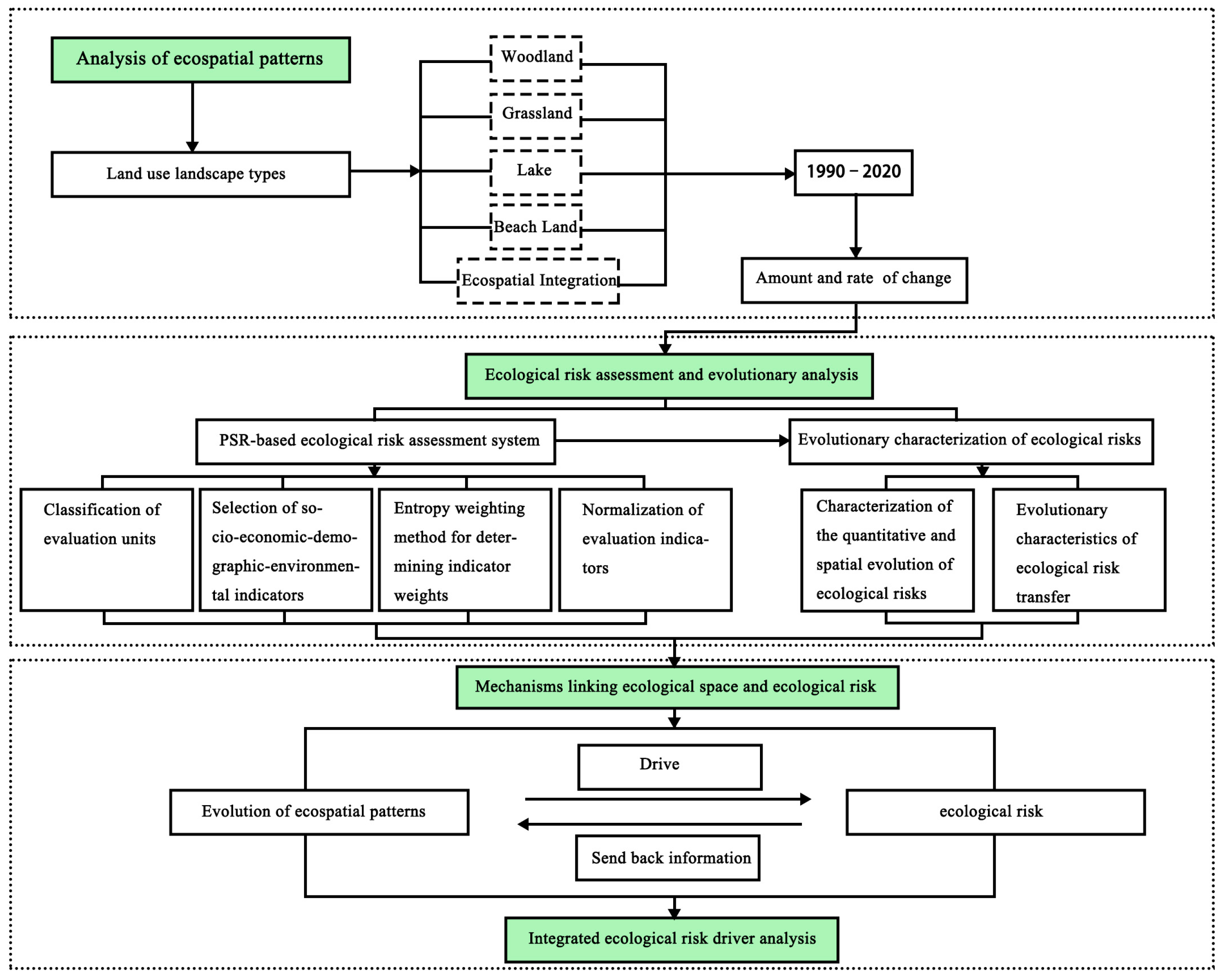
2. Materials and Methods
2.1. Study Area
2.2. Construction of Ecological Risk Index System of PSR Model
2.2.1. Classification of Evaluation Units
2.2.2. PSR Model and Evaluation Index Selection
2.2.3. PSR Evaluation Weight Determination Method
2.2.4. Synthesis of Integrated Ecological Risk Evaluation Index
2.3. Geographically Weighted Regression GWR Model
3. Results
3.1. Ecological Spatial Pattern Analysis
3.2. Spatial and Temporal Evolutionary Characteristics of Ecological Risks
3.2.1. Comprehensive Ecological Risk Level Change and Spatial Distribution
3.2.2. Characteristics of Changes in the Integrated Ecological Risk Subsystem
3.3. Integrated Ecological Risk Driver Analysis
4. Discussion
5. Conclusions
- (1)
- An analysis of the characteristics of the ecological spatial pattern’s evolution in the study area between 1990 and 2020 was carried out, and the observations include an increase in the main ecological land and a decrease in the area of arable land in Pulandian district; a net increase in the amount of woodland, grassland, and water in the pattern’s ecological spatial pattern; and the transfer from coastal mudflats to construction land. This study demonstrates that most ecological space patches are severely fragmented; only the coastal mudflat patches are high overall in terms of fragmentation degree. The degree of fragmentation of water areas tends to be serious, and the degree of ecological space fragmentation in the area near construction land is serious when combined with the landscape index to analyze the change characteristics of ecological space fragmentation and heterogeneity. The overall evolution trend of ecological space is differentiated, and the evolution pattern has a tendency to be fragmented and heterogeneous as a result of the study area’s increased infrastructure building, resource consumption, and disregard for long-term land planning.
- (2)
- The evolution of ecological risk over the past 30 years was assessed using the DPS model of the integrated social, economic, and environmental index system, and its weights were determined based on the entropy weighting method and the mean square difference method. The ecological risk index demonstrated a continuously increasing trend, with an increase of 14.14%. In the study area, the high-risk and higher-risk areas displayed a discernible increasing trend, whereas the low-risk areas exhibited a trend that first decreased, increased, and then decreased again. The medium-risk areas displayed a persistently decreasing trend. In particular, in the southern portion of the study region with areas exhibiting high rates of urbanization, such as Fengrong, Tiexi, and Taiping, the high-risk areas in the study area expanded dramatically by 73.17% over the 30-year period. The state index exhibited a reduction followed by an increase in change, the response index exhibited a decrease followed by an increase in change, and the pressure change in ecological risk exhibited a linear increasing trend. These distributions have a strong relationship relative to the local economy, society, and environment.
- (3)
- The dominant drivers of ecological risk in Pulandian district are urbanization rate, environmental protection investment-to-GDP ratio, ecosystem service index, and ecological space-to-land ratio. This analysis was carried out using exploratory regression analysis and the GWR model. The urbanization rate is among the driving spatial characteristics that are clearly negative, while the ecological space–land use ratio, the ecosystem service index, and the ratio of environmental protection investment to GDP are clearly positive. The ratio of environmental protection investment to GDP has considerable geographical dividing characteristics, while the share of ecological space and the ecosystem service index exhibit clearer block-driving characteristics. The urbanization rate also shows strong band-driving characteristics.
Author Contributions
Funding
Institutional Review Board Statement
Informed Consent Statement
Data Availability Statement
Conflicts of Interest
References
- Li, Q.P.; Zhang, Z.D.; Wang, L.W.; Chuanxun, Y.; Jie, Z.; Chen, Y.; Yuchan, C. Landscape pattern optimization in Ningjiang River Basin based on landscape ecological risk assessment. Acta Geogr. Sin. 2019, 74, 1420–1437. [Google Scholar]
- Liu, C.Y.; Zhang, K.; Liu, J.P. A long-term site study for the ecological risk migration of landscapes and its driving forces in the Sanjiang Plain from 1976 to 2013. Acta Ecol. Sin. 2018, 38, 3729–3740. [Google Scholar]
- Zhang, Y.; Zhang, F.; Zhou, M.; Li, X.H.; Ren, Y.; Wang, J. Landscape ecological risk assessment and its spatio-temporal variations in Ebinur Lake region of inland arid area. Chin. J. Appl. Ecol. 2016, 27, 233–242. [Google Scholar]
- Long, T.; Deng, S.P.; Wu, Y.; Zhu, X. Advancement in Study on Development of Ecological Risk Assessment Framework. J. Ecol. Rural Environ. 2015, 31, 822–830. [Google Scholar]
- Peng, J.; Dang, W.X.; Liu, Y.X.; Zong, M.; Hu, X. Review on landscape ecological risk assessment. Acta Geogr. Sin. 2015, 70, 664–677. [Google Scholar]
- Zeng, J.J.; Zou, M.L.; Guo, J.J.; Kai, L.; Yang, C.; Chen, G.G.; Xue, D.X. Ecological Risk Assessment and Its Research Progress. Adm. Tech. Environ. Monit. 2017, 29, 1–5+10. [Google Scholar]
- Kang, Z.W.; Zhang, Z.Y.; Wei, H.; Liu, L.; Ning, S.; Zhao, S.; Wang, T.; Tian, H. Landscape ecological risk assessment in Manas River Basin based on land use change. Acta Ecol. Sin. 2020, 40, 6472–6485. [Google Scholar]
- Xu, L.; Luo, W.; Zhou, B.T. Landscape Ecological Risk Assessment of Farming-Pastoral Ecozone Based on Land Use Change-A Case Study of the Yanghe Watershed, China. J. Nat. Resour. 2015, 30, 580–590. [Google Scholar]
- Zou, R.j.; Zhang, Y.Z.; He, H.C. Ecological risk assessment based on land use changes in the coastal area in Yancheng city. Geogr. Res. 2016, 35, 1017–1028. [Google Scholar]
- Jing, Y.Q.; Zhang, F.; Chen, L.H.; Zhang, Y.; Wang, X.; Li, Z.; Kuang, H.-T. Investigation on eco-environmental effects of land use/cover-landscape patternand climate change in Ebinur Lake Wetland Nature Reserve. Acta Sci. Circumstantiae 2017, 37, 3590–3601. [Google Scholar]
- Liu, H.; Wang, H.; Zhang, X.W. Research review on ecological security assessment. Chin. J. Ecol. 2006, 25, 74–78. [Google Scholar]
- Mao, X.L.; Ni, J.R. Recent Progress of Ecological Risk Assessment. Acta Sci. Nat. Univ. Pekin. 2005, 4, 646–654. [Google Scholar]
- Wang, G.P.; Min, Q.W.; Ding, L.B.; He, S. Comprehensive disaster risk assessment index system for national parks based on the PSR model. Acta Ecol. Sin. 2019, 39, 8232–8244. [Google Scholar]
- Yue, D.-X.; Zeng, J.-J.; Yang, C.; Zou, M.-L.; Li, K.; Chen, G.-G.; Guo, J.-J.; Xu, X.-F. Research on Risk Assessment of the Ecological Environment in Gannan Plateau Based on the PSR and Entropy Weight Matter-Element Extension Model. Ecol. Econ. 2017, 33, 175–180. [Google Scholar]
- Wang, Q.; Li, S.; Li, R. Evaluating water resource sustainability in Beijing, China: Combining PSR model and matter-element extension method. J. Clean. Prod. 2019, 206, 171–179. [Google Scholar] [CrossRef]
- Xu, Y.; Zhong, Y.X.; Feng, X.H.; Xu, L.; Zheng, L. Ecological risk pattern of Poyang Lake basin based on land use. Acta Ecol. Sin. 2016, 36, 7850–7857. [Google Scholar]
- Pan, J.H.; Liu, X. Landscape ecological risk assessment and landscape security pattern optimization in Shule. Chin. J. Ecol. 2016, 35, 791–799. [Google Scholar]
- Kang, P.; Chen, W.P.; Wang, M.E. Advancesin ecosystem service-based ecological risk assessment. Acta Ecol. Sin. 2016, 36, 1192–1203. [Google Scholar]
- Wang, P.; Wang, Y.J.; Liu, X.P.; Xiao, C.; Fuxing, K. Ecological risk assessment of an ecological migrant resettlement region based on landscape structure: A case study of Hongsibu in Ningxia. Acta Ecol. Sin. 2018, 38, 2672–2682. [Google Scholar]
- Zhang, T.; Liu, Y.X.; Peng, J.; Wang, Y. Correlation of the landscape ecological risk on multi-scales in Shenzhen City. Chin. J. Ecol. 2016, 35, 2478–2486. [Google Scholar]
- Huang, M.Y.; He, X. Study On Landscape Pattern Changes And Driving Forces Of Ecological Risk in Chaohu Lake Basin. Resour. Environ. Yangtze Basin 2016, 25, 743–750. [Google Scholar]
- Zhou, J.Y.; Meng, L.H.; Wu, S.X.; Xie, Y.; Chen, H. Spatialtemporal Evolution Characteristics and Influencing Factors of Ecological Security Pattern in Zhejiang Province. Bull. Soil Water Conserv. 2020, 40, 266–272+287. [Google Scholar]
- Gao, Y.; Liu, X.P.; Yuan, W.P. Ecological Risk Assessment And Prediction Of Unused Land Development In Inland River Basin Of Arid Arear—A Case Study In Kaidu River Basin. Chin. J. Agric. Resour. Reg. Plan. 2020, 41, 203–211. [Google Scholar]
- He, X.; Jiang, G.H.; Zhang, R.J.; Ma, W.; Zhou, T. Temporal and Spatial Variation of Land Ecosystem Health Based. on the Pressure- State-Response Model A Case Study of Pinggu District, Beijing. J. Nat. Resour. 2015, 30, 2057–2068. [Google Scholar]
- Chen, J.J.; Li, T.H. Landscape Ecological Risk Analysis for Jingzhou City Based on PSR Model and Projection Pursuit Method. Acta Sci. Nat. Univ. Pekin. 2017, 53, 731–740. [Google Scholar]
- Fu, Z.Y.; Xu, X.G.; Lin, H.P.; Wang, X. Regional ecological risk assessment of in the Liaohe River Deltawetlands. Acta Ecol. Sin. 2001, 21, 365–373. [Google Scholar]
- Party History Research Office of the CPC Pulandian Municipal Committee. Pulandian Nianjian 2020; North United Publishing Media (Group) Co.: Shenyang, China, 2020. [Google Scholar]
- Yang, J.; Huang, X. The 30 m annual land cover dataset and its dynamics in China from 1990 to 2019. Earth Syst. Sci. Data 2021, 13, 3907–3925. [Google Scholar] [CrossRef]
- Song, Y.Y.; Xue, D.Q.; Xia, S.Y.; Mi, W. Change characteristics and formation mechanism of the territorialspatial pattern in the Yellow River Basin from 1980 to 2018,China. Geogr. Res. 2021, 40, 1445–1463. [Google Scholar]
- Xu, H.T.; Zhou, L.F.; Cheng, Q. Study on ecosystem health evaluation and risk assessment for Linghekou wetlands based on a PSR model. Acta Ecol. Sin. 2017, 37, 8264–8274. [Google Scholar]
- Xie, X.F.; Wu, T.; Xiao, C.; Jiang, G.; Bian, H.; Ma, Y.; Chen, J. Ecological Security Assessment of the Dongyang River Watershed Using PSR Modeling. Resour. Sci. 2014, 36, 1702–1711. [Google Scholar]
- Xie, G.D.; Zhen, L.; Lu, C.X.; Xiao, Y.; Chen, C. Expert Knowledge Based Valation Method of Ecosystem Services in China. J. Nat. Resour. 2008, 23, 911–919. [Google Scholar]
- Zhou, D.; Tian, Y.; Jiang, G. Spatio-temporal investigation of the interactive relationship between urbanization and ecosystem services: Case study of the Jingjinji urban agglomeration, China. Ecol. Indic. 2018, 95, 152–164. [Google Scholar] [CrossRef]
- Cao, Q.; Zhang, X.W.; Ma, H.K.; Wu, J. Review of landscape ecological risk and an assessment framework based on ecological services: ESRISK. Acta Geogr. Sin. 2018, 73, 843–855. [Google Scholar]
- Chen, X.Y.; Xie, G.Z.; Zhang, J.P. Landscape ecological risk assessment of land use changes in the coastal area of Haikou City in the past 30 years. Acta Ecol. Sin. 2021, 41, 975–986. [Google Scholar]
- Liao, L.W.; Qin, J.X.; Liu, Y.Q.; Li, T. Study on Ecological Elasticity of Hunan Province Based on Land Use Transition. Econ. Geogr. 2015, 35, 16–23. [Google Scholar]
- Peng, J.; Liu, Y.; Li, T.; Wu, J. Regional ecosystem health response to rural land use change: A case study in Lijiang City, China. Ecol. Indic. 2017, 72, 399–410. [Google Scholar] [CrossRef]
- Kang, P.; Chen, W.; Hou, Y.; Li, Y. Linking ecosystem services and ecosystem health to ecological risk assessment: A case study of the Beijing-Tianjin-Hebei urban agglomeration. Hebei urban agglomeration. Sci. Total Environ. 2018, 636, 1442–1454. [Google Scholar] [CrossRef]
- Levin, P.S.; Fogarty, M.J.; Murawski, S.A.; Fluharty, D. Integrated Ecosystem Assessments: Developing the Scientific Basis for Ecosystem-Based Management of the Ocean. PLoS Biol. 2009, 7, e14. [Google Scholar] [CrossRef] [Green Version]
- Deboudt, P. Towards coastal risk management in France. Ocean Coast. Manag. 2010, 53, 366–378. [Google Scholar] [CrossRef]
- Mendes, G.M.; Arnaldo, W.; Ferreira, D.S.R. Integrating Habitat Availability, Permeability, and Configuration in a Model of Landscape Connectivity: The Contribution of Habitat’s Site-to-Site. Environ. Manag. 2023, 71, 998–1010. [Google Scholar] [CrossRef]


| Guideline Layer | Indicator Layer | Entropy Method | Mean Square Error Method | Combined Weights | Positivity and Negativity |
|---|---|---|---|---|---|
| Pressure | Population density | 0.0278 | 0.0800 | 0.0539 | Negative |
| GDP per capita | 0.1015 | 0.0870 | 0.0943 | Positive | |
| Urbanization rate | 0.0693 | 0.1059 | 0.0876 | Negative | |
| Total output value of agriculture, forestry, animal husbandry, and fishery as a percentage of agriculture, forestry, livestock and fisheries | 0.0526 | 0.0773 | 0.0649 | Positive | |
| Forest land area per capita | 0.0237 | 0.0712 | 0.0475 | Positive | |
| Percentage of construction land area | 0.2317 | 0.0947 | 0.1632 | Negative | |
| Status | Ecosystem services index | 0.2010 | 0.0931 | 0.1470 | Positive |
| Ecological resilience index | 0.0628 | 0.0837 | 0.0732 | Negative | |
| Landscape ecological risk intensity | 0.0720 | 0.0912 | 0.0816 | Positive | |
| Response | Percentage of ecological space | 0.0530 | 0.0676 | 0.0603 | Positive |
| Landscape diversity index | 0.0245 | 0.0675 | 0.0460 | Positive | |
| Environmental investment as a percentage of GDP | 0.0802 | 0.0809 | 0.0806 | Positive |
| Type | 1990–2000 | 2000–2010 | 2010–2020 | 1990–2020 | ||||
|---|---|---|---|---|---|---|---|---|
| Amount of Change/km2 | Rate of Change/% | Amount of Change/km2 | Rate of Change/% | Amount of Change/km2 | Rate of Change/% | Amount of Change/km2 | Rate of Change/% | |
| Woodland | 35.901 | 8.57% | −5.418 | −1.19% | 103.283 | 22.97% | 133.766 | 31.92% |
| Grassland | −26.885 | −23.80% | −1.986 | −2.31% | −34.675 | −41.23% | −63.546 | −56.25% |
| Waters | −3.528 | −9.58% | 17.824 | 53.54% | −6.183 | −12.10% | 8.114 | 22.04% |
| Coastal mudflats | 2.883 | 1.51% | −14.553 | −7.49% | −14.940 | −8.31% | −26.610 | −13.91% |
| Ecological space integration | 8.371 | 1.10% | −4.132 | −0.54% | 47.486 | 6.21% | 51.725 | 6.80% |
| Risk Level | 1990 | 2000 | 2010 | 2020 | ||||
|---|---|---|---|---|---|---|---|---|
| Area/km2 | Proportion/% | Area/km2 | Proportion/% | Area/km2 | Proportion/% | Area/km2 | Proportion/% | |
| High risk | 287.35 | 10.74% | 401.64 | 15.01% | 436.81 | 16.33% | 486.76 | 18.19% |
| Higher risk | 461.86 | 17.26% | 611.20 | 22.84% | 634.20 | 23.70% | 799.80 | 29.89% |
| Medium risk | 1255.16 | 46.91% | 1164.49 | 43.53% | 1070.41 | 40.01% | 972.79 | 36.36% |
| Low risk | 671.05 | 25.08% | 498.09 | 18.62% | 534.00 | 19.96% | 416.07 | 15.55% |
| Driving Factors | Minimum Value | Maximum Value | Average Value | Standard Deviation |
|---|---|---|---|---|
| Urbanization rate | −0.032 | −0.007 | −0.018 | 0.007 |
| Environmental investment as a percentage of GDP | −0.075 | 0.449 | 0.058 | 0.154 |
| Ecosystem services index | 0.128 | 0.446 | 0.247 | 0.096 |
| Percentage of ecological space | 0.281 | 0.396 | 0.325 | 0.036 |
Disclaimer/Publisher’s Note: The statements, opinions and data contained in all publications are solely those of the individual author(s) and contributor(s) and not of MDPI and/or the editor(s). MDPI and/or the editor(s) disclaim responsibility for any injury to people or property resulting from any ideas, methods, instructions or products referred to in the content. |
© 2023 by the authors. Licensee MDPI, Basel, Switzerland. This article is an open access article distributed under the terms and conditions of the Creative Commons Attribution (CC BY) license (https://creativecommons.org/licenses/by/4.0/).
Share and Cite
Qu, M.; Tian, Y.; Liu, B.; Xu, D. Ecological Risk Assessment and Impact Factor Analysis of Ecological Spatial Patterns in Coastal Counties: Taking Dalian Pulandian District as an Example. Sustainability 2023, 15, 11805. https://doi.org/10.3390/su151511805
Qu M, Tian Y, Liu B, Xu D. Ecological Risk Assessment and Impact Factor Analysis of Ecological Spatial Patterns in Coastal Counties: Taking Dalian Pulandian District as an Example. Sustainability. 2023; 15(15):11805. https://doi.org/10.3390/su151511805
Chicago/Turabian StyleQu, Ming, Yu Tian, Bingxi Liu, and Dawei Xu. 2023. "Ecological Risk Assessment and Impact Factor Analysis of Ecological Spatial Patterns in Coastal Counties: Taking Dalian Pulandian District as an Example" Sustainability 15, no. 15: 11805. https://doi.org/10.3390/su151511805
APA StyleQu, M., Tian, Y., Liu, B., & Xu, D. (2023). Ecological Risk Assessment and Impact Factor Analysis of Ecological Spatial Patterns in Coastal Counties: Taking Dalian Pulandian District as an Example. Sustainability, 15(15), 11805. https://doi.org/10.3390/su151511805