Article

Commercial Culture as a Key Impetus in Shaping and Transforming Urban Structure: Case Study of Hangzhou, China

1
Department of Regional and Urban Planning, Zhejiang University, Hangzhou 310058, China
2
Department of Real Estate and Construction, The University of Hong Kong, Hong Kong 999077, China
3
Department of Urban Planning and Design, The University of Hong Kong, Hong Kong 999077, China
*
Authors to whom correspondence should be addressed.
Sustainability 2023, 15(13), 10620; https://doi.org/10.3390/su151310620
Submission received: 13 March 2023 / Revised: 21 June 2023 / Accepted: 25 June 2023 / Published: 5 July 2023
(This article belongs to the Topic Sustainability in Heritage and Urban Planning)

Abstract

:
Although the forces or impetuses that influence an urban structure are diverse, as has been fully studied by scholars from diverse research fields, some have played key roles. We endeavor to explore the key forces and mechanisms forming and transforming the urban spatial structure through Hangzhou, a multi-identity city. Upon studying classical ancient texts, historical maps, critical and recent literature, and POI data, we argue that the first and foremost driver of Hangzhou is commercial culture, rather than any other factors. Under a diachronic view and with graphic analysis, we distinguished Hangzhou’s three major transformations during the last 900 years. Each transformation was, respectively, driven by the complicated commercial culture, which was mixed up with other elementary cultures, such as civil, leisure, landscape, and industrial. Furthermore, urban heritages were formed, inherited, revitalized, and reutilized during the transformation processes, which, in turn, enriched the commercial culture and vividly reshaped Hangzhou’s urban structure.

1. Introduction

Hangzhou, an ancient Chinese city with more than 2000 years’ history, initially became known to the Western world in the thirteenth century due to the record of the Venetian traveler Marco Polo [1]. However, as one destination on the Silk Road, Arabic merchants and travelers had already visited the city even earlier [2], during Hangzhou’s highlight moment, when it was the dynastic capital of an oriental empire, the Southern Song Dynasty (1127 CE–1279 CE). Japanese scholars took the lead in studying China’s Tang (618–907 CE) and Song (960–1279 CE) cities, as they wrote the first urban history studies of these cities in the 1930s and 1940s, which triggered the interest of urban historians from other countries and internationally,; an interest that has persisted to this day [3].
Scholars’ major interests in China’s ancient capital cities such as Hangzhou are due to aspects, such as the social and economic development [4,5], urban planning [6], urban form or layout [7,8,9,10], spatial structure [11,12], functional areas [13], and comparative studies with other countries’ capitals [14,15], among others. Some attention has also been paid to the analysis of urban form, spatial structure [16,17,18], urban heritage [19,20], and the evolutionary mechanism of modern local Chinese cities since the late Qing era, or from the nineteenth century on, and in contemporary China. Hangzhou is among these local cities, as its status as the country’s capital was revoked following the Southern Song Dynasty, but it still functions as a critical local administrative and commercial center.
While Hangzhou’s urban form, like those of most of the other ancient Chinese capital cities, is considered to have remained stable over a long period [21], its inner structure and patterns have changed greatly. Scholars from research fields, such as history, urban study, urban history, and planning history, have inspected Hangzhou’s general history, with particular concern paid to Hangzhou’s urban changes and the underlying mechanism of those changes. They attributed Hangzhou’s urban structuring and restructuring factors to the complicated political, economic, social, cultural, religious, and even natural or landscape factors, as well as the interactions between those factors [1,4,22,23,24,25].
Specifically, quite a few studies have focused on the political or institutional factor being the main driver in shaping Hangzhou during the Southern Song Dynasty and contemporarily. Hangzhou became the dynastic capital in 1137 CE and was the largest city in the country when China’s ‘medieval urban revolution’ [4] took place, in which Hangzhou played a key role. Many studies have acknowledged the existence and timing of this revolution, considering the institutional changes [4], structural changes [3], and dramatic transformations or transitions [1] of Chinese cities that took place during Tang to Song China, or from the ninth to the twelfth century. The political aspect is still critical, as Zhu [26] also studied Hangzhou’s urban restructuring from the early 2000s, or since the post-reform stage, considering China cities’ broad shift from industrialism to urbanism as related to political legitimacy. Three years later, he focused on Hangzhou’s recent changes to a post-socialist city, considering the aspects of historical legacies, expanded urban range, and land use restructuring, among others [27].
Some studies attributed this institutional change or transformation and the correlated urban restructuring primarily to economic reasons. Southall, for example, studied the Southern Song Hangzhou or Hangchow region, paying particular attention to the reasons that the capitalist and industrial revolution failed to take hold in the Southern Song, though its elite was just as capable, innovative, and rational as those in eighteenth century England, who generated the industrial revolution [22]. Wang [28] retraced Hangzhou in the Ming (1368–1644 CE) and Qing Dynasty (1636–1912 CE), namely China’s late imperial period, through the reorganization of its urban space, and acknowledged it as a nexus of commerce, administration, and popular culture. Some current works studied Hangzhou within the context of China’s economic reform. Wei and Fang [29], for example, examined the rapid growth of Hangzhou’s urban space and regarded China’s reforms and globalization as the vital factors underlying its urban growth and restructuring.
Some other studies emphasized the evolution and function of the natural and cultural landscapes of the city, particularly the West Lake, in forming ancient Hangzhou as an icon of Chinese landscape appreciation [25] and modern Hangzhou as a scenic city [24,30]. In addition to the water landscape, exemplified by the West Lake, some attention has also been paid to the mountain landscape, exemplified by Wushan [31,32,33], in constituting Hangzhou’s urban landscape. As these types of Shan-shui, or water–mountain landscapes, have rich cultural connotations, cultural [25] and religious [33] perspectives are also considered when tracing the ways in which Hangzhou’s urban structure evolved throughout history.
Obviously, the drivers of a city’s development are complicated and comprehensive, and these have been reviewed. Moreover, scholars attribute different drivers to Hangzhou’s urban restructuring during different historic periods. However, Hangzhou is a multi-identity Chinese city, namely an ancient dynastic capital and modern local administrative center, and has been the largest oriental city for roughly 900 years. It is also a new oriental city of leisure and can hardly be studied through either a political or economic lens. Is there a primary impetus in the process shaping Hangzhou’s urban structure throughout time? By what mechanism does this impetus shape and reshape Hangzhou’s urban structure, if such an impetus exists?
To answer the first question, we assume, through studying the ancient texts, historical maps, and related literature, that the first and foremost driver of Hangzhou’s sustainable development and urban structure transformation is commercial culture, rather than other factors. Commercial development force and correlated commercial culture once made Hangzhou the primary prosperity metropolis of some ancient empires and are still shaping contemporary Hangzhou. This force also generates and reuses the city’s abundant legacies and heritages. As a result, Hangzhou presently occupies three World Heritages, namely the Archaeological Ruins of Liangzhu City, the West Lake, and the Grand Canal of Hangzhou section, which were, respectively, formed in different historical periods and have been sustainably retained. While the active roles of the West Lake and the Grand Canal of Hangzhou Section in shaping the city are widely recognized and studied, that of the Archaeological Ruins of Liangzhu City, Hangzhou’s newly added World Heritage, in reframing the spatial structure of Hangzhou remains to be studied. Most current studies on Liangzhu are concentrated on its own rise and fall [34], its interaction between the environment and climate change [35], and its Neolithic culture [36], among others.
In addition, we find, through a literature review, that the literature concerning Hangzhou’s urban transformation is made up of either historic or contemporary studies. In other words, Hangzhou’s urban transformation is either studied in the history and urban history fields, which mainly focus on historic Hangzhou in periods, such as the Tang, Song, Qing era, and Modern China, or in the urban geography and urban study fields, which center on contemporary Hangzhou. Furthermore, scholars have made some temporal ‘slices’ within historic periods, such as the Southern Song [37], the Ming and Qing [28], the later Qing to the Republic of China (1910s–1940s) [24], and the post-reform era [26], among others.
In terms of this situation, we endeavor to explore the possibility of exploring Hangzhou’s urban transformation in a continuous way, namely from as early as the South Song Dynasty to the present day, rather than in a sectional way as other studies take. We argue that it is by sequential scanning and diachronic viewing that the transformation mechanism and sustainable development of Hangzhou’s urban structure be distinctly demonstrated.
Thus, to answer the second question, we identify and elaborate on three key transformations of Hangzhou’s urban spatial structure since the twelfth century in this article to show how the complicated commercial impetus contributes to the shaping and reshaping of Hangzhou’s urban structure. The first transformation occurred in the Southern Song Dynasty when Hangzhou became the capital city and when early capitalist relation of production sprouted. The city was then obscured in history when the Song empire was conquered by the Yuan emperor Kublai Khan. The second one happened in the Qing Dynasty to the Republic of China. Hangzhou, acting as a provincial capital, embraced its revitalization by grasping the opportunity of industrial and commercial development and became the nation’s top handcraft manufacturing and commerce center and then a modern industrial and commercial hub. The third one took place during China’s reform and post-reform periods [26], when Hangzhou took the tourist and leisure industry as the new urban development driver and successfully integrated its commercial culture with leisure and heritage culture. The analysis of these three transformations constitutes Section 3, Section 4 and Section 5 of this article, and the date and methods of our study are shown in Section 2 (Figure 1).

2. Data Resources and Methods

Our materials and data for analysis are from four resources. The first resource is classical ancient texts, which illustrate Chang′an, Dongjing, and Hangzhou’s economic development, social conditions and transition, and urban pattern and spatial structure during some key historic periods. We sort out the contents from the texts that are related to urban structure and link them with our graphic analysis (Table 1).
The second one is historic maps and painting, base maps, and current satellite maps. The historic maps and painting provide raw spatial structure information about the cities. The base maps are amended through the historic maps, which offer corrected historic urban form and structure. The current satellite maps are from Google Earth, which both provide a base map for analyzing current Hangzhou and a reference for comparing Hangzhou’s urban structure transformations in different periods. Based on these maps and information from the ancient texts, we make graphic analysis of Hangzhou’s and several ancient cities’ urban structure to illustrate the spatial shaping and reshaping of Hangzhou. Specifically, we identify the same spatial elements, such as districts, streets, and complex, during different periods to illustrate the sustainability and transformation of Hangzhou’s urban structure (Table 2).
The third one is the point-of-interest (POI) data. We use Python code to crawl POI data from Gaode Map in Hangzhou’s core urban area, namely Shangcheng District, Gongshu District, and Xihu District, in November 2022. The data collected include information about the name, latitude, longitude, and type of POI. According to the POI classification code of Gaode Map and our research needs, the sub category of shopping centers or commercial complexes under the category of shopping services is chosen as the object of analysis. Through screening, deduplication, rectification, and spatial matching, a total of 49 commercial complexes are obtained. Some of the commercial complexes’ positions are marked in Section 5.1.
The fourth one is critical and up-to-date literature, both in English and Chinese, on Hangzhou’s general history and its urban structure transformation in various periods.

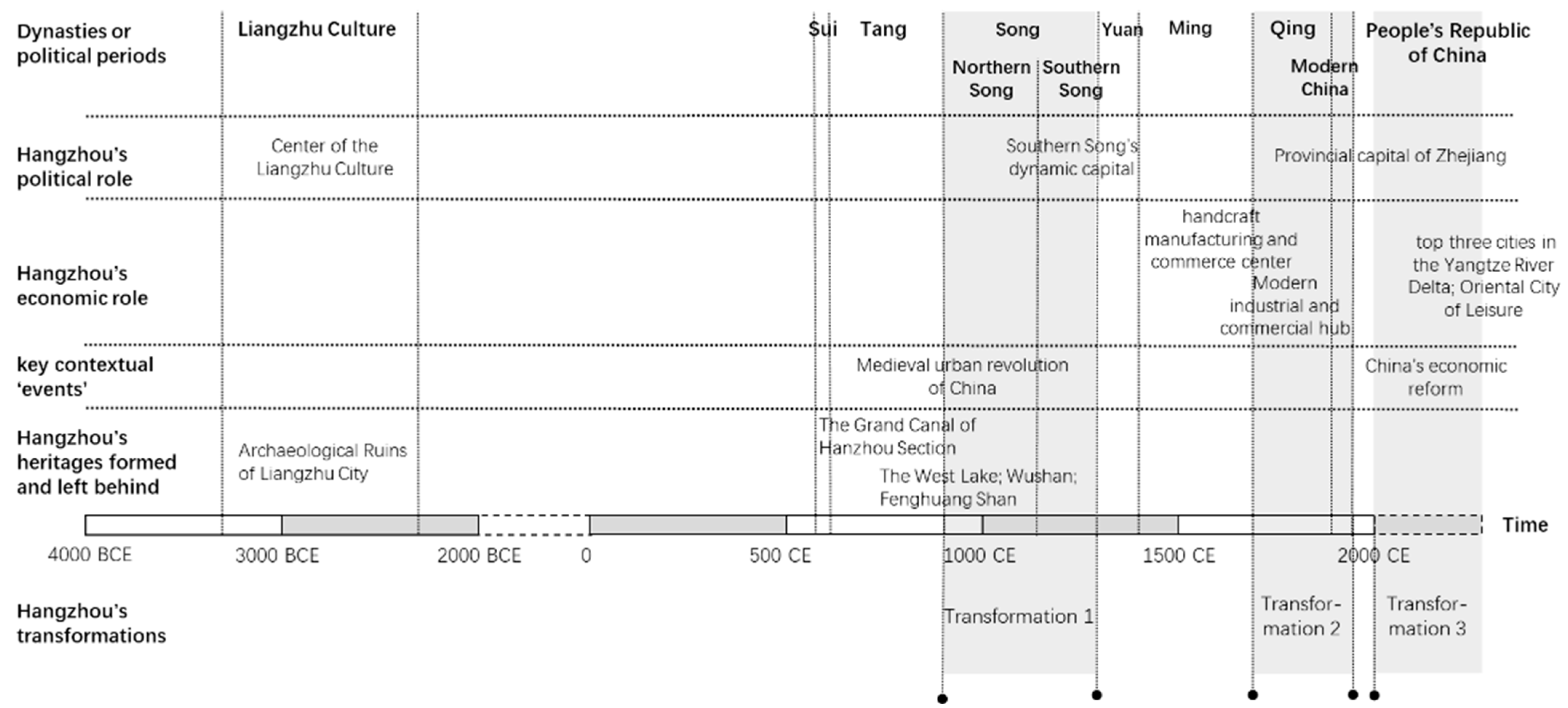
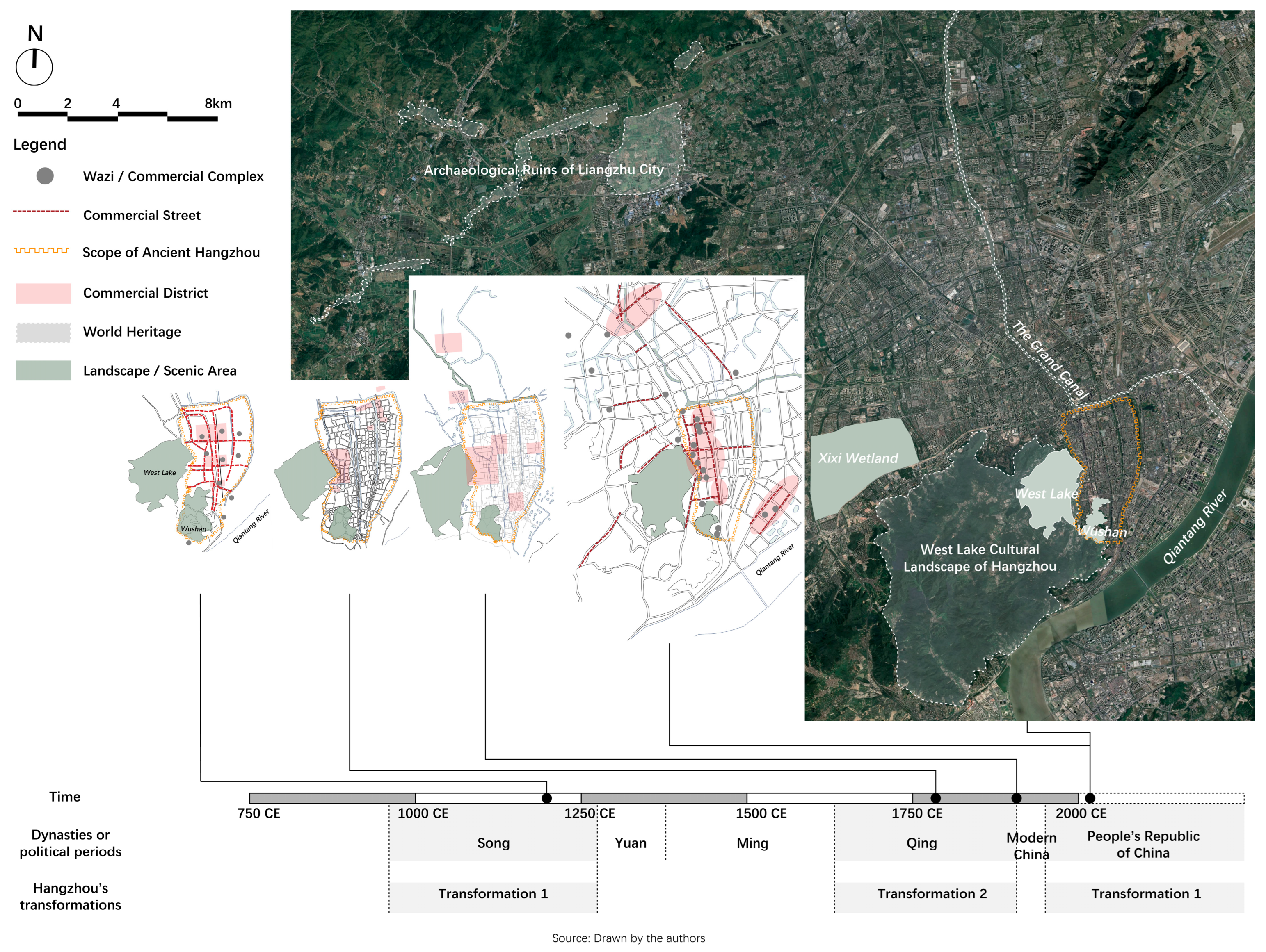
3. Transformation 1: Lin’an in the Southern Song Dynasty, 1137–1279

The commercial and civic culture that drove Hangzhou’s first urban structure transformation took shape within the emerging early capitalist relation of production in Song China when the country reached a peak of commercial prosperity. The culture instantly casted their influence on the Song cities, particularly the two capital cities, the Northern Song Dongjing and the Southern Song Hangzhou, which was renamed Lin’an in 1129 CE. The two Song capitals formed sharply different urban structure from the Tang capital Chang′an.

3.1. General Urban Structure before and after the Song Dynasty

In accordance with the emerging early capitalist relation in China, urban structure changed from an enclosed Li-Fang system to an open and free Fang-Xiang system during the mid-Tang to the Song dynasty [6]. A comparison between these two systems is necessary to comprehend Hangzhou’s first transformation.

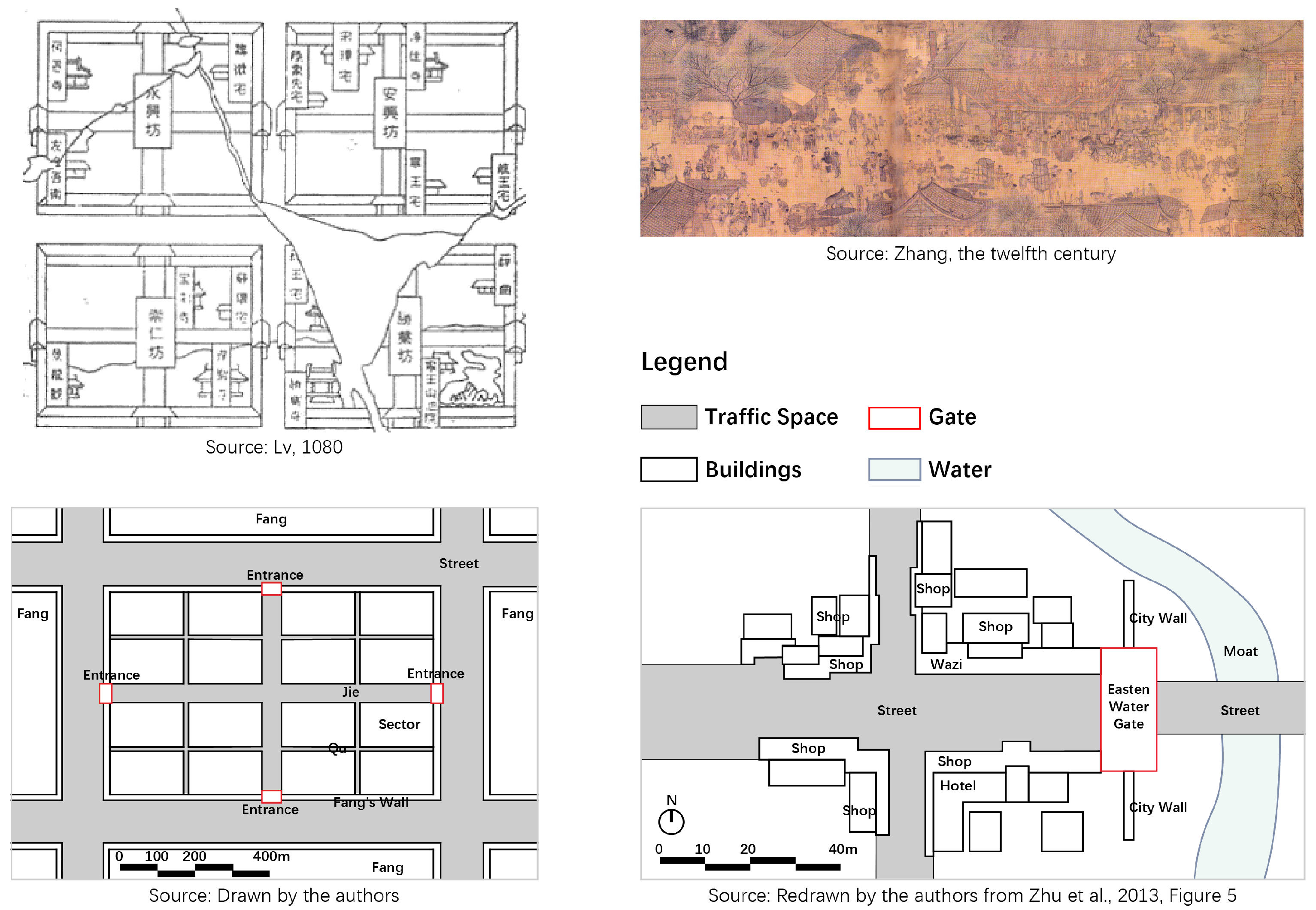
3.1.1. Li-Fang System

China’s general urban structure before the Song Dynasty was called Li-Fang system, which consisted of enclosed and distinct urban wards or ‘Fangs’, rectangular in shape and encircled by walls. All functional areas, such as the neighborhoods and marketplaces, were, respectively, settled within the Fangs. No gates except main entrances of Fangs and of aristocrats’ houses and Buddhist monasteries could be set on such walls. Inside the Fangs, the first-grade internal crisscross roads called ‘Jie’, which opened onto the Fang’s four main entrances, and the second-grade roads called ‘Qu’ further divided a Fang’s interior space into multiple sectors. Along these roads, the gates of the ordinary residences or shops could be set up. People passed in and out the Fang through the four Fang’s entrances or gates, which were opened and closed at a fixed time every day. In this way, the spatiotemporal design of the Fang facilitated the imposition of a dusk-to-dawn curfew to its residents or merchants and of the emperor’s control on them (Figure 2).
However, as early as in the mid-Tang (approximately in the ninth century), there were breakthrough indications of the enclosed system due to the accelerating commercialization [4] or the development of commodity economy. Yangzhou, the primary commercial city of the mid-Tang, perfectly exemplified an intermediate stage of a gradual changing or transforming process: the separate market areas and residential areas, which were previously, respectively, fixed into the wards, began to merge together, and an open urban commercial net and border-free neighborhoods were taking form.
Skinner [4] innovatively coined an influential concept, the ‘medieval urban revolution’ of China, to illustrate such key institutional changes, which began in the mid-Tang and culminated during the Southern Song. To him, a key feature of this revolution was ‘the disappearance of the enclosed marketplace, along with the walled-ward system, and their replacement by “a much freer street plan in which trade and commerce could be conducted anywhere within the city or its outlying suburbs”’ [4]. Likewise, Lincoln [1] recognized this change as the ‘Tang-Song transition’ on urban civilization, which occurred from the ninth to the twelfth centuries.

3.1.2. Fang-Xiang System

The most visible outcome of the Tang-Song urban revolution or transition was the replacement of the enclosed Li-Fang system with an open and free Fang-Xiang system or ward-lane system. The spatial structure of Northern Song Dongjing, which meant ‘eastern capital’, as differentiating from the ‘western capital’ Chang′an, was a prime example of Fang-Xiang system [9], as the Northern Song Dynasty ‘witnessed the most rapid economic growth in the history of China’ [22]. Contrary to the Li-Fang system, the spatial structure of the Fang-Xiang system featured the disappeared Fang’s walls; the scattered shops and stores, as well as the residences of common people, along the streets, lanes, bridges, waterfronts, among others, to all over the city; and the substitution of the concentrated marketplaces with a well-developed urban commerce net. These changes were notably recorded by the Song litterateur Meng Yuanlao in his masterpiece The Dream of Hua in the Eastern Capital.
Although both the mid-Tang and Song China shared the process of institutional urban restructuring, the rise of a civil culture during the Song era as a companion of the then matured prosperous commodity economy made it different from the Tang era. New markets, wine shops, theaters, and teahouses sprang up like mushrooms in the new urban space of Song cities to cater to people’s huge recreation and consumption demands under the rising civil culture. Song Dynasty artist Zhang Zeduan’s marvelous painting Riverside Scenes at the Qingming Festival depicted a bustling scene of such civil culture, urban life, and new urban space at the Qingming Festival in Dongjing in detail [49] (see Figure 2). By contrast, the enclosed traditional urban space only reflected the emperor’s will and facilitated the governments’ administration but restricted urban life in terms of time and space.

3.2. Comparison between Chang′an and Lin’an

A comparison between Chang′an, the capital of the Tang Dynasty, and Lin’an in the following aspects would be helpful in understanding the Tang-Song dramatic but gradual changes promoted by the commercial culture.
  • City name
The names of the two cities implied completely opposite meanings: while Chang′an referred to a permanent resting place, Lin’an, or in Marco Polo’s word, Quinsay, referred to ‘a temporary resting place’ [22].
  • Urban planning
Chang′an, then known as ‘Daxing’, was totally newly planned in the Sui Dynasty (518–619 CE) within the Li-Fang system with strict grid. By contrast, Lin’an was reconstructed on the basis of the capital of Wuyue Kingdom (907–978 CE), which was economically developed, less planned, and had a flexible urban spatial pattern featured by long and narrow blocks along rivers [52].
  • Markets and subsidiary facilities
Chang′an has two marketplaces: Dongshi (the Eastern Marketplace) and Xishi (the Western Marketplace). According to the Song scholar Song Minqiu’s Gazetteer of Chang′an, both covered two Fangs’ area, which was about 900 × 900 m. Dongshi largely contained luxury stores that mainly served the royal family and aristocrats as it was close to the royal palace and Fangs where aristocrats lived. By contrast, Xishi targeted common people and ‘international’ merchants. It also included a large quantity of foreign shops run by international merchants, including the Sogdians, Arabians, and Persians.
In contrast to Chang′an, Lin’an had a complicated trade and recreational system consisting of commercial districts, streets, and professional trade streets. Three integrated commercial districts were distributed from south to north along the Yujie or the Imperial Way, a three-mile long central axis of Lin’an [6], and each took different functions. The southern district, close to the Imperial Palace and the national central administrative district, was an upscale commercial district including upmarket restaurants. The middle district, the largest in Lin’an, had been around since the mid-Tang era and sold a full range of goods. The northern district converged all kinds of leisure and entertainment venues. In addition to these comprehensive districts on the Imperial Way, there were commercial streets for retail, and all kinds of professional trade streets served the guilds stretching along other main urban traffic axes and rivers. Among the professional trade streets, the wholesale ones were adjoined to the land gates and water gates of the city. A large warehouse area was shaped in the northwest part of the city, near the water and land transportation hub [6].
  • Recreational places
Chang′an’s recreational places were mainly Xichang or theater fields in the marketplaces of Dongshi and Xishi and in Buddhist monasteries, such as Ci’en Temple and Qinglong Temple. Similar to the residences and shops, monasteries were also fixed in Fangs [6].
However, under the boom of commercial and civil culture, Lin’an established grand public complexes called Wazis or Washes, which accommodated varied recreational facilities and activities [53]. According to the Gazetteer of Lin’an from the Xianchun Reign Period and Dream of Hangzhou, there were 17 Wazis in Lin’an [45,54]. Mimicking Dongjing, the birthplace of the Wazi, these grand complexes were mainly located either along the Imperial Way or outside Lin’an city but adjoined the city gates, namely where people converged. According to the Old Man of West Lake ‘s Record of Luxuriant Scenery by the Old Man of West Lake, Lin’an’s largest and most comprehensive public complex was called Bei Wa or Northern Wa in the northern district. Other grand Wazis, like Da Wa (big complex), Zhong Wa (central complex), and Nan Wa (southern complex), lined the central axis.
  • Scenic areas
Buddhist monasteries were common scenic areas for Chang′an’s civilians to visit. According to Xu Song’s Research of Blocks in Two Ancient Capital Cities of Tang Dynasty, for example, Ci’en Temple was famous for its peonies, which were flooded with people every spring. In addition, the eastern suburb and southern corner of Chang′an featured beautiful nature landscape. While the eastern suburb was occupied by aristocrats and bureaucrats’ villas and gardens, the southern corner was open to the public. However, Qujiang Pond and Furong Park, two of the most famous public views at the southern corner, were situated within the Fang-like marketplaces and neighborhoods.
Contrary to Chang′an, Lin’an’s natural landscape such as the West Lake was stretched freely outside the city wall to the west of the urban area. Inside the city wall, hills, like Wushan and Fenghuang Shan, together with the ‘open and “participatory” lake’ [33] and the urban inland waterway, constituted an interpenetrative Shan-Shui or mountain–water natural and urban landscape of Lin’an. Jia [33] called this landscape a ’paradigm‘ in Southern Song Lin’an, namely ‘a free combination of an artificial urban texture and a natural environment’, which strengthened the development of urbanization and commercialization. Thereafter, such a combination remained as one of the critical heritages and features of Hangzhou until today and performed a vital role in making Hangzhou a scenic city and one of the most famous tourist destinations in China since the early twentieth century [31] (Figure 3 and Table 3).

4. Transformation 2: Hangzhou in the Qing Dynasty and the Republic of China, 1636–1940s

Commercial and leisure culture, which was formed under the industrial and commercial development in late imperial China [4,55], promoted Hangzhou’s second transformation, following the commercial and civic culture under the early capitalist relation of production in mid-imperial China during Hangzhou’s first transformation. Specifically, two forces for the second urban restructuring could be distinguished. The first was the silk and tea culture in the Ming and early Qing time when Hangzhou was a national hub of handicraft production and trade. The second was the modern industrial, commercial, and landscape culture in the late-Qing and early twentieth century when Hangzhou, together with Suzhou and Nanjing, had to take back seats as Shanghai gradually evolved as the prime city of China’s modern industry, economy, and trade from the late nineteenth century.

4.1. Hangzhou in Ming and Early Qing Dynasty

After the Yuan defeated the Southern Song, Hangzhou fell into a trough of political status and economic development due to natural and man-made disasters such as the war [56]. Politically, its status as a dynamic capital was lost as Beijing, and temporarily Nanjing, succeeded it to be the capital city. Instead, it was downgraded to a the local political center of China, namely the provincial capital of Zhejiang province, in the early Qing era in 1662 CE until today. Economically, it was not until the Ming Dynasty when Hangzhou gradually recovered as a hub of trade and commerce in the Lower Yangzi region, as it was the southern terminus on the Beijing–Hangzhou Grand Canal, the economic artery of the Song through to Qing empires. It came to be the biggest one of the three Imperial Silk Production Bureaus or Weaving and Dyeing Offices during the Qing (the other two Bureaus were located in Nanjing and Suzhou) [55], as estimated in output [23], and one of the top cities for handcraft manufacturing and commerce [31]. Meanwhile, other handcrafts and commercial cities competing with Hangzhou proliferated, especially from the mid-Qing era. Therefore, Hangzhou was hardly a trend leader in urban transformation and culture, especially since the mid-nineteenth century when the Taiping rebel outbroke [31]. However, its industrial combination of textile and clothing industries featured by silk production and leisure industry featured by tea production and consumption could still ensure its uniqueness among similar cities.

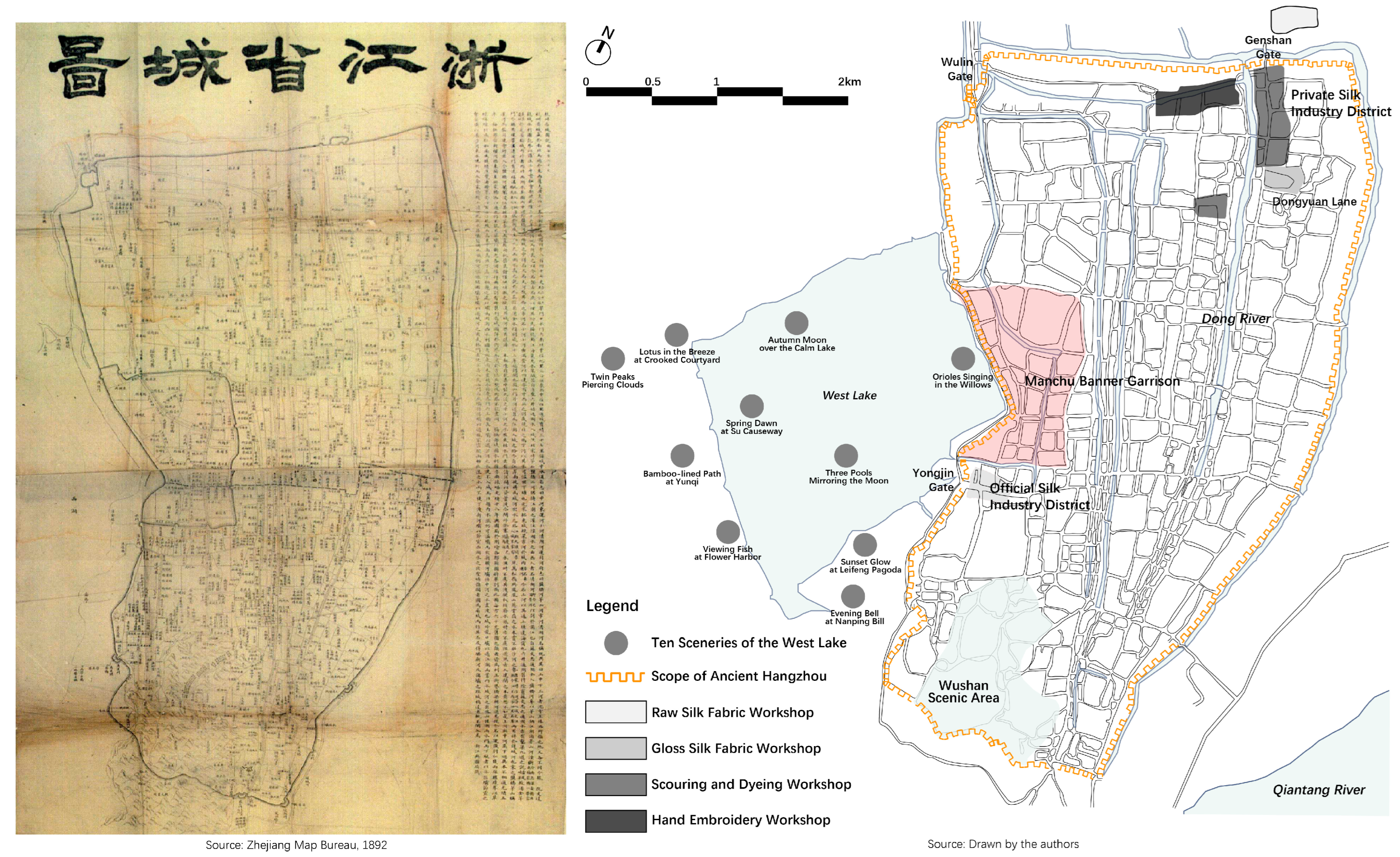
4.1.1. Silk Culture as the Commercial Culture

As early as the Song Dynasty, systematic market divisions had been made between the comprehensive and professional and between wholesale and retail [57]. During the Ming and Qing Dynasty, market division had been more sophisticated as a market system than before. This trend was exemplified by the locations of Hangzhou’s official and private silk industry and trade districts. The official district was located in the west of the city, especially gathering at the downtown area inside one city gate, the Yongjin Gate, while the private one was in the north of the city and could be sorted into two categories. The private workshops at Dongyuan Lane produced gloss silk fabric. Those out of the Genshan Gate, another city gate, produced raw silk fabric. As parts of the silk industry chain, scouring and dyeing workshops were situated on both shores of Dong River, ranging from the area of gloss silk fabric workshops to the area of raw silk fabric workshops. In addition, hand embroidery workshops gathered at the western side of those dyeing workshops (Figure 4). These two districts, together with the wholesale and retail silk stores scattered near them, formed a network of Hangzhou’s silk manufacturing and trading.

4.1.2. Tea Culture as the Leisure Culture

Tea culture, one of many Chinese or Eastern Asian leisure cultures, also flourished at the time. Hangzhou was the primary producing area of Longjing (Dragon well) tea, one of the five superior types of tea in Ming China [58]. As a result, teahouses slowly replaced Wazi as a public entertainment spot. However, teahouses differed from Wazi in three aspects. First, a teahouse’s main functions were information exchange and deal clinching but not as comprehensive as those of Wazi. Second, there were entertainment activities displayed every day in teahouses, but traditional drama performances from Wazi were transferred to theaters. Third, tea tasting and tea culture were considered elegant and associated with the upper elites and literati, while entertainments in Wazi were often regarded as popular or even vulgar. Wu Zimu even commented, in Volume 19 of the Dream of Hangzhou by citing the Song scholar Ni Deweng’s A Record of the Capital’s Famous Scenic Spots: Performers of the Washe (都城纪胜·瓦舍众伎), that the Wazi was ‘a place of bohemianism for both the elites and common people’ (士庶放荡不羁之所). Wushan or the City-god hill supplanted the scattered Song Wazi as Hangzhou’s major commercial and popular entertainment area for the common people in the late-Qing time due to its religious status, which conglomerated the city-god temple and many other Buddhist and Daoist temples and, thus, conglomerated the people [31].

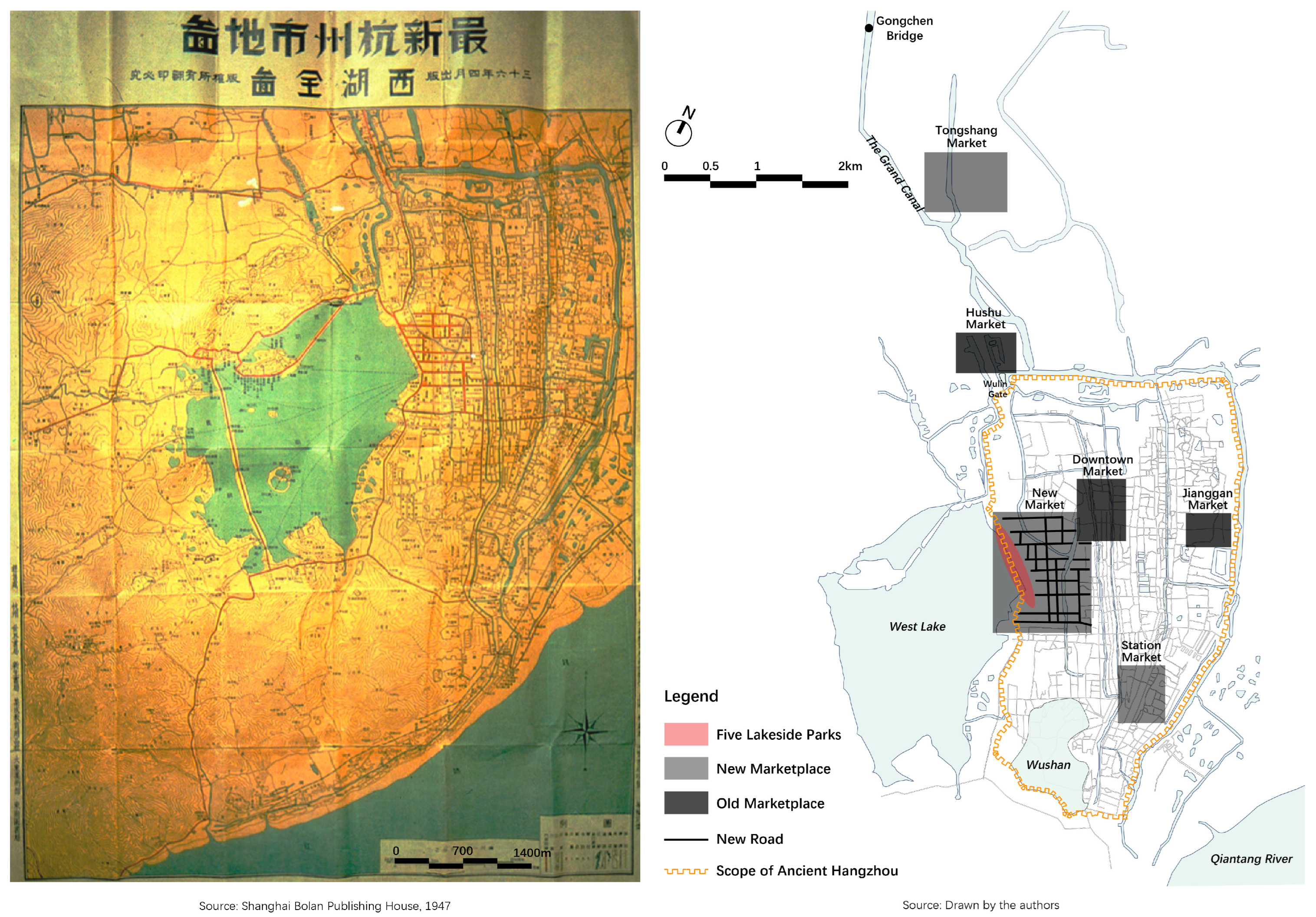
4.2. Hangzhou in the Late-Qing and Early Twentieth Century

The urban structure of many Chinese cities, including Hangzhou, was fiercely reshaped in the late-Qing time when Western and Japanese colonists forced the Qing government to open the doors of the country and when China’s modern industry began to develop. In 1895, Japan forced the Qing Government to sign the unequal Treaty of Shimonoseki. Hangzhou was among the list of China’s open treaty ports according to the Treaty. On one hand, it marked the beginning of the semi-colonial process of Hangzhou. On the other hand, it paved the way for Hangzhou’s development of modern capitalism and industry. The mushroomed modern industrial area in Gongchen area and along the Grand Canal, together with the establishment of a lakeside business district called the New Business District in 1913, largely changed Hangzhou’s urban pattern, since ancient times, as it further set free the previously enclosed urban space.

4.2.1. Modern Industrial and Commercial Culture

Hangzhou formed three ‘old’ marketplaces in the late-Qing era, namely the Downtown Market, which served the bureaucrat, the Jianggan Market, and the Hushu Market area. Three new ones, namely the Tongshang Market, the Station Market, and the New Market, gradually took shape from the late nineteenth to the early twentieth century. Accordingly, these six marketplaces constituted the major modern commercial framework of Hangzhou (Figure 5).
Although these three new marketplaces were generated out of different causes, they were all related to Hangzhou’s modern industrial and commercial development. After the city was opened as a treaty port, the Japanese established a concession area near Gongchen Bridge in 1896, a vital transport hub on the Grand Canal of Hangzhou section. A comprehensive commercial district named Tongshang Market was then set up south of the Japanese concession [59]. From then, the area around the Japanese concession and Gongchen Bridge and along the Grand Canal became a cradle for Hangzhou’s modern industry and commerce, as many national capitalist factories, such as the reeling mill and cotton mill, chose to locate there.
The establishment and naming of the Station Market should be attributed to the opening of a newly constructed railway between Hangzhou and Shanghai in 1911, as it was formed near the railway station.
After the 1911 Revolution, troops of the Qing Government in Hangzhou surrendered. In 1913, the newly composed government planned to dispose all the land of the Manchu banner garrison, the former military fortress and residential district of the Qing’s Manchu troops, and to build a new center of tourism and commerce called the New Business District to supplant the old commercial district around Wushan [32]. With the New Business District plan carried out in 1913, a lakeside market called New Market emerged.

4.2.2. Landscape Culture

The West Lake had already been famed for its ‘world famous sceneries’ in the Song Dynasty, as recorded in the Song scholar Zhou Mi’s Former Matters of Wulin. It was revitalized in Qing Dynasty as the Song’s scenic and cultural heritage when Emperor Kangxi (1654–1722 CE) standardized the ‘Ten Views of West Lake’ originating in the Song [25]. Emperor Yongzheng, son of Kangxi, nominated an additional eighteen sceneries, which indicated that the scope of the West Lake as a scenic area was enlarged greatly. Emperor Qianlong, son of Yongzheng, wrote at least five series of poems on the Ten Views [25]. Although the purpose of the three emperors was to coopt and administer the Jiangnan Han literati through patronizing the West Lake, the core of the Jiangnan region [25,31], the three emperors’ endorsements formed Hangzhou’s initial landscape culture made the city one of China’s leading tourist destinations from then on.
With the implementation of the 1913 plan, the city walls between the West Lake and the city were demolished. As a result, the lake was, for the first time, merged into the urban area. New lakefront roads were built on the original sites of the walls. In addition, former roads in the Manchu banner garrison were completely abandoned, and a new straight road system was designed and built, which was quite inharmonious to the city’s original road framework. Furthermore, five lakeside parks were created. About ten years later, this new lakefront area, with a new name of Hubin, meaning the shore of the lake, had developed into a new prosperous ‘downtown’ with the highest property value in the city. Meanwhile, Hangzhou rose as a tourist city for the new middle class from Shanghai who preferred ‘authentic’ Chinese culture [25], which was constituted from Hangzhou’s leisure and landscape culture.

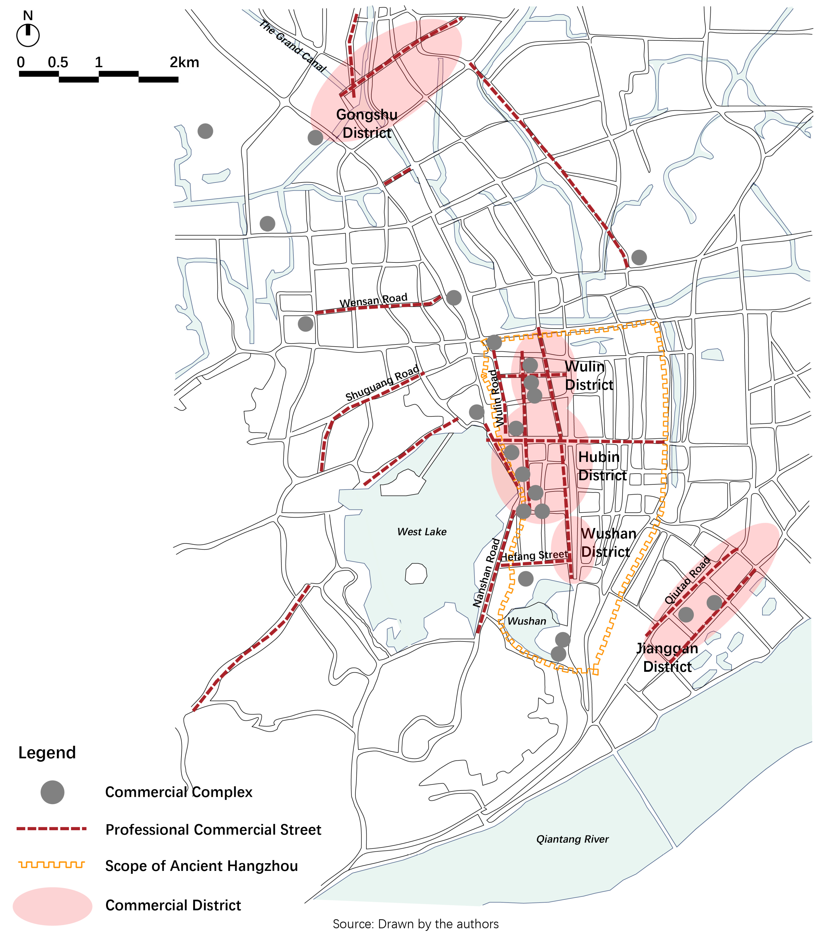
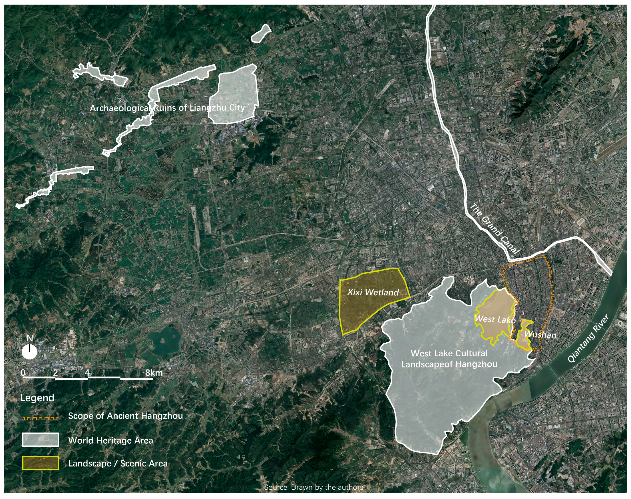
5. Transformation 3: Present Day Hangzhou, 1980s Onwards

Hangzhou’s third transformation occurred in the 1990s, or in the post-reform era since the 2000s [26], when it became one of the top three cities in the Yangtze River Delta region of China. This economic positioning implied that, although Hangzhou’s role was secondary to Shanghai ever since the mid-nineteenth century [31], it still remained the major commercial and cultural center in Southeastern China or the lower reaches of the Yangtze River region. The positioning also forged Hangzhou’s new commercial culture, which added elements of tourism, leisure, and urban heritages and further boosted the urban restructuring of the city.

5.1. New Elements of Commercial Culture

After the founding of the People’s Republic of China in 1949, urban structure and elements of commercial culture of Hangzhou continued to evolve. Apart from the preserved elements, some new elements began to emerge after China’s Reform and Opening-up policy was released in 1978.
The preserved element was the five commercial districts. They inherited Hangzhou’s commercial and cultural heritages as they all had close relationship with one or two of the six marketplaces forged previously, and even the commercial and cultural area originated in the Song dynasty. Among them, Hubin, Wulin, and Wushan commercial districts were formed after the 1980s. With the release and implementation of the ‘Hangzhou Master Plan (2001–2020)’, two new commercial districts, i.e., Gongshu and Jianggan, were added (Table 4).
One new element was professional commercial streets, which severed diverse trade and retail and became new highlights of Hangzhou’s modern commerce. From the 1990s, eighteen special commercial streets, including silk streets, clothing streets, tea culture villages, and so on, were established. Some streets were well known for selling special products, such as Wulin Road featuring women’s dress, Wensan Road featuring digital products, and Qiutao Road featuring home furnishing. Some provided catering, recreation, and refreshment, such as Shuguang Road and Nanshan Road. Tourists could enjoy themselves in some specialty bars and restaurants on these streets. Some others, like Hefang Street near Wushan Scenic Area, were characterized by their culture and profound history, which show the local attraction and national and historical characteristics. The other kind of new element was the mushroomed commercial complexes ever since the 2010s, which contained all kinds of shopping and recreational facilitates. These commercial complexes, as spread across the urban area, attracted many people, and they function as the Song Wazis of the present day. However, they differed from the Wazis in their more even spatial distribution and accessibility (Figure 6).

5.2. Leisure and Heritage Culture

Hangzhou immediately combined its commercial with tourism development, leveraging China’s recognition of the tourism industry as a key driver of economic growth in the 1990s. The city rapidly ascended to become one of China’s most renowned scenic tourist destinations and was labelled as an ‘Oriental City of Leisure’ by the World Leisure Organization in 2006 [60].
To cater to the increasing influx of tourists and visitors, Hangzhou, as a prominent tourist destination and leisure city, strategically expanded its range of commercially valuable scenic areas. In addition to the cultural landscapes and also urban heritages, such as the West Lake and Wushan, the cores of leisure and entertainment in the Song and Qing, some new tourist attractions have emerged during the past two decades. Xixi Wetland, the waterfronts of Grand Canal of Hangzhou Section, and Archaeologic Ruins of Liangzhu City were the three best practices, which exemplified Hangzhou’s alternative path in commercializing its natural and heritage resources to develop its tourist industry and its role as an Oriental City of Leisure, both of which were key factors in shaping the commercial culture.
Xixi Wetland, a natural landscape for ecological recreation, was one of the key elements in pushing Hangzhou’s tourist industry westwards. After the West Lake Cultural Landscape of Hangzhou was nominated as the city’s first World heritage in 2011, the over-1500-year-old Grand Canal as the second in 2014, and Liangzhu prehistoric ruins as the third in 2019, promoting the city’s scenic territory to develop westward and northward (Figure 7).
A series of measures were implemented to enhance national and even international recognition and commodity value of these heritages and resources. The first measure was function transformation. For example, Hangzhou municipal government has undertaken a comprehensive transformation program for the canal, focusing on reducing its emphasis on water transportation and instead integrating leisure and cultural functions to create a vibrant tourist corridor. The second was undertaking various cultural events, like making films, which took the landscape as the movie location, and holding cultural festivals. The third was developing tourist and commercial facilities, such as theme parks, museums designed by world-famous architects, and recreational street blocks, among others. The Wetland Museum, for instance, was designed by the Pritzker Architecture Prize winner (2019) Arata Isozaki and Liangzhu Museum by the Pritzker Architecture Prize winner (2023) David Chipperfield. From one aspect, these measures facilitated the commercializing process and sustainability of the urban heritages and resources. They, from another aspect, enriched the diversity of Hangzhou’s commercial and leisure culture, expanded the city’s tourism and leisure space and, ultimately, reshaped its urban structure.

6. Conclusions

Urban structure formation and transformation are interesting but broad topics, which have been abundantly studied. Quite a few studies focus on the political or institutional factors [3,6,27], economic reasons [4,22,28], cultural and religious dynamics [58,61], or even the natural and cultural landscape factors [24,25,31,33] as the main drivers for the urban restructuring of Chinese cities. Among these studies, various dynastic capitals are abundantly studied as the cases of China’s historical urban structuring and restructuring [6,8,9,14,53,62]. Local Chinese cities, as regarded as supporting roles in this structuring process, remain to be fully studied [52,57]. The dynamic evolution of a once-capital local city, or what we call a multi-identity city, has been rarely studied. In addition, considering the historical and contemporary impact of commerce in shaping various urban forms, it appears that the field of knowledge is still quite incomplete.
Considering the state of the art and deficiencies in current studies, we chose to approach the topic of the urban structuring mechanism by studying Hangzhou, a multi-identity Chinese city, which, we argued, could hardly be studied through either political or economic perspectives. Through data analysis of classic ancient texts, historical maps and painting, critical and latest studies, and POI data, we explored Hangzhou’s internal evolving mechanism and argued that its intricate commercial culture played a pivotal role in continuously shaping and reshaping Hangzhou’s urban spatial structure.
Under a diachronic view, we distinguished Hangzhou’s three major spatial structural transformations. Each was, respectively, driven by the mixed commercial culture with other elementary cultures, such as the civil, leisure, landscape, and industrial. The transforming and sustainability process, in turn, we argued, enriched the city’s complicated commercial culture. Our main findings are summarized as follows (Table 5).
Additionally, many relevant studies on Hangzhou’s urban pattern and structure evolution are qualitative research with no or only raw historic maps and lack a spatial perspective [23,37,56]. By contrast, we introduce and merge the data and information of classic ancient texts and historic maps to display the dynamic transformation of Hangzhou, through graphic analysis of the structuring of the same urban commercial elements, such as the streets, districts, and complexes, generating, inheriting, revitalizing, and reutilizing urban heritages. Through tracing the sequential changes in the same spatial elements on maps, we believe that Hangzhou’s shaping and restructuring process is more clearly displayed than through pure text or individual graphics (Figure 8).
We believe that Hangzhou serves as a prime example of how a city, even in the absence of a dominant political impetus, can continue to evolve and regenerate itself as a complex commercial hub that influences the entire country. Moreover, the city exemplifies the ability to strategically leverage every available resource and element to enhance its commercial strength and foster a vibrant commercial culture. This dynamic approach serves as the vital driving force behind Hangzhou’s ongoing urban development and spatial restructuring. Through a case study of the constant urban structuring and restructuring process of such a city, we wish to trigger more in-depth research on this topic with alternative perspectives and more quantitative data and analysis than this article has applied. Additionally, in terms of the current Liangzhu studies, which are limited within its prehistoric context and period [34,35,36], we also call for further research, which can link this crucial urban heritage, the very origin of a city, and the city’s contemporary urban condition and spatial pattern.

Author Contributions

Conceptualization, K.C. and J.Z.; methodology, K.C., J.Z. and W.X.; formal analysis, K.C., F.W. and W.X.; resources, F.W. and W.X.; writing—original draft preparation, K.C. and J.Z.; writing—review and editing, K.C. and F.W.; visualization, J.Z., F.W. and W.X.; supervision, K.C.; funding acquisition, K.C. All authors have read and agreed to the published version of the manuscript.

Funding

This research was funded by the National Natural Science Foundation of China (grant number 52278082) and the Fundamental Research Funds for the Central Universities.

Data Availability Statement

The data presented in this study are openly available in (https://ctext.org/zhs), reference number [38,40,42,43,44,46], and in (https://www.zhonghuadiancang.com/), reference number [41].

Conflicts of Interest

The authors declare no conflict of interest.

References

  1. Lincoln, T. An Urban History of China; Cambridge University Press: Cambridge, UK, 2021. [Google Scholar]
  2. Barbera, L.; Monaco, A.I.D. Hangzhou. The Contemporary Challenges of a former Capital of Imperial China. L’architettura Delle città. J. Sci. Soc. Ludovico Quaroni 2017, 7, 5–63. [Google Scholar]
  3. de Pee, C.; Lam, J.S.C. Introduction, in Senses of the City: Perceptions of Hang-zhou and Southern Song China; Lam, J.S.C., Lin, S., de Pee, C., Eds.; The Chinese University Press: Hong Kong, China, 2017; pp. xiii–xxv. [Google Scholar]
  4. Skinner, G.W. Introduction: Urban development in imperial China. In The City in Late Imperial China; Skinner, G.W., Ed.; Stanford University Press: Stanford, CA, USA, 1977; pp. 3–32. [Google Scholar]
  5. Shiba, Y. Tyugoku Toshishi; University of Tokyo Press: Tokyo, Japan, 2002. [Google Scholar]
  6. Yang, K. An Institutioanl History of Chinese Ancient Capital Cities; Shanghai People′s Publishing House: Shanghai, China, 2006. [Google Scholar]
  7. Schinz, A. The Magic Squre: Cities in Ancient China; Edition Axel Menges: London, UK, 1996. [Google Scholar]
  8. Xiong, V.C. Capital Cities and Urban Form in Pre-Modern China Luoyang, 1038 BCE to 938 CE.; Routledge: London, UK; New York, NY, USA, 2017. [Google Scholar]
  9. Meng, F. Study on the Form, Structure, and Layout of Song to Qing Dynasty’s Capital Cities; China Social Sciences Press: Beijing, China, 2019. [Google Scholar]
  10. Liu, Q. The Archaeological Discovery and Research of Ancient Chinese Capital; Social Sciences Literature Press: Beijing, China, 2016. [Google Scholar]
  11. Gu, C.; Kesteloot, C. Beijing′s Socio-Spatial Structure in Transition. In Studies in Segregation and Desegregation; Ostendorf, W., Schnell, I., Eds.; Routledge: London, UK, 2002; pp. 27–47. [Google Scholar]
  12. Wang, Y.; Liu, K. Evolution of Urban Socio-Spatial Structure in Modern Times in Xi’an, China. Sustainability 2017, 9, 1935. [Google Scholar] [CrossRef] [Green Version]
  13. Xiong, V.C. Sui-Tang Chang′an: A Study in the Urban History of Medieval China; Michigan Center for Chinese Studies, The University of Michigan: AnArbor, MI, USA, 2000. [Google Scholar]
  14. Seo, T. A Comparative Capital City History of Sui-tang Chang′an and the Estern Asia; Northwest University Press: Xi′an, China, 2019. [Google Scholar]
  15. Lee, K.; Yang, S. A Comparison of Urban Planning in Eastern Asian Capitals during Japanese Colonial Rule: Tokyo, Taipei (1895), Seoul (1910), and Beijing (1936). Sustainability 2023, 15, 4502. [Google Scholar] [CrossRef]
  16. Wang, Y.; Lin, H.; Chen, J.; He, Q.; Liu, Z. Spatio-temporal evolution analysis of spatial form in Nanfeng based on spatial syntax. Ann. GIS 2023, 29, 109–120. [Google Scholar] [CrossRef]
  17. Dai, Z.; Hua, C. Multi-Scale Urban Spatial Evolution Analysis Based on Space Syntax: A Case Study in Modern Yangzhou, China. Int. J. Archit. Environ. Eng. 2019, 13, 345–352. [Google Scholar]
  18. Qin, Q. Analysis Of the Evolution of Urban Form in Modern Hefei City and Its Dynamics Mechanism. Highlights in Science. Eng. Technol. 2023, 51, 175–182. [Google Scholar]
  19. Zhang, J.; Sun, H.; Xu, S.; Aoki, N. Analysis of the Spatial and Temporal Distribution and Reuse of Urban Industrial Heritage: The Case of Tianjin, China. Land 2022, 11, 2273. [Google Scholar] [CrossRef]
  20. Wang, Y.; Du, J.; Kuang, J.; Chen, C.; Li, M.; Wang, J. Two-Scaled Identification of Landscape Character Types and Areas: A Case Study of the Yunnan–Vietnam Railway (Yunnan Section), China. Sustainability 2023, 15, 6173. [Google Scholar] [CrossRef]
  21. Mote, F.W. A millennium of Chinese urban history: Form, time and space concepts in Soochow. Rice Univ. Stud. 1973, 59, 35–65. [Google Scholar]
  22. Southall, A. The City in Time and Space; Cambridge University Press: Cambridge, UK, 1998. [Google Scholar]
  23. Zhou, F. Hangzhou in the Yuan, Ming and Qing Dynasties; Zhejiang People’s Publishing House: Hangzhou, China, 1997. [Google Scholar]
  24. Fu, S. Shan-shui myth and history: The locally planned process of combining the ancient city and West Lake in Hangzhou, 1896–1927. Plan. Perspect. 2016, 31, 363–390. [Google Scholar] [CrossRef]
  25. Duan, X. The Rise of West Lake: A Cultural Landmark in the Song Dynasty; University of Washington Press: Seattle, WA, USA, 2020. [Google Scholar]
  26. Zhu, Q. Post-reform under restructuring in China: The case of Hangzhou 1990–2010. Town Plan. Rev. 2012, 83, 431–455. [Google Scholar]
  27. Zhu, Q. Hangzhou. Cities 2015, 48, 42–54. [Google Scholar]
  28. Wang, L. Urban Space and Tourism in the Social Transformation of Hangzhou; University of California: San Diego, CA, USA, 1997. [Google Scholar]
  29. Wei, Y.D.; Fang, C. Urban expansion and land use restructuring in Hangzhou, China. Asian Geogr. 2003, 22, 61–75. [Google Scholar] [CrossRef]
  30. Fu, S.; Jin, P. Formation of the modern scenic city of Hangzhou: Towards conservation integrated urban planning, 1950s–1990s. Built Herit. 2020, 4, 1–16. [Google Scholar]
  31. Wang, L. Tourism and spatial change in Hangzhou, 1911–1927. In Remaking the Chinese City: Modernity and National Identity, 1900–1950; Esherick, J.W., Ed.; University of Hawai’i Press: Honolulu, HI, USA, 2000; pp. 107–120. [Google Scholar]
  32. Esherick, J.W. Modernity and Nation in the Chinese City. In Remaking the Chinese City: Modernity and National Identity, 1900–1950; Esherick, J.W., Ed.; University of Hawai’i Press: Honolulu, HI, USA, 2000; pp. 1–18. [Google Scholar]
  33. Jia, X. Landscape urbanism: Urban-rural relations in Hangzhou of Southern Song China. In Routledge Handbook of Chinese Architecture; Zhu, J., Wei, C., Hua, L., Eds.; Routledge: London, UK, 2022; pp. 143–158. [Google Scholar]
  34. Yuan, J.; Pan, Y.; Dong, N.; Storozum, M. The rise and fall of the Liangzhu society in the perspective of subsistence economy. Chin. Archaeol. 2022, 22, 145–152. [Google Scholar] [CrossRef]
  35. Zhang, H.; Cheng, H.; Sinha, A.; Spötl, C.; Cai, Y.; Liu, B.; Kathayat, G.; Li, H.; Tian, Y.; Li, Y.; et al. Collapse of the Liangzhu and other Neolithic cultures in the lower Yangtze region in response to climate change. Sci. Adv. 2021, 7, eabi9275. [Google Scholar] [CrossRef] [PubMed]
  36. Zhuang, Y.; Liu, B.; Qin, L. Liangzhu Culture: Society, Belief, and Art in Neolithic China; Routledge: London, UK, 2019. [Google Scholar]
  37. Lam, J.S.C.; Lin, S.; de Pee, C.; Powers, M. Senses of the City: Perceptions of Hangzhou & Southern Song China 1127–1279; The Chinese University of Hong Kong: Hong Kong, China, 2017. [Google Scholar]
  38. Song, M. Gazetteer of Chang′an. Available online: https://ctext.org/wiki.pl?if=gb&res=457201&remap=gb (accessed on 15 June 2023).
  39. Xu, S. Research of Blocks in Two Ancient Capital Cities (Xi’an and Luoyang) of Tang Dynasty; Sanqin Publishing House: Xi’an, China, 2006. [Google Scholar]
  40. Meng, Y. The Dream of Hua in the Eastern Capital. Available online: https://ctext.org/wiki.pl?if=gb&res=712358&remap=gb (accessed on 15 June 2023).
  41. The Old Man of West Lake. Record of Luxuriant Scenery by the Old Man of West Lake. Available online: https://www.zhonghuadiancang.com/tianwendili/10694/ (accessed on 15 June 2023).
  42. Ni, D. A Record of the Capital’s Famous Scenic Spots. Available online: https://ctext.org/wiki.pl?if=gb&res=178091&remap=gb (accessed on 15 June 2023).
  43. Qian, Y. Gazetteer of Lin’an from the Xianchun Reign Period. Available online: https://ctext.org/wiki.pl?if=gb&res=258802&remap=gb (accessed on 15 June 2023).
  44. Zhou, M. Former Matters of Wulin. Available online: https://ctext.org/wiki.pl?if=gb&res=24518&remap=gb (accessed on 15 June 2023).
  45. Wu, Z. Dream of Hangzhou; Zhejiang People’s Publishing House: Hangzhou, China, 2016. [Google Scholar]
  46. Chen, R.; Xia, S. The Government Record of Hangzhou from the Chenghua Reign Period; Available online: https://ctext.org/wiki.pl?if=gb&res=7435959&remap=gb (accessed on 15 June 2023).
  47. Wang, S.; Cui, K.; Wang, K. Study On Supplementary Drawing of Lv Dafang’s ‘Chang′an City Map’ In the Northern Song Dynasty. City Plan. Rev. 2016, 40, 58–64. [Google Scholar]
  48. Cheng, G. Atlas of Chinese History; Chinese Cultural Institute Press: Taibei, China, 1980. [Google Scholar]
  49. Zhu, J.; Pan, J.; Zhu, X. Analysis of Development Features of Dongjing’s Commercial Space in Northern Song Dynasty: Based on Interpretation of Drawing of Riverside Scene at Qingming Festival. City Plan. Rev. 2013, 37, 47–53. [Google Scholar]
  50. Que, W. Hangzhou City and Xihu History in Diagrams; Zhejiang People’s Publishing House: Hangzhou, China, 2000. [Google Scholar]
  51. The Office of Hangzhou Municipal Government. Atlas of Hangzhou; Sinomap Press: Beijing, China, 2004. [Google Scholar]
  52. Huang, J. A Study of Administrative Cities in Jiangnan since Ming Dynasty; Zhonghua Book Company: Beijing, China, 2017. [Google Scholar]
  53. Zhang, X. The Ancient Capitals and Cities in Chinese History; Jiangsu People’s Publishing House: Nanjing, China, 2020. [Google Scholar]
  54. Jiang, Q. A Restoration Study of The Song Version ‘Gazetteer of Lin’an from the Xianchun Reign Period’s Four Capital City Maps; Shanghai Classics Publishing House: Shanghai, China, 2015. [Google Scholar]
  55. Moll-Murate, C. State and Crafts in the Qing Dynasty (1644–1911); Amsterdam University Press: Amsterdam, The Netherlands, 2018. [Google Scholar]
  56. Tang, H. Research on the Early Urban Modernization of Hangzhou: 1896–1927; China Social Sciences Press: Beijing, China, 2013. [Google Scholar]
  57. Bao, W. Urban Study of the Song Dynasty; Zhonghua Book Company: Beijing, China, 2014. [Google Scholar]
  58. Benn, J.A. Tea in China: A Religious and Cultural History; University of Hawai’i Press: Honolulu, HI, USA, 2015. [Google Scholar]
  59. Lai, D.; Wu, J.; Xu, S. An Architecture History of Modern China, Vol 2: Plural Exploration: The Modernization All Over the Country in the Early Republic of China and the Development of China’s Architecture Science; China Building Industry Press: Beijing, China, 2016. [Google Scholar]
  60. Zhuan, T. World Leisure Expo for a Healthier Life. 2011. Available online: http://www.chinadaily.com.cn/regional/2011-09/17/content_13746996.htm (accessed on 1 February 2023).
  61. Wheatley, P. The Origins and Character of the Chinese City; Routledge: Abingdon, VA, USA, 2017. [Google Scholar]
  62. Fu, C.; Cao, W. An Urban History of China; Palgrave Macmillan: Singapore, 2019. [Google Scholar]
Figure 1. Context of the three transformations of Hangzhou.
Sustainability 15 10620 g001
Figure 2. Typical spatial structure of the Li-Fang system (left) and of the Fang-Xiang system (right) [47,49]. Note: The non-English terms in the historic map of the top left corner are the names of the Fangs and houses.
Sustainability 15 10620 g002
Figure 3. A comparison of Tang Chang′an (left) and Southern Song Lin’an (right) [39,43,48]. Note: The non-English terms in the historic map of the top left, right corners, and of the middle, are the names of the palaces, Fangs, streets, rivers, lakes, and houses.
Sustainability 15 10620 g003
Figure 4. The late-Qing Hangzhou’s map (left) and its silk industry districts and scenic spots (right) [50]. Note: The non-English terms in the historic map on the left are the names of the map, streets, rivers, lakes, and houses.
Sustainability 15 10620 g004
Figure 5. The early twentieth century Hangzhou’s map (left) and its old and new marketplaces (right) [50]. Note: The non-English terms in the historic map on the left are the names of the map.
Sustainability 15 10620 g005
Figure 6. Commercial districts, streets, and complexes in contemporary Hangzhou.
Sustainability 15 10620 g006
Figure 7. The distribution of Hangzhou’s natural and heritage resources.
Sustainability 15 10620 g007
Figure 8. Hangzhou’s three transformations.
Sustainability 15 10620 g008
Table 1. Classical ancient data resources.
CityText NameAuthorTime
Tang Chang′anGazetteer of Chang′an [38]Song Minqiu (宋敏求)1076
Research of Blocks in Two Ancient Capital Cities (Xi’an and Luoyang) of Tang Dynasty [39]Xu Son (徐松)1810
Song DongjingThe Dream of Hua in the Eastern Capital [40]Meng Yuanlao (孟元老)1127
Southern Song Lin’anRecord of Luxuriant Scenery by the Old Man of West Lake [41]The Old Man of West Lake (西湖老人)12th century
A Record of the Capital’s Famous Scenic Spots [42]Ni Deweng (耐得翁)1235
Gazetteer of Lin’an from the Xianchun Reign Period [43]Qian Yueyou (潜说友)1268
Former Matters of Wulin [44]Zhou Mi (周密)1290
Dream of Hangzhou [45]Wu Zimu (吴自牧)1334
Ming and Qing HangzhouThe Government Record of Hangzhou from the Chenghua Reign Period [46]Chen Rang (陈让), Xia Shizheng (夏时正)1465–1487
Table 2. Data resources for the urban structuring graphic analysis.
CityHistoric Maps or PaintingBase MapsSatellite Maps
Tang Chang′anLv Dafang (吕大防), Chang′an City Map (长安图), 1080 [47]Cheng Guangyu, Map of Tang Chang′an City [48]/
Xu Son, Map of the Western Capital, ‘Research of Blocks in Two Ancient Capital Cities (Xi’an and Luoyang) of Tang Dynasty’, 1810 [39]
Song DongjingZhang Zeduan (张择端), Riverside Scenes at the Qingming Festival (清明上河图), 1101 [49]//
Southern Song Lin’anQian Yueyou, Map of the Southern Song Capital Lin’an, 1268 [43]Cheng Guangyu, Map of Southern Song Lin’an City [48]/
Qing Hangzhou/Zhejiang Map Bureau, Map of Zhejiang Provincial Capital, 1892 [50]/
Hangzhou in the early twentieth century/Shanghai Bolan Publishing House, Latest Hangzhou City Map: Full Map of West Lake, 1947 [50]/
Contemporary Hangzhou/The Office of Hangzhou Municipal Government, Map of the Eight Districts of Hangzhou [51]Google Earth
Table 3. Comparison between Chang′an and Lin’an.
Tang Chang′anSouthern Song Lin’an
RoleCapital city of the Tang Dynasty and other twelve dynastiesThe Southern Song’s capital city
Urban structureAn enclosed Li-Fang SystemAn open and free Fang-Xiang system
MarketplacesDongshi and XishiThree integrated commercial districts; commercial net stretched all over the city
Recreational placesXichang in the marketplaces and Buddhist monasteriesWazis
Scenic areasBuddhist monasteries; Qujiang Pond and Furong ParkThe West Lake, Wushan and Fenghuang Shan
Table 4. Hangzhou’s commercial districts formed after the 1980s and their relations with the previous marketplaces and urban heritages.
Marketplaces in the Twentieth CenturyCommercial Districts after the 1980sFunctions of the Commercial DistrictsUrban Heritages
Downtown MarketWulin DistrictModern service industries like business, finance, securities, among othersNamed after the name of Hangzhou’s major northern gate in Ming Time, Wulin Gate, which was called Yuhang Gate in the Southern Song
New MarketHubin DistrictLeisure, tourism and upscale shoppingInherited Hangzhou’s prosperous downtown’s business of the early twentieth century
-Wushan DistrictTraditional or historical culture and commerce.A commercial and cultural area originated in the Southern Song Dynasty
Tongshang MarketGongshu DistrictTourism and mass consumptionModern industrial heritage along the Grand Canal
Hushu Market
Jianggan MarketJianggan DistrictSmart commerce and retailAn eponymous district of the early twentieth century market but had different location
Station Market
Table 5. Comparison between the three transformation stages of Hangzhou.
Transformation 1Transformation 2Transformation 3
DurationSouthern Song DynastyFrom Qing through to the Republic of ChinaFrom the 1990s onwards
RoleThe Southern Song’s capitalTop national hub of handcraft manufacturing and commerce; modern industrial and commercial cityProvincial capital of Zhejiang province; top tourist destination; Oriental City of Leisure
Social contextEarly capitalist relation of production sproutedColonization, modernizationChina’s reform and post-reform
ImpetusCommercial and civil cultureCommercial (silk production, modern industry) and leisure (tea, landscape) culturecommercial culture with leisure and heritage culture
TransformationFrom the enclosed to open and free urban structureThe formation of modern marketplaces and the merge of natural landscape and urban areaThe emerging of new commercial elements and expanding of the leisure space
Major commercial and recreational areasThree commercial districts, commercial net and WazisTeahouses and Wushan area; six marketplaces and the West LakeFive marketplaces, eighteen professional commercial streets, hundreds of commercial complexes; three World Heritage and the Xixi Wetland
Changes in urban heritagesThe West LakeThe West Lake; WushanThe West Lake; the Grand Canal; the Liangzhu Prehistoric Site
Disclaimer/Publisher’s Note: The statements, opinions and data contained in all publications are solely those of the individual author(s) and contributor(s) and not of MDPI and/or the editor(s). MDPI and/or the editor(s) disclaim responsibility for any injury to people or property resulting from any ideas, methods, instructions or products referred to in the content.

