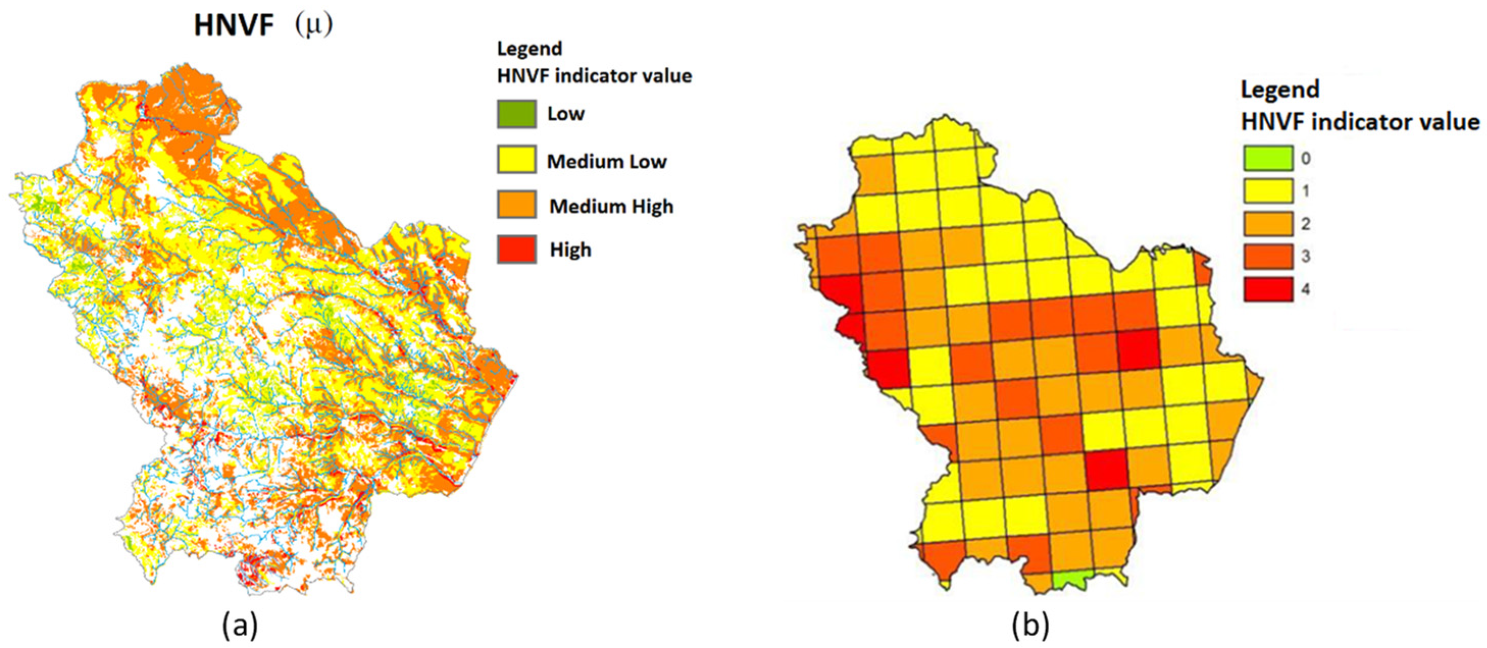
New Technique for Monitoring High Nature Value Farmland (HNVF) in Basilicata
Abstract
1. Introduction
- Developed and stored in a GIS project by using geo-referenced data and maps.
- Based on integrated methods on land cover and cultivation/breeding intensity, taking into account the elements that preserve the distribution of species.
- Dynamic––in order to monitor the spatio-temporal variation of the HNVF areas.
- Able to record and report an increase or a decrease of the HNVF indicators, and, therefore, the level of biodiversity of a specific area.
- -
- Increase protected areas;
- -
- Increase funding to mitigate the negative effects of agriculture on biodiversity and climate;
- -
- Increase and optimize funds that finance environmental and socio-economic objectives.
2. Materials and Methods
2.1. The Study Area
- 1.
- Landscape conformation and structure:
- DEM/DTM computed from remote sensing SAR images (http://rsdi.regione.basilicata.it/; accessed on 5 April 2018).
- Topographic maps (http://rsdi.regione.basilicata.it/; accessed on 5 April 2018).
- Map of coastal areas and dunes covered by vegetation.
- 2.
- Land Use
- Corine Land Cover map (CLC).
- Modis Satellite Images.
- Orthophoto 2012 (http://rsdi.regione.basilicata.it/; accessed on 5 April 2018).
- Map of protected areas: National and Regional Parks, SPAs, SIC, and Habitat map.
- Map of DOP, IGP, and organic crops.
- Vulnerability maps (http://rsdi.regione.basilicata.it/; accessed on 5 April 2018).
- Zoning map (2007–2013 RDPs) dividing the Basilicata territory into 3 homogeneous areas. This provides information on the degree of agricultural specialization, and indirectly provides information on the intensity of external inputs.
- 3.
- Statistical data
- Data from the 6th agricultural census (ISTAT, http://www.istat.it/it/censimentoagricoltura/; accessed on 5 April 2018).
- FDAN Farm accountancy data network.
- RICA Structural data and economic indicators network (Italian CREA).
2.2. Methodology
- -
- To improve the number and accuracy of the land cover classes of the Corine Land Cover map.
- -
- To calculate indicators aimed at monitoring soil and vegetation properties.
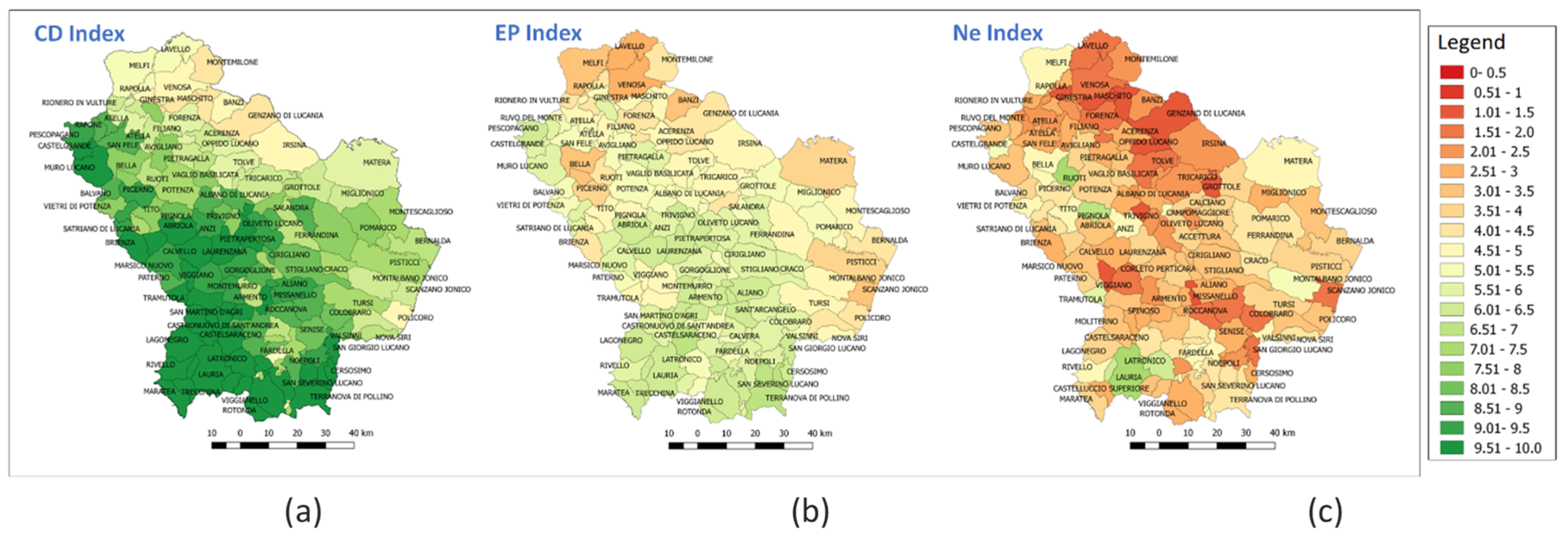
- Crop variability (CD Index).
- Extensive practices (EP Index).
- Presence of natural elements (Index Ne).
Remote Sensing MODIS Images
- Land Cover Type (MCD12Q1): The Version 6 data product provides global land cover types at yearly intervals (2001–2019) and at the spatial resolution of 500 m. Land cover types are: 11 classes of natural vegetation and 3 classes of barren or without vegetation, while the remaining 3 comprise a mixture of different types and/or artificial vegetation, such as croplands, The 2010, 2011, and 2012 land cover maps were used to refine and integrate the CLC map of 2012, while the 2012 orthophoto of the Basilicata region was used to validate the final product. An overall accuracy [36] of about 85% was reached.
- The Aqua/MODIS Land Surface temperature LST dataset (MYD11A2, version 006) starts from 2003. MYD11A2 actually contain the latest improvements to enhance estimation accuracy of LST. The spatial resolution of MYD11A2 is 1 km2.
- MODIS vegetation indices: Normalized difference vegetation index (NDVI) [37] is derived from atmospherically-corrected reflectance in the red and near-infrared wavebands, and it is useful to more effectively characterize the global range of vegetation states and processes.
3. Results and Discussion
4. Conclusions
Author Contributions
Funding
Conflicts of Interest
Appendix A
| lndex | Sub-lndex | Calculation Procedure |
| Cultural Diversity (CD) | CD = 10 + (1 − C1/UAA 10)) + (1 − (C2/UAA 10)) C1 is the crop area > 10% of the UAA In addition to temporary and permanent forage areas. l ≤ CD ≤ 10 | |
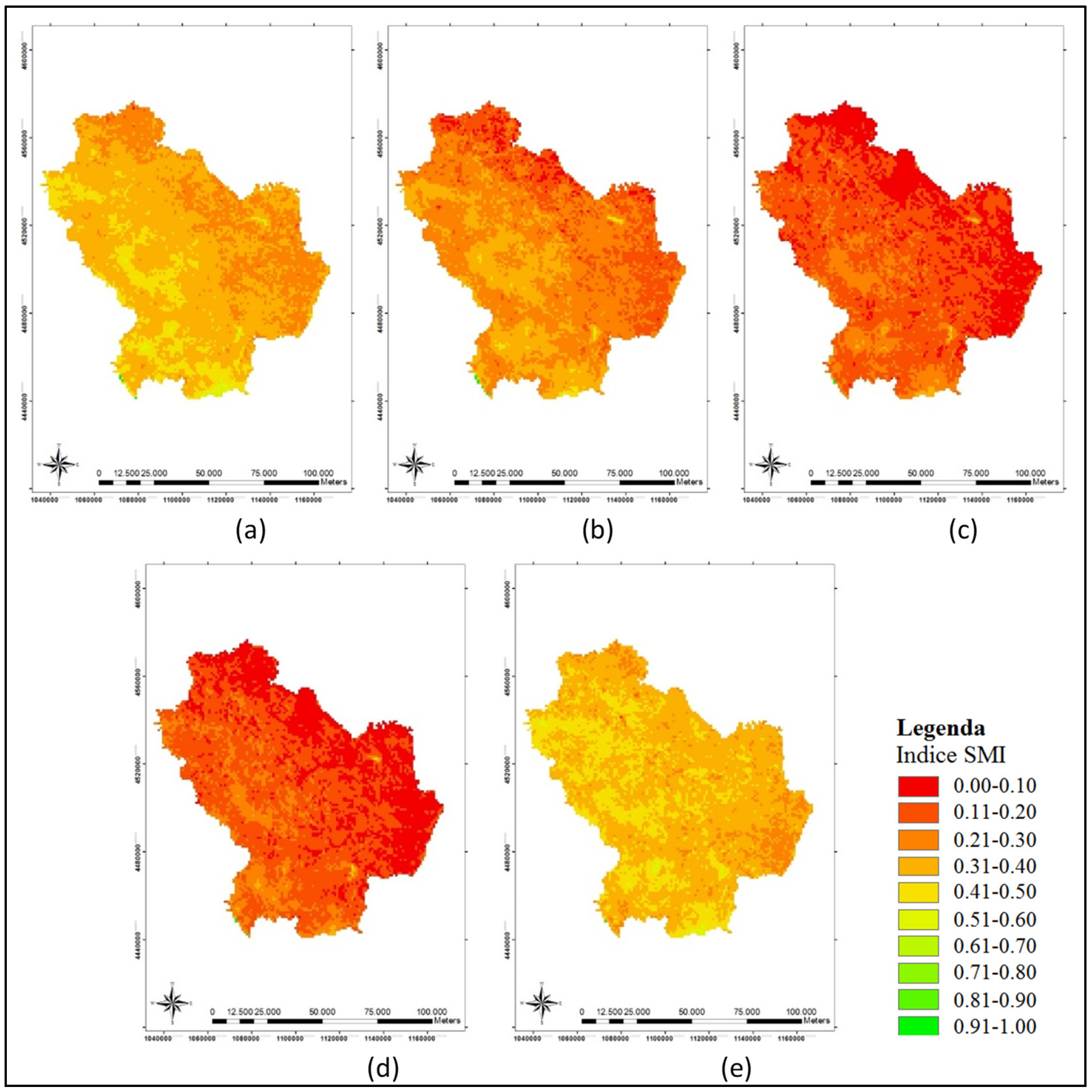
| Extensive practices (EP) | 2.1. Extensive Managed Crops (EMC) (Weight = 2) 2.2. Soil Moisture lndex (SMI) (Weight = 2) 2.3. Extensive Breeding (EB) (Weight = 2) 2.4. Extensive Managed Pastures (EMP) (Weight = 2) 2.5.Nitrogen Surplus (Ns) (Weight = 2) | EMC = (Extensive crops + Fallow)(ha)/UAA(ha) SMI derived/rom EB = 1 − Ʃ(Number of livestock units Surface Temperature and NDVI (MODIS images) LSU Grazing)/UAA(ha) EMP = Permanent Grassland(ha)/UAA(ha) Ns = Ʃ(Nfc − Nrc Rc) Ac(i); c = crop Nf = Suggested fertilization Nr = nutrient content per unit of biomass of the croop c R = Yield of the crop c Ac(ha) = area occupied by crop c in cluster i (The value of each indicator is between 0 and 1) |
| Presence of natural elements (Ne) | 3.1 Hedges and stone wall Length (LSM) (Weight = 2) 3.2 Canals and Streams Length (LC) (Weight = 2) 3.3 Lagoons, wetlands, and ponds (SPLS) (Weight = 2) 3.4 Numbers of Lakes (N) (Weight = 2) 3.5 Number of isolated Trees (Nt) (Weight = 2) | LSM= Hedges and dry-stone wall Length(mt)/UAA(ha) (if 0 < LSM < 50 mt/ha) LSM = LSM/50 (if LSM > SO Mt/ha) LSM = l) LC = Canals and Streams Length (mt)/UAA(ha) (if 0 < LC < 0.1 mt/ ha) LC = LC/0.1 (if LC > 0.1 mt/ ha) LC = 1 SPLS = Lagoons, wetland and ponds surface(ha)/UAA(ha) (if O < SPLS < 0.001 mt/ ha) SPLS = SPLS/0.001 (if SPLS > 0.001 mt/ ha) SPLS = 1 L = Number of lakes/UAA(ha) (if 0 < L < 0.003 mt/ ha) L = L/0.003 (if SPLS > 0.003 mt/ ha) L = 1 Nt = Number of isolated trees/UAA(ha) (if Nt > 1) Nt = 1 (The value of each indicator is between O and 1) |
Appendix B
| Municipalities |
| ALIANO |
| BALVANO |
| CASTELLUCCIO INFERIORE |
| CERSOSIMO |
| EPISCOPIA |
| GUARDIA PERTICARA |
| PATERNO |
| PIETRAPERTOSA |
| RAPONE |
| SALANDRA |
| SAN GIORGIO LUCANO |
| TRECCHINA |
| VALSINNI |
References
- European Evaluation Network for Rural Development. Guidance Document to the Member States on the Application of the HNV Impact Indicator; European Evaluation Network for Rural Development: Brussels, Belgium, 2008. [Google Scholar]
- European Communities. Guidance document. In The Application of the High Nature Value Impact Indicator; Programming Period 2007–2003; European Commission: Luxembourg, 2009. [Google Scholar]
- European Evaluation Network for Rural Development. Working Paper on Approaches for Assessing the Impacts of the RDPs in the Context of Multiple Intervening Factors; European Evaluation Network for Rural Development: Brussels, Belgium, 2010. [Google Scholar]
- De Lucia, S. Approccio All’identificazione Delle Aree ad Alto Valore Naturale; ISPRA: Roma, Italy, 2013.
- Morelli, F.; Jerzak, L.; Tryjanowski, P. Birds as useful indicators of high nature value (HNV) farmland in Central Italy. Ecol. Indic. 2014, 38, 236–242. [Google Scholar] [CrossRef]
- Andersen, E.; Baldock, D.; Bennet, H.; Beaufoy, G.; Bignal, E.; Brower, F.; Elbersen, B.; Eiden, G.; Godeschalk, F.; Jones, G.; et al. Developing a high nature value farming area indicator. In Report for the European Environment Agency, Copenhagen; European Environment Agency: Copenhagen, Denmark, 2003. [Google Scholar]
- European Union. Council Regulation (EC) No 1698/2005 of 20 September 2005 on support for rural development by the European Agricultural Fund for Rural Development (EAFRD). Off. J. Eur. Union 2005, 277, 21. [Google Scholar]
- European Council. Council Decision of 20 February 2006 on Community Strategic Guidelines for Rural Development (Programming Period 2007 to 2013) (2006/144/EC); European Council: Brussels, Belgium, 2006.
- European Commission. Agri-Environment Measures Overview on General Principles; Types of Measures, and Application; European Commission: Luxembourg, 2005.
- European Commission. Preparing the Assessment of HNV Farming in RDPs 2014–2020: Practices and Solutions; Good Practice Workshop, Bonn 7–8 June 2016; European Commission: Brussels, Belgium, 2016.
- European Commission. Farming for Natura 2000. In Guidance on How to Support Natura 2000 Farming Systems to Achieve Conservation Objectives, Based on Member States Good Practice Experiences; EU: Luxembourg, 2018. Available online: https://ec.europa.eu/environment/nature/natura2000/management/docs/ES.pdf (accessed on 5 April 2018).
- European Commission. A Farm to Fork Strategy for a Fair, Healthy and Environmentally-Friendly Food System; COM (2020) 381 Final; European Commission: Brussels, Belgium, 2020.
- Lomba, A.; Alves, P.; Jongman, R.H.; McCracken, D.I. Reconciling nature conservation and traditional farming practices: A spatially explicit framework to assess the extent of High Nature Value farmlands in the European countryside. Ecol. Evol. 2015, 5, 1031–1044. [Google Scholar] [CrossRef] [PubMed]
- Bozzo, F.; Fucilli, V.; Petrontino, A.; Girone, S. Identification of High Nature Value Farmland: A methodological proposal. Ital. Rev. Agric. Econ. 2019, 74, 29–41. [Google Scholar] [CrossRef]
- Pe’Er, G.; Bonn, A.; Bruelheide, H.; Dieker, P.; Eisenhauer, N.; Feindt, P.H.; Hagedorn, G.; Hansjürgens, B.; Herzon, I.; Lomba, B.; et al. Action needed for the EU Common Agricultural Policy to address sustainability challenges. People Nat. 2021, 2, 305–316. [Google Scholar] [CrossRef] [PubMed]
- Ribeiro, P.F.; Nunes, L.C.; Beja, P.; Reino, L.; Santana, J.; Moreira, F.; Santos, J.L. A Spatially Explicit Choice Model to Assess the Impact of Conservation Policy on High Nature Value Farming Systems. Ecol. Econ. 2018, 145, 331–338. [Google Scholar] [CrossRef]
- Fiorentino, C.; Donvito, A.R.; D’Antonio, P.; Lopinto, S. Experimental Methodology for Prescription Maps of Variable Rate Nitrogenous Fertilizers on Cereal Crops. Lect. Notes Civ. Eng. 2020, 67, 863–887. [Google Scholar]
- Concepción, E.D.; Aneva, I.; Jay, M.; Lukanov, S.; Marsden, K.; Moreno, G.; Oppermann, R.; Pardo, A.; Piskol, S.; Rolo, V.; et al. Optimizing biodiversity gain of European agriculture through regional targeting and adaptive management of conservation tools. Biol. Conserv. 2020, 241, 108384. [Google Scholar] [CrossRef]
- Garibaldi, L.A.; Oddi, F.J.; Miguez, F.E.; Bartomeus, I.; Orr, M.C.; Jobbágy, E.G.; Kremen, C.; Schulte, L.A.; Hughes, A.C.; Bagnato, C.; et al. Working landscapes need at least 20% native habitat. Conserv. Lett. 2021, 14, e12773. [Google Scholar] [CrossRef]
- Tarjuelo, R.; Concepción, E.D.; Guerrero, I.; Carricondo, A.; Cortés, Y.; Díaz, M. Agri-environment scheme prescriptions and landscape features affect taxonomic and functional diversity of farmland birds. Agric. Ecosyst. Environ. 2021, 315, 107444. [Google Scholar] [CrossRef]
- Plieninger, T.; Torralba, M.; Hartel, T.; Fagerholm, N. Perceived ecosystem services synergies, trade-offs, and bundles in European high nature value farming landscapes. Landsc. Ecol. 2019, 34, 1565–1581. [Google Scholar] [CrossRef]
- Oppermann, R.; Beaufoy, G.; Jones, G. High Nature Value Farming in Europe; Verlag Regionalkultur: Ubstadt-Weiher, Germany, 2012. [Google Scholar]
- Elsharkawy, M.M.; Sheta, A.E.A.S.; D’Antonio, P.; Abdelwahed, M.S.; Scopa, A. Tool for the Establishment of Agro-Management Zones Using GIS Techniques for Precision Farming in Egypt. Sustainability 2022, 14, 5437. [Google Scholar] [CrossRef]
- Gardi, C.; Visioli, G.; Conti, F.D.; Scotti, M.; Menta, C.; Bodini, A. High Nature Value Farmland: Assessment of Soil Organic Carbon in Europe. Front. Environ. Sci. 2016, 4, 47. [Google Scholar] [CrossRef]
- Fadl, M.E.; Jalhoum, M.E.M.; AbdelRahman, M.A.E.; Ali, E.A.; Zahra, W.R.; Abuzaid, A.S.; Fiorentino, C.; D’antonio, P.; Belal, A.A.; Scopa, A. Soil Salinity Assessing and Mapping Using Several Statistical and Distribution Techniques in Arid and Semi-Arid Ecosystems, Egypt. Agronomy 2023, 13, 583. [Google Scholar] [CrossRef]
- Bernués, A.; Tello-García, E.; Rodríguez-Ortega, T.; Ripoll-Bosch, R.; Casasús, I. Agricultural practices, ecosystem services and sustainability in High Nature Value farmland: Unraveling the perceptions of farmers and nonfarmers. Land Use Policy 2016, 59, 130–142. [Google Scholar] [CrossRef]
- Lomba, A.; Moreira, F.; Klimek, S.; Jongman, R.H.; Sullivan, C.; Moran, J.; Poux, X.; Honrado, J.P.; Pinto-Correia, T.; Plieninger, T. Back to the future: Rethinking socioecological systems underlying high nature value farmlands. Front. Ecol. Environ. 2020, 18, 36–42. [Google Scholar] [CrossRef]
- EIP-AGRI. Focus Group Sustainable High Nature Value (HNV) Farming; Final Report; EIP-AGRI: Luxembourg, 2016; pp. 1–56. [Google Scholar]
- QGIS. Available online: https://qgis.org/en/site/forusers/download.html (accessed on 5 April 2018).
- Moderate Resolution Imaging Spectroradiometer (MODIS). Available online: https://modis.gsfc.nasa.gov/data/ (accessed on 5 April 2018).
- Lazzerini, G.; Dibari, C.; Merante, P.; Pacini, G.C.; Moschini, V.; Migliorini, P.; Vazzana, C. Identification and mapping the high nature value farmland by the comparison of a combined and species approaches in Tuscany, Italy. Ital. J. Agron. 2015, 10, 132–143. [Google Scholar] [CrossRef]
- Paracchini, M.L.; Terres, J.M.; Petersen, J.E.; Hoogeveen, Y. Background Document on the Methodology for Mapping High Nature Value Farmland in EU27; EU JRC: Brussels, Belgium, 2006. [Google Scholar]
- Paracchini, M.L.; Petersen, J.; Hoogeveen, Y.; Bamps, C.; Burfield, I.; Van Swaay, C. High Nature Value Farmland in Europe-An Estimate of the Distribution Patterns on the Basis of Land Cover and Biodiversity Data; EUR 23480 EN–Joint Research Centre–Institute for Environment and Sustainability Luxembourg: Office for Official Publications of the European Communities: Luxembourg, 2008. [Google Scholar]
- Pointereau, P.; Paracchini, M.L.; Terres, J.-M.; Jiguet, F.; Bas, Y.; Biala, K. Identification of High Nature Value farmland in France through Statistical Information and Farm Practice Surveys; EUR 22786 EN; Office for Official Publications of the European Communities: Luxembourg, 2007. [Google Scholar]
- Pointereau, P.; Doxa, A.; Coulon, F.; Jiguet, F.; Paracchini, M.L. Analysis of Spatial and Temporal Variations of High Nature Value Farmland and Links with Changes in Bird Populations: A Study on France; EUR 24299 EN; Office for Official Publications of the European Communities: Luxembourg, 2010. [Google Scholar]
- Duda, R.O.; Hart, P.E.; Stork, D.G. Pattern Classification, 2nd ed.; John Wiley & Sons: New York, NY, USA, 2000. [Google Scholar]
- Rouse, J.W.; Haas, R.H.; Schell, J.A.; Deering, D.W. Monitoring vegetation systems in the Great Plains with ERTS. NASA Spec. Publ. 1973, 351, 309–317. [Google Scholar]
- Parida, B.R.; Collado, W.B.; Borah, R.; Hazarika, M.K.; Samarakoon, L. Detecting Drought-Prone Areas of Rice Agriculture Using a MODIS-Derived Soil Moisture Index. GIsci. Remote Sens. 2008, 45, 109–129. [Google Scholar] [CrossRef]
- Acebes, P.; Pereira, D.; Oñate, J.J. Towards the identification and assessment of HNV Dehesas: A meso-scale approach. Agrofor. Syst. 2016, 90, 7–22. [Google Scholar] [CrossRef]
- Brunbjerg, A.K.; Bladta, J.; Brinkc, M.; Fredshavnd, J.; Mikkelsena, P.; Moeslunda, J.E.; Nygaarda, B.; Skova, F.; Ejrnæsaa, R. Development and implementation of a high nature value (HNV) farming indicator for Denmark. Ecol. Indic. 2016, 61, 274–281. [Google Scholar] [CrossRef]
- Almeida, M.; Guerra, C.; Pinto-Correia, T. Unfolding relations between land cover and farm management: High nature value assessment in complex silvo-pastoral systems. Geogr. Tidsskr.-Dan. J. Geogr. 2013, 113, 97–108. [Google Scholar] [CrossRef]
- Galdenzi, D.; Pesaresi, S.; Casavecchia, S.; Zivkovic, L.; Biondi, E. The phytosociological and syndynamical mapping for the identification of High Nature Value Farmland. Plant Sociol. 2012, 49, 59–69. [Google Scholar]
- Trisorio, A.; De Natale, F.; Pignatti, G. Le Aree Agricole ad Alto Valore Naturale in Italia: Una Stima a Livello Regionale. Agriregionieuropa, 33. 2013. Available online: www.agriregionieuropa.it (accessed on 5 April 2018).
- Campedelli, T.; Calvi, G.; Rossi, P.; Trisorio, A.; Florenzano, G.T. The role of biodiversity data in High Nature Value Farmland areas identification process: A case study in Mediterranean agrosystems. J. Nat. Conserv. 2018, 46, 66–78. [Google Scholar] [CrossRef]
- ISPRA. Aree Agricole ad alto Valore Naturale: Dall’individuazione Alla Gestione. Manuali e Linee Guida: 62/2010. 2017. Available online: https://www.isprambiente.gov.it/it/pubblicazioni/manuali-e-linee-guida/aree-agricole-ad-alto-valore-naturale (accessed on 5 April 2018).
- Cozzi, M.; Giglio, P.; Romano, S. Spatial Analysis of HNVF Areas in the Region of Basilicata. In Proceedings of the XVIII-IPSAPA Interdisciplinary Scientific Conference, Catania, Italy, 3 July 2014. Special Issue 2/2014. [Google Scholar]
- Italian Regulation. Ministero Delle Politiche Agricole e Forestali. Decreto 19 Aprile 1999. Approvazione del Codice di Buona Pratica Agricola. 1999. Available online: http://gazzette.comune.jesi.an.it/102-99/suppl86.htm (accessed on 5 April 2018).
- XVIII-IPSAPA Interdisciplinary Scientific Conference. Special Issue 2/2014. Available online: https://www.researchgate.net/publication/277308366_ANALISI_SPAZIALE_DELLE_AREE_HNVF_NEL_TERRITORIO_LUCANOSpatial_Analysis_of_HNVF_Areas_in_the_Region_of_Basilicata (accessed on 5 April 2018).
- Tarjuelo, R.; Morales, M.B.; Traba, J.; Delgado, M.P. Are Species Coexistence Areas a Good Option for Conservation Management? Applications from Fine Scale Modelling in Two Steppe Birds. PLoS ONE 2014, 9, e87847. [Google Scholar] [CrossRef]
- Clark, S. Organic Farming and Climate Change: The Need for Innovation. Sustainability 2020, 12, 7012. [Google Scholar] [CrossRef]
Disclaimer/Publisher’s Note: The statements, opinions and data contained in all publications are solely those of the individual author(s) and contributor(s) and not of MDPI and/or the editor(s). MDPI and/or the editor(s) disclaim responsibility for any injury to people or property resulting from any ideas, methods, instructions or products referred to in the content. |
© 2023 by the authors. Licensee MDPI, Basel, Switzerland. This article is an open access article distributed under the terms and conditions of the Creative Commons Attribution (CC BY) license (https://creativecommons.org/licenses/by/4.0/).
Share and Cite
Fiorentino, C.; D’Antonio, P.; Toscano, F.; Donvito, A.; Modugno, F. New Technique for Monitoring High Nature Value Farmland (HNVF) in Basilicata. Sustainability 2023, 15, 8377. https://doi.org/10.3390/su15108377
Fiorentino C, D’Antonio P, Toscano F, Donvito A, Modugno F. New Technique for Monitoring High Nature Value Farmland (HNVF) in Basilicata. Sustainability. 2023; 15(10):8377. https://doi.org/10.3390/su15108377
Chicago/Turabian StyleFiorentino, Costanza, Paola D’Antonio, Francesco Toscano, Angelo Donvito, and Felice Modugno. 2023. "New Technique for Monitoring High Nature Value Farmland (HNVF) in Basilicata" Sustainability 15, no. 10: 8377. https://doi.org/10.3390/su15108377
APA StyleFiorentino, C., D’Antonio, P., Toscano, F., Donvito, A., & Modugno, F. (2023). New Technique for Monitoring High Nature Value Farmland (HNVF) in Basilicata. Sustainability, 15(10), 8377. https://doi.org/10.3390/su15108377


