1. Introduction
The research question answered in this paper is testing a combination of methods that allow for the optimization of a network through the connection of fast to slow mobility routes.
These routes mend the relationship between the infrastructure networks and the places of interest in the landscape while respecting morphological adaptability.
The chosen case study, which tests the requirements of the methodology, is made by the territories crossed by a railway line that has recently been decommissioned. The displacement of a railway line creates a possibility of transformation of the territory both locally, with a natural evolution of the track in a greenway, and at the territorial level because it generates a network of possible connections with the surrounding areas. The environment in which this work has been developed is a Fragile Territory [
1], a type of area far from large urban agglomerations and dotted with small and medium centers whose connections with the rest of the national territory are problematic.
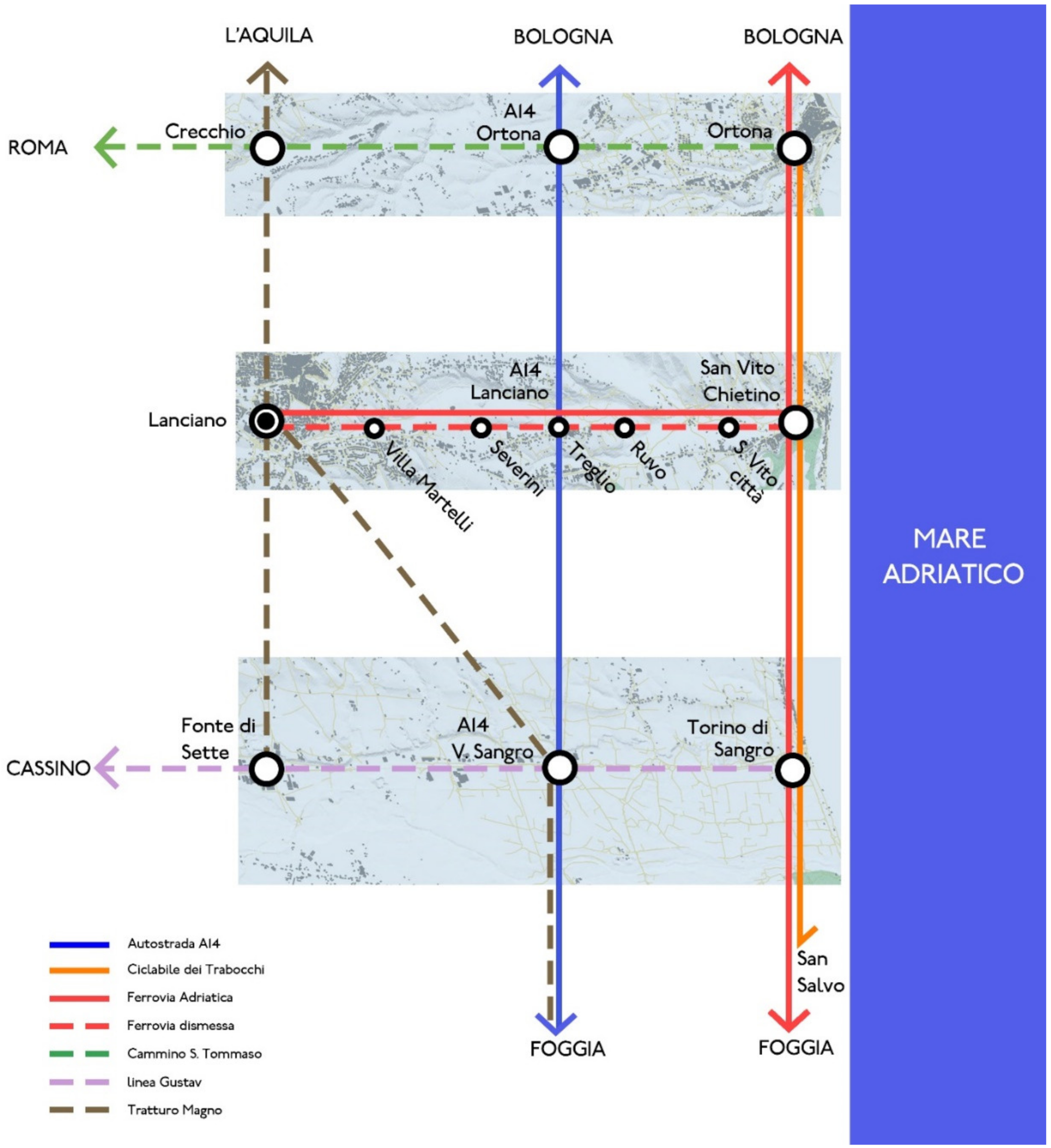
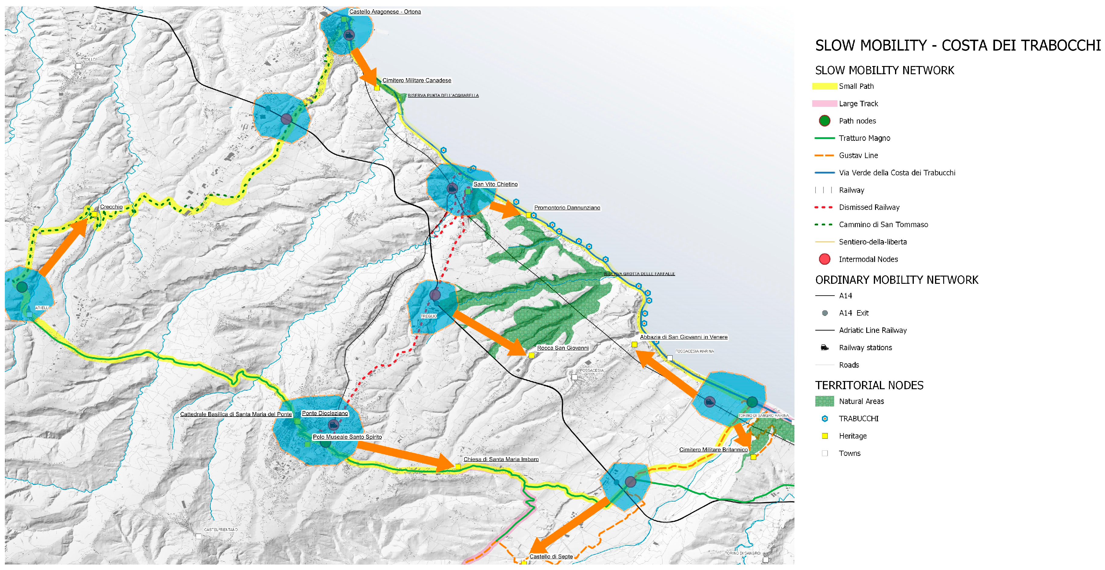
At the Department of Architecture and Urban Studies of the Politecnico di Milano, a project has been explored in depth that seeks to systematize the long and fast networks and the short and slow networks that traverse these particular areas (
Figure 1).
The scientific literature analysing the evaluation of routes within urban environments is far fewer in number than those analysing routes between different urban centres. One of the aims of this work is to fill the void of studies in this specific approach to the territory, where new infrastructures such as greenways have changed the previous spatial configuration. This request falls within the United Nations Sustainable Development Goals (SDG). Specifically, it deals with SDG 3 (Good Health), 9 (Industry, Innovation and Infrastructure), and 11 (Sustainable City and Communities).
The greenways in Italy have been widely analyzed as a singularity in territory [
2], but their relationship with landscape in terms of quantitative value analysis is rarely considered. Among the most frequently used analysis methodologies are multicriteria [
3], but the landscape morphology has been considered as a singularity, not as a whole. The Contingent Valuation Method [
4] analyses slow mobility paths, but spatial considerations are also included. [
5] deals with historic paths, but the scale of analysis is too large to achieve a detailed path as required. [
6], in which the most tourism-relevant coastal municipalities are reconciled with the Alcantara river valley, highlights only the social and economic attributes and summarily indicates the development paths.
It is worthy of mention a work [
7] in which a methodology for route selection is researched based on the evaluation of a traditional series of interviews within a park in Australia. Another work [
8] deals with the selection of tourist routes and is based on a series of interviews within areas with a strong tourist vocation in Norway. The originality of this work is the three-dimensional multiscalar approach, which allows an in-depth analysis of the territory. The works cited in the literature review fail to provide analyses at urban detail scales, but instead limit themselves to very large-scale analyses.
The integration between the different networks is based on the definition of intermodal nodes, which are portals through which it is possible to improve territory accessibility and its fruition. Nodes, as considered in this work, are not limited to their role as intermodal connections but are rooted in the landscape and heritage elements in their vicinity. An area of influence is thus formed around the node itself that embraces a special ecosystem connected to it.
This work has identified which networks need to be strengthened by identifying the nodes to be optimized to guarantee a more balanced use of the territories. An additional element for the definition of these networks is the presence of attractors on the territory, both as urban centers and as elements of historical, cultural, or landscape heritage. Digital and analogue customized strategies have been developed to connect the needs in an organic system of nodes and networks, which constitute a basis for the conscious design of the mobility of the territory.
2. Case Study and Context Analysis
The case study that generated the research question explained above is the Costa dei Trabucchi in Abruzzo, Italy. This area extends for about 42 km along the Adriatic coast between the towns of Ortona and San Salvo, and 32 km in a perpendicular direction to the coast. The long and fast networks crossing this area are the A14 Adriatic Motorway, the National Road 16 “Adriatica”, and the Adriatic Railway. The slow and short networks within the area are the San Vito Chietino–Lanciano railway line and the major roads that run along with the valley floors of the Sangro and Trigno rivers. Particularly significant in terms of traffic are all the road links between the anthropized centers of the nearby hills and their counterparts along the coast characterized by seasonal flows. These links are oversized in the winter period and undersized during the summer season when a large influx of tourists reduces the efficiency of the transport system.
Among the slow and short networks, it is essential to investigate the effects of a modification in the railway track along the coast that has significantly changed the territory’s assets. Parallel to the decommissioning of the old site in 2005, the Province of Chieti launched the project for its reconversion into a greenway called “Via Verde della Costa dei Trabocchi”, shortened to Via Verde in memory of particular fishing structures, the trabocchi [
9,
10] that characterize that stretch of the Abruzzo coast. The Via Verde is part of the Adriatic cycleway project, one of the ten national tourist cycleways promoted by the Ministry of Infrastructure and Transport, which, once completed, will be a 700 km route of national importance from Venice to the Gargano. Several survey campaigns were undertaken between 2018 and 2019 to census the progressive systematization of the bicycle structure.
This territory is already crossed by existing networks of slow mobility, including a series of historical routes whose traces are partly lost. These are, respectively, the Tratturo Magno, the “Cammino di San Tommaso”, the Gustav Line and the Sentiero della Libertà. The Tratturo Magno [
11] is an ancient road travelled by the herds since Roman times, which was used to move the flocks in spring from Abruzzo to Puglia and in autumn in the opposite direction. The Cammino di San Tommaso [
12] is a cultural, naturalistic, and spiritual itinerary that connects the city of Rome with the Basilica of St. Peter in Ortona through the remembrance of the footsteps of St. Bridget of Sweden, between 1365 and 1368 came to Ortona following the revelation of the presence of the bones of St. Thomas in the Cathedral of the city. The itinerary along the “Gustav Line” [
13] is a route that crosses Central Italy retracing the memory of the defensive line of the Second World War that, between the last months of 1943 and the first months of 1944, was used by the Germans to stop the advance of the Allies towards the north. The route starts from the British Military Cemetery at Torino di Sangro, joining the Sangro river’s mouth and following its course up to the Garigliano river ending near Gaeta. The last path analyzed is the “Sentiero della Libertà” [
14,
15] which joins Badia Morronese near Sulmona with Casoli. It was the escape route of thousands of allied prisoners and young Italians (among which Carlo Azeglio Ciampi) from the prison camps who were fighting for the liberation of Italy, divided by the “Gustav Line” after the armistice of 8 September 1943.
The territory target of this research work has a peculiar orographic configuration because it is located in the middle Adriatic area characterized by deep river valleys transversal to the coastline. Some hills reach the coast between one valley and the next, leaving a narrow stretch to access the sea. To the forehead of the orographic situation, the urban centers are subdivided into an original anthropic aggregate situated on a hill and a portion of the recently built waterfront area. The vehicular flows try to accommodate this dichotomy in the occupation of the territory, growing to become unmanageable during the summer season to dry up almost entirely in winter.
3. Methodology
The choice of a single paradigmatic case study to evaluate the method is based on the need to analyse an edge context where very scarce territorial data are available, except for the coast. Data from major social networks and open data, in general, are practically absent in the case study area. Particularly significant is the almost complete lack of meaningful Strava heatmap data; it is, therefore, difficult to select preferred routes in alternative case studies that answer the initial research question. The strategy behind this research aims to define a methodology that can be applied to similar territories, where it is important to reconnect the long/fast networks with the slow ones in the territory through the definition of slow mobility routes that also pass by intermodal nodes.
The strategy to identify these nodes is subordinated to the identification of both slow and ordinary mobility networks. The recognition and positioning of long and fast networks was the first simple step because the territory lacks them, except for those parallel to the coast and those along the valleys. The slow mobility networks were instead identified through patient survey work—where possible—and archival work, when their traces were disappearing or had disappeared altogether. The family of nodes was generated from the intersection of these networks.
A series of methods were applied to seek the best paths starting from the environmental, territorial, and orographic conditions already detailed in the previous section. For this reconnection purpose, several digital and analogue methods were tested to analyze and optimize the communication flows between the elements of the territory. These methods are based on a bottom-up approach because they start from the application of a specific case study. In-depth knowledge of the case study generates the question that guides the direction of the strategy. Analogue methods allow for a thorough understanding of the routes, networks, and heritage elements in the area. The digital methods identified are applicable to homogeneous cases due to both the multiscalarity and the flexibility inherent in programmable digital ecosystems. Starting from the same code, in fact, it is possible to obtain different results from different spatial inputs within the set parameters.
The flow with which the methodology operates is structured in two customized steps, each of which is endowed with the reference works where procedures are explained in detail:
- (1)
Quality Index Machine Learning—The use of Image Segmentation to define the quality of paths through a photographic survey applied to artificial intelligence [
16,
17,
18].
- (2)
NURBS + DTM—The use of the 3D NURBS model to define the territory, which is generated by a proprietary algorithm instead of the traditional triangular model. This technique allows slow paths to be defined and optimised with respect to the morphology of the territory [
19,
20,
21,
22].
Once the routes and their crossings have been identified through the previous two steps, the final aim is to create a slow mobility network between the infrastructural nodes (stations, motorway toll booths, and service areas), hamlets, and also considering other historical geographic elements of interest (intersections of natural, cultural, and heritage routes, such as rivers, sheep tracks, or other routes of historical relevance).
3.1. Quality Index ML Method
The first method, called Quality Index ML, integrates different tools to assess the quality of the landscape along the routes through it. The objective of this analysis is to identify the route that best optimises the enjoyment of the traversed landscape.
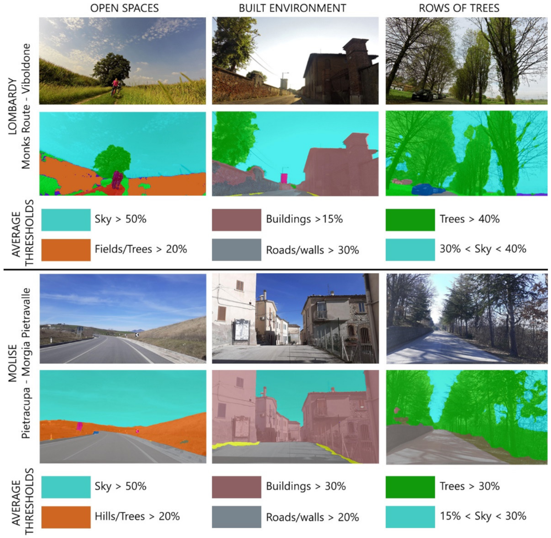
The tools that are used were selected with two different perspectives of the analysis in mind. The primary tool used belongs to the digital ecosystem of Machine Learning (ML) to assess the quality of the paths crossed. This methodology, starting from a photographic survey done at human height, analyses the elements present in a single photo with an automatic procedure. For each element surveyed, a perimeter is elaborated with Image Segmentation technology. This digital tool allows the identification of a perimeter, which corresponds to a percentage of occupation of the element on the entire photo frame. The sum of the elements of a single photo frames it within a broader classification that groups all the shots with homogeneous characteristics. Each class created with this procedure becomes an environment that characterizes that particular area of the territory. The first experimentation identified three different types of areas differentiated by visual obstacles on the sides of the path, as shown in
Figure 2. There are trees or anthropic barriers on two sides, on one only, or none.
The ML methodology applied in the second case study is integrated with the zenith point of view, derived from GIS mapping the already described human eye level. With this integration, additional data are added that would be unavailable with the ML methodology. Thus, it overcomes the limitations of the analysis of the elements that fall within the frame with the addition of landscape elements present on the territory and surveyed through GIS databases but are also invisible only along the path. With this methodology, three different environments have been identified: a village, a row of trees, and an open space.
To demonstrate the flexibility of the methodology, it was applied to the comparison of two additional case studies. The first is in Lombardy, where there is an abundance of data and a flat territory. The second is in Molise, where, on the other hand, the spatial conditions and scarcity of data are similar to the main case study. The one in the Lombardy region refers to the Monks Route, a slow route that connects the Milan city center to Corte Sant’Andrea by crossing the Po Valley in the northwest to southeast direction following the Lambro River valley. The second is located in the “Parco Cenozoico delle Morge” in Molise. The landscape where Morge park is located straddles the valley floor of the Biferno, which crosses the Molise Region, and the Trigno river, which separates it from the Abruzzo Region.
The data derived from GIS are present in the Lombardy area, completely missing in the Molise one. The validation of this methodology was carried out precisely by the consistency between GIS data and those derived from the ML methodology alone.
The Quality Index ML was preliminarily applied in the Lombardy and Molise areas to test its effectiveness. This methodology was eventually applied to a sampling of all the roads in the case study in order to identify those that are most pleasant to drive on. Subsequently, it was the basis for the definition of the pathways in this work in the main case study.
3.2. NURBS + DTM Method
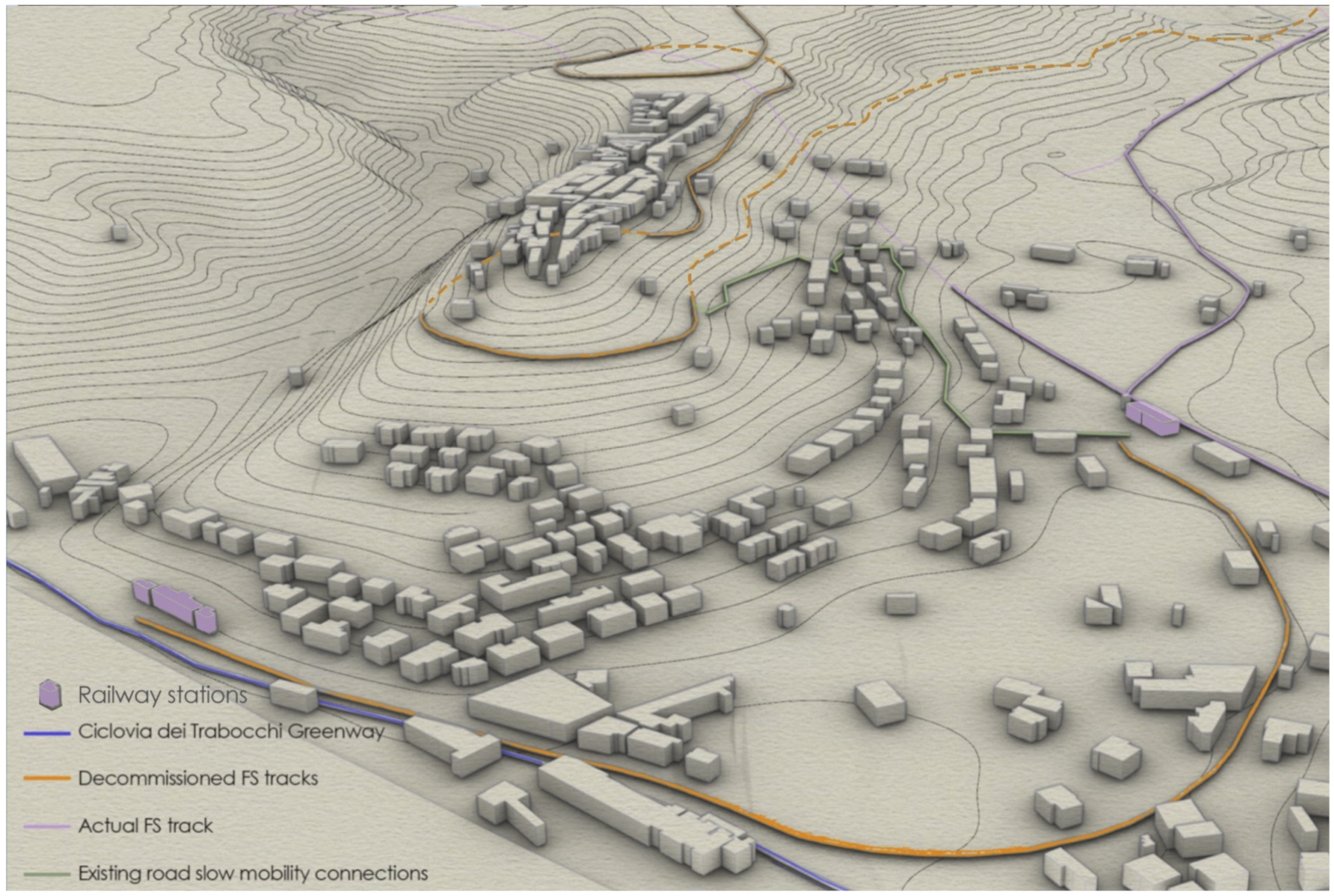
Once the routes have been identified using the methodology explained in the previous section, the intersections between the routes will be identified. Around these, catchment areas were identified that were formed by the intermodal connections and the village and heritage system. The NURBS + DTM method has been applied to slow mobility nodes and routes in well-defined sample areas of the case study, as the San Vito Chietino area shown in
Figure 3.
The objective of this analysis is to identify an optimised slow mobility route that crosses the node of interest. It aims to overcome the computational problem that prevents obtaining high-precision three-dimensional analyses at the spatial scale. These analyses would be expensive in terms of calculation time if applied to large areas. The methodology developed is based on a parametric and multiscalar approach that, starting from the ad hoc algorithm, allows for the creation of a three-dimensional NURBS model of the territory starting from the easily obtainable data from a georeferenced public database. The flexibility of the method produces a series of analyses wherein the accuracy varies depending on the quality of the input data. In the study area, the accuracy of interpolation at the ground level of the Digital Terrain Model is 10 m. The author undertook previous studies showing how it is possible to globally assess the slope of individual arterial roads in an area to determine which routes are most suitable for cycling and to direct design efforts following these analyses. The methodology has also been translated into several sustainability-related applications.
Once the routes have been traced and the nodes identified, it is necessary to relate all the elements of the area as infrastructural nodes, points of interest, and historical and contemporary networks with the aim of reconnecting the coastal area with the inland area. Today’s long and fast networks, such as railways and motorways, are preferably laid out in flat terrain. In the presence of a complex orographic configuration, as in the case study, these types of networks cross the landscape without any interference, piercing hillsides with tunnels, for example, therefore producing a negative effect on the smaller centres, that originally lost their liveliness due to the previous geographic role.
Ancient communication networks, on the contrary, played the role of connectors between human-made centres, following the natural configuration of the territories. Routes such as the sheeptracks conditioned the location and growth of the villages themselves, which arose where there were special conditions favourable to the management of transhumance. Long and fast networks, on the contrary, pass downstream of the villages without any kind of connection with them. It was, therefore, necessary to survey the ancient routes that allowed a natural reconnection of the territory.
The first analysed route is the main driver of the reconnection design strategies because it is from it that all transversal routes inwards depart. This route is the greenway of the Via Verde, which has been wholly surveyed with several GPS survey sessions identifying all possible intersections with the fast networks that run parallel to the coastline. At the same time, three routes deriving from ancient communication networks have been surveyed, which are not always clearly identifiable; therefore, they are difficult to insert with precision within the slow mobility network. The most crucial route present in the area is the Tratturo L’Aquila Foggia [
24] the most prolonged and significant sheep track. This route has been identified in a preliminary phase through the database of the Abruzzo Region. However, the route thus surveyed presented significant discrepancies with historical cartography [
25].
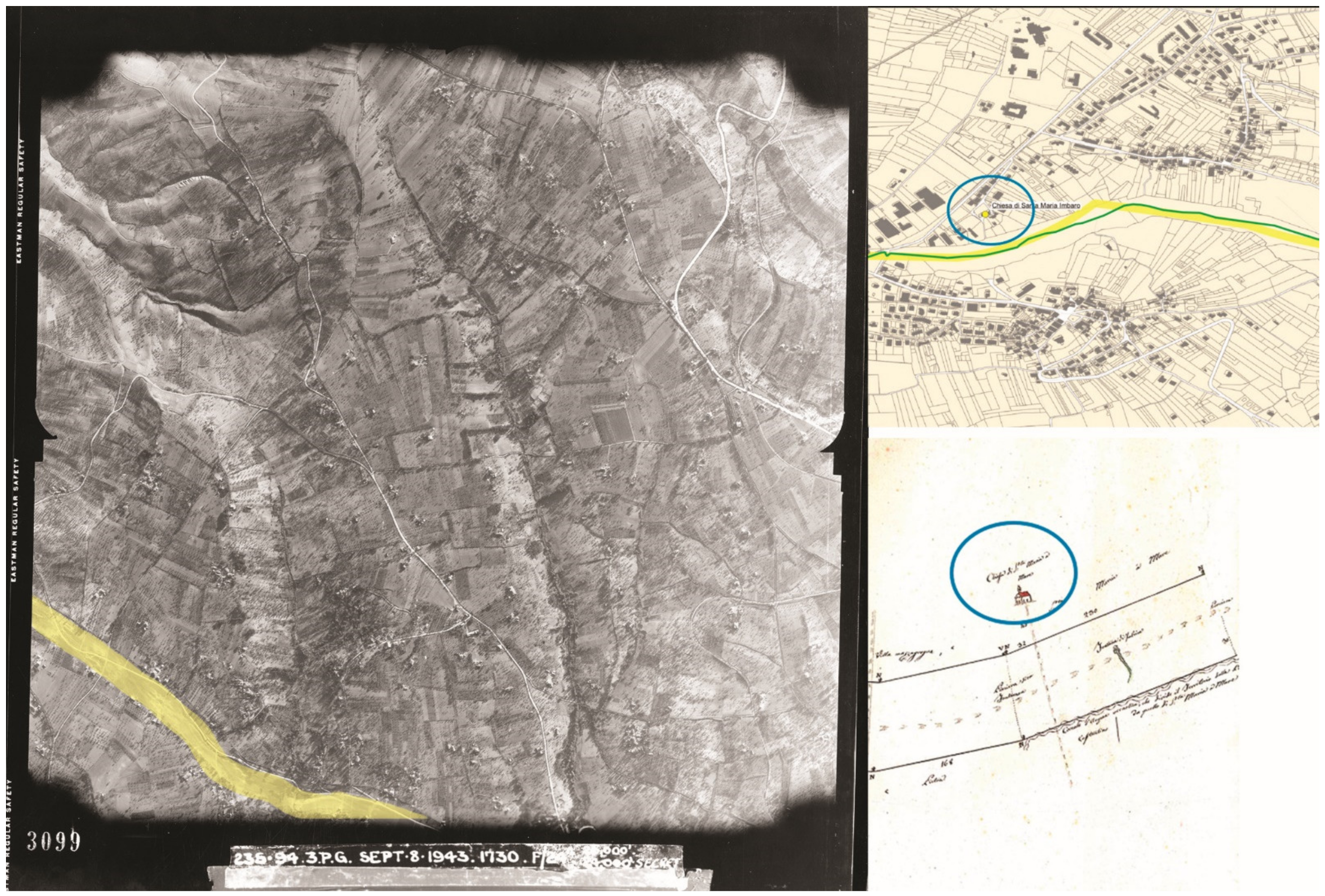
Afterward, the State Archives of Rome was consulted because, in the area, there was a front of the Second World War. Therefore, numerous flyovers were carried out for war purposes by the British Royal Air Force, even on significant dates (
Figure 4). With these aerial photos, the layout of the Tratturo Magno is evident because it predates a law of the Abruzzo Region that allowed portions of the Tratturo to be cultivated temporarily. This survey method was accompanied by a census of the route using the database of the Revenue Agency by analysing the cadastral subdivision of land in the area. The original route maintains a certain continuity from a cartographic point of view instead of the areas adjacent to the Tratturo, which are divided into numerous parcels of various areas without any link of continuity. This tracing method was finally validated through access to a GPS track made available by a group of scholars passionate about the Tratturo Magno and who annually travel the entire route [
26]. The procedure described allows the tracing of the route with an accuracy in the order of one meter. This definition is due to the multiscalarity of the data from cartographic and historical sources, which allows its use for urban and territorial connections. The application for the conversion of this route into slow mobility connections can therefore take place through the definition of exact areas of influence. Following a study of the area already described in the introduction, three additional major slow mobility routes were identified: the “Cammino di San Tommaso”, the Gustav Line, and the Sentiero della Libertà. For the exact geolocalization of these paths, when not digitally provided in GPX formats by the respective associations, a simple web-scraping procedure was applied, extracting the point data from the web sources and reconverting the syntax to make the data manageable for a GIS platform. The last surveyed feature is “Trabucchi”, ancient fishing machines located along the coast, which uniquely characterize this area from the rest of the Adriatic coast. Due to their nature, these elements are structurally unstable [
10], and their presence in the territory is continually put at risk by atmospheric agents that can wreck them. Because of the continuous evolution of the building consistency, it has become necessary to survey all the structures present, which at the moment of writing this article, has registered 29 trabucchi in the coastal stretch in question.
4. Outcomes
The result of this research is the creation of a useful strategy to identify the most suitable routes in terms of spatial quality and walkability/cyclability. The method has been tested on a specific territory, and it aspires to recover the previous cross-routes between the interior and the coast, which have been erased by predominantly longitudinal development. Thus, a hierarchy is structured that privileges coastal centers, while those along the transversal routes are subject to processes of isolation and consequent depopulation. When the opportunity arises to use a greenway that travels longitudinally to the coast, then one can consider reconnecting the nodes and relationships inland, thereby achieving the goal of more balanced land use. This method allows the identification of nodes that intercept routes, seeking to develop strategies for optimizing slow mobility flows. These strategies can be used in all contexts where there is the main route and many cross-connections that can be composed into a single network through the minor routes that allow a more organic use of the territory.
The creation of the network consisting of paths and nodes was characterised by several problems. It was much more complex to identify the routes than the nodes because the former needed lengthy bibliographic research first and a field survey later. The latter, on the contrary, were available by consulting open-source spatial databases. It was possible to identify a series of paths that cross the territory intercepting all the other networks and pointing out meaningful nodes. Most of these nodes are already present in the territory by intercepting the railway, the motorway and the slow routes, respectively. A small part, on the contrary, does not exist, and it would be desirable for them to be generated and developed. These have been divided into two distinct families; the first and most widespread on the territory is that of the intermodal nodes, in which the fast and long networks intercept the slow networks. These are located in areas of the territory that are potentially the most suitable for developing mobility networks by their position. The second type of node is located at the intersections of the slow mobility routes, identified in green as route nodes. These nodes do not exist and should be created.
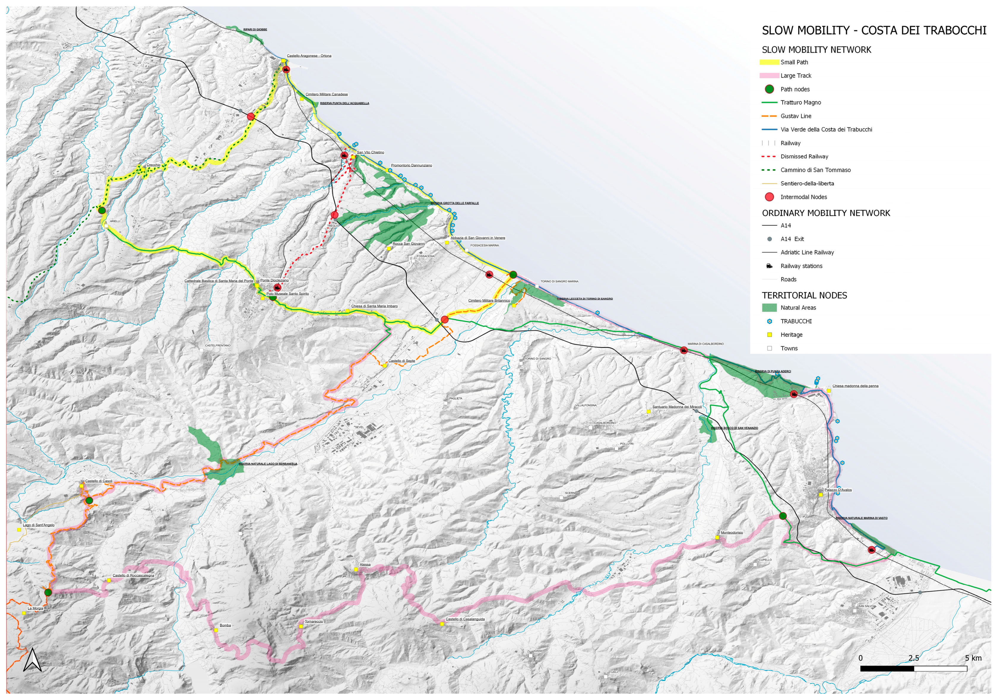
From each node, the connections to the proximity elements have been identified. The systematization of all the elements in a unique network led to the hypothesis of two paths, as shown in
Figure 5. The first, called Small Ring, is 55 km in length and unites the coastal system through the transversal routes with the Tratturo Magno that crosses this area from west to east with the city of Lanciano in the center of the route. Through this ring, it is possible to travel the greenway of the Costa dei Trabucchi, passing through Ortona on the Way of St. Thomas to Arielli. From Arielli, you can follow the Tratturo Magno until you intercept the Linea Gustav on the Val di Sangro. Following this final itinerary along the course of the river Sangro, it is possible to reconnect with the coast, where it is possible to find the greenway again, as shown in
Figure 6. A second, much longer itinerary, 187 km long, called Large Ring partly embraces the previous itinerary, starting from Ortona up to the intersection with the Gustav Line, running along the course of the Sangro river in the opposite direction to the previous itinerary, which is towards the inland up to intercept the Sentiero della Libertà. From that point, an itinerary that touches several municipalities rich in valuable elements is marked with a unique legend. In this way, we intercept a stretch of the Tratturo Magno south of the town of Vasto, which we follow until we reach the greenway.
5. Discussion
The advantage of this method is its efficiency stemming from three main features:
- (1)
Overcoming limitations due to data scarcity;
- (2)
Use of open-source data;
- (3)
Multiscalarity of analyses.
All areas of remote accessibility, as in the case study, create issues from the point of view of mobility and the scarcity of data. In fact, the method proposed conducts a detailed analysis of the territory from both the morphological and network perspectives starting from the data available from open geo-databases.
The use of open-source data is an advantage both in terms of the scientific reproducibility of the research and the possibility of cross-application of the same digital procedure in different contexts. It is applicable to three-dimensional modeling of the territory and for path quality assessment to any territory. The photographic surveys underlying the assessment can also be gained from the web and thus form the basis for the assessment regardless of the territory chosen. The use of the methodologies described allowed for more precise results in less time than the traditional interview system characteristics of the studies mentioned in the literature review.
The multiscalarity of analyses contributes to managing systems with a single digital ecosystem to design node crossings, intermodal connections of nodes, and their connecting paths.
The decommissioning of a railway line in and of itself produces a boost in the development of slow mobility routes that remain confined to the immediate vicinity of the line. Tracing routes connecting inland territories with the greenway has a benefit if and only if it connects places of scenic/monumental/anthropic value. Those traced precisely avoid the route as an end in itself, which has been proven not to work [
27].
The methodologies covered in this paper produce major benefits in the development of tourism. The techniques developed to enable an optimisation of the transfer of tourist flows from the coast to the interior. This process, accomplished through slow mobility, allows for the sustainable development of tourism. Non-tourist flows are also improved both during the crowdy summer period and during the off-season.
The main limitation of the explained methodology is the choice of a single marginal context as opposed to one in which tourism value is widely recognised. The choice of a context other than the one described would have been complex since the specific purpose of the study was to test the method in a context with scarce data. Once the efficiency of the methodology has been tested in such a complex context, it becomes easier to apply it to a more data-rich territory.
In contexts such as a case study, it is difficult to collect new data with traditional methods, to improve the reliability of the results obtainable with the existing methods.
The actual methodology, unlike the others described in the literature review, is based on objective data instead of interviews. The quantitative measurement of the value of a route is thus based on parameters that can be uniformly checked and validated. Interviews, on the contrary, always contain a subjectivity factor that is limited by increasing the number of interviews. However, as the number increases, the competence of the interviewees themselves is often reduced, as is their knowledge of the area, especially in specific case studies such as the one presented.
6. Future Developments
The future development of this work is the application of the methodology to a different context to validate its efficiency. A context with similar morphological and infrastructural characteristics is the Matera area, where railway stations located on the main axes that are aligned along the river valleys can be connected with slow mobility solutions to the historical centres, normally up on the hills and separated by a relevant distance.
There are ongoing research advances for all of the methodologies identified in this work, refining the individual approaches by integrating them into a single spatial development ecosystem. For the NURBS + DTM system, experimentation with genetic algorithms for applying constraints such as zoning and land use of particular areas is underway. For the combination of GIS and quality indexes, experimentation is underway to analyse the paths punctually and assigning a quality score that can be measured locally. Soon, it will be possible to integrate Remote Sensing contributions from satellite data and drones to acquire further data to evaluate the quality of the crossed landscapes.
7. Conclusions
The research requests to reconnect hillside villages with the coast through soft mobility networks were supported by the structuring of the digital and analogue methods. The outcome of this study generated a network consisting of two routes connecting the most relevant nodes of the area, the opportunity to consolidate the role of the existing nodes (villages), to upgrade the already existing ones (service areas and dismissed railway stations) and eventually propose the attribution of the role of a node to other existing places located close to the infrastructure (intersections between tratturi and roads). The relevance of this work lies in the development of useful strategies for detailed analyses and the application of solutions in territories with similar problems. The efficiency of this strategy, combined with the multiscalarity applied to open data worldwide, make it applicable in numerous contexts where standard analyses cannot be used. The immediacy of these strategies, combined with their flexibility of use even in data-poor areas, makes them useful for identifying new areas to develop sustainable mobility practices.


