


Multimodal Access to Minor Places in Heritage-Rich Landscapes: GIS Mapping to Define Slow-Tourism Routes from the Stations in the Railway Networks in-between Turin and Milan


Abstract
1. Introduction
2. Theoretical Background
2.1. Multimodality and Cycling Tourism
2.2. Slow-Tourism Routes Conception
2.3. GIS-Based Methods for Slow Tourism
3. Materials and Method
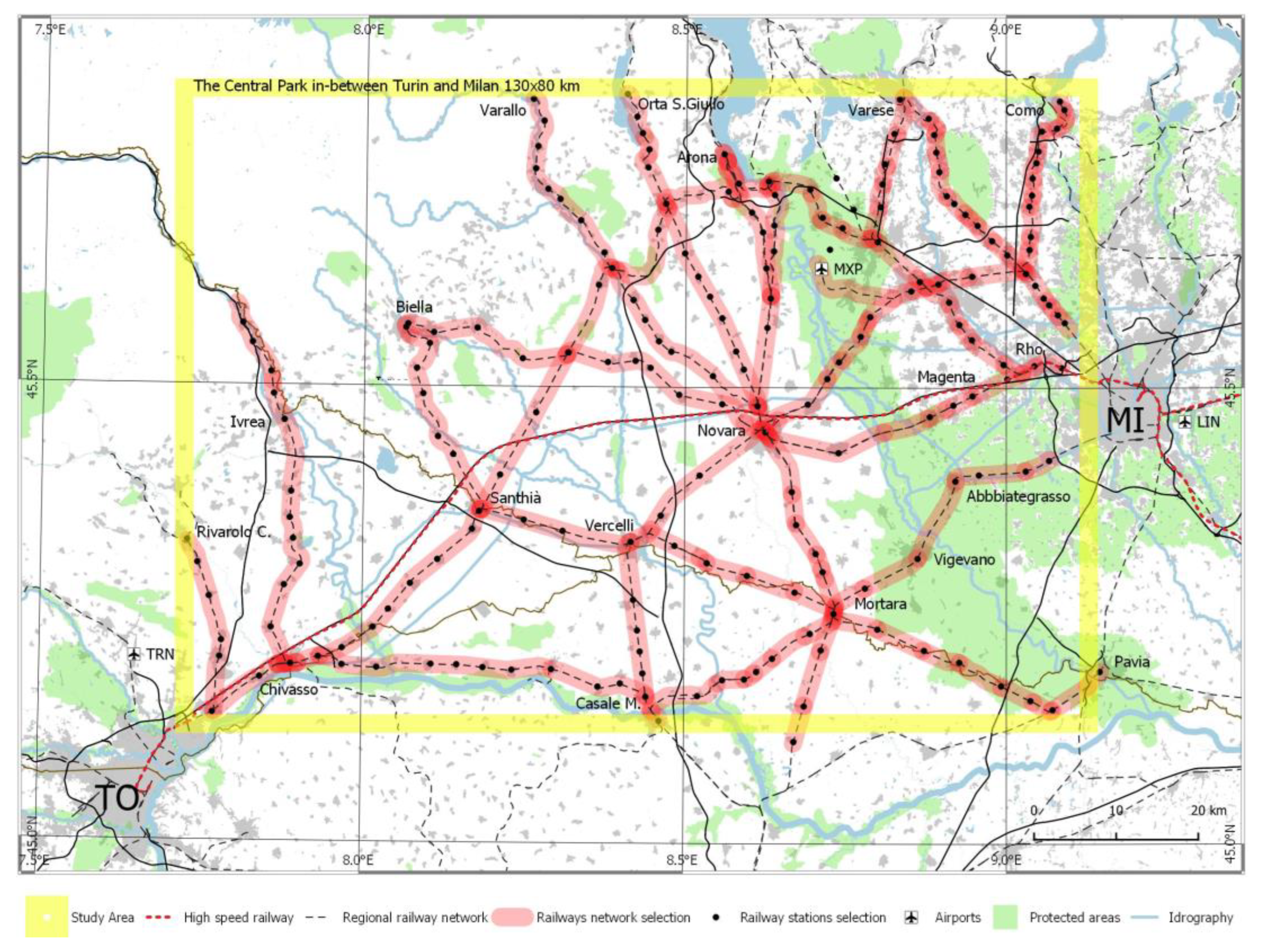
3.1. Study Area: The “Central Park” In-between Turin and Milan
3.2. Materials
3.3. Method
3.3.1. Data Collection
3.3.2. Data Processing
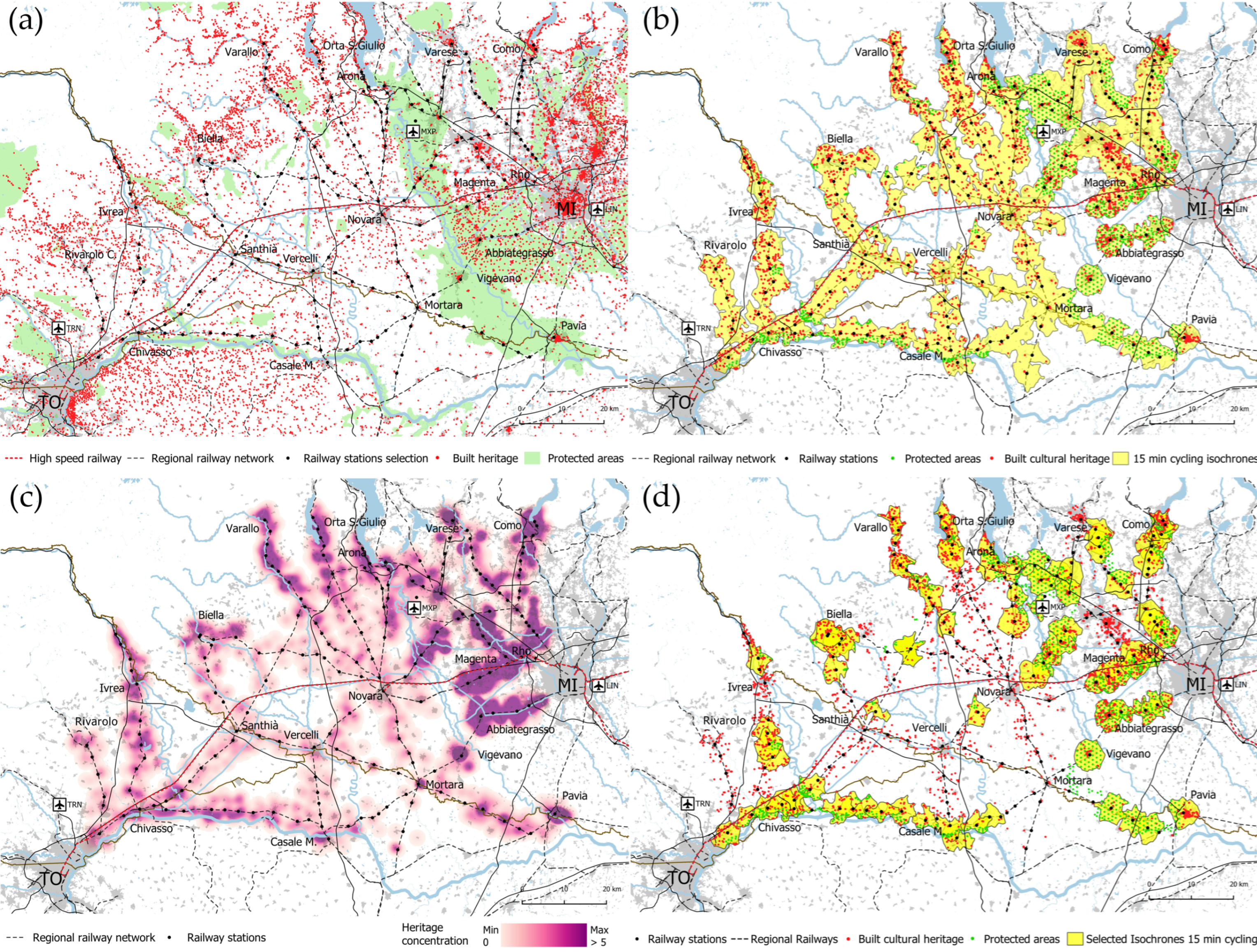
3.3.3. Playground Definition
3.3.4. Heritage Selection
3.3.5. Most Attractive Heritage Areas Selection
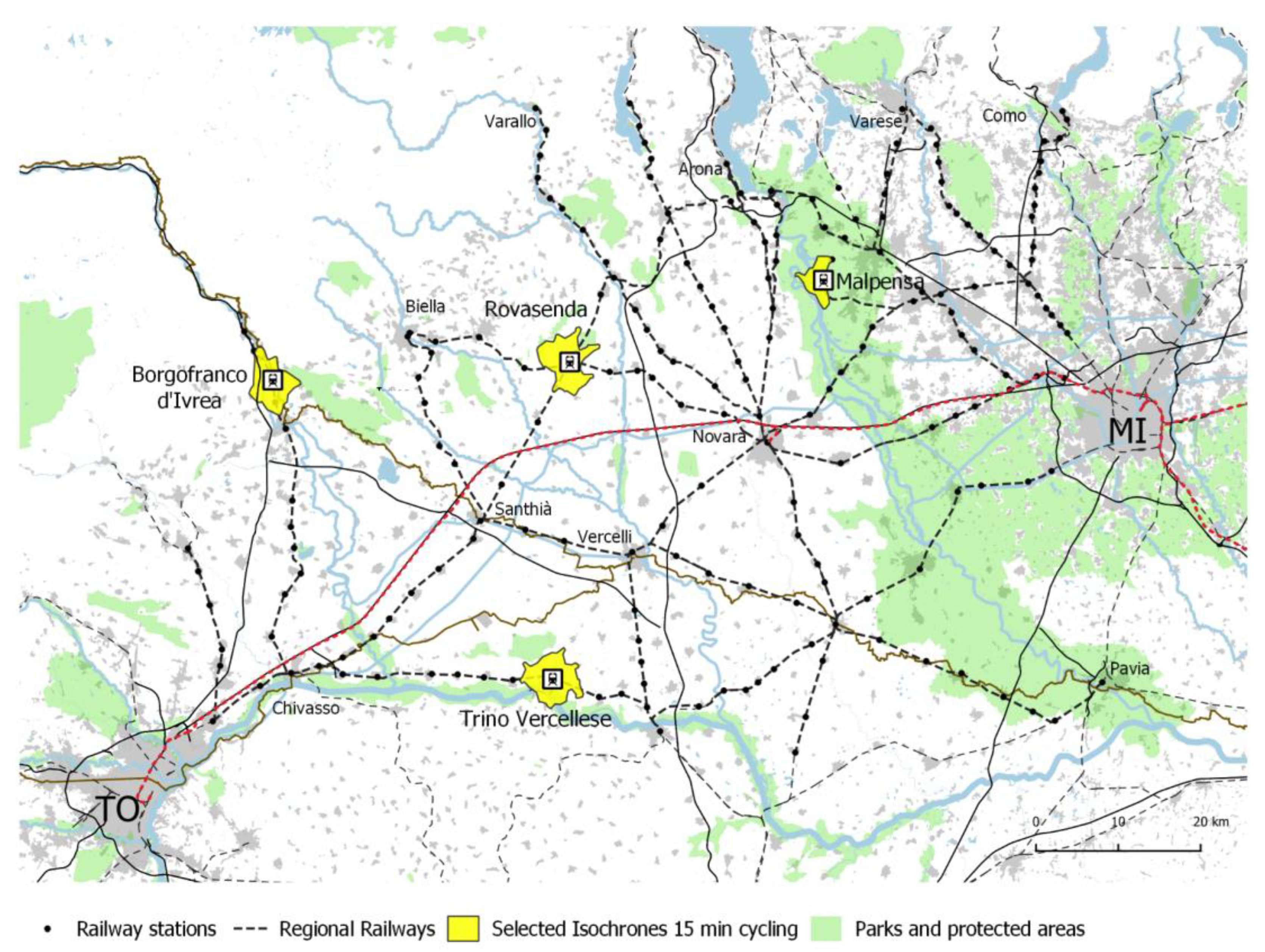
3.3.6. Routing
4. Results
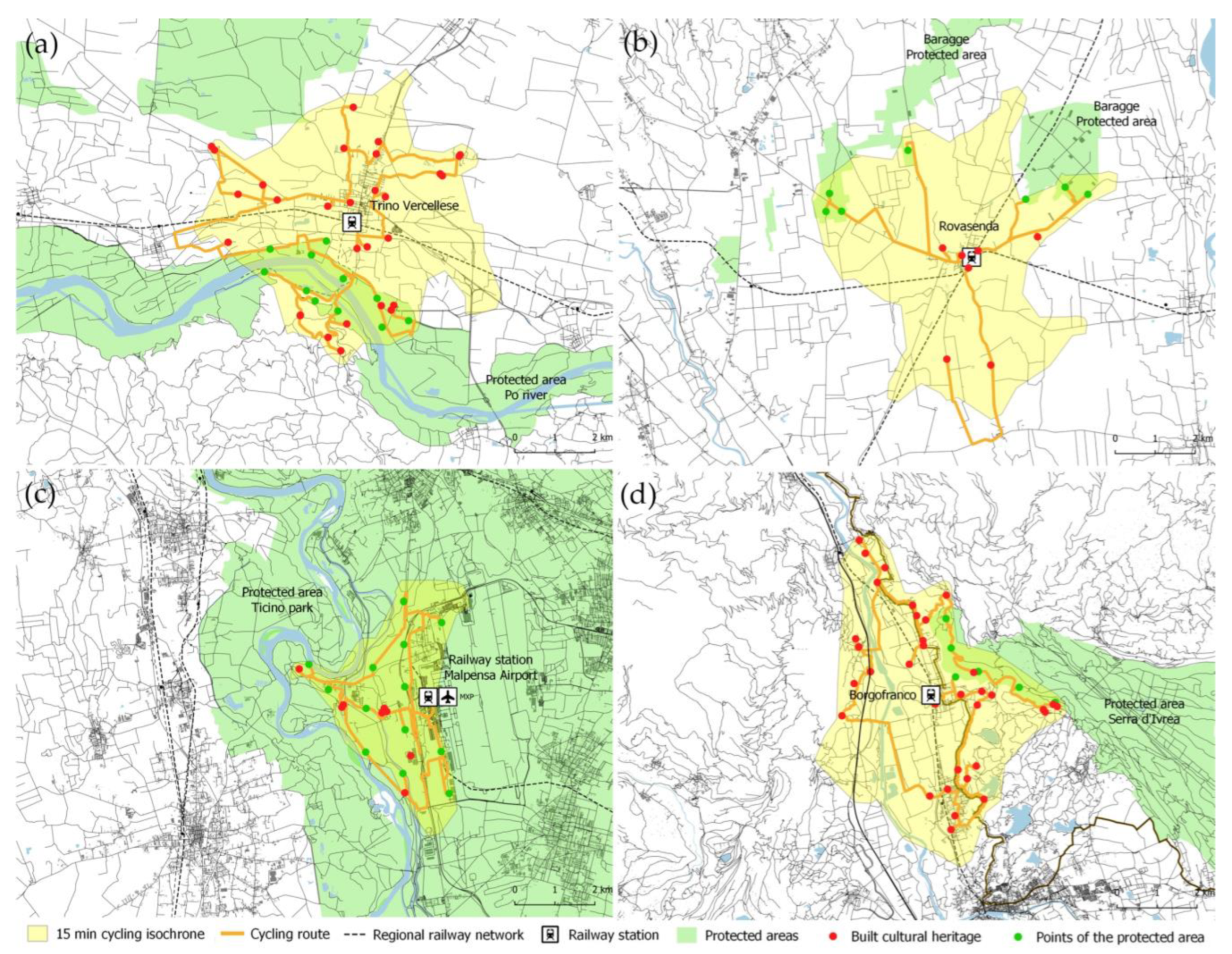
4.1. Trino Vercellese
4.2. Rovasenda
4.3. Milan Malpensa
4.4. Borgofranco d’Ivrea
5. Discussion
6. Conclusions
Author Contributions
Funding
Informed Consent Statement
Conflicts of Interest
References
- Dickinson, J.; Lumsdon, L. Slow Travel and Tourism; Routledge: London, UK, 2011; ISBN 978-1-84977-649-3. [Google Scholar]
- Givoni, M.; Brand, C.; Watkiss, P. Are Railways Climate Friendly? Built Environ. 2009, 35, 70–86. [Google Scholar] [CrossRef]
- Zamparini, L.; Maltese, I. Introduction. In Sustainable Transport and Tourism Destinations; Transport and Sustainability; Emerald Publishing Limited: Bingley, UK, 2021; Volume 13, pp. i–xviii. ISBN 978-1-83909-128-5. [Google Scholar]
- Gössling, S. Global Environmental Consequences of Tourism. Glob. Environ. Chang. 2002, 12, 283–302. [Google Scholar] [CrossRef]
- Dickinson, J.E.; Lumsdon, L.M.; Robbins, D. Slow Travel: Issues for Tourism and Climate Change. J. Sustain. Tour. 2011, 19, 281–300. [Google Scholar] [CrossRef]
- Ritchie, B.W.; Hall, C.M. Bicycle Tourism and Regional Development: A New Zealand Case Study. Anatolia 1999, 10, 89–112. [Google Scholar] [CrossRef]
- European Commission. Communication from the Commission to the European Parliament, the Council, the European Economic and Social Committee and the Committee of the Regions. A European Strategy for Low-Emission Mobility; European Commission: Brussels, Belgium, 2016. [Google Scholar]
- Buehler, R.; Pucher, J. Cycling through the COVID-19 Pandemic to a More Sustainable Transport Future: Evidence from Case Studies of 14 Large Bicycle-Friendly Cities in Europe and North America. Sustainability 2022, 14, 7293. [Google Scholar] [CrossRef]
- Isnart; Legambiente Viaggiare con la bici. Caratteristiche ed economia del cicloturismo in Italia 2° Rapporto Isnart-Legambiente Bike Summit 2020. 2020. Available online: https://www.legambiente.it/wp-content/uploads/2020/11/BikeSummit_2020.pdf (accessed on 10 November 2022).
- Maggi, E.; Ossola, P.; Grechi, D.; Crotti, D. Cycle Tourism as a Driver for a Sustainable Local Development. The Case of a Natural Tourist Destination in a North-Western Area of Italy. In Sustainable Transport and Tourism Destinations; Zamparini, L., Ed.; Transport and Sustainability; Emerald Publishing Limited: Bingley, UK, 2021; Volume 13, pp. 159–178. ISBN 978-1-83909-128-5. [Google Scholar]
- Pileri, P.; Moscarelli, R. From Slow Tourism to Slow Travel: An Idea for Marginal Regions. In Cycling & Walking for Regional Development: How Slowness Regenerates Marginal Areas; Pileri, P., Moscarelli, R., Eds.; Research for Development; Springer International Publishing: Cham, Switzerland, 2021; pp. 3–16. ISBN 978-3-030-44003-9. [Google Scholar]
- Gazzola, P.; Pavione, E.; Grechi, D.; Ossola, P. Cycle Tourism as a Driver for the Sustainable Development of Little-Known or Remote Territories: The Experience of the Apennine Regions of Northern Italy. Sustainability 2018, 10, 1863. [Google Scholar] [CrossRef]
- Andreoli, A.; Silvestri, F. Tourism as a Driver of Development in the Inner Areas. Ital. J. Plan. Pract. 2017, 7, 80–99. [Google Scholar]
- Ciascai, O.R.; Dezsi, Ș.; Rus, K.A. Cycling Tourism: A Literature Review to Assess Implications, Multiple Impacts, Vulnerabilities, and Future Perspectives. Sustainability 2022, 14, 8983. [Google Scholar] [CrossRef]
- Pantelaki, E.; Crotti, D.; Maggi, E. Cycling Tourism in Italy: Multimodal Transport Behaviours in a Latent Class Analysis. Res. Transp. Bus. Manag. 2022, 100861. [Google Scholar] [CrossRef]
- Petino, G.; Reina, G.; Privitera, D. Cycling Tourism and Revitalization in the Sicilian Hinterland: A Case Study in the Taormina–Etna District. Sustainability 2021, 13, 10022. [Google Scholar] [CrossRef]
- Martens, K. Promoting Bike-and-Ride: The Dutch Experience. Transp. Res. Part Policy Pract. 2007, 41, 326–338. [Google Scholar] [CrossRef]
- Olafsson, A.S.; Nielsen, T.S.; Carstensen, T.A. Cycling in Multimodal Transport Behaviours: Exploring Modality Styles in the Danish Population. J. Transp. Geogr. 2016, 52, 123–130. [Google Scholar] [CrossRef]
- Moscarelli, R.; Pileri, P.; Giacomel, A. Regenerating Small and Medium Sized Stations in Italian Inland Areas by the Opportunity of the Cycle Tourism, as Territorial Infrastructure. City Territ. Archit. 2017, 4, 13. [Google Scholar] [CrossRef]
- González Relaño, R.M.; Ventura Fernández, J.; Contreras Cabrera, G.A. Cycle Tourism in Rural Areas: Promoting a Rail Trail Network in Andalusia, Spain. Ciclotur. Espac. Rural. Promoviendo Una Red Vías Verdes Andal. 2021, 48, 209–241. [Google Scholar] [CrossRef]
- Givoni, M.; Rietveld, P. Do Cities Deserve More Railway Stations? The Choice of a Departure Railway Station in a Multiple-Station Region. J. Transp. Geogr. 2014, 36, 89–97. [Google Scholar] [CrossRef]
- Ciclovie. 20 percorsi ciclabili da raggiungere comodamente in treno. Available online: https://issuu.com/ferroviedellostatoitaliane/docs/travel_book_20_ciclovie_def1 (accessed on 10 November 2022).
- European Parliament The European Cycle Route Network EuroVelo 2012. Available online: https://ecf.com/files/wp-content/uploads/The-european-cycle-route-network-EuroVelo.pdf (accessed on 10 November 2022).
- Rolando, A.; D’Armento, S.; Scandiffio, A. Tracing a Cycle Route between the UNESCO Sites and the National Parks of Apulia and Basilicata: A Design Oriented Strategy for Sustainable Tourism. In TURISMO Y PASAJE 2; Tirant Humanidades: Valencia, Spain, 2020; pp. 261–281. ISBN 978-84-18534-14-0. [Google Scholar]
- Novack, T.; Wang, Z.; Zipf, A. A System for Generating Customized Pleasant Pedestrian Routes Based on OpenStreetMap Data. Sensors 2018, 18, 3794. [Google Scholar] [CrossRef]
- Quercia, D.; Schifanella, R.; Aiello, L.M. The Shortest Path to Happiness: Recommending Beautiful, Quiet, and Happy Routes in the City. In Proceedings of the 25th ACM Conference on Hypertext and Social Media, Association for Computing Machinery. New York, NY, USA, 1 September 2014; pp. 116–125. [Google Scholar]
- Milano BikeDistrict. Available online: http://www.bikedistrict.org/#/45.46372,9.19106/45.46844,9.18018/t (accessed on 11 November 2022).
- Bunet. Available online: https://www.bunet.torino.it/ (accessed on 11 November 2022).
- Naviki—Pianificazione Dei Percorsi Ciclabili in Tutto Il Mondo. Available online: https://www.naviki.org/it/naviki/pianifica-itinerari/#p=45.46364793403194,9.202406019375445&z=13 (accessed on 11 November 2022).
- Lumsdon, L. Transport and Tourism: Cycle Tourism—A Model for Sustainable Development? J. Sustain. Tour. 2000, 8, 361–377. [Google Scholar] [CrossRef]
- Senes, G.; Rovelli, R.; Bertoni, D.; Arata, L.; Fumagalli, N.; Toccolini, A. Factors Influencing Greenways Use: Definition of a Method for Estimation in the Italian Context. J. Transp. Geogr. 2017, 65, 175–187. [Google Scholar] [CrossRef]
- Bender, O.; Schumacher, K.P.; Stein, D. Landscape, Seasonality, and Tourism: A Survey with Examples from Central Europe. In Seasonal Landscapes; Palang, H., Sooväli, H., Printsmann, A., Eds.; Landscape Series; Springer: Dordrecht, The Netherlands, 2007; pp. 181–213. ISBN 978-1-4020-4990-3. [Google Scholar]
- Lankhorst, J.R.-K.; De Vries, S.; Buijs, A. Mapping Landscape Attractiveness. A GIS-Based Landscape Appreciation Model for the Dutch Countryside. In Exploring the Visual Landscape: Advances in Physiognomic Landscape Research in the Netherlands; Research in Urbanism Series; IOS Press: Amsterdam, The Netherlands, 2011; Volume 2, ISBN 978-1-60750-832-8. [Google Scholar]
- Vannoppen, A.; Degerickx, J.; Gobin, A. Evaluating Landscape Attractiveness with Geospatial Data, A Case Study in Flanders, Belgium. Land 2021, 10, 703. [Google Scholar] [CrossRef]
- Peano, A. Fare Paesaggio: Dalla Pianificazione di Area Vasta All’operatività Locale; Alinea Editrice: Firenze, Italy, 2011; ISBN 978-88-6055-612-7. [Google Scholar]
- Longley, P.; Goodchild, M.; Maguire, D.; Rhind, D. Geographical Information Systems: Principles, Techniques, Management and Applications. Volume 1: Principles and Technical Issues, 2nd ed.; Wiley: New York, NY, USA, 1999. [Google Scholar]
- Malczewski, J. GIS-Based Land-Use Suitability Analysis: A Critical Overview. Prog. Plan. 2004, 62, 3–65. [Google Scholar] [CrossRef]
- Diti, I.; Torreggiani, D.; Tassinari, P. Rural Landscape and Cultural Routes: A Multicriteria Spatial Classification Method Tested on an Italian Case Study. J. Agric. Eng. 2015, 46, 23–29. [Google Scholar] [CrossRef][Green Version]
- Dezio, C.; Dell’Ovo, M.; Oppio, A. The Antifragile Potential of Line Tourism: Towards a Multimethodological Evaluation Model for Italian Inner Areas Cultural Heritage. In New Metropolitan Perspectives; Bevilacqua, C., Calabrò, F., Della Spina, L., Eds.; Smart Innovation, Systems and Technologies; Springer International Publishing: Cham, Switzerland, 2021; Volume 178, pp. 1819–1829. ISBN 978-3-030-48278-7. [Google Scholar]
- Meini, M.; Di Felice, G.; Nocera, R. Mappare le risorse delle aree interne: Potenzialità e criticità per la fruizione turistica. Boll. Dell'associazione Ital. Di Cartogr. 2017, 161, 4–21. [Google Scholar] [CrossRef]
- Scandiffio, A. Parametric Definition of Slow Tourism Itineraries for Experiencing Seasonal Landscapes. Application of Sentinel-2 Imagery to the Rural Paddy-Rice Landscape in Northern Italy. Sustainability 2021, 13, 13155. [Google Scholar] [CrossRef]
- Scandiffio, A. Mapping Spatial Quality of Slow Routes with a GIS-based method. A Comparative Assessment of alternative Routes. In The International Archives of the Photogrammetry, Remote Sensing and Spatial Information Sciences; Copernicus GmbH: Gottingen, Germany, 2019; Volume XLII-2-W15, pp. 1071–1076. [Google Scholar]
- Rovelli, R.; Senes, G.; Fumagalli, N.; Sacco, J.; De Montis, A. From Railways to Greenways: A Complex Index for Supporting Policymaking and Planning. A Case Study in Piedmont (Italy). Land Use Policy 2020, 99, 104835. [Google Scholar] [CrossRef]
- Goodchild, M.F. Citizens as Sensors: The World of Volunteered Geography. GeoJournal 2007, 69, 211–221. [Google Scholar] [CrossRef]
- Brovelli, M.A.; Kilsedar, C.E.; Minghini, M.; Zamboni, G. Web Mapping Technologies for the Valorization of Slow Tourism: The Via Regina Project. In Proceedings of the 18th AGILE International Conference on Geographic Information Science, Lisbon, Portugal, 9–12 June 2015; p. 6. [Google Scholar]
- Rolando, A.; Scandiffio, A. The Central Park in between Torino and Milano. In Proceedings of the Tasting the Landscape, Turin, Italy, 20–22 April 2016; Edifir-Edizioni: Torino, Italy, 2016; p. 336. [Google Scholar]
- Morandi, C.; Rolando, A.; Di Vita, S. From Smart City to Smart Region. Digital Services for an Internet of Places; Springer: Cham, Switzerland, 2016; ISBN 978-3-319-17338-2. [Google Scholar]
- Ballatore, L. Storia Delle Ferrovie in Piemonte, 1st ed.; Il Punto: Torino, Italy, 2002; ISBN 88-8855-200-6. [Google Scholar]
- Politecnico di Torino. Strade Ferrate in Piemonte. Cultura Ferroviaria Fra Otto e Novecento; Celid: Torino, Italy, 1993. [Google Scholar]
- Ministero Delle Politiche Agricole Alimentari e Forestali Elenco Degli Alberi Monumentali D’italia. Available online: https://www.politicheagricole.it/flex/cm/pages/ServeBLOB.php/L/IT/IDPagina/11260 (accessed on 26 September 2022).
- Openrouteservice. Available online: https://openrouteservice.org/ (accessed on 22 October 2021).
- Arsanjani, J.J.; Zipf, A.; Mooney, P.; Helbich, M. OpenStreetMap in GIScience. Experiences, Research, and Applications; Springer: Berlin/Heidelberg, Germany, 2015; ISBN 978-3-319-14280-7. [Google Scholar]
- Geoportale Lombardia. Available online: https://www.geoportale.regione.lombardia.it/download-dati (accessed on 26 September 2022).
- Geoportale Piemonte. Available online: https://www.geoportale.piemonte.it/cms/ (accessed on 26 September 2022).
- Corner, J. The Agency of Mapping: Speculation, Critique and Invention. In Mappings; Cosgrove, D., Ed.; Reaktion: London, UK, 1999; pp. 213–252. [Google Scholar]
- Abrams, J.; Hall, P. Else/Where Mapping. Mapping New Cartographies of Networks and Territories; University of Minnesota: Minneapolis, MN, USA, 2006. [Google Scholar]
- Bakogiannis, E.; Vlastos, T.; Athanasopoulos, K.; Vassi, A.; Christodoulopoulou, G.; Karolemeas, C.; Tsigdinos, S.; Kyriakidis, C.; Noutsou, M.-S.; Siti, M.; et al. Exploring Motivators and Deterrents of Cycling Tourism Using Qualitative Social Research Methods and Participative Analytical Hierarchy Process (AHP). Sustainability 2020, 12, 2418. [Google Scholar] [CrossRef]
- United Nations Transforming Our World: The 2030 Agenda for Sustainable Development 2015. Available online: https://sustainabledevelopment.un.org/content/documents/21252030%20Agenda%20for%20Sustainable%20Development%20web.pdf (accessed on 10 November 2022).
- Città e Cattedrali. Available online: https://www.cittaecattedrali.it/en/chiese_aperte?action=index&controller=chiese_aperte&locale=en (accessed on 14 November 2022).
- Idea Store—Home. Available online: https://www.ideastore.co.uk/ (accessed on 14 November 2022).


| Railway Stations | A | B | C | D | E | F | G |
|---|---|---|---|---|---|---|---|
| Inhabitants by Isochrone | Cycling Route Length | Total Heritage | Built Heritage | Protected Areas | Points Discretization of Protected Areas | Heritage Typologies | |
| [n.] | [km] | [n.] | [n.] | [n.] | [n.] | [n.] | |
| Trino Vercellese | 7401 | 51 | 40 | 29 | 1 | 11 | 13 |
| Rovasenda | 957 | 34 | 14 | 7 | 2 | 7 | 8 |
| Malpensa | 976 | 30 | 21 | 8 | 1 | 13 | 9 |
| Borgofranco d’Ivrea | 8971 | 39 | 39 | 33 | 1 | 6 | 14 |
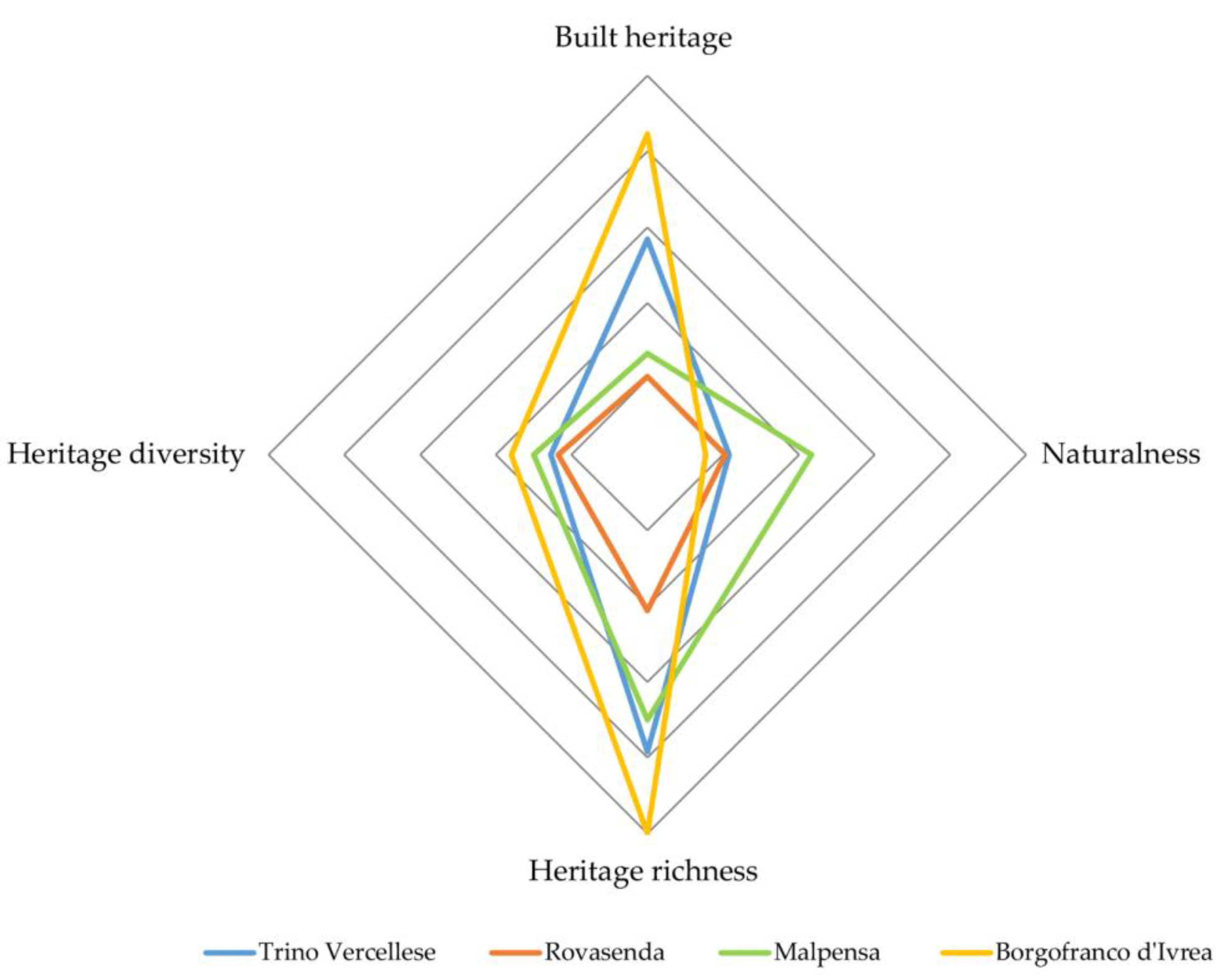
| Railway Stations | Built Heritage | Naturalness | Heritage Richness | Heritage Diversity |
|---|---|---|---|---|
| [D/B] | [F/B] | [C/B] | [G/B] | |
| [n./km] | [n./km] | [n./km] | [n./km] | |
| Trino Vercellese | 0.57 | 0.22 | 0.78 | 0.25 |
| Rovasenda | 0.21 | 0.21 | 0.41 | 0.24 |
| Malpensa | 0.27 | 0.43 | 0.70 | 0.30 |
| Borgofranco d’Ivrea | 0.85 | 0.15 | 1.00 | 0.36 |
Publisher’s Note: MDPI stays neutral with regard to jurisdictional claims in published maps and institutional affiliations. |
© 2022 by the authors. Licensee MDPI, Basel, Switzerland. This article is an open access article distributed under the terms and conditions of the Creative Commons Attribution (CC BY) license (https://creativecommons.org/licenses/by/4.0/).
Share and Cite
Rolando, A.; Scandiffio, A. Multimodal Access to Minor Places in Heritage-Rich Landscapes: GIS Mapping to Define Slow-Tourism Routes from the Stations in the Railway Networks in-between Turin and Milan. Sustainability 2022, 14, 15723. https://doi.org/10.3390/su142315723
Rolando A, Scandiffio A. Multimodal Access to Minor Places in Heritage-Rich Landscapes: GIS Mapping to Define Slow-Tourism Routes from the Stations in the Railway Networks in-between Turin and Milan. Sustainability. 2022; 14(23):15723. https://doi.org/10.3390/su142315723
Chicago/Turabian StyleRolando, Andrea, and Alessandro Scandiffio. 2022. "Multimodal Access to Minor Places in Heritage-Rich Landscapes: GIS Mapping to Define Slow-Tourism Routes from the Stations in the Railway Networks in-between Turin and Milan" Sustainability 14, no. 23: 15723. https://doi.org/10.3390/su142315723
APA StyleRolando, A., & Scandiffio, A. (2022). Multimodal Access to Minor Places in Heritage-Rich Landscapes: GIS Mapping to Define Slow-Tourism Routes from the Stations in the Railway Networks in-between Turin and Milan. Sustainability, 14(23), 15723. https://doi.org/10.3390/su142315723