Article

Urban Transition and the Return of Neighbourhood Planning. Questioning the Proximity Syndrome and the 15-Minute City

by
Elena Marchigiani
1,* and
Bertrando Bonfantini
2
1
Department of Engineering and Architecture, University of Trieste, Via Alfonso Valerio 6/1, 34127 Trieste, Italy
2
Department of Architecture and Urban Studies, Politecnico di Milano, Via Bonardi 3, 20133 Milano, Italy
*
Author to whom correspondence should be addressed.
Sustainability 2022, 14(9), 5468; https://doi.org/10.3390/su14095468
Submission received: 1 April 2022 / Revised: 26 April 2022 / Accepted: 28 April 2022 / Published: 2 May 2022
(This article belongs to the Special Issue Towards a Sustainable Urban Planning for the Green Deal Era)

Abstract

:
European policies acknowledge cities’ major roles in building greener and just urban habitats. When rethinking cities’ spatial organisation, the call is for creating better liveability conditions at the level closest to citizens. In this frame, research into the impacts of COVID-19 has led to a revival of neighbourhood planning and the 15-Minute City has been proposed as a successful model for cities’ recoveries in the name of regained proximity to collective facilities. This article questions the long-lasting neighbourhood image that the 15-Minute City refers to, by exploring recent experiences that renewed its application. We begin with a literature review, and then develop an evidence-based approach to a deeper analysis of policy design and implementation focusing on the Italian city of Milano. Discussion and conclusions highlight critical issues and potentials of the 15-Minute City. If the threat is that of a simplified and rhetorical use of this idea, its ability to gather plural actions under an appealing flagship can be a powerful driver for urban regeneration policies. However, being more than just a reproducible spatial model, the 15-Minute City needs to be handled as a complex planning device, whose effective implementation depends on the specific characteristics of the urban environments it applies to and on the strong intertwining of different policy fields and tools.

1. Introduction

Cities are facing a triple crisis: “tackling the health impacts of COVID-19; dealing with the climate and ecological emergency; and addressing social and economic inequality. Despite these challenges, cities have the potential to become a major driving force for a green and just recovery in Europe—provided that they are actively involved in the decision-making process from the beginning” [1]. These key messages underpin the urban agenda the European Union has relaunched for the 2021–2027 programming period: from the European Green Deal strategy (EGD) [2]; to the post-pandemic funds delivered by the NextGenerationEU and the Recovery and Resilience Facility instruments [3]; up to the New European Bauhaus initiative (NEB), created to support the transformation of the built environment and urban spaces from a local and community co-designed perspective [4]. This wide-ranging policy framework aims to tackle climate change by cutting EU emissions to net-zero by 2050 and by fostering the transition towards sustainable, safe, and just social and economic growth.
Cities play a pivotal role in the ‘green and just recovery’ for outstanding reasons. In the EU-27 territories, urban settlements with more than 50,000 inhabitants are estimated to produce 36% of greenhouse gas emissions; in 2050, Europe’s level of urbanisation is expected to increase to approximately 83.7%, and cities will host nearly 85% of the European population. Cities are also hubs of innovation and social engagement; here 65% of climate mitigation actions and about 90% of climate adaptation measures are being implemented [5,6,7]. The EU flagship mission Climate-Neutral and Smart Cities is specifically conceived to apply the EGD at the local level, by helping 100 cities reach climate neutrality by 2030 and providing concrete examples for the EU to follow.
The requested quality of transformations goes far beyond environmental and technological solutions, encompassing a complex ecological approach where the eco-friendly performance of urban habitats, healthy living, energy and resource efficiency, sustainable mobility, balanced social and economic growth and the renewal of urban planning and governance intertwine [8,9,10]. The assumption is that long-term systemic change cannot only rely on macro-level innovation. To achieve fast results, improved technical capabilities and adequate financial resources are also needed on a local scale. The quest is for effective adaptation in everyday lifestyles and consumption patterns, and for a consistent reorganisation of the functionalities and uses of urban spaces. Following the maxim ‘Think Global Act Local’, and under the quest for location-based responses, radical change is understood as being strongly dependant on the evolution of city administrations’ routines away from the traditional silo-based approach and towards a cross-cutting and citizen-driven way of operating [11].

1.1. Green and Just Recovery Searching for Spatial Models

Today, when reaffirming the crucial role that has long been played by urban centres, some novelties emerge from policy strategies and research debates. In the face of a transition that is perceived as urgent, the language of general guidelines and goals that still characterises UN and EU agendas [12,13,14,15], and the showcase of good practices developed as a result of former EU projects, e.g., [16,17], are supported by proposals for ‘new urban models’. Namely, approaches to sustainable urban regeneration that can be replicated to provide a direct reference both for capacity-building actions addressed to public administrations and for a quick implementation of pilot projects [18,19,20,21].
These models share some common features: (i) they consist of spatialised interventions that, from single urban sectors and through local communities’ involvement, can be upscaled to rethink the whole city’s organisation; (ii) each time by emphasising the principles of a city that is car-free and walkable, compact, and as neutral as possible with regard to the use of resources, they all convey a potential to bring together many fields of action (climate adaptation, soft mobility, renewal of spaces and facilities, restoration of natural capital, circular and social economies, positive energy districts); (iii) they showed effectiveness when enacted in reaction to the sanitary crisis.
The most-recurring models include the realisation of well-distributed pedestrian-friendly zones such as the Superblocks (Superilles) in Barcelona, a programme started in 2016 from the temporary pedestrianisation of public spaces in between building blocks that is now spreading through the city to create a stable network of green hubs and squares [22,23]; the somewhat similar Healthy Street Approach and the Low Traffic Neighbourhoods plan, implemented in London as a pillar of the Mayor’s Transport Strategy (2018) with the aim of improving air quality, reducing congestion, and helping to make the city districts greener, healthier, and more attractive places [24,25]; the Doughnut model [26], taken as the guiding principle of Circular Economy Strategies such as the one launched in 2020 in Amsterdam to create new economies based on the reuse of raw materials and as a driver for the renewal of the existing built environment [27]; the 15-Minute City (with its many variations), adopted as a key element of the political programme that led to the re-election of Anne Hidalgo as the mayor of Paris in 2020.
Today, due to its allusion to comprehensive spatial regeneration, the 15-Minute City stands out as the model with the greatest media impact and as the one that is the most widely used as a reference for short- and long-term post-COVID urban action, not only at different institutional levels but also among large professional and financial networks e.g., [28,29,30,31].

1.2. The 15-Minute City Model: Issues and Questions

In 2016, Carlos Moreno—the Sorbonne professor who introduced “la ville du quarte d’heure”—described it as the way to “un nouveau chrono-urbanisme”, where time and space dimensions find a synthesis on the basis of a critique of car-centred planning and its effects on the separation of urban zones [32]. The city’s rearrangement into neighbourhoods according to four main criteria (“la proximité, la mixité, la densité, l’ubiquité”), based on the extensive use of information and communication technologies and active and sustainable mobility (walking, cycling, and public transport), is proposed as a solution for making collective facilities available in less than 15 min and as a prospect for rethinking urban contexts after the pandemic [33,34,35].
The 15-Minute City’s core principles are: “residents in every neighbourhood have easy access to goods and services, particularly groceries, fresh food, and health care; every neighbourhood has a variety of housing types, of different sizes and levels of affordability, to accommodate many types of households and enable more people to live closer to where they work; residents of every neighbourhood can breathe clean air, free from harmful air pollutants, and there are green spaces for everyone to enjoy; more people can work close to home or remotely, thanks to the presence of smaller-scale offices, shops and hospitality outlets, and co-working spaces” [36]. As Moreno highlights, at the heart of “la ville du quarte d’heure” is a mix of urban and social functions used to create a vibrant space within neighbourhoods according to concepts that can be replicated, such as fractals, across the entire city [37].
The 15-Minute City’s strength can be acknowledged in it being as clear in its aims as it is capable of bringing together a plurality of spatial dimensions relating to the well-being of people and the environment. It can be adopted as a manifesto: a metaphor that is easy to communicate, is immediate, and is holistic, but apparently not too revolutionary to deeply challenge the cities’ organisation, and achievable with efforts that are within the reach of local governments. Another motivation for its political appeal is that it theoretically ensures a way of addressing rising concerns over environmental pollution and climate change by an intuitive rubric of local actions that inhabitants can test against their own experiences.
The other side of the coin is, however, the risk of reducing city life complexities to the proximity of some functions (mobility, dwelling, work, education, healthcare, commerce, and entertainment), and the topics of environmental, social, and economic transition to a vague image of a ‘polycentric city’, where ‘complete’ and ‘self-sufficient’ neighbourhoods should provide solutions to all dwellers’ basic needs. In fact, the translation into practise of this idea strongly depends on local circumstances, social habits, existing spatial, administrative, and urban policies’ frameworks, and the threat of the segregation and isolation of some neighbourhoods and city sectors should not be eluded [38,39].
The aim of this article is to question these issues. To what extent does the idea of a 15-Minute City foster innovative interpretations of the long-lasting tradition of neighbourhood planning? If the city with a few minutes’ proximities lends itself to be taken as a ‘new’ spatial model with a character of reproducibility [40], it more or less directly refers to a number of planning theories that have been developed between the nineteenth and the twentieth centuries as a reaction to the anguish felt by the effects of the indefinite growth of a city and the fear of its disappearance [41]. An anguish and a fear that have persisted up to the present. The solutions produced over time by this rich array of ideas and practices provide clues to go beyond the fascination with the model and to highlight the limits of its today’s partial readings, as well as its possible evolutionary perspectives. Dismissing the 15-Minute City as dejà vu would in fact itself be reductive, if nothing else because it has been a long time since an ‘idea of the city’ with strong spatial characterisation had enjoyed such widespread success.
Starting from these hypotheses, and through an extensive review of research, institutional, and grey literature, the second section of this article builds a double excursus: on the one hand, the investigation of pandemic-related international policy debate and of recent planning experiences allow us to analyse the extent to which the revival of neighbourhood planning inherent in the 15-Minute City can address the construction of overall city visions; on the other hand, the recall of some of its historical roots emphasises issues that are still open to debate.
The third section provides methodological inputs to address these topics. Questioning the nexus between neighbourhood planning and proximity helps focus some research hypotheses on the exploration of the 15-Minute model’s impact on contemporary cities’ regeneration. The assumption is that a better evaluation of its concrete influence on urban governance needs a critical, contextual, and evidence-based analysis of urban policies as multi-level and multi-field combinations of political discourse and planning and design tools, and their translation into action. By using the Italian city of Milano as a case study, the fourth section develops this type of analysis. The choice of Milano is motivated by the recurrent use of the image of a city made of neighbourhoods; recently connected to the 15-Minute City’s aims, this image has played a driving role in the construction of urban planning for more than a decade, showing multifaceted and questionable connections with urban policies, projects, and regulatory mechanisms.
Finally, the article closes with some reflections on the need for more careful handling of a city model whose novelty is in fact only partial, on the questions the 15-Minute City raises for concrete change in urban planning and governance, and on its effectiveness in supporting new urban regeneration perspectives.

2. Literature Review. The 15-Minute City and the Appeal of Neighbourhood Planning

Many ‘false neologisms’ have been recently coined to call for a radical change in life in cities and on our planet.
The European Green Deal (EGD) and the Recovery and Resilience Plans (RRP) remind us of previous Keynesian huge public financing operations: the New Deal launched by US President Franklin Delano Roosevelt as a countermeasure to the Great Depression after the 1929 financial crisis; the European Recovery Plan (the so-called ‘Marshall Plan’, 1948–1951), also promoted by the United States to revive economic production in Western Europe after World War II. The aim is to emphasise the enormous public investment, albeit largely non-reimbursable [42], implemented by the EU to tackle climate crisis and reverse the social and economic fallout of the pandemic. Similarly, the New European Bauhaus (NEB) alludes to the historical Bauhaus created in 1919 “at a moment of deep transformation—towards the modern societal and industrial era. […] Like one hundred years ago, the question of innovative materials remains key”, as well as that of a transdisciplinary and human-centred approach to make urban environments more sustainable and inclusive and of high aesthetic and functional quality [43] (p. 4).
It is, therefore, no coincidence that with the onset of COVID-19, the impacts of climate change, and the need for fast recovery, the 15-Minute City’s focus on neighbourhood scale, the accessibility of spaces used in daily life, and on healthy behaviours has been appreciated as a directly usable response.
However, the risk of adopting “generic, anonymous, abstract formulas” is “to dilute meanings, to blunt their expressive tips, to extinguish every spark that sprouts from the clash of words with new circumstances” [44] (p. 66). The locution 15-Minute City shares this danger if taken as a mechanically applicable solution, with generalisable and self-evident positive outcomes, but with no regard for the different conditions with which it presently interacts, and for the reasons and implications of the persistent reference over time in the planning discourse to the organisation of new and existing cities into neighbourhoods. Namely, spatial (and social) units whose layout and dimensions are conceived as ‘compliable’ and ‘compatible’ with defined liveability criteria, lifestyles, and people’s needs—all factors that are changeable and that are often affected by planning and policy choices according to a complex set of loosely determined interconnections [45].

2.1. An Urban Recovery Perspective: A City Made of Neighbourhoods

Today, achieving “safer, more resilient, sustainable and inclusive cities” [12] is the goal shared by the world’s most important organisations. However, this target still seems far from being achieved [46,47]. The dynamics triggered by the pandemic are those of a “syndemic”: not only they have resulted in adverse disease interactions (either biological, social or behavioural) [48,49], but they have also amplified previous social and economic inequalities, as well as long-lasting inefficiencies in the provision of urban services. On a global scale, dynamic and interconnected urban settlements have been the epicentre, becoming a litmus test for the acceleration of imbalances and fragilities related to the poor maintenance of public spaces and facilities (e.g., schools, health and social services, and transport), high levels of air pollution, inadequate work and housing accommodation, and the vulnerability of larger parts of the urban population (e.g., due to age and gender, physical and health conditions, social and family circumstances) [50]. At the same time, restrictions on social interactions and travel have forced urban dwellers to fulfil their daily needs within spatial boundaries that could be independently reached, urged municipalities to temporarily adapt city spaces to allow for physical distance, and limited the use of private vehicles.
In this situation, several international policy briefs have explicitly proposed the 15-Minute City as a solution for rebalancing the supply of urban opportunities, by counteracting “de-densification”, urban sprawl, and the further consumption of environmental resources [51] (p. 28). Planning for “self-sufficient neighbourhoods or ‘15-Minute compact city neighbourhoods’” has been identified as one of the medium- and long-term interventions needed to ensure an “equitable distribution of essential services, roads and public space” [52] (p. 3). This is in line with the motto “Healthy Places Healthy People” [53], which emphasises that the availability of infrastructures and equipment for active mobility and social interaction should be understood as a service itself [54]. Other important roles given the 15-Minute City include being a tool for “regaining a sense of belonging” to places, for developing new forms of “proximity economy” [43] (p. 8), and rethinking good urban design from the inclusive and collaborative perspective of “people-smart sustainable cities” [55] (p. 3).
In the meantime, many local administrations—being on the frontline of the health crisis—have resorted to short-term interventions, though continuing to search for strategies that can ‘prepare’ public policies to structurally but swiftly cope with emergency conditions [56,57,58]. In addition to Paris, a large number of cities around the world have implemented actions under the banner of the ‘15-minutes’ proximity or, in more general terms, by applying the principles of a measurable closeness to a large mix of urban functions [35,59,60,61]. C40—a network of mayors from nearly 100 world-leading cities engaged in climate adaptation—has been a sounding board for the dissemination of these experiences [62]. The fourth section of the 2022 UNECE Forum of Mayors was dedicated to “Sustainable urban planning, the 15-minute city and smart urban development solutions” [63].
However, only some planning practices—many having been implemented before the pandemic—fully express the assumption of this model when building overall visions for the renewal of existing settlements (or for the designs of new ones), and consider neighbourhoods as the main components of decentralised but interconnected urban structures. The following reference to well-known examples aims to show the variation in the time and spatial metrics of proximity in different contexts (Complete Neighbourhoods, 20-Minute Neighbourhoods, Local Life Circle parameters), as well as in their impact on multi-level tools and policies (dealing with healthy and green connections, density, polycentric regional planning).
“Complete Neighbourhoods”: towards a healthy and green interconnected city. The use of “Complete Neighbourhoods” dates back to the Portland Plan (2012) drawn in response to the city’s most pressing challenges (low high school graduation rates, income disparities, and environmental concerns). The Plan integrated three strategies (“Thriving Educated Youth”, “Economic Prosperity and Affordability”, “Healthy Connected City”). “Complete Neighbourhoods” are the pillar of the third and most spatialised strategy. Neighbourhoods are measured through an accessibility index based on the percentage of the population living within 20 min walking distance from fundamental amenities (grocery store, park, full-service community centre, elementary school). The Plan strengthens the concentration in these specific sites of businesses and services, healthy food, and their accessibility by foot, wheelchair, bike, and public transit. On a larger scale, neighbourhoods are the cores of a green city network: “habitat connections” among natural areas; “greenways” (pedestrian and bike-friendly green streets and trails in between neighbourhoods’ collective facilities); and “civic corridors” (roads and public transport linking neighbourhoods to each other and to the city centre and providing space for stormwater and other nature-based solutions) [64] (Figure 1a). For its capacity to combine strategic thought with operational outputs, the image of a city made of neighbourhoods can be found again in the Climate Action Plan (2015), where one of the objectives was to reach 80% of residents living in complete neighbourhoods by 2030 [65]; and in the 2035 Comprehensive Plan (2020), designed to address future development, the involvement of local communities, and the coordination of policies across city bureaus and with regional and state agencies [66] (Figure 1b).
“20-Minute Neighbourhoods”: drivers for density and diversity. The concept ‘density plus diversity’ has addressed the vision for the Melbourne metropolitan area, with the purpose of governing urban and demographic growth, preserving the character of city districts, and contrasting sprawl in peri-urban sectors. “Living locally—20-Minute Neighbourhoods” is among the principles of the Plan Melbourne 2017–2050 (2017). The criteria for defining neighbourhoods are: density levels of around 25–30 dwellings per hectare; and walkable catchments of 800 m from home to local activities and back. These features are paired with a planned local mixture of land uses. The system of neighbourhoods offers a framework for a number of urban policies: new housing; improvement of the transport system, walking and cycling routes; networking of new and existing health and education precincts, community services, and local parks [67]. In 2018, the Ministry of Planning launched the “20-Minute Neighbourhoods” pilot programme to first test this model in some existing middle ring settlements, where opportunities for the densification of housing and facilities, sustainable mobility, and the establishment of community partnerships were identified [68] (Figure 2). In 2021, a new version of the Precinct Structure Planning Guidelines was delivered to further consider neighbourhoods as a spatial scale and setting for public and private interventions in urban renewal and development areas [69].
“Local Life Circle”: a plural metric for polycentric urban and regional planning. In Asian countries, the definition of spatial units according to the “Local Life Circle” model and the reachability of daily services has a long tradition as well. The recent urban and regional master plans for many Chinese cities and their decentralised expansions (e.g., Shanghai, Guangzhou, Beijing, Chengdu, Baoding, and the Hebei Province) include this approach [70,71,72]. The Local Life Circle refers to the walking parameters that vary in relation to different levels of services, population, and building densities (here, generally, much higher than in the western cities): 15 min defines the movements within the district about where to live and work, and 10 and 5 min define the daily limits of the community and dwelling spheres (Figure 3). Within each time/space span, there is a planned mix of uses, facilities, transport, road infrastructures, and number of residents that is mainly defined according to quantitative and functional standards. In response to the effects of COVID-19 [73] and after the release in 2021 of the Chinese Ministry of Natural Resources’ Design Guidelines for Community Life Circle (where 15-Minute pedestrian-scale neighbourhoods are specifically referred to) [74], today these spatial units are increasingly considered key elements for organising polycentric and collaborative metropolitan areas into hierarchical systems of new and existing cities, towns and villages, and their governments. As it happens in Shanghai, where the 15-Minute Life Circle had already been proposed in 2016 by the Community Planning Guidelines of the City Master Plan [72], this multi-scale perspective is now a focus of the Master Plan 2017–2035 [75], combined with the idea of a smart city, the rethinking of local retail, and the development of e-commerce [76].
Other experiences show how building long-lasting transformations through the use of a chrono-urbanism approach can also be the outcome of processes that place themselves in between sectoral and ‘soft’ interventions (e.g., temporary pedestrianisation and tactical transformations of urban spaces) and the incremental definition of a new overall city strategy and set of integrated policies. As an example, the cases of Bogotá and Paris can be viewed from this perspective.
“Barrios Vitales”: from temporary pedestrianisation to a “30-Minute City Strategy”. In Bogotá, temporary interventions in street spaces have become a tool for an extensive city regeneration based on community participation. Following the Barcelona’s Superilles footsteps, the project Barrios Vitales (Vital Neighbourhoods) was launched in 2020 by the Secretaría de Movilidad of the City both to promote the street reallocations for walking, cafés and other people-focused uses during the pandemic, and to integrate pedestrian and cycle-priority roads with green corridors [78,79,80]. The draft of the new Plan de Ordenamiento Territorial 2022–2035 (POT) released in 2021 assigned a stable role to these interventions; as the mayor Claudia Lopez Hernandez announced, one goal is to develop a “30-Minute City Strategy” (the parameter highlights the combination of public transport with walking and cycling modes) [81] by taking neighbourhoods and their interconnections as a spatial reference for the upgrading of public spaces and the reduction of traffic congestion and emissions [82]. Starting from the Barrios Vitales, the POT will also expand the city’s metro and cable car/aerial tram lines [83] as well as make provisions for housing densification and the protection of green spaces.
“La ville du quarte d’heure”: a node and a label for urban policies. The Parisian ville du quarte d’heure itself can be seen as both embedded in previous policies and recently used as an ‘umbrella concept’, helping synthesise a variety of projects that can be implemented at different times and with different degrees of intervention. After the United Nations Climate Change Conference held in Paris in 2015, in her former mandate the mayor Anne Hidalgo had already launched Paris Respire (Paris Breathes), a ‘tactical’ measure for banning motorised traffic from certain districts on Sundays and holidays. During the pandemic and up to the present, these car-free days have made more public space available, while improving air quality [84]. Apart from the immediate benefits, their importance also lies in being part of a broader set of planning instruments and actions addressed to make Paris a 100% cycle-friendly city by 2026 (Plan Vélo, 2015, 2021) [85], the capital of sustainable development, the greenest city in Europe by 2030, and carbon neutral by 2050 (Plan Climat, 2018) [86,87]. In the frame of these visions, during COVID-19, Carlos Moreno’s concept happened to be particularly effective to communicate the idea of the city’s fast recovery. In fact, la ville du quarte d’heure acts as a label for an extensive programme addressed to rethink Paris’ urban amenities by focusing on the local facilities that played a pivotal social role during the pandemic (schools, squares, streets, places for culture and sports, commerce), and on neighbourhoods as government/governance units (arrondissements) where the Pacte de proximité (pact of proximity) provides a community interface and serves as a decentralised financing tool for municipalities within the metropolitan area [88,89].
This excursus highlights how the recurrent focus on the tactical and temporary, episodic and reversible characteristics of some ‘pandemic interventions’ carried out under the flagship of the ‘15/20/30-Minute City’ (e.g., pop-up bike lanes, street uses for commercial activities) [90,91] has often overshadowed the more radical approaches, strategies, and structural actions (on spaces, planning tools, and urban policies) that the implementation of this neighbourhood-based model implies. If it is taken seriously, and not as the banner for the return to a ‘new normal’ that ongoing crises make an oxymoron. From the perspective of a rethinking of city forms and ways of urban living, the need is, therefore, to better understand whether and how this model effectively helps go beyond a mere juxtaposition of single transformations; in this sense, looking back on some past planning theories could be useful.

2.2. In the Background: Looking for a Good Urban Dimension

The spatial principles of the 15-Minute City—proximity, diversity, density, and ubiquity [35]—are not original goals for town planning. This model takes many references from past experiences; it re-actualises the legacies of the design ideas that, often linking city visions with site-specific projects, have been engaged in a discussion on ‘good city form’ [92] and right-sizing. Pivoting urban organisation toward defined spatial units—where essential services, green spaces, and places to live, work and for social interaction can be easily and quickly reached with slow mobility—responds to the long-lasting search for a ‘proper dimension’ aimed at “an urban life that is at the same time healthy, beautiful, comfortable and economical” [93] (p. 13).
One of the first answers can be found in the Plan Cerdà for the expansion of Barcelona (1859) [94], where the orthogonal grid became the symbol of territorial equivalence, the equitable distribution of services [95], and a balanced relationship between built and open spaces to be pursued in each city block. A precise metric ruled the location of new facilities through the progressive aggregation of blocks. The school, together with the church and the barracks, were the basic amenities of the most minute of these aggregations consisting of 25 city blocks [96] (p. 101). However, attention to the local settlement dimension and its amenities was only one aspect of this complex project that “was multi-scalar, ranging from housing floor plans to metropolitan infrastructure and everything in between” [97] (p. 125). The ideas of territorial equivalence and unlimited replicability of the urbanisation matrix proposed by the Plan Cerdà are also the characteristics of other urban utopias—such as Frank Lloyd Wright’s Broadacre City (1932–35) and its indefinitely extended and ubiquitous character of a ‘city-country’ [98,99,100]—showing a tendency to isotropy that today finds translation and new design fields in the landscapes of urban sprawl [101]. On a local scale, the spatial potential of Cerdà’s framework and of the qualifying relationships between vias and intervias—despite the internal building saturation of the blocks—returned to reveal itself in their outward reversal, recently promoted by the Superilles programme. In this last and ongoing experience, the superblocks—aggregations of 3 × 3 city blocks removed from traffic—recolonise the grid according to a principle of redistribution of pedestrian-friendly public spaces on a neighbourhood scale in a way that is not so far from the original compositional tension and properties of Cerdà’s project.
In Ebenezer Howard’s Garden City (1902), the controlled size of settlements (32,000 inhabitants)—framed in a scheme of city growth by complete nuclei—was the condition that could provide the advantages of both the city and the countryside as well as a close proximity to services and spaces for housing and work [102]. The result was an integrated and cooperative urban system organised into clusters (the distinct Garden Cities) with characteristics of self-sufficiency as a whole and, at least partially, in its sub-articulations (the six sectors composing each Garden City in its diagrammatic layout) [103].
Leading from garden cities to new towns, the idea of an urban expansion made of complete nuclei finds an intermediate output in the coding of the Neighborhood Unit, whose properties were set by Clarence Perry in the Regional Plan of New York and Its Environs (1929). The Neighborhood Unit is the basic element of a settlement organised into integrated local entities of dwellings and pedestrian-accessible facilities. It is noteworthy that this micro-compositional solution was proposed not only to shape new peripheral expansions (“Applying the Unit Scheme in the Suburbs”, chapter IX), but also to intervene in pre-existing situations (“Replanning Central Deteriorated Areas”, chapter X; “The Unit Scheme as an Aid to Existing Neighborhood Communities”, chapter XI) [104]. Thus, Perry’s Neighborhood Unit was understood as a tool both for urban development and redevelopment.
A city composition of local settlement units being defined by internal relationships of proximity returns even in the urban region representation in the County of London Plan (1943) (maps entitled “Social and functional analysis, central area” and “London social and functional analysis”), and in the Greater London Plan (1944) (table “Social groupings. Diagrammatic analysis of the centre of the region”) [105,106]. The County of London Plan stated that “Recognition of the existing community structure of London must be implicit in any main reconstruction proposals”. The Plan also stated that “The Plan we submit contemplates the conservation or creation of communities which would be divided into smaller neighbourhood units of between 6000 and 10,000 persons related to the elementary school and the area it serves. […] Each unit would need a neighbourhood centre, perhaps focused around the school”, and that “The communities themselves consist of a series of sub-units, generally with their own local shops and schools, corresponding to neighbourhood units”. In addition, and significantly, that Plan stated that “The proposal is to emphasise the identity of the existing communities, to increase their degree of segregation, and where necessary to reorganise them as separate and definite entities. The aim would be to provide each community with its own schools, public buildings, shops, open spaces, etc.” [105] (pp. 9, 21, 26, 28). However, even in this case, the local dimension was only one of the multiple spatial levels the plan dealt with in the reorganisation of London’s settlements and in the definition of the compositional criteria for its expansion and regional decentralisation [107].
Starting with the new towns implemented in England and America [108,109], further applications of these principles will be pursued. This process will bring their reinterpretation by the Urban Task Force led by Richard Rogers during Tony Blair’s government [110] and by the New Urbanism movement [111], up until their most recent developments [112].
After World War II, the neighbourhood imaginary represented a specific challenge in Italian design as well. Between 1949 and 1963, the idea of quartiere (neighbourhood)—more or less autonomous or self-sufficient—guided the implementation of the Piano Ina-Casa addressing the Italian reconstruction through the creation of new public housing and job opportunities [113]. This experience contributed to discussions that in 1968 brought the delivery of the Interministerial Decree no. 1444 on ‘planning standards’ and the mandatory provision within town plans of quantitatively adequate development of collective facilities and services in the growing cities (parks and sports fields, schools and libraries, civic and cultural resources, social and health care centres, and parking lots) [114].

2.3. In between Lessons Learnt and New Issues

The idea of a city being reorganised according to temporal distances and consistent spatial spheres (albeit each time translated into different parameters and interpretations) is nothing new. Today, as in the past, this idea highlights proximity as a key factor in neighbourhood planning. However, by focusing on the neighbourhood unit and by claiming that closeness can itself entail the reactivation of community ties, the risk of a purely rhetorical use of the 15-Minute City is that it compresses urban planning into this single, local, and variously understandable spatial dimension. The threat is that of overshadowing the complex features of cities’ space syntaxes, as well as the contemporary call to integrate many urban components and multiscale processes (settlements’ organisations, social and economic trends, and ecological challenges).
Urban habitats are not only neighbourhoods: this can be argued by recalling the bias that for more than a century has affected ways of implementing the idea of the (autonomous) neighbourhood with the result of its often becoming a “communitarian trap” [115], a driver for segregation rather than integration [116]. Today, uncritical use of the ‘city of proximity’ tends to repropose the concept of identity as a goal to be embraced or a value to be defended without considering that identity can be a “poisoned word [although apparently] so clear and beautiful, so confidently shared, of almost universal use” [117] (pp. xi–xii).
As a reaction to COVID-19 distancing measures, proximity has become a sort of buzzword. If the rationality and progressive spirit of local planning actions driven by welfare distribution cannot be contested, what we are witnessing could be defined as (to paraphrase the Italian planner Giancarlo De Carlo) an “incontinent rise” [118] and an “enthusiastic song” of proximity [119] (p. 15). However, in a historical phase of urban societies that is characterised by disjunction and conflicts between individuals’ practices and the variety of spaces where they take shape daily [120], a mechanical overlapping of the ambiguous terms of proximity, identity, and community under the umbrella of the neighbourhood idea appears more slippery than ever.
In contemporary cities, proximity truly is a “hidden dimension” [121], a physical and “relational performance” of urban space [122,123] to be implemented by working on a city’s specific conformation and the existing assets of public facilities and services, understood as factors capable of inhibiting or activating new social practices and lifestyles [124,125]. Therefore, the link between neighbourhood planning and proximity should be attentively reproblematised. Even though some of the issues raised by past experiences are still topical, their contemporary fields of application are different, if only because of a general shift from governing the expansion of cities to the renewal of their actual spaces and functioning.

3. Methodology. Investigating the Nexus between Proximity and Neighbourhood Planning

Urban planning has made extensive use of ‘models’ to drive the construction of the modern city. However, when settled territories become stratified palimpsests—that is, when the city already exists and it is necessary to rework and regenerate it—the model takes on a different meaning. On the one hand, it acts in a more mediated and metaphorical way. On the other hand, it becomes a concise communicative (and sometimes promotional) formula for conveying the contents of urban policies that are plural, complex, and inexorably dependent on their site of application. As the literature and comparative review discussed in the previous paragraphs show, this appears to be the case of the 15-Minute City when understood as a label collecting various and significantly different urban actions.
If we focus on the spatial reorganisation of contemporary cities being the field of urban governance and planning, the recent ‘proximity syndrome’ thus raises significant operational issues. To address them, a step beyond registering the recurrent use of the ‘15-Minute label’ is necessary. Hereafter, a methodological approach to a deeper evaluation of this neighbourhood-based model is described, from a definition of specific research hypotheses and related questions to an analysis of a case study where urban policies will be investigated as a set of nonlinear relationships between the rhetoric discourse, the planning and design instruments, and their actual outcomes.

3.1. Putting Proximity into Action: Three Research Hypotheses

Proximity is not just a banal closeness to facilities and services, nor is it a simple connection to pedestrian, bicycle, and public transport routes: this first hypothesis prompts us to question the relationship between local and city scales of action. In fact, refocusing on the site-specific dimensions of urban planning requires a careful assessment of what is local and what pertains to geographies that are increasingly broad and articulated. Understanding “topophilia” as an exclusive bond with a place [126] (p. 9) clashes with the emergence of contemporary practices of ‘multiple belonging’ that oppose the identification of clear-cut boundaries within urban settlements [127]. Proximity is therefore difficult to measure according to rigid spatial and temporal parameters; it is entangled in complex layers of meaning, such as the image of a city, its rhythms, and the ways of living together that enliven it.
Proximity is not a substantive term: this second hypothesis refers to the need to critically evaluate what should be connected and how, namely what can be understood as a fundamental service within each urban context. The call is for the recognition of precise urban spaces, uses, and activities, and for the redesign of interconnected frameworks of common facilities. This perspective forces us to establish how an existing facilities can become site-specific levers for regeneration, and what spaces and uses should be strategically added as new ingredients for economic, social, and environmentally sustainable transformations [128]. From this perspective, proximity prompts us not only to question the physical dimensions of “welfare space” as a universal right of citizenship [129] but also to reflect on how a more ubiquitous location of services—often being managed by private actors—could be effectively fostered by public policies (think, for example, of commercial facilities).
Proximity defies simplistic formulas: to go beyond a shallow use of a persuasive and sweetened image of the 15-Minute City, this last hypothesis highlights the need to implement its application on a case-by-case basis through a complex intertwining of different planning tools, rules and standards, governance, and government routines. In the construction of these instruments and processes, neighbourhoods and their particular spatial fields should be identified on the basis of the relationships between a number of material and immaterial resources within a specific city (e.g., spaces, goods, services, social practices, actors), and the daily trips that people make from their homes to workplaces and other facilities. A further complexity is that these boundaries do not always match those locally established for administrative purposes (e.g., municipalities, districts).

3.2. Neighbourhood-Based Urban Planning and Policies: A Multi-Level and Multi-Field Analysis

In contemporary cities, to what extent do the various implications of proximity (and neighbourhood planning) illuminate new perspectives on the topics of quality of life, cohesion, attractiveness, and competitiveness? To answer these questions, it is necessary to dive into the place-based and complicated dimensions of policy making.
In the following paragraphs, the proposed methodological approach is that of an evidence-based investigation of the relationships between political statements, the contents of planning and design toolkits, and their eventual effects on urban regeneration. Namely, urban policies (and their actual use) [130] will be investigated as multilevel and multifield mixes of argumentations, instruments, and actions [131]; a complex layering over time of the ways urban governments and governance issues and aims are framed, their use of a variety of words and meanings, and their reference to various sets of values and interests [132].
Critical reflection will be developed through a series of interconnected analytical steps: from questioning how the 15-Minute City and the proximity/neighbourhood models are used as general policy and political frameworks, to their coherence with the urban design interventions, measures, and regulations expressed in general town plans and other urban policies (e.g., housing, transport, public works, etc.), and up to the evaluation of if and how resorting to these models concretely contributes to the building of overall city visions capable of affecting ongoing urbanisation trends, social demands, and economic processes.
To be applied, this approach needs the selection of a pertinent case study, its prolonged observation, and a careful de- and reconstruction of complex sequences of discourse, facts, and tools. The chosen case study is the Italian city of Milano. Here, an analysis of primary sources (e.g., the documents provided by the local administration) highlights the strongly contextual, adaptive, incremental, and sometimes contingent dimensions of what we call the 15-Minute City, as well as its acting as a versatile (and sometimes vague and persuasive) collector of multiple urban policies.

4. Milano as Case Study. Proximity-Oriented Actions within a Paratactical Planning Framework

Milano is among the large number of cities in the world that have recently taken on the 15-Minute model. It is a committed and active member of the C40 Cities. In 2021, urban planning played an important role in the program that led Giuseppe Sala to be re-elected as mayor for a second administrative term. Specifically, planning is at the top of the thematic overviews structuring the electoral program in a section with the headline “Milano easier and easier. Milano at 15 min. Schools, sports, health, services, technology for the metropolis of neighbourhoods” [133]. However, this orientation toward local dimensions of planning may sound like a paradox for an urban area that, in the research on world cities carried out by Peter Taylor in 2004, ranks eighth in global network connectivity, preceded only by London, New York, Hong Kong, Paris, Tokyo, Singapore, and Chicago [134]. Notably, it is a city that stands out in a global projection that appears far beyond its position in terms of spatial and demographic size.
In the latest season of urban policies for the city of Milano, what were the reasons for this new phase of neighbourhood and proximity-oriented planning, and what are the characteristics of the measures undertaken for its implementation? This section will provide some elements for exploring these issues, starting with the most recent adoption of the 15-Minute City label, then diving into a series of planning documents and actions produced in recent decades where the reference to neighbourhood-centred planning played a prominent role.

4.1. The Appearance of the 15-Minute City Discourse in Milano

In Milano, explicit references to the 15-Minute City formula are relatively recent. Quoting Giuseppe Sala’s 2021 electoral program: “A Milano that everywhere finds an answer to work and services demands within 15′ from home is no less a dynamic and vital city. Instead, it is a city that is permeated by an energy that characterises every part of it. It is a city that no longer identifies itself only with its centre. It is a city that knows how to use its urbanity in each of its neighbourhoods. It is a city that is healthier, more alive, and more resilient. It is a safer and more controlled city. It is a city made up of citizens who seek and find solutions close to their home and who use the rest of the city for all the opportunities that are not replicable within 15′ from home” [133] (p. 10).
Before then, the locution 15-Minute City had appeared in the Adaptation Strategy delivered by the Municipality, a document open to proposals and public participation, which took shape in April 2020 as a reaction to the pandemic. According to the document, “The purpose […] is to develop a strategy for the so-called ‘Phase 2′, which will be dominated by a radical change in the lifestyles of our residents and the reorganisation of our cities due to the need for social distancing and other precautions related to the coronavirus”. The document states that it is “important to rediscover the neighbourhood dimension (the city within a walking distance of 15 min), making sure that every citizen has access to almost all services within that distance”. In the section on “Strategies, action plans, projects”, the subsection dedicated to neighbourhoods and services outlines the related actions to be promoted [135] (pp. 1, 3, 13).
The 15-Minute City has therefore emerged quite recently as an expression with prevailing communicative functions, able to collect multiple action lines ex post. On the contrary, an initiative oriented to the neighbourhoods—in particular, a policy aimed at the recovery and care of the peripheries—has taken shape over a longer time, since the municipal urban plan that was developed about fifteen years ago and finally approved in 2012. The expression 15-Minute City does not even appear in the General Report of the Municipal Urban Plan (Piano di Governo del Territorio, labelled as Milan 2030 Plan) approved in October 2019 and effective from February 2020 [136]. In fact, what is present is a distinctive focus on neighbourhoods. As will be discussed below, the use of different terms within strategies, plans, and courses of action subtends a process of adaptive combining and incremental adjustment of different operational fields, programs, and tools.

4.2. The Neighbourhoods Scale: A Local Basis for an Extended Upgrading Programme

Attention to a widespread upgrading of peripheral spaces was initially expressed by the so-called ‘Periphery Plan’ (Piano Periferie) that the first Sala-led city government promoted in October 2016. This ‘plan’ concentrated 356 million euros on specific parts of Milano, mainly identified on the basis of their social and spatial problems: Giambellino-Lorenteggio, Corvetto-Chiaravalle-Porto di Mare, Adriano-Padova-Rizzoli, Niguarda-Bovisa, and Qt8-Gallaratese. These selected urban areas—within five ‘boroughs’ (municipi) out of the nine constituting the decentralised institutional bodies of the Municipality—were given exceptional funding for housing, infrastructure (in particular, sustainable mobility), and welfare [137,138,139].
In October 2018, the Periphery Plan was reabsorbed into the more extensive–and ecumenic–Neighbourhoods Plan, providing for a total investment of 1.6 billion euros distributed among all nine city boroughs [140]. The change from peripheries to neighbourhoods was not accidental. Instead, it responded to the aims highlighted by Sala at a conference on social policies held in Milan in June 2021: “Stop talking about peripheries. There are neighbourhoods and neighbourhoods. Many have made progress [while in others] there are areas with problems that still need to be addressed. We will hurt ourselves if we continue to distinguish between what is the centre and what is not […]. Let us focus where the problems are” [141]. Talking about neighbourhoods, therefore, becomes a way of returning dignity to the outer districts, denying their peripherality, and putting them at the centre of a wide-ranging city upgrading program.
The two editions of the Participatory Budget (Bilancio Partecipativo) that the Municipality of Milano conducted in the years 2015 and 2017–2018 responded to a redistributive logic as well. The Participatory Budget is a process of civic participation that allows citizens to propose, vote, and co-design public works to be finalised with the Administration budget. The costs of the single projects vary from 100,000 to 500,000 euros and their location follows a logic of equitable distribution among the different city boroughs (up to a maximum of 5 projects each) [142].
This brief report raises a relevant issue about neighbourhood-oriented urban policy. Namely, whether and to what extent it is appropriate (and feasible) to plan a ‘horizontal’ spread of urban quality, rather than selectively focus on specific target areas and priorities.

4.3. Regenerating Public Space to Trigger Urban Liveability

To these neighbourhood-based interventions, the specifically oriented projects named Open Squares and Open Streets can be added.
Open Squares is a course of action in the Neighbourhoods Plan: “it is a project of the Municipality of Milano that takes on the tactical urbanism approach (an approach that is addressed to involve inhabitants in urban regeneration processes at the neighbourhood level by using short-term, low-cost, and scalable spatial interventions and policies), in order to bring public space back to the centre of a neighbourhood and of the lives of its inhabitants. It aims to turn again squares into central places”, no longer using them only as “parking lots or transit areas” [143]. As part of this program, tactical interventions in the squares Angilberto and Dergano (September 2018), the Piazzale di Porta Genova (April 2019), and the intersection of Spoleto and Venini streets (September 2019) were carried out (Figure 4a). At the end of 2019, a subsequent public call for proposals named “Open Squares in every neighbourhood” collected from citizens, committees, and associations a further 65 proposals to be developed in a co-design process.
Open Streets is part of the Adaptation Strategy [135] (p. 9). It relaunches the experiments carried out with Open Squares under the pressure of pandemic urgency and with maximum use of light, cost-effective, fast, and reversible solutions. Open Streets promotes a course of action specifically focussed on cycling and walkability: a program of interventions supported by the elaboration of a ‘handbook’ of measures, as well as a catalogue of examples of their application [144] (Figure 4b).
Squares are among the topics of the master plan of the city as well (Piano di Governo del Territorio, PGT, 2019). Seven semi-peripheral squares are the subject of a redevelopment and densification policy, which—according to the Transit-Oriented Development (TOD) criteria for spreading centrality factors—addresses the more general goal of rebalancing and regenerating the city outskirts. “2030 Milano plans to extend the centre beyond its current boundaries […] also through the identification of new centralities, thanks to the reorganisation of the nodes along the trolleybuses ring […]. A system of squares radically redesigned as gates with a pedestrian vocation [are understood as] hinges able to stimulate investments for reshaping the public space and encouraging the renewal of outer districts” [136] (p. 19).
Although the three aforementioned measures share a common goal to turn public spaces into engines of urban regeneration, they take on different meanings and act on parallel levels. In the ‘tactical’ actions developed by Open Squares, the emphasis is on public space as a driver for regaining sociability, well-being, and liveability on a local scale. The question is whether and to what extent projects that temporarily revive the use of open spaces are meant as a proper test and a prelude to definitive arrangements, or whether their temporary status implies that they are an open solution that will be reviewed in time, somehow escaping more stable design choices. With Open Streets the tools of tactical urbanism serve the fast readjustment of movement patterns in favour of slow mobility; again, a critical issue could be that of implementing simplified and approximate interventions that generate conflicts and unforeseen difficulties (especially for weaker users), and/or elude demands for more structural works. Finally, in the case of the seven semi-peripheral squares identified by the 2019 urban plan, a major emphasis is placed on strengthening and creating ‘semi-decentralised sub-centralities’; here the upgrading of public spaces is understood to be a lever to foster volumetric densification of the existing building framework and the further development of the activities that are organised around each node.

4.4. Nuclei of Local Identity: Planning Units to Address the Demand for Services

However, in the new 2019 PGT, squares and new centralities are not the aspects that can be more specifically linked to the revived prominence of the proximity principles. Although the reference to the 15-Minute City is recent, the attention paid to neighbourhoods in the 2019 plan has a longer history [145].
In the previous 2012 PGT of Milano, the so-called Nuclei of Local Identity (Nuclei di identità locale, NILs) were already treated as a foundation for the project being the result of a “capillary description […] through the magnifying glass of the different areas of the city” [146] (p. 38). “To the NILs corresponds the vision of a ‘slow city’, based on proximity relationships, and on the liveability of common and every day places” [147] (p. 136).
The NILs, drawn as a cluster of ‘bubbles’ of areas and related focuses [146] (pp. 39–41, 132, 134), explicitly recall what had been experimented seventy years earlier in the County of London Plan (1943) [105]. The output is a map of Milano “that subdivides the city […] into areas which correspond to the various cultural and social identities, according to a logic of belonging to the neighbourhood and of identification with a centrality” [146] (p. 39) (Figure 5a).
As a way of “listening to the city”, the NILs ‘tell’ Milano by the ways of naming and recognising places in space and time, through the use of toponyms that are rooted in context and in the collective imagination. The NILs both identify local environments on the basis of their individuality, distinction, and density of meanings, and are understood as “fundamental in defining the so-called ‘demand for services’”. In this sense, the Nuclei of Local Identity precisely acted as the matrix of the Plan of Services (Piano dei Servizi) [146] (p. 40) [148]—the section in the general master plan that is targeted to ensure a rational distribution of public facilities and planning standards (cf. Decree no. 1444/1968), areas for public housing, road infrastructure, ecological corridors, and the green system connecting rural and built-up sectors (Figure 6).
Nowadays, this local-oriented approach has become almost a cliché in many big cities, where any urban planning initiative at least declares a virtuous intention toward citizens’ involvement and their active participation in the decisions concerning their living environment. By intertwining with the minute administrative geography, the aim is to enhance the role of the municipalities’ sub-articulation into ‘boroughs’ (municipi) and ‘districts’ (quartieri) as bodies offering the opportunity to develop urban policies that are embedded in a local context. The outcome is a sort of ‘second level’ syntax of the spatial project. Namely, in addition to overall city-scale objectives and strategies, the contents of urban planning regulations and actions are defined in relation to the multiple ‘micro-cities’ recognised in urban settlement.
In the General Report of the 2019 PGT, the central role of the 88 NILs was emphasised. Their ‘regularised’ map—a comprehensive mosaic of areas covering the entire municipal territory—was placed at the beginning of the section titled “Milano of neighbourhoods”. The following pages provide an “atlas” of interventions, conceived as “the tool used by the PGT to address the theme of habitability, at the intersections among the minute scale of urban spaces, the inhabitants, and their demands” [136] (pp. 104, 105, ff.) (Figure 5b).
However, if the NILs were already a reference for the planning of services in the 2012 PGT, in the 2019 plan they were given further value, becoming perhaps the most powerful image—even in public communications—to describe the city. In the run-up to the autumn 2021 administrative elections, the Milano of neighbourhoods has been an insistently conveyed message.
Milano is a city that eludes a ‘structural’ hypothesis about its spatial organisation. According to Alessandro Balducci, who has been the city deputy mayor for planning in recent years, it “has never had a real vision” [149] (p. 264). More precisely, Milano has constantly disregarded any attempt to find an effective image—a structural frame—for a selective representation of space in its policy; an image that today, however, the NILs seem to reassuringly offer in the form of the paratactic mosaic of its neighbourhoods.
If, on the one hand, the Nuclei of local identity and the ‘Milano of neighbourhoods’ provide a solid and convincing base on which to check and integrate the disposal of services through the regulatory mechanisms of the urban plan, on the other hand, this same image appears elusive and less convincing with respect to the evolutionary construction of a structural framework for the city. In fact, this construction cannot be understood as a simple and automatic outcome of a number of courses of action that practically add one to the other.

4.5. Neighbourhoods and City Vision: A Plurality of Strategies and Regulations

The General Report of the 2019 PGT—starting from the deputy mayor’s premise in the document—adopts enumeration as its logic and communication strategy. A series of themes and objectives are placed side-by-side, following a discourse that refers to a variety of planning/policy fields and modes: general and spread-regeneration issues (centrality of public space; increase in ‘social’ and ‘non-social’ housing offers; sustainability, embodied by the provision of new parks; densification areas around some urban foci); the redevelopment of large abandoned sites (former railway yards being the last remaining brownfields in the industrial past of the city) and the organisation of ‘major urban functions’; minute regeneration and simplification of land-use changes and flexibility for economic/productive activities; and spaces of proximity on a neighbourhood scale combined with the affirmation of Milano’s metropolitan dimensions and international projections.
Following some typical ways for city design recently adopted across Europe, “Vision” is the chapter in the Report that states the flagship objectives and claims of Milano 2030: “A connected, metropolitan and global city”; “A city of opportunities, attractive and inclusive”; “A green, liveable and resilient city”; “One city, 88 neighbourhoods to call by name”; “A city that regenerates”. Their translation into “strategies” is provided in the third section of the document, where the qualifying courses of action of the plan are identified by focusing on: “Connecting places and people. Nodes as development hubs”; “Transforming, attracting, excelling. The opportunity of urban voids”; “Innovating and including. Emancipating through work”; “Making Milano equitable. More houses for social rent”; “Making room for the environment. Projects for soil and water”; “Designing a new ecology. The standards for sustainability”; “Adapting to social change. Services close to all citizens”; “Reconnecting neighbourhoods. Public space as a common good”; and “Regenerating the city. Outskirts at the Centre”. Between “vision” and “strategies” lies “construction”. This is the chapter that both provides the knowledge basis and the interpretative background for the urban plan and defines its technical content. Here the narrative and communicative register is set aside to adopt a more ‘expert’ language, whereas the planning approach is well-summarised in a sentence: “The proposal is intentionally aimed at marking a (further) shift from the predictive plan to an incremental and adaptive model” [136] (p. 40).
Putting into action the orientation toward neighbourhoods, the general regeneration option stated by the 2019 PGT, therefore, requires a detailed reading of the plan’s regulative aspects. This is perhaps a final paradox, almost an oxymoron: the plan of strategies addressed to citizens and the daily liveability of spaces is also very technical. The ability to really understand it only comes through a careful study of its multifaceted normative mechanisms, and the possible results of their intertwined implementation on a city and neighbourhood scale.
When considering the specific planning measures aimed at enhancing the city’s proximity performance, the case of Milano shows that they are the complex and pragmatic outcomes of a process of stratification and the addition of plans (general, sectoral, special, contingent), normative and procedural rules (either to be directly implemented by public administrations, or aimed to incentivise private interventions), and policies (urban, social, environmental, infrastructural, housing- and public works-oriented). In Milano, the 15-Minute City does not act as a model nor as a specific and highly-defined program. Instead, this locution makes it possible to gather under the same communicative brand a set of diverse measures and actions designed to spread sustainability and habitability goals. However, an ambiguous and undefined question remains: to what extent do the main planned urban transformations really corroborate and enhance the restructuring of Milano according to the isotropous image of a ‘city of neighbourhoods’; or rather, do they stand on another level and respond to an opposing, polarising, and unbalanced rationality (e.g., the one that usually drives development-oriented and market-led operations)?

5. Discussion. Beyond the Assumption of the 15-Minute City as an Urban Recipe

The review provided in Section 2 and the monographic focus developed in Section 4 highlight the strongly context-dependent features of the multifaceted set of urban policies that today share a renewed neighbourhood—and proximity-oriented—approach. The following paragraphs try to sum up some relevant aspects for a discussion on future planning perspectives that the 15-Minute City can offer, with the aim of helping it go beyond its mere assumption as a fashionable expression.

5.1. A Non-Trivial Machine

The appeal of the 15-Minute City is unquestionable. Nonetheless, it needs to be carefully handled to become a driver for proximity- and neighbourhood-based transition, and for consistent innovation in planning and policymaking. The risks of its simplified adoption unfold from its eminently verbal use with limited effects on cities’ modifications to a return to the uncritical application of quantitative parameters (e.g., distances and building and population densities), and functionalist and zoning approaches. Even though the experiences analysed demonstrate its potential for rethinking the ways local administrations operate, the 15-Minute City more often appears to be an ex post ‘container’ bringing together different spatialised actions and times for transformations, rather than an ex ante structuring vision.
In fact, the 15-Minute City is anything but a “trivial machine” [150]. “If, for example, twice in a row we give the machine [the city and its project] the same input [the 15-Minute model], the machine will not necessarily behave in the same way […]. The results of a city project will depend on the various dimensions of the specific situation of the territory or city concerned, on their history, on the sequence according to which we introduce the various inputs and ask them to produce certain outputs” [151] (pp. 135–136).
Different from the expansion of urban settlements and the construction of new cities that have inspired the image of proximity and neighbourhood planning for more than a century, contemporary urban situations call for the upgrading of existing and consolidated urban frameworks. As the case study of Milano and other international experiences show, dealing with a given and well-established context makes the 15-Minute City a challenge and a “device” [152] (pp. 299–300), more than just a replicable model. Each time, this challenge materialises in specific places by reinterpreting the forms and opportunities that pre-arranged urban layouts offer and their limits and resistance to modification.
The use of the 15-Minute concept as a matrix for cities’ reorganisations is, therefore, far from straightforward. If the success achieved at a global level demonstrates its versatility, the need for its place-based adaptation raises questions about its general applicability. Consider, for example, the significant presence of sprawling urban settlements all over Europe, where the lack of proximity to facilities is difficult to overcome and transform into an isotropic redistribution; or metropolitan areas characterised by strong polarisation in central districts at the expense of more peripheral sectors, where large-scale mobility across different resources and services constitutes a qualifying aspect.

5.2. Collective Equipment and Movements: Rethinking the Role and Set of Planning Standards

According to the 15-Minute discourse, the development of neighbourhood projects hinges on proximity to collective amenities; however, the facilities for focus need to be identified on the basis of the specific features and demands of a city and its populations.
As the recent debate about the fiftieth anniversary of the Italian Decree on planning standards has highlighted [153,154], the fundamental facilities and services (for education, leisure, culture, and health and social care) that public policies have implemented over time can be understood as the nodes of more extensive urban regeneration, offering an opportunity to meet new social, economic, and environmental needs. Strengthening the role of existing facilities as city neighbourhoods’ cores goes far beyond their simple maintenance. It calls for a deep rethinking of their physical organisation and performance, e.g., extending their activities to outdoor spaces, as well as to more flexible temporal rhythms, different types of users, services, and their management; and reconnecting public assets with each other within an urban context as the components of a continuous spatial framework. However, translating these goals into action is nothing but simple or mechanical; it requires a radical re-equipping of urban habitats.
First of all, achieving proximity conditions implies the creation of an adequate system of soft and sustainable mobility routes and the implementation of a variety of site-specific interventions (the design of cycle paths and pedestrian areas, the widening of pavements and the reduction of carriageways, the establishment of 30 km/h zones, etc.). For some time now, the intense debate on walkability issues as being a driver for healthier cities and citizens [155] has emphasised the objectives of these measures: transforming streets from prevailing car use into spaces for safe and active mobility; and removing physical obstacles to make urban spaces accessible to everyone, starting with the most vulnerable groups (the elderly, children, people with disabilities, etc.). From this perspective, tactical interventions can help kickstart the process but they are not enough [156]. The demand is for a stable and structural upgrading of walking itineraries, being both capillary and city-wide. Moreover, the 15-Minute parameter should consider other modes and speeds of travel, understood as components of a programme created to improve the efficiency of public transport and multimodality [157]. The idea of proximity thus shifts its focus from the physical contiguity and concentration on facilities within each neighbourhood to their temporal accessibility at an urban level.
The objectives underlying the 15-Minute City also prompt us to include new facilities in the established set of basic standards and services. The reference is, for example, to infrastructures for sustainable production of energy and management of waste cycles [158]; spaces for the cultivation and trade of agricultural products within ‘short supply chains’ [159]; and areas for the development of ecosystem services, through nature-based solutions and green and blue networks [160]. Again, their fulfilment is locally based but cannot be limited to this scale.
Finally, the issue of smartness—being intrinsic to the idea of the 15-Minute City—calls for significant technological and infrastructural interventions and innovations in the field of service delivery: from healthcare to home automation, transport, trade, and work. Their implementation entails a coherent program of public action and investment that should cover the entire city and guarantee equitable access to digital networks and the use of the Internet of Things through careful governance of the technological reconversion of services provision and its social impacts [155].

5.3. Densities and Mixed Uses: Matching Regulations and Policies

The physical, social, and functional implications of densities and mixed uses—two more fundamental features of the 15-Minute City—also show high degrees of complexity. The recurring call for ‘compactness’ and building densification may contradict the request for facilities and open and green spaces ‘of proximity’. To match these expectations, density needs to be reconceptualised as a combined spatial and temporal condition of closeness, coexistence, and intensity of use of places for living, working, and socialising [161,162].
If the goal is to counteract the wastage of soil and environmental resources, the quest for greater ‘flexibility’ in the functioning of existing spaces is strong. Moreover, the rigidity of their layouts and uses has shown its weaknesses during the pandemic when the supposed balance in the daily rhythms across different urban areas failed. During the lockdown phases, houses accommodated the forced cohabitation of different household members and their activities and working practices, whereas social inequalities in housing provision and the inadequacy of the dimensional and distributive configuration of dwellings, became evident. In the meantime, offices remained empty and many commercial activities ceased. The dynamics that will mark post-pandemic urban life are still uncertain; however, the hypothetical persistence of the so-called smart working—even if not extended to all sectors, nor to all days of the week—makes the treatment of these imbalances unavoidable.
The right to an affordable and decent home for all has returned to being at the core of urban agendas as well [163], as the need to rethink building control according to the emergence of new lifestyles and households (e.g., single parents with children, the elderly, and unconventional forms of cohabitation among different population groups). These dynamics trigger the reconfiguration of both the spaces inside the dwellings according to a new conception of existenzminimum [164], and also their external extension in proximity spaces that are usable on a time basis and in a shared way for the management of family routines [165].
However, talking about ‘hybrid’ spaces—the combination of compactness and co-presence—should not become a generic call for ‘vagueness’ nor be pursued through a simplistic liberalisation of land use. In fact, an urban space is ‘versatile’ when its conformation and the way it is equipped are suitable to host a plurality of uses in reversible ways and to manage their eventual conflicts. This implies careful evaluation of the compatibility and ‘right distance’ between different activities and facilities, a reflection of their equitable provision and assortment within single neighbourhoods and the city as a whole. Planning regulations (their quantitative, functional, and performance contents) should be revised accordingly. No less important is questioning how and to what extent public policies can effectively govern the dynamics that are linked to private actors’ direct interventions and the distribution of estate values in different urban sectors (such as those driving the location of commerce, leisure, and work).

6. Conclusions. Towards a New Perspective for Urban Regeneration?

As the analysis of a number of recent policy and planning experiences shows, the various courses of action that the 15-Minute City refers to are generally presented as locally based ‘urban regeneration’ measures. Even if some applications in urban expansion and extensive new development programmes can be acknowledged (the main reference is to Asian countries), more often the aim is to re-activate punctual but pervasive dynamics in worn out, neglected, and trivialised existing urban situations. Yet in spite of this, when trying to explore the effectiveness of the 15-Minute City idea, the very meaning of its call for regeneration and the conditions for its concrete application need to be attentively analysed.
The ‘regeneration project’ strongly differentiates from what the previous planning season called ‘urban redevelopment’. This change in terms stems from a substantial dissatisfaction. Current urban dynamics appear to be increasingly complex, vague, and fluid, eluding the distinction between places of ‘intensive’ transformation (e.g., the brownfields inherited from the cities of early industrial modernity) and places of ‘spread’ modification (e.g., the spaces of ordinary adjustments within more consolidated urban sectors). As a result, the topicality and effectiveness of past key instruments are questioned, namely the use of large and intensive ‘urban projects’ as unitary processes, projecting the redesign of large urban areas in a controlled and long-term time frame. Concurrently, the growing attention to sustainability issues, and the ubiquitous and metabolic nature of their challenges, bring the diffused quality of urban habitats back to the centre of planning practice.
In this perspective, regeneration is understood as net-like and as a device that is able to gather and systematise transformative opportunities that are heterogeneous, of variable dimensions, and often minute. It is characterised by being incremental, open also to temporary solutions for built and open spaces, and to the involvement of a panel of players. It admits gradualness, even uncertainty and partiality in realisation. Retrofitting operations of the housing stock and its contexts are among the multiple fields of regeneration, but one of its main protagonists is public space and the areas and resources that can be transformed into it. Existing poles of service are equally important, together with the widespread number of facilities that can become ‘welfare spaces’ in new and original ways.
In the frame of the contemporary regeneration season, the environmental performance of urban habitats and the proximity dimensions are key features. They constitute the spheres of spreading urban policies and administrative action. By combining sustainability and proximity, regeneration prompts a deep change in the contents of the city project, and in the very form of the urban plan. Specifically, it questions the selective concept of ‘structure’ that marked planning debate and practice in the 1980s and 1990s. If the goal of environmental performance refers to a higher and more general level of measures, exceeding accidental and contextual spatiality, the emphasis on proximity, and the promotion of habitability conditions as close as possible to all citizens, suggests an image of the city as the aggregation of single and theoretically equally-balanced local contexts. Under the drive of sustainability and proximity, the search for an overall city ‘structure’ is, thus, often replaced by a ‘strategy’ that acts by the simple overlapping of paramount (but generalist) and specific (but episodic) interventions.
However, when dealing with current urban conditions that are far from spatial, social, and economic isotropy, the goal to achieve a sort of ‘daily self-sufficiency’ of the ‘units’ making up the 15-Minute City cannot escape the programmatic choices of a ‘syntactic’ overall project. The dark side of the call to strengthen local identities is evident: it may result in a superficial mitigation of the conditions of segregation already afflicting some parts of the city, or it may become the driving force behind the gentrification of some urban sectors, leading to a rise in real estate values and to the displacement of the most vulnerable members of the population. In the absence of precise priorities and of a spatialised vision for the urban setting as a whole, a city perspective cannot simply take form from the paratactic application of a model drawn to the scale of the neighbourhoods, no matter how locally harmonious it may be.
Consider, for example, new technological and ecosystem infrastructures. They can permeate neighbourhoods, but at the same time, they owe their efficiency to relationships and connections whose effects unfold on a wider scale, also contributing to shaping new spatial organisations, functional characterisations, and economic values within single urban sectors and the city. Similarly, rethinking the geography of equipment according to criteria of diffusion and physical proximity cannot apply to all facilities, which are also subject to the selective principles of rationalisation and hierarchical distribution. Hence, a city project for mobility and public transport aimed to allow accessibility to urban strategic nodes from the different sectors and neighbourhoods is of pivotal importance.
No less decisive is turning public policies toward multiscale and multisectoral organisation. The reference is to the integration of, among others, housing policies (social and public housing first); the territorialisation of social and health services; the upgrading and opening up of school spaces and activities to the city and to new uses; the definition of regulatory, fiscal and incentive measures for rebalancing real estate values and opportunities and for supporting commercial activities and workplace resettling in neighbourhoods; and the construction of new public/private partnerships and forms of collaboration with citizens in the management of common goods.
As the critical analysis of the 15-Minute City idea—of its historical roots and current variable evolutions—has highlighted, the return to a proximity- and neighbourhood-based approach can help tie up the loose ends of an increasingly animated debate on urban transition. However, to do so, the 15-Minute device needs ‘form and organisation’. Its implementation and effectiveness precisely depend on the concrete and contextual conformation of each city. In this sense, the idea of the 15-Minute City appears to be a useful tool to implement an integrated project of regeneration and re-equipping, but it also needs some design framework and structure capable of addressing transformations, and their space and time location and sequences (what to do first, what to do later, where, and why). Namely, it needs a syntax for an urban planning course of action that is incremental and adaptive but not limited to the contingent, blurred, and agnostic appeal of a catchy label.

Author Contributions

Within joint research and conception, E.M. developed Section 1, the introduction to Section 2, Section 2.1, and Section 3; B.B. developed Section 2.2, and Section 4; both authors developed the remaining sections of the article. Conceptualization, methodology, validation, formal analysis, investigation, resources, data curation, writing—original draft preparation, writing—review and editing, visualization, E.M., B.B.; supervision, project administration, funding acquisition, E.M. All authors have read and agreed to the published version of the manuscript.

Funding

This study was funded by a grant for urban planning basic research from the University of Trieste (Funds for University Research 2021-22).

Informed Consent Statement

Not applicable.

Conflicts of Interest

The authors declare no conflict of interest. The funders had no role in the design of the study; in the collection, analyses, or interpretation of data; in the writing of the manuscript, or in the decision to publish the results.

References

  1. European Environment Agency. Urban sustainability in Europe—Opportunities for Challenging Times. 2021. Available online: https://www.eea.europa.eu/publications/urban-sustainability-in-europe/urban-sustainability-in-europe (accessed on 30 March 2022).
  2. European Commission. The European Green Deal. COM (2019) 640 Final. 2019. Available online: https://ec.europa.eu/info/sites/info/files/european-green-deal-communication_en.pdf (accessed on 30 March 2022).
  3. European Commission. Recovery and Resilience Facility. Available online: https://ec.europa.eu/info/business-economy-euro/recovery-coronavirus/recovery-and-resilience-facility_en (accessed on 30 March 2022).
  4. European Commission. New European Bauhaus. Available online: https://europa.eu/new-european-bauhaus/index_en (accessed on 30 March 2022).
  5. Eurocities. Cities Leading the Way on Climate Action. 2019. Available online: https://eurocities.eu/latest/cities-leading-the-way-on-climate-action (accessed on 30 March 2022).
  6. European Commission. European Missions. 100 Climate-Neutral and Smart Cities by 2030. Implementation Plan. 2021. Available online: https://ec.europa.eu/info/sites/default/files/research_and_innovation/funding/documents/cities_mission_implementation_plan.pdf (accessed on 30 March 2022).
  7. European Environment Agency. Urban Sustainability in Europe. What Is Driving Cities’ Environmental Change? EEA Report No. 16. 2020. Available online: https://www.eea.europa.eu/publications/urban-sustainability-in-europe-what (accessed on 30 March 2022).
  8. European Commission. EU Mission: Climate-Neutral and Smart Cities. Available online: https://ec.europa.eu/info/research-and-innovation/funding/funding-opportunities/funding-programmes-and-open-calls/horizon-europe/eu-missions-horizon-europe/climate-neutral-and-smart-cities_en#what-are-eu-missions (accessed on 30 March 2022).
  9. European Commission, Directorate-General for Research and Innovation; Borsboom, J.; Haindlmaier, G.; Dinges, M. Mission Area: Climate-Neutral and Smart Cities: Foresight on Demand Brief in Support of the Horizon Europe Mission Board; Publications Office: Brussels, Belgium, 2021; Available online: https://data.europa.eu/doi/10.2777/123417 (accessed on 30 March 2022).
  10. European Commission, Directorate-General for Internal Market, Industry, Entrepreneurship and SMEs; Executive Agency for Small and Medium-sized Enterprises; Durieux, E.; Hidson, M. Local Green Deals: A Blueprint for Action: The European Commission’s 100 Intelligent Cities Challenge; Publications Office: Brussels, Belgium, 2021; Available online: https://data.europa.eu/doi/10.2826/94389 (accessed on 30 March 2022).
  11. Abdullah, H. (Ed.) Towards a European Green Deal with Cities. The Urban Dimension of the EU’s Sustainable Growth Strategy; CIDOB Edicions: Barcelona, Spain, 2021; Available online: https://www.cidob.org/en/publications/publication_series/monographs/monographs/towards_a_european_green_deal_with_cities_the_urban_dimension_of_the_eu_s_sustainable_growth_strategy (accessed on 30 March 2022).
  12. United Nations. The Sustainable Development Agenda. Available online: https://www.un.org/sustainabledevelopment/development-agenda (accessed on 30 March 2022).
  13. EU Ministers Responsible for Urban Matters. Urban Agenda for the EU. ‘Pact of Amsterdam’. Agreed at the Informal Meeting, 30 May 2016. Available online: https://ec.europa.eu/futurium/en/system/files/ged/pact-of-amsterdam_en.pdf. (accessed on 30 March 2022).
  14. European Commission. New Leipzig Charter. 2020. Available online: https://ec.europa.eu/regional_policy/en/information/publications/brochures/2020/new-leipzig-charter-the-transformative-power-of-cities-for-the-common-good (accessed on 30 March 2022).
  15. European Commission, Directorate General for Regional and Urban Policy. Urban Agenda for the EU. Multi-Level Governance in Action. 2021. Available online: https://ec.europa.eu/regional_policy/sources/docgener/brochure/urban_agenda_eu_2021update_en.pdf (accessed on 30 March 2022).
  16. URBACT. Good Practices. Available online: https://urbact.eu/good-practices/home (accessed on 30 March 2022).
  17. UIA. Projects. Available online: https://www.uia-initiative.eu/en/uia-cities (accessed on 30 March 2022).
  18. Urban Europe. Driving Urban Transitions to a Sustainable Future. Available online: https://jpi-urbaneurope.eu/driving-urban-transitions-to-a-sustainable-future-dut (accessed on 30 March 2022).
  19. Boni, A.L.; Zevi, A.T. (Eds.) “Next Generation EU Cities”. Local Communities in a Post-Pandemic Future; ISPI, Eurocities; Ledizioni LediPublishing: Milano, Italy, 2021. [Google Scholar] [CrossRef]
  20. Maestosi, P.C.; Andreucci, M.B.; Civiero, P. Sustainable Urban Areas for 2030 in a Post-Covid-19 Scenario: Focus on Innovative Research and Funding Frameworks to Boost Transition towards 100 Positive Energy Districts and 100 Climate-Neutral Cities. Energies 2021, 14, 216. [Google Scholar] [CrossRef]
  21. Nieuwenhuijsen, M.J. New urban models for more sustainable, liveable and healthier cities post covid19; reducing air pollution, noise and heat island effects and increasing green space and physical activity. Environ. Int. 2021, 157, 106850. [Google Scholar] [CrossRef] [PubMed]
  22. Ajuntament Barcelona. Superilles. Available online: https://ajuntament.barcelona.cat/superilles/en (accessed on 30 March 2022).
  23. Robert, D.; Barcelona Wants to Build 500 Superblocks. Here’s What it Learned from the First Ones. Vox 9 April 2019. Available online: https://www.vox.com/energy-and-environment/2019/4/9/18273894/barcelona-urban-planning-superblocks-poblenou (accessed on 30 March 2022).
  24. Transport for London. The Mayor’s Transport Strategy. 2018. Available online: https://tfl.gov.uk/corporate/about-tfl/the-mayors-transport-strategy#on-this-page-0 (accessed on 30 March 2022).
  25. Rosehill Highways, Living Streets, London Cycling. A Guide to Low Traffic Neighbourhoods. 2021. Available online: https://www.livingstreets.org.uk/news-and-blog/blog/the-growth-of-low-traffic-neighbourhoods (accessed on 30 March 2022).
  26. Raworth, K. Doughnut Economics: Seven ways to Think like a 21st Century Economist; Penguin Random House: London, UK, 2017. [Google Scholar]
  27. City of Amsterdam. Policy: Circular Economy. Available online: https://www.amsterdam.nl/en/policy/sustainability/circular-economy (accessed on 30 March 2022).
  28. Deloitte. Urban Future with a Purpose. 12 Trends Shaping the Future of Cities by 2030. Available online: https://www2.deloitte.com/global/en/pages/public-sector/articles/urban-future-with-a-purpose.html (accessed on 30 March 2022).
  29. Intertraffic. 15 Minute City: Urban Mobility Solution to the Environment? 9 March 2021. Available online: https://www.intertraffic.com/news/15-minute-city-urban-mobility-solution-to-environment (accessed on 30 March 2022).
  30. Ní Chúláin, A.; Davlashyan, N. What Is a ‘15-Minute City’ and How Will it Change How We Live, Work and Socialise? Euronews.next. 17 September 2021. Available online: https://www.euronews.com/next/2021/09/16/what-are-15-minute-cities-and-how-will-they-change-how-we-live-work-and-socialise (accessed on 30 March 2022).
  31. Bramley-Jackson, S.; Pomeroy, J. Real Estate in the 15-Minute City, A Requirement for Flexibility, Versatility and Sustainability. HSBG Global Banking. 11 October 2021. Available online: https://www.gbm.hsbc.com/insights/global-research/the-15-minute-city-arrives (accessed on 30 March 2022).
  32. Moreno, C. La Ville du Quart D’heure: Pour un Nouveau Chrono-Urbanisme. La Tribune 5 November 2016. Available online: https://www.latribune.fr/regions/smart-cities/la-tribune-de-carlos-moreno/la-ville-du-quart-d-heure-pour-un-nouveau-chrono-urbanisme-604358.html (accessed on 30 March 2022).
  33. Moreno, C. Droit de Cité. De la “Ville-Monde” à la “Ville du Quart D’heure”; Éditions de l’Observatoire: Paris, France, 2020. [Google Scholar]
  34. Moreno, C. Et Après ? N.30 Vie Urbaine et Proximité à L’heure du COVID-19? Éditions de l’Observatoire: Paris, France, 2020. [Google Scholar]
  35. Moreno, C.; Allam, Z.; Chabaud, D.; Gall, C.; Pratlong, F. Introducing the ‘15-Minute City’: Sustainability, Resilience and Place Identity in Future Post-Pandemic Cities. Smart Cities 2021, 4, 93–111. [Google Scholar] [CrossRef]
  36. C40 Cities Climate Leadership Group, C40 Knowledge Hub. How to Build Back Better with a 15-Minute City. 2020. Available online: https://www.c40knowledgehub.org/s/article/How-to-build-back-better-with-a-15-minute-city?language=en_US (accessed on 30 March 2022).
  37. O’Sullivan, F.; Bliss, L. The 15-Minute City—No Cars Required—is Urban Planning’s New Utopia. Businessweek. The New Economy. 12 November 2020. Available online: https://www.bloomberg.com/news/features/2020-11-12/paris-s-15-minute-city-could-be-coming-to-an-urban-area-near-you (accessed on 30 March 2022).
  38. Marchigiani, E. (Ed.) Il Progetto della città dei 15 minuti. Urban. Inf. 2021, 300, 7–52. [Google Scholar]
  39. Transformative Urban Mobility Initiative. The 15-Minute City; TUMI Management: Bonn, Germany, 2021; Available online: https://www.transformative-mobility.org/assets/publications/TUMI_The-15-Minute-City_2021-07.pdf (accessed on 30 March 2022).
  40. Choay, F. L’Urbanisme. Utopies et Réalités; Editions du Seuil: Paris, France, 1965. [Google Scholar]
  41. Secchi, B. La Città del Ventesimo Secolo; Laterza: Roma-Bari, Italy, 2005. [Google Scholar]
  42. European Commission, Directorate-General for Budget. The EU’s 2021–2027 Long-Term Budget and NextGenerationEU: Facts and Figures. 2021. Available online: https://data.europa.eu/doi/10.2761/91357 (accessed on 30 March 2022).
  43. European Commission. New European Bauhaus. Beautiful, Sustainable, Together. COM(2021) 573 Final. 2021. Available online: https://europa.eu/new-european-bauhaus/system/files/2021-09/COM%282021%29_573_EN_ACT.pdf (accessed on 30 March 2022).
  44. Calvino, I. Lezioni Americane. Sei Proposte per il Prossimo Millennio; Mondadori: Milano, Italy, 1993. [Google Scholar]
  45. Chaskin, R.J. Perspectives on Neighborhood and Community: A Review of Literature. Soc. Serv. 1997, 71, 521–547. [Google Scholar] [CrossRef]
  46. UN Department of Economic and Social Affairs. Achieving SDGs in the Wake of COVID-19: Scenarios for Policymakers. 2020. Available online: https://digitallibrary.un.org/record/3895867 (accessed on 30 March 2022).
  47. UNEP, UNEP Copenhagen Climate Centre. The Heat is On. A World of Climate Promises Not Yet Delivered. 2021. Available online: https://www.unep.org/resources/emissions-gap-report-2021 (accessed on 30 March 2022).
  48. Singer, M.; Bulled, N.; Ostrach, B.; Mendenhall, E. Syndemics and the biosocial conception of health. Lancet 2017, 389, 941–950. [Google Scholar] [CrossRef]
  49. Marchigiani, E. Regenerating cities through spatialized social and health welfare. Learning from Microareas in Trieste. Territorio 2021, 97, 31–41. [Google Scholar] [CrossRef]
  50. Pasqui, G.; Curci, F. I territori Fragili Della Pandemia: Interpretazioni, Luoghi, Progetti, Politiche. Territorio 2021, 97. Available online: https://journals.francoangeli.it/index.php/territorioOA/issue/view/1000 (accessed on 30 March 2022).
  51. United Nations. Policy Brief: COVID-19 in an Urban World. 2020. Available online: https://unsdg.un.org/sites/default/files/2020-07/sg_policy_brief_covid_urban_world.pdf (accessed on 30 March 2022).
  52. UN-Habitat. UN-Habitat Guidance on COVID-19 and Public Space. 2020. Available online: https://unhabitat.org/sites/default/files/2020/06/un-habitat_guidance_on_covid-19_and_public_space.pdf (accessed on 30 March 2022).
  53. Commission on Social Determinants of Health. Closing the Gap in a Generation: Health Equity through Action on the Social Determinants of Health, World Health Organization. 2008. Available online: https://www.who.int/social_determinants/final_report/csdh_finalreport_2008.pdf (accessed on 30 March 2022).
  54. Marchigiani, E. Healthy and Caring Cities. Accessibility for All and the Role of Urban Spaces in Reactivating Capabilities. In Care and the City. Encounters with Urban Studies; Gabauer, A., Knierbein, S., Cohen, N., Lebuhn, H., Trogal, K., Viderman, T., Haas, T., Eds.; Routledge: New York, NY, USA, 2022; pp. 75–87. [Google Scholar] [CrossRef]
  55. UNECE. People-Smart Sustainable Cities. United Nations. 2020. Available online: https://unece.org/sites/default/files/2021-01/SSC%20nexus_web_opt_ENG.pdf (accessed on 30 March 2022).
  56. OECD. Policy Responses to Coronavirus (COVID-19).Cities Policies Responses. 2020. Available online: https://www.oecd.org/coronavirus/policy-responses/cities-policy-responses-fd1053ff (accessed on 30 March 2022).
  57. World Health Organization. Strengthening Preparedness for COVID-19 in Cities and Urban Settings. 2020. Available online: https://apps.who.int/iris/bitstream/handle/10665/331896/WHO-2019-nCoV-Urban_preparedness-2020.1-eng.pdf (accessed on 30 March 2022).
  58. UN-Habitat. Cities and Pandemics: Towards a More Just, Green and Healthy Future. 2021. Available online: https://unhabitat.org/sites/default/files/2021/03/cities_and_pandemics-towards_a_more_just_green_and_healthy_future_un-habitat_2021.pdf (accessed on 30 March 2022).
  59. Pisano, C. Strategies for Post-COVID Cities: An Insight to Paris En Commun and Milano 2020. Sustainability 2020, 12, 5883. [Google Scholar] [CrossRef]
  60. Pozoukidou, G.; Chatziyiannaki, Z. 15-Minute City: Decomposing the New Urban Planning Eutopia. Sustainability 2021, 13, 928. [Google Scholar] [CrossRef]
  61. Town and Country Planning Association. 20-Minute Neighbourhoods—Creating Healthier, Active, Prosperous Communities. An Introduction for Council Planners in England. 2021. Available online: https://www.tcpa.org.uk/guide-the-20-minute-neighbourhood (accessed on 30 March 2022).
  62. C40 Cities. C40 Mayors’ Agenda for a Green and Just Recovery. 2020. Available online: https://www.c40knowledgehub.org/s/article/C40-Mayors-Agenda-for-a-Green-and-Just-Recovery?language=en_US (accessed on 30 March 2022).
  63. UNECE. Second Forum of Mayors. 4–5 April 2022. Available online: https://forumofmayors.unece.org (accessed on 30 March 2022).
  64. City of Portland. Portland Plan. 2012. Available online: https://www.portlandonline.com/portlandplan/index.cfm?c=58776 (accessed on 30 March 2022).
  65. City of Portland. History and Key Documents of Climate Action and Planning in Portland. Available online: https://www.portland.gov/bps/climate-action/history-and-key-documents (accessed on 30 March 2022).
  66. City of Portland. 2035 Comprehensive Plan and Supporting Documents. 2020. Available online: https://www.portland.gov/bps/comp-plan/2035-comprehensive-plan-and-supporting-documents#toc-2035-comprehensive-plan-as-amended-through-march-2020 (accessed on 30 March 2022).
  67. Victoria State Government. Plan Melbourne 2017–2035. 2017. Available online: https://www.planning.vic.gov.au/policy-and-strategy/planning-for-melbourne/plan-melbourne (accessed on 30 March 2022).
  68. Victoria State Government. 20-Minute Neighbourhoods, Pilot Program. 2017. Available online: https://www.planning.vic.gov.au/policy-and-strategy/planning-for-melbourne/plan-melbourne/20-minute-neighbourhoods (accessed on 30 March 2022).
  69. Victorian Planning Authority. Precinct Structure Planning Guidelines. 2021. Available online: https://vpa.vic.gov.au/project/psp-guidelines (accessed on 30 March 2022).
  70. Li, Z.Q.; Zheng, J.; Zhang, Y.K. Study on the Layout of 15-Minute Community-Life Circle in Third-Tier Cities Based on POI: Baoding City of Hebei Province. Engineering 2019, 11, 592–603. [Google Scholar] [CrossRef] [Green Version]
  71. Zou, D. Examination of the 15-minute Life Cycle Program of a Chinese Mega City: Case Study of Guangzhou. In WIT Transaction on Ecology and the Environment; Mambretti, S., Miralles, I., Garcia, J.L., Eds.; WIT Press: Southampton, UK, 2020; Volume 238, pp. 97–113. [Google Scholar] [CrossRef] [Green Version]
  72. Hou, L.; Yungang, L. Life Circle Construction in China under the Idea of Collaborative Governance: A Comparative Study of Beijing, Shanghai and Guangzhou. Geogr. Rev. Jpn. Ser. B 2017, 90, 2–16. [Google Scholar] [CrossRef] [Green Version]
  73. The World Bank. Influence of COVID-19 on China’s Urban Planning and Design Regulations. 2021. Available online: https://www.thegpsc.org/knowledge-products/integrated-urban-planning/influence-covid-19-china%E2%80%99s-urban-planning-and-design (accessed on 30 March 2022).
  74. Urban Planning Society of China. China Releases Design Guidelines for Community Life Circle. 2021. Available online: http://en.planning.org.cn/nua/view?id=387 (accessed on 30 March 2022).
  75. Shanghai Urban Planning and Land Resource Administration Bureau. Shanghai Master Plan 2017–2035. Striving for the Excellent Global City. 2018. Available online: http://english.shanghai.gov.cn/newshanghai/xxgkfj/2035004.pdf (accessed on 30 March 2022).
  76. Arper. Neighbourhood Communities and Technology for the New Shanghai. 2021. Available online: https://www.arper.com/ww/en/magazine/arper-lab/neighbourhood-communities-and-technology-for-the-new-shanghai (accessed on 30 March 2022).
  77. Yang, H.; Lyu, R.; Li, G.; Nagesh, P. Regulatory Detailed Planning of Xiong’an New Area in China. Bachelor’s Thesis, Politecnico di Milano, Milan, Italy, 2022. [Google Scholar]
  78. de Bogotá, A. ¿Cómo Quieres tu Barrio Vital? Participa Aquí y Deja tus Ideas. 7 April 2021. Available online: https://bogota.gov.co/mi-ciudad/bogota-abierta-invita-participar-en-el-embellecimiento-de-tu-barrio (accessed on 30 March 2022).
  79. Barrero, G. Presentación “Barrios Vitales” de la Ciudad de Bogotá [Video Presentation]. 17 June 2021. Available online: https://www.youtube.com/watch?v=6E5dP5i0cfo (accessed on 30 March 2022).
  80. The World Bank Group. Investing for Momentum in Active Mobility. 2021. Available online: https://thedocs.worldbank.org/en/doc/c6de7aa3e8b4b081029f639767c1486c-0190062021/original/TDI-paper-Investing-for-Momentum-in-Active-Mobility-October-2021.pdf (accessed on 30 March 2022).
  81. Alcadía de Bogotá. Mayor Claudia López Spoke about Her Plan to Build a 30 Minute City. 23 September 2020. Available online: https://bogota.gov.co/en/international/mayor-claudia-lopez-spoke-about-her-plan-build-30-minute-city (accessed on 30 March 2022).
  82. Secrataría Distrital de Planeación de Bogotá. Hoy Presentamos el POT Para el Renacer de Bogotá, Para Recuperarla Reactivarla y Reverdecerla. Alcaldesa. 3 May 2021. Available online: https://www.sdp.gov.co/noticias/hoy-presentamos-pot-renacer-de-bogota-recuperarla-reactivarla-y-reverdecerla-alcaldesa (accessed on 30 March 2022).
  83. Charry, L. (Ed.) BOGOTA 2030. Revista Dinero, Special Edition; 2018. Available online: https://bogota.gov.co/sites/default/files/pdf/Especial-Bogota-2030-english.pdf (accessed on 30 March 2022).
  84. Ville de Paris. Paris Respire. 22 February 2022. Available online: https://www.paris.fr/pages/paris-respire-2122#la-carte-paris-respire (accessed on 30 March 2022).
  85. Ville de Paris. Un Nouveau Plan Vélo pour une ville 100% Cyclable. 21 October 2021. Available online: https://www.paris.fr/pages/un-nouveau-plan-velo-pour-une-ville-100-cyclable-19554 (accessed on 30 March 2022).
  86. Ville de Paris. Le Développement Durable à Paris. 20 September 2021. Available online: https://www.paris.fr/pages/le-developpement-durable-a-paris-5340#favoriser-la-biodiversite-et-les-trames-verte-et-bleue (accessed on 30 March 2022).
  87. Ville de Paris. Plan Climat: 500 Mesures pour la ville de Paris. 28 July 2021. Available online: https://www.paris.fr/pages/nouveau-plan-climat-500-mesures-pour-la-ville-de-paris-5252 (accessed on 30 March 2022).
  88. Ville de Paris. 250 Premiers Projets pour Entretenir et Rénover Paris. 22 November 2021. Available online: https://www.paris.fr/pages/250-premiers-projets-pour-entretenir-et-renover-paris-19762 (accessed on 30 March 2022).
  89. Ville de Paris. Paris Ville du Quart D’heure, ou le pari de la Proximité. 23 November 2021. Available online: https://www.paris.fr/dossiers/paris-ville-du-quart-d-heure-ou-le-pari-de-la-proximite-37 (accessed on 30 March 2022).
  90. C40 Cities Climate Leadership Group, C40 Knowledge Hub. 15-Minute Cities: How to Develop People-Centred Streets and Mobility. 2021. Available online: https://www.c40knowledgehub.org/s/article/15-minute-cities-How-to-develop-people-centred-streets-and-mobility?language=en_US (accessed on 30 March 2022).
  91. Fayyaz, M.; González-González, E.; Nogués, S. Autonomous Mobility: A Potential Opportunity to Reclaim Public Spaces for People. Sustainability 2022, 14, 1568. [Google Scholar] [CrossRef]
  92. Lynch, K. A Theory of Good City Form; The MIT Press: Cambridge, MA, USA, 1981. [Google Scholar]
  93. Piccinato, L. La Progettazione Urbanistica; Marsilio: Padova, Italy, 1987. [Google Scholar]
  94. Cerdà, I. Teoría General de la Urbanización Y Aplicación de sus Principios y Doctrinas a la Reforma y Ensanche de Barcelona; Madrid: Imprenta Española, Spain, 1867. [Google Scholar]
  95. Pallares-Barbera, M.; Badia, A.; Duch, J. Cerdà and Barcelona: The need for a new city and service provision. Urbani Izziv 2011, 22, 122–136. [Google Scholar] [CrossRef] [Green Version]
  96. Spagnoli, L. Storia Dell’urbanistica Moderna. 2. Dall’età Della Borghesia alla Globalizzazione (1815–2010); Zanichelli: Bologna, Italy, 2012. [Google Scholar]
  97. Neuman, M. Ildefons Cerdà and the future of spatial planning. The network urbanism of a city planning pioneer. Town Plan. Rev. 2011, 82, 117–144. [Google Scholar] [CrossRef]
  98. Wright, F.L. The Disappearing City; W.F. Payson: New York, NY, USA, 1932. [Google Scholar]
  99. Wright, F.L. Broadacre City: A new Community Plan. Archit. Rec. 1935, 77, 243–254. [Google Scholar]
  100. Wright, F.L. The Living City; Horizon Press: New York, NY, USA, 1958. [Google Scholar]
  101. Petranzan, M. (Ed.) Bernardo Secchi, Paola Viganò. Opere recenti. Tema: Porosità-isotropia; Il Poligrafo: Padova, Italy, 2014. [Google Scholar]
  102. Howard, E. Garden Cities of Tomorrow; Swan Sonnenschein & Co.: London, UK, 1902. [Google Scholar]
  103. Clark, B. Ebenezer Howard and the Marriage of Town and Country. Organ. Environ. 2003, 16, 87–97. [Google Scholar] [CrossRef]
  104. Perry, C. The Neighbourhood Unit. In Regional Survey of New York and Its Environs; Routledge: London, UK, 1998; Volume 7. [Google Scholar]
  105. Forshaw, J.H.; Abercrombie, P. County of London Plan; MacMillan: London, UK, 1943. [Google Scholar]
  106. Abercrombie, P. Greater London Plan 1944; His Majesty’s Stationery Office: London, UK, 1945. [Google Scholar]
  107. UK Ministry of Information. The Proud City. A Plan for London [Film]. In The Proud City, A Plan for London. Se è Mai Esistito un Piano d’Autore; Ciacci, L., Ed.; Planum Publisher: Rome, Italy, 2015; Available online: http://www.planum.net/the-proud-city-a-plan-for-london-se-e-mai-esistito-un-piano-d-autore (accessed on 30 March 2022).
  108. Stein, C. Toward New Towns for America; Mumford, L., Ed.; University Press: Liverpool, UK, 1951. [Google Scholar]
  109. Osborn, F.J.; Whittic, A. New Towns: Their Origins, Achievements, and Progress; Leonard Hill: London, UK, 1977; (first ed. The New Towns—The Answer to Megalopolis, 1963). [Google Scholar]
  110. Urban Task Force. Towards an Urban Renaissance; Spon: London, UK, 1999. [Google Scholar]
  111. Congress for the New Urbanism; Talen, E. Charter of the New Urbanism; McGraw-Hill Education: New York, NY, USA, 2013. [Google Scholar]
  112. RTPI-Royal Town Planning Institute. 15 Minute Cities/20 Minute Neighbourhoods. 2021. Available online: https://www.rtpi.org.uk/find-your-rtpi/rtpi-english-regions/rtpi-london/london-calling-newsletter/15-minute-cities20-minute-neighbourhoods (accessed on 30 March 2022).
  113. Di Biagi, P. (Ed.) La Grande Ricostruzione. Il Piano Ina-Casa e L’italia Degli Anni ’50; Donzelli: Roma, Italy, 2001. [Google Scholar]
  114. Basso, S.; Marchigiani, E. Quartieri di edilizia pubblica e attrezzature collettive nel dopoguerra: Gli anni di una ricerca sperimentale. Territorio 2018, 84, 41–54. [Google Scholar] [CrossRef]
  115. Harvey, D. The New Urbanism and the Communitarian Trap. Harv. Des. Mag. 1997, 1. Available online: http://www.harvarddesignmagazine.org/issues/1/the-new-urbanism-and-the-communitarian-trap (accessed on 30 March 2022).
  116. Caniglia Rispoli, C.; Signorelli, A. L’esperienza del piano Ina-Casa: Tra antropologia e urbanistica. In La Grande Ricostruzione. Il Piano Ina-Casa e l’Italia Degli Anni ’50; Di Biagi, P., Ed.; Donzelli: Roma, Italy, 2001; pp. 187–204. [Google Scholar]
  117. Remotti, F. L’ossessione Identitaria; Laterza: Roma-Bari, Italy, 2017. [Google Scholar]
  118. De Carlo, G. Note sull’incontinente ascesa della tipologia. Casabella 1985, 509–510, 46–51. [Google Scholar]
  119. De Carlo, G. L’interesse per la città fisica. Urbanistica 1989, 95, 15–18. [Google Scholar]
  120. Pasqui, G. La Città, i Saperi, le Pratiche; Donzelli: Roma, Italy, 2018. [Google Scholar]
  121. Hall, E.T. The Hidden Dimension; Anchor Books: New York, NY, USA, 1966. [Google Scholar]
  122. D’Onofrio, R.; Trusiani, E. The Future of City in the Name of Proximity: A New Perspective for the Urban Regeneration of Council Housing Suburbs in Italy after the Pandemic. Sustainability 2022, 14, 1252. [Google Scholar] [CrossRef]
  123. Solá, A.G.; Vilhelmson, B. Negotiating Proximity in Sustainable Urban Planning: A Swedish Case. Sustainability 2019, 11, 31. [Google Scholar] [CrossRef] [Green Version]
  124. Manzini, E. Abitare la Prossimità. Idee per la Città dei 15 Minuti; Egea: Milano, Italy, 2021. [Google Scholar]
  125. Sennet, R. Building and Dwelling: Ethics for the City; Farrar, Straus & Giroux: New York, NY, USA, 2018. [Google Scholar]
  126. Garnier, M. La Ville du ¼ d’heure. Livre Blanc n. 2; Chaire ETI—IAE Paris, Université 1Panthéon Sorbonne: Paris, France, 2020; Available online: http://chaire-eti.org/wp-content/uploads/2020/11/Livre-blanc-ville-du-quart-d-heure.pdf (accessed on 30 March 2022).
  127. Bianchetti, C. Territoires Partagés, une Nouvelle Ville; Métis Presses: Genève, Switzeland, 2015. [Google Scholar]
  128. Bocca, A. Public space and 15-minute city. A conceptual exploration for the functional reconfiguration of proximity city. TEMA 2021, 14, 395–410. [Google Scholar] [CrossRef]
  129. Munarin, S.; Tosi, M.C. Welfare Apace. On the Role of Welfare State Policies in the Construction of the Contemporary City; ListLab: Trento, Italy; Barcelona, Spain, 2014. [Google Scholar]
  130. Crosta, P.L. Politiche. Quale Conoscenza per L’azione Territoriale; FrancoAngeli: Milano, Italy, 1998. [Google Scholar]
  131. Navarro-Yáñez, C.; Rodríguez-García, M.J. Urban policies as multi-level policy mixes. The comparative urban portfolio analysis to study the strategies of integral urban development initiatives. Cities 2020, 102, 102716. [Google Scholar] [CrossRef]
  132. Secchi, B. Il Racconto Urbanistico. La Politica Della casa e del Territorio in Italia; Einaudi: Torino, Italy, 1984. [Google Scholar]
  133. Sala, G. Beppe Sala Sindaco: Milano Sempre più Milano, Programma 2021–2026. 2021. Available online: https://www.beppesala.it/il-programma-1 (accessed on 30 March 2022).
  134. Taylor, P.J. World City Network; Routledge: London, UK, 2004. [Google Scholar]
  135. Comune di Milano. Milano 2020, Strategia di Adattamento. Documento Aperto al Contributo Della città/Milan 2020, Adaptation Strategy. Open Document to the City’s Contribution. 24 April 2020. Available online: https://www.comune.milano.it/documents/20126/95930101/Milano+2020+Adaptation+Strategy.pdf/a33c4b73-1aa7-d8eb-bf21-288aaaab51d7?t=1591203939390 (accessed on 30 March 2022).
  136. Comune di Milano. Documento di Piano. Milano 2030. Visione, Costruzione, Strategie, Spazi. Relazione Generale, Piano di Governo del Territorio. 2020. Available online: https://www.pgt.comune.milano.it/pgt-previgente/pgt-milano2030-approvato-05022020/documento-di-piano-approvato-14102019/relazione-norme-e-progetto-di-piano-05022020 (accessed on 30 March 2022).
  137. Liso, O. Milano, il Progetto di Sala per la Città: ‘356 Milioni per Curare le Periferie’. La Repubblica. 12 December 2016. Available online: https://milano.repubblica.it/cronaca/2016/12/12/news/sala_presenta_fare_milano_piano_per_le_periferie-153954287 (accessed on 30 March 2022).
  138. Monaci, S. Milano Rilancia Sulle Periferie: Piano Quinquennale da 356 Milioni. Il Sole 24 Ore. 13 December 2016. Available online: https://st.ilsole24ore.com/art/impresa-e-territori/2016-12-12/milano-rilancia-periferie-piano-quinquennale-356-milioni-183014.shtml?uuid=ADm1gTCC (accessed on 30 March 2022).
  139. Centro Studi Pim. Baseline Conoscitiva del Piano Periferie del Comune di Milano. 1 March 2018. Available online: https://www.pim.mi.it/baseline-conoscitiva-lo-sviluppo-lattuazione-del-piano-periferie-del-comune-milano (accessed on 30 March 2022).
  140. Comune di Milano/Piano Quartieri. Piano Quartieri: Costruiamo Insieme il Futuro Della Nostra Città. 2019. Available online: https://www.comune.milano.it/aree-tematiche/quartieri/piano-quartieri (accessed on 30 March 2022).
  141. Affaritaliani.it. Sala: Milano, Basta Parlare di Periferie e Risolvere i Problemi. 28 June 2021. Available online: https://www.affaritaliani.it/milano/sala-milano-basta-parlare-di-periferie-risolvere-i-problemi-747369.html?refresh_ce (accessed on 30 March 2022).
  142. Comune di Milano/Bilancio Partecipativo. Patto di Partecipazione. 16 June 2017. Available online: https://bilanciopartecipativo.comune.milano.it/content/view/3 (accessed on 30 March 2022).
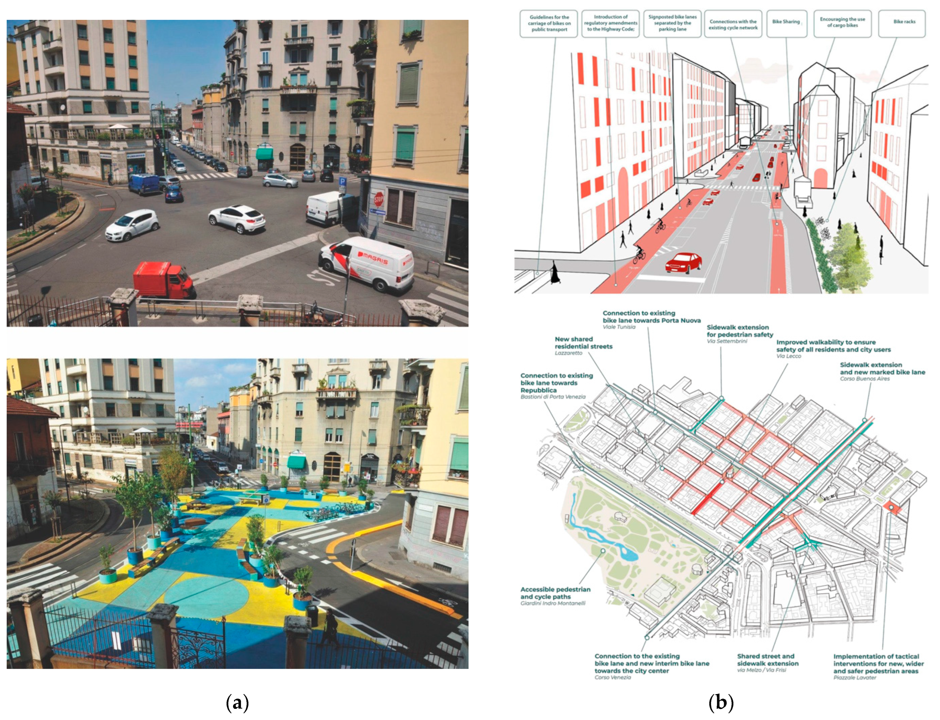
  143. Comune di Milano. Piazze Aperte; updated on 01/09/2021. 2021. Available online: https://www.comune.milano.it/aree-tematiche/quartieri/piano-quartieri/piazze-aperte/il-progetto (accessed on 30 March 2022).
  144. Comune di Milano. Open Streets: Strategies, Actions and Tools for Cycling and Walking Ensuring Distancing Measures within the Urban Travel and towards a Sustainable Mobility. 2020. Available online: https://www.comune.milano.it/-/quartieri.-con-strade-aperte-nuove-aree-pedonali-ciclabili-zone-30-e-spazi-pubblici (accessed on 30 March 2022).
  145. Bonfantini, B. Milano nel piano: Città di quartieri e d’urbanistica paratattica. Urban. Inf. 2021, 300, 12–17. [Google Scholar]
  146. Comune di Milano. Documento di Piano. Relazione Generale e Norme di Attuazione, Piano di Governo del Territorio. 2012. Available online: https://www.comune.milano.it/aree-tematiche/urbanistica-ed-edilizia/pgt-previgente/documento-di-piano/relazione-generale-e-documenti-introduttivi (accessed on 22 February 2022).
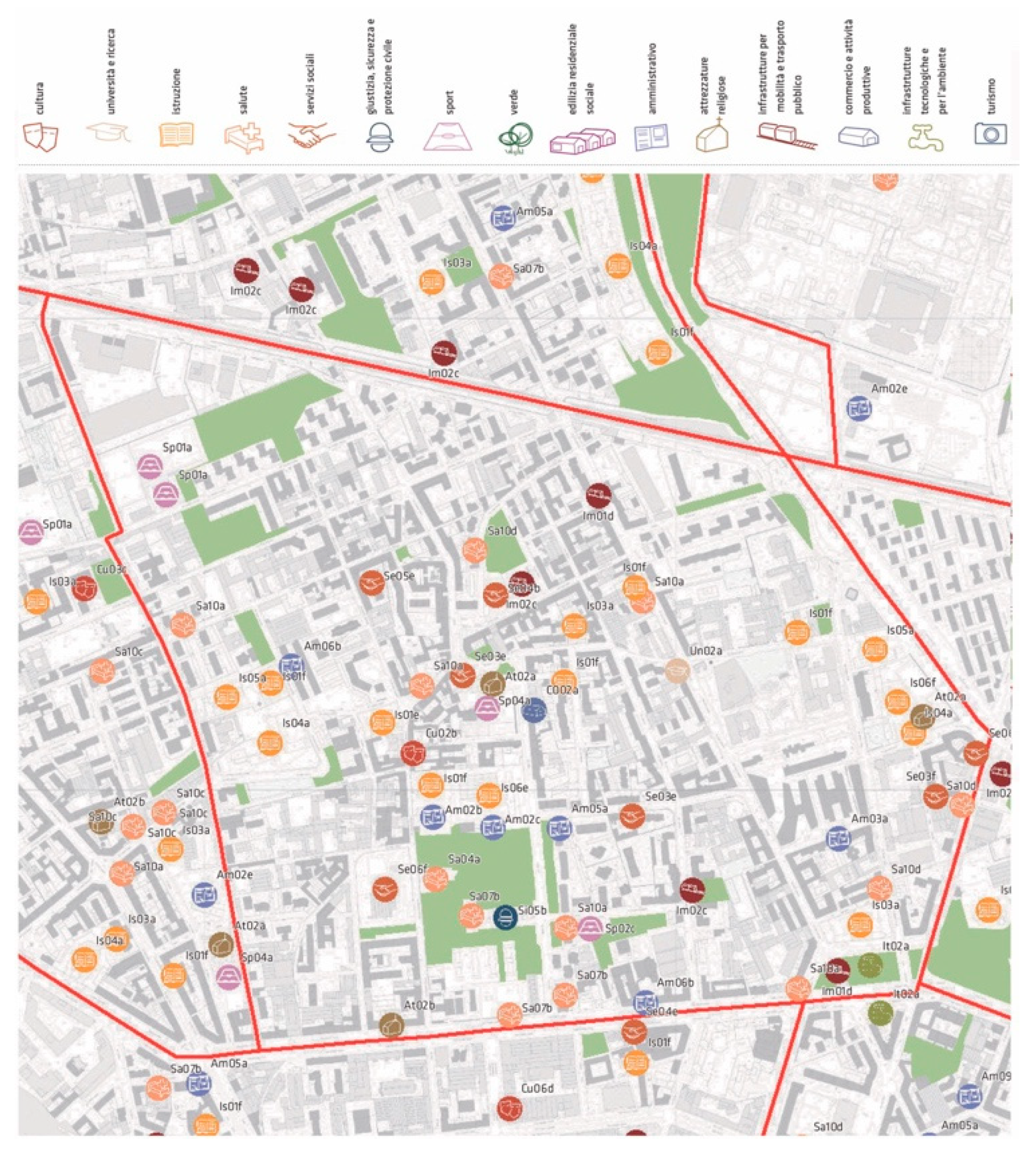
  147. Russi, N. Progettazione alla scala locale. I Nuclei di identità locale del Pgt di Milano. In Welfare e Territorio. Esplorare il Legame tra Politiche dei Servizi e Dimensione Urbana; Pomilio, F., Ed.; Alinea: Firenze, Italy, 2009; pp. 133–146. [Google Scholar]
  148. Comune di Milano. PGT. Piano dei Servizi. Catalogo, Schede NIL ed Elenchi dei Servizi, Piano di Governo del Territorio. 2012. Available online: https://www.comune.milano.it/aree-tematiche/urbanistica-ed-edilizia/pgt-previgente/piano-dei-servizi/catalogo-schede-nil-elenchi-dei-servizi (accessed on 30 March 2022).
  149. Alessandro Balducci. Le visioni per Milano fra strategia e pragmatismo/Visions for Milan, Between Strategies and Pragmatism. In Otto Racconti di Milano. Verso un Nuovo Progetto di Città/Eight Stories about Milan. Toward a New Project for the City; Galuzzi, P., Lavorato, A., Vitillo, P., Eds.; Assimpredil Ance: Milano, Italy, 2021; pp. 243–244, 264–265. [Google Scholar]
  150. von Foerster, H. Observing Systems; Intersystems: Seaside, FL, USA, 1982. [Google Scholar]
  151. Secchi, B. Prima Lezione di Urbanistica; Laterza: Roma-Bari, Italy, 2000. [Google Scholar]
  152. Foucault, M. Dits et Écrits; Gallimard: Paris, France, 1994; Volume III. [Google Scholar]
  153. Giaimo, C. (Ed.) Dopo 50 Anni di Standard Urbanistici in Italia. Verso Percorsi di Riforma; INU Edizioni: Roma, Italy, 2019. [Google Scholar]
  154. Laboratorio Standard. Diritti in Città. Gli Standard Urbanistici in Italia dal 1968 a Oggi; Donzelli: Roma, Italy, 2021. [Google Scholar]
  155. Marchigiani, E. An Accessible City is a Healthy and People-Centred Smart City. Int. J. Urban Plan. Smart Cities 2020, 1, 59–79. [Google Scholar] [CrossRef]
  156. Marchigiani, E.; Chiarelli, B.; Garofolo, I. Spatial accessibility as a driver to build an inclusive and proactive city. Urbani Izziv 2021, 32, 7–21. [Google Scholar] [CrossRef]
  157. Duany, A.; Steuteville, R. Defining the 15-Minute City. Public Square. 8 February 2021. Available online: https://www.cnu.org/publicsquare/2021/02/08/defining-15-minute-city (accessed on 30 March 2022).
  158. EU Horizon 2020. REPAiR—REsource Management in Peri-urban Areas: Going Beyond Urban Metabolism. 2016–2020. Available online: http://h2020repair.eu (accessed on 30 March 2022).
  159. Basso, S.; Di Biagi, P.; Crupi, V. Downscaling Food System for the ‘Public City’ Regeneration–An Experience of Social Agriculture in Trieste. Sustainability 2022, 14, 2769. [Google Scholar] [CrossRef]
  160. Croci, E.; Lucchitta, B. (Eds.) Nature-Based Solutions for More Sustainable Cities. A Framework Approach for Planning and Evaluation; Emerald Publishing Limited: Bingley, UK, 2022. [Google Scholar]
  161. Da Cunha, A.; Kaiser, C. Densité, Centralité et Qualité Urbaine: La Notion D’intensité, Outil pour une Gestion Adaptative des Formes Urbaines? Urbia 2009, 9, 13–56. Available online: https://www.unil.ch/files/live/sites/ouvdd/files/shared/URBIA/urbia_09/urbia_09_complet.pdf (accessed on 30 March 2022).
  162. D’Onofrio, R.; Talia, M. Densità e giusta distanza: Le nuove frontiere del progetto urbanistico della città post covid. BDC 2021, 1, 99–112. Available online: http://www.serena.unina.it/index.php/bdc/article/view/7990 (accessed on 30 March 2022).
  163. van Sparrentak, K.; Tackling Europe’s Housing Crisis. 21 June 2021. Available online: https://www.oecd-forum.org/posts/tackling-europe-s-housing-crisis (accessed on 30 March 2022).
  164. Rossi, M.; Perrone, C. Homing City. Un progetto di ricerca sulla gestione degli spazi minimi di prossimità nel welfare per il superamento delle crisi pandemiche. Contesti 2020, 2, 119–130. [Google Scholar] [CrossRef]
  165. Pierotti, P. Dopo il COVID Vogliamo Più Verde, Svago e Coworking ‘entro 15 Minuti da Casa’. ilsole24ore. 23 November 2020. Available online: https://www.ilsole24ore.com/art/dopo-covid-vogliamo-piu-verde-svago-e-coworking-entro-15-minuti-casa-AD8t3f3?refresh_ce=1 (accessed on 30 March 2022).
Figure 1. (a) Portland (Oregon, USA). The Healthy Connected City Network, Portland Plan, 2012. Source: [64]. (b) Portland. Urban Design Framework Map, 2035 Comprehensive Plan, 2020. Source: [66].
Sustainability 14 05468 g001
Figure 2. Melbourne (Australia). “20-Minute Neighbourhoods” pilot programme, Croydon South future opportunities, 2019. Source: [68].
Sustainability 14 05468 g002
Figure 3. Xian’an New Urban Area, Hebei Province (China). Planning according to the principles of the 15-Minute Life Circle. Source: [77].
Sustainability 14 05468 g003
Figure 4. (a) Milano (Italy). Open squares, the intersection of Spoleto and Venini streets before and after the tactical interventions. Source: [144]. (b) Milano. Open Streets, the new cycle path along Corso Buenos Aires (above), the actions in Porta Venezia-Lazzareto district (below). Source: [144].
Sustainability 14 05468 g004
Figure 5. (a) Milano. Nuclei of Local Identity, PGT, 2012. Source: [146]. (b) Milano. “One city, 88 neighbourhoods to call by name”, PGT, 2019. Source: [136].
Sustainability 14 05468 g005
Figure 6. Milano. Nuclei of Local Identity and the Plan of Services, existing and planned facilities and services in Dergano district, PGT, 2012. Source: [148].
Sustainability 14 05468 g006
Publisher’s Note: MDPI stays neutral with regard to jurisdictional claims in published maps and institutional affiliations.

