3D Structure from 2D Dimensional Images Using Structure from Motion Algorithms

Abstract
1. Introduction
2. The Historical Emara Palace in Najran
3. Materials and Methods
3.1. Digital Camera Used
3.2. Site Preparing and Imaging
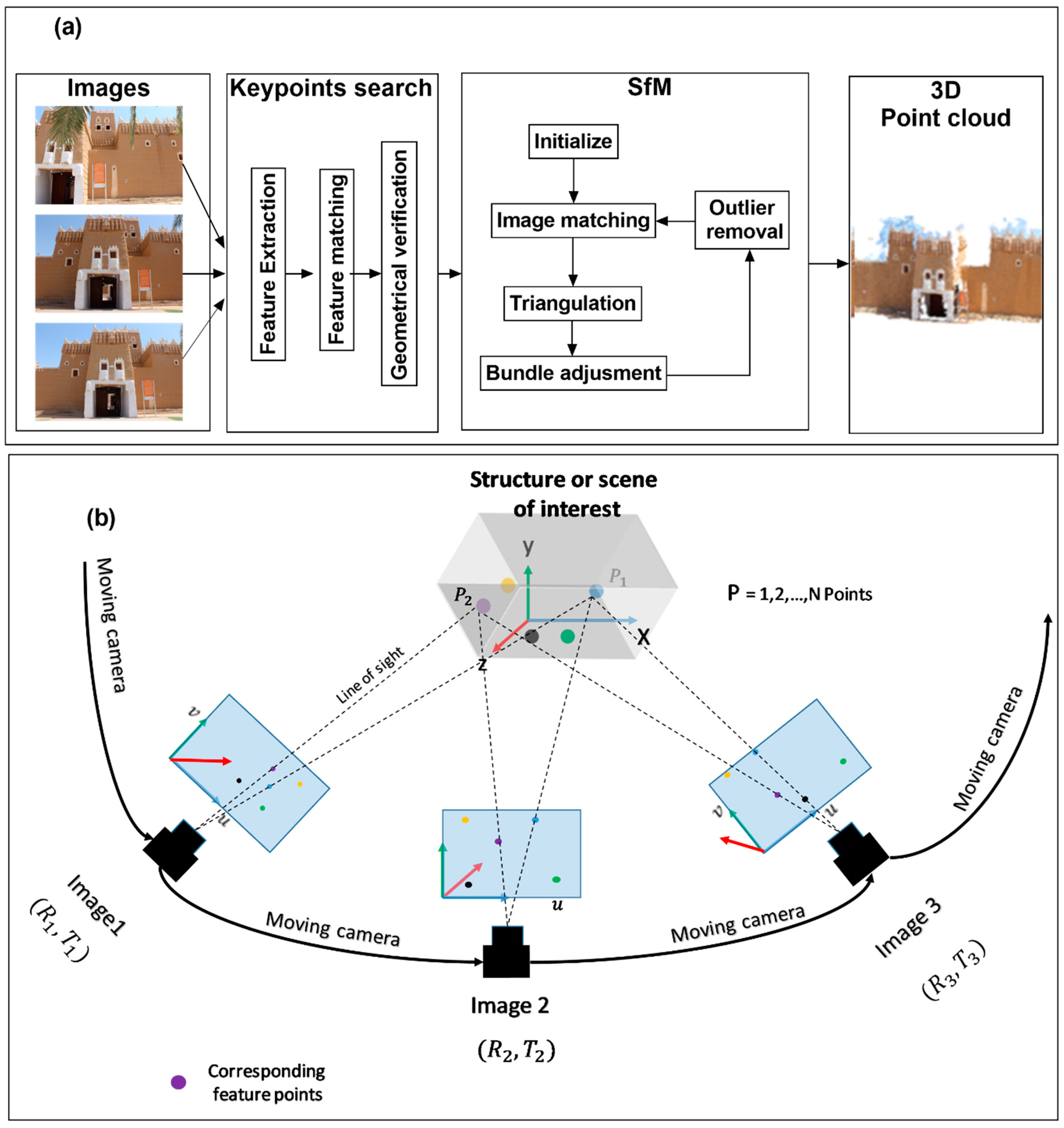
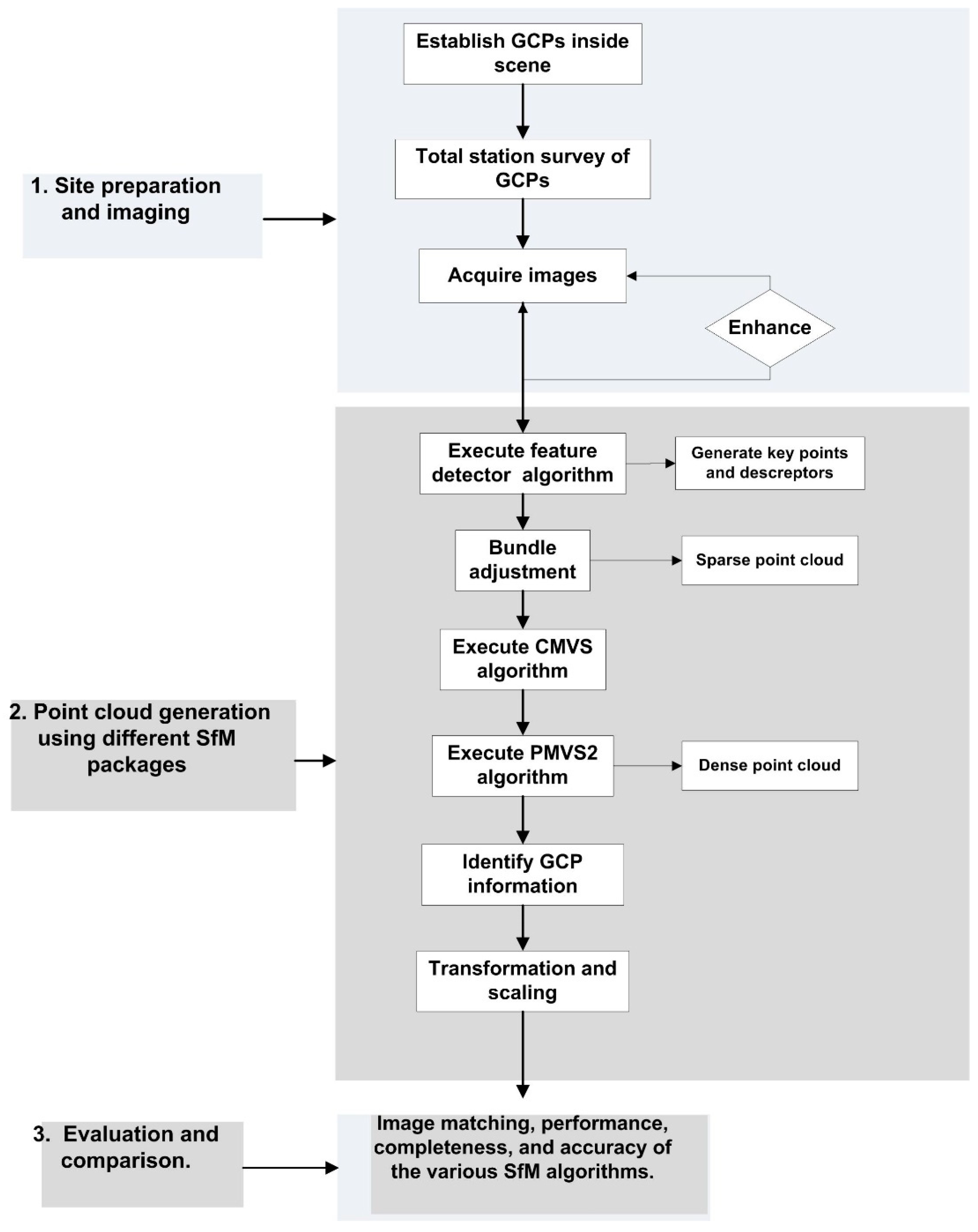
3.3. SfM Workflow
4. Three-Dimensional Point Clouds Based on Image Data and Existing Software
4.1. Imagery Acquisition for Generation of Point Cloud
4.2. Software Packages
- Agisoft Metashape commersoftware was used to process the overlapped captured images [29]. The general approach is as follows: the importation of photographs, alignment (creation of a sparse point cloud for image orientation using the SIFT technique and bundle block adjustment), the generation of point clouds, and the building of a mesh and texture.
- VisualSFM developed by Wu, 2013, http://ccwu.me/vsfm/ (accessed on 2 March 2022), is an open-source software package that processes the data on the local PC.
- Regad3D is also an open-source software package that uses an SfM tool that is free and open-source (https://www.regard3d.org/ (accessed on 3 March 2022)).
4.3. Results and Evaluation
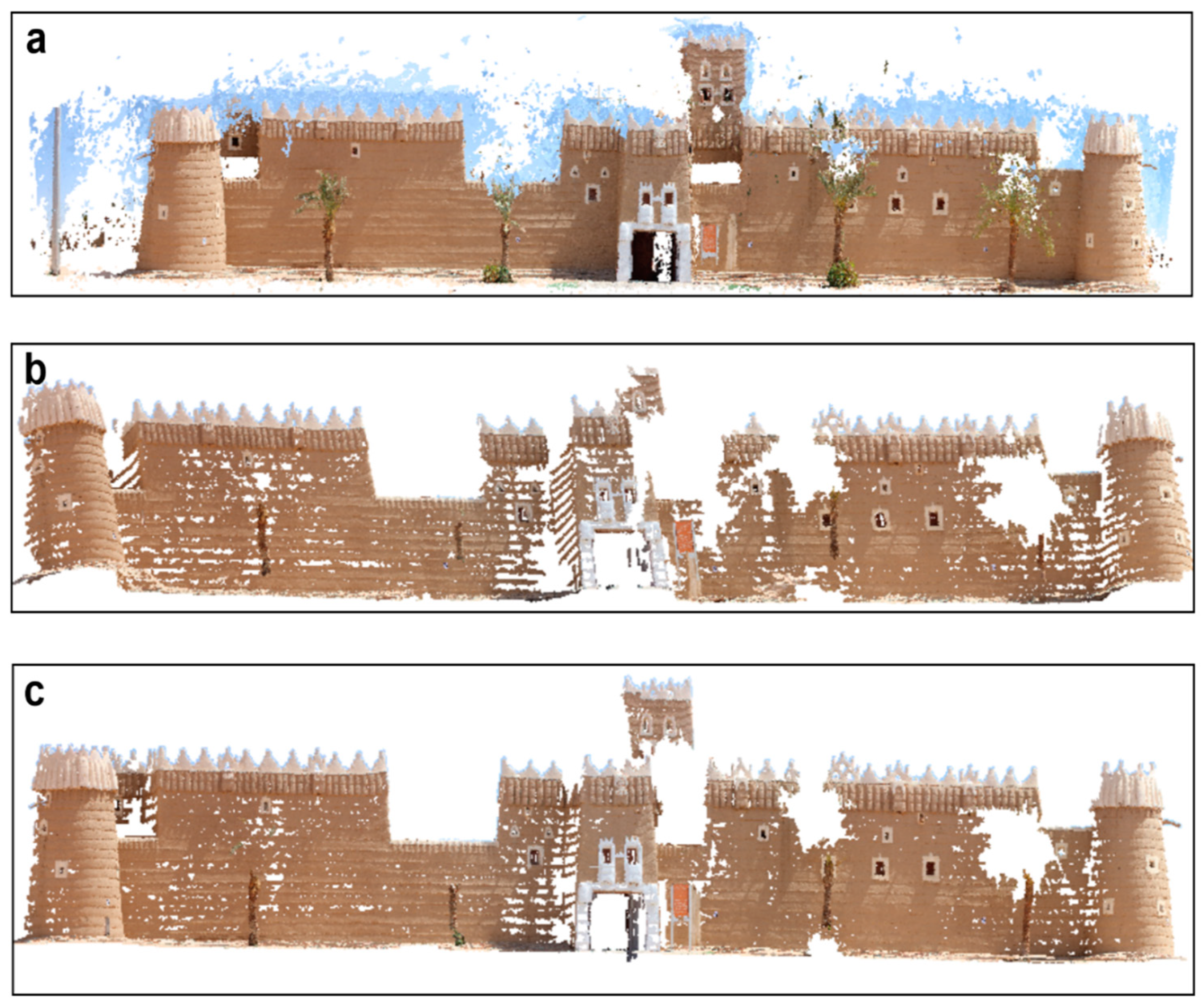
4.3.1. Performance and Completeness
4.3.2. Accuracy
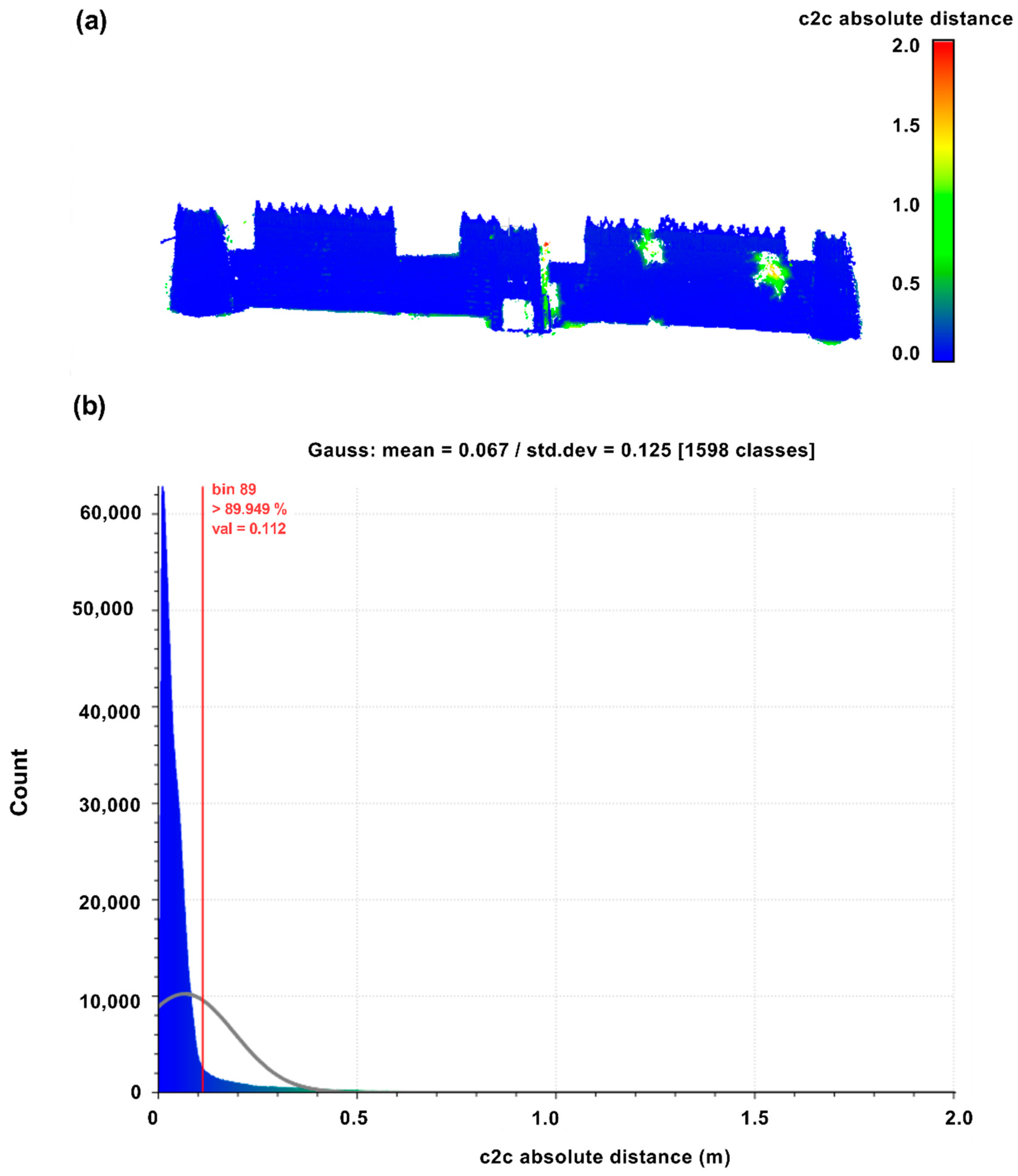
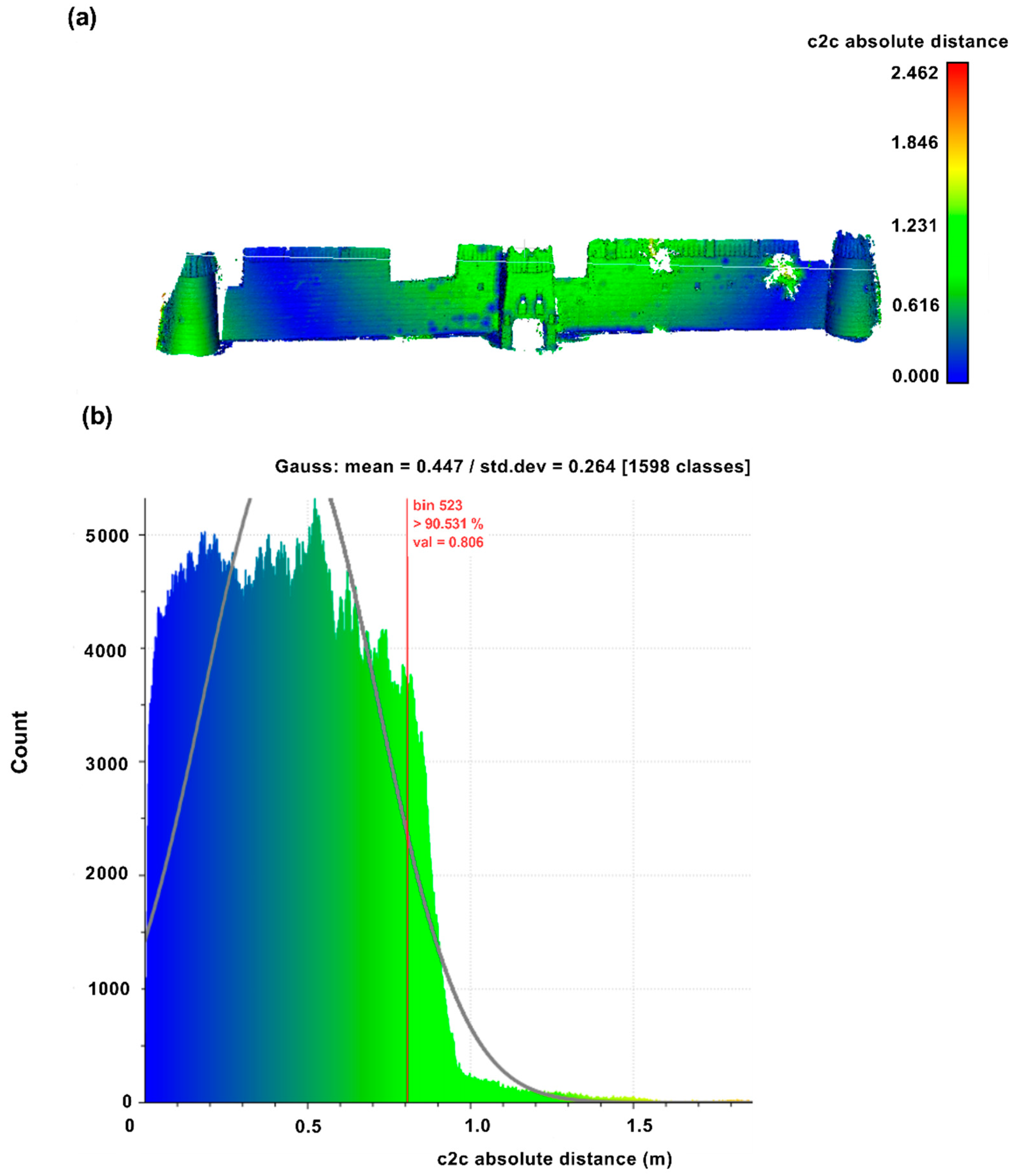
4.3.3. Direct Cloud-to-Cloud Comparison
5. Discussion
6. Conclusions
Funding
Informed Consent Statement
Data Availability Statement
Acknowledgments
Conflicts of Interest
References
- Peña-Villasenín, S.; Gil-Docampo, M.; Ortiz-Sanz, J. 3-D Modeling of Historic Façades Using SFM Photogrammetry Metric Documentation of Different Building Types of a Historic Center. Int. J. Arch. Herit. 2017, 11, 871–890. [Google Scholar] [CrossRef] [Scilit]
- Mancini, F.; Pirotti, F. Innovations in photogrammetry and remote sensing: Modern sensors, new processing strategies and frontiers in applications. Sensors 2021, 21, 2420. [Google Scholar] [CrossRef] [Scilit] [PubMed]
- Sansoni, G.; Trebeschi, M.; Docchio, F. State-of-the-art and applications of 3D imaging sensors in industry, cultural heritage, medicine, and criminal investigation. Sensors 2009, 9, 568–601. [Google Scholar] [CrossRef] [Scilit] [PubMed]
- Karagianni, A. Terrestrial laser scanning and satellite data in cultural heritage building documentation. Int. Arch. Photogramm. Remote Sens. Spat. Inf. Sci. 2021, 46, 361–366. [Google Scholar] [CrossRef] [Scilit]
- Elkhrachy, I. Modeling and Visualization of Three Dimensional Objects Using Low-Cost Terrestrial Photogrammetry. Int. J. Arch. Herit. 2019, 14, 1456–1467. [Google Scholar] [CrossRef] [Scilit]
- Moyano, J.E.; Nieto-Julián, J.E.; Lenin, L.M.; Bruno, S. Operability of Point Cloud Data in an Architectural Heritage Information Model. Int. J. Arch. Herit. 2021, 1–20. [Google Scholar] [CrossRef] [Scilit]
- Kersten, T.P.; Mechelke, K.; Maziull, L. 3D model of al zubarah fortress in qatar-Terrestrial laser scanning vs. dense image matching. Int. Arch. Photogramm. Remote Sens. Spat. Inf. Sci. 2015, 40, 1–8. [Google Scholar] [CrossRef] [Scilit]
- Grussenmeyer, P.; Landes, T.; Voegtle, T.; Ringle, K. Comparison Methods of Terrestrial Laser Scanning, Photogrammetry and Tacheometry Data for Recording of Cultural Heritage Buildings. Int. Arch. Photogramm. Remote Sens. Spat. Inf. Sci. 2008, 37, 213–218. Available online: https://www.scopus.com/inward/record.uri?eid=2-s2.0-84981192332&partnerID=40&md5=49320dead7a8eec25ae4c19010b5c0b9 (accessed on 5 March 2022).
- Yastikli, N. Documentation of cultural heritage using digital photogrammetry and laser scanning. J. Cult. Herit. 2007, 8, 423–427. [Google Scholar] [CrossRef] [Scilit]
- Lerma, J.L.; Navarro, S.; Cabrelles, M.; Villaverde, V. Terrestrial laser scanning and close range photogrammetry for 3D archaeological documentation: The Upper Palaeolithic Cave of Parpalló as a case study. J. Archaeol. Sci. 2010, 37, 499–507. [Google Scholar] [CrossRef] [Scilit]
- Atkinson, K.B. Introduction to Modern Photogrammetry. Photogramm. Rec. 2003, 18, 329–330. [Google Scholar] [CrossRef] [Scilit]
- Granshaw, S.I. Close Range Photogrammetry: Principles, Methods and Applications. Photogramm. Rec. 2010, 25, 203–204. [Google Scholar] [CrossRef] [Scilit]
- Iglhaut, J.; Cabo, C.; Puliti, S.; Piermattei, L.; O’Connor, J.; Rosette, J. Structure from Motion Photogrammetry in Forestry: A Review. Curr. For. Rep. 2019, 5, 155–168. [Google Scholar] [CrossRef] [Scilit]
- Micheletti, N.; Chandler, J.H.; Lane, S.N. Investigating the geomorphological potential of freely available and accessible structure-from-motion photogrammetry using a smartphone. Earth Surf. Process. Landf. 2014, 40, 473–486. [Google Scholar] [CrossRef] [Scilit]
- Westoby, M.; Brasington, J.; Glasser, N.F.; Hambrey, M.J.; Reynolds, J.M. ‘Structure-from-Motion’ photogrammetry: A low-cost, effective tool for geoscience applications. Geomorphology 2012, 179, 300–314. [Google Scholar] [CrossRef] [Scilit]
- Bemis, S.; Micklethwaite, S.; Turner, D.; James, M.R.; Akciz, S.; Thiele, S.T.; Bangash, H.A. Ground-based and UAV-Based photogrammetry: A multi-scale, high-resolution mapping tool for structural geology and paleoseismology. J. Struct. Geol. 2014, 69, 163–178. [Google Scholar] [CrossRef] [Scilit]
- Wang, S.; Clark, R.; Wen, H.; Trigoni, N. Deepvo: Towards end-to-end visual odometry with deep recurrent convolutional neural networks. In Proceedings of the 2017 IEEE international conference on robotics and automation (ICRA), Singapore, 29 May–3 June 2017; pp. 2043–2050. [Google Scholar]
- Zhou, T.; Brown, M.; Snavely, N.; Lowe, D.G. Unsupervised learning of depth and ego-motion from video. In Proceedings of the IEEE Conference on Computer Vision and Pattern Recognition, Honolulu, HI, USA, 21–26 July 2017; pp. 1851–1858. [Google Scholar]
- Klodt, M.; Vedaldi, A. Supervising the new with the old: Learning sfm from sfm. In Proceedings of the European Conference on Computer Vision (ECCV), Munich, Germany, 8–14 September 2018; pp. 698–713. [Google Scholar]
- Liu, J.; Ding, H.; Shahroudy, A.; Duan, L.-Y.; Jiang, X.; Wang, G.; Kot, A.C. Feature boosting network for 3d pose estimation. IEEE Trans. Pattern Anal. Mach. Intell. 2019, 42, 494–501. [Google Scholar] [CrossRef] [Scilit]
- Wei, X.; Zhang, Y.; Li, Z.; Fu, Y.; Xue, X. DeepSFM: Structure from Motion via Deep Bundle Adjustment. In European Conference on Computer Vision; Springer: Cham, Switzerland, 2020; pp. 230–247. [Google Scholar] [CrossRef] [Scilit]
- Ulvi, A. Documentation, Three-Dimensional (3D) Modelling and visualization of cultural heritage by using Unmanned Aerial Vehicle (UAV) photogrammetry and terrestrial laser scanners. Int. J. Remote Sens. 2021, 42, 1994–2021. [Google Scholar] [CrossRef] [Scilit]
- Esposito, S.; Fallavollitaa, P.; Wahbeh, W.; Nardinocchic, C.; Balsia, M. Performance evaluation of UAV photogrammetric 3D reconstruction. In Proceedings of the International Geoscience and Remote Sensing Symposium (IGARSS), Quebec City, QC, Canada, 13–18 July 2014; pp. 4788–4791. [Google Scholar] [CrossRef] [Scilit]
- Altman, S.; Xiao, W.; Grayson, B. Evaluation of Low-Cost Terrestrial Photogrammetry for 3D Reconstruction of Complex Buildings. ISPRS Ann. Photogramm. Remote Sens. Spat. Inf. Sci. 2017, 4, 199–206. [Google Scholar] [CrossRef] [Scilit]
- Kingsland, K. Comparative analysis of digital photogrammetry software for cultural heritage. Digit. Appl. Archaeol. Cult. Herit. 2020, 18, e00157. [Google Scholar] [CrossRef] [Scilit]
- Niederheiser, R.; Mokroš, M.; Lange, J.; Petschko, H.; Prasicek, G.; Elberink, S.O. Deriving 3D point clouds from terrestrial photographs—Comparison of different sensors and software. ISPRS Int. Arch. Photogramm. Remote Sens. Spat. Inf. Sci. 2016, 41, 685–692. [Google Scholar] [CrossRef] [Scilit]
- Alidoost, F.; Arefi, H. Comparison of uas-based photogrammetry software for 3D point cloud generation: A survey over a historical site. ISPRS Ann. Photogramm. Remote Sens. Spat. Inf. Sci. 2017, 4, 55–61. [Google Scholar] [CrossRef] [Scilit]
- Remondino, F.; Rizzi, A. Reality-based 3D documentation of natural and cultural heritage sites—Techniques, problems, and examples. Appl. Geomat. 2010, 2, 85–100. [Google Scholar] [CrossRef] [Scilit]
- Agisoft LLC. Agisoft PhotoScan User Manual: Professional Edition. Version 1.2User Manuals. 2016, p. 97. Available online: http://www.agisoft.com/downloads/user-manuals/ (accessed on 15 March 2022).
- Tomasi, C.; Kanade, T. Shape and motion from image streams: A factorization method. Proc. Natl. Acad. Sci. USA 1993, 90, 9795–9802. [Google Scholar] [CrossRef] [Scilit]
- Remondino, F.; Fraser, C. Digital camera calibration methods: Considerations and comparisons. Int. Arch. Photogramm. Remote Sens. Spat. Inf. Sci. 2006, 36, 266–272. [Google Scholar]
- Lowe, D.G. Distinctive Image Features from Scale-Invariant Keypoints. Int. J. Comput. Vis. 2004, 60, 91–110. [Google Scholar] [CrossRef] [Scilit]
- Li, Q.; Wang, G.; Liu, J.; Chen, S. Robust Scale-Invariant Feature Matching for Remote Sensing Image Registration. IEEE Geosci. Remote Sens. Lett. 2009, 6, 287–291. [Google Scholar] [CrossRef] [Scilit]
- Bay, H.; Tuytelaars, T.; Van Gool, L. Surf: Speeded up robust features. In Lecture Notes in Computer Science (including Subseries Lecture Notes in Artificial Intelligence and Lecture Notes in Bioinformatics); Springer: Berlin/Heidelberg, Germany, 2006; Volume 3951, pp. 404–417. [Google Scholar] [CrossRef] [Scilit]
- Herbert, B.; Andreas, E.; Tinne, T.; Luc, V.G. Speeded-up robust features (SURF). Comput. Vis. Image Underst. 2008, 110, 346–359. [Google Scholar] [CrossRef] [Scilit]
- Schonberger, J.L.; Frahm, J.-M. Structure-from-motion revisited. In Proceedings of the IEEE Conference on Computer Vision and Pattern Recognition, Las Vegas, NV, USA, 27–30 June 2016; pp. 4104–4113. [Google Scholar]
- Stewart, J. Calculus, Concepts and Contexts; Cengage Learning: Boston, MA, USA, 1998. [Google Scholar]
- Fischler, M.A.; Bolles, R.C. Random sample consensus: A Paradigm for Model Fitting with Applications to Image Analysis and Automated Cartography. Commun. ACM 1981, 24, 381–395. [Google Scholar] [CrossRef] [Scilit]
- Kim, T.; Im, Y.-J. Automatic satellite image registration by combination of matching and random sample consensus. IEEE Trans. Geosci. Remote Sens. 2003, 41, 1111–1117. [Google Scholar] [CrossRef] [Scilit]
- Furukawa, Y.; Ponce, J. Accurate, dense, and robust multiview stereopsis. IEEE Trans. Pattern Anal. Mach. Intell. 2009, 32, 1362–1376. [Google Scholar] [CrossRef] [Scilit]
- Agarwal, S.; Furukawa, Y.; Snavely, N.; Simon, I.; Curless, B.; Seitz, S.M.; Szeliski, R. Building Rome in a day. Commun. ACM 2011, 54, 105–112. [Google Scholar] [CrossRef] [Scilit]
- Vergauwen, M.; Van Gool, L. Web-based 3D reconstruction service. Mach. Vis. Appl. 2006, 17, 411–426. [Google Scholar] [CrossRef] [Scilit]
- Bolles, R.C.; Baker, H.H.; Marimont, D.H. Epipolar-plane image analysis: An approach to determining structure from motion. Int. J. Comput. Vis. 1987, 1, 7–55. [Google Scholar] [CrossRef] [Scilit]
- Fonstad, M.A.; Dietrich, J.T.; Courville, B.C.; Jensen, J.L.; Carbonneau, P.E. Topographic structure from motion: A new development in photogrammetric measurement. Earth Surf. Process. Landf. 2012, 38, 421–430. [Google Scholar] [CrossRef] [Scilit]
- Ullman, S. The interpretation of structure from motion. Proc. R. Soc. B 1979, 203, 405–426. [Google Scholar] [CrossRef] [Scilit]
- Akpo, H.A.; Atindogbé, G.; Obiakara, M.C.; Adjinanoukon, A.B.; Gbedolo, M.; Fonton, N.H. Accuracy of common stem volume formulae using terrestrial photogrammetric point clouds: A case study with savanna trees in Benin. J. For. Res. 2021, 32, 2415–2422. [Google Scholar] [CrossRef] [Scilit]
- Dwyer, R.A. A faster divide-and-conquer algorithm for constructing delaunay triangulations. Algorithmica 1987, 2, 137–151. [Google Scholar] [CrossRef] [Scilit]
- Girardeau-Montaut, D.; Roux, M.; Marc, R.; Thibault, G. Change detection on points cloud data acquired with a ground laser scanner. Int. Arch. Photogramm. Remote Sens. Spat. Inf. Sci. 2005, 36, W19. [Google Scholar]
- Ranzuglia, G.; Callieri, M.; Dellepiane, M.; Cignoni, P.; Scopigno, R. MeshLab as a complete tool for the integration of photos and color with high resolution 3D geometry data. CAA 2012 Conf. Proc. 2013, 2, 406–416. [Google Scholar]
- Cignoni, P.; Rocchini, C.; Scopigno, R. Metro: Measuring Error on Simplified Surfaces. Comput. Graph. Forum 1998, 17, 167–174. [Google Scholar] [CrossRef] [Scilit]
- Marapane, S.; Trivedi, M. Multi-primitive hierarchical (MPH) stereo analysis. IEEE Trans. Pattern Anal. Mach. Intell. 1994, 16, 227–240. [Google Scholar] [CrossRef] [Scilit]
- Sun, Y.; Zhao, L.; Huang, S.; Yan, L.; Dissanayake, G. Line matching based on planar homography for stereo aerial images. ISPRS J. Photogramm. Remote Sens. 2015, 104, 1–17. [Google Scholar] [CrossRef] [Scilit]



| Sensor size | 22.3 mm × 14.9 mm |
| Pixel dimensions | 5184 × 3456 |
| Camera model | Canon EOS Rebel T3i/600D |
| Megapixels | 18.7 |
| Pixel size | 4.30 µm |
| Angle measurement | Display resolution | 0.1″ |
| Accuracy | 1″ | |
| Distance measurement | Reflectorless (m) | 2 mm + 2 ppm |
| Prism (m) | 1.5 mm + 2 ppm | |
| Telescope | Magnification | 30× |
| Field of view | 1°30′ (1.66 gons) 2.7 m at 100 m |
| Software Products | Feature Matching | Bundle Adjustment | Completeness | |
|---|---|---|---|---|
| Images | Points | |||
| Agisoft Metashape | 36.12 | 77 | 58/98 | 47,133 |
| VisualSFM | 52.17 | 14.03 | 55/98 | 37,158 |
| Regad3D | 244.6 | 18.5 | 57/98 | 45,029 |
| Nr. | Target Label | Error (m) | X Error (m) | Y Error (m) | Z Error (m) |
|---|---|---|---|---|---|
| 1 | T1 | 0.01206 | −0.00419 | −0.00535 | 0.009961 |
| 2 | T3 | 0.011339 | 0.002024 | 0.001014 | −0.01111 |
| 3 | T11 | 0.002511 | 0.001865 | −0.00144 | −0.00087 |
| 4 | T13 | 0.001467 | 0.000207 | 0.001451 | −6.3 × 10⁻⁵ |
| 5 | T15 | 0.003757 | 0.001207 | 0.003447 | −0.00088 |
| 6 | T17 | 0.005028 | 0.002652 | 0.003855 | 0.001841 |
| 7 | T23 | 0.000654 | −6.8 × 10⁻⁵ | −0.00039 | 0.000522 |
| 8 | T25 | 0.005267 | 0.003245 | −0.00316 | −0.00269 |
| RMSE | 0.007 m | ||||
| Nr. | Target Label | Error (m) | X Error (m) | Y Error (m) | Z Error (m) |
|---|---|---|---|---|---|
| 1 | T2 | 0.008603 | 0.000777 | 0.004934 | −0.007 |
| 2 | T4 | 0.009766 | 0.0003 | −0.00155 | 0.009637 |
| 3 | T10 | 0.002518 | −0.00105 | 0.000635 | −0.0022 |
| 4 | T12 | 0.00461 | −0.00307 | −0.00313 | 0.001428 |
| 5 | T14 | 0.003192 | −0.0016 | −0.00261 | −0.00089 |
| 6 | T16 | 0.002553 | −0.00018 | −0.0023 | 0.001102 |
| 7 | T22 | 0.003538 | −0.00227 | 0.002307 | 0.001436 |
| 8 | T24 | 0.001872 | 0.000028 | 0.001862 | −0.00018 |
| RMSE | 0.005 m | ||||
| Target Label | Agisoft Metashape Error (m) | VisualSFM Error (m) | Regard3D Error (m) |
|---|---|---|---|
| T1 | 0.00429 | 0.72945 | 0.03489 |
| T2 | 0.00615 | 0.13299 | 0.02914 |
| T3 | 0.00350 | 0.72811 | 0.02797 |
| T4 | 0.00287 | 0.57834 | 0.04189 |
| T5 | 0.00050 | 0.71424 | 0.02268 |
| RMSE | 0.004 m | 0.620 m | 0.032 m |
| RMSE without GCPs | 0.79 (pixels) | Not provided | Not provided |
Publisher’s Note: MDPI stays neutral with regard to jurisdictional claims in published maps and institutional affiliations. |
© 2022 by the author. Licensee MDPI, Basel, Switzerland. This article is an open access article distributed under the terms and conditions of the Creative Commons Attribution (CC BY) license (https://creativecommons.org/licenses/by/4.0/).
Share and Cite
Elkhrachy, I. 3D Structure from 2D Dimensional Images Using Structure from Motion Algorithms. Sustainability 2022, 14, 5399. https://doi.org/10.3390/su14095399
Elkhrachy I. 3D Structure from 2D Dimensional Images Using Structure from Motion Algorithms. Sustainability. 2022; 14(9):5399. https://doi.org/10.3390/su14095399
Chicago/Turabian StyleElkhrachy, Ismail. 2022. "3D Structure from 2D Dimensional Images Using Structure from Motion Algorithms" Sustainability 14, no. 9: 5399. https://doi.org/10.3390/su14095399
APA StyleElkhrachy, I. (2022). 3D Structure from 2D Dimensional Images Using Structure from Motion Algorithms. Sustainability, 14(9), 5399. https://doi.org/10.3390/su14095399